Rare Earth Elements (REE) Deposits Associated with Great Plain Margin Deposits (Alkaline-Related), Southwestern United States and Eastern Mexico


Abstract
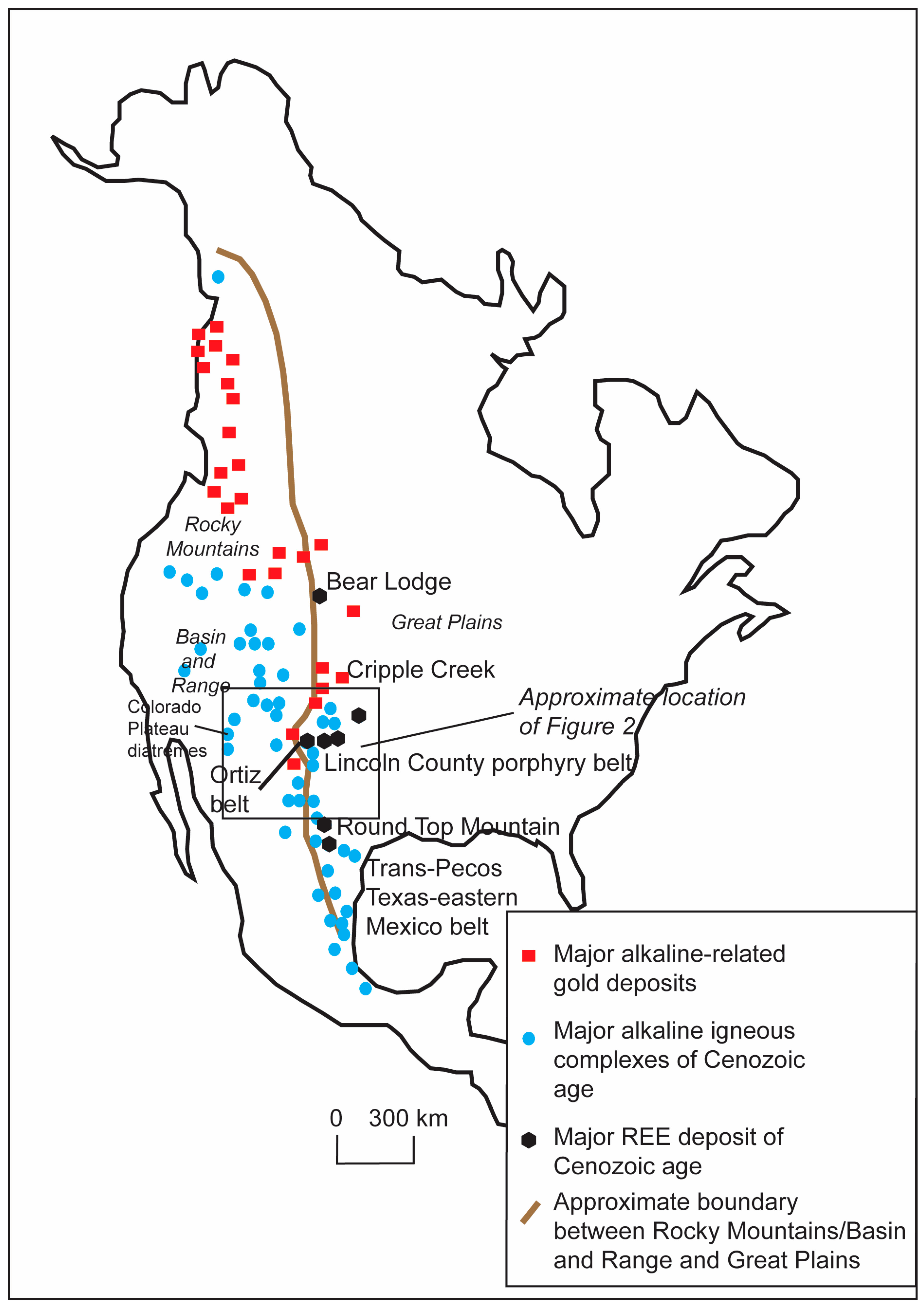
:1. Introduction
2. Materials and Methods
3. Descriptions of Selected Areas
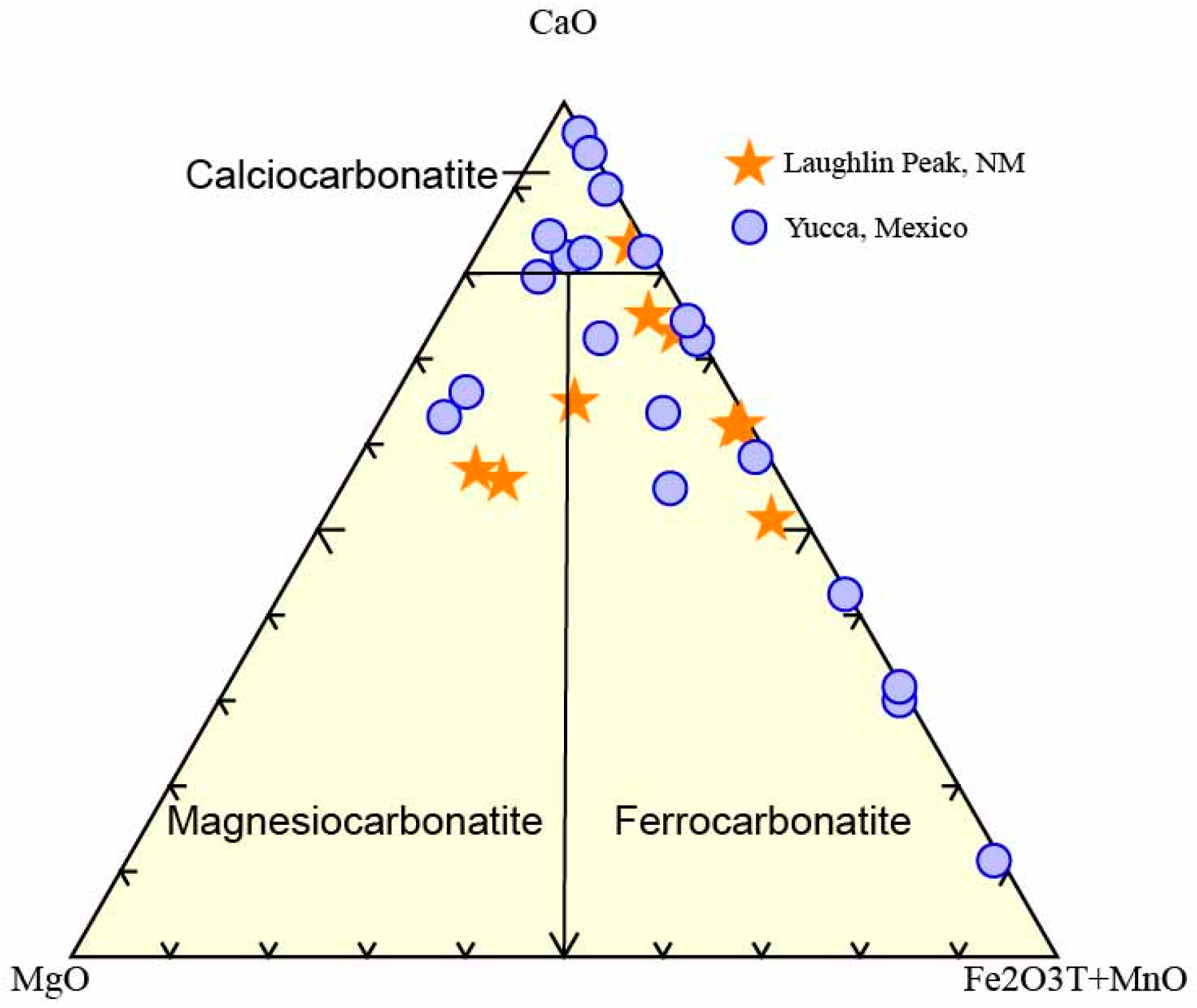
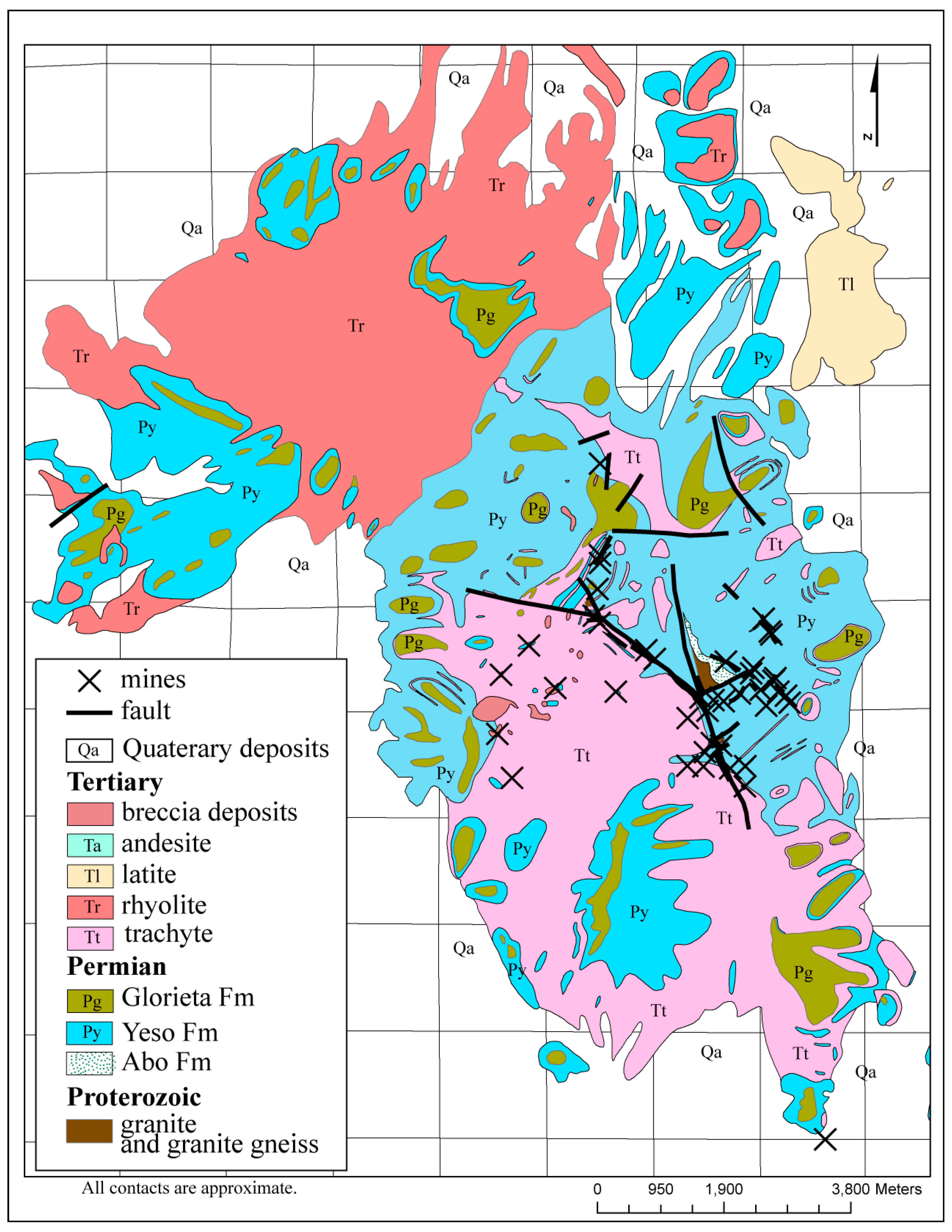
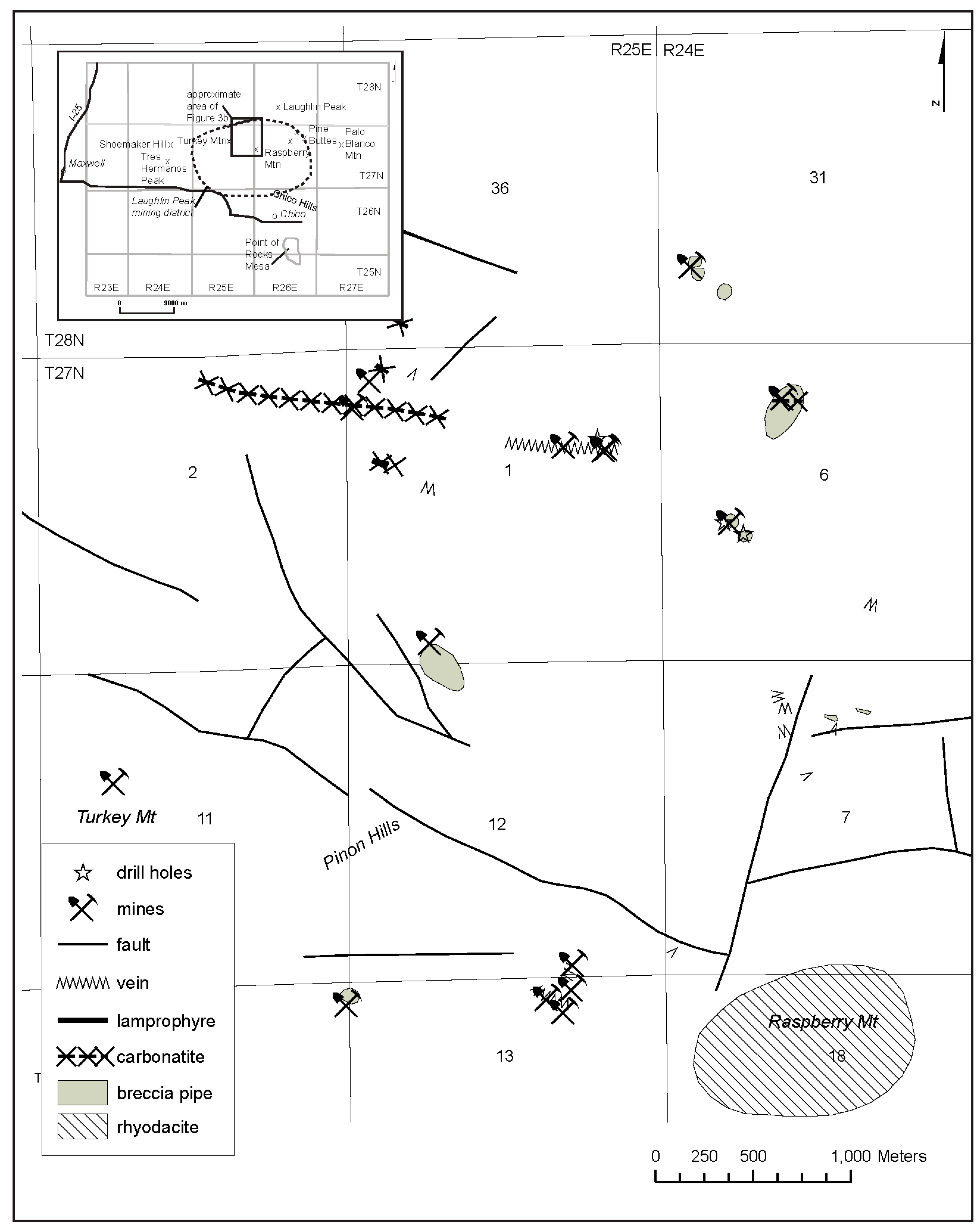
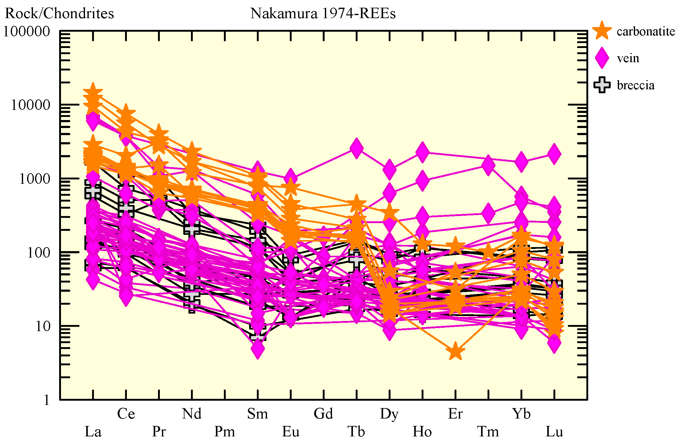
3.1. Laughlin Peak District
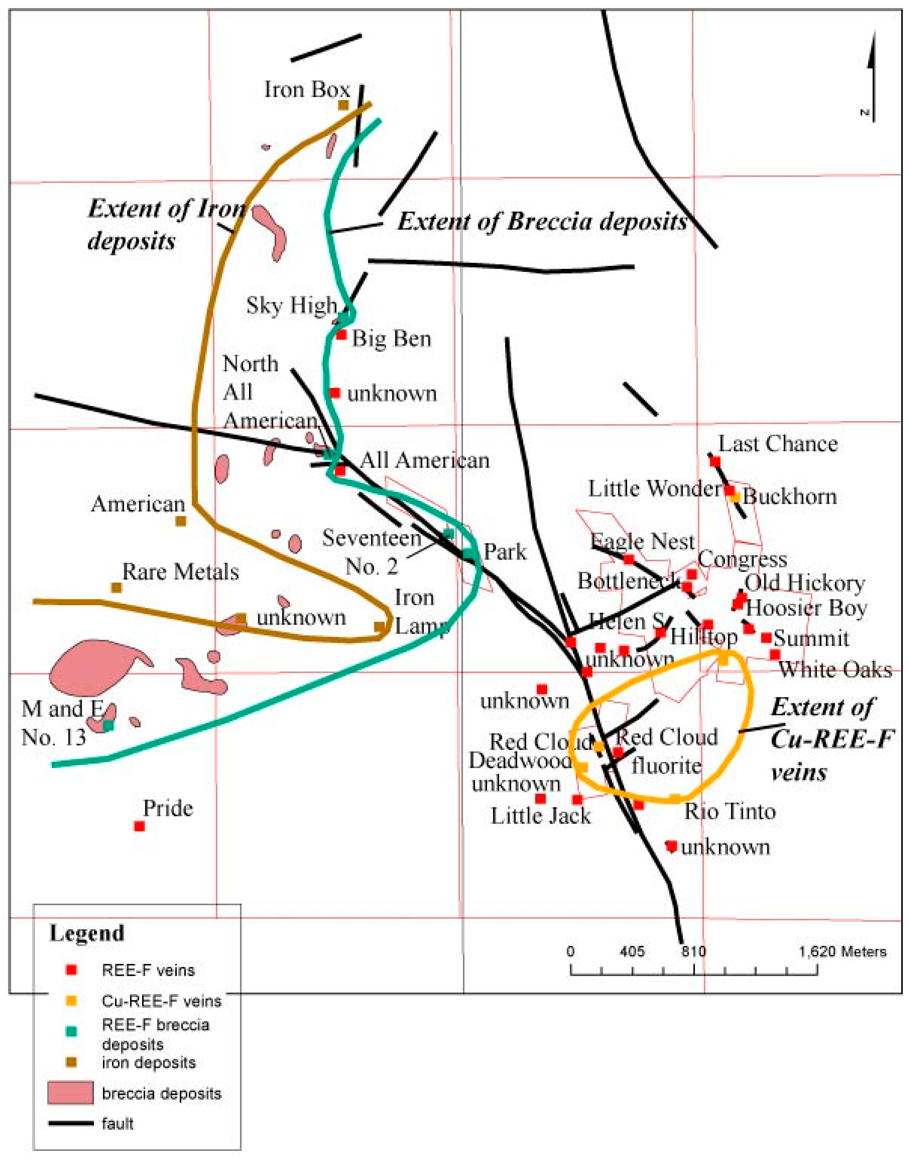
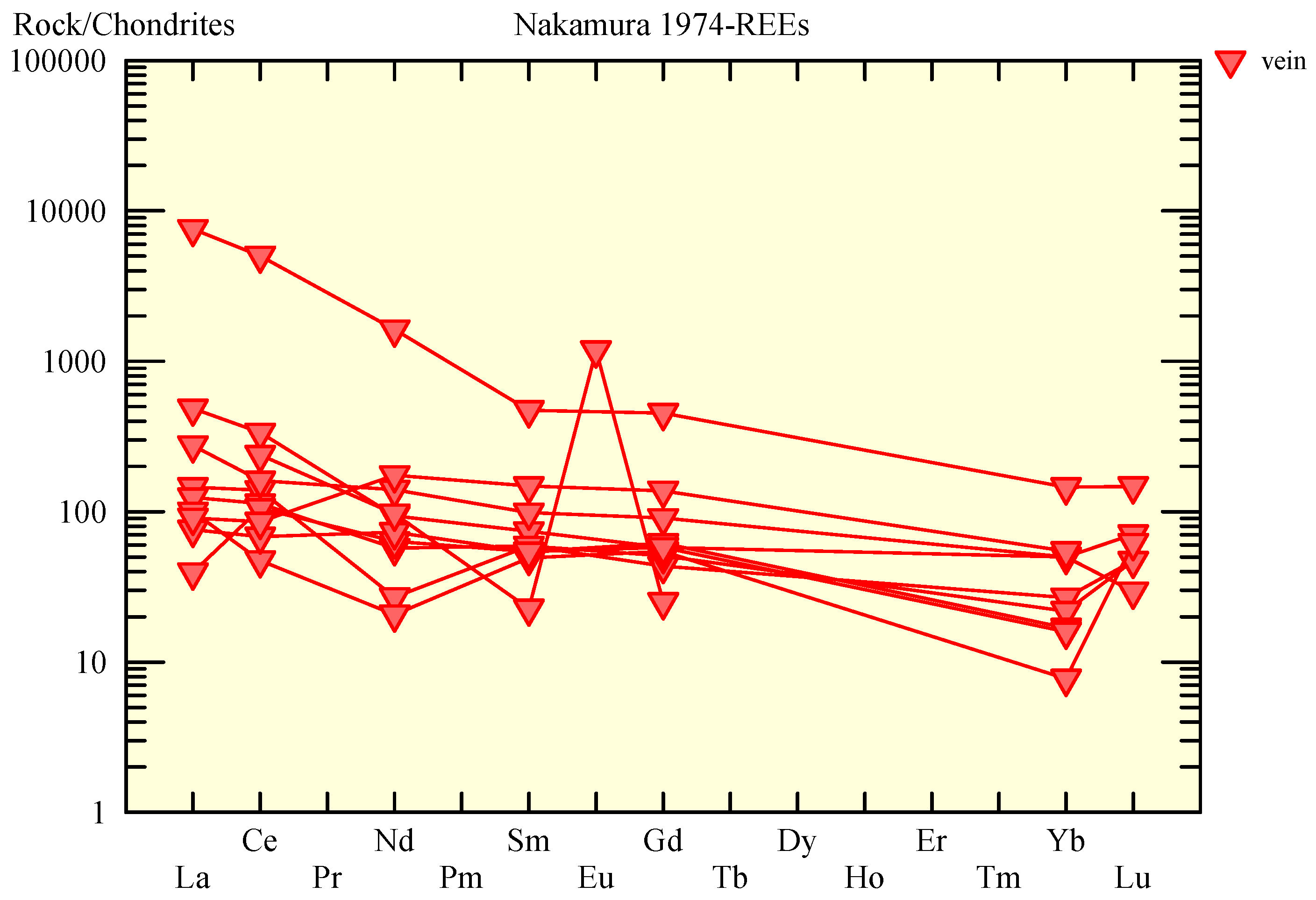
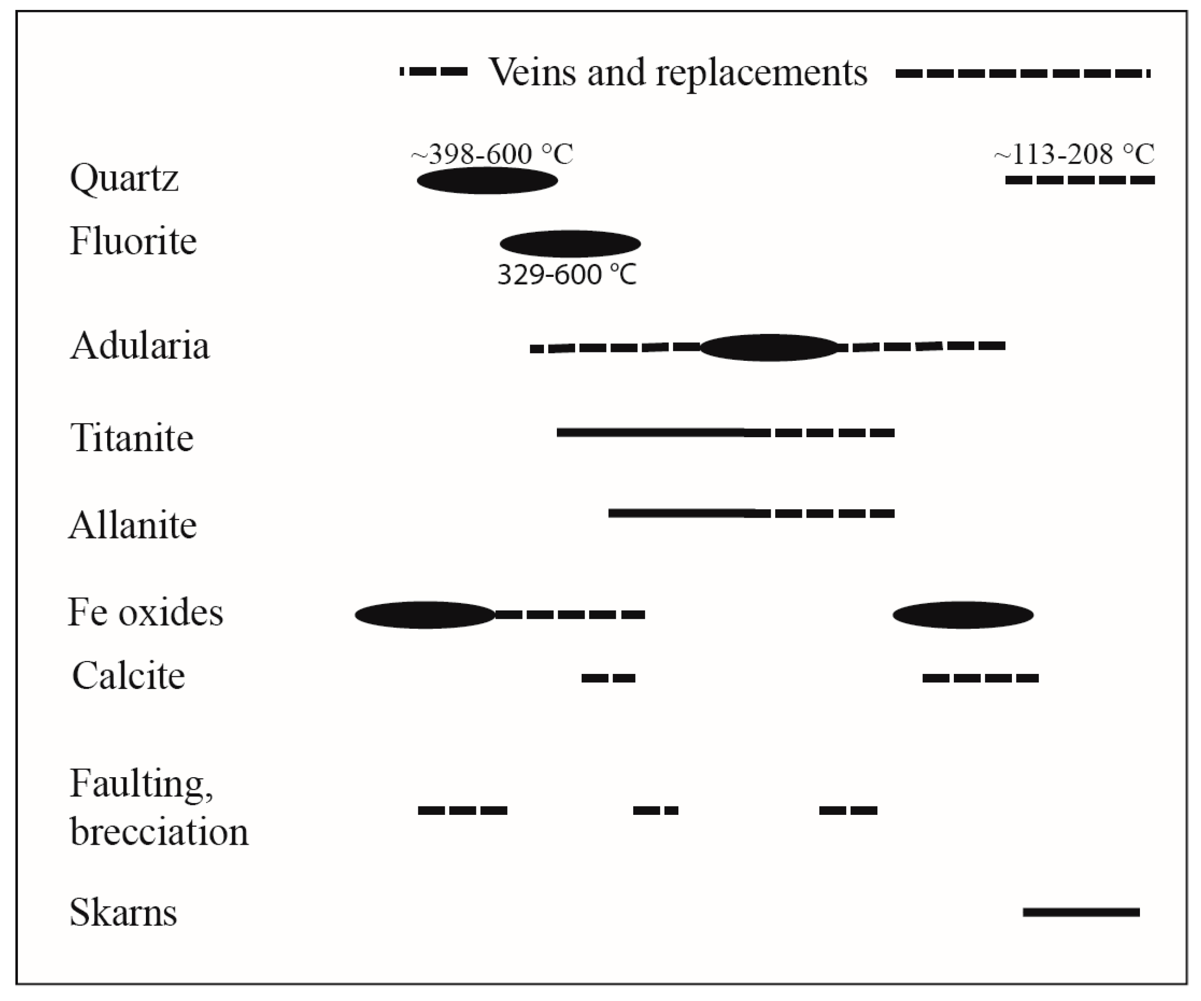
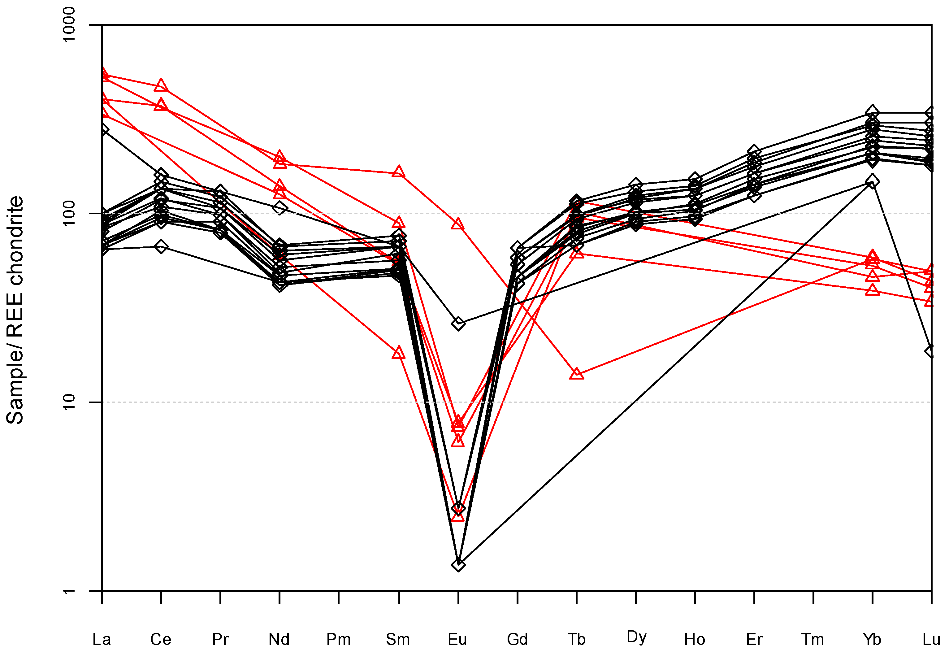
3.2. Gallinas Mountains District
3.3. Capitan Mountains District
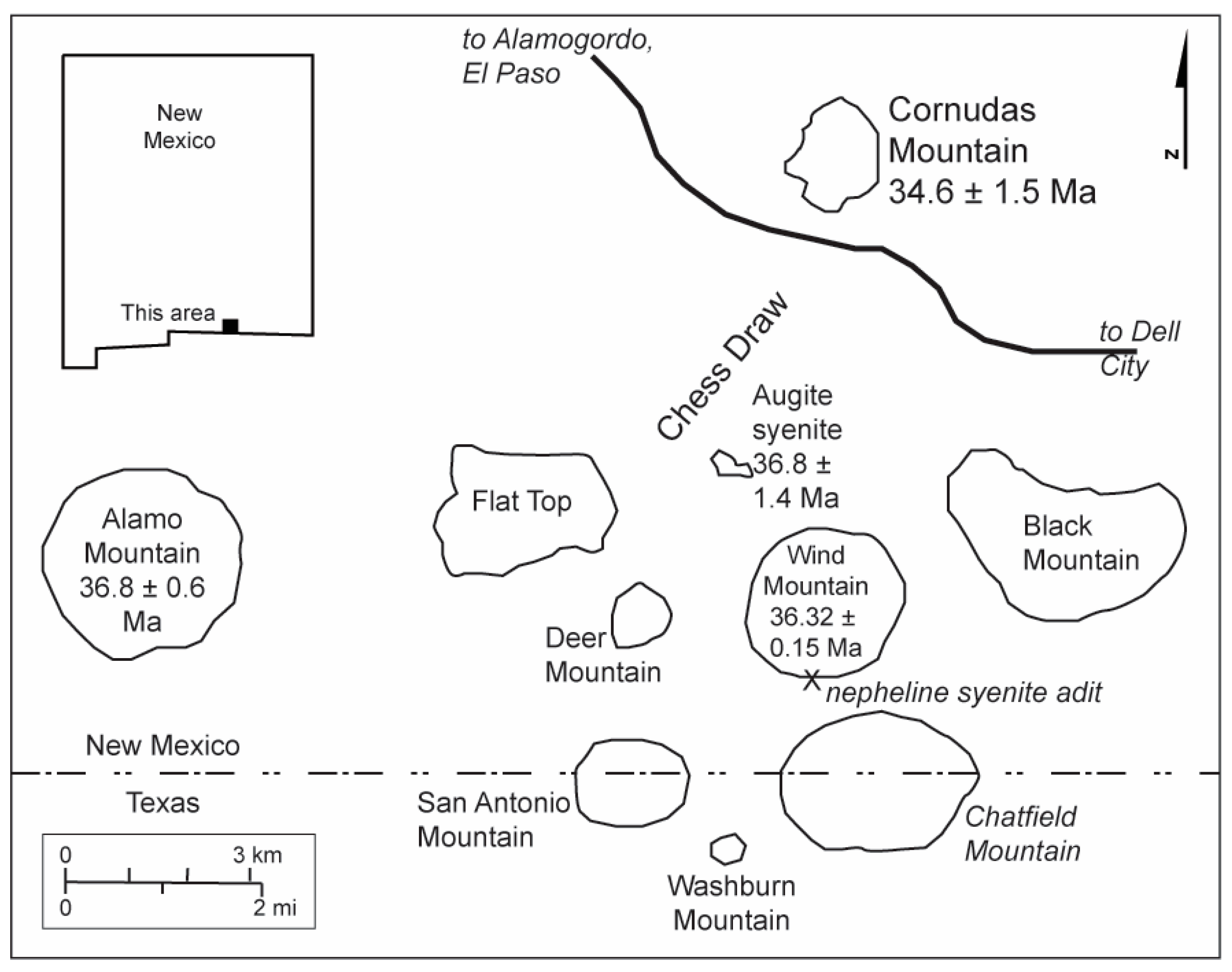
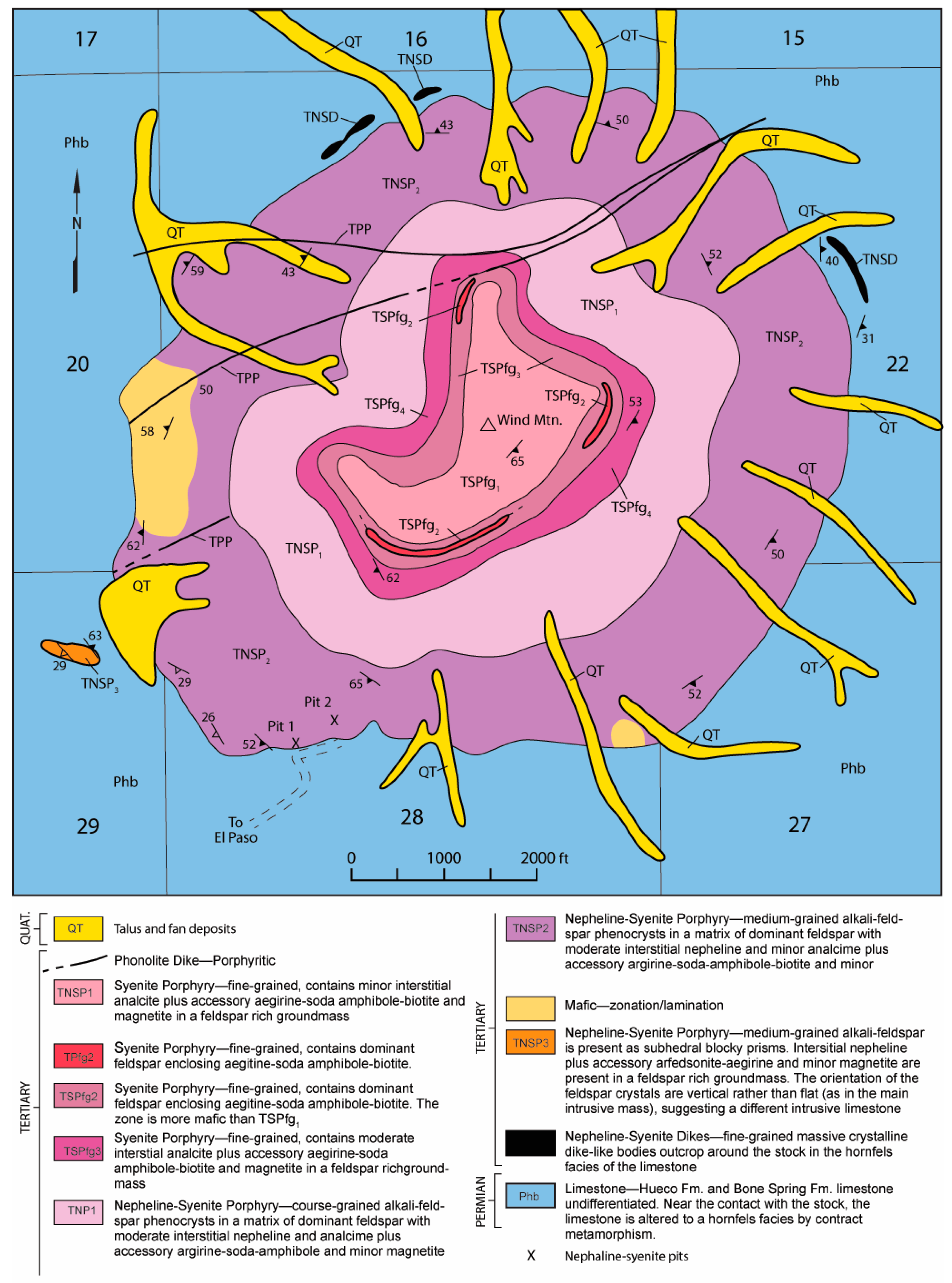
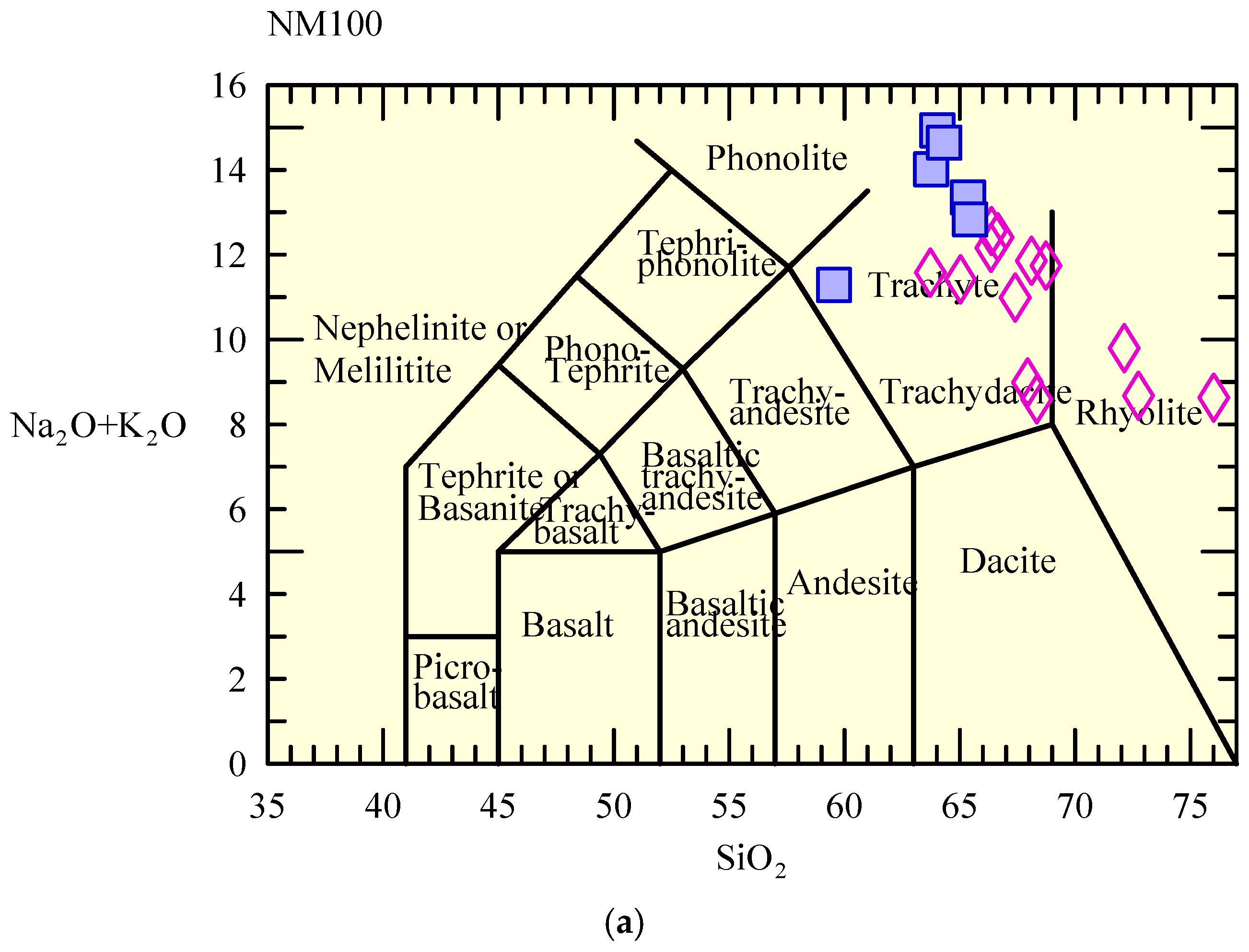
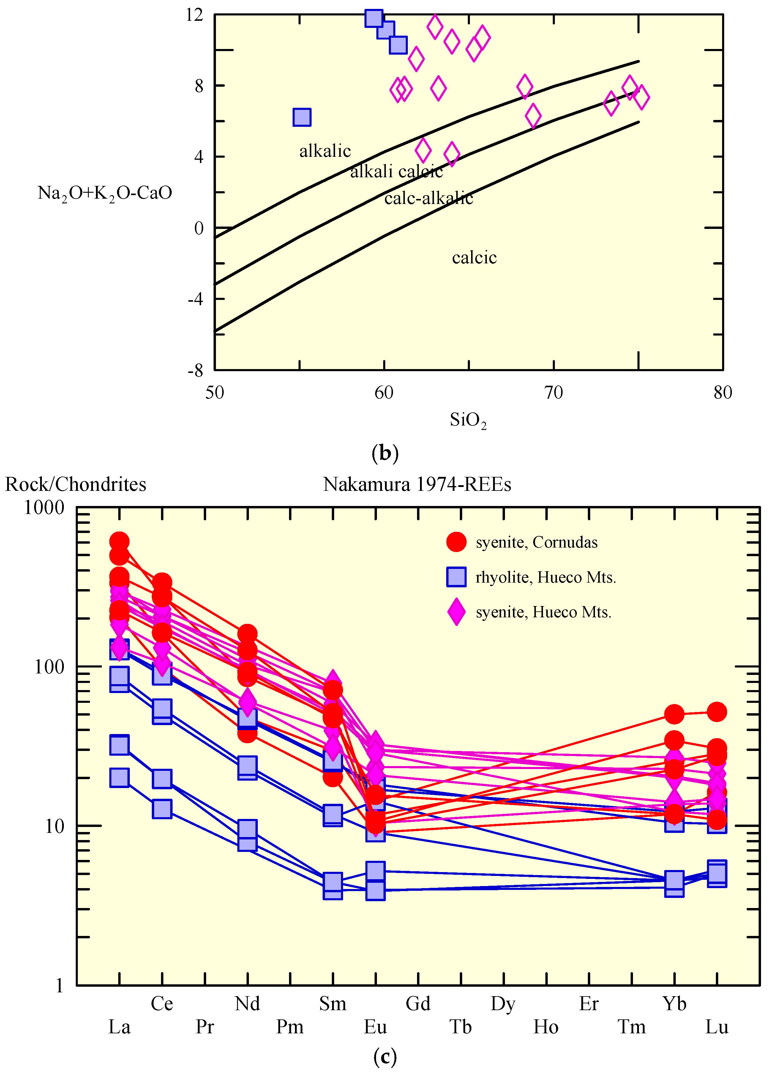
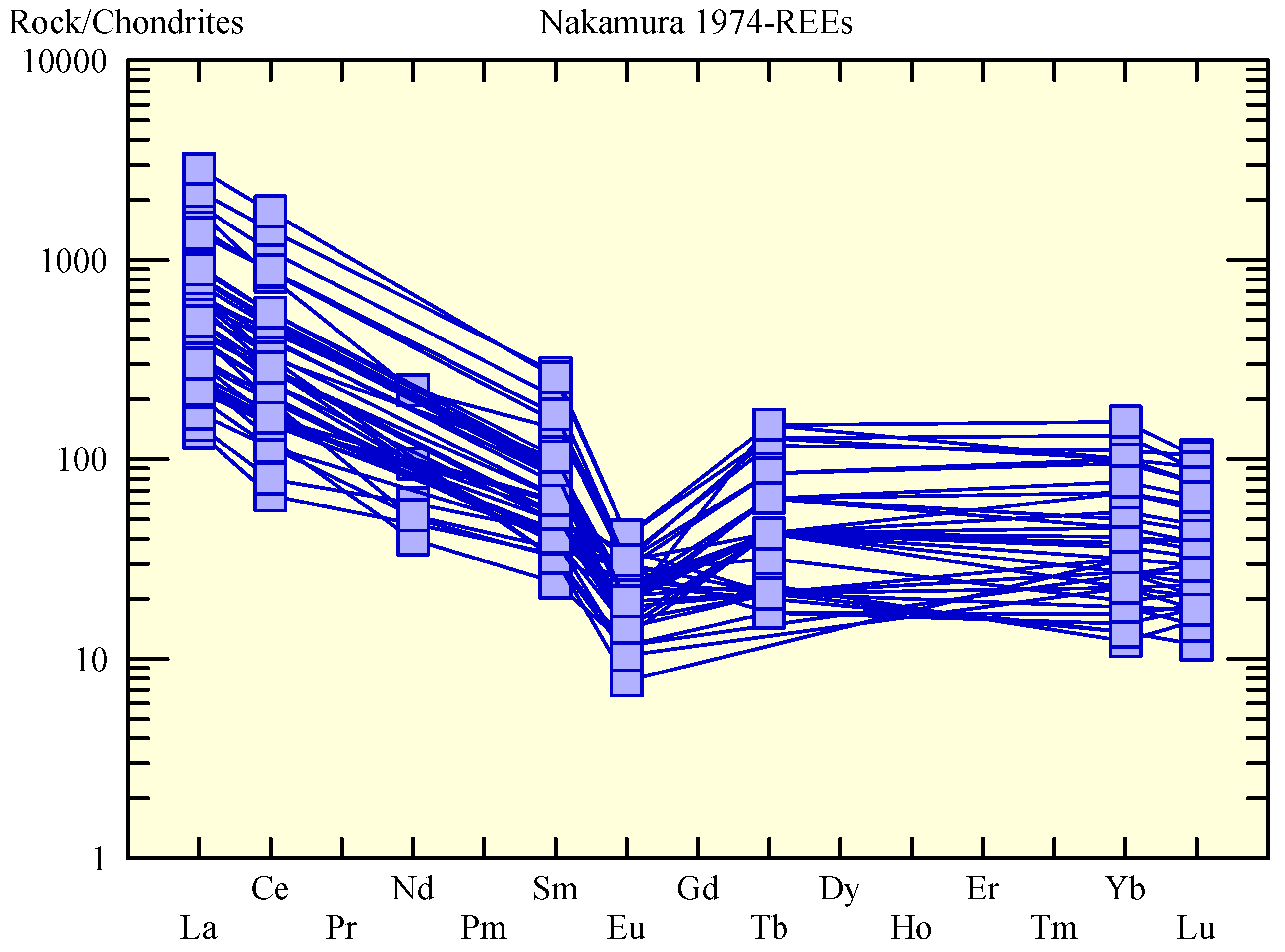
3.4. Cornudas Mountains District
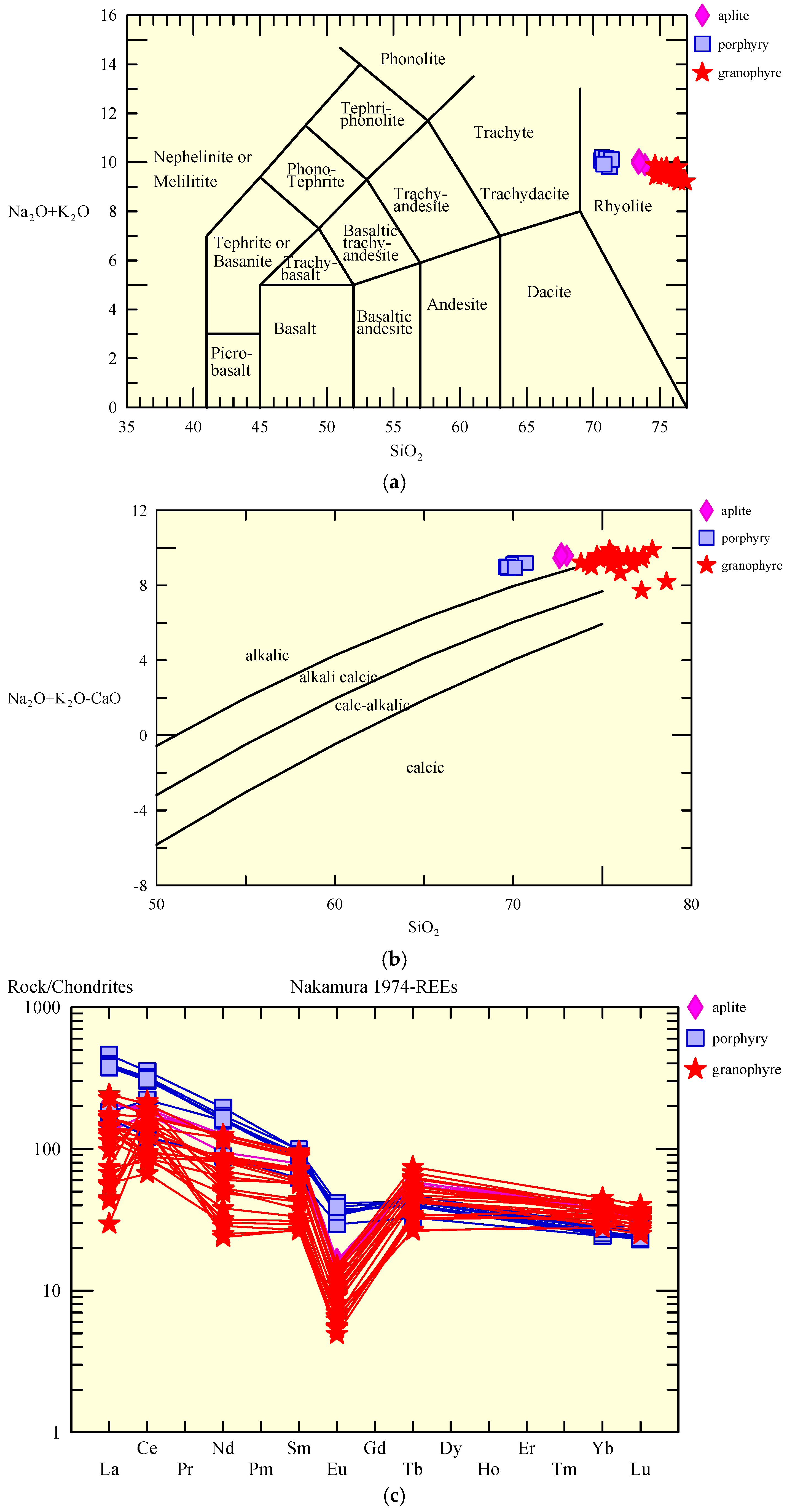
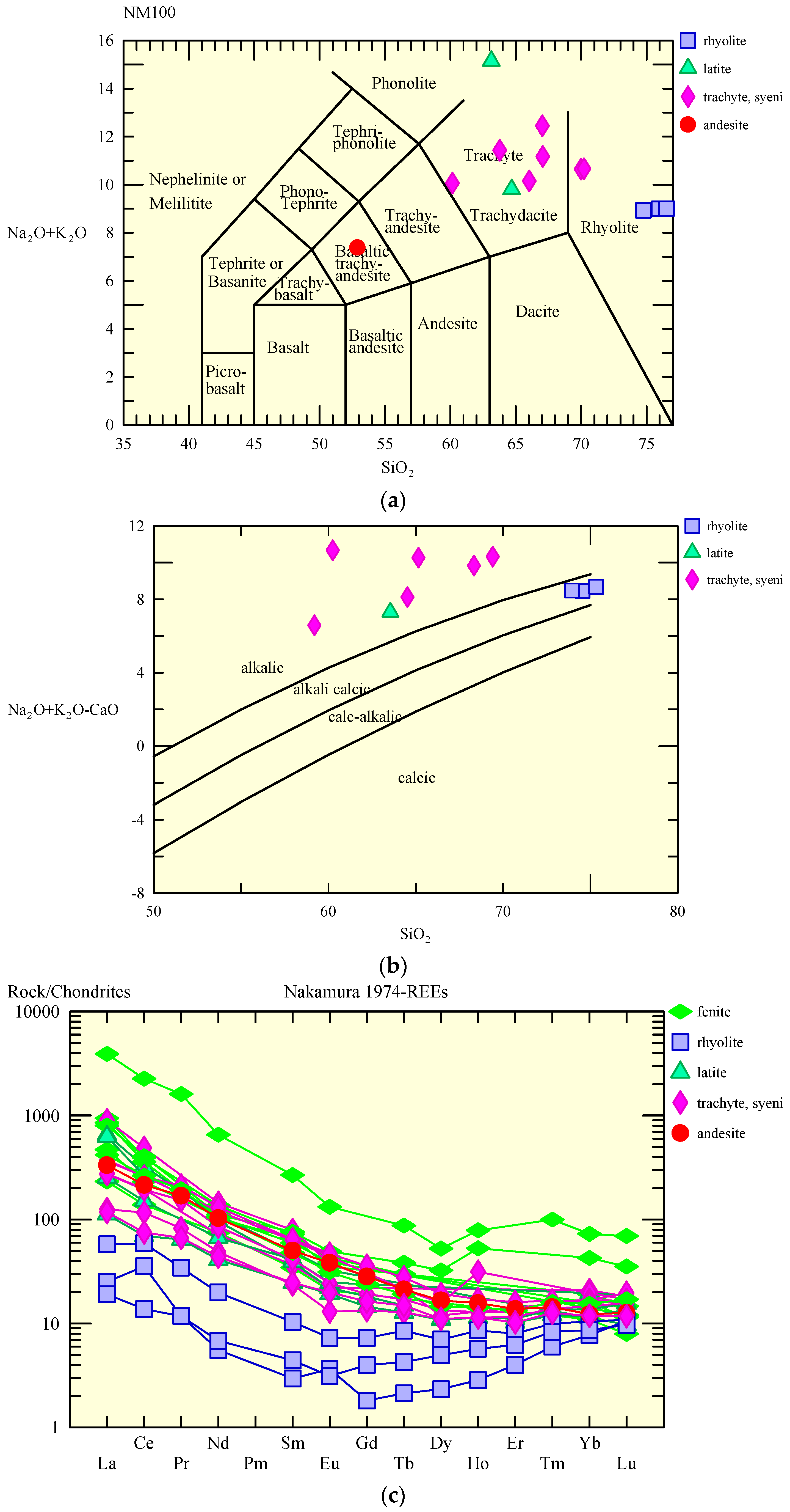
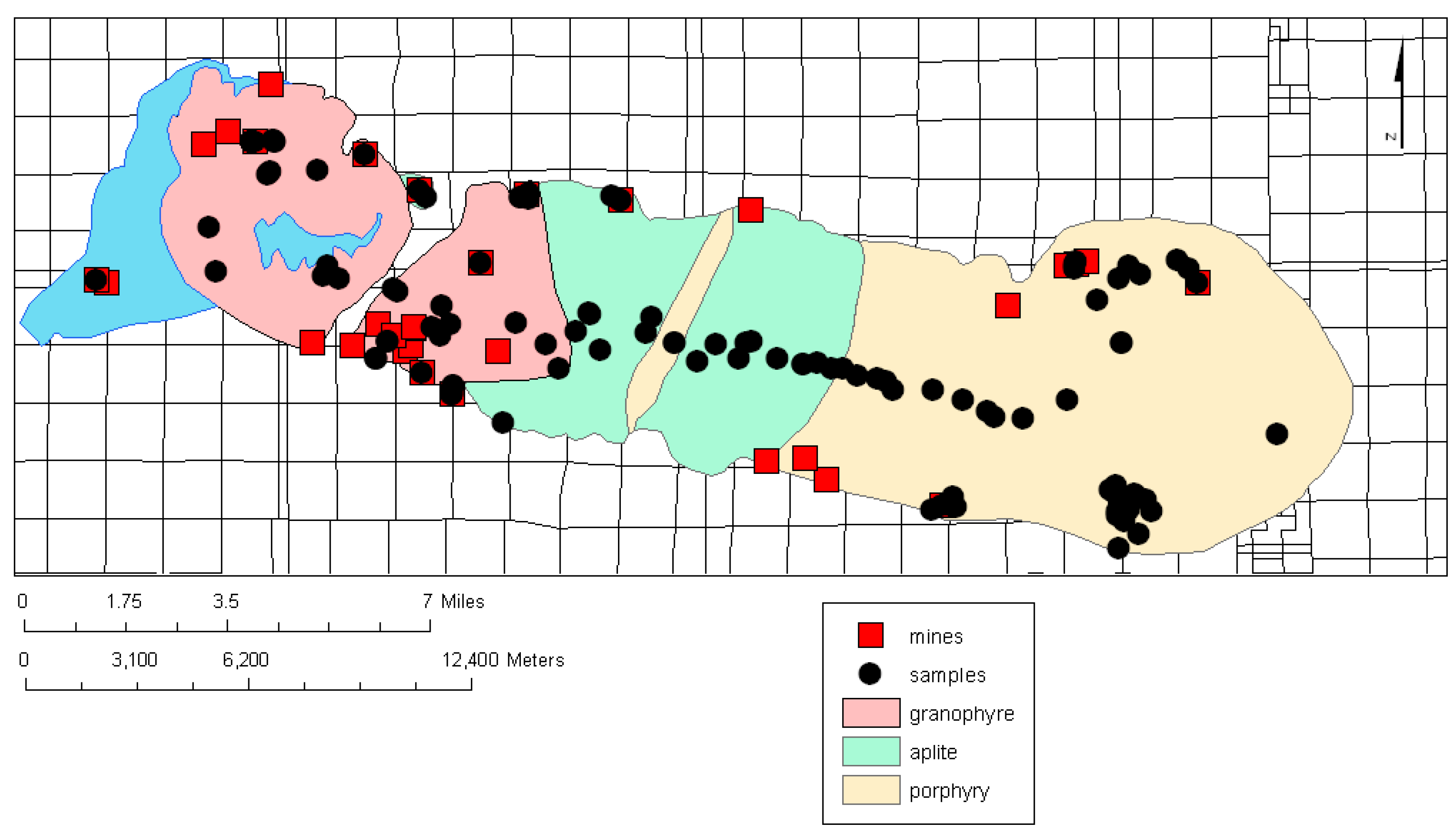
3.5. Sierra Blanca (Round Top Mountain)
3.6. Aguachile, Coahuila, Mexico
3.7. Villa Ahumada Carbonatites, Mexico
4. Discussion and Conclusions
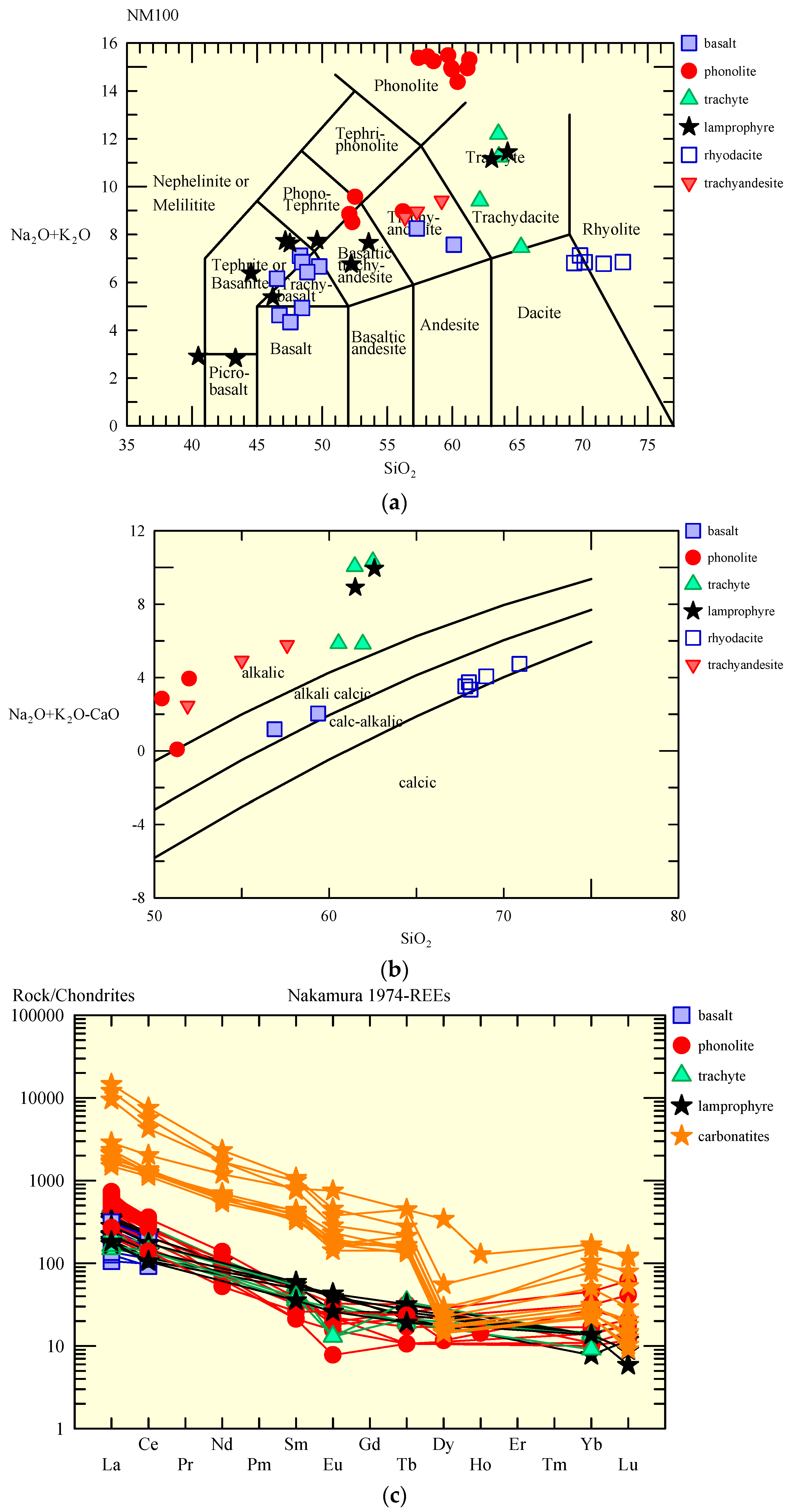
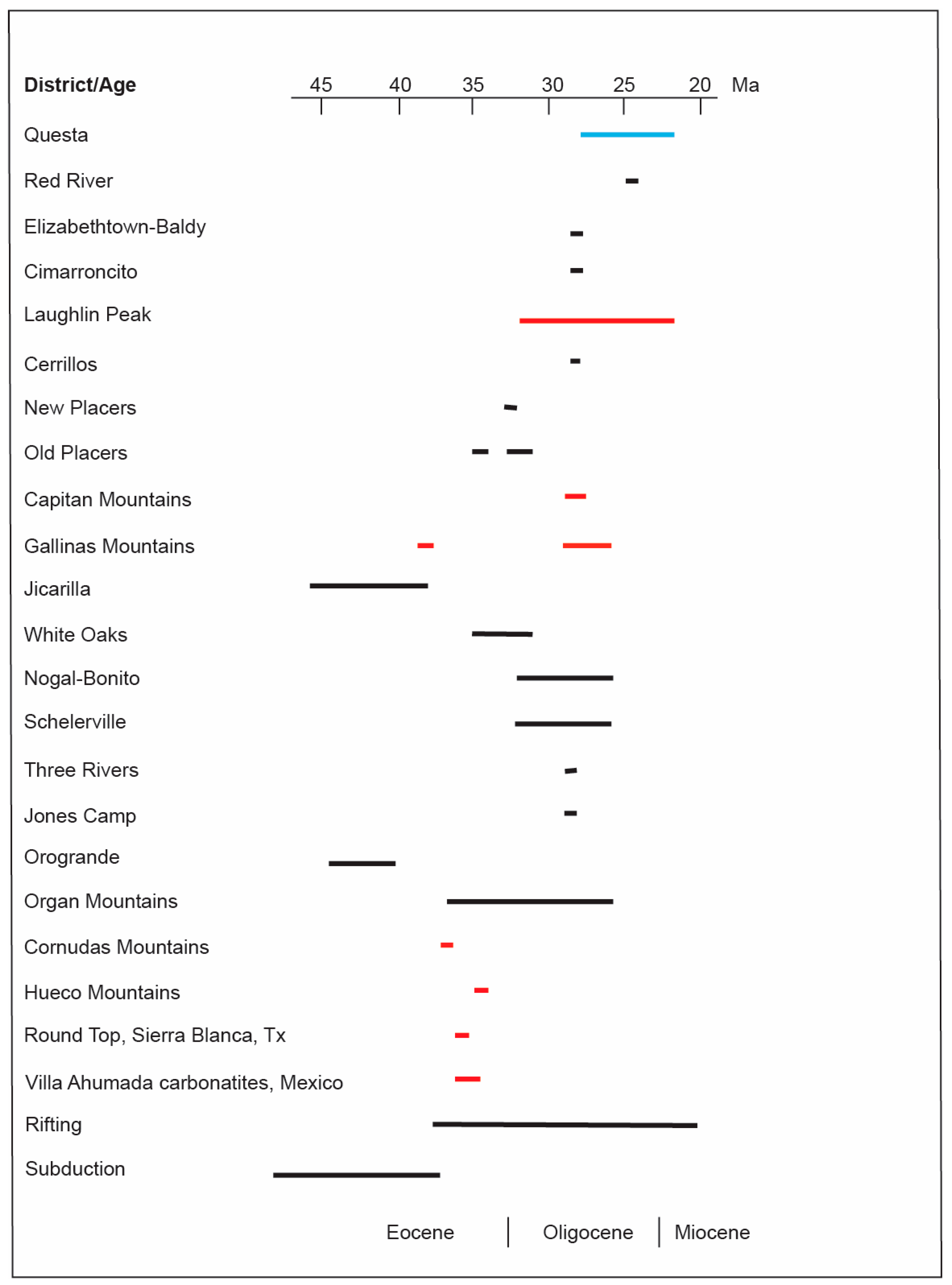
4.1. Age and Geochemistry of Associated Igneous Rocks
4.2. Geology, Geochemistry and Style of Mineralization of GPM Districts
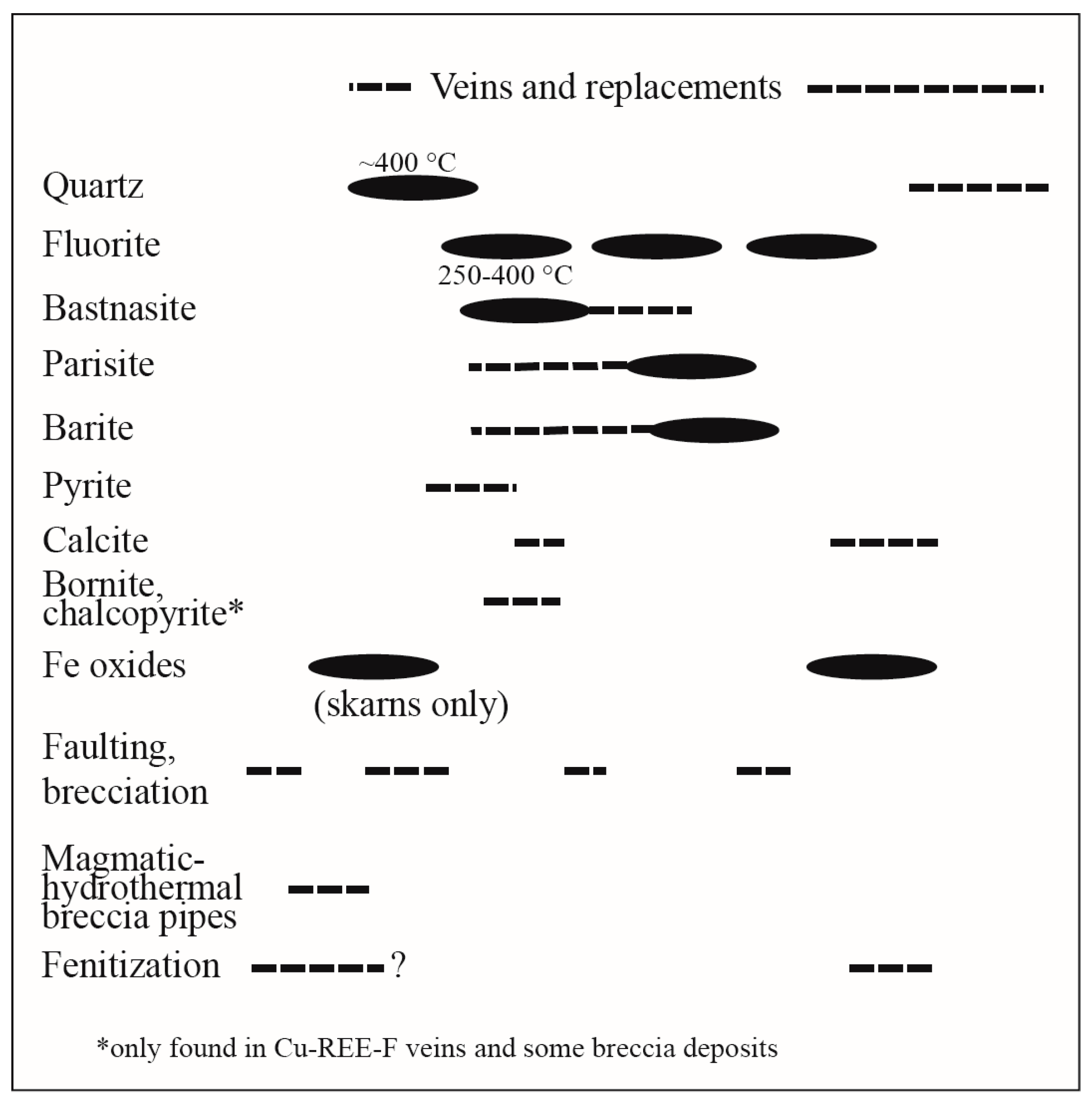
4.3. Origin of GPM Deposits
5. Resources and Future Exploration Potential
Supplementary Materials
Acknowledgments
Author Contributions
Conflicts of Interest
References
- Lindgren, W. Mineral Deposits, 4th ed.; McGraw-Hill: New York, NY, USA, 1913; 930p. [Google Scholar]
- Mutschler, F.E.; Griffin, M.E.; Stevens, D.S.; Shannon, S.S., Jr. Precious metal deposits related to alkaline rocks in the North American Cordillera—An interpretive review. Trans. Geol. Soc. Am. 1985, 88, 355–377. [Google Scholar]
- Mutschler, F.E.; Mooney, T.C.; Johnson, D.C. Precious metal deposits related to alkaline igneous rocks-a space-time trip through the Cordillera. Miner. Eng. 1991, 43, 304–309. [Google Scholar]
- McLemore, V.T. Tellurium Deposits in New Mexico: SME Annual Meeting Preprint 13-104. Littleton, CO, USA, 2013. Available online: http://geoinfo.nmt.edu/staff/mclemore/projects/mineralresources/documents/13-104.pdf (accessed on 20 January 2018).
- Kelley, K.D.; Sry, P.G. Critical Elements in Alkaline Igneous Rock-Related Epithermal Gold Deposits: Chapter 9 InRare Earth and Critical Elements in Ore Deposits; Reviews in Economic Geology 18; Verplanck, P.L., Hitzman, M.W., Eds.; Society of Economic Geologists: Littleton, CO, USA, 2016; pp. 195–216. [Google Scholar]
- Maehl, W.C. Zortman and Landusky with 20/20 Hindsight. 2000. Available online: https://fs.ogm.utah.gov/pub/MINES/AMR_Related/NAAMLP/EnDesign/Maehl.pdf (accessed on 20 January 2018).
- Millonig, L.J.; Groat, L.A. Carbonatites in western North America—Occurrences and metallogeny. In Tectonics, Metallogeny, and Discovery: The North American Cordillera and Similar Accretionary Settings; Special Publication 17; Colpron, M., Bissig, T., Rusk, B.G., Thompson, J.F.H., Eds.; Society of Economic Geologists: Littleton, CO, USA, 2013; pp. 245–264. [Google Scholar]
- Van Gosen, B.S.; Verplanck, P.L.; Seal, R.R., II; Long, K.R.; Gambogi, J. Rare-earth elements, chap. O. In Critical Mineral Resources of the United States—Economic and Environmental Geology and Prospects for Future Supply; U.S. Geological Survey Professional Paper 1802; Schulz, K.J., DeYoung, J.H., Jr., Seal, R.R., II, Bradley, D.C., Eds.; United States Geological Survey: Reston, VA, USA, 2017; pp. O1–O31. [Google Scholar]
- Du, X.; Graedel, T.E. Global in-use stocks of the rare earth elements: A first estimate. Environ. Sci. Technol. 2011, 45, 4096–4101. [Google Scholar] [CrossRef] [PubMed]
- Schulz, K.J.; De Young, J.H., Jr.; Bradley, D.C.; Seal, R.R., II. Critical mineral resources of the United States—An introduction, chap. A. In Critical Mineral Resources of the United States—Economic and Environmental Geology and Prospects for Future Supply; Professional Paper 1802; Schulz, K.J., DeYoung, J.H., Jr., Seal, R.R., II, Bradley, D.C., Eds.; U.S. Geological Survey: Reston, VA, USA, 2017; pp. A1–A14. [Google Scholar]
- Naumov, A.V. Review of the world market of rare-earth metals. Russ. J. Non-Ferrous Met. 2008, 49, 14–22. [Google Scholar]
- Committee on Critical Mineral Impacts of the U.S. Economy. Minerals, Critical Minerals, and the U.S. Economy: Committee on Earth Resources; National Research Council: Washington, DC, USA, 2008; 264p, ISBN 0-309-11283-4.
- Hedrick, J.B. Rare Earths (Advanced Release): 2007 Minerals Yearbook; U.S. Geological Survey: Reston, VA, USA, 2009; 20p. Available online: http://www.usmagneticmaterials.com/documents/USGS-RE-Minerals-Yearbook.pdf (accessed on 22 January 2018).
- Haxel, G.B.; Hedrick, J.B.; Orris, G.J. Rare Earth Elements—Critical Resources for High Technology; Fact Sheet; U.S. Geological Survey: Reston, VA, USA, 2002.
- Guyonnet, D.; Planchon, M.; Rollat, A.; Escalon, V.; Tuduri, J.; Charles, N.; Vaxelaire, S.; Didier, D.; Fargier, H. Material flow analysis applied to rare earth elements in Europe. J. Clean. Prod. 2015, 107, 215–228. [Google Scholar] [CrossRef]
- Chakhmouradian, A.R.; Wall, F. Rare earth elements: Minerals, mines, magnets (and more). Elements 2012, 8, 333–340. [Google Scholar] [CrossRef]
- McLemore, V.T.; North, R.M.; Leppert, S. Rare-earth elements (REE), niobium and thorium districts and occurrences in New Mexico. In New Mexico Bureau of Mines and Mineral Resources; Open-file Report OF-324; AGI: Harrisburg, PA, USA, 1988; 28p. [Google Scholar]
- McLemore, V.T.; North, R.M.; Leppert, S. Rare-earth elements (REE) in New Mexico. N. M. Geol. 1988, 10, 33–38. [Google Scholar]
- Long, K.R.; van Gosen, B.S.; Foley, N.K.; Cordier, D. The Principle Rare Earth Elements Deposits of the United States—A Summary of Domestic Deposits and a Global Perspective; Scientific Investigations Report 2010-5220; U.S. Geological Survey: Reston, VA, USA, 2010.
- Bonham, H.F., Jr. Models for volcanic-hosted epithermal precious metal deposits. In Bulk Mineable Precious Metal Deposits of the Western United States; Geological Society of Nevada: Reno, NV, USA, 1988; pp. 259–271. [Google Scholar]
- Thompson, T.B. Genesis of gold associated with alkaline igneous rocks (abstr.). Geol. Soc. Am. Abstr. Programs 1991, 23, 99–100. [Google Scholar]
- Richards, J.P. Magmas, fluids, and ore deposits. In Alkalic-Type Epithermal Gold Deposits—A Review; Short Course Series; Thompson, J.F.H., Ed.; Mineralogical Association of Canada: Québec City, QC, Canada, 1995; Volume 23, pp. 367–400. [Google Scholar]
- McLemore, V.T. Great Plains Margin (alkalic-related) gold deposits in New Mexico. In Geology and Ore Deposits of the American Cordillera; Cyner, A.R., Fahey, P.L., Eds.; Geological Society of Nevada: Reno/Sparks, NV, USA, 1996; pp. 935–950. [Google Scholar]
- McLemore, V.T. Great Plains Margin (alkaline-related) gold deposits in New Mexico: Twenty years later. In New Concepts and Discoveries, 2015 Symposium Volume; Geological Society of Nevada: Reno/Sparks, NV, USA, 2015; Volume II, pp. 1305–1328. [Google Scholar]
- Jensen, E.P.; Barton, M.D. Gold Deposits Related to Alkaline Magmatism; Society of Economic Geologists: Littleton, CO, USA, 2000; Volume 13, pp. 279–314. [Google Scholar]
- Kelley, K.D.; Luddington, S. Cripple creek and other alkaline-related gold deposits in the southern Rocky Mountains, USA: Influence of regional tectonics. Miner. Depos. 2002, 37, 38–60. [Google Scholar] [CrossRef]
- Chapin, C.E.; Kelley, S.A.; Cather, S.M. The Rocky Mountain front, southwestern USA. Geosphere 2014, 10, 1043–1060. [Google Scholar] [CrossRef]
- Potter, L.S. Chemical variation along strike in feldspathoidal rocks of the eastern alkali belt, Trans-Pecos magmatic province, Texas and New Mexico. Can. Miner. 1996, 34, 241–264. [Google Scholar]
- North, R.M.; McLemore, V.T. Silver and Gold Occurrences in New Mexico; Resource Map 15; Scale 1:1,000,000; New Mexico Bureau of Mines and Mineral Resources: Socorro, NM, USA, 1986; 32p. [Google Scholar]
- North, R.M.; McLemore, V.T. A Classification of the Precious Metal Deposits of New Mexico. In Bulk Mineable Precious Metal Deposits of the Western United States Symposium Volume, Proceedings of the Geological Society of Nevada, Reno, Nevada, 6–8 April 1987; Geological Society of Nevada: Reno/Sparks, NV, USA, 1988; pp. 625–660. [Google Scholar]
- McLemore, V.T. Silver and Gold Resources in New Mexico; Resource Map 21; New Mexico Bureau of Mines and Mineral Resources: Socorro, NM, USA, 2001; 60p. [Google Scholar]
- McLemore, V.T.; Lueth, V. Metallic Mineral Deposits. In Energy and Mineral Deposits in New Mexico; McLemore, V.T., Timmons, S., Wilks, M., Eds.; New Mexico Bureau of Geology and Mineral Resources Memoir 50 and New Mexico Geological Society Special Publication: Socorro, NM, USA, 2017; Volume 13, 79p. [Google Scholar]
- Cox, D.P.; Bagby, W.C. Descriptive models of Au-Ag-Te veins. In Mineral Deposit Models: U.S. Geological Survey, Bulletin 1693; Cox, D.P., Singer, D.A., Eds.; U.S. Geological Survey: Reston, VA, USA, 1986; p. 124. [Google Scholar]
- Bliss, J.D.; Sutphin, D.M.; Moiser, D.L.; Allen, M.S. Grade-tonnage and Target-area Models of Au-Ag-Te Veins Associated with Alkalic Rocks; OF 92-208; U.S. Geological Survey: Reston, VA, USA, 1992; 15p.
- Kelley, K.D.; Romberger, S.B.; Beaty, D.W.; Pontius, J.A.; Snee, L.W.; Stein, H.J.; Thompson, T.B. Geochemical and geochronological constraints on the genesis of Au-Te deposits at Cripple Creek, Colorado. Econ. Geol. 1998, 93, 981–1012. [Google Scholar] [CrossRef]
- Fulp, M.S.; Woodward, L.A. Mineral deposits of the New Mexico alkalic province (abstr.). Geol. Soc. Am. Abstr. Programs 1991, 23, 23. [Google Scholar]
- Fulp, M.S.; Woodward, L.A. The Mudpuppy-Waterdog Prospect, an Alkalic Copper-Gold Porphyry System in the NOGAL-Bonito Mining District; Guidebook 42; New Mexico Geological Society: Socorro, NM, USA, 1991; pp. 327–328. [Google Scholar]
- Thompson, T.B. The Bonito-Nogal district, Lincoln County, New Mexico (abstr.). Geol. Soc. Am. Bull. Abstr. Programs 1991, 23, 99. [Google Scholar]
- Cox, D.P.; Singer, D.A. (Eds.) Mineral Deposit Models; Bulletin 1693; U.S. Geological Survey: Reston, VA, USA, 1986; 379p.
- Rytuba, J.J.; Cox, D.P. Porphyry Gold: A Supplement to U.S. Geological Survey Bulletin 1693; Open-File Report 91-116; U.S. Geological Survey: Reston, VA, USA, 1991; 7p. Available online: http://pubs.usgs.gov/of/1991/0116/report.pdf (accessed on 20 January 2018).
- Verplanck, P.L.; Van Gosen, B.S.; Seal, R.R.; McCafferty, A.E. A Deposit Model for Carbonatite and Peralkaline Intrusion-Related Rare Earth Element Deposits: Chapter J in Mineral Deposit Models for Resource Assessment; Scientific Investigations Report 2010-5070-J; U.S. Geological Survey: Reston, VA, USA, 2014; 58p.
- Foley, N.K.; Hofstra, A.H.; Lindsey, D.A.; Seal, R.R., II; Jaskula, B.; Piatak, N.M. Occurrence model for volcanogenic beryllium deposits, chap. F. In Mineral Deposit Models for Resource Assessment; Scientific Investigations Report 2010-5070-F; U.S. Geological Survey: Reston, VA, USA, 2012; 43p. [Google Scholar]
- McLemore, V.T.; Zimmerer, M. Magmatic Activity and Mineralization along the Capitan; In Santa Rita, and Morenci Lineaments in the Chupadera Mesa Area, Central New Mexico. Guidebook 60; New Mexico Geological Society: Socorro, NM, USA, 2009; pp. 375–386. [Google Scholar]
- McLemore, V.T. Geology and Mineral Resources of the Laughlin Peak Mining District; Guidebook 66; New Mexico Geological Society: Socorro, NM, USA, 2015; pp. 277–288. [Google Scholar]
- McLemore, V.T.; Dunbar, N.; Heizler, L.; Heizler, M. Geology and Mineral Deposits of the Orogrande Mining District; Guidebook 65; New Mexico Geological Society: Socorro, NM, USA, 2014; pp. 247–259. [Google Scholar]
- McLemore, V.T.; Phillips, R.S. Geology of Mineralization and Associated Alteration in the Capitan Mountains; Guidebook 42; New Mexico Geological Society: Socorro, NM, USA, 1991; pp. 291–298. [Google Scholar]
- Nandigam, R. Geology and Geochemistry of Newly Discovered Tertiary Carbonatite Occurrences near Villa Ahumada Area, Basin and Range Province, Chihuahua, Northern Mexico. Ph.D. Thesis, University of Texas at El Paso, El Paso, TX, USA, 2000; 377p. [Google Scholar]
- McLemore, V.T. Rare Earth Elements Deposits in New Mexico. In Arizona Geological Survey Special Paper #9; Chapter 3, Proceedings of the 48th Annual Forum on the Geology of Industrial Minerals, Phoenix, Arizona, 30 April–4 May 2012; Conway, F.M., Ed.; 2014; pp. 1–16. Available online: http://repository.azgs.az.gov/uri_gin/azgs/dlio/1568 (accessed on 20 January 2018).
- Woolley, A.R. Alkaline Rocks and Carbonatites of the World, Part 1: North and South America; University of Texas Press: Austin, TX, USA, 1987. [Google Scholar]
- Chapin, C.E.; Jahns, R.H.; Chamberlin, R.M.; Osburn, G.R. First day road log from Socorro to Truth or Consequences via Magdalena and Winston. In Field Guild to Selected Caldrons and Mining Districts of the Datil-Mogollon Volcanic Field, New Mexico; Special Publication No. 7; New Mexico Geological Society: Socorro, NM, USA, 1978; pp. 17–19. [Google Scholar]
- Sims, P.K.; Stein, H.J.; Finn, C.A. New Mexico structural zone—An analogue of the Colorado mineral belt. Ore Geol. Rev. 2002, 21, 211–225. [Google Scholar] [CrossRef]
- Chapin, C.E.; Wilks, M.; McIntosh, W.C. Space-Time Patterns of Late Cretaceous to Present Magmatism in New Mexico; Comparison with Andean Volcanism and Potential for Future Volcanism; InTectonics, Geochronology and Volcanism in the Southern Rocky Mountains and Rio Grande rift: New Mexico Bureau of Geology and Mineral Resources; Bulletin 160; Socorro, NM, USA, 2004; pp. 13–40. Available online: http://geoinfo.nmt.edu/publications/monographs/bulletins/160/downloads/02chapin.pdf (accessed on 20 January 2018).
- McLemore, V.T.; Hoffman, G.; Smith, M.; Mansell, M.; Wilks, M. Mining Districts of New Mexico; Open-file Report [CD-ROM]; New Mexico Bureau of Mines and Mineral Resources: Socorro, NM, USA, 2005. [Google Scholar]
- McLemore, V.T.; Krueger, C.B.; Johnson, P.; Raugust, J.S.; Jones, G.E.; Hoffman, G.K.; Wilks, M. New Mexico Mines Database. Miner. Eng. 2005, 27, 42–49. [Google Scholar]
- File, L.; Northrop, S.A. County, Township, and Range Locations of New Mexico’s Mining Districts; Circular 84; New Mexico Bureau of Mines and Mineral Resources: Socorro, NM, USA, 1966; 66p. [Google Scholar]
- Irvine, T.N.; Baragar, W.R.A. A guide to the chemical classification of the common volcanic rocks. Can. J. Earth Sci. 1971, 8, 523–548. [Google Scholar] [CrossRef]
- Pearce, J.A.; Harris, N.B.W.; Tindle, A.G. Trace element discrimination diagrams for the tectonic interpretation of granitic rocks. J. Petrol. 1984, 24, 956–983. [Google Scholar] [CrossRef]
- Frost, B.D.; Barnes, C.G.; Collins, W.J.; Arculus, R.J.; Ellis, D.J.; Frost, C.D. A geochemical classification for granitic rocks. J. Petrol. 2001, 42, 2033–2048. [Google Scholar] [CrossRef]
- Frost, B.D.; Frost, C.D. A geochemical classification for feldspathic igneous rocks. J. Petrol. 2008, 49, 1955–1969. [Google Scholar] [CrossRef]
- Schandl, E.S.; Gorton, M.P. Application of high field strength elements to discriminate tectonic settings in VMS environments. Econ. Geol. 2002, 97, 629–642. [Google Scholar] [CrossRef]
- Whalen, J.B.; Currie, K.L.; Chappell, B.W. A-Type granites: Geochemical characteristics, discrimination and petrogenesis. Contrib. Miner. Petrol. 1987, 95, 407–419. [Google Scholar] [CrossRef]
- McLemore, V.T. Mining Districts and Prospect Areas of New Mexico; Resource Map 24; Scale 1:1,000,000; New Mexico Bureau of Geology and Mineral Resources: Socorro, NM, USA, 2017; 65p. [Google Scholar]
- Lipman, P.W. Incremental assembly and prolonged consolidation of Cordilleran magma chambers: Evidence from the Southern Rocky Mountain volcanic field. Geosphere 2007, 3, 42–70. [Google Scholar] [CrossRef]
- Laughlin, A.W.; Rehrig, W.A.; Mauger, R.L. K-Ar chronology and sulfur and strontium isotope ratios at the Questa mine, New Mexico. Econ. Geol. 1969, 64, 903–909. [Google Scholar] [CrossRef]
- Dillet, B.; Czamanske, G.K. Aspects of the Petrology, Mineralogy, and Geochemistry of the Granitic Rocks Associated with Questa Caldera, Northern New Mexico; Open-File Report 87-0258; U.S. Geological Survey: Reston, VA, USA, 1987; 238p.
- Johnson, C.M.; Czamanske, G.K.; Lipman, P.W. Geochemistry of intrusive rocks associated with the Latir volcanic field, New Mexico, and contrasts between evolution of plutonic and volcanic rocks. J. Contrib. Miner. Petrol. 1989, 103, 90–109. [Google Scholar] [CrossRef]
- Czamanske, G.K.; Allen, J.C. The 40Ar/39Ar Chronology of Caldera Formation, Intrusive Activity and Mo-Ore Deposition Near Questa, New Mexico; InTectonic Development of the Southern Sangre de Cristo Mountains, New Mexico; Guidebook 41; Bauer, P.W., Lucas, S.G., Mawer, C.K., McIntosh, W.C., Eds.; New Mexico Geological Society: Socorro, NM, USA, 1990; pp. 355–358. [Google Scholar]
- Ross, P.S.; Jebrak, M.; Walker, B.M. Discharge of hydrothermal fluids from a magma chamber and concomitant formation of a stratified breccia zone at the Questa porphyry molybdenum deposit, New Mexico. Econ. Geol. 2002, 97, 1679–1699. [Google Scholar] [CrossRef]
- McLemore, V.T. Geologic Setting and Mining History of the Questa Mine; Open-file report 515; New Mexico Bureau of Geology and Mineral Resources: Socorro, NM, USA, 2009; 29p. [Google Scholar]
- Rowe, A. Ore Genesis and Fluid Evolution of the Goat Hill Orebody, Questa Climax-Type Porphyry-Mo System, New Mexico and Its Comparison to the Climax-Type Deposits of the Colorado Mineral Belt. Ph.D. Thesis, New Mexico Institute Mining Technology, Socorro, NM, USA, 2012; 286p. [Google Scholar]
- Zimmerer, M.J.; McIntosh, W.C. The geochronology of volcanic and plutonic rocks at the Questa caldera: Constraints on the origin of caldera-related silicic magmas. Geol. Soc. Am. 2012, 124, 1394–1408. [Google Scholar] [CrossRef]
- Roberts, T.T.; Parkison, G.A.; McLemore, V.T. Geology of the Red River District, Taos County, New Mexico; Guidebook 41; New Mexico Geological Society: Socorro, NM, USA, 1990; pp. 375–380. [Google Scholar]
- Lindgren, W.; Graton, L.C.; Gordon, C.H. The Ore Deposits of New Mexico; Professional Paper 68; U.S. Geological Survey: Reston, VA, USA, 1910; 361p.
- Lee, W.T. The Aztec Gold Mine, Baldy, New Mexico; Bulletin 620; U.S. Geological Survey: Reston, VA, USA, 1916; pp. 325–330.
- Pettit, R.F. Mineral Resources of Colfax County, New Mexico; Open-file Report 15; New Mexico Bureau of Mines and Mineral Resources: Socorro, NM, USA, 1946; 73p. [Google Scholar]
- Pearson, J.B. A New Mexico Gold Story—The Elizabethtown-Red River area. Ph.D. Thesis, University Texas, Austin, TX, USA, 1955; pp. 1–534. [Google Scholar]
- Kish, S.A.; Ragland, P.C.; Cannon, R.P. Petrochemistry of the Palisades sheet, Cimarron Pluton, Northern New Mexico; Guidebook 41; New Mexico Geological Society: Socorro, NM, USA, 1990; pp. 341–347. [Google Scholar]
- Staatz, M.H. Geology and Description of the Thorium and Rare-Earth Veins in the Laughlin Peak Area, Colfax County, New Mexico; Professional Paper 1049-E; U.S. Geological Survey: Reston, VA, USA, 1985; 32p.
- Staatz, M.H. Geologic Map of the Pine Buttes Quadrangle, Colfax County, New Mexico; Quadrangle Map GQ-1591; Scale 1:24,000; U.S. Geological Survey: Reston, VA, USA, 1986.
- Staatz, M.H. Geologic Map of the Tres Hermanos Peak Quadrangle, Colfax County, New Mexico; Quadrangle Map GQ-1605; Scale 1:24,000; U.S. Geological Survey: Reston, VA, USA, 1987.
- Potter, L.S. Petrology and Petrogenesis of Tertiary Igneous Rocks, Chico Hills, New Mexico. Master’s Thesis, Iowa State University, Ames, IA, USA, 1988; 179p. [Google Scholar]
- Schreiner, R.A. Preliminary Investigations of Rare-Earth-Element-Bearing Veins, Breccias, and Carbonatites in the Laughlin Peak Area, Colfax County, New Mexico; U.S. Bureau of Mines: Washington, DC, USA, 1991; pp. 93–99.
- Stroud, J.R. The Geochronology of the Raton-Clayton Volcanic Field, with Implications for Volcanic History and Landscape Evolution. Master’s Thesis, New Mexico Institute of Mining and Technology, Socorro, NM, USA, 1997; pp. 1–70. [Google Scholar]
- Wargo, J.G. Geology of a disseminated copper deposit near Cerrillos, New Mexico. Econ. Geol. 1964, 59, 1525–1538. [Google Scholar] [CrossRef]
- Giles, D.L. Gold mineralization in the Cerrillos district, New Mexico (abstr.). Geol. Soc. Am. Abstr. Programs 1991, 23, 24. [Google Scholar]
- Sauer, R.R. Petrochemistry and Geochronology of Plutons Relative to Tectonics in the San Pedro-Ortiz Porphyry Belt, New Mexico. Master’s Thesis, University Colorado, Boulder, CO, USA, 1994; 115p. [Google Scholar]
- Maynard, S.R. Geology and Mineral Resources of the Ortiz Mine Grant, Santa Fe County, New Mexico; Open-File Report 560; New Mexico Bureau of Geology and Mineral Resources: Socorro, NM, USA, 2014; 178p. [Google Scholar]
- Kay, B.D. Vein and Breccia Gold Mineralization and Associated Igneous Rocks at the Ortiz Mine, New Mexic, USA. Master’s Thesis, Colorado School of Mines, Golden, CO, USA, 1986; 179p. [Google Scholar]
- Maynard, S.R.; Martin, K.W.; Nelson, C.J.; Schutz, J.L. Geology and Gold Mineralization of the Ortiz Mountains, Santa Fe County, New Mexico; Preprint No. 89-43; Society of Mining, Metallurgy and Exploration: Littleton, CO, USA, 1989; 9p. [Google Scholar]
- Maynard, S.R.; Nelson, C.J.; Martin, K.W.; Schutz, J.L. Geology and gold mineralization of the Ortiz Mountains, Santa Fe County, New Mexico. Miner. Eng. 1990, 42, 1007–1011. [Google Scholar]
- Schutz, J.L. Gold Mineralization Associated with Alkaline Intrusives at the Carache Canyon Breccia Pipe Prospect, Ortiz Mountains, New Mexico; Guidebook 46; New Mexico Geological Society: Socorro, NM, USA, 1995; pp. 167–173. [Google Scholar]
- Kelley, V.C. Geology and Economics of New Mexico Iron Ore Deposits; University of New Mexico, Publications in Geology: Albuquerque, NM, USA, 1949; 246p. [Google Scholar]
- McLemore, V.T. Preliminary Report on the Geology and Mineral-Resource Potential of Torrance County, New Mexico; OF-192; New Mexico Bureau of Mines and Mineral Resources: Socorro, NM, USA, 1984; 211p. [Google Scholar]
- Griswold, G.B. Mineral Deposits of Lincoln County, New Mexico; Bulletin 67; New Mexico Bureau of Mines and Mineral Resources: Socorro, NM, USA, 1959; pp. 1–117. [Google Scholar]
- Glass, J.J.; Smalley, R.G. Bastnaesite (Gallinas Mountains, New Mexico). Am. Miner. 1945, 30, 601–615. [Google Scholar]
- Kelley, V.C.; Rothrock, H.E.; Smalley, R.G. Geology and Mineral Deposits of the Gallinas District, Lincoln County, New Mexico; Strategic Minerals Investigation Preliminary Map 3-211; Scale 1:62,500; U.S. Geological Survey: Reston, VA, USA, 1946.
- Soulé, J.H. Exploration of Gallinas Fluorspar Deposits, Lincoln County, New Mexico; Report of Investigations 3854; U.S. Bureau of Mines: Washington, DC, USA, 1946; 25p.
- Perhac, R.M. Geology and Mineral Deposits of the Gallinas Mountains, New Mexico. Ph.D. Thesis, University of Michigan, Ann Arbor, Michigan, 1961; 224p. Unpublished. [Google Scholar]
- Perhac, R.M. Geology and Mineral Deposits of the Gallinas Mountains, Lincoln and Torrance Counties, New Mexico; Bulletin 95; New Mexico Bureau of Mines and Mineral Resources: Socorro, NM, USA, 1970; 51p. [Google Scholar]
- Perhac, R.M.; Heinrich, E.W. Fluorite-bastnaesite deposits of the Gallinas Mountains, New Mexico and bastnaesite paragenesis. Econ. Geol. 1964, 59, 226–239. [Google Scholar] [CrossRef]
- DeMark, R.S. The Red Cloud mines, Gallinas Mountains, New Mexico. Miner. Rec. 1980, 11, 69–72. [Google Scholar]
- Korzeb, S.L.; Kness, R.F. Mineral Resource Investigation of the Roswell Resource Area, Chavez, Curry, DeBaca, Guadalupe, Lincoln, Quay and Roosevelt Counties, New Mexico; Open-file Report MLA 12-92; U.S. Bureau of Mines: Washington, DC, USA, 1992; 220p.
- Woodward, L.A.; Fulp, M.S. Gold Mineralization Associated with Alkali Trachyte Breccias in the Gallinas Mining District, Lincoln County, New Mexico; Guidebook 42; New Mexico Geological Society: Socorro, NM, USA, 1991; pp. 323–325. [Google Scholar]
- Schreiner, R.A. Mineral Investigation of the Rare-Earth-Element-Bearing Deposits, Red Cloud Mining District, Gallinas Mountains, Lincoln County, New Mexico; Open-file Report 2-91; U.S. Bureau of Mines: Washington, DC, USA, 1993; 62p.
- Jackson, W.D.; Christiansen, G. International Strategic Minerals Inventory Summary Report—Rare-Earth Oxides; Circular 930-N; U.S. Geological Survey: Reston, VA, USA, 1993; 76p.
- Williams-Jones, A.E.; Samson, I.M.; Olivo, G.R. The genesis of hydrothermal fluorite-REE deposits in the Gallinas Mountains, New Mexico. Econ. Geol. 2000, 95, 327–341. [Google Scholar] [CrossRef]
- Gagnon, J.E.; Samson, I.M.; Fryer, B.J.; Williams-Jones, A.E. Compositional heterogeneity in fluorite and the genesis of fluorite deposits: Insights from LA-ICP-Ms analysis. Can. Miner. 2003, 41, 365–382. [Google Scholar] [CrossRef]
- McLemore, V.T. Geology and Mineral Deposits of the Gallinas Mountains, Lincoln and Torrance Counties, New Mexico; Preliminary Report; Open-File Report OF-532; New Mexico Bureau of Geology and Mineral Resources: Socorro, NM, USA, 2010; 92p. [Google Scholar]
- Vance, Z. Mineralogy, Geochemistry and Genesis of the Hydrothermal REE-Fluorite-Ag-Pb-Cu Ore Deposits of the Gallinas Mountains, New Mexico. Master’s Thesis, New Mexico Institute of Mining and Technology, Socorro, NM, USA, 2013; 219p. [Google Scholar]
- Robison, A. 40Ar/39Ar Geochronology of Magmatism and Alteration in the Gallinas Mountains with Implications for Rare Earth Mineralization. Master’s Thesis, New Mexico Institute of Mining and Technology, Socorro, NM, USA, 2017; 177p. [Google Scholar]
- Robison, A.; McIntosh, W.; Lueth, V.W. 40Ar/39Ar geochronology of magmatism and alteration in the Gallinas Mountains with implications for rare earth mineralization. In New Mexico Geological Society, Annual Spring Meeting, 7 April 2017; Macey Center, New Mexico Institute Mining Technology: Socorro, NM, USA, 2017; p. 61. Available online: http://nmgs.nmt.edu/meeting/abstracts/view.cfm?aid=540 (accessed on 20 January 2018).
- Rawson, D.E. Geology of the Tecolote Hills Area, Lincoln County, New Mexico. Master’s Thesis, University New Mexico, Albuquerque, NM, USA, 1957; 77p. [Google Scholar]
- Segerstrom, K.; Ryberg, G.C. Geology and Placer-Gold Deposits of the Jicarilla Mountains, Lincoln County, New Mexico; Bulletin 1308; U.S. Geological Survey: Reston, VA, USA, 1974; 25p.
- McLemore, V.T.; Ouimette, M.; Eveleth, R.W. Preliminary Observations on the Mining History, Geology and Mineralization of the Jicarilla Mining District, Lincoln County, New Mexico; Guidebook 42; New Mexico Geological Society: Socorro, NM, USA, 1991; pp. 311–316. [Google Scholar]
- Grainger, J.R. Geology of the White Oaks Mining District, Lincoln County, New Mexico. Master’s Thesis, University New Mexico, Albuquerque, NM, USA, 1974; 69p. [Google Scholar]
- Ronkos, C.J. Geology, alteration, and gold mineralization in the White Oaks mining district, Lincoln County, New Mexico (abstr.). Geol. Soc. Am. Abstr. Programs 1991, 23, 88. [Google Scholar]
- Koning, D.J.; Kempter, K. Preliminary Geologic Map of the Carrizozo East 7.5-Minute Quadrangle, Lincoln County, New Mexico; Open-File Geologic Map 216; Scale 1:24,000; New Mexico Bureau of Geology and Mineral Resources: Socorro, NM, USA, 2010. [Google Scholar]
- Rawling, G.; Koning, D. Geologic Map of the White Oaks South Quadrangle, Lincoln County, New Mexico; Open-File Geologic Map, OF-GM 216; Scale 1:24,000; New Mexico Bureau of Geology and Mineral Resources: Socorro, NM, USA, 2011. [Google Scholar]
- Tuftin, S.E. Mineral Investigation of the Capitan Mountains Wilderness Area, Lincoln County, New Mexico; Open-File Report; MLA-20-84; U.S. Bureau Mines: Washington, DC, USA, 1984; 24p.
- Willis, M.; Campbell, A.; Phillips, R. High salinity fluids associated with allanite mineralization, Capitan Mountains, New Mexico. Geol. Soc. Am. Abstr. Programs 1989, 21, A287. [Google Scholar]
- Phillips, R.S. Geochemistry of Hydrothermal Th-U-REE Quartz/Fluorite Veins from the Capitan Pluton. Master’s Thesis, New Mexico Institute of Mining and Technology, Socorro, NM, USA, 1990; 202p. [Google Scholar]
- Phillips, R.S.; Campbell, A.R.; McLemore, V.T. Th-U-REE Quartz-Fluorite Veins, Capitan Pluton, New Mexico: Evidence for a Magmatic-Hydrothermal Origin; Guidebook 42; New Mexico Geological Society: Socorro, NM, USA, 1991; pp. 129–136. [Google Scholar]
- Banks, D.A.; Yardley, B.W.D.; Campbell, A.R.; Jarvis, K.E. REE composition of an aqueous magmatic fluid: A fluid inclusion study from the Capitan pluton, New Mexico, USA. Chem. Geol. 1994, 113, 259–272. [Google Scholar] [CrossRef]
- Allen, M.S.; McLemore, V.T. The Geology and Petrogenesis of the Capitan Pluton, New Mexico. In Geology of the Sierra Blanca, Sacramento, and Capitan Ranges, New Mexico: New Mexico Geological Society, 42nd Annual Field Conference, Guidebook; Barker, J.M., Kues, B.S., Austin, G.S., Lucas, S.G., Eds.; New Mexico Geological Society: Socorro, NM, USA, 1991; pp. 115–127. [Google Scholar]
- Allen, M.S.; Foord, E.E. Geological, geochemical and isotopic characteristics of the Lincoln County porphyry belt, New Mexico: Implications for regional tectonics and mineral deposits. In Geology of the Sierra Blanca, Sacramento, and Capitan Ranges, New Mexico: New Mexico Geological Society, 42nd Annual Field Conference, Guidebook; Barker, J.M., Kues, B.S., Austin, G.S., Lucas, S.G., Eds.; New Mexico Geological Society: Socorro, NM, USA, 1991; pp. 97–113. [Google Scholar]
- Campbell, A.R.; Banks, D.A.; Phillips, R.S.; Yardley, B.W.D. Geochemistry of the Th-U-REE mineralizing fluid, Capitan Mountains, New Mexico, USA. Econ. Geol. 1995, 90, 1273–1289. [Google Scholar] [CrossRef]
- Ratajeski, K.; Campbell, A.R. Distribution of fluid inclusions in igneous quartz of the Capitan Pluton, New Mexico, USA. Geochim. Cosmochim. Acta. 1994, 58, 1161–1174. [Google Scholar] [CrossRef]
- Dunbar, N.W.; Campbell, A.R.; Candela, P.A. Physical, chemical, and mineralogical evidence for magmatic fluid migration within the Capitan pluton, southeastern New Mexico. Geol. Soc. Am. Bull. 1996, 108, 318–333. [Google Scholar] [CrossRef]
- Rawling, G.C. Geology of the Capitan and Nogal Quadrangles, Lincoln County, New Mexico; Open-File Report 538; Scale 1:24,000; New Mexico Bureau of Geology and Mineral Resources: Socorro, NM, USA, 2011. [Google Scholar]
- Griswold, G.B.; Missaghi, F. Geology and Geochemical Survey of a Molybdenum Deposit near Nogal Peak, Lincoln County, New Mexico; New Mexico Bureau of Mines and Mineral Resources Campus Station: Socorro, NM, USA, 1964; Volume 67, p. 29. [Google Scholar]
- Giles, D.L.; Thompson, T.B. Petrology and mineralization of a molybdenum-bearing alkalic stock, Sierra Blanca, New Mexico. Geol. Soc. Am. Bull. 1972, 83, 2129–2148. [Google Scholar] [CrossRef]
- Gander, M.J. The Geology of the Northern Part of the Rialto Stock, Sierra Blanca Igneous Complex, New Mexico. Master’s Thesis, Colorado State University, Fort Collins, CO, USA, 1982; 132p. [Google Scholar]
- Briggs, J.P. Mineral Investigation of an Addition to the White Mountain Wilderness, Lincoln County, New Mexico; MLA-33-83; U.S. Bureau of Mines: Washington, DC, USA, 1983; 11p.
- Ryberg, G.E. Geology of the Vera Cruz Mine and Breccia Pipe, Lincoln County, New Mexico; Guidebook 42; New Mexico Geological Society: Socorro, NM, USA, 1991; pp. 329–332. [Google Scholar]
- Douglass, S.E. Characterization of Alkaline Rock-Hosted Precious and Base Metal Mineralization in the Nogal Mining District, Lincoln County, New Mexico. Master’s Thesis, New Mexico Institute of Mining and Technology, Socorro, NM, USA, 1992; 122p. [Google Scholar]
- Douglass, S.E.; Campbell, A.R. Characterization of alkaline rock-related mineralization in the Nogal mining district, Lincoln County, New Mexico. Econ. Geol. 1994, 89, 1306–1321. [Google Scholar] [CrossRef]
- Douglass, S.E.; Campbell, A.R. Characterization of alkaline rock-related mineralization in the Nogal mining district, Lincoln County, New Mexico, Reply. Econ. Geol. 1995, 90, 985–987. [Google Scholar] [CrossRef]
- Campbell, A.R.; Porter, J.A.; Scott, E.; Douglass, S.E. Fluid Inclusion Investigation of the Mid-Tertiary Helen Rae Gold Mine, Nogal District, New Mexico; Guidebook 42; New Mexico Geological Society: Socorro, NM, USA, 1991; pp. 317–321. [Google Scholar]
- Constantopoulos, J. Geochemistry of the Bonito Lake stock, Lincoln County, New Mexico: Petrogenesis and hydrothermal alteration. Rocky Mt. Geol. 2007, 42, 137–155. [Google Scholar] [CrossRef]
- McLemore, V.T.; Goff, F.; McIntosh, W. Geology and Mineral Resources of the Nogal-Bonito Mining District, Lincoln County, New Mexico; Guidebook 65; New Mexico Geological Society: Socorro, NM, USA, 2014; pp. 235–246. [Google Scholar]
- Goff, F.; Kelley, S.A.; Lawrence, J.R.; Cikiski, C.; Krier, D.J.; Goff, C.J.; McLemore, V.T. Preliminary Geologic Map of the Nogal Peak Quadrangle, Lincoln and Otero Counties, New Mexico; Open-File Geologic Map OF-GM-134; New Mexico Bureau of Geology and Mineral Resources: Socorro, NM, USA, 2011; 81p. [Google Scholar]
- Goff, F.; Roback, R.C.; McIntosh, W.I.; Goff, C.J.; Kluk, E.C. Geochemistry and Geochronology of Intrusive and Volcanic Rocks of the Three Rivers Stock, Sierra Blanca, New Mexico; Guidebook 65; New Mexico Geological Society: Socorro, NM, USA, 2014; pp. 183–196. [Google Scholar]
- Kelley, S.; Koning, D.J.; Goff, F.; Cikoski, C.; Peters, L.; McIntosh, W. Stratigraphy of the Northwestern Sierra Blanca Volcanic Field; Guidebook 65; New Mexico Geological Society: Socorro, NM, USA, 2014; pp. 197–208. [Google Scholar]
- Cikoski, C.T.; Koning, D.J.; Kelley, S.A.; Zeigler, K.E. Preliminary Geologic Map of the Church Mountain Quadrangle, Lincoln County, New Mexico; Open-File Geologic Map OF-GM-215; Scale 1:24,000; New Mexico Bureau of Geology and Mineral Resources: Socorro, NM, USA, 2011. [Google Scholar]
- McLemore, V.T. Geology of the Three Rivers Mining District; Guidebook 65; New Mexico Geological Society: Socorro, NM, USA, 2014; pp. 45–47. [Google Scholar]
- Chamberlin, R.M.; McIntosh, W.C.; Peters, L. 40Ar/39Ar Geochronology of the Jones Camp Dike, Central New Mexico: An Eastward Projection of the Magdalena Radial Dike Swarm from under the Oligocene Socorro-Magdalena Caldera Cluster; Guidebook 60; New Mexico Geological Society: Socorro, NM, USA, 2009; pp. 337–346. [Google Scholar]
- Aldrich, M.J., Jr.; Chapin, C.E.; Laughlin, A.W. Stress history and tectonic development of the Rio Grande Rift, New Mexico. J. Geophys. Res. 1986, 91, 6199–9211. [Google Scholar] [CrossRef]
- North, R.M. Geology and Ore Deposits of the Orogrande Mining District, Otero County, New Mexico; OF-370; New Mexico Bureau of Mines and Mineral Resources: Socorro, NM, USA, 1982; 23p. [Google Scholar]
- Seager, W.R. Geology of the Organ Mountains and Southern San Andres Mountains, New Mexico; Memoir 36; New Mexico Bureau of Mines and Mineral Resources: Socorro, NM, USA, 1981; 97p. [Google Scholar]
- Seager, W.R.; McCurry, M. The cogenetic Organ cauldron and batholith, south-central New Mexico: Evolution of a large-volume ash-flow cauldron and its source magma chamber. J. Geophys. Res. 1988, 93, 4421–4433. [Google Scholar] [CrossRef]
- Newcomer, R.W., Jr.; Giordano, T.H. Porphyry-type mineralization and alteration in the Organ mining district, south-central New Mexico. N. M. Geol. 1986, 8, 83–86. [Google Scholar]
- McLemore, V.T.; Sutphin, D.M.; Hack, D.R.; Pease, T.C. Mining History and Mineral Resources of the Mimbres Resource Area, Doña Ana, Luna, Hidalgo, and Grant Counties, New Mexico; Open-File Report 424; New Mexico Bureau of Mines and Mineral Resources: Socorro, NM, USA, 1996; 251p. [Google Scholar]
- Lueth, V.W. Tellurium Mineralization in the Northern Organ District, Dona Ana County, New Mexico; Guidebook 49; New Mexico Geological Society: Socorro, NM, USA, 1998; pp. 265–269. [Google Scholar]
- Lueth, V.W.; McLemore, V.T. A Reinterpretation of Ore Zoning in the Organ District, Doña Ana County, New Mexico; Guidebook 49; New Mexico Geological Society: Socorro, NM, USA, 1998; pp. 279–285. [Google Scholar]
- Verplanck, P.L.; Farmer, G.L.; McCurry, M.; Mertzman, S.; Snee, L.W. Isotopic evidence on the origin of compositional layering in an epizonal magma body. Earth Planet. Sci. Lett. 1995, 136, 31–41. [Google Scholar] [CrossRef]
- Verplanck, P.L.; Farmwe, G.L.; McCurry, M.; Mertzman, S.A. The chemical and isotopic differentiation of an epizonal magma body: Organ Needle pluton, New Mexico. J. Petrol. 1999, 40, 653–678. [Google Scholar] [CrossRef]
- Zimmerer, M.J.; McIntosh, W.C. Geochronologic evidence of upper-crustal in situ differentiation: Silicic magmatism at the Organ caldera complex, New Mexico. Geosphere 2013, 9, 155–169. [Google Scholar] [CrossRef]
- Zapp, A.D. Geology of the Northeastern Cornudas Mountains, New Mexico. Master’s Thesis, University of Texas at Austin, Austin, TX, USA, 1941; 63p. Unpublished. [Google Scholar]
- Clabaugh, S.E. Geology of the Northwestern Portion of the Cornudas Mountains, New Mexico. Master’s Thesis, University of Texas at Austin, Austin, TX, USA, 1941; 66p. Unpublished. [Google Scholar]
- Timm, B.C. The Geology of the Southern Cornudas Mountains, Texas and New Mexico, Master’s Thesis, University of Texas at Austin, Austin, TX, USA, 1941; 55p. Unpublished. [Google Scholar]
- Clabaugh, S.E. Eudialyte and eucolite from southern New Mexico (abstr.). Am. Miner. 1950, 35, 279–280. [Google Scholar]
- Collins, G.E. Preliminary Reconnaissance for Uranium in the Cornudas Mountains, Otero County, New Mexico and Hudspeth County, Texas; Report DBO-4-TM-5; U.S. Atomic Energy Commission: Washington, DC, USA, 1958; 16p.
- Warner, L.A.; Holser, W.T.; Wilmarth, V.R.; Cameron, E.N. Occurrence of Nonpegmatite Beryllium in the United States; Professional Paper; U.S. Geological Survey: Reston, VA, USA, 1959; Volume 318, 198p.
- Barker, D.S.; Hodges, F.N. Mineralogy of intrusions in the Diablo Plateau, northern Trans-Pecos magmatic province, Texas and New Mexico. Geol. Soc. Am. Bull. 1977, 88, 1428–1436. [Google Scholar] [CrossRef]
- Barker, D.S.; Long, L.E.; Hoops, C.K.; Hodges, F.N. Petrology and Rb-Sr isotope geochemistry of intrusions in the Diablo Plateau, northern Trans-Pecos magmatic province, Texas and New Mexico. Geol. Soc. Am. Bull. 1977, 88, 1437–1446. [Google Scholar] [CrossRef]
- Henry, C.D.; McDowell, F.W.; Price, J.G.; Smyth, R.C. Compilation of Potassium-Argon Ages of Tertiary Igneous Rocks, Trans Pecos Texas; Geologic Circular 86-2; University of Texas at Austin, Bureau of Economic Geology: Austin, TX, USA, 1986; 34p. [Google Scholar]
- McLemore, V.T.; Guilinger, J.R. Geology and Mineral Resources of the Cornudas Mountains, Otero County, New Mexico and Hudspeth County, Texas; Guidebook 44; New Mexico Geological Society: Socorro, NM, USA, 1993; pp. 145–154. [Google Scholar]
- Schreiner, R.A. Mineral Investigation of Wind Mountain and the Chess Draw Area, Cornudas Mountains, Otero County, New Mexico; MLA 26-94; U.S. Bureau of Mines: Washington, DC, USA, 1994; 51p.
- McLemore, V.T.; Lueth, V.W.; Pease, T.C.; Guilinger, J.R. Petrology and mineral resources of the Wind Mountain laccolith, Cornudas Mountains, New Mexico and Texas. Can. Miner. 1996, 34, 335–347. [Google Scholar]
- Nutt, C.J.; O’Neille, J.M.; Kleinkopf, M.D.; Klein, D.P.; Miller, W.R.; Rodriquez, B.D.; McLemore, V.T. Geology and Mineral Resources of the Cornudas Mountains, New Mexico; Open File Report OF97-282; U.S. Geological Survey: Reston, VA, USA, 1997; 46p.
- New Mexico Bureau of Mines and Mineral Resources; New Mexico State University Southwest Technology Institute; TRC Mariah Associates, Inc. Mineral and Energy Resource Assessment of the McGregor Range (Fort Bliss), Otero County, New Mexico; OF-458; New Mexico Bureau of Mines and Mineral Resources: Socorro, NM, USA, 1998; 543p. [Google Scholar]
- McLemore, V.T. Geology and Geochemistry of the Mid-Tertiary Alkaline to Calc-Alkaline Intrusions in the Northern Hueco Mountains and Adjacent Areas, McGregor Range, southern Otero County, New Mexico; Guidebook 52; New Mexico Geological Society: Socorro, NM, USA, 2002; pp. 129–137. [Google Scholar]
- Shannon, W.M. Lithogeochemical Characterization of Intrusive Rocks Comprising the Quitman-Sierra Blanca Igneous Complex, Hudspeth County, Texas. Master’s Thesis, University of Texas at El Paso, El Paso, TX, USA, 1986. [Google Scholar]
- Shannon, W.M.; Goodell, P.C. Lithogeochemistry of Intrusive Rocks of the Quitman-Sierra Blanca Igneous Complex, Hudspeth County, Texas; In Igneous Geology of Trans-Pecos Texas; Guidebook 23; Price, J.G., Henry, C.D., Parker, D.F., Barker, D.S., Eds.; Texas Bureau of Economic Geology; University of Texas at Austin: Austin, TX, USA, 1986; pp. 225–226.
- Rubin, J.N.; Price, J.G.; Henry, C.D.; Koppenaal, D.W. Cryolite-bearing and rare metal-enriched rhyolite, Sierra Blanca Peaks, Hudspeth County, Texas. Am. Miner. 1987, 72, 1122–1130. [Google Scholar]
- Rubin, J.N.; Price, J.G.; Henry, C.D.; Pinkston, T.L.; Tweedy, S.W.; Koppenaal, D.W.; Peterson, S.B.; Harlan, H.M.; Miller, W.T.; Thompson, R.J.; et al. Mineralogy of Beryllium Deposits Near Sierra Blanca, Texas; InPrecious and Rare Metals Technologies; Torma, A.E., Gundiler, I.H., Eds.; Elsevier: Amsterdam, The Netherlands, 1988; pp. 601–614. [Google Scholar]
- Rubin, J.N.; Henry, C.D.; Price, J.G. Hydrothermal zircons and zircon overgrowths, Sierra Blanca Peaks, Texas. Am. Miner. 1989, 74, 865–869. [Google Scholar]
- Rubin, J.N.; Price, J.G.; Henry, C.D.; Kyle, J.R. Industrial minerals of the Delaware Basin, Texas and New Mexico. In Geology of the Beryllium-Rare Earth Element Deposits at Sierra Blanca, West Texas; Guidebook 8; Kyle, J.R., Ed.; Society of Economic Geologists: Littleton, CO, USA, 1990; pp. 191–203. [Google Scholar]
- Price, J.G.; Rubin, J.N.; Henry, C.D.; Pinkston, T.L.; Tweedy, S.W.; Koppenaal, D.W. Rare-Metal Enriched Peraluminous Rhyolites in a Continental Arc, Sierra Blanca Area, Trans-Pecos Texas; Chemical Modification by Vapor-Phase Crystallization. In Ore-Bearing Granite Systems; Petrogenesis and Mineralizing Processes; Special Paper 246; Stein, H.J., Hannah, J.L., Eds.; Geological Society of America: Littleton, CO, USA, 1990; pp. 103–120. [Google Scholar]
- Standard Silver Corporation, Round Top Beryllium, Uranium, Rare Earth Project: Unpublished Company Report. 2008. Available online: http://www.standardsilvercorp.com/main-sect/uploads/08/round_top_presentation.pdf (accessed on 3 February 2010).
- Henry, C.D.; McIntosh, W.; McDowell, F.W.; Lipman, P.W.; Chapin, C.E.; Richardson, M.T. Distribution, timing, and controls of the Mid-Cenozoic ignimbrite flare-up in western North America (abstr.). Geol. Soc. Am. Abstr. Programs 2010, 42, 144. [Google Scholar]
- Quintana, A.G. Rare Earth Element Geochemistry of the Sierra Blanca laccoliths, Texas. Master’s Thesis, University of Texas at El Paso, El Paso, TX, USA, 2013; 151p. [Google Scholar]
- Kyger, N. Geology and Geochemistry of the Sierra Blanca Rare Earth Complex, Sierra Blanca, Texas. Master’s Thesis, University of Texas at El Paso, El Paso, TX, USA, 2013; 356p. [Google Scholar]
- Pingitore, N.; Clague, J.; Gorski, D. Round Top Mountain rhyolite (Texas, USA), a massive Y-bearing-fluorite-hosted heavy rare earth element (HRRE) deposit. J. Rare Earth. 2014, 32, 90–96. [Google Scholar] [CrossRef]
- Hulse, D.E.; Newton, M.C., III. Malhotra, Deepak, Amended NI 43-101 Preliminary Economic Assessment, Round Top Project, Sierra Blanca, Texas, Prepared for Texas Rare Earth Resources: Lakewood, Colo., Gustavson Associates LLC, 28 April 2014. 206p, Available online: http://trer.com/_resources/reports/Amended_TRER_NI43-101_PEA_FINAL_28April2014.pdf (accessed on 21 January 2018).
- Elliott, B.A.; O’Neill, L.C.; Kyle, J.R. Mineralogy and crystallization history of a highly differentiated REE-enriched hypabyssal rhyolite: Round Top laccolith, Trans-Pecos, Texas. Miner. Petrol. 2017, 111, 569–592. [Google Scholar]
- Levinson, A.A. Beryllium-fluorine mineralization at Aguachile Mountains, Coahuila, Mexico. Am. Miner. 1962, 47, 67–74. [Google Scholar]
- McAnulty, W.N.; Sewell, C.R.; Atkinson, D.R.; Raspberry, J.M. Aguachile beryllium-bearing fluorspar district, Coahuila, Mexico. Geol. Soc. Am. Bull. 1963, 74, 735–743. [Google Scholar] [CrossRef]
- Simkins, T.H. Geology and Geochemistry of the Aguachile Mountain Fluorspar-Beryllium Mining District, Northern Coahuila, Mexico. Master’s Thesis, Sul Ross State University, Alpine, TX, USA, 1983; 137p. [Google Scholar]
- LeMaitre, R.W. (Ed.) A Classification of Igneous Rocks and Glossary of Terms; Blackwell Scientific Publications: Oxford, UK, 1989; 193p. [Google Scholar]
- De la Roche, H.; Leterrier, J.; Grandclaude, P.; Marchal, M. A classification of volcanic and plutonic rocks using R1, R2-diagrams and major element analysis—its relationships with current nomenclature. Chem. Geol. 1980, 29, 183–210. [Google Scholar] [CrossRef]
- Nakamura, N. Determination of REE, Ba, Fe, Mg, Na, and K in carbonaceous and ordinary chondrites. Geochim. Cosmochim. Acta 1974, 38, 757–775. [Google Scholar] [CrossRef]
- Woolley, A.R.; Kempe, D.R.C. Carbonatites: Nomenclature, average chemical compositions and element distribution. In Carbonatites: Genesis and Evolution; Bell, K., Ed.; Unwin Hyman: London, UK, 1989; pp. 1–14. [Google Scholar]
- Gittins, J.; Harmer, R.E. What is a Ferrocarbonatite? A Revised Classification. J. Afr. Earth Sci. 1997, 25, 159–168. [Google Scholar] [CrossRef]
- McAnulty, W.N. Fluorspar in New Mexico; Memoir 34; New Mexico Bureau of Mines and Mineral Resources: Socorro, NM, USA, 1978; 64p. [Google Scholar]
- Staatz, M.H. Thorium Resources, 1974; Open-File Report 76-690; U.S. Geological Survey: Reston, VA, USA, 1974; 4p.
- King, W.E.; Harder, V.M. Oil and Gas Potential of the Tularosa Basin-Otero platform-Salt Basin Graben Area, New Mexico and Texas; Circular 198; New Mexico Bureau of Mines and Mineral Resources: Socorro, NM, USA, 1985; 36p. [Google Scholar]
- Jowitt, S.M.; Medlin, C.C.; Cas, R.A.F. The rare earth element (REE) mineralisation potential of highly fractionated rhyolites: A potential low-grade, bulk tonnage source of critical metals. Ore Geol. Rev. 2017, 86, 548–562. [Google Scholar] [CrossRef]
- McMillan, N.J.; Dickin, A.P.; Haag, D. Evolution of magma source regions in the Rio Grande rift, southern New Mexico. Geol. Soc. Am. 2000, 112, 1582–1593. [Google Scholar] [CrossRef]
- Anthony, E.Y. Source regions of granites and their links to tectonic environment: Examples from the western United States. Lithos 2005, 80, 61–74. [Google Scholar] [CrossRef]
- Stein, H.J.; Crock, J.C. Late Cretaceous-Tertiary magmatism in the Colorado mineral belt; rare earth element and samarium-neodymium isotopic studies, in the nature and origin of Cordilleran magmatism. Geol. Soc. Am. Mem. 1990, 174, 195–223. [Google Scholar]
- Potter, L.S.; Nordlie, B.; Stormer, J.C. Evolution of the Chico Hills alkalic sill complex, northeast New Mexico: Chemical, mineralogical and isotopic evidence (abstr.). Geol. Soc. Am. Abstr. Programs 1991, 23, 57. [Google Scholar]
- Bell, K.; Kjarsgaard, B.A.; Simonett, A. Carbonatites—Into the twenty-first century. J. Petrol. 1999, 39, 1839–1845. [Google Scholar] [CrossRef]
- Chapin, C.E. Origin of the Colorado mineral belt. Geosphere 2012, 8, 28–43. [Google Scholar] [CrossRef]
- Mitchell, R.H. Carbonatites and carbonatites and carbonatites. Can. Miner. 2005, 43, 2049–2068. [Google Scholar] [CrossRef]
- Chakhmouradlan, A.R.; Zaltsev, A.N. Rare earth mineralization in igneous rocks: Sources and processes. Elements 2012, 8, 347–353. [Google Scholar] [CrossRef]
- Pilet, S.; Baker, M.B.; Stolper, E.M. Metasomatized lithosphere and the origin of alkaline lavas. Science 2008, 320, 916–919. [Google Scholar] [CrossRef] [PubMed]
- Weidendorfer, D.; Schmidt, M.W.; Mattsson, H.B. A common origin of carbonatite magmas. Geology 2017, 45, 507–510. [Google Scholar] [CrossRef]
- Sillitoe, R.H. Some metallogenic features of gold and copper deposits related to alkaline rocks and consequences for exploration. Miner. Depos. 2002, 37, 4–13. [Google Scholar] [CrossRef]


| District ID | Name | Associated Elements (Produced Are in Bold Italics) | Age Ma (Bold Italics Are 40Ar/39Ar) | Type of Mineral Deposits | Magmatic Characteristics [56,57,58,59,60,61] | Gold Production (Metric Tons) * Gold Resources Remain | Selected References |
|---|---|---|---|---|---|---|---|
| na | Cripple Creek, CO | Au, Ag, F, Te | 32–37 | Veins (1), breccia pipes (2), gold placers (9) | na | 731 * | [5,26,63] |
| DIS237 | Questa | Mo, Be, F | 22.7–28.5 | Veins (1), breccia pipes (2), Mo porphyry (3) | Magnesian to ferroan, subalkaline, alkali-calcic to calc-alkalic, metaluminous to peraluminous | 0 | [53,63,64,65,66,67,68,69,70,71] |
| DIS238 | Red River | Au, Ag, Cu, Mo, Be, Te | 24.9 | Veins (1), gold placers (9) | Magnesian, subalkaline, alkali to alkali-calcic, metaluminous to peraluminous | 0.01 * | [66,67,71,72,73] |
| DIS019 | Elizabethtown-Baldy | Au, Ag, W, Te | 29.1 | Veins (1), Cu, Pb, Zn, Au skarns (4), Fe skarns (5), gold placers (9) | Magnesian to ferroan, subalkaline, alkali to calc-alkalic, metaluminous to peraluminous | 14.6 * | [73,74,75,76,77] |
| DIS018 | Cimarroncito | Au, Ag | 29.1 | Veins (1), gold placers (9) | Magnesian to ferroan, subalkaline, alkali to calc-alkalic, metaluminous to peraluminous | 0.003 | [73,75,76,77] |
| DIS020 | Laughlin Peak | REE, Th, U, F | 22.8–32.3 | Veins (1), breccia pipes (2), Th-REE veins (6), carbonatites (7) | Ferroan to magnesian, metaluminous to peralkaline, mostly alkaline, mostly alkali, WPG | 0 | [44,78,79,80,81,82,83] |
| DIS180 | Cerrillos | Au, Ag, Cu | 28.9 | Veins (1), porphyry (3) | calc-alkalic to alkaline, ferroan to magnesian, calc-alkalic to alkalic, metaluminous to peraluminous rocks, and plot as WPG to VAG | 0.08 * | [73,84,85] |
| DIS186 | New Placers | Au, Ag, Cu, Te | 33.7–33.9 | Veins (1), Cu, Pb, Zn, Au skarns (4), gold placers (9) | calc-alkalic to alkaline, ferroan to magnesian, calc-alkalic to alkalic, metaluminous to peraluminous rocks, and plot as WPG to VAG | 3.6 * | [73,86,87] |
| DIS187 | Old Placers | Au, Ag, Cu, W, Te | 34.3–35.8, 33.3–31.7 | Veins (1), breccia pipes (2), porphyry (3), Cu, Pb, Zn, Au skarns (4), gold placers (9) | calc-alkalic to alkaline, ferroan to magnesian, calc-alkalic to alkalic, metaluminous to peraluminous rocks, and plot as WPG to VAG | 14 * | [73,86,87,88,89,90,91] |
| DIS271 | Duran | Fe | ? | Fe skarns (5) | na | 0 | [92,93] |
| DIS092 | Gallinas Mountains | Cu, Ag, REE, F, Th, U, Te | 26.5–29.7 | Veins (1), breccia pipes (2), Fe skarns (5), Th-REE veins (6), carbonatites?? (7) | Ferroan, metaluminous to peraluminous, alkaline, mostly alkali to alkali-calcic, A-type, WPG | <0.001 | [73,92,94,95,96,97,98,99,100,101,102,103,104,105,106,107,108,109,110,111] |
| DIS098 | Tecolote Iron | Fe | ? | Fe skarns (5) | na | 0 | [92,94,112] |
| DIS093 | Jicarilla | Au, Ag, Fe | 39.16–45.63 | Veins (1), breccia pipes (2), Cu, Pb, Zn, Au skarns (4), Fe skarns (5), gold placers (9) | subalkaline to alkaline, ferroan to magnesian, calc-alkalic to alkali, metaluminous to peraluminous, VAG | 0.3 * | [94,113,114], unpublished data |
| DIS099 | White Oaks (Lone Mountain) | Au, Ag, W, Te | 31.7, 34, 34.75 | Veins (1), Cu, Pb, Zn, Au skarns (4), Fe skarns (5), gold placers (9) | na | 5.1 * | [73,92,94,115,116,117,118], unpublished data |
| DIS091 | Capitan Mountains | Fe, REE, Th, U, F, Be | 28.3 | Veins (1), Fe skarns (5), Th-REE veins (6) | Ferroan to magnesian, peralkaline to peraluminous, subalkaline, alkalic to calc-alkalic, A-type, WPG | 0 | [43,46,73,92,94,119,120,121,122,123,124,125,126,127,128,129] |
| DIS095 | Nogal-Bonito | Au, Ag, Cu, Mo, Fe, Te, REE(?) | 26–33 | Veins (1), porphyry (3), Cu, Pb, Zn, Au skarns (4), Fe skarns (5), Th-REE veins?? (6), gold placers (9) | Metaluminous to peraluminous, mostly alkaline, alkali to calc-alkalic, WPG to VAG, A-type to I and S-type | 0.5 * | [37,38,73,94,130,131,132,133,134,135,136,137,138,139,140,141,142,143] |
| DIS096 | Schelerville | Au, Ag | 26–33 | Veins (1), gold placers (9) | Metaluminous to peraluminous, mostly alkaline, alkali to calc-alkalic, WPG to VAG, A-type to I and S-type | <0.01 | [73,94,140,141,142,143,144] |
| DIS132 | Three Rivers | Fe, Au, Ag, REE? | 28.95–28.24 | Veins (1), Th-REE veins?? (6), Fe skarns (5) | Ferroan, metaluminous, alkaline, alkali-calcic, VAG | 0 | [92,141,142,143,145] |
| DIS216 | Jones Camp | Fe, Au | 28.88 | Fe skarns (5) | Magnesian, metaluminous, alkaline, alkali to alkali-calcic | 0 | [92,146] |
| DIS241 | Chupadera Mesa | Fe, Au | 30.2 | Fe skarns (5) | Magnesian to ferroan, metaluminous, alkaline, alkali to alkali-calcic | 0 | [92,93,147] |
| DIS129 | Orogrande | Cu, Au, Ag, Fe, Te | 45.6–41.4 | Veins (1), porphyry (3), Cu, Pb, Zn, Au skarns (4), Fe skarns (5), gold placers (9) | Magnesian to ferroan, metaluminous to peraluminous, alkaline to subalkaline, alkali to calcic, WPG to VAG | 0.5 * | [45,73,148] |
| DIS030 | Organ Mountains | Cu, Pb, Zn, Au, Ag, F, Te, Be | 26–36.45 | Veins (1), porphyry (3), Cu, Pb, Zn, Au skarns (4) | alkaline, ferroan to magnesian, predominantly alkalic, metaluminous to peraluminous, and plot as WPG to VAG | 0.35 | [73,149,150,151,152,153,154,155,156,157] |
| DIS128 | Cornudas Mountains | REE, Th, U, Be | 36.3 | Veins (1), breccia pipes (2), Th-REE veins (6) | Ferroan, metaluminous to peralkaline, alkaline, alkali, WPG | 0 | [28,158,159,160,161,162,163,164,165,166,167,168,169,170,171] |
| DIS255 | Hueco Mountains | Fe, REE, Th, U | 34.5–34.7 | Fe skarns (5), Th-REE veins (6) | Ferroan, metaluminous to peralkaline, alkaline, alkali, WPG to VAG | 0 | [171,172] |
| na | Round Top, Sierra Blanca | REE, Be, U, Th | 36.2 ± 0.6 | Th-REE veins (6), peralkaline intrusion-related REE deposits (8) | Metaluminous to peraluminous, WPG | 0 | [8,42,173,174,175,176,177,178,179,180,181,182,183,184,185,186] |
| na | Villa Ahumada carbonatites, Mexico | U, Th, REE | 36.35 ± 0.27 | Th-REE veins (6), carbonatites (7) | na | 0 | [47] |
| na | Aguachile Be-F-U deposit | Be, F, U, REE? | Veins (1), Th-REE veins (6), peralkaline intrusion-related REE deposits?? (8) | Alkali, peralkaline to peraluminous | 0 | [42,49,187,188,189] |
| Mineral Produced | Mine Name | Years of Production | Amount (Short Tons) | Grade % | Reference |
|---|---|---|---|---|---|
| Copper | 1909–1953 | 192.7 | [108] | ||
| Gold | 1913–1955 | 6.58 ounces | [108] | ||
| Silver | 1909–1955 | 23,723 ounces | [108] | ||
| Lead | 1909–1055 | 863.4 | [108] | ||
| Zinc | 1948–1953 | 8.7 | [108] | ||
| Iron ore | American | 1942–1943 | 3944 | 55.7 | [92] |
| Gallinas | 1942 | 6410 | 48.7 | [92] | |
| Other mines | 3326 | [92] | |||
| Fluorite | All American | 129 | [195] | ||
| Conqueror (Rio Tinto) | 300 | [195] | |||
| Red Cloud | 1000 | [195] | |||
| Bastnaesite | Conqueror No. 9 | 1954–1955 | 60 | [94] | |
| Conqueror No. 10 | 1956 | 11 | [94] |
| Name | Form | Predominant Lithology | Age Ma | References |
|---|---|---|---|---|
| Alamo Mountain | phonolite, foliated porphyritic nepheline syenite | discordant sheet or sill | 36.8 ± 0.6 (K/Ar on biotite) | [165,166] |
| Flat Top Mountain | phonolite, augite syenite dike | sill | — | [165] |
| Cornudas Mountain | quartz–bearing syenite, syenite, trachyte | plug or laccolith | 34.6 ± 1.5 (K/Ar on biotite) | [165,166] |
| Wind Mountain | nepheline syenite, phonolite, porphyritic nepheline syenite | Laccolith or plug | 36.32±0.15 (40Ar/39Ar, NMBMMR Geochronology Laboratory). | [163,165,170,193] |
| San Antonio Mountain | nepheline syenite | laccolith | — | [165] |
| Deer Mountain (Little Wind Mountain) | nepheline syenite | plug or laccolith | 33.0 ± 1.4 (K/Ar on biotite) | [165,166] |
| Chatfield Mountain | phonolite | sill | — | [165] |
| Black Mountain | porphyritic nepheline syenite | sill | — | [165] |
| Washburn Mountain | porphyritic nepheline syenite | sill | — | [165] |
| Unnamed hill | nepheline–bearing augite syenite | plug | 36.8 ± 0.6 (K/Ar on biotite) | [165,166] |
| District ID | Name | Age | Sr Isotopes | Nd (CHURT) | Isotope Reference |
|---|---|---|---|---|---|
| DIS237 | Questa | 22–28 | 0.7076–0.7069 | [64] | |
| DIS020 | Laughlin Peak | 22.8–32.3 | 0.7044, 0.7039–0.7060 | [202] | |
| DIS019 | Elizabethtown-Baldy | 29.1 | 0.70617 | [77] | |
| DIS092 | Gallinas Mountains | 26.5–29.74 | 0.7061 | −2.8 | [125] |
| DIS095 | Nogal-Bonito | 26–33 | 0.7067 | −0.3 | [125] |
| DIS091 | Capitan Mountains | 28.3 | 0.70801 | −5 | [125] |
| DIS216 | Jones Camp | 28.88 | 0.70715 | −5.5 | [125] |
| DIS098 | Tecolote Iron | 0.70490–0.70513 | [125] | ||
| DIS030 | Organ Mountains | 26–36 | 0.7085 to 0.7060 | −5 | [156] |
| DIS099 | White Oaks | 31.7–34.7 | 0.70673 | −3.7 | [125] |
| DIS128 | Cornudas Mountains | 36.3 | 0.7041 | [165] | |
| DIS093 | Jicarilla | 39.1–45.6 | 0.70565–0.70578 | −4.8 | [125] |
© 2018 by the author. Licensee MDPI, Basel, Switzerland. This article is an open access article distributed under the terms and conditions of the Creative Commons Attribution (CC BY) license (http://creativecommons.org/licenses/by/4.0/).
Share and Cite
McLemore, V.T. Rare Earth Elements (REE) Deposits Associated with Great Plain Margin Deposits (Alkaline-Related), Southwestern United States and Eastern Mexico. Resources 2018, 7, 8. https://doi.org/10.3390/resources7010008
McLemore VT. Rare Earth Elements (REE) Deposits Associated with Great Plain Margin Deposits (Alkaline-Related), Southwestern United States and Eastern Mexico. Resources. 2018; 7(1):8. https://doi.org/10.3390/resources7010008
Chicago/Turabian StyleMcLemore, Virginia T. 2018. "Rare Earth Elements (REE) Deposits Associated with Great Plain Margin Deposits (Alkaline-Related), Southwestern United States and Eastern Mexico" Resources 7, no. 1: 8. https://doi.org/10.3390/resources7010008
APA StyleMcLemore, V. T. (2018). Rare Earth Elements (REE) Deposits Associated with Great Plain Margin Deposits (Alkaline-Related), Southwestern United States and Eastern Mexico. Resources, 7(1), 8. https://doi.org/10.3390/resources7010008