3.1. The Tablas de Daimiel
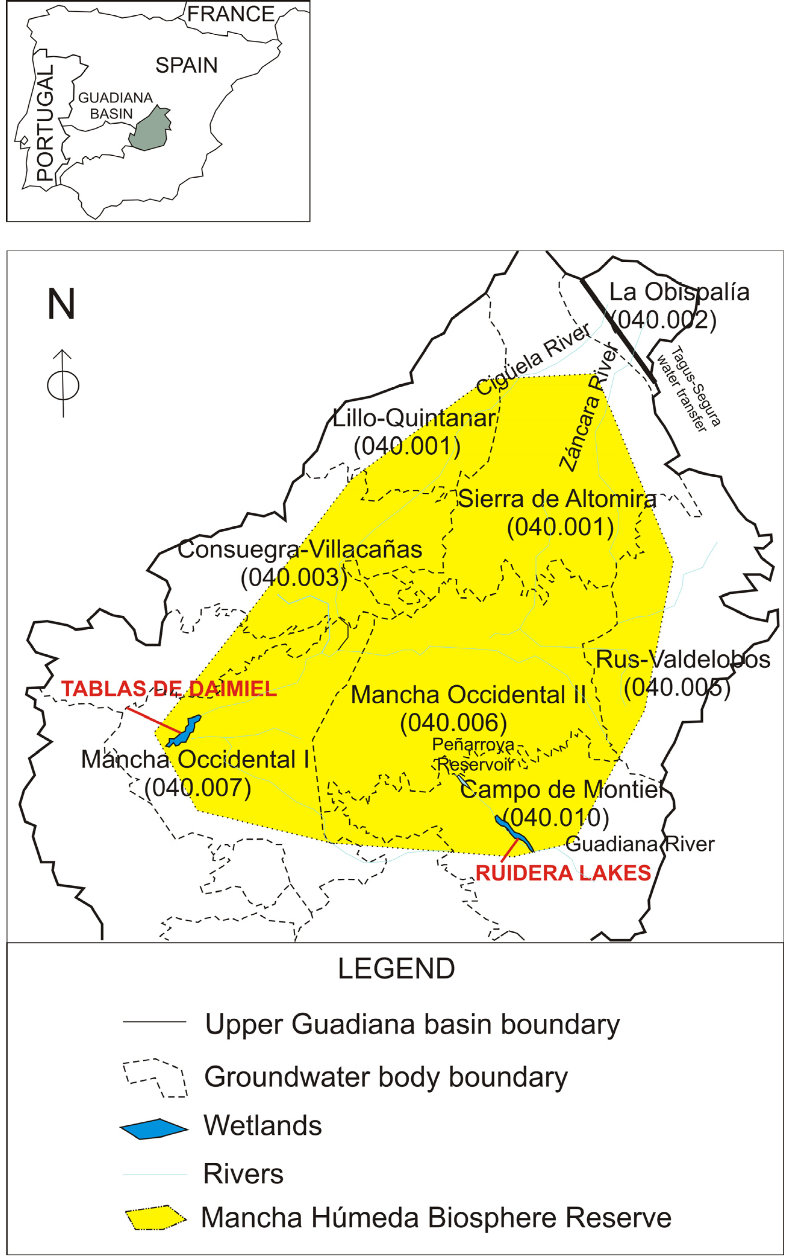
The Mancha Húmeda includes 113 wetlands distributed in different zones [
14] characterized by significant groundwater interaction. The flooded surface area covers approximately 250 km
2 although it is now estimated that only 20% of the original area remains, with few of the wetlands functioning naturally [
15]. It was designated by the UNESCO in 1980 as the ‘Mancha Húmeda’ Biosphere Reserve. The Mancha Húmeda includes seven groundwater bodies (GWBs) (
Figure 2) and water body 040.007 (Mancha Occidental I), is the main collector of the system,
i.e., of both the subterranean flow from the groundwater bodies to the north (Sierra de Altomira, Obispalía, Lillo-Quintanar, Consuegra-Villacañas and Rus-Valdelobos) and to the south (Campo de Montiel) (
Table 5). The two most important wetlands in this complex are the Tablas de Daimiel and the Ruidera Lakes.
Figure 2.
Groundwater bodies (GWB) and wetlands studied in the Upper Guadiana Basin.
Figure 2.
Groundwater bodies (GWB) and wetlands studied in the Upper Guadiana Basin.
Table 5.
Correspondence between aquifers and groundwater bodies in the Guadiana Basin.
Table 5.
Correspondence between aquifers and groundwater bodies in the Guadiana Basin.
| Aquifer | GWB Code | GWB Name |
|---|
| Sierra de Altomira | 041.001 | Sierra de Altomira |
| La Obispalía | 041.002 | La Obispalía |
| Lillo-Quintanar | 041.003 | Lillo-Quintanar |
| Consuegra-Villacañas | 041.004 | Consuegra-Villacañas |
| Western Mancha Aquifer (WMA) | 041.005 | Rus-Valdelobos |
| 041.006 | Mancha Occidental II |
| 041.007 | Mancha Occidental I |
| Campo de Montiel | 041.010 | Campo de Montiel |
The Tablas de Daimiel (TD) form an area with numerous wetlands of endorheic origin and non-permanently flooded areas originating in the overflow of the Guadiana, Gigüela, Záncara and Riansares rivers (
Figure 2). Under natural conditions the wetland receives brackish water from the river Gigüela, fresher water from the Guadiana, and also medium salinity from the aquifer WMA (Mancha Occidental I,
Figure 2) due to effluents conditions. In dry years the TD receive water transferred from the Tajo-Segura aqueduct channelled through the river Gigüela (
Figure 2), and pumped water from the underlying aquifer, as a maintenance strategy measure [
16] (
Table 6).
Table 6.
Volumes transferred from the Tagus-Segura aqueduct to the Tablas de Daimiel (TD) through the course of the Gigüela River (data provided from [
17].
Table 6.
Volumes transferred from the Tagus-Segura aqueduct to the Tablas de Daimiel (TD) through the course of the Gigüela River (data provided from [17].
| Hydrological Year | Water diverted to TD (million of m3) | Hydrological Year | Water diverted to TD (million of m3) |
|---|
| 1988–1989 | 12.10 | 2001–2002 | 20.00 |
| 1989–1990 | 13.30 | 2002–2003 | 25.00 |
| 1990–1991 | 15.80 | 2003–2004 | 9.40 |
| 1991–1992 | 17.80 | 2004–2005 | 0.00 |
| 1992–1993 | 6.50 | 2005–2006 | 0.00 |
| 1993–1994 | 0.00 | 2006–2007 | 10.00 |
| 1994–1995 | 15.00 | 2007–2008 | 0.00 |
| 1995–1996 | 0.00 | 2008–2009 | 20.00 |
| 1996–1997 | 30.00 | 2009–2010 | 1.50 |
| 1997–1998 | 0.00 | 2010–2011 | 0.00 |
| 1998–1999 | 0.00 | 2011–2012 | 0.00 |
| 1999–2000 | 26.00 | 2012–2013 | 0.00 |
| 2000–2001 | 20.00 | | |
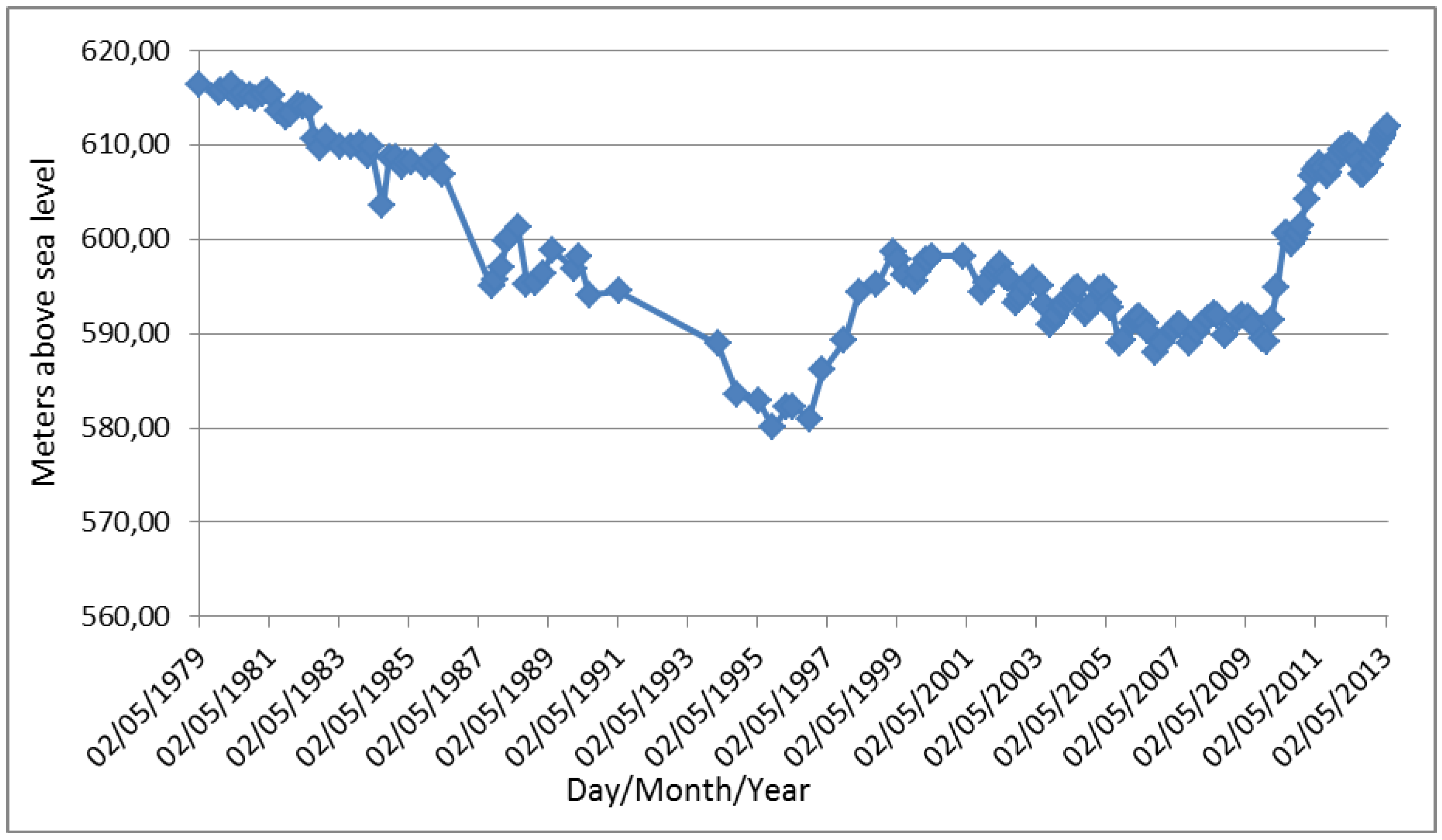
In their natural regime, the TD are flooded as a result of the flat relief of this area (610–630 m a.s.l.) [
18] and the high water table which surfaces in wet periods causing the natural discharge of the aquifer. The phreatic surface is currently found well below the topographic surface due to the influenced regime of the GWB (
Figure 3), so that the process is inverted and this zone functions as an infiltration area, and therefore, as an aquifer recharge area. Nevertheless, according to the latest data in April 2013, the water table is about 3 m deep in the so called Ojos del Guadiana, the spring of the Guadiana River inside the Mancha Occidental I GWB (
Figure 3).
In 1966 the Tablas de Daimiel were designated a national hunting reserve (Reserva Nacional de Caza); in 1979 they were designated as an ornithological special protection area (Zona de Especial Protección para las Aves ZEPA); The Tablas de Daimiel were designated a National Park (Parque Nacional de Las Tablas de Daimiel), in 1973, and reclassified in 1980. In 1982 it was included in the RAMSAR Convention and classified as a wetland of international importance [
14] (
Table 7).
What was formerly known as the Acuífero de la Mancha Occidental (Western Mancha Aquifer-WMA), which included the current GWBs Rus-Valdelobos, and Mancha Occidental I and II (
Table 5), has been intensively exploited since the 1970s. In the last 40 years the intensive use of groundwater in the 5000 km
2 area of the WMA has represented the extraction of around 20,000 million of m
3 (Mm
3) of water, with 3,000 Mm
3 coming from groundwater storage, causing a 25 m drawdown of the water level [
19,
20]. As a consequence, the Guadiana Water Authority (CHG in its Spanish acronym), agreed in 1987 to declare the WMA provisionally overexploited. Later, in 1994, it was declared definitively overexploited.
Figure 3.
Evolution of piezometric level close to the Tablas de Daimiel [data provided by Miguel Mejías-Geological Survey of Spain (IGME)].
Figure 3.
Evolution of piezometric level close to the Tablas de Daimiel [data provided by Miguel Mejías-Geological Survey of Spain (IGME)].
Table 7.
Legally protected categories applying to the Tablas de Daimiel wetland.
Table 7.
Legally protected categories applying to the Tablas de Daimiel wetland.
| Year | Protected category |
|---|
| 1966 | National Hunting Reserve |
| 1973 | National Park |
| 1979 | ZEPA |
| 1980 | Reclassified |
| 1980 | TD included in the Mancha Húmeda Biosphere Reserve |
| 1982 | Included in Ramsar List |
TD has a strong symbolic value for a number of reasons. It represented a landmark in a largely arid and poor region, which thanks to natural springs and so called tablas, provided sustenance for the local population from fisheries, crabbing and associated land uses like small orchards. It is also a reference in Spanish conservation history as a symbol for reversing existing policies. Some watercourses were channeled and modified to increase agricultural land at the beginning of the same year that the Park was designated (1973).
The TD wetlands system is sustained by the WMA aquifer (
Figure 2 and
Table 5). This is an unconfined aquifer composed of limestone in its upper part. Deeper down there are siltstones, sands and conglomerates, all from the Miocene age. The basement of the basin is composed of Jurassic and Cretaceous carbonate materials in the east and of impervious Palaeozoic and Triassic materials in the west. The hydrogeological cross section (
Figure 4) shows that the lowered water table has left the TD suspended over the saturated zone of the aquifer, which at present is still the case [
19].
Figure 4.
Evolution of the water table in the Tablas de Daimiel area (adapted from [
21]). The position of the hydrogeological cross section is shown in
Figure 2.
Figure 4.
Evolution of the water table in the Tablas de Daimiel area (adapted from [
21]). The position of the hydrogeological cross section is shown in
Figure 2.
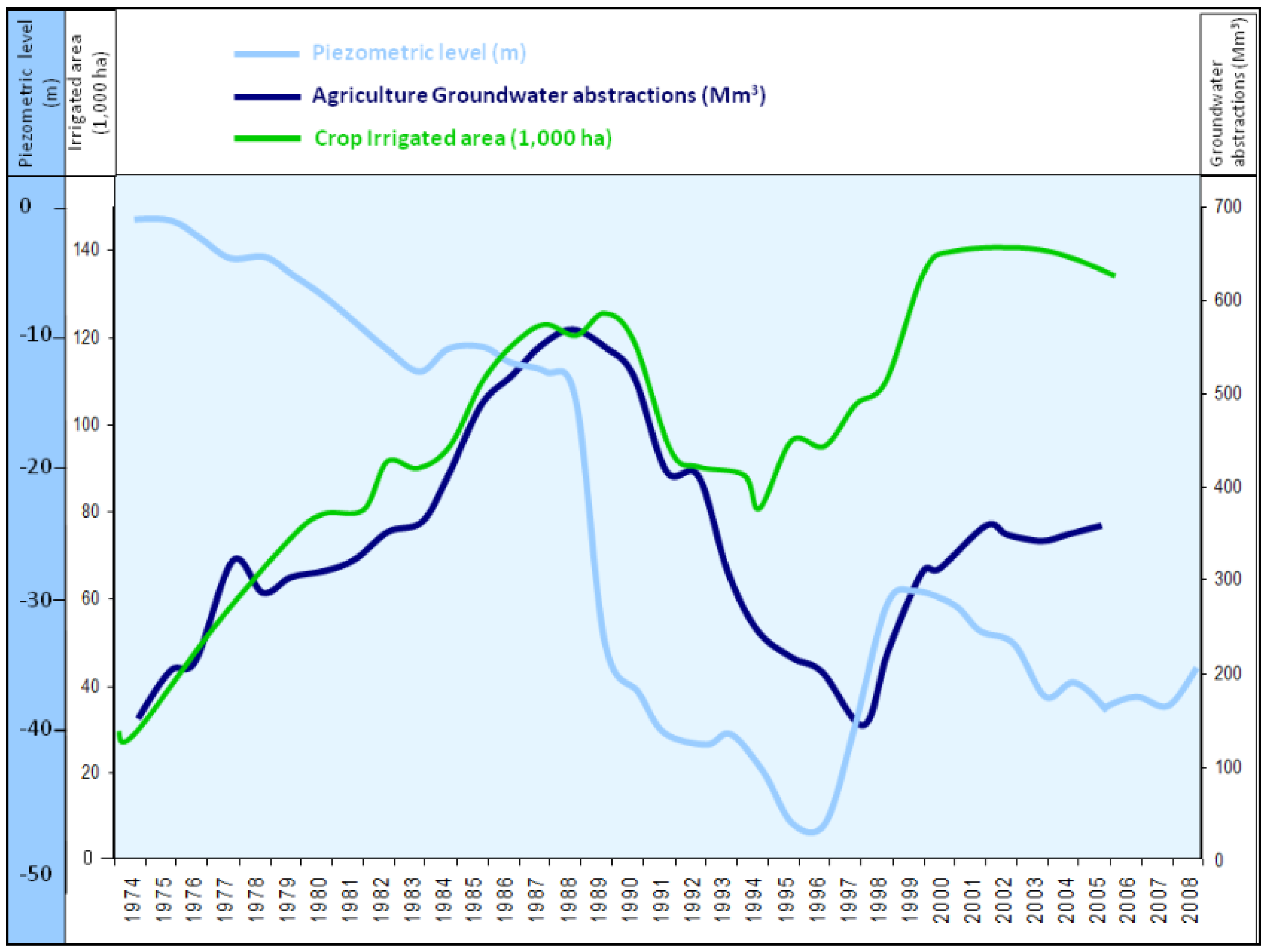
Over a relatively short period of time the area went through a profound socio-ecological transformation with large environmental externalities, since groundwater stopped overflowing from the WMA into TD. From 1974 to 1984 groundwater use grew from less than 200 Mm
3/year to 500 Mm
3/year, when the estimated renewable resources were from 260 to 300 Mm
3/year. The record of extractions was reached in 1988 with the pumping of 570 Mm
3 [
22]. The area under irrigation over the same period increased over four times, from 30,000 ha to 130,000 ha (
Figure 5).
There have been a number of public policy measures that have been implemented in the area to address the conflict between agriculture and wetland protection. The most recent public policy initiative is the Special Plan for the Upper Guadiana (SPUG) approved in 2008. It is considered the most important part of the Action Plan for the future Guadiana Hydrological Plan, conceived to restore the three groundwater bodies that cover the WMA to comply with the WFD [
23,
24].
Since January 2010 (
Table 6) no water has been transferred to the TD and no other measures have been taken, as rainfall has been heavy. The TD have made a spectacular recovery and have reached their maximum recorded extent. Similarly, the aquifer levels have risen drastically (
Figure 3) at some points [
20], although without reaching the original levels of the early 1970s.
Figure 5.
Evolution of the piezometric level, agricultural groundwater abstraction and irrigated area between 1974 and 2008 [
23].
Figure 5.
Evolution of the piezometric level, agricultural groundwater abstraction and irrigated area between 1974 and 2008 [
23].
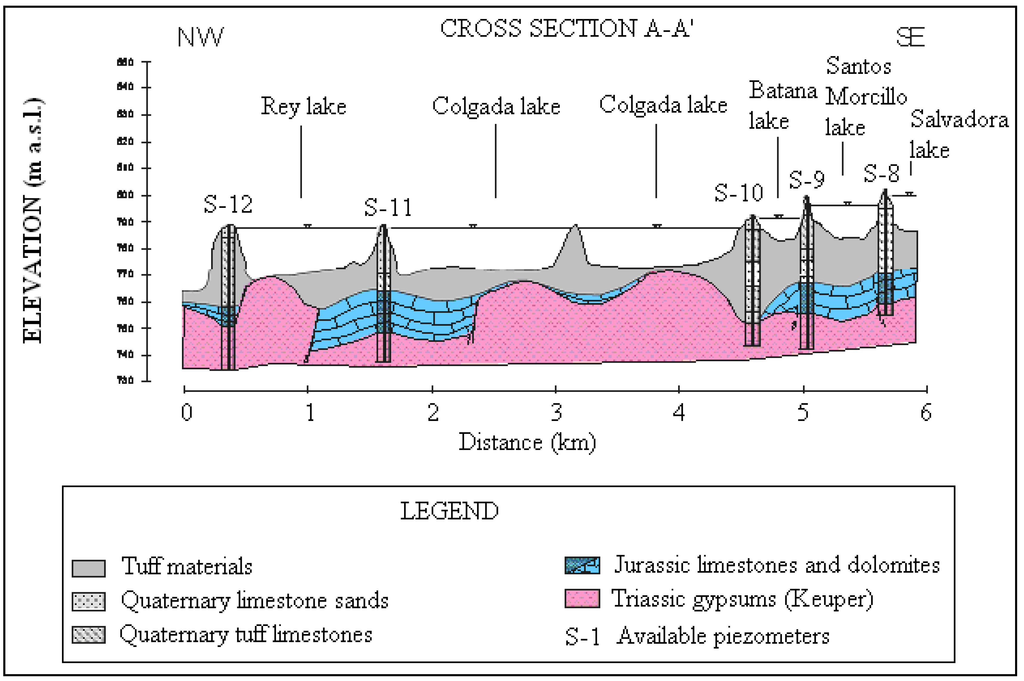
3.2. Ruidera Lakes
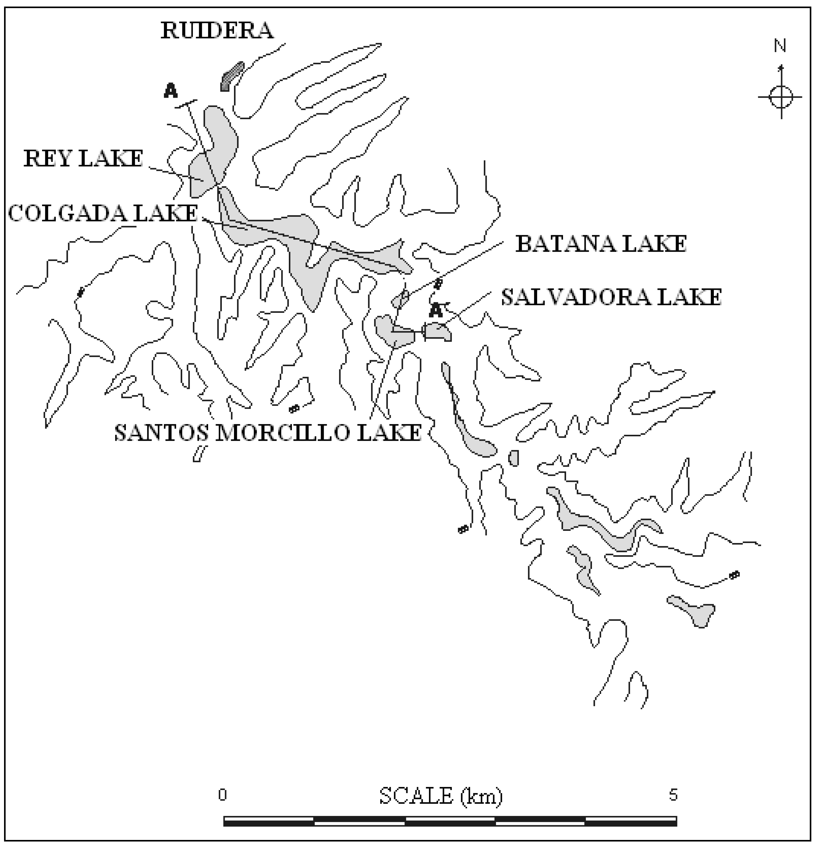
These unique wetlands are of significant value in the interior of the arid Castilla-La Mancha plateau. This area is renowned for its magnificent fauna and freshwater flora, rich biodiversity, beautiful landscape, the colour of its clear waters and the traditional folklore related to the subterranean rivers, mentioned in the adventures of Don Quixote. The lake water is basically groundwater, which resurges in springs and pools to form a chain of 15 lakes (
Figure 6 and
Table 8). These appear as a 35-kilometer-long series of steps with a difference in height of 120 m between the highest and lowest [
25]. The lakes are connected by torrents, waterfalls, springs or channels which are dammed by a series of natural dikes resulting from carbonate precipitation (travertine) on small original barriers [
26]. The series of lakes covers a surface area of 300 ha with a dammed volume of around 23 Mm
3. The Ruidera Lakes (RL) are located on a carbonated upland on the northern edge of the central peninsular plateau (
Figure 2). The local geology is composed of a Palaeozoic metamorphic basement (quartzite and slate) with a heterogeneous deposit of Mesozoic sediments (Triassic and Jurassic). The Triassic-Jurassic complex varies considerably in depth and is affected by fractures, folds and diapiric processes. The end result is a compartmentalization of the aquifer materials, affecting its hydrological function. The upper Triassic layer is composed of marls and gypsum-rich clays, forming an impervious bedrock under the Jurassic carbonate materials of the Campo de Montiel aquifer. It is interesting to note the Quaternary travertine deposits, various metres thick, on which the series of lakes are located (
Figure 6). Some of these are evidently older, and are several metres above the current level of the lakes.
Figure 6.
Ruidera Lakes showing the cross section also represented in
Figure 7 (adapted from [
25] and [
27]).
Figure 6.
Ruidera Lakes showing the cross section also represented in
Figure 7 (adapted from [
25] and [
27]).
Table 8.
Morphometric parameters of Ruidera Lakes (developed and adapted from [
25] completed with results obtained through Google Earth).
Table 8.
Morphometric parameters of Ruidera Lakes (developed and adapted from [25] completed with results obtained through Google Earth).
| Lake | Length (m) | Width (m) | Depth (m) |
|---|
| Blanca (980 m asl) | 850 | 400 | Minimal |
| Concejo | 1990 | 300–400 | 14 |
| Tomilla | 500 | 300–400 | 14 |
| Tinaja | 600 | 200 | 17 |
| S. Pedro | 1600 | 400 | 21 |
| Redondilla | 190 | 190 | 10 |
| Lengua | 1400 | 250 | 14 |
| Salvadora | 450 | 400 | 12 |
| Santos Morcillo | 800 | 400 | 14 |
| Batana | 400 | 400 | 8 |
| Colgada | 2 400 | 400 | 18 |
| Del Rey | 950 | 400 | 20 |
| Cueva Morenilla | 600 | 180 | 7,85 |
| Coladilla | 400 | 300 | 7,55 |
| Cenagosa (720 msnm) | 400 | 250 | Minimal |
The RL are located over the 2500 km
2 040.010 Campo de Montiel groundwater body (
Figure 2). Due to problems in the mid 1980s attributed to the pumping of irrigation wells, the relevant authorities declared the Campo de Montiel aquifer provisionally overexploited in 1988 and definitively overexploited in 1989, although the renewable resources are officially 125 Mm
3/year and the abstractions only 35 Mm
3/year. The rest is water transferred to the Mancha Occidental II GWB (between 20 Mm
3 and 50 Mm
3) and surface runoff water that drains to the RL [
19].
The lakes have been protected to some extent for many years: in 1933 they were declared a Natural Site of National Interest. Since July 1979 the area has been a Natural Park and more recently, in 2011, was declared a Ramsar area of international importance.
Figure 7.
Hydrogeological cross section of Ruidera Lakes (adapted from [
25] and [
27]).
Figure 7.
Hydrogeological cross section of Ruidera Lakes (adapted from [
25] and [
27]).
The water in the lakes is basically groundwater, which surfaces in springs and pools in the series of lakes described above. Montero [
28] shows that the water level in the RL depends to a considerable extent on the geometry of the lake basin, on the geological structure and on the level of abstractions from the aquifer and its function. This means that some lakes are closely linked to the Jurassic aquifer, others are fed by surface water supplied by the channels connecting them to the lake immediately above, and a third group of lakes (
i.e., La Colgada and Del Rey) are supplied from lateral surface water and from the lakes upstream.
Existing problems include contamination by nitrates used in agriculture, wastewater discharge (now almost eliminated as a result of the recently inaugurated Ruidera wastewater treatment plant), and the adverse effects of tourism within the whole perimeter of the RL, which may affect water quality. Other threats include access routes, periodic burning of stubble, felling timber for charcoal, or over-grazing.
The studies by Montero [
25] and Eugercios [
29] have highlighted how sensitive the lake water levels are to aquifer pumping. This aquifer has very little regulatory power due to its high permeability resulting from the karstification of the aquifer (which means it empties quickly) and also to the shallow saturated layer.
In recent years, successive episodes of intense rainfall have filled the lakes: in 1996–1997, from December 2009 until the summer of 2012, and again at present (spring 2013).


