1. Introduction
At the beginning of this century, the Global Water Partnership (GWP) [
1] put forward the concept of Integrated Water Resources Management (IWRM) as part of the sustainable development defined by the World Commission on Environment and Development. The GWP defined the IWRM as “a process that promotes the coordinated development and management of water, land, and related resources, in order to maximize the resultant economic and social welfare in an equitable manner without compromising the sustainability of vital ecosystems” [
1,
2,
3]. IWRM considers the complex interactions among various physical, environmental, socio-economic, political, and legal components. It is essential for ensuring the sustainability of water resources and, consequently, the sustainability of national development.
Despite its widespread adoption, IWRM has faced criticism for being too broad and lacking clear implementation strategies. For instance, Falkenmark [
4] emphasized the importance of integrating environmental considerations and ecosystem dynamics into water management strategies, while Biswas [
5] critiqued the broadness of the IWRM concept, arguing that its implementation often lacks specific strategies tailored to local contexts. Similarly, Claassen [
6] highlighted the need for adaptive approaches in IWRM to address dynamic socio-economic and environmental conditions. In response to these critiques, the recent literature emphasizes the importance of adopting a more adaptive approach to overcome the limitations of traditional IWRM frameworks [
2]. Adaptive IWRM recognizes that rigid, one-size-fits-all frameworks may not be suitable for diverse water management contexts and instead promotes locally tailored strategies that evolve with changing conditions.
In regions characterized by semi-arid and arid climates, water management faces many challenges, mainly due to the inherent scarcity of water resources. The aridity of the landscape exacerbates pressure on already limited sources of fresh water, intensifying competition between different sectors for access to this precious resource. In these regions, surface water resources are typically scarce, making groundwater the primary water source [
7,
8]. The impacts of climate change on precipitation variability further exacerbate pressure on groundwater resources, particularly in these areas [
9].
Climate change further compounds the pressure on groundwater resources by increasing precipitation variability, particularly in arid and semi-arid areas [
9,
10]. These changes highlight the urgent need for robust modeling tools to assess water availability, predict future trends, and inform sustainable resource allocation strategies.
Given these challenges, there is a growing need for sophisticated modeling tools to accurately assess water availability, predict future trends, inform about sustainable resource allocation strategies and manage groundwater sustainably in these regions. IWRM models offer valuable tools for understanding the complex interactions between surface water and groundwater systems, as well as the socio-economic factors influencing water use. By incorporating hydrological, environmental, and socio-economic data, IWRM models can assist policymakers and stakeholders in making informed decisions concerning water allocation, conservation measures, and risk mitigation strategies. Implementing these models can enhance the resilience of water management practices in semi-arid and arid climates, ensuring the long-term sustainability of groundwater resources for both current and future generations [
11,
12,
13,
14,
15,
16].
Various models have been developed to address these challenges. For example, MODFLOW, developed by the U.S. Geological Survey (USGS), is a widely used numerical model for simulating groundwater flow [
17,
18], while SWAT (Soil and Water Assessment Tool) [
19] emphasizes watershed-scale hydrology and land-use impacts. However, for this study, the Water Evaluation And Planning System (WEAP) was chosen due to its comprehensive capabilities in integrating hydrological, environmental, and socio-economic data, as well as its ability to evaluate a wide range of water development and management options while accounting for multiple and competing uses of water systems [
20]. Moreover, the region already features a decision support system (DSS) for another key water resource, Zeuss Koutine, making the use of WEAP a complementary approach that reinforces the previous study and provides a more integrated understanding of regional water dynamics.
The WEAP model has been applied in numerous studies across the world for many years. A. Al-Omari et al. [
21] developed a water management support system for the Amman Zarqa Basin in Jordan using the WEAP model. The model was calibrated, validated, and run with four scenarios. Hollermann et al. [
22] used WEAP to analyze Benin’s future water situation under different scenarios of socio-economic development and climate change. Mounir et al. [
23] developed a WEAP model to assess future water demands in the Niger River (in the Niger Republic). Abera Abdi and Ayenew [
24] studied the subbasin hydrologic behaviors of the Ketar subbasin in the main Ethiopian Rift Valley basin. Dimova et al. [
25] applied two modern tools, the System of Economic and Environmental Accounts for Water (SEEAW) and the WEAP, to assess holistically the available water resources and the socio-economic water needs within the Vit River catchment in Bulgaria. Vonk et al. [
26] studied an adapting multi-reservoir (dam) operation to reduce the potential impacts of climate change and regional socio-economic developments for the Xinanjiang-Fuchunjiang reservoir cascade, located in Hangzhou Region (China). Li et al. [
27] analyzed the future water situation in the The Binhai New Area in China, by setting different scenarios of social development and urbanization, and used WEAP to evaluate the sustainability of limited water resources management strategies. Yaqob et al. [
28] applied the WEAP model in evaluating and analyzing the existing balance and the role of treated wastewater. The model anticipated future scenarios for the management of water resources in the Nablus and Tulkarm watersheds in Palestine. Shahraki et al. [
29] studied water resources management under environmental scenarios using the WEAP model in the Hirmand catchment in Iran. They applied dust stabilization and animal–plant sustainable ecosystem scenarios and their economic assessment. Al-Mukhtar and Mutar [
30] used WEAP to identify the optimal water allocation among the domestic, agricultural, and industrial sectors of Baghdad city under present and potential future scenarios. Hadded et al. [
31] developed a decision support system (DSS) for the groundwater management of the Zeuss Koutine aquifer in southeastern Tunisia using the WEAP-MODFLOW framework. The DSS was used to simulate the behavior of the studied aquifer and the hydraulic system of the governorate of Médenine under different water management scenarios. Hadded et al. [
32] described the impact of different climate change scenarios on the Zeuss Koutine aquifer hydraulic heads and storage capacity. Lima-Quispe [
33] developed an integrated modeling framework in WEAP to estimate the water balance of Lake Titicaca (South America), accurately simulating water levels by considering upstream inflows, precipitation, evaporation, and downstream outflows, showing that lake fluctuations are primarily driven by precipitation and evaporation rather than snow, ice, or irrigation withdrawals.
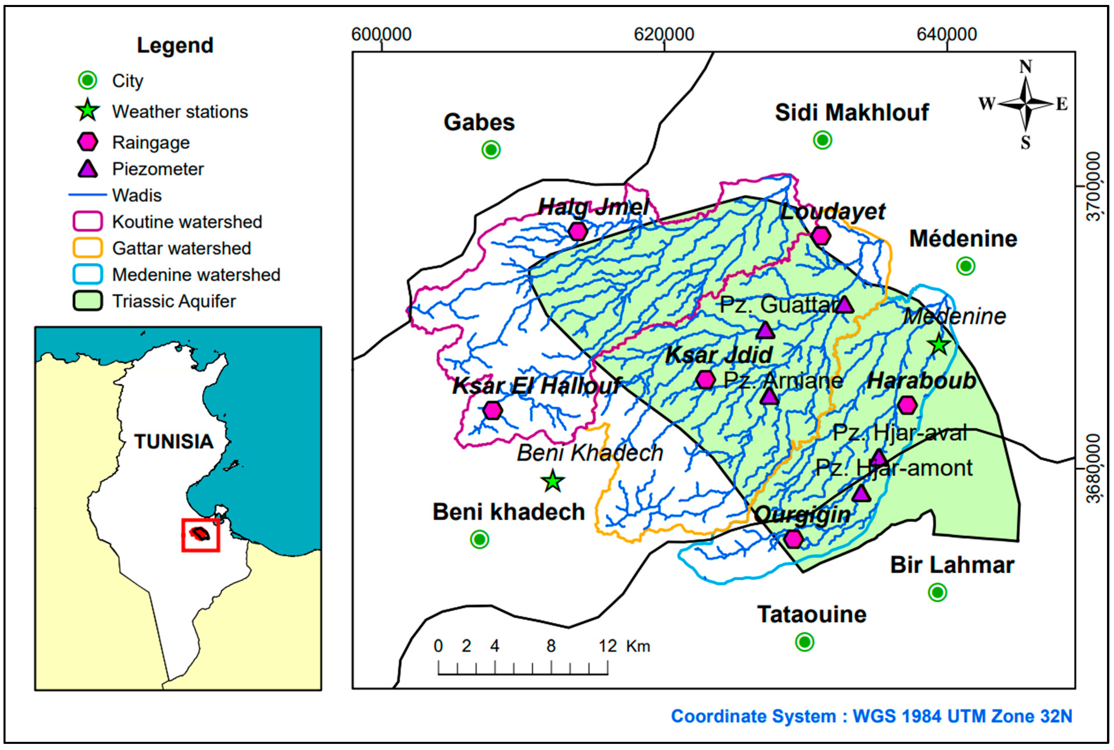
Recent decades, population growth, rapid urbanization, improved water supply, and the convergence of coastal zones to mainly tourist destinations have made the governorate of Médenine in southern Tunisia face great water management challenges, especially with the scarcity of water resources in such arid climate conditions. The improvement in water supply was accompanied by a gradual and unlimited increase in demand up to the present. The study site is the extent of the Triassic sandstone aquifer of Sahel El Ababsa, located in the west of Médenine city, which is part of the Tunisia southeastern region. The area of the aquifer is shared by three main watersheds: Koutine, Gattar, and Médenine (also called Hjar) watersheds. The study area belongs entirely to the coastal plain of Jeffara of Médenine. It is characterized by an arid climate. Given the scarcity of precipitation, groundwater resources represent the main water resource of the cities of the governorate of Médenine. The hydro-system of Médenine relies mainly on the Zeus-Koutine aquifer and secondly on the Triassic aquifer as groundwater resources. In order to solve the water scarcity in the study area, it is important to improve water use efficiency through optimizing water resource management.
Since 1990, the Tunisian government has launched a strategy for water and soil conservation. The main used structures in the study area are the traditional runoff water harvesting techniques (WHT) called
Jessour and
Tabias. The
Jessour consists of a number of Jessr, which is a hydraulic unit installed at the talwegs of valleys, mountainous, and gentle slope areas. The Jessr is used not only to allow the retention of runoff water and sediments, but also to create rich agricultural areas, conserve the vegetation cover, and recharge the aquifer [
34,
35].
Tabias are similar to the
jessour; they are essentially situated on gentle slopes, in the piedmont surfaces, and in the middle of the watershed [
36,
37].
Recharging aquifers by recharge wells is a technique used mainly for aquifers with calcareous structures presenting low permeability. They show a notable efficiency in recharge even with the naked eye during the observation visits. A
recharge well consists of an inner long tube leading to the watertable or permeable layer and an outer tube at the surface fixing the gravel filter [
37,
38,
39,
40].
This paper describes the use of the WEAP software tool to develop a DSS to model the hydro-system of the Médenine governorate in southeast Tunisia and to simulate the climate change (CC) impact on the Triassic aquifer of Sahel El Ababsa, in order to help manage the region’s limited water resources and assess the impact of projected climate and planning scenarios.
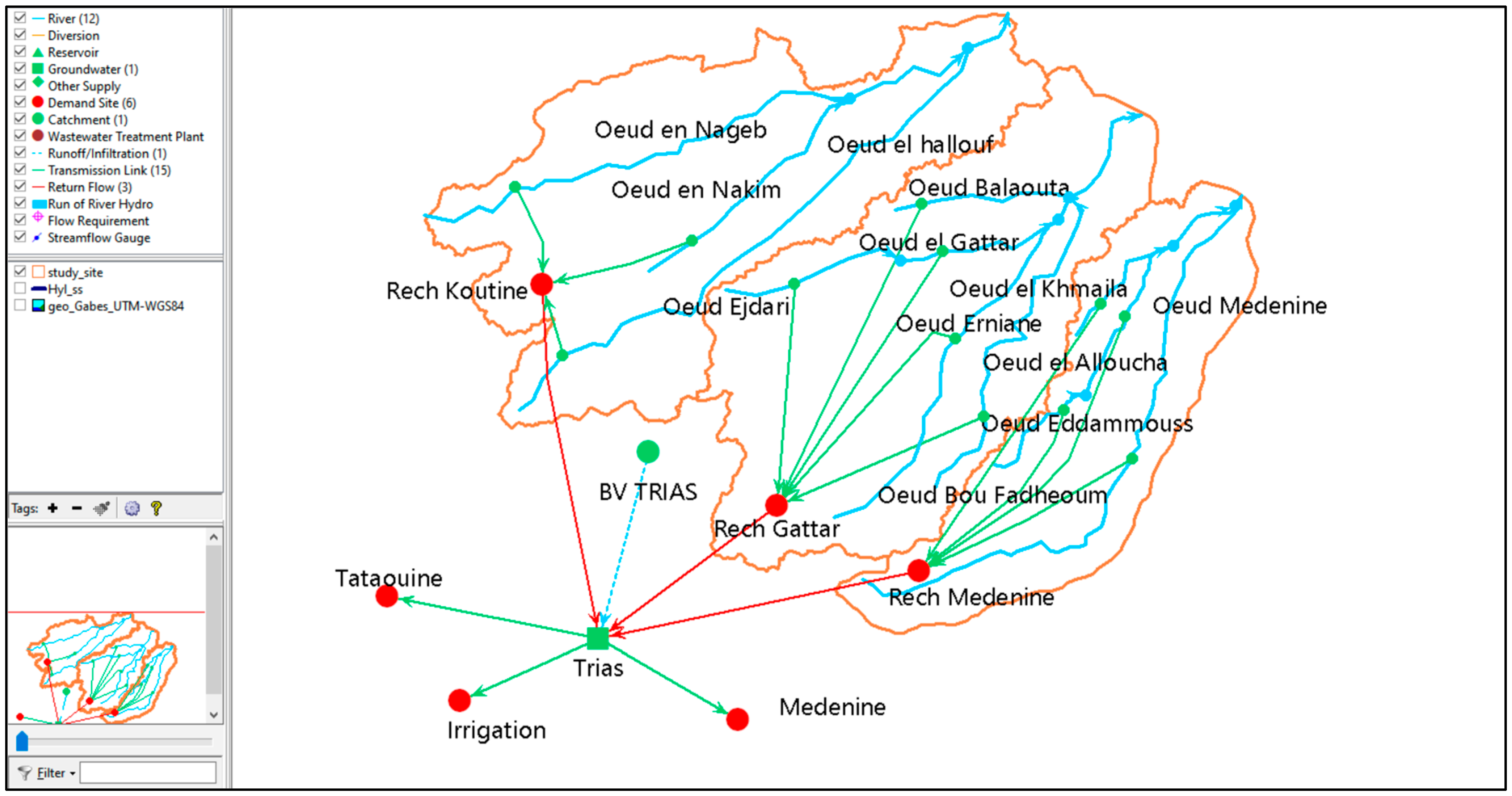
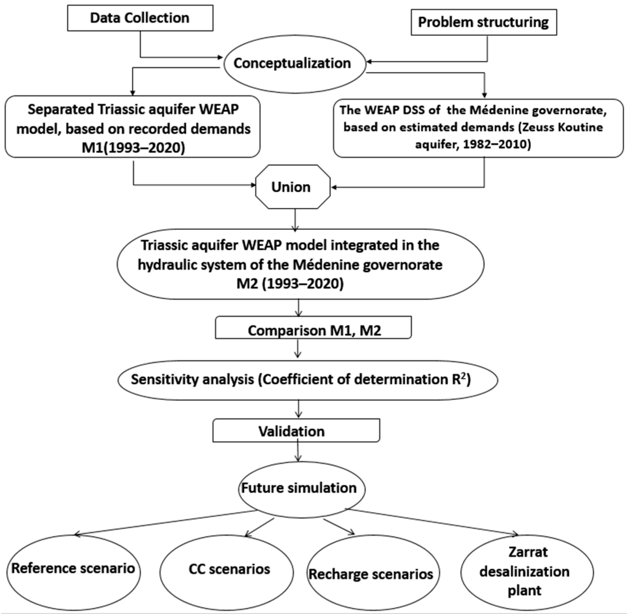
To achieve the present DSS, first, a database of climatic, geologic, hydro-geologic, hydraulic, and management information was created. In the second step, the WEAP software [
20,
41] was used to develop a conceptual model of the bio-hydro system of the Triassic aquifer using only the observed data for the different supplies and demands, then presenting the studied aquifer separated from the other components of the hydro-system in the region. In the last step, a union was made between the Triassic aquifer model and the developed WEAP DSS established already for the hydro-system of the Médenine governorate by the main author and describing all the water resources contributing to the water supply for the whole governorate [
31,
32]. The simulation period for the WEAP project is from 1993 to 2020 with a monthly time step. The forecast period is from 2020 to 2050. The reference scenario postulates maintaining the same climatic conditions, socio-economic activities, and WRM conditions as those of 2020.
Given its strategic importance for the region, this work aims to understand the behavior of the Triassic sandstone aquifer of Sahel El Ababsa and its interaction with the climate conditions and human activities and management during the forecast period from 2020 to 2050. The present DSS provides a forecast of future water demands based on the estimates of demographic development associated with the future evolution of specific daily consumption per person in the main cities of the study area, whether domestic or tourist consumption, such as in the major tourist centers of Djerba and Zarzis. It gives an idea of the evolution of irrigated areas under different rates of change, thus forming development scenarios for decision-makers.
The DSS was used to simulate the climatic scenarios in the forecast period. The future climatic data are given from the National Institute of Meteorology reports (INM) [
42]. They were generated using a set of different RCMs (Regional Circulation Models). Two different RCPs (Representative Concentration Pathways) were used to forecast the precipitation: the RCP4.5 and the RCP8.5. The DSS emphasizes the importance of WHT to manage the aquifer recharge. The DSS is able to forecast the behavior of the studied aquifer and the response of various other conventional resources in the governorate of Médenine in the face of scenarios outlined within the strategy for mobilizing non-conventional water resources, through the establishment of desalination stations.
3. Results
3.1. Calibration and Validation
WEAP provides an extensive list of results concerning demand components, water supply and resources, catchment, water quality, financial, and other results. The main result that concerns the present study is the storage of the Triassic aquifer, which reflects the impact of the different management and development strategies of the region on the groundwater resources.
These results are given first, according to the reference scenario (SC0), which assumes continuing the same water resources management conditions in the future as those of the year 2020. The same resources from this year are considered; the projected resources are not affected by this scenario and the demands follow a calculated evolution. The recharge is assumed to have an increase in the indirect recharge rates from the year 1995 until the year 2010 to show the effect of the WHT and then a reduction in these rates until the end of the simulation period to show the real effect of the poor maintenance of these structures.
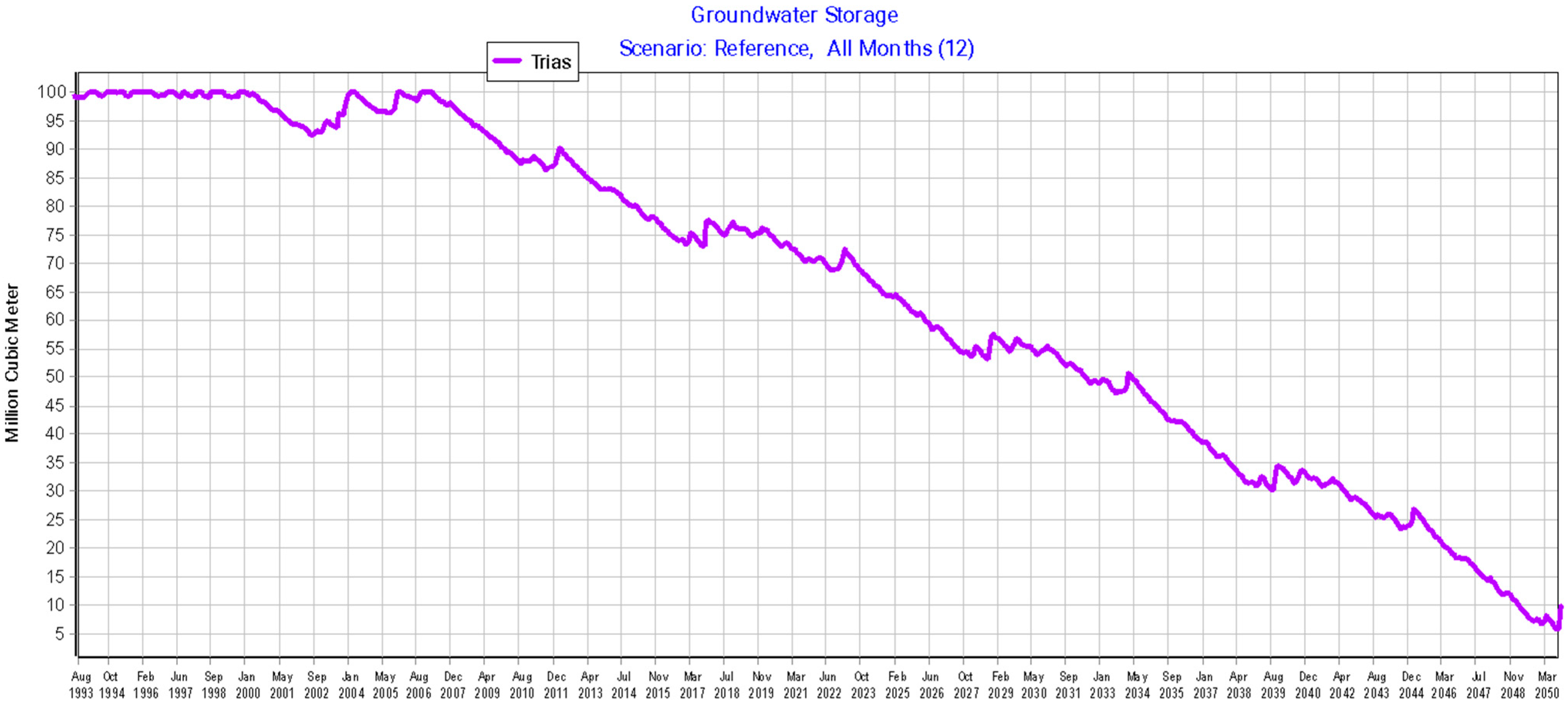
The initial storage of the Triassic sandstone aquifer was estimated by the CRDA at 100 Mm3. In the initial model of the Triassic aquifer (M1), the simulation reveals a continuous decline in groundwater storage beginning in 2007. By 2050, the aquifer’s storage is projected to decrease to 7.36 Mm3, representing a dramatic reduction of approximately 92% compared to its initial capacity.
This significant decline highlights the critical state of water resources in the Médenine region.
Figure 12 illustrates the evolution of the Triassic aquifer’s storage throughout the simulation period using the M1 WEAP model.
The Triassic aquifer is modeled in a second step, integrated within its environmental context, based on the estimation of water supply and demand across all water resources utilized in the hydraulic system of the Médenine governorate (M2). The integrated model builds upon the Zeuss Koutine aquifer WEAP model, previously calibrated and validated by the lead author [
31,
32,
64].
Starting with the same estimated initial storage capacity and initial groundwater storage, the aquifer is projected to experience a continuous decline, reaching 23.71 Mm
3 by 2050. This represents a reduction of approximately 76.29%, as illustrated in
Figure 13.
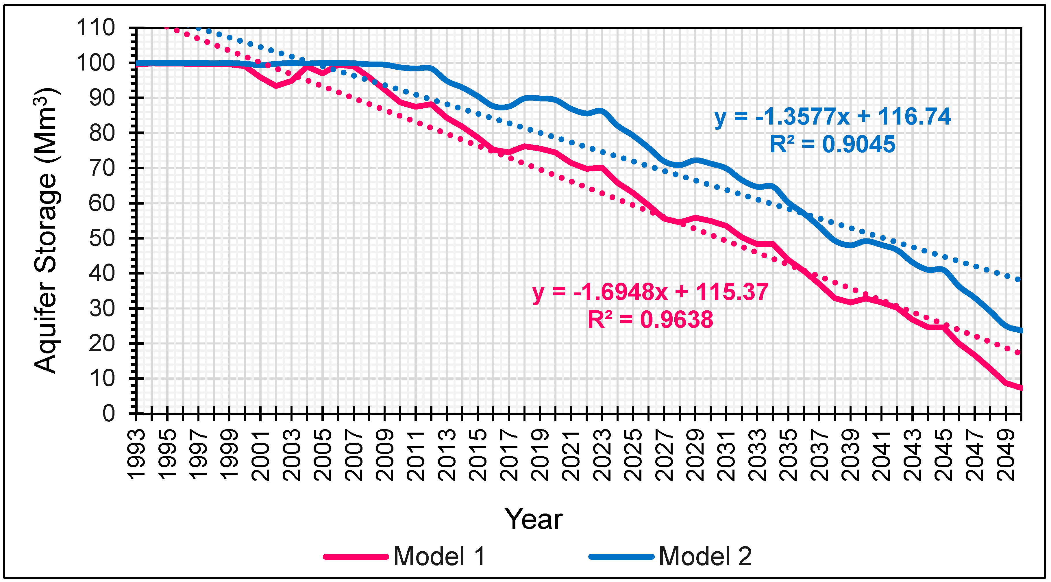
Figure 14 illustrates the linear regression curve of the storage variable of the Triassic sandstone aquifer, calculated in the two aforementioned models. This regression highlights the relationship and discrepancies between the two models, offering insights into how the aquifer’s storage dynamics differ under each modeling approach.
The coefficient of determination R
2 lies between 0 and 1. In this case, the calculated coefficient of determination is equal to 0.98.
Figure 15 illustrates the trends of the groundwater storage curves for the Triassic aquifer, as simulated by the two referenced models. Both curves exhibit a similar pattern, and their relationship is further analyzed through a linear regression. The linear regression highlights the trend of continuous depletion in groundwater storage over time, providing a simplified representation of the relationship between storage decline and the simulation period. The high adjusted coefficient of determination R
2, exceeding 0.9, indicates a strong correlation between the two models. This suggests that despite some differences in approach, the models provide consistent projections of groundwater storage trends, reinforcing the reliability of the estimations and calculations adopted in model M2.
The hydraulic system model simulating the Zeuss Koutine aquifer [
31,
32,
64] has been rigorously calibrated, validated, and tested post-validation. It provides a precise estimation of water demand. The calibration process was carried out not only based on the aquifer’s piezometric levels but also by comparing the volumes distributed to the main demand centers with those calculated by the model.
The calibration was carefully performed by adjusting several parameters, including population growth, its distribution across demand sites, and the specific water consumption per person. This initial calibration work was conducted on the hydraulic system model of Médenine [
31,
32,
64], which at that time incorporated all the water resources of the governorate. The evolution of the key input parameters has since been tested and validated.
In the M2 model, these parameters were integrated while updating the necessary data, as explained in the methodology section. The comparison between the model based on observed data (M1) and the one based on estimations (M2) resulted in a determination coefficient of R2 = 0.9, confirming the consistency of the obtained results.
However, due to the water blending strategy adopted by SONEDE (where water from multiple sources is mixed in reservoirs before redistribution) it is challenging to calibrate the model using distributed volumes. Thus, the only directly comparable parameter is the volume of water pumped from the Triassic aquifer before reaching the reservoirs. This justifies our validation approach, which relies on the flow rates in the transmission links between the aquifer and the Médenine demand sites.
Figure 16 provides a comparison between the recorded pumped volumes from the Triassic aquifer to the reservoirs and the calculated flow rate, which represents the water demand of the Médenine demand site from the Triassic aquifer. This figure shows an R
2 = 0.86, which indicates a strong correlation between the observed and simulated volumes, suggesting a good model fit.
In summary, the results are highly satisfactory across the entire simulation period. Both models exhibit a similar trend in the storage parameter curve, with final results showing close alignment. The results confirm the robustness of the hydraulic system model in estimating water demand and groundwater storage evolution over time. Consequently, the final WEAP model of the Triassic aquifer (M2), integrated into the broader hydro-system of Médenine, is validated and will be used in subsequent analyses. The updated model, referred to as M2, will subsequently be used as a DSS to facilitate informed decision-making and optimized planning for future CC and WRM scenarios, aiding in making well-informed choices.
3.2. Reference Scenario
The final adopted model M2 provides results of the evolution over the time of the storage Triassic aquifer of Sahel EL Ababsa as given in
Figure 13, marking a continuous regression to reach 23.71 Mm
3 in the year 2050, giving a reduction of approximately 77%.
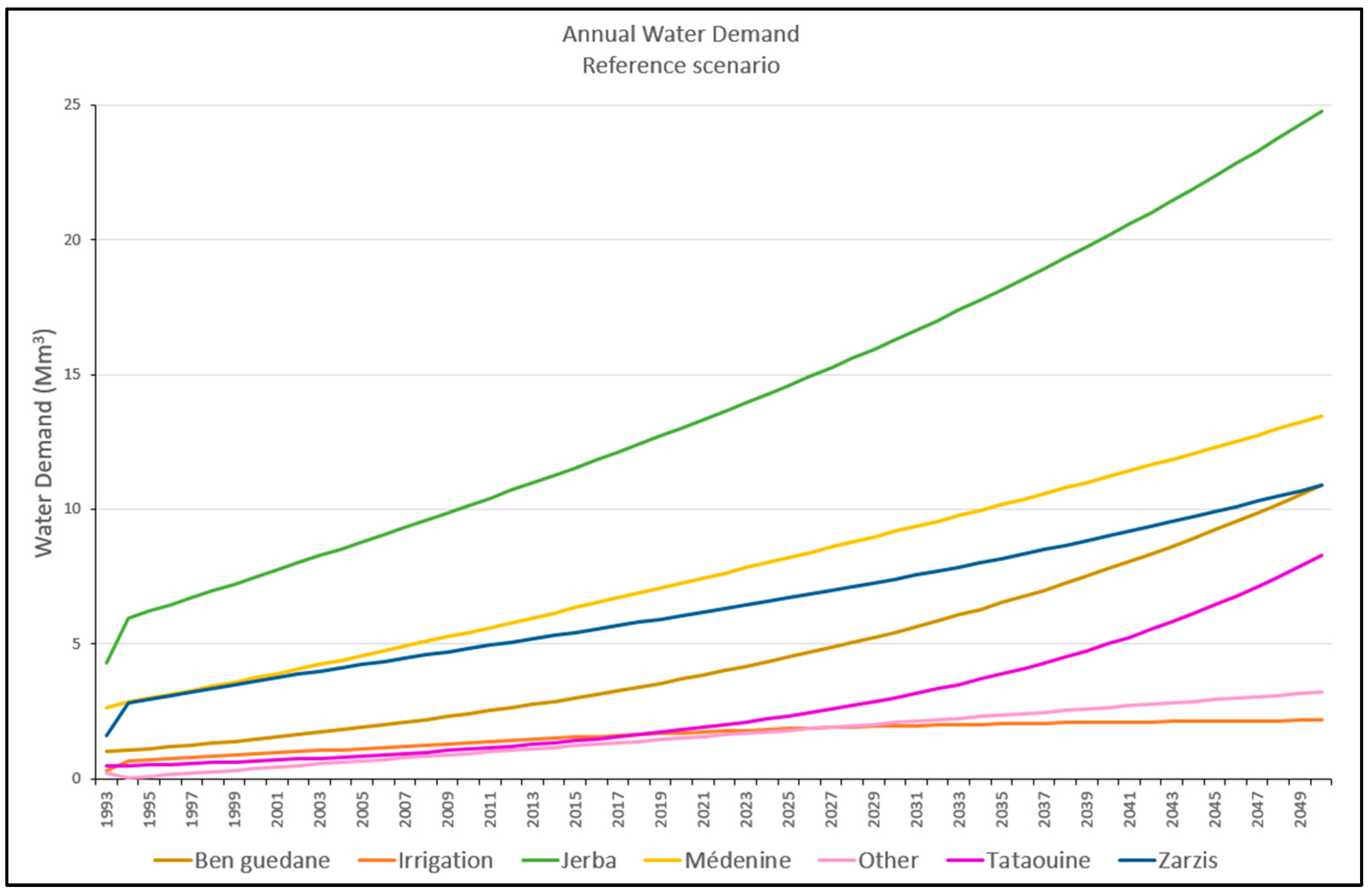
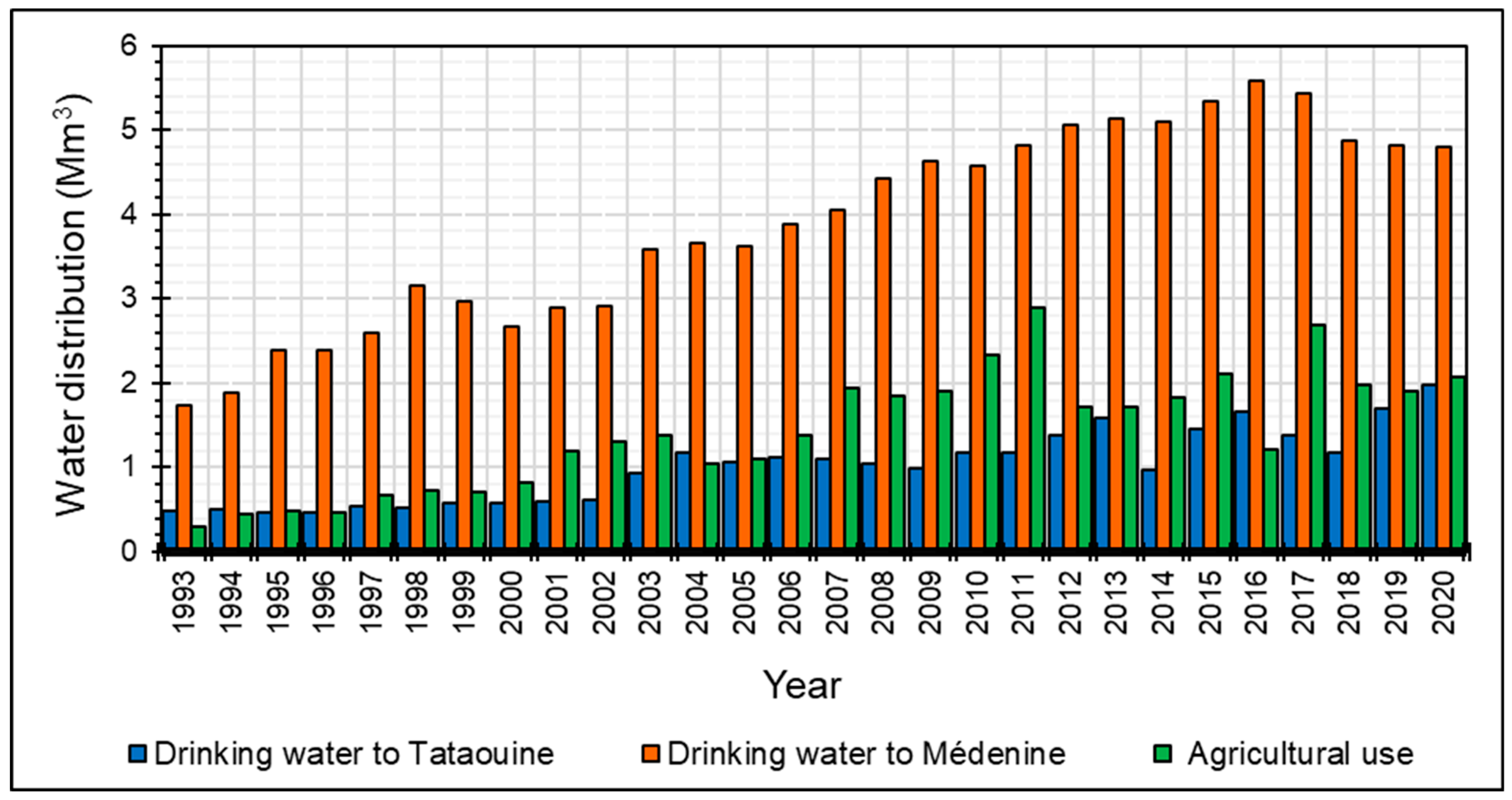
In addition to the storage parameter, the WEAP DSS provides the results of calculated demands based on the calculation of demographic development and the future evolution of specific daily consumption in the main cities of the study area.
Figure 17 illustrates the different demands calculated by the WEAP DSS.
The DSS also provides the results of calculated supplies.
Figure 18 illustrates the monthly direct recharge contributing to the Triassic aquifer through the soil profile, based on the adopted recharge hypothesis.
Figure 19 provides, as an example, the estimated indirect recharge by infiltration in the wadi beds of the Koutine watershed following the adopted recharge hypotheses.
3.3. Climate Change Scenarios
Two climate change (CC) scenarios are developed in this study under the reference conditions: the RCP 4.5 scenario (SC1.0) and the RCP 8.5 scenario (SC2.0). According to SC1.0, the decline in the storage of the Triassic aquifer begins in 2021, with a total annual difference in storage from the reference SC0 of 16.16 thousand m
3, which would reach 0.388 Mm
3 by 2050. Similarly, under SC2.0, the total annual difference in storage from the reference is estimated at 18.05 thousand m
3 in 2021, increasing to 0.414 Mm
3 by 2050. In summary, the reduction in precipitation under future climate change scenarios by 2050 results in a significant decrease in the storage of the Triassic sandstone aquifer. However, the impacts are comparable between the two climate change scenarios. By 2050, the aquifer’s capacity is projected to be 23.71 Mm
3 under the reference scenario. Under the climate change impact, it would lose more than 99% of its initial storage capacity under both CC scenarios SC1.0 and SC2.0, representing a decrease of approximately 98% compared to the reference scenario in 2050.
Figure 20 illustrates the annual change in groundwater storage under the influence of the climate change scenarios, relative to the reference scenario SC0.
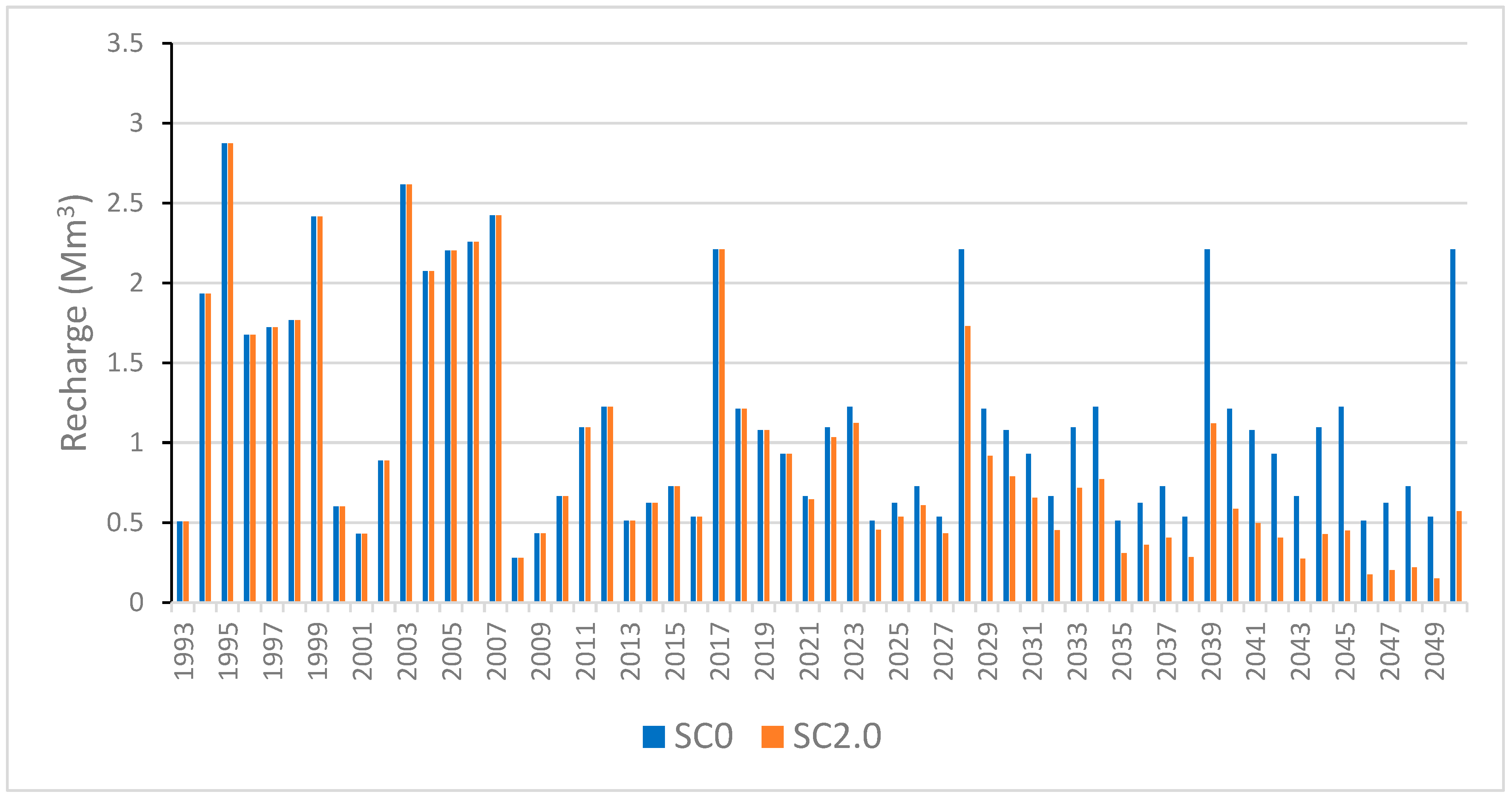
Owing to WEAP, we can also illustrate the impact of climate change on the estimated aquifer recharge. An example is provided in
Figure 21, demonstrating the recharge through runoff infiltration in the Wadi El Hallouf (Koutine watershed). The effects begin to manifest slightly from 2028, with a gradual increase corresponding to the decline in precipitation under the SC2.0 scenario, particularly around 2050.
3.4. Zarat Seawater Desalination Plant Scenarios
The reference scenario integrates the used water resources up to the year 2020 in the Médenine governorate. The present scenario, called (SC3.0), contains the projected Zarat seawater desalination plant, coming into service in 2024. It will have a capacity of 50,000 m3/d, which would be doubled to 100,000 m3/d in the year 2035. The (SC4.0) scenario is describing the extension of this plant.
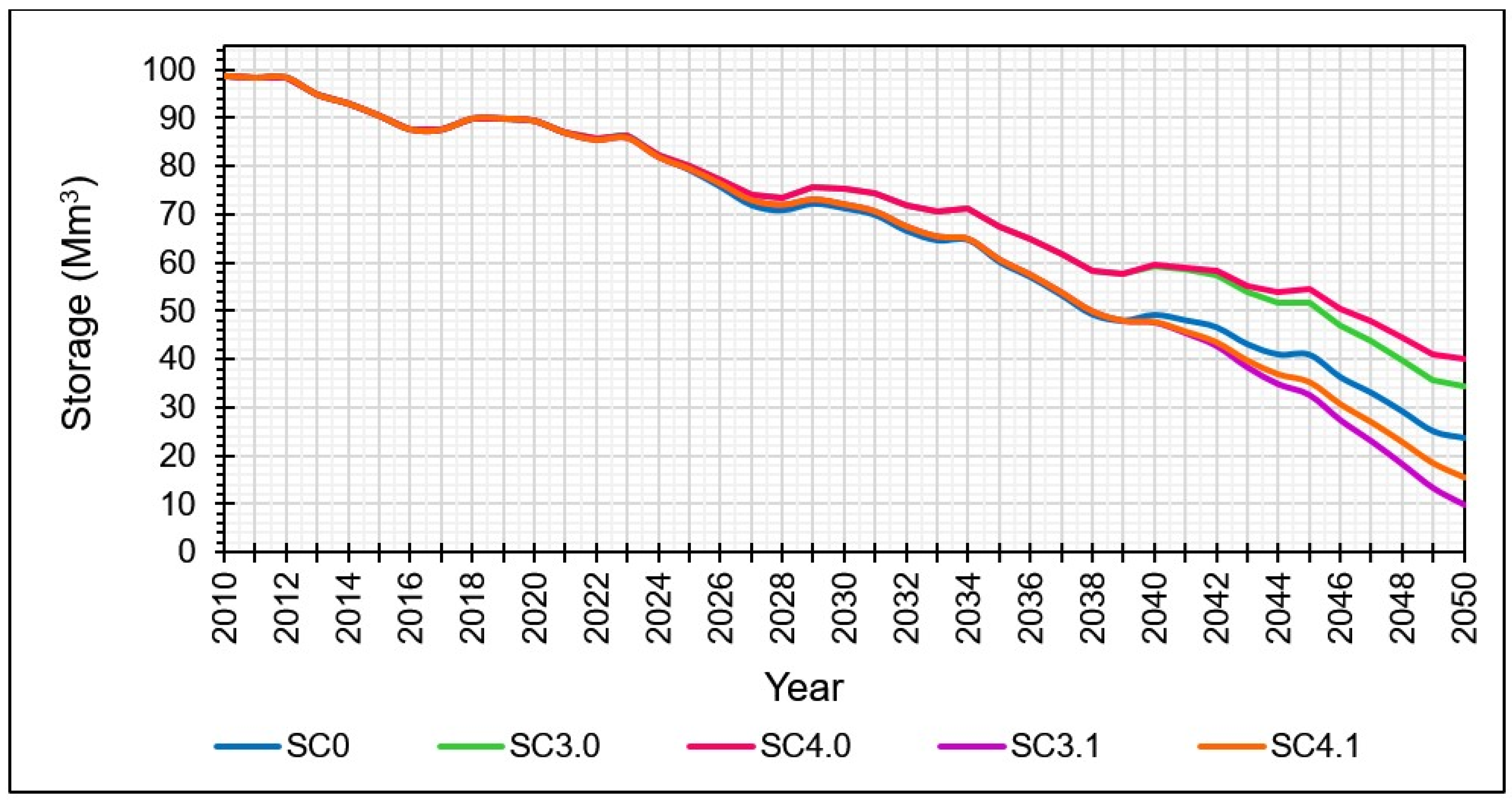
The implementation of the Zarat seawater desalination plant would cause an improvement in the water resources of the Triassic sandstone aquifer, as shown in
Figure 22. The aquifer storage would increase from an estimated volume of 23.71 Mm
3 in 2050 according to the reference scenario SC0 to 34.4 Mm
3 according to the (SC3.0) scenario, marking an improvement of 45.1% at the end of the simulation period and according to SC0.
To highlight the CC impact on the groundwater resources, the same scenario was studied under the medium CC and with the same resources (SC3.1); the aquifer storage would reach only 9.85 Mm3, marking a decrease of 58.46% at the end of the simulation period according to the reference SC0.
Under the (SC4.0) scenario, which describes the extension of the Zarat station, the changes on the aquifer storage would start manifesting clearly from the year 2040. The storage of the Triassic sandstone aquifer would be estimated at 40.2 Mm3 for the year 2050 with an estimated improvement of 69.55%.
Unfortunately, under the medium CC and with the same resources (SC4.1), the storage would be estimated at 15.52 Mm3 for the year 2050 with an estimated decrease of 34.54% referring to SC0.
WEAP is able to give distributed volumes for each demand site.
Figure 23 presents, as an example, the distributed volumes of drinking water to the Tataouine demand site under (SC3.0) and (SC4.0) scenarios. The same volumes are distributed for the scenarios (SC3.1) and (SC4.1). Thus, in 2050, the volume of water delivered to Tataouine would be estimated at 2.4 Mm
3 under the reference scenario (SC0). It would be 5.6 Mm
3 under the (SC3.0) scenario and about 8.3 Mm
3 under the (SC4.0) scenario.
3.5. WHT Impact Scenarios
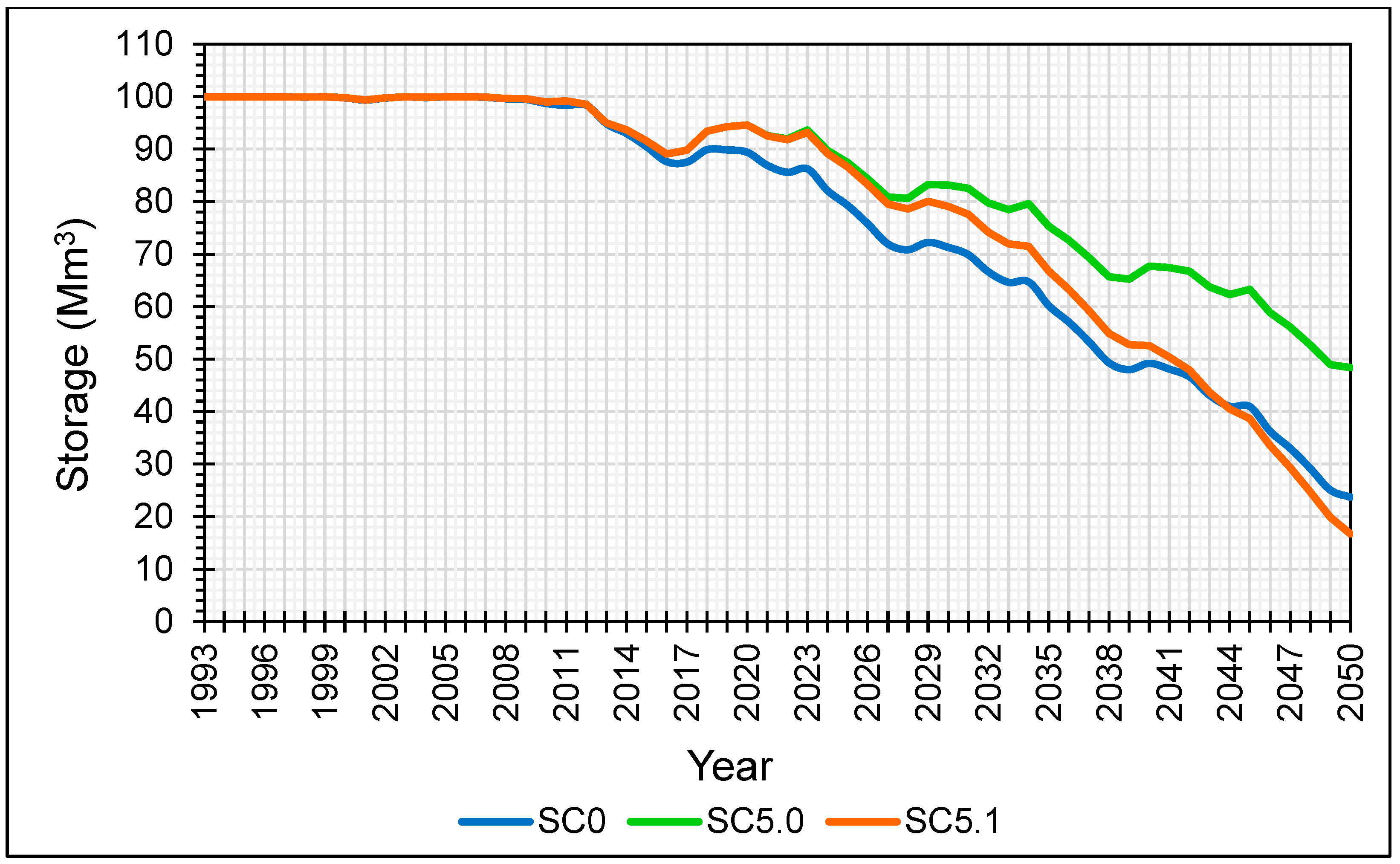
A maximum recharge rate from runoff in the wadi beds was attributed in the reference scenario (SC0) for the period from 1995 to 2010, which corresponds to the period of achievement of the water harvesting techniques (WHTs). From this date (2010), a reduction of 80% was assigned to these rates to show the effect of poor maintenance of these works. The present scenario (SC5.0) studies the case where these WHT structures would maintain their efficiency during the simulation period; this means that indirect recharge rates would remain maximum from 1995 until 2050.
Figure 24 shows the annual evolution of the Triassic aquifer storage under (SC0) and (SC5.0) scenarios. It shows that the difference began to appear in the year 2011, with low values (an improvement in storage of 0.81 Mm
3 in 2011). The storage would pass from 23.71 Mm
3 to 48.4 Mm
3 for the year 2050, marking an extra accumulated storage at the end of the simulation period of 24.7 Mm
3. This is expressed by an increase of 104% compared to the (SC0) scenario and for the same year 2050. This improvement represents approximately 25% of the initial storage capacity of the Triassic aquifer. This leads us to say that the WHT, in the case of their efficiency and their proper maintenance, is responsible for providing the quarter of its storage.
The same figure shows the evolution of the WHT scenario under the CC RCP 4.5 (SC5.1). The impact of CC on the WHT role is expressed by a decrease in the recharge and by a decrease in the storage aquifer by the year 2050. It would be 16.7 Mm3, showing a decrease of 29.56% compared to the (SC0) scenario.
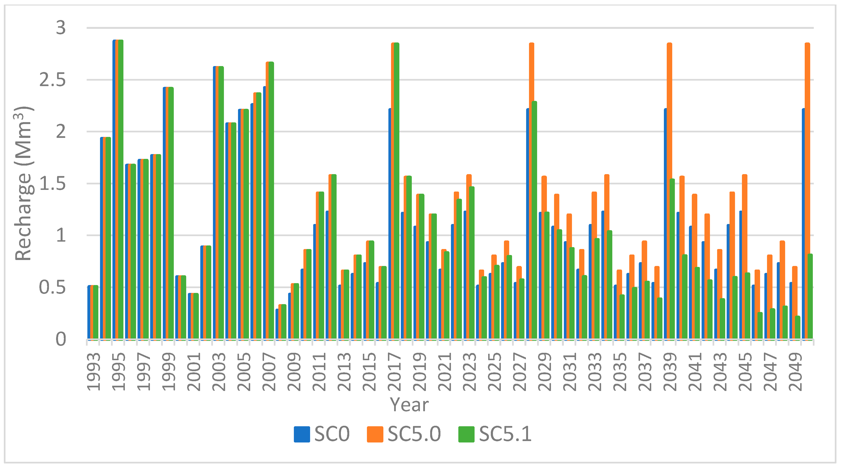
As an example,
Figure 25 shows the difference in the recharge in the Wadi El Hallouf bed, representing the Koutine watershed in this WEAP project, between the reference, the SC5.0, and the SC5.1 scenario; it shows a decline in recharge linked to the CC. For the year 2050, the recharge in the Koutine watershed would decrease from 2.8 Mm
3 under SC5.0 to 0.8 Mm
3, as example.
These results highlight the crucial role of WHT in sustaining aquifer storage, as their proper maintenance ensures significant long-term benefits, while climate change under RCP 4.5 reduces their effectiveness, leading to a notable decline in storage.
3.6. Irrigation Scenarios
The “Irrigation” demand site, which represents the agricultural demands, consumes 1.7 Mm
3 in 2020, which could reach 2.2 Mm
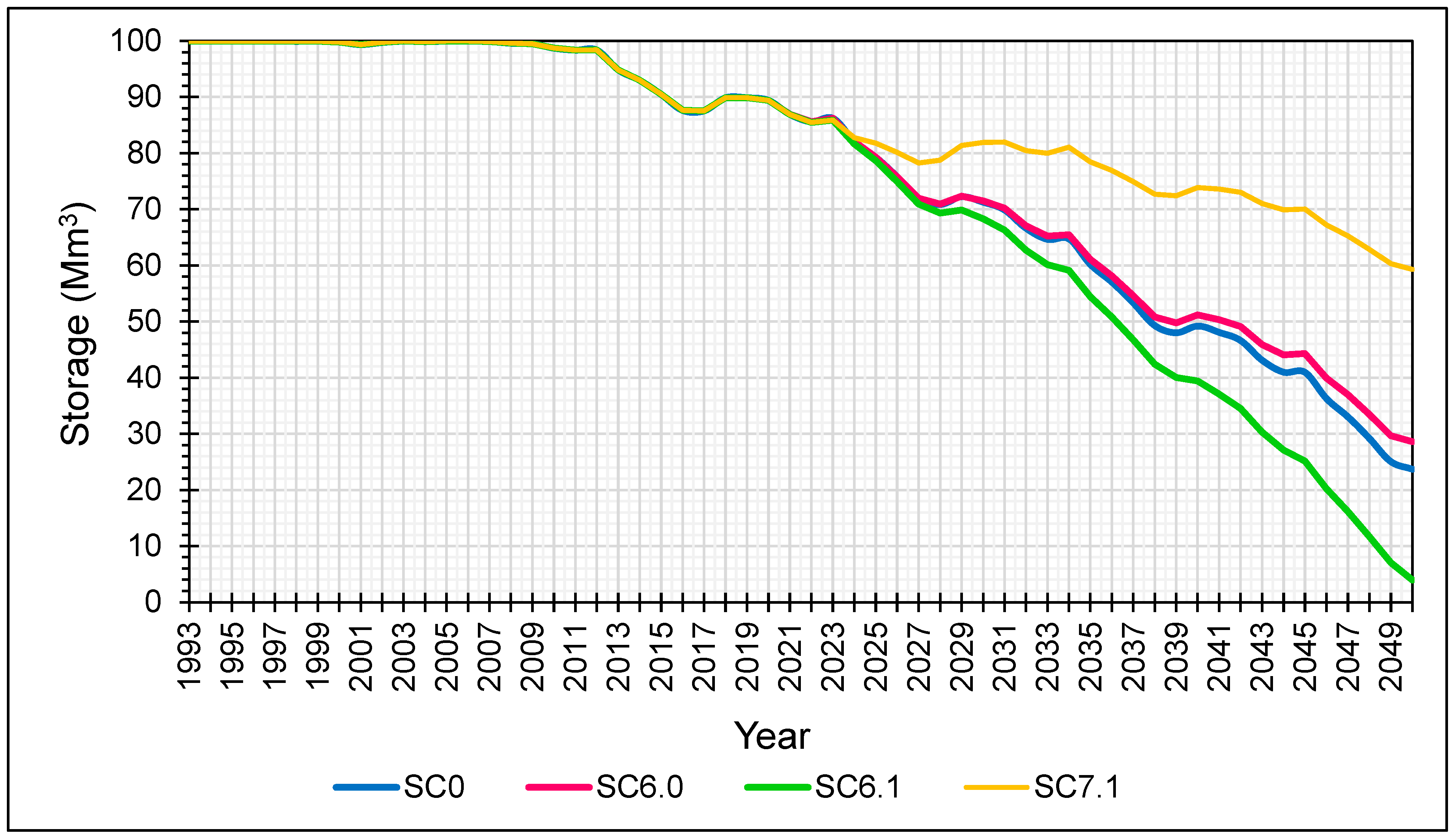
3 by 2050 by increasing at the same rate, according to WEAP estimates. The present scenario assumes the stability of the Triassic aquifer water demand destined to agriculture since there is a serious motivation from the services responsible to install a treated wastewater station in the study region to use for the irrigation. This stability of agricultural consumption is assumed to start in the year 2027 and the scenario is called (SC6.0).
Figure 26 shows the evolution of the annual Triassic aquifer storage calculated by WEP DSS under the reference scenario SC0 and the (SC6.0) scenario. It shows an increase of 4.9 Mm
3 of the Triassic storage aquifer, showing an improvement of 20.67%. Under the CC scenario, the present scenario called (SC6.1) would give a reduction of 24.66 Mm
3 of the Triassic storage aquifer, showing a decline of 83% compared to the reference conditions.
While the SC7.1 scenario may appear unrealistic, it highlights the substantial impact of irrigation on the aquifer. This “Irrigation Cancellation” scenario reveals a significant influence on aquifer storage. As shown in
Figure 26, the annual evolution of the Trias aquifer’s storage under SC7.1 becomes noticeably different starting in 2025, with an initial improvement of 1.1 Mm
3. By 2050, the aquifer’s storage is projected to be 59.3 Mm
3 under SC7.1 showing an improvement of 36 Mm
3 (250%) compared to the reference scenario. This result reflects the heavy reliance of the aquifer on irrigation withdrawals and suggests that reducing or optimizing irrigation could significantly enhance groundwater storage, emphasizing the need for sustainable water management practices. It serves as a stark warning to policymakers about the detrimental effects of irrigation on groundwater resources in the Médenine region, highlighting the urgent need to adopt alternative water sources, such as treated wastewater from wastewater treatment plants, to ensure long-term water sustainability.
3.7. Aquifer Recovery Scenario
The studied scenario was developed by integrating SC1.0, SC3.1, SC4.1, SC5.1, and SC6.1 scenarios, along with a projected reduction in specific drinking water consumption from 130 L/d/person to 110 L/d/person by 2050, as estimated by SONEDE. Its objective is to determine the volume of water needed to restore the aquifer to its initial level. To achieve this, the WEAP DSS proposes supplementing the main demand sites of Médenine and Tataouine with an additional water supply. This supplementary supply starts at 0 in 2024 and gradually increases to fill the deficit by 2050. Calculations estimate this additional supply in 2050 at 165,041 m3/d.
This result illustrates, in
Figure 27, the projected water deficit in the region by 2050 and proposes a supplementary water supply to restore the aquifer. To provide a practical comparison, the required additional supply of 165,041 m
3/d in 2050 is roughly equivalent to the capacity of a new desalination plant (about 150,000 m
3/d) or three smaller plants (50,000 m
3/d each) as commonly used in Tunisia. These examples are meant to help interpret and visualize the volume of water needed to address the deficit.
Table 7 summarizes the results of all the studied scenarios.
4. Discussion
Modeling is a powerful tool for understanding complex systems and predicting future scenarios. However, it is essential to recognize that all models are subject to uncertainties that can influence their outcomes. These uncertainties may arise from various sources, including data limitations, assumptions made during model development, and external factors that may change over time. Acknowledging these uncertainties is crucial for accurately interpreting model results and making informed decisions.
In particular, this study relies on empirical formulas and assumptions without sufficiently addressing their uncertainties. Conducting sensitivity analyses for these parameters would help better quantify their impact on the model’s reliability and improve the robustness of the conclusions. This aspect will be further investigated in future studies on the region to refine the analysis and enhance the understanding of these uncertainties.
Furthermore, while the study is well conducted regarding the estimation of demand evolution based on population growth and specific consumption, there are uncertainties in this evolution. Indeed, there is a commitment from the responsible services to enhance efforts to reduce current specific consumption, which poses a challenging yet achievable goal.
Additionally, although the simulation period considered the highs and lows of the tourism sector, this sector is generally projected to increase in the model. The agricultural sector also experiences a gradual and normal increase in irrigated areas and irrigation flows, considering the current situation and the available species in the region. It is worth noting that the introduction of irrigated olive varieties in the last decade has increased agricultural consumption. Therefore, the uncertainty in this sector lies in the types of crops that may be grown in the future, as well as any limitations that the responsible services at the governorate level might impose on agricultural usage.
Another source of uncertainty pertains to the daily output produced by desalination plants. In fact, the daily production capacity considered in the model is not always achieved, taking into account interruptions for maintenance, breakdowns, or other unforeseen events. This capacity is achieved about 85% of the time.
Furthermore, uncertainties related to climate change scenarios also play a significant role in the modeling process. These scenarios often involve shifts in precipitation patterns, and the frequency of extreme weather events, all of which can substantially affect water availability and demand. The manuscript adopts the RCP4.5 and RCP8.5 scenarios, which are widely recognized as standard and relevant for climate impact studies. While it is true that climate projections encompass a wide range of possible futures, the choice of these two scenarios is justified by their continued use in scientific assessments and policy recommendations, particularly in the study region, where RCP2.6 is no longer considered a realistic pathway.
Additionally, while uncertainties exist in regional climate models (RCMs) and their propagation into hydrological outcomes, the selected approach ensures a balance between model complexity and practical applicability. Downscaling techniques inevitably introduce some variability, but RCP4.5 and RCP8.5 provide a reasonable representation of likely climate futures, aligning with observed trends and policy-driven expectations. Moreover, the methodology already accounts for fluctuations in precipitation and their influence on aquifer recharge, considering both interannual variability and long-term trends.
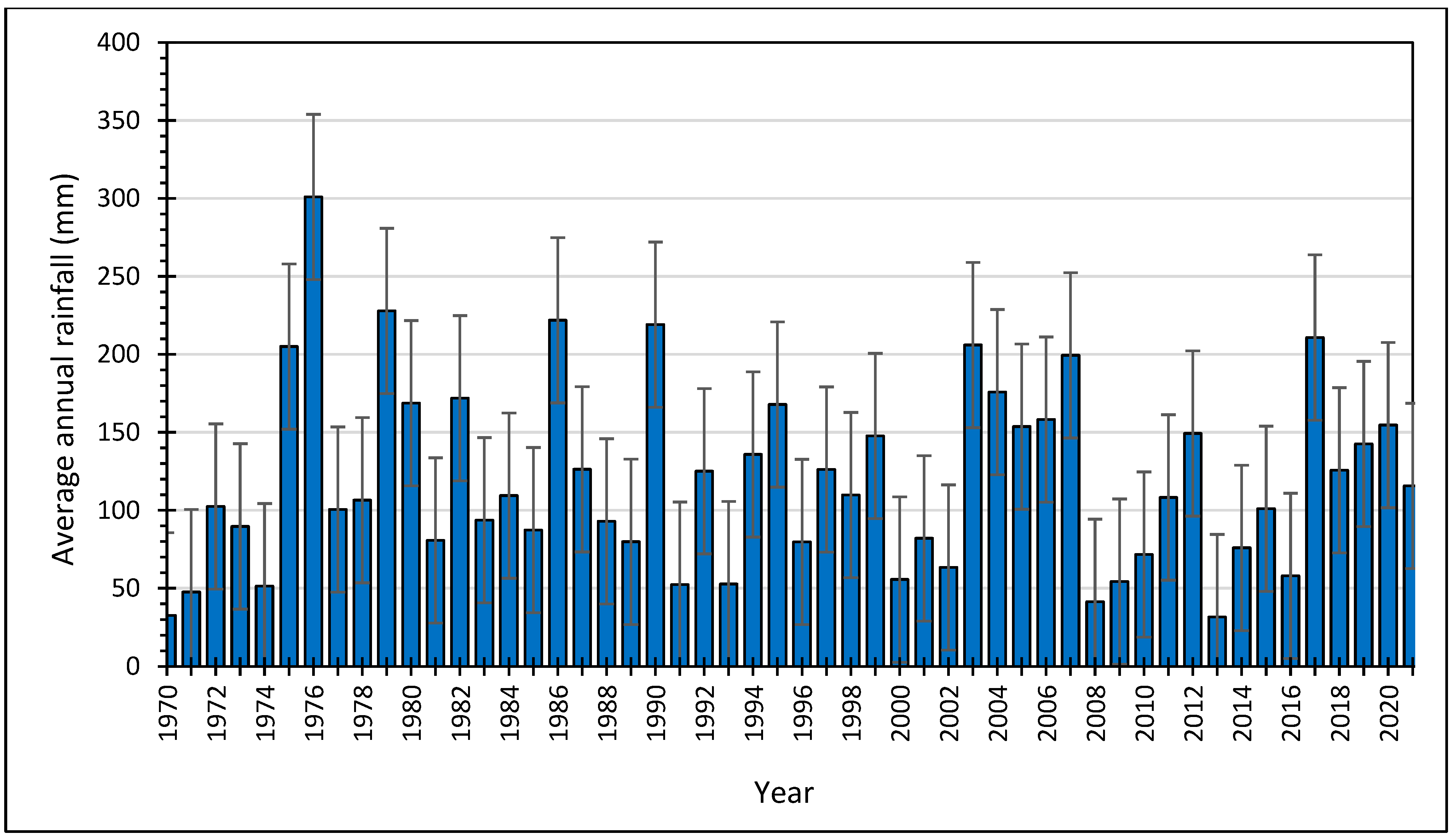
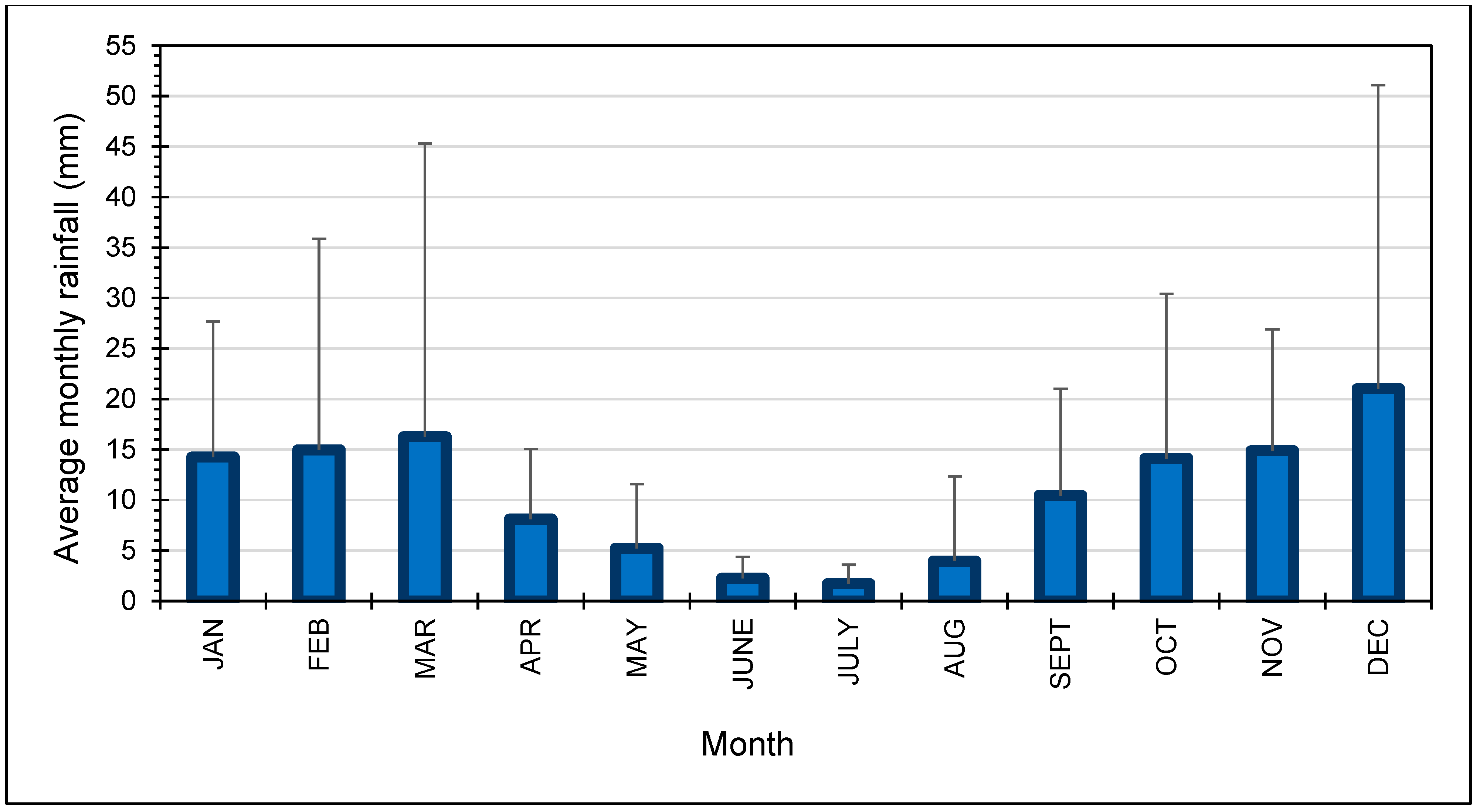
The decrease in average annual precipitation by the year 2050 is expected to be between 5% and 10% according to the RCP 4.5 scenario and between 1% and 14% according to the RCP 8.5 scenario. Although a detailed confidence interval analysis for precipitation projections could further refine the results, the core objective of the study is to assess the relative impacts of climate scenarios on water resources rather than to quantify precise probabilities. Given the inherent uncertainties in all climate models, the emphasis remains on providing a robust yet interpretable framework for water resource planning.
As climate change progresses, the potential impacts on both the agricultural and tourism sectors may lead to unforeseen shifts in resource requirements and consumption patterns. However, by integrating well-established climate scenarios and reflecting observed trends, the model remains a valuable tool for guiding water management strategies. Future updates can incorporate evolving climate projections as more refined data become available, ensuring the continuous relevance of the approach.
In addition to the limitations related to data availability, a notable limitation is the exclusion of certain critical factors—such as water quality and ecological impacts—from the analysis. Water quality is essential for evaluating the sustainability of water resources, while understanding ecological impacts is vital for assessing the broader environmental consequences of water management practices. These important factors could be the focus of future research, allowing for a more in-depth analysis while maintaining the conciseness of this manuscript and preventing the results from becoming overly complicated.
In summary, while modeling serves as a vital instrument for analyzing complex systems and forecasting future scenarios, it is imperative to acknowledge the inherent uncertainties that accompany these models. These uncertainties must be considered in the future and updated as necessary to improve the model’s accuracy and reliability.
Adopting the above results, during the simulation period (1993–2020), the total recharge was varying from a minimum value of 1 Mm
3/year to a maximum value of 7 Mm
3/year, while the recorded total demands were varying from 4.5 to 7 Mm
3/year for the same period. During the forecast period (2020–2050), total recharge of the Triassic aquifer would be varying from 0 Mm
3/year as the minimum forecasted value to a maximum of 4 Mm
3/year according to both RCPs (Representative Concentration Pathways): RCP4.5 and RCP8.5 CC scenarios. Thus, the total demands for the Médenine and Tataouine cities, which are supplied with about 30% from the Triassic aquifer, would be varying from 23 Mm
3 in 2021 to a maximum forecasted demand of 74 Mm
3 in 2050. These values translate the deficit report of the water supply and demand balance. In fact, the Tunisian population’s average specific consumption estimated for 2020 is about 130 L/day/inhabitant [
57], which is comparable to some other European countries having abundant resources (130 to 160 L/day/inhabitant for Denmark and 140 to 160 L/day/inhabitant for France).
The lack of precipitation and the sharp increase in water demand compared to the recharge would cause an overexploitation of the Triassic aquifer water resources and the situation is estimated to get worse especially with future climate change.
There is a willingness from the responsible services to reduce consumption around 2050 to 110 L/day/inhabitant, which is introduced in the WEAP DSS as a scenario, considering all available and projected resources. The simulations illustrate that building and increasing desalination plant capacity can substantially improve the Triassic aquifer behavior. These findings highlight the importance of continued investment in desalination infrastructure to enhance water availability. Unfortunately, all these efforts are insufficient to relieve the aquifer and restore its initial level. To achieve this purpose, and to satisfy these growing demands without damaging only the Triassic aquifer, three seawater desalination plants (SDPs) are needed, like those often used in Tunisia in Jerba, Sfax, Sousse, and Zarat, with a capacity of 50,000 m
3/d. It is to be noted that the Zarat SDP cost 371 million Tunisian dinars (118 million US dollars) [
57]. These findings highlight the seriousness of water scarcity in Tunisia to act deeply within society to ensure the sustainability of these resources, through awareness-raising and prevention efforts.
While seawater desalination is often presented as a viable solution to water scarcity, it is essential to consider its potential environmental and economic impacts. The process requires significant energy input (2.6 kWh/m
3) [
57], often relying on fossil fuels, which can contribute to greenhouse gas emissions and climate change. Additionally, the disposal of concentrated brine (a byproduct of desalination) can harm marine ecosystems by increasing salinity levels and introducing chemical residues. In Jerba, the desalination plant alone discharges approximately 58 tons of saline solution per day. From an economic perspective, desalination infrastructure and operational costs can be substantial, making it a less feasible option for regions with limited financial resources. Therefore, while desalination can provide a reliable water source, a comprehensive assessment of its sustainability and long-term viability is crucial.
On the other hand, assuming that irrigation from the Trias aquifer ceases starting in 2025 would result in a 250% increase in aquifer storage compared to the reference scenario, with storage projected to reach 59.3 Mm3 by 2050. It is important to note that irrigation accounts for 25% of the total demand on the Triassic aquifer in Sahel El Ababsa. These findings underscore the urgent need to identify alternative water resources for irrigation, such as treated wastewater from wastewater treatment plants, to reduce reliance on the aquifer and promote sustainable water management.
The traditional water harvesting techniques (WHTs) in this region, including recharge wells, play a crucial role in sustaining water availability. However, poor maintenance has led to clogging and reduced efficiency, threatening their long-term effectiveness. To ensure sustainability, regular monitoring and community-based management strategies are essential. Implementing maintenance plans, training local stakeholders, and integrating modern filtration techniques, such as upstream filtration systems and sedimentation basins, can help preserve these structures and enhance groundwater recharge. Additionally, using vegetation to stabilize soil and reduce erosion can further minimize sediment transport to recharge wells. Proper management is key to maximizing the benefits of WHT and securing water resources for future generations.
In fact, the implementation of desalination and water harvesting technologies faces several socio-economic obstacles that can hinder their effectiveness and sustainability. One significant challenge is funding, as the initial capital investment required for these technologies can be substantial, often exceeding the budgets of local governments or organizations. Additionally, ongoing operational and maintenance costs can strain financial resources, particularly in regions with limited economic capacity. Furthermore, the necessity for community engagement cannot be overstated; local communities must be involved in the planning and decision-making processes to ensure that these technologies align with their needs and priorities. Without community support and understanding, there is a risk of resistance or lack of participation in water management initiatives, ultimately undermining the success of desalination and water harvesting projects. Addressing these socio-economic barriers through collaborative approaches, transparent funding mechanisms, and educational outreach is crucial for fostering the long-term viability of these water supply solutions.
In this context, the expansion of WHT policies in the region has demonstrated promising socio-economic benefits, particularly in creating rural employment opportunities and enhancing quality of life through increased agricultural land cultivation. Economically, WHT measures have positively influenced primary production and infrastructure development, although a transition from primary production to off-farm employment has not yet materialized [
78]. On the other hand, the implementation of the seawater desalination plant in Djerba has improved the quality of drinking water on the island and reduced pressure on groundwater resources, particularly the Zeus Koutin aquifer. This has had positive effects not only on Djerba but also on neighboring areas such as Ben Guerden and Zarzis. Socio-economically, this improvement in the drinking water supply has helped meet the growing demands of the local population, particularly in response to the increased water demand [
79].
Numerous studies have utilized WEAP to explore the dynamics of water supply and demand under various WRM scenarios. This paper represents one of the first studies on the management of aquifer recharge through non-conventional water using WHT. Yao et al. [
80] applied WEAP to assess water availability in the Lobo watershed in central–western Cote d’Ivoire, for the years 2016–2040. Their findings indicate that rice irrigation accounts for 44% of total demand, followed by urban water supply at 30.8%. Demand projections suggest that water deficits observed in the baseline scenario will rise to 100.45 million m
3 by 2040. Under the “climate change” scenario, unmet water demands are comparable to those of the baseline. To address these deficits, optimization scenarios were analyzed, showing that building dams to enhance urban water supply and reducing irrigation water consumption and losses could significantly alleviate shortages.
According to Al-Mukhtar and Mutar [
30], Iraq faces severe water scarcity due to upstream water policies, population growth, economic expansion, and climate change. Their study focuses on optimizing water allocation for domestic, agricultural, and industrial sectors in Baghdad under current and future scenarios using the WEAP model. Future scenarios (2020–2040) included varying population growth rates, reduced river discharges, and combined stressors. Results showed unmet water demand and supply across all scenarios, highlighting the urgent need for sustainable water management strategies in Iraq [
30].
Ayed et al. [
81] developed a decision support framework for water resource modeling using WEAP to evaluate the following: (i) groundwater spatial management using GIS-based quality and vulnerability maps for the Maritime Djeffara, classifying the area into zones of good, moderate, and unsuitable water for human use, and (ii) groundwater quantity management by balancing reserves and demands and projecting future water scenarios using the WEAP21 model. Three scenarios—“Irrigation water needs”, “Population growth rate”, and “Industry growth rate”—were simulated. Results indicate significant water demand increases, with the “Irrigation water needs” scenario showing the greatest impact, reducing groundwater reserves from 10,760 Mm
3 (2015) to 10,324.77 Mm
3 (2065) due to overexploitation and limited recharge. Demand management policies are recommended to restore supply–demand balance.
Touré et al. [
82] analyzed the future behavior of groundwater resources in the Klela Basin, Mali, a key water source for domestic use, irrigation, and livestock, as well as the city of Sikasso. Using the WEAP model, they assessed the impact of socio-economic and population growth scenarios alongside RCP4.5 and RCP8.5 climate projections. Their results indicate a significant decline in groundwater recharge (49%) and storage (24%) by 2050, with the most critical reductions occurring in the 2030s, potentially triggering severe agricultural droughts. These findings highlight the increasing vulnerability of groundwater resources under climate change and emphasize the need for proactive water management strategies to safeguard irrigation and freshwater supply.
Berredjem et al. [
83] employ the Water Evaluation And Planning (WEAP) system to evaluate current and future water supply and demand under five scenarios: reference, climate change, desalination, leakage reduction, and water reuse. By 2070, water demand is projected to reach 148 Mm
3, with climate change further increasing it by 8% to 151 Mm
3. The industrial sector experiences the highest unmet demand, followed by domestic and agricultural sectors. Desalination and water efficiency measures show potential for fully meeting industrial needs, while managed aquifer recharge (Scenario 5) reduces industrial deficits by 36%, and leakage reduction with water reuse (Scenario 4) decreases unmet domestic demand to 24 Mm
3. The findings highlight the urgent need for integrated water management strategies, including infrastructure investment, conservation efforts, and the adoption of efficient technologies across sectors.
The comparison of this study with other WEAP-based research in arid regions reveals common challenges and key differences in water management strategies. Similar to findings from Toure et al. [
82] in Mali and Berredjem et al. [
83] in Algeria, this study confirms the significant impact of climate change and increasing demand on groundwater depletion. However, while desalination and leakage reduction were effective mitigation measures in Algeria, water harvesting techniques showed a more substantial improvement in groundwater storage in Tunisia. Additionally, unlike Ayed et al. [
81] in the Maritime Djeffara, where irrigation demand was the dominant driver of groundwater depletion, this study highlights the compounded effects of climate change on storage reduction. These findings underscore the need for region-specific strategies, integrating demand-side management, alternative water sources, and policy interventions to enhance resilience against future water scarcity.
5. Conclusions
The study area concerns the Triassic aquifer of Sahel El Ababsa in Médenine, southeast Tunisia. It is characterized by an arid climate with a deficient water balance throughout the year. The exploitable resources of the aquifer are estimated at 8.7 Mm
3/year with an equivalent flow of 276 L/s [
47]. The water exploitation index (WEI) started with lower values (25%) in 1993 and it continued increasing to reach 78% in 2020. The estimated initial storage capacity is 100 Mm
3.
The aim of this study is to develop a DSS to help manage the Triassic aquifer using the WEAP model. Two Triassic aquifer WEAP models are built, the initial one, M1, containing only the Triassic aquifer, its catchment, and the demands. This model M1 is based on observed demands during the simulation period from 1993 to 2020. The final one, M2, is a Triassic aquifer model integrated in the Médenine governorate hydro-system WEAP model [
31,
32,
64]. The test validation is made by comparing the two WEAP models results using the coefficient of determination R
2. The calculated R
2 is equal to 0.9.
However, due to the water blending strategy adopted by the National Water Exploitation and Distribution Company (SONEDE), where water from multiple sources is mixed in reservoirs before redistribution, it is challenging to calibrate the model using distributed volumes. Therefore, a comparison between the recorded pumped volumes from the Triassic aquifer to the reservoirs and the calculated flow rate, which represents the water demand of the Médenine demand site from the Triassic aquifer, shows an R2 value of 0.86.
Both results contribute to validate the final WEAP model of the Triassic aquifer based on the estimation by WEAP of the supply and demands. The resulting updated model will be used after validation as a decision support system (DSS) enabling informed decision-making and optimized planning for future climate change (CC) and water resources management (WRM) scenarios.
The model is a monthly time step, and the simulation period ranges from 1993 to 2020 and continues with a forecast period to 2050. The reference scenario supposes that climatic conditions and WRM are maintained as those of the year 2020.
Two CC scenarios are developed based on the RCP4.5 and RCP8.5 projections for the year 2050 (SC1.0, SC2.0). It shows that the aquifer would lose more than 98% of its initial storage under both CC scenarios. A new seawater desalination plant in Zarat city, in the northern limit of the governorate of Médenine, should start working in 2024 with a capacity of 50,000 m3/day. This plant is intended to supply partly the governorate of Médenine and the governorate of Tataouine. It would have double production in 2035. Two scenarios were developed describing the implementation of the plant and then its extension under the reference (SC3.0, SC4.0). The implementation of the Zarat seawater desalination plant (SC3.0) would cause an improvement in the water resources of the Triassic sandstone aquifer of Sahel El Ababsa. The aquifer storage would increase from 23 Mm3 in 2050 estimated according to the reference scenario to 34.4 Mm3, marking an improvement of 45% at the end of the simulation period. The storage of the Triassic sandstone aquifer under the extension of the plant scenario (SC4.0) would be estimated at 40.2 Mm3 for the year 2050 with an estimated improvement of 69.5% compared to reference conditions. According to the medium CC, these results would decrease, and they would be 9.8 (a decrease of 59% compared to the reference) and 15.5 Mm3 (a decrease of 35% compared to the reference), respectively, under SC3.1, SC4.1.
Two scenarios studied the importance of the water harvesting techniques (WHTs) on the groundwater recharge under reference and CC conditions (SC5.0, SC5.1). The SC5.0 showed an improvement of 104% compared to the reference scenario and the storage would increase from 23 Mm3 to 48.4 Mm3 for the year 2050. This improvement represents approximately 25% of the initial capacity of the Triassic aquifer. The CC, in the SC5.1 scenario and for the same year, is responsible for a decline of about 29% of the Triassic storage compared to the reference and the storage would be 16.7 Mm3.
The scenario describing the stability of all agricultural demands from the Triassic aquifer from the year 2027 showed an increase of 4.9 Mm3 of the Triassic storage aquifer, marking an improvement of 21.3%. The SC7.1 scenario, describing the “Irrigation Cancellation” from the Triassic aquifer demonstrates a significant influence on aquifer storage. The aquifer’s storage is projected to reach 59.3 Mm3 in 2050 with an improvement of 36 Mm3 (250%) compared to the reference scenario.
These results confirm the importance of both the WHT and the seawater desalination plant to face the increasing demands and the future CC conditions. Therefore, it is recommended to encourage the installation and the maintenance of WHT, which are considered an integral part of the country’s national heritage [
84], in order to improve groundwater recharge during rainy years.
On the other hand, it is crucial to prioritize awareness campaigns aimed at reducing water consumption, which is escalating at an alarming rate. This increase is driven by significant population growth, urbanization, the expansion of the tourism sector in the study area, and, most critically, a lack of awareness about the severity of the water crisis. Additionally, these findings underscore the urgent need to implement alternative water resources for irrigation, such as treated wastewater from wastewater treatment plants, to promote sustainable water management and to safeguard the aquifer.
