Abstract
The continuous processes of mining development, since the very beginning of Minas Gerais State’s development, have been giving new attention and meaning to valuable pre-existing features (i.e., cultural, social, and physical-environmental), impacting and recharacterizing not only its municipalities but their essential local or native sociocultural components. At the same time, mining, as one of the central pillars of the Brazilian development model, has put different communities, natural and cultural heritage, and mineral and water resources at risk. The wide concept of geodiversity and the related geoheritage emerge as an alternative for conservation, territorial planning, and sustainable development, to reconcile these spheres. This study developed a comprehensive framework for geoconservation within selected areas of mining landscapes, contributing to insights for the creation of a catalog about geoheritage in the state of Minas Gerais, discussing and analyzing well-established strategies and opportunities based on UNESCO Global Geoparks (UGGp) and the GEOfood brand. We concluded that the mining landscapes of Minas Gerais must be administered as a viable possibility for economic and environmental dynamic actions and activities, strengthening the maintenance of municipalities from the very beginning to after the end of operational activities. Heritage programs such as UGGp and GEOfood enable knowledge sharing and engagement with geoheritage, improving the comprehension and management of the short- and long-term impacts of mining, while elevating geodiversity as a major source of information in the “greening” of mining policies.
1. Introduction
Globally, Brazil is among the five largest mineral producers, with the mining sector representing approximately 8% of the Brazilian Gross Domestic Product (GDP) [1]. Located in Southeastern Brazil, Minas Gerais (MG) is the largest ore-producing state, representing 47.01% of national production and houses ¼ of the largest Brazilian mines [1]. The state is home to 482 municipalities that depend, almost exclusively, on taxes and jobs generated directly or indirectly by the sector (more than half of the total number of municipalities in the state), but the sector only constitutes 4% of the state’s GDP [1,2]. Historically, the discovery of minerals (i.e., gold and ore) in MG started with the Portuguese exploration more than 400 years ago and changed the entire political, economic, social, cultural, and religious scenario of colonial Brazil [3]. Those mining activities outlined regulations for different types of operations and guidelines for the nation’s economic development as the countryside was being rapidly populated, transforming and molding the landscapes. The mining identity is considered a symbolic landmark for the state and is even included in its name (in Portuguese, “minas” means “mines”). In 2021, the state had the largest increase in the royalty collection and is also the one that will attract most of the investments for the sector until 2025 (approximately 10.2 billion USD) [1]. In a certain way, mining activities boosted Brazil’s economy and are globally recognized today as essential for economic development and well-being [4]. However, there are many controversies over how mining is practiced all over the world, particularly in Brazil and economically developing countries.
In general, mining, as one of the central pillars of the Brazilian development model, has put natural and cultural heritage, and mineral and water resources at risk [5]. These territories—where the extraction and processing of minerals take place—are often the scene of social and environmental crimes and challenges (e.g., climate change, social and administrative conflicts, landowners), as well as the degradation of natural resources through deforestation, pollution, and, most recently, by the two major tailing dam catastrophic failure tragedies in the country’s mining history. The events that occurred in the municipalities of Mariana (in 2015) and Brumadinho (in 2019) left hundreds of deaths, destruction in different communities, and expressive damage and pollution to the environment [5,6]. Furthermore, debates and investigations around the importance of the sector for the country’s economy were reignited, trying to find out how dependent the state is on mineral activities and which ones are responsible for the crimes that occurred [5,7]. Internationally, 84% of the top 25 ranked countries producing mineral resources are rated as weak, poor, or failing in terms of the quality of their extractive sector governance. Considering MG, statistics have shown expressive poverty rates in large-scale mining municipalities, suggesting that there is a lot of room for the improvement of socioeconomic benefits from the local mineral resources and public policies [8,9,10]. Additionally, mining operations repeatedly ignored the widely perceived intrinsic natural and sociocultural values of the environment that was once there [7,11].
Furthermore, Brazil, and specifically MG, has great potential in terms of geodiversity, with studies showing the country among the top five in scientific contributions related to the variety of elements and values of abiotic nature [12]. In the last two decades, approaches related to nature conservation, territorial planning, and sustainable development have been gaining a new look with the term geodiversity [13,14,15]. According to Gray [16], geodiversity is creating a multifaceted and evolving concept, comprehending the wide range of geoscientific paradigms or the ‘Gs’ (i.e., geology, pedology, geomorphology, geosystem services, geoheritage, and geotourism). Rooted in the ‘Gs’ framework [17], we structured a possible geoconservation framework for mining landscapes (Figure 1), progressing from geodiversity components, which include their assemblages, structures, systems, and contributions to landscapes, to how mine development has been shaping landscapes, thus creating the mining landscape. This “recently molded place” was the subject of an intensive mining process, upbringing new values and meanings, giving new attention to different aspects of the sociocultural, economic, and environmental contexts, and emphasizing the capital value attributed to mineral resources [18]. This area, under the operations of a company or enterprise, is now a complex engineering work that not only comprises sources of industrial activities (i.e., infrastructure, facilities, machinery, and open pits) but also many elements of earth’s abiotic nature that have considerable scientific, sociocultural, historical, and/or aesthetic values, the so-called geoheritage. Moreover, the exceptional values attributed to geoheritage elements are usually protected under several forms of instrumentalities and laws. Therefore, an alternative, systematic approach is needed for reconciling conservation activities, territorial planning, and sustainable development. Within the geoconservation framework, three types of efforts emerge as crucial elements: (i) systematic inventory of geodiversity and geoheritage, (ii) use of the geosystem services approach for interpreting the role of abiotic nature within ecosystems, and (iii) the development of strong legal frameworks for environmental protection. The first effort is related to data collection and analysis methods that consider the elaboration of specific geological categories to determine places of interest (i.e., geosites) and produce qualitative and quantitative assessments and indicators. The second one is the goods and services related to geodiversity, which is equivalent to the ecosystem services framework [16]. Finally, the third one relates to legal measures, statutory protection, environmental laws, and conservation and management strategies designed based on geoheritage planning. Combined, the three efforts promote the maintenance of geoconservation, a ground for the creation of UNESCO Global Geoparks (UGGp) and subsequently, the GEOfood brand.
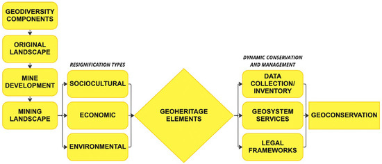
Figure 1.
Flowchart of geoconservation framework for mining landscapes.
Created in 2004, under the heritage umbrella of UNESCO, the Global Geopark Network (GGN) currently comprises 177 UNESCO Global Geoparks (“UGGps”) in 46 different countries, supported by exchange and cooperation actions contributing to the following sustainable development goals (SDGs) of the 2030 Agenda for Sustainable Development: SDG 1 (no poverty), SDG 4 (quality education), SDG 5 (gender equality), SDG 8 (decent work and economic growth), SDG 11 (sustainable cities and communities), SDG 12 (responsible consumption and production), SDG 13 (climate action), and SDG 17 (partnership for goals) [19].
In addition to the network and following the objectives proposed by the 2030 Agenda, a Scandinavian partnership created the GEOfood brand (coordinated by Magma UGGp in Norway), a project that incorporates and certifies the so-called “edible geoproducts”, made from raw materials coming directly from UGGps territories (which is the main criteria for the brand). GEOfood products must follow sustainable practices of production such as: reducing packaging, protecting workers’ rights, safeguarding geoheritage based on local values, and processing and promoting connection with geodiversity [20]. GEOfood intensifies sociocultural values and enhances territorial development by developing narratives for awareness about geological heritage through local and traditional communities, involving them in entrepreneurship, and ensuring sustainability.
As of October 2022, GEOfood is present in 34 UGGps in 21 different countries, working with more than 100 local restaurants, farmers, and schools, ranging from small to medium-sized enterprises [21]. In addition, the brand has also turned into a project team approved in 2021 and awarded by The International Geoscience Programme (IGCP-project 726) Council—a UNESCO hub to facilitate international scientific cooperation in geosciences—which includes 54 partners from 26 countries, comprising researchers from UGGps, universities, institutes, and aspiring geoparks and projects, along with all GEOfood members and partners, which aim to develop the brand and implement it in UGGps all over the world. The project will run for five years, developing tools for the implementation and monitoring of the GEOfood brand worldwide. The results are displayed on the webpage of the project (www.geofood.no; accessed on 1 October 2022), the first project baseline has been developed, and the GEfood board game has been released as well.
Geoparks and GEOfood are expected to play an important role in learning about and experiencing sustainable development [22,23,24]. However, Brazilian initiatives related to the creation of them are still emerging, with only three UGGps officially recognized (i.e., Araripe UGGp, Cânions do Sul UGGp, and Seridó UGGp) and several other projects in development all over the country. The main difficulties in establishing geopark actions in Brazil lie in understanding the geographical concept and values of its territories and the lack of official entities, strategic planning, outreach, and specific legislation related to UGGps [25,26,27]. For GEOfood, two initiatives are currently taking place in Brazil: UGGp Seridó and Canastra Geopark Project;while Araripe UGGp has also expressed interest in joining the initiative soon. In addition, the complications are based on the main criteria that require the establishment of a UGGp for implementation of the brand, along with acknowledgment and acceptance. Today, the establishment of UGGps in Brazil is compromised by the lack of specific planning and geoheritage policies, mainly because geoparks are not included in any Brazilian legislation, which leaves their own implementers to develop them in accordance with the Geopark Program institutionalized by the Brazilian Geological Service (CPMR) [27,28]. The program is dedicated to the identification, description, diagnosis, and wide dissemination of areas with potential for future geoparks in the national territory, as well as the inventory and quantification of geosites. This is not the case for other forms of UNESCO designations in Brazil, such as the Man and Biosphere Reserves (MAB), which have specific directives included in the National System of Protected Areas (SNUC). As discussed by different authors [25,27], this absence can cause confusion and controversies for implementers, communities, stakeholders, and policymakers, which can even be the case for other countries as well [29]. Nevertheless, it corroborates the concepts of UGGps and geodiversity [16,19]—in which the framework previously formulated was grounded—in the sense that the territory is seen as an essential part of the multifaceted and evolving concept, being reformulated, and adapted to local realities and policies around the world. There are two main implementation strategies that have been used as the base for supporting UGGp initiatives in Brazil and in MG; they are in accordance with the demands of UNESCO, facilitate the implementation process, and address the challenges stated before: (i) territorial/administrative borders and (ii) association management (e.g., consortium/multimunicipality management). The first can be summarized by an approach in which the geographical borders of geoparks will follow existing legal limits, for example, municipalities or protected areas. The second comes from UNESCO’s demand for having an agency/legal person responsible for the general management of actions and funds related to all operations. In addition, UNESCO allows for geopark initiatives to come from both the public and private sectors, meaning that, beyond public policies or actions by the state or institutions, companies inserted in these territories can take part in it or even make the first move.
In this article, fundamentally based on the comprehensive framework we developed in the introduction, we discuss and analyze geoconservation in mining landscapes of MG, exploiting the combination of the following approaches: the UGGp label and the GEOfood brand. The state of MG was selected as the study area of this work due its several sites of international geoheritage interest, the currently aspiring UGGps and projects emerging (even though none of them are officially recognized), and the importance the state has as the main representative of mining activity in Brazil. Thus, by a combination of methods, this study aims at: (i) creating a comprehensive catalog to assess and discuss the extent of municipalities’ achievements, (ii) exploring the opportunities, activities, and future initiatives related to geotourism, geoconservation, UGGp label, and the GEOfood brand for the same municipalities, (iii) highlighting knowledge gaps and priorities, as a base for future assessment and application by the communities, providing contribution to different regions, sites, entities, and governments. Additionally, we explore how the framework we created can contribute toward the development of public policies overseeing the sustainable use of mining landscapes throughout the challenges that MG and Brazil need to face, together with the importance of their protection and management, in order to expand the participation of this type of landscape in heritage programs.
2. Methodology
The methodology can be divided into two different parts based on archival research and literature analysis: (i) a combination of an inductive method (i.e., the geoconservation approaches for mining landscapes we introduced in Section 1) with the bibliographic and document analyses presented in this section; (ii) analysis of the existing geosites’ studies contrasted with the identification of mechanisms that contribute to geoconservation. This innovative combination of methodologies provides a timely opportunity to develop a better understanding of the historical, cultural, geological, conservational, and social aspects of mining within the broader context of industrialization, urbanization, and population change in MG. Specifically, we selected 6 areas in MG (Figure 2), which have been categorized based on the following criteria: (i) areas that are currently developing geopark initiatives (aspiring UGGps and projects); (ii) areas that were previously assessed for geopark development by research groups/institutions; (iii) areas that are notable for their remarkable geological features but are not previously included in geopark initiatives. All of them are located in wider areas of mining activity (legally or not). Respectively, four areas have geopark projects under the criteria i (i.e., Canastra (CA), Quadrilátero Ferrífero (QF), Morada Nova de Minas (MN), and Uberaba (UB)), one under the criteria ii (i.e., Coromandel-Vazante (CV)), and one under the last criteria (i.e., Arcos-Pains (AP)) (Table 1).
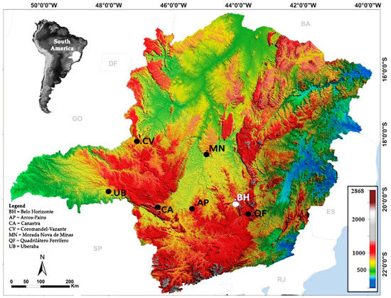
Figure 2.
Topographic map of the Minas Gerais state with its capital (Belo Horizonte) and the 6 selected areas for this study. Site abbreviations: BH = Belo Horizonte, AP = Arcos-Pains, CA = Canastra, CV = Coromandel-Vazante, MN = Morada Nova de Minas, QF = Quadrilátero Ferrífero, and UB = Uberaba. Note: the surrounding translucent abbreviations (i.e., SP, RJ, ES, BA, DF, and GO) correspond to neighboring states and districts.

Table 1.
Overview of selected areas in the state of Minas Gerais and their categorization based on the study’s criteria.
2.1. Literature Analysis
Based on the application of our framework and the check of UGGp creation stages at each area, we identified geosites and possible resources/opportunities for enhanced geoconservation in MG and discussed the creation of new geopark projects. Assessing and quantifying the elements of geodiversity is not a simple task, and the methodologies used for this purpose can involve the evaluation of geological contents based on quantitative and qualitative approaches [30,31,32], the elaboration of maps and their comparative analysis [33,34], and the study of scientific literature and technical reports to assess the state of the art and identify knowledge gaps [32,35,36,37]. Therefore, our extensive analysis considered official information sources provided by each part (i.e., dossiers, evaluation reports, application files, websites), available peer-reviewed papers, and interviews (i.e., phone calls and oral conversations with managers and stakeholders). First, we describe each selected area and the characteristics and state of the geosites (i.e., regional historical geotourism development, extension, and landscape diversity), and the development of these programs along with the institutions, companies, and government bodies involved. Secondly, we carried out a critical analysis on policies, legislation, and organizational guidelines related to UGGp and GEOfood proposals and offers in Brazil, evaluating their development and implementation in accordance with national and global trends. Finally, we cataloged and reported administrative actions, knowledge advancements and gaps, and the engagement of geodiversity and geoconservation concepts within mining landscapes.
2.2. Geosites Analysis
For the inventory and analysis of geosites, we collected data for each area in accordance with their official presentation documents/websites. If not available, data were collected from peer-reviewed papers and information materials. The classification consisted first of the interpretation of potential interests for each geosite; after that, data were contrasted with information available on the GEOSSIT’s platform by the Brazilian Geological Society (CPRM). GEOSSIT is a Brazilian public platform (http://www.cprm.gov.br/geossit/; accessed on 16 October 2022) and an extensive database for registering geological sites and materials (in situ and ex situ) in Brazil [25,37,38,39,40]. The inventory, under collaborative progressive construction, includes the quantification of the geoscientific interest taking into account the representativeness, uniqueness, rarity, expression, and integrity of the geological aspects of these places and elements, in addition to the clarity in portraying relevant themes, facts, processes, phenomena, or geological events. The quantification is represented by tabs that correspond to the characterization of the following attributes: aesthetic (AE), educational (ED), scientific (SC), economic (EC), cultural (CL), touristic (TO), religious (RE), and historical (HI), along with the risk of degradation, the classification of the sites according to their relevance, and their specific recommendation for protection and conservation. Obtaining the classification and values related to each site is carried out by assigning weights to predefined parameters, generating a number that is automatically calculated by the platform. Carrying out geoheritage inventories in a region or country is a complex activity, mainly involving consultation with experts through lists of previously established criteria [40,41,42,43].
We classified all information in a table based on what was found in the platform according to their interest and status: “in analysis”, when the geosite was already submitted for evaluation; “consisted”, when the geosite was already approved; finally, “N/A’’, when there was no information regarding the selected geosite. Finally, we highlighted the ones presented in both the in-depth literature analysis and GEOSSIT’s platform. The main purpose is to recognize and identify the different Brazilian geological values in their different natures and locations.
3. Description of Case Studies in the State of Minas Gerais
Among the five largest states in Brazil, Minas Gerais is in the southeastern region of the country with an area of 586,528 square kilometers, with Archean to Phanerozoic age sequences occurring in the most varied tectonic and metamorphic context. An eroded plateau comprises most of the region, with several mountain chains surrounding the state, including peaks that can reach approximately 2800 m a.s.l., which differs from other regions of the country due to the diversity of the morphological conditions present [44] (see Supplementary Material S1 for a complete geodiversity map of the state).
Mainly composed of cerrado (Brazilian savanna) and Atlantic Forest, the region also presents other tropical biomes such as broadleaf rainforest, desert shrub, rupestrian fields (caatinga), and Atlantic Forest, holding a high diversity of fauna and flora [44,45]. Despite being the second largest biome in South America, only 8% of the whole cerrado is considered protected areas, with 3% at the highest level of protection [46]. The state numbers are even worse. The total area under full protection corresponds to 1.96% of the state’s territorial extension, still far from the 10% that is the state’s goal [45]. At the same time, a great part of the outstanding biodiversity and geodiversity of the state is seriously threatened by human actions [46]. Approximately half of the cerrado is converted into agricultural or fragmented land, while the Atlantic Forest is the most vulnerable biome in the state, with the lowest proportion of remaining vegetation (23%) and the lowest percentage of areas under full protection (1.1%) [44,45,46]. In addition, the impressive geomorphological landscapes, hydrological resources, and speleological and archeological sites are home to many hydroelectric and mining activities, ranging from small to large-sized operations [31,46]. Nowadays, the MG state has an intense predatory exploitation of natural and mineral resources, with numerous animals and plants at risk of extinction; it is estimated that 20% of the native and endemic species in the region no longer exist in protected areas [46,47].
3.1. Arcos-Pains Karst Region
The Arcos-Pains karst region is in midwestern MG; due to its carbonate bedrock, it presents a karst landscape of relevant geographic interest since the 19th century, both scientifically and economically, given its importance in the karst/speleological scenario [48] (Figure 3). Comprising the municipalities of Pains, Arcos, Doresópolis, Iguatama, Córrego Fundo, and Formiga, it is characterized by the constant presence of rugged reliefs associated with limestones and smooth and wavy shapes from claystone [48]. Pains is known as the world’s capital of limestone. The landscape is also known for its outstanding aesthetic values, mostly composed of canyons, caves, and water resources, and is included even in Brazilian films (e.g., Faroeste, directed by Abelardo de Carvalho).
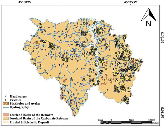
Figure 3.
Geological and hydrological map of Pains, Minas Gerais State (modified from [50]).
There are several studies on the area, especially related to the geological, speleological, and biological aspects. The region is famous for its unique speleothems, archeological sites with stromatolites, cave paintings, and artifacts that date back to the history of the primitive peoples who lived there. Beyond the usual species that are found in the cerrado landscape, the fauna and flora have their habitat and ecological niche intrinsically related to natural caves. The most impressive finding is an endemic species of anura (Ischnocnema karst), which is included as an endangered species in Brazil [49].
Altogether, it is an area subject to intense mining operations and deposits, both legal and illegal. Pollution and degradation are often exacerbated. On top of that, illegal fishing practices, deforestation, and water abstraction pose environmental threats and challenges to the region’s ecosystem.
3.2. Canastra Geopark Project (CG)
In midwestern MG is the Serra da Canastra National Park, designated in 1972 by the Chico Mendes Institute for Biodiversity Conservation (ICMBio), with an area of 200,000 hectares, of which approximately 85,000 hectares are protected [45]. It preserves the sources of the São Francisco River, which is approximately 3000 km long, the fourth largest river in South America, with several other exceptional geological and geomorphological features covering the territories of six municipalities: São Roque de Minas, Capitólio, Vargem Bonita, São João Batista do Glória, Delfinópolis, and Sacramento. The initial proposal of developing the Canastra UGGp revolves around previous assessments and work conducted in the region proposed by the Brazilian Geological Survey [26,51,52] and established with the help of upcoming interest from scientists, professors, stakeholders, and communities of the region, especially the Instituto Federal de Minas Gerais—IFMG Bambuí (officially engaged with the park in several research and educational activities), a partnership with the University of Turin (in Italy), and the IGCP 726 (despite the GEOfood brand being exclusive to UGGp sites, the project is already introducing its concept, events, and assessments).
The landscape is characterized by the presence of a rich biodiversity and outstanding aesthetic values, such as many native species and the vegetation mainly based in cerrado, patches of the Atlantic Forest, and rupestrian fields [45,47]. Not only does the region draw attention for its biodiversity, but its geodiversity and geoheritage provide an unusual variety of international geological significant elements, such as hydrographic features (many springs, waterfalls, rivers, and streams), archeological, and monumental sites, such as the Casca d’Anta waterfall, which is approximately 186 m high and one of the park’s main attractions, and the Chapadão da Canastra (or Diamante), which is a set of mountains and plateaus resulting from geological processes and phenomena that date back to the Proterozoic, ranging from 900 to 1500 m in height (Figure 4) [47].
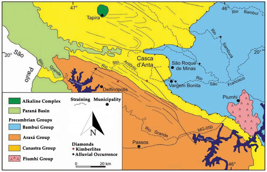
Figure 4.
Geological map of the Canastra region in Minas Gerais State (modified from [51]).
Nowadays, under the federal administration of the ICMBio, the region is subject to many controversial management actions—intensified by the current federal government—causing several landowner conflicts and no investment in public policies for the locals whatsoever. The region also faces problems such as the consequences of years of deforestation, wildfires, erosion, intensive mining operations, livestock production, and sugarcane agriculture.
3.3. Coromandel-Vazante Region
Coromandel and Vazante are two municipalities located in the Triângulo Mineiro region in western Minas Gerais, based on the Bambuí speleological province, a complex karst system that encompasses several features, including endokarst (caves) and exokarst (sinks, sinkholes, and karst springs) (Figure 5) [53]. The region was named after its triangle-shaped territory and is one of the most important in terms of economy for the state. Historically, the exploitation and settlement of the area was mostly done by the slaving and extermination of indigenous populations and maroon communities (quilombolas) as it was in the entire Brazilian colony [53,54]. Additionally, the area is known for its impressive geological features, such as waterfalls, lakes, mountains, and caves, along with geotourism activities related to leisure and contemplation of those features. At the same time, mining is one of the main economic activities developed in the area, followed by agriculture-related industries and business [54].
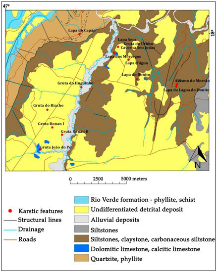
Figure 5.
Geological and hydrological map of the Coromandel region in the Minas Gerais State (modified from [55]).
Coromandel has an approximate area of 3313 square kilometers and an estimated population of 28,398 inhabitants. In 1997, the municipality was certified by the Brazilian Institute of Tourism (EMBRATUR) due to its ecotourism potential and included in the tourist route of the Triângulo Mineiro region [54].
Meanwhile, according to the Brazilian Institute of Geography and Statistics (IBGE), Vazante has an approximate area of 1913 square kilometers and an estimated population of 20,506 inhabitants. The municipality is known for its various different-sized underground chambers, where cultural and religious festivities are held.
3.4. Quadrilátero Ferrífero Geopark Project (QF)
The Quadrilátero Ferrífero (or the Iron Quadrangle), is a ferruginous geosystem in the central-southeastern part of the Minas Gerais state with approximately 7000 square kilometers, composed of tonalitic-granitic gneisses of Archean age (Figure 6) [56,57]. The area has fundamental importance for the state’s economic development, and it is composed of the following municipalities: Alvinópolis, Barão de Cocais, Belo Horizonte, Belo Vale, Bom Jesus do Amparo, Brumadinho, Caeté, Catas Altas, Congonhas, Conselheiro Lafaiete, Ibirité, Itabirito, Jeceaba, Mariana, Mário Campos, Moeda, Nova Lima, Ouro Branco, Ouro Preto, and Raposos.
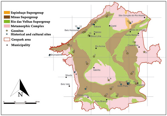
Figure 6.
Geological map of the Quadrilátero Ferrífero Geopark project area (modified from [56,57,59]).
Recently, the area was one of the four Brazilian sites included in the The First 100 Geoheritage Sites by the International Commission on Geoheritage (IUGS) as one of the most important records of the Paleoproterozoic banded iron formation on earth [58]. The capstone deposits (in Portuguese “cangas”) are formations that originated due to the concentration of ferruginous compounds welding different materials because of the intense action of climatic factors on the geological material [56,57]. The region has been a landmark for European and African populations in the region since the 17th century. These deposits have been the subject of geochemical and tectonic investigations and studies on the genesis of duricrusts and related cave formations [57,58,59].
Well known for its mineral richness, as well as gold and ore deposits that historically led to the creation and development of several important mining towns and roads, such as the Rota do Ouro (Gold Route), Ouro Preto, and Mariana [55,56], the Gold Route is full of trails, waterfalls, valleys, caves, and historic buildings that range from mansions to churches built during the Brazilian Gold Cycle (18th century) [59]. The municipalities in the area are all connected by the Estrada Real (Royal Road), whose more than 1600 km in length make it the largest tourist route in Brazil passing through three states: Minas Gerais, Rio de Janeiro, and São Paulo.
The region has the highest urban concentration in the state, and the intense exploitation of these resources by the industrial sector without proper environmental monitoring has triggered a series of impacts [56]. In addition to the large iron and gold mines, the region also has several mining businesses that exploit deposits of several rocks and minerals (e.g., topaz and bauxite) [55]. Among the problems detected are groundwater and soil pollution, loss of biodiversity, improper disposal of hazardous waste, and erosion [56,59].
3.5. Morada Nova de Minas Geopark Project (MN)
The Morada Nova de Minas geopark project is located in the central region of MG, belonging to the Três Marias micro-region (Figure 7). With an area of 1735 square kilometers, the project is coordinated by Gasbras-MG, the Federal University of Minas Gerais, the Nuclear Technology Development Center, the International Institute of Ecology and Environmental Management Association of São Paulo, the Federal University of Ouro Preto, and the National University of Comahue (in Argentina) [60]. The group has been working with geopark actions in the area since 2017. It encompasses three municipalities: Morada Nova de Minas (the main center with 8910 inhabitants), Biquinhas (with 2498 inhabitants), and São Gonçalo do Abaeté (with 8459 inhabitants) [60].
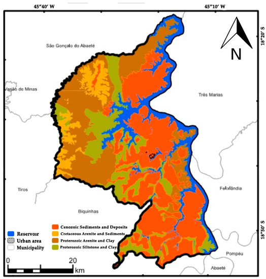
Figure 7.
Geological map of Morada Nova de Minas in the Minas Gerais State (modified from [60]).
Situated in the São Francisco basin, one of the largest terrestrial sedimentary provinces in Brazil, MN holds large reserves of natural gasses deposited thousands of kilometers deep that can be commonly observed in the surrounding rural areas, where they emanate from the ground or waters and can naturally catch fire [60]. The gas in the area is a fossil fuel generated from the maturation of organic matter deposited over millions of years of geological events. In the São Francisco basin, the gas is estimated to have formed between 740 and 550 million years ago in a marine environment of sedimentation [60]. It is known as unconventional (or shale gas), as it is deposited in very deep and little porous rocks, which are difficult to access. In 2011, MG’s government announced the existence of a volume between 176.6 billion and 194.6 billion cubic meters of natural gas, which would guarantee a production capacity of 25 years [60].
During the 1960s, the Três Marias hydroelectric plant was built in the region and flooded part of its land, harming the farmers and locals and consequently the economy, population growth, and natural resources [61]. At the same time, the reservoir, along with the lakes and rivers of the region, brought a new economic aspect to the area based on fish farming and touristic and cultural attractions because of its aesthetic values and hospitable people. Today, agriculture, aquaculture, livestock, and forestry are strong practices as well.
3.6. Uberaba—Terra de Gigantes Geopark Project (UB)
Situated in the same region as Coromandel and Vazante in western MG, the area of the Uberaba Terra de Gigantes (Land of Giants in English) encompasses the municipality of Uberaba and is approximately 454,051 square kilometers with 340,277 inhabitants, according to the IBGE in 2020 (Figure 8). The project is a partnership between the Uberaba City Hall, the Brazilian Association of Zebu Cattle, the Federal University of Triângulo Mineiro (UFTM), and the Brazilian Support Service to Micro and Small Companies (SEBRAE).
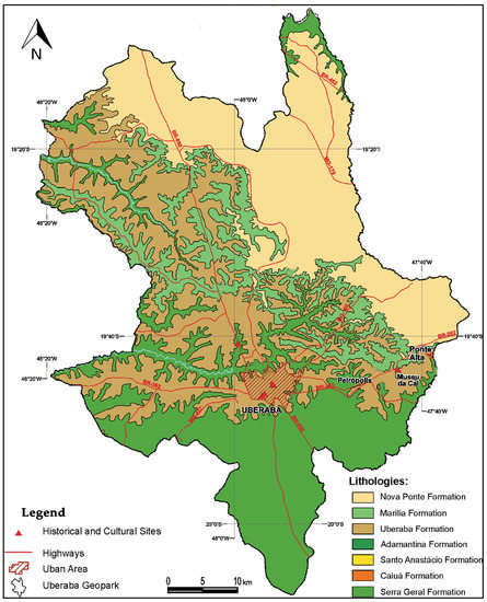
Figure 8.
Geological map of the Uberaba territory (modified from [62]).
Situated in the Bauru basin, which constitutes effusive rocks with an alkaline character [63], the topography of the area is primarily smooth, composed of monotonous undulations, broad hills, dominated by watercourses with an area greater than 4 square kilometers, extensive and flat tops, slopes, and unique geological units [62,63].
In the late 19th and throughout the 20th century, the growth of many activities related to mining, agriculture, livestock, and industries, with the participation of European immigrants, made the municipality a solid and diversified industrial park and a dynamic and productive commercial center, being included in the Royal Road of the state [64]. In the 1940s, workers discovered traces of fossils, unfolding a series of intense paleontological investigations that started due to mining and industrial operations that found the first evidence. The reason is that the entire municipality comprises one of the largest and most important paleontological sites of the Brazilian continental Cretaceous—with fossil records dating from 80 to 65 million years old—and is home to the Titanosaurus (Uberabatiban riberoi), the largest known dinosaur in Brazil [62].
In addition to the remarkable geosites scattered throughout the city, historical, artistic, and sociocultural landmarks are also significant, such as the several paleoarts created by Rodolfo Nogueira. Moreover, the zebu cattle have important economic and cultural values to the region due to its world-famous festivals, fairs, and technological advances. Moreover, the strength and significance of the municipality’s religious values are mostly based on the philanthropist and spiritist Chico Xavier, known as the greatest spiritist leader in Brazil’s history, attracting approximately 250 thousand visitors throughout the year [62,64].
4. Results and Discussion
4.1. Geopark and GEOfood Implementation and Management Analysis
Some of the cases included in this work have areas or are already under the SNUC as protected areas, for example, CA, QF, and MN, which have different areas designated as conservation units (i.e., national and state parks). It is important to highlight that being included under the SNUC is not mandatory for the implementation of geopark areas, but it can help in determining a well-defined territorial extent and designing an action plan for conservation and management for UGGp application since most of the SNUC areas have defined a management plan, some infrastructure, and necessary equipment [65]. Nonetheless, UNESCO requires that the overlap of different protected areas must be clearly justified, showing evidence of increased values. Integrated management based on different heritage efforts can be successful global conservation instruments, provided that there are human and financial resources to sustain the actions and strategies over time and that they are supported by public policies [65,66,67].
Moreover, local communities are an essential component of a geopark. Their support and involvement are mandatory for the implementation and development of the geopark initiative. The geopark projects or suggestions discussed here can only move forward with their actions along with their respective communities’ participation. Giving locals the responsibility of applicants and managers is a fundamental cooperation instrument for the development of actions at the local level, promoting the exchange of information, additional partnerships, voluntary rules, and experiences that contribute to building capacities related to sustainable planning and the strengthening of decision-making approaches [68,69,70]. All three recognized Brazilian UGGps have created their own respective multimunicipality consortiums/associations, established through partnerships and cooperation between different bodies, entities, and communities (each project in MG is discussed in detail in the subsections below), with the aim of sharing knowledge, ideas, and practices to reach the full potential of geopark actions as well as the development of local communities.
Finally, most of the mining landscapes in this study are in rural areas, presenting several new possibilities for linking mining and rural development, whether economic, social, or environmental. Assessing the values related to the mining landscape for communities can provide essential information to raise awareness of the importance of geoheritage and the management of these areas, particularly if the area in question presents some essential value for the communities [30,31]. Despite the reluctance of companies in Brazil to recognize geopark-related initiatives as a strategic ally to demonstrate the importance and necessity of mining activities for rural communities, the idea is not new; successful examples can be drawn from globally recognized geoparks in both Europe and Asia, bringing benefits to all sectors involved and, especially, future generations [71,72,73]. Additionally, once an UGGp and GEOfood, enterprises and producers inserted in the territories can make use of them as a “status”, creating new frontiers for marketing and promotional tools. Branding is an essential component of the implementation stage; it represents the image of the program, how the public recognizes and identifies themselves as actors, and the actions related to geoparks. For locals and tourists, the strength of a brand can further assist in attracting new visitors, engaging emotions, evoking personal beliefs, and prompting ecological and geological friendly stewardship when the brand’s core values are appropriately expressed [22,74].
4.1.1. Quadrilátero Ferrífero
From the analyzed cases (Table 2), the project QF is the biggest one, comprising a bold number of 28 municipalities. The project started in 2011 with the partnership of the Public Consortium for the Development of Alto Paraopeba (CODAP), and it was expanded in 2014 with the Strategic Economic Development Council (CEDECAP) and the Quadrilátero Institute, originating an effective cooperation network supporting and promoting programmatic, organizational, and statutory conditions related to sustainable practices. Since January 2018, the project is also a member of the Sustainable Development Solutions Network (SDSN) enhancing actions and partnerships with UNO towards Agenda 2030 and the Sala Verde from the Brazilian Ministry of Environment, encouraging educational spaces to act as training and environmental information centers.

Table 2.
Status of the selected case studies regarding their administrative actions.
The project has an official logo, and they supplemented their actions by creating a dossier to officially become an aspiring UGGp in 2011, but it was not completely successful [75,76]. During one of our interviews, the managers explained that during the initial phase, some mining companies inserted in the territory presented resistance against the geopark idea. However, the initiative is positive about integrating them again due to the fact that a lot has changed since the start of the project in the last decade, meaning that new national mining policies and political scenarios require new and urgent actions/demands from the sector. The project is starting a new phase in 2023, focusing on rescuing processes left behind and investing in new approaches such as delimiting a new area of influence for the geopark, highlighting the necessity of involving locals (communities and the private sector), investing in short- to long-term social, educational and geoconservation actions enabling greater management viability, and better preparation/integration in order for all of them combined to make profits from the socioeconomic benefits based on this big project. The managers stated that the new phase, along with the upcoming new federal government, shows a possible path and solution for the problems found in an extremely large geopark area.
Its official website is the most complete one, with plenty of information regarding the project, their activities, partnerships, official logo (Figure 9), and their last UNESCO dossier submitted; however, its last update is from early 2022. Websites and social media are considered highly effective educational tools, used worldwide (i.e., rural and urban areas) for indoor and outdoor activities, and the case of geoeducation is no different [77,78].

Figure 9.
Official logos of the projects in the state of Minas Gerais. It is possible to find in each logo unique characteristics representative of its geoparks, such as: flowers (Actinocephalus polyanthus) and the iron banded formation from Quadrilátero Ferrífero; different species from freshwater to land ecosystems (i.e., Oreochromis sp. and Ara ararauna) from Morada Nova de Minas; fossils, cattle, and Chico Xavier from Uberaba—Terra de Gigantes.
Moreover, the IGCP 726 is in contact with them for a possible future addition to the list of members by implementing GEOfood’s initiatives in the region. One major strategy is the involvement of the famous craftsmen and enterprises working with ornamental stones. The aesthetic values associated with the stones are present in many aspects of the Quadrilátero Ferrífero, such as churches, museums, mansions, souvenirs, and heritage sites [79]. They can be used in different UGGp and heritage initiatives, such as the experiences shared by Sesia Val Grande UGGp with heritage stones [80,81]. Furthermore, the addition of the area to the First 100 IUGS Geoheritage Sites, combined with the already famous trails and routes established, could be promoted through GEOfood Food Trails, boosting interest in the geological peculiarity of the area, and attracting thousands of tourists. Several GEOfood partners (e.g., Burren and Cliffs of Moher UGGp; Cliffs of Fundy UGGp) have established food trail networks crossing their territories, connecting geotourism, local enterprises, and outdoor activities [82,83].
4.1.2. Canastra
The project was recently introduced to UNESCO (in 2020) at the “1st International Digital Course on UGGp: territories of resilience”, and it is in the process of creating its dossier for submission, along with an official website and logo.
Beyond the six main municipalities that are part of the CA region and have some level of consortium created—meaning that they have included multimunicipality management and actions with more diplomatic settings based on previous agreements of the Serra da Canastra National Park—the new project also has a strong motivation for the inclusion of the municipalities part of the Canastra terroir, as they present the same characteristics as the others included and new geosites that are being assessed by local institutions. The mountainous region is well known worldwide for its terroir, in which climate, native pastures, and the artisanal process confer unique characteristics to the locals’ products, which are derived from traditional agriculture and livestock activities [84,85]. The terroir encompasses the municipalities of Bambuí, Medeiros, Piumhi, and Tapiraí, as well as totaling 10 municipalities and requiring new forms of association.
Furthermore, future GEOfood initiatives mainly revolve around livestock and dairy products, especially in the Canastra cheese, with the partnership of the Association of Canastra Cheese Producers (APROCAN). The association created its own label to recognize, certify, and control the cheese origin. Meanwhile, the product is safeguarded as a Brazilian intangible cultural heritage under the National Historical and Artistic Heritage Institute (IPHAN) [84]. It is important to highlight that even if a product is already part of a label or protected by public policies, it can also be included as GEOfood if it is in accordance with the criteria and the values expressed in the brand’s manifesto. In addition, many other foods and general products made in the region through artisanal processes and traditional communities (e.g., cachaça, dulce de leche, tapioca flour, and jam) can be included as GEOfood as well since the raw materials are derived from the geopark area. French and Portuguese UGGps have developed successful examples with similar products [86,87]. By now, it is the only project in MG that is a member of the IGCP 726 project, developing actions towards awareness, networking, assessments, and strategies for GEOfood development in partnership with the Federal Institute of Minas Gerais—Campus Bambuí.
4.1.3. Uberaba—Terra de Gigantes
In regard to the project UB, since it is composed of one municipality only, the responsibility falls under the City Hall administration and the institutions listed in the description of the site, based on an institutional nonprofit association model. Currently, it is the most advanced geopark project in the state in terms of implementation. They have a strong presence on social media (i.e., Instagram and Facebook) and plenty of information spread across different tourist and media sites in Uberaba. According to the managers, the official website should be out in the upcoming weeks, and the application and letter of intention were submitted to the Brazilian Ministry of External Affairs in November 2022 [88], which has the responsibility to handle them for the UNESCO committee to become an aspiring geopark. The results should be out by 2023.
The focus of the activities is surrounding the creation of local policies to protect geoheritage and strengthen geoconservation. The municipality is carrying out paleontological mapping to identify areas where it is easier to find fossils. In this way, future enterprises will know where to develop their initiatives without compromising geoheritage elements. Furthermore, there is a deployed quarry (a geosite open to visitors) and an active quarry located in the geopark territory that is not open to visitors now, although the geopark administration is working to open it soon.
In terms of geoproducts, the project has been investing in a vast catalog, including several actions focused on local symbols (i.e., dinosaurs, fossils, Chico Xavier, zebu cattle), as well as crafts made with sustainable materials. More than 1000 different items are included, mainly Christmas items but also crochet items, accessories, biscuits, MDF crafts, wooden and rock art, cloth dolls, rugs, etc. They are curated by the administration and sold in different stores under the geopark label across the area. In addition, the GEOfood network is in contact with them about a possible future addition to the list of members as well. One big strategy for GEOfood in the location is that the geopark’s symbols (i.e., paleontological and spiritual values) can be used as authentic and unique ways to explore storytelling and intangible heritage, supporting local communities’ engagement in the valorization of traditions and commitment to sustainable development.
4.1.4. Morada Nova de Minas
According to the managers, the project was developed as a compensatory measure for the company Gasbras-MG, which intends to make use of the natural gas present in the region. Many of the elements required for an aspiring geopark application were suggested and initially developed in the dossier; however, it needs to focus on regional and local development, involving education, heritage conservation, improvements in the tourism sector, and initiatives that encourage community empowerment and local government actions. Despite the good development in terms of partners and surveys, no association was created between the municipalities involved. Knowing that hydroelectric activity and the future installation of a natural gas industry can cause impacts of various types, the Gasbras-MG project can be one of the most interesting geological features supporting this UGGp project. Beyond their commitment to protect the region from the negative effects of gas extraction, their processes can be the basis for some of the geotourism resources and economic activities that can be major components when integrated into the project. Projects in Europe and Africa are making use of gas, reservoirs, and hydroelectric power to support their implementation and activities [89,90,91].
From a GEOfood perspective, sugarcane and fish production should be considered the main assets. The region is known for being an important pole in the Brazilian fish market, and the geopark is expected to partner with COOPEIXE (a local fishers association) to strengthen initiatives related to public policies licensing their processes. Many local producers are unaware of their cost structure and how to become more efficient. In addition, there is a shortage of adequate labor, inputs and technologies are expensive, and there are no credit lines available for aquaculture farmers [60]. As part of the GEOfood network, the area could rely on their knowledge sharing for the promotion and structure of capacity building and the logistical chain, based on local markets, profitability, and sustainable practices. As a result, under the brand label, their products could become even stronger and more competitive in the market, and they could even ignite or support discussions on public policies for fishers. Increasing the fish productivity can contribute to value-derived products as well (e.g, meat processing and the reuse of tilapia skin in the textile and medicinal markets), and some examples can be drawn from different enterprises in UGGps such as the ones in Magma, Qeshm Island, and Burren and Cliffs of Moher [92,93]. Nevertheless, GEOfood is currently in contact with managers, trying to establish partnerships.
4.1.5. Arcos-Pains and Coromandel-Vazante
Despite having several national and international studies in different areas such as geodiversity, geology, geoheritage, and geoconservation, administrators in both AP and CV have not yet proven any interest in geopark development. However, Oliveira [94] comprehensively conceptualizes the geomorphological heritage potential of the two municipalities involved in the CV region, while Timo [95,96] does the same for AP. Based on their reports and our analysis, we proposed, in Section 3, viable municipalities that could be included in case of association. Currently, the knowledge and actions taking place in those regions can tremendously benefit from UGGp, as studies have shown in similar areas [43,97]. If combined with prominent help from the local administration, the private sector, or institutions—including support from renowned research centers (but not limited to); for CV: Federal University of Uberlândia—UFU and Federal University of Minas Gerais—UFMG; for AP: Federal Institute of Minas Gerais—Arcos, Bambuí and Formiga—can foster geoparks’ initiatives and strengthen the existing system of self-regulatory instruments for geoconservation in the region.
The presence of many mining operations in the AP region and the Mining Association of Pains-Arcos (AMPAR) can be seen as important assets if well explored. Together, they can promote pioneering joint actions for the mining workers and companies, as well as seek support from local and state governments and other segments of organized civil society for regional development based on geopark strategies, respecting the environment/mineral resources, and advocating for social justice and sustainability.
Surely researchers and other big players we have discussed can ignite conversations and propose options, but locals and stakeholders should always participate as well. The need for information/clarity about geodiversity values and the public entities and mechanisms involved, along with low heritage education, can present obstacles for the communities’ members of the projects analyzed. In this case, policies, investment, and motivation for geopark implementations are low, and the same is true for budgets/funds and activities. Understanding and elevating the UGGp and GEOfood concept, keeping in mind the balance between protected areas-land-use, is a big step for sustainable development in MG, primarily including different sectors such as private and public.
4.2. Geosites and Geoheritage Aspects
All geosites were analyzed and classified according to the aforementioned criteria (Section 2). Among the contrasted data (Table 3), the UB stands out, with 12 of its geosites present in the national registry. In our interviews, one of the managers mentioned the intensive work of the prominent scientist Luiz Carlos Borges Ribeiro in assessing and maintaining the local sites over the last few years. In addition, QF has six of its geosites present in the national registry and four in analysis, followed by CA with four present and one in analysis (geosite examples can be found in Figure 10, Figure 11, Figure 12, Figure 13 and Figure 14). Despite having some good initiatives being led by a few institutions and state agencies, such as geosites assessed in previous works, monitoring and practicing geoconservation, AP, CV, and MN did not have any geosites included in the national registry of GEOSSIT. This is probably due to the following factors: lack of knowledge about the national platform, the UGGp label and GEOfood brand, human resources, or special funds. Mostly, they are focused on measures to address major issues, such as irregular activities in the extraction and processing of minerals, environmental crimes, and vandalism in geosites. Successful geoconservation efforts require access to funds, manpower, capacitated personnel, monitoring, assessments, partnerships, and interdisciplinary approaches [98]. Additionally, investments in public educational policies strengthen the teaching of geosciences from elementary school to higher education, encourage environmental education practices, while fostering the training of stakeholders and guides, the creation of protected areas, and promote appreciation of geotourism [99].

Table 3.
Geosites and their respective interests in each site. Interest abbreviations: aesthetic (AE), educational (ED), scientific (SC), economic (EC), cultural (CL), touristic (TO), religious (RE), and historical (HI).
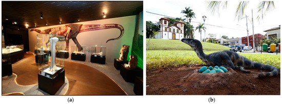
Figure 10.
Geosites located in Uberaba: (a) Dinosaur’s Museum and (b) Saint Rita (Source: UFTM/Uberaba City Hall).
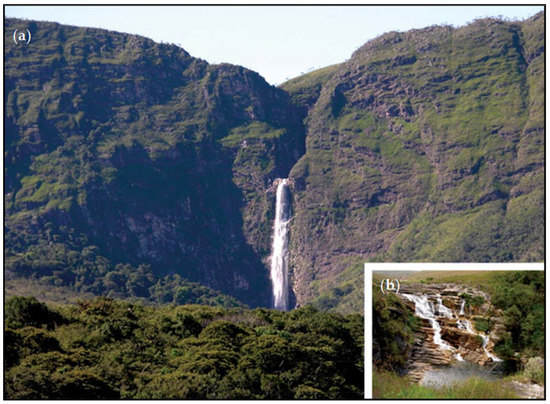
Figure 11.
Geosites in the southern slope of the Canastra Range: (a) Casca d’Anta Waterfall (Source: A. C. Girodo) and (b) view of the upper part of the waterfall (Source: L. Benitez).
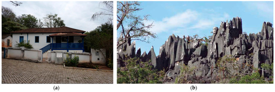
Figure 12.
Geosites from the Arcos-Pains region: (a) Karst Archeological Museum (Source: M. B. Timo) and (b) carbonate wall with its spitzkarren (Source: L. E. P. Travassos).
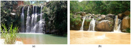
Figure 13.
Geosites from the Coromandel-Vazante region: (a) Mascate waterfall and (b) Barreiro waterfall with its muddy waters after raining (Source: P. C. A. de Oliveira).
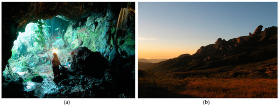
Figure 14.
Geosites from the Quadrilátero Ferrífero: (a) Piedade cave (Source: L. E. Faria) and (b) Itacolomi mountain peak (Source: L. G. Godoy).
One incoherence found in the analysis was that multiple geosites were included in the platform as only one, which can be explained by bundle characteristics in certain geosites (e.g., geographically adjacent geosites can collectively tell a story) or by different people adding information on the online platform [100]. Moreover, it is also important to state that some regions (i.e, QF) had geosites included in the platform that were not in their official reports. For QF, some studies include inventories of 55 sites of natural and cultural interest, representative of the geological and mining history in that territory, even though they did not make it to the final dossier.
Furthermore, the karst geosystems home of the geosites in AP and CV present outstanding examples with caves and grottos, with several archaeological and historical records and sites representing the long history of mining and quarrying in the region. Those features have been used in different UGGps with significant results for geopark-based geotourism, where visitors can discover and learn about the mining grounds and their activities, geological heritage, historical landscape aspects, and the identity of the area [101,102]. For MN, beyond the analyzed geosites, the presence of natural gasses can present new opportunities for geosite development [103].
In general, sites must increase their staff in the field to be able to cover the whole area for their monitoring activities. Beyond that, the staff must be properly trained to be able to conduct evaluations of different resources and even economic activities. In addition, as there are regions where there is a high concentration of attractions and geological diversity, access to geotourism activities should not be allowed only to contemplate different aspects of geomorphology but should favor and promote the awareness and importance of the local resources. The existence of guides, panels, educational programs, and preventive activities can arouse interest by emphasizing the sustainability and legality of the use of resources related to mineral production due to the maximized demand for the high productive potential of the municipalities.
However, for the establishment of a UGGp, additional actions are necessary, as only the presence of important geological sites is not enough. Regarding geotourism, many of the municipalities have remarkable attractions, infrastructure (e.g., hotels, restaurants, etc.), and tourist demand (whether during local festivals or randomly). Nevertheless, adequate planning is also needed if recreational and educational activities want to be developed in a sustainable way and become viable both for those who make use of them and for the ones that manage them [104]. According to the different managers contacted, there are some further actions that are being developed to subsidize the consolidation of geotourism in the areas: interpretive signalization and panels, developing of a geotourism plan and map, assessment of geosites, training, more effective community participation, and the inclusion of geoeducational programs in local schools.
It is understood that the strategies promoting geoheritage are important tools for understanding and disseminating the concept of geodiversity, however, they need to be improved so that their objectives are widely achieved. It is not mandatory to protect all areas, as society needs to make use of resources for its subsistence. However, it is necessary to inventory and protect the most relevant elements. Limiting access to some geosites can also become an important strategy. For example, for geosites with an expressive amount of eccentric and fragile speleothems or species such as the ones in AP, overcrowding can damage, breaking or even trampling them. In this case, it is suggested that the visitation is carried out only by coordinated small groups.
5. Conclusions
Regardless of the absence of specific legislation and relatively new initiatives in geoconservation, Brazil is brilliantly tracing its way as a reference for the world of geodiversity. Considering the characterization and consolidation of UGGp and GEOfood initiatives and how they promote adaptive management, providing achievements in geoconservation and sustainable development, it is correct to affirm that the initiatives linked to the creation of geoparks in the state of Minas Gerais have shown an expressive expansion in the last decade. This fact can be understood by the number of existing publications and projects analyzed here. In this way, the initiatives discussed must be sought as a real possibility for sustainable management practices in mining landscapes and for the maintenance of these municipalities even after the end of the mining activity. In addition, the managers we contacted have shown interest in developing cooperative actions/strategies and partnerships with different projects in the state. With several state projects working together and supporting each other, that could potentially lead to the creation of a solid network of UGGps for MG.
In general, countries or regions whose economies are subordinated to mining activities face challenges imposed by market dynamics, risks and scarcity related to natural and mineral resources in the medium- to long-term (with the need to develop sustainable activities that replace the post-mining era), and greater responsibility to the environment and local communities. Minas Gerais will be no different. Ultimately, the expansion of the UGGp label and geoconservation could secure financial resources at a global and national level to carry out projects, programs, and adapt infrastructure. Thus, the catalog, assessment, and discussion in this study about the potentials of the areas indicate a path for the next actions, which include: political support and financial resources for the development and execution of an action plan/geoconservation plan and more educational actions, as well as the identification and maintenance of geosites and geoheritage. The expansion of protected areas and geoconservation initiatives, such as the ones we have shown, should be considered priorities if we want to guarantee the preservation of remarkable world resources.
Supplementary Materials
The following supporting information can be downloaded at: https://www.mdpi.com/article/10.3390/resources12020020/s1, The complete geodiversity map of the State of Minas Gerais developed by the Brazilian Geological Survey is available as supplementary material S1.
Author Contributions
R.O.P. contributed to conceptualization, methodology, validation, formal analysis, investigation, writing (original draft preparation, review and editing), visualization, supervision, project administration, and funding acquisition; S.G. contributed to conceptualization, validation, and writing (review and editing); M.G. contributed to conceptualization, validation, writing (original draft preparation, review and editing), supervision, project administration, and funding acquisition. All authors have read and agreed to the published version of the manuscript.
Funding
This project received funding from the European Union’s Horizon 2020 research and innovation programme under the Marie-Sklodowska Curie grant agreement No. 754511 in the frame of the PhD Program Technologies for Cultural Heritage (T4C) held by the University of Torino.
Institutional Review Board Statement
Not applicable.
Informed Consent Statement
Not applicable.
Data Availability Statement
Not applicable.
Acknowledgments
This paper is an extension of an abstract presented at the Oxford Geoheritage Virtual Conference held in June 2022. We would like to thank Gustavo Lacorte, Joana Castro Rodrigues, Fabiano Souza da Silva, and all members of the IGCP 726—GEOfood for the sustainable development of their insights and contributions over the last years, the managers who promptly participated in our interviews (Renato R. Ciminelli and Lúcia Cruvinel), and two anonymous reviewers for their important contributions and suggestions to the manuscript. This work is also included in the Marie-Sklodowska Curie (MSCA) Green Charter, part of the European Green Deal.
Conflicts of Interest
The authors declare no conflict of interest. The funders had no role in the design of the study; collection, analyses, interpretation of the data; writing of the manuscript, or decision to publish the results.
References
- Mineração em Números. Available online: https://ibram.org.br/mineracao-em-numeros/ (accessed on 20 September 2022).
- Santos, R.C.V. Subprograma de Pesquisa para o Desenvolvimento Nacional (PNPD)—Contribuição Do Setor mineral No Produto Interno Bruto Brasileiro. Radar 2021, 65, 33–36. Available online: http://repositorio.ipea.gov.br/bitstream/11058/10606/1/Radar_65_contribuicao_setor_mineral.pdf (accessed on 1 October 2022). [CrossRef]
- Resende, V.L. Mining in Minas Gerais: An analysis of its expansion and the environmental and social impacts caused by decades of exploration. Soc. Nat. 2016, 28, 375–384. [Google Scholar] [CrossRef]
- Ericsson, M.; Löf, O. Mining’s contribution to national economies between 1996 and 2016. Miner. Econ. 2019, 32, 223–250. [Google Scholar] [CrossRef]
- Salvador, G.N.; Leal, C.G.; Brejão, G.L.; Pessali, T.C.; Alves, C.B.M.; Rosa, G.R.; Ligeiro, R.; de Assis Montag, L.F. Mining activity in Brazil and negligence in action. Perspect. Ecol. Conserv. 2020, 18, 139–144. [Google Scholar] [CrossRef]
- Castro, M. Impactos Socioambientais Decorrentes do Rompimento da Barragem de Fundão no Município de Barra Longa, Minas Gerais. Master’s Thesis, Universidade Federal de Minas Gerais, Belo Horizonte, Brazil, 2018. [Google Scholar]
- Silva, S.Q. Environmental Conflicts in The North of Minas Gerais: The Resistance of The Vazanteiros. Rev. Progr. Pós-Grad. Ext. Rural 2018, 7, 2. [Google Scholar]
- Resende, G.M. O crescimento econômico dos municípios mineiros tem sido pró-pobre? Uma análise para o período 1991–2000. Nova Econ. Belo Horiz. 2008, 18, 1. [Google Scholar]
- Fernandes, F.R.C.; Alamino, R.C.J.; Araujo, E.R. Recursos Minerais e Comunidade: Impactos Humanos, Socioambientais e Econômicos; CETEM/MCTI: Rio de Janeiro, Brazil, 2014; 379p, ISBN 978-85-8261-003-9.
- Natural Resources Governance Institute’s Country Profile. 2022. Available online: https://resourcegovernanceindex.org/country-profiles (accessed on 2 October 2022).
- Silva, R.; Carvas, I.; Jesus, C. Natural resources and development in Minas Gerais state, Brazil: A study for selected municipalities. Ambiente, Gestão e Desenvolvimento. Rev. Bras. Estud. Urbanos Reg. 2022, 24, 1–33. [Google Scholar] [CrossRef]
- Herrera-Franco, G.; Montalván-Burbano, N.; Carrión-Mero, P.; Jaya-Montalvo, M.; Gurumendi-Noriega, M. Worldwide Research on Geoparks through Bibliometric Analysis. Sustainability 2021, 13, 1175. [Google Scholar] [CrossRef]
- Stanley, M. Geodiversity. Earth Herit. 2000, 14, 15–18. [Google Scholar]
- Gray, M. Geodiversity: Developing the paradigm. Proc. Geol. Assoc. 2008, 119, 287–298. [Google Scholar] [CrossRef]
- Kozlowski, S. Geodiversity. The concept and scope of geodiversity. Prz. Geollogiczny 2004, 52, 833–837. [Google Scholar]
- Gray, M. Geodiversity: A significant, multi-faceted and evolving, geoscientific paradigm rather than a redundant term. Proc. Geol. Assoc. 2021, 132, 605–619. [Google Scholar] [CrossRef]
- Brocx, M.; Semeniuk, V. The ‘8Gs’—A blueprint for geoheritage, geoconservation, geo-education and geotourism. Aust. J. Earth Sci. 2019, 66, 803–821. [Google Scholar] [CrossRef]
- Brandenburg, A.M.; Carroll, M.S. Your place or mine? The effect of place creation on environmental values and landscape meanings. Soc. Nat. Resour. 1995, 8, 381–398. [Google Scholar] [CrossRef]
- UNESCO Global Geoparks. 2022. Available online: https://en.unesco.org/global-geoparks (accessed on 2 October 2022).
- Gentilini, S.; Skogen, C.; Thjømøe, P. The GEOfood brand: Local and international cooperation. Eur. Geoparks Netw. Mag. 2020, 17, 26. [Google Scholar]
- Gentilini, S.; Thjomoe, P.; Rodrigues, J.; Paz, P.; Justice, S.; Lemon, K.; Ciobanu, C. Regional and International UNESCO Global Geopark Collaborations: The GEOfood brand Brand as an Educational, Research and tourism Tourism Initiative. In Proceedings of the UNESCO Global Geoparks Conference, Jeju, Korea, 12–16 December 2021. [Google Scholar]
- Maharjan, K.L.; Gonzalvo, C.M.; Aala, W.F., Jr. Leveraging Japanese Sado Island Farmers’ GIAHS Inclusivity by Understanding Their Perceived Involvement. Sustainability 2021, 13, 11312. [Google Scholar] [CrossRef]
- Farsani, T.N.; Coelho, C.; Costa, C. Geotourism and geoparks as novel strategies for socio-economic development in rural areas. Int. J. Tour. Res. 2011, 13, 68–81. [Google Scholar] [CrossRef]
- Zouros, N. Lesvos Petrified Forest Geopark, Greece: Geoconservation, Geotourism, and Local development. George Wright Forum J. 2010, 27, 19–28. [Google Scholar]
- Nascimento, M.L.; Santos-Pinto, M.; Mansur, K.L. Territórios Aspirantes: O desafio dos Projetos de Geoparque em construção no Brasil. In Geopatrimónio—Geoconhecimento, Geoconservação e Geoturismo: Experiências em Portugal e na América Latina; Vieira, A., Figueiró, A., Cunha, L., Steinke, V., Eds.; CEGOT-UMinho: Guimarães, Portugal, 2018; pp. 311–320. [Google Scholar]
- Santos-Pinto, M.; Nascimento, M.; Kuhn, C.E.S.; Guimarães, G.B.; Rocha, A.D. The performance of the Geoparks Commission of the Brazilian Geology Society, from 2018 to 2020. J. Geol. Surv. Braz. 2021, 4, 21–28. [Google Scholar] [CrossRef]
- Kuhn, C.E.S.; Santos, F.R.P.; de Jesuz, C.R.; Kolya, A.D.A.; Reis, F.A.G.V. Public Policies for Geodiversity in Brazil. Geoheritage 2022, 14, 74. [Google Scholar] [CrossRef]
- Pereira, R.G.F.A. Geoconservação e Desenvolvimento Sustentável na Chapada Diamantina (Bahia—Brasil). Ph.D. Thesis, Universidade do Minho, Braga, Portugal, 2010. [Google Scholar]
- Lukác, M.; Štrba, L.; Cernega, A.; Khouri, S. Recent State Policy and Its Impact on Geopark Establishment and Operation in Slovakia. Land 2021, 10, 1069. [Google Scholar] [CrossRef]
- Herrera-Franco, G.; Carrión-Mero, P.; Morante-Carballo, F.; Herrera-Narváez, G.; Briones-Bitar, J.; Torrens, R.B. Strategies for the development of the value of the mining-industrial heritage of the Zaruma-Portovelo, ecuador, in the context of a geopark project. Int. J. Energy Prod. Manag. 2020, 5, 48–59. [Google Scholar]
- Pamplona, J.; Penha, A.C. A política de inovação para o setor mineral no Brasil: Uma análise comparativa com a Suécia centrada na interação dos agentes envolvidos. Cad. EBAPE.BR 2019, 17, 4. [Google Scholar] [CrossRef]
- Serrano-Cañadas, E.; Ruiz-Flaño, P. Geodiversity: Concept, assessment and territorial application—The case of Tiermes-Caracena (Soria). Bol. Asoc. Geógrafos Esp. 2007, 45, 389–393. [Google Scholar]
- Zwoliński, Z.; Najwer, A.; Giardino, M. Chapter 2—Methods for Assessing Geodiversity. In Geoheritage; Reynard, E., Brilha, J., Eds.; Elsevier: Amsterdam, The Netherlands, 2018; pp. 27–52. ISBN 9780128095317. [Google Scholar]
- Brilha, J.; Gray, M.; Pereira, D.I.; Pereira, P. Geodiversity: An integrative review as a contribution to the sustainable management of the whole of nature. Environ. Sci. Policy 2018, 86, 19–28. [Google Scholar] [CrossRef]
- De Paula Silva, J.; Ross, J.; Alves, G.; de Oliveira, F.; Nascimento, M.A.; Felini, M.; Manosso, F.; Pereira, D. The Geodiversity of Brazil: Quantification, distribution, and implications for conservation areas. Geoheritage 2021, 13, 75. [Google Scholar] [CrossRef]
- Panizza, M. The geomorphodiversity of the Dolomites (Italy): A key of geoheritage assessment. Geoheritage 2009, 1, 33–42. [Google Scholar] [CrossRef]
- Pullin, A.S.; Stewart, G.B. Guidelines for systematic review in conservation and environmental management. Conserv. Biol. 2006, 20, 1647–1656. [Google Scholar] [CrossRef]
- Chrobak, A.; Novotný, J.; Struś, P.; Geodiversity Assessment as a First Step in Designating Areas of Geotourism Potential. Case Study: Western Carpathians. Front. Earth Sci. 2021, 9, 752669. [Google Scholar] [CrossRef]
- Brilha, J.B.R. Património Geológico, Geoconservação: A Conservação Da Natureza Na Sua Vertente Geológica; Palimage: Braga, Portugal, 2005; 190p. [Google Scholar]
- Brilha, J.B.R. Inventory and Quantitative Assessment of Geosites and Geodiversity Sites: A review. Geoheritage 2016, 8, 119–134. [Google Scholar] [CrossRef]
- Garcia-Cortés, A.; Urqui, L.C. Documento Metodológico Para La Elaboracion Del Inventario Espanñol De Lugares De Interés Geológico (IELIG); Instituto Geológico y Minero de España: Madrid, Spain, 2009. [Google Scholar]
- Bruschi, V.M. Desarrollo de una Metodologia Para la Caracterización, Evaluación y Gestión de los Recursos de la Geodiversidad. Ph.D. Thesis, Universidad de Cantabria, Santander, Spain, 2007; 264p. [Google Scholar]
- Ólafsdóttir, R.; Dowling, R. Geotourism and Geoparks—A Tool for Geoconservation and Rural Development in Vulnerable Environments: A Case Study from Iceland. Geoheritage 2014, 6, 71–87. [Google Scholar] [CrossRef]
- Machado, M.F.; Silva, S.F. Geodiversidade no Estado de Minas Gerais; Programa Geologia do Brasil. Levantamento da Geodiversidade; CPRM: Belo Horizonte, Brazil, 2010; 94p, ISBN 9788574990910.
- Instituto Chico Mendes de Preservação—Unidades de Conservação—Bioma Cerrado. Available online: https://www.gov.br/icmbio/pt-br/assuntos/biodiversidade/unidade-de-conservacao/unidades-de-biomas/cerrado (accessed on 8 August 2022).
- Rolla, S. Unidades de Conservação em Minas Gerais e Contribuição do Cenário Atual Para as Metas de Conservação da Biodiversidade. Estante Gestão. Terra Brasilis. 2012. Available online: https://www.terrabrasilis.org.br/ecotecadigital/index.php/estantes/gestao/873-unidades-de-conservacao-em-minas-gerais-e-contribuicao-do-cenario-atual-para-as-metas-de-conservacao-da-biodiversidade (accessed on 1 October 2022).
- Lahsen, M.; Bustamante, M.M.C.; Dalla-Nora, E.L. Undervaluing and Overexploiting the Brazilian Cerrado at Our Peril. Environ. Sci. Policy Sustain. Dev. 2016, 58, 4–15. [Google Scholar] [CrossRef]
- Teixeira-Silva, C.M.; Duque, T.; Rosa, M.; Renó, R.; Lucon, T.N.; Aquino, I.; Bragante-Filho, M.; Silva, L.A.; Carvalho, M.G.; Nunes, T.R.; et al. Domínios espeleogenéticos da região de Arcos-Pains-Doresópolis (MG, Brasil). In Congresso Brasileiro de Espeleologia 32; Anais Campinas: SBE: Barreiras, Brazil, 2013; pp. 381–390. [Google Scholar]
- Canedo, C.; Targino, M.; Leite, F.; Haddad, C. A new species of ischnocnema (anura) from the Sao Francisco basin karst region, Brazil. Herpetologica 2012, 68, 393–400. [Google Scholar] [CrossRef]
- Sanguinetto, E.; de Oliveira Daniel, G.; Ferreira, M.D. Inclusão de áreas de proteção permanente em feições cársticas do município de Pains—MG. Cad. Prud. Geogr. 2018, 1, 68–92. [Google Scholar]
- Heineck, C.A.; Leite, C.A.S.; Silva, M.A.; Vieira, V.S. Mapa Geológico do Estado de Minas Gerais, Escala 1:1.000.000; Belo Horizonte, Brazil, 2003; Convênio COMIG/CPRM, 1 Folha. Available online: https://rigeo.cprm.gov.br/jspui/handle/doc/5016 (accessed on 1 October 2022).
- Alvarenga, L.; Castro, P.; Bernardo, J. Cultural Landscape and Geoconservation: Conceptual Contributions Applied in Serra da Canastra, Brazil; Anuário do Instituto de Geociências: Rio de Janeiro, Brazil, 2018; Volume 41, pp. 241–251. [Google Scholar]
- Bittencourt, C.; Neto, J. O sistema cárstico de Vazante—Carste em profundidade em metadolomitos do Grupo Vazante—MG. Rev. Bras. Geociênc. 2012, 42, 1. [Google Scholar] [CrossRef]
- Prefeitura de Coromandel—História. Available online: http://coromandel.mg.gov.br/novo/historia/ (accessed on 8 August 2022).
- Bizzi, L.; Schobbenhaus, C.; Vidotti, R.; Gonçalves, J. Geologia, Tectônica e Recursos Minerais do Brasil: Texto, Mapas & SIG; SGB: Rio de Janeiro, Brazil, 2003. [Google Scholar]
- Roeser, H.; Roeser, P. O Quadrilátero Ferrífero-MG, Brasil: Aspectos sobre sua história, seus recursos minerais e problemas ambientais relacionados. Rev. Geonomos 2013, 18, 33–37. [Google Scholar] [CrossRef]
- Alves, J.; Ferreira, N.; Fernandes, I.; Ferreira, J.; Moraes, R. Geoconservation: Research and extension in the context of the Iron Quadrangle, Brazil. IJAERS J. 2022, 9, 535–543. [Google Scholar] [CrossRef]
- The First 100 Geoheritage Sites by the International Commission on Geoheritage (IUGS). Available online: https://iugs-geoheritage.org/geoheritage_sites/paleoproterozoic-banded/ (accessed on 4 December 2022).
- Azevedo, U.R. Patrimônio Geológico e Geoconservação no Quadrilátero Ferrífero, Minas Gerais: Potencial Para a Criação de um Geoparque da UNESCO. PhD Thesis, Federal University of Minas Gerais, Belo Horizonte, Brazil, 2007. (In Portuguese). [Google Scholar]
- Morada Nova de Minas Geoparque. Available online: https://muitasmoradas.com.br/?pg=pagina&id=89 (accessed on 6 August 2022).
- Morada Nova de Minas City Council. Available online: https://www.camaramoradanova.mg.gov.br/morada-nova-de-minas/ (accessed on 6 August 2022).
- Geoparque Uberaba—Terra dos Dinossauros. Proposta. Available online: https://rigeo.cprm.gov.br/xmlui/bitstream/handle/doc/17150/dinossauros.pdf?sequence=1&isAllowed=y (accessed on 6 August 2022).
- Fernandes, L.A.; Coimbra, A.M. A Bacia Bauru (Cretáceo Superior, Brasil); Anais Academia Brasileira de Ciências: Rio de Janeiro, Brazil, 1996; Volume 68, pp. 195–205. [Google Scholar]
- Santos, W.F.; Carvalho, I.S.; Fernandes, A.C.S.; Ribeiro, L.C.B. O Patrimônio Mineiro em Uberaba, Minas Gerais (Brasil): Potêncial para uso geoturístico. In Memórias e Notícias; Universidade de Coimbra: Coimbra, Portugal, 2008; n 3—Nova Série. [Google Scholar]
- Herrmann, G.; Costa, C. Gestão Integrada de Áreas Protegidas. Uma Análise de Efetividade de Mosaicos—Brasília-DF; WWF: São Paulo, Brazil, 2015; 80p, ISBN 978-85-5574-001-5. [Google Scholar]
- Ocelli Pinheiro, R.; Paula, L.F.A.d.; Giardino, M. Agricultural Heritage: Contrasting National and International Programs in Brazil and Italy. Sustainability 2022, 14, 6401. [Google Scholar] [CrossRef]
- Loiseau, N.; Thuiller, W.; Stuart-Smith, R.D.; Devictor, V.; Edgar, G.J.; Velez, L.; Cinner, J.E.; Graham, N.A.J.; Renaud, J.; Hoey, A.S.; et al. Maximizing regional biodiversity requires a mosaic of protection levels. PLoS Biol. 2021, 19, e3001195. [Google Scholar] [CrossRef] [PubMed]
- Hiwasaki, L. Toward sustainable management of National Parks in Japan: Securing local community and stakeholder participation. Environ. Manag. 2005, 35, 753–764. [Google Scholar] [CrossRef]
- Edge, S.; McAllister, M. Place-based local governance and sustainable communities: Lessons from Canadian biosphere reserves. J. Environ. Plan. Manag. 2009, 52, 279–295. [Google Scholar] [CrossRef]
- Cuong, C.V.; Dart, P.; Dudley, N.; Hockings, M. Factors influencing successful implementation of biosphere reserves in Vietnam: Challenges, opportunities and lessons learnt. Environ. Sci. Policy 2017, 67, 16–26. [Google Scholar] [CrossRef]
- Carvalho, N. Tourism in the Naturtejo Geopark, under the Auspices of UNESCO, as Sustainable Alternative to the Mining of Uranium at Nisa (Portugal). Procedia Earth Planet. Sci. 2014, 8, 86–92. [Google Scholar] [CrossRef]
- Yuyan, L.; Jinjie, H.; Yu, M.; Jun, W.; Tao, L. Exploring China’s 5A global geoparks through online tourism reviews: A mining model based on machine learning approach. Tour. Manag. Perspect. 2021, 37, 100769. [Google Scholar]
- Yong, T.; Yue, L. Staged authenticity and nostalgia of mining tourists in the Jiayang mining Geo-park of China. J. Tour. Cult. Change. 2022, 1–19. [Google Scholar] [CrossRef]
- Ocelli Pinheiro, R.; Ludwig, T.; Lopes, P. Cultural ecosystem services: Linking landscape and social attributes to ecotourism in protected areas. Ecosyst. Serv. 2021, 50, 101340. [Google Scholar] [CrossRef]
- Ruchkys, U.A.; Machado, M.M.M. Patrimônio geológico e mineiro do Quadrilátero Ferrífero, Minas Gerais: Caracterização e iniciativas de uso para educação e Geoturismo. Bol. Parana. Geociênc. 2013, 70, 120–136. [Google Scholar] [CrossRef]
- Onary-Alves, S.Y.; Becker-Kerber, B.; Valentin, P.R.; Pacheco, M.L.A.F. O conceito de geoparque no Brasil: Reflexões, perspectivas e propostas de divulgação. Terræ Didat. 2015, 11, 94–107. [Google Scholar] [CrossRef]
- Gitanjali, K. A Research Paper on social media: An Innovative Educational Tool. Issues Ideas Educ. 2013, 1, 43–50. [Google Scholar] [CrossRef]
- Silva, C.M. Fossils, Smartphones, Geodiversity, Internet, and Outdoor Activities: A Technological Geoeducational Bundle. In Geoscience Education; Vasconcelos, C., Ed.; Springer: Cham, Switzerland, 2016. [Google Scholar] [CrossRef]
- Franco, A. Etnocartografia e Análise dos Valores da Geodiversidade com Comunidades Tradicionais de Artesãos em Pedra-sabão da Região do Quadrilátero Ferrífero—Minas Gerais. Master’s Thesis, Universidade Federal de Minas Gerais, Belo Horizonte, Brazil, 2014. Available online: https://repositorio.ufmg.br/handle/1843/IGCM-9PJN7X (accessed on 1 October 2022).
- Perotti, L.; Bollati, I.M.; Viani, C.; Zanoletti, E.; Caironi, V.; Pelfini, M.; Giardino, M. Fieldtrips and Virtual Tours as Geotourism Resources: Examples from the Sesia Val Grande UNESCO Global Geopark (NW Italy). Resources 2020, 9, 63. [Google Scholar] [CrossRef]
- Hannibal, J.T.; Kramar, S.; Cooper, B.J. Worldwide examples of global heritage stones: An introduction. Geol. Soc. Lond. Spec. Publ. 2020, 486, 1. [Google Scholar] [CrossRef]
- Burren and Cliffs of Moher UNESCO Global Geopark. The Burren food Trail. Available online: https://www.burrengeopark.ie/the-burren-food-trail-is-cream-of-the-crop/ (accessed on 4 December 2022).
- Cliffs of Fundy Geopark. Fundy Food Trail. Available online: https://fundygeopark.ca/fundy-food-trail/ (accessed on 4 December 2022).
- Bemfeito, R.; Rodrigues, J.; Jonas, G.; Silva, L.; Abreu, R. Temporal dominance of sensations sensory profile and drivers of liking of artisanal Minas cheese produced in the region of Serra da Canastra, Brazil. J. Dairy Sci. 2016, 99, 7886–7897. [Google Scholar] [CrossRef] [PubMed]
- Penna, A.L.B.; Gigante, M.L.; Todorov, S.D. Artisanal Brazilian Cheeses—History, Marketing, Technological and Microbiological Aspects. Foods 2021, 10, 1562. [Google Scholar] [CrossRef] [PubMed]
- Justice, S. UNESCO Global Geoparks, Geotourism and Communication of the Earth Sciences: A Case Study in the Chablais UNESCO Global Geopark, France. Geosciences 2018, 8, 149. [Google Scholar] [CrossRef]
- Rodrigues, J.; Carvalho, C.N.; Ramos, M.; Ramos, R.; Vinagre, A.; Vinagre, H. Geoproducts—Innovative development strategies in UNESCO Geoparks: Concept, implementation methodology, and case studies from Naturtejo Global Geopark, Portugal. Int. J. Geoherit. Parks 2021, 9, 108–128. [Google Scholar] [CrossRef]
- Ministério das Relações Exteriores Endossa Candidatura do Projeto Geopark Uberaba—Terra de Gigantes. Available online: https://www.uftm.edu.br/informes-gerais-2022/4117-ministerio-das-relacoes-exteriores-endossa-candidatura-do-projeto-geopark-uberaba-terra-de-gigantes (accessed on 1 October 2022).
- Rodrigues, J.; Carvalho, C. Managing delicate socio-environmental impacts: Naturtejo European Geopark and the building of Alvito Reservoir at Almourão geosite. Portugal. In Proceedings of the 9th European Geoparks Conference, Lesvos, Greece, 1–5 October 2010. [Google Scholar] [CrossRef]
- Azil, C.; Rezzaz, M.A.; Bendaoud, A. Aspiring Hoggar and Tidikelt geoparks in Algeria. Arab. J. Geosci. 2020, 13, 1078. [Google Scholar] [CrossRef]
- Becerra-Ramírez, R.; Gosálvez, R.U.; Escobar, E.; González, E.; Serrano-Patón, M.; Guevara, D. Characterization and Geotourist Resources of the Campo de Calatrava Volcanic Region (Ciudad Real, Castilla-La Mancha, Spain) to Develop a UNESCO Global Geopark Project. Geosciences 2020, 10, 441. [Google Scholar] [CrossRef]
- Hansen, K.V. Investigating food development in an area of Norway: An explorative study using a grounded theory approach. Qual. Rep. 2015, 20, 1205–1220. [Google Scholar] [CrossRef]
- Zarei, M.; Fatemi, S.M.R.; Mortazavi, M.S.; Pour Ebrahim, S.; Ghoddousi, J. Strategic planning for optimal development of aquaculture in coastal areas of Qeshm Island. Iran. J. Fisheries Sci. 2020, 19, 1728–1748. [Google Scholar]
- Oliveira, P. Avaliação do Patrimônio Geomorfológico Potencial dos Municípios de Coromandel e Vazante, MG. Master’s Thesis, Universidade Federal de Uberlândia, Uberlândia, Brazil, 2015. Available online: https://repositorio.ufu.br/bitstream/123456789/16006/1/AvaliacaoPatrimonioGeomorfologico.pdf (accessed on 1 October 2022).
- Timo, M. Geotourism in Arcos-Pains Karst Region, Minas Gerais, Brazil. Ph.D. Dissertation, University of Nova Gorica, Nova Gorica, Slovenia, 2021. [Google Scholar]
- Timo, M. Geomorphological characterization of the Arcos-Pains Karst region and its Karst sysyems. Cad. Geogr. 2022, 32, 68. [Google Scholar] [CrossRef]
- Lima, E.; Nunes, J.; Costa, M. Geoparque Açores Como Motor de Desenvolvimento Local e Regional. In Proceedings of the 1st Congresso de Desenvolvimento Regional de Cabo Verde. Abstract Book. Associação Portuguesa para o Desenvolvimento Rural, Cidade da Praia, Cabo Verde, 1 July 2009; pp. 238–249. Available online: http://www.apdr.pt/congresso/2009/pdf/Sess%C3%A3o%203/125A.pdf (accessed on 1 October 2022).
- Catana, M.M.; Brilha, J.B. The Role of UNESCO Global Geoparks in Promoting Geosciences Education for Sustainability. Geoheritage 2020, 12, 1. [Google Scholar] [CrossRef]
- Álvarez, R.F. Geoparks and Education: UNESCO Global Geopark Villuercas-Ibores-Jara as a Case Study in Spain. Geosciences 2020, 10, 27. [Google Scholar] [CrossRef]
- Migon, P.; Rózycka, M. When Individual Geosites Matter Less—Challenges to Communicate Landscape Evolution of a Complex Morphostructure (Orlické–Bystrzyckie Mountains Block, Czechia/Poland, Central Europe). Geosciences 2021, 11, 100. [Google Scholar] [CrossRef]
- Amorfini, A.; Bartelletti, A.; Ottria, G. Enhancing the Geological Heritage of the Apuan Alps Geopark (Italy); Springer: Berlin/Heidelberg, Germany, 2015. [Google Scholar]
- Ruban, D. Karst as Important Resource for Geopark-Based Tourism: Current State and Biases. Resources 2018, 7, 82. [Google Scholar] [CrossRef]
- Pancioli, V.; Nisi, B.; Capecchiacci, F.; Vaselli, O.; Tassi, F.; Moretti, S. A new approach for evaluating gas pools as geosites: The Acquabolle (Florence, Italy) case study. Geoacta 2009, 8, 49–62. [Google Scholar]
- Pereira, R.G.F.A.; Rios, D.C.; Garcia, P.M.P. Geodiversidade e Patrimônio Geológico: Ferramentas para a divulgação e ensino das Geociências. Terræ Didat. 2016, 12, 196–208. [Google Scholar] [CrossRef]
Disclaimer/Publisher’s Note: The statements, opinions and data contained in all publications are solely those of the individual author(s) and contributor(s) and not of MDPI and/or the editor(s). MDPI and/or the editor(s) disclaim responsibility for any injury to people or property resulting from any ideas, methods, instructions or products referred to in the content. |
© 2023 by the authors. Licensee MDPI, Basel, Switzerland. This article is an open access article distributed under the terms and conditions of the Creative Commons Attribution (CC BY) license (https://creativecommons.org/licenses/by/4.0/).