
The Assessment of Hydrogeosites in the Fann Mountains, Tajikistan as a Basis for Sustainable Tourism


Abstract
:1. Introduction
2. Materials and Methods
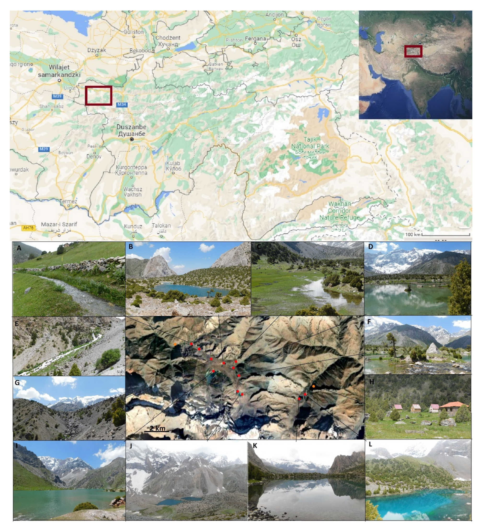
2.1. Study Area
2.2. Materials and Methods
- analysis of the visibility range (VR)—the area visible from particular points;
- vertical development (MVD), as the difference between the maximal and minimal altitude visible from particular points (relative height);
- maximum visibility range (VD), as the horizontal distance (in kilometers) at which a large dark object can just be seen against the horizon sky in daylight; and
- landscape diversity (LD) assessment—the number of land cover types, such as forests, alpine halls, and rock surfaces, visible from particular points.
3. Results
3.1. Analysis of Available Tourist Offers
3.2. Internal Value Analysis
3.3. External Value Analysis
4. Discussion
5. Conclusions
Author Contributions
Funding
Institutional Review Board Statement
Informed Consent Statement
Data Availability Statement
Acknowledgments
Conflicts of Interest
References
- Goudie, A.S. Human Impact on the Natural Environment. In Past, Present and Future; Wiley-Blackwell: Hoboken, NJ, USA, 2018; p. 472. [Google Scholar]
- Norgaard, K.M. Living in Denial. Climate Change, Emotions, and Everyday Life; The MIT Press: Cambridge, MA, USA, 2011; p. 304. [Google Scholar]
- Washington, H.; Cook, J. Climate Change Denial. Heads in The Sand; Earthscan: London, UK; New York, NY, USA, 2013; p. 244. [Google Scholar]
- Rubin, V. Disinformation and misinformation triangle: A conceptual model for “fake news” epidemic, causal factors and interventions. J. Doc. 2019, 75, 1013–1034. [Google Scholar] [CrossRef]
- Markiewicz-Patkowska, J.; Widawski, K.; Oleśniewicz, P. Conditionings of the educational function of senior tourism on the example of seniors from Wroclaw. Educ. Altern. 2017, 15, 402–411. [Google Scholar]
- Pytel, S.; Szkup, R. Kształceniowa funkcja wyjazdów turystycznych seniorów i młodzieży. Ekon. Probl. Tur. 2018, 42, 115–123. [Google Scholar] [CrossRef]
- Singh, R.L.; Singh, P.K. Global Environmental Problems. In Principles and Applications of Environmental Biotechnology for a Sustainable Future; Singh, R., Ed.; Applied Environmental Science and Engineering for a Sustainable Future; Springer: Singapore, 2016; pp. 13–41. [Google Scholar] [CrossRef]
- Beuhler, M. Potential impacts of global warming on water resources in southern California. Water Sci. Technol. 2003, 47, 165–168. [Google Scholar] [CrossRef] [PubMed]
- Jeppesen, J.; Brucet, S.; Naselli-Flores, L.; Papastergiadou, E.; Stefanidis, K.; Nõges, T.; Nõges, P.; Attayde, J.L.; Zohary, T.; Coppens, J.; et al. Ecological impacts of global warming and water abstraction on lakes and reservoirs due to changes in water level and related changes in salinity. Hydrobiologia 2015, 750, 201–227. [Google Scholar] [CrossRef]
- Rice, J.R.; Joyce, L.A.; Regan, C.; Winters, D.; Truex, R. Climate Change Vulnerability Assessment of Aquatic and Terrestrial Ecosystems in the U.S. Forest Service Rocky Mountain Region; General Technical Report RMRS-GTR-376; Department of Agriculture, Forest Service, Rocky Mountain Research Station: Fort Collins, CO, USA, 2018; p. 216. [Google Scholar]
- Veettil, B.K.; Kamp, U. Global Disappearance of Tropical Mountain Glaciers: Observations, Causes, and Challenges. Geosciences 2019, 9, 196. [Google Scholar] [CrossRef] [Green Version]
- Pritchard, H.D. Asia’s glaciers are a regionally important buffer against drought. Nature 2017, 545, 169–174. [Google Scholar] [CrossRef] [PubMed]
- Buchroithner, M.F.; Bolch, T. Glacier Lake Outburst Floods (GLOFs)–Mapping the Hazard of a Threat to High Asia and Beyond. In Impact of Global Changes on Mountains; Grover, V.I., Borsdorf, A., Breuste, J.H., Tiwari, P.C., Witkowski Frangetto, F., Eds.; CRC Press: Boca Raton, FL, USA, 2014; pp. 324–345. [Google Scholar]
- Yin, B.; Zeng, J.; Zhang, Y.; Huai, B.; Wang, Y. Recent Kyagar glacier lake outburst flood frequency in Chinese Karakoram unprecedented over the last two centuries. Nat. Hazards 2019, 95, 877–881. [Google Scholar] [CrossRef]
- Ives, J.D.; Shrestha, R.B.; Mook, P.K. Formation of Glacial Lakes in the Hindu Kush-Himalayas and GLOF Risk Assessment; ICIMOD: Kathmandu, Nepal, 2010. [Google Scholar]
- Han, Y.; Hunag, P.; Li, L.; Shrethsa, A.B.; Bajracharya, S.R. Risk assessment and cartography of flash foods. In Case Studies on Flash Flood Risk Management in the Himalayas: In Support of Specific Flash Flood Policies; Shrethsa, A.B., Bajracharya, S.R., Eds.; ICIMOD: Kathmandu, Nepal, 2013; pp. 56–62. [Google Scholar]
- Musiał, W. Ekonomiczne i Społeczne Problemy Rozwoju Obszarów Wiejskich Karpat Polskich; IRWiR PAN: Warszawa, Poland, 2008; p. 391. [Google Scholar]
- Newsome, D.; Dowling, R. Geotourism: The Tourism of Geology and Landscape; Goodfellow Publishers Ltd.: London, UK, 2010; p. 260. [Google Scholar]
- Słomka, T.; Mayer, W. Geotourism-an interdisciplinary education program. Przegląd Geol. 2011, 59, 329–334. [Google Scholar]
- Shokirov, Q.; Abdykadyrova, A.; Dear, C.; Nowrojee, S. Mountain Tourism and Sustainability in Kyrgyzstan and Tajikistan: A Research Review; University of Central Asia: Bishkek, Kyrgyzstan, 2014; p. 61. [Google Scholar]
- Butler, R.W. The concept of the tourist area life-cycle of evolution: Implications for management of resources. Can. Geogr. 1980, 24, 5–12. [Google Scholar] [CrossRef]
- Ars, M.S.; Bohanec, M. Towards the ecotourism: A decision support model for the assessment of sustainability of mountain huts in the Alps. J. Environ. Manag. 2010, 91, 2554–2564. [Google Scholar] [CrossRef]
- Izquierdo, A.E.; Grau, H.R.; Navarro, C.J.; Casagranda, E.; Castilla, M.C.; Grau, A. Highlands in Transition: Urbanization, Pastoralism, Mining, Tourism, and Wildlife in the Argentinian Puna. Mt. Res. Dev. 2018, 38, 390–400. [Google Scholar] [CrossRef]
- Godde, P.; Price, M.F.; Zimmermann, F.M. Tourism and Development in Mountain Regions; CABI Publishing: Oxfordshire, UK, 2000; p. 352. [Google Scholar]
- Migoń, P. Geoturystyka; PWN: Warszawa, Poland, 2012; p. 265. [Google Scholar]
- Simić, S. Hydrological Heritage in the System of Nature Protection in Serbia. Master’s Thesis, University of Belgrade-Faculty of Geography, Belgrade, Serbia, 2009. [Google Scholar]
- Miljković, D.; Božić, S.; Miljković, L.; Marković, S.B.; Lukić, T.; Jovanović, M.; Bjelajac, D.; Vasiljević, D.A.; Vujičić, M.D.; Ristanović, B. Geosite Assessment Using Three Different Methods; a Comparative Study of the Krupaja and the Žagubica Springs–Hydrological Heritage of Serbia. Open Geosci. 2018, 10, 192–208. [Google Scholar] [CrossRef]
- Mijović, D.; Dragišić, V.; Nikić, Z. Inventory of the hydrogeological heritage of Serbia. Prot. Nat. 2009, 60, 397–410. [Google Scholar]
- Strba, L. Identification and evaluation of geosites along existing tourist trail as a primary step of geotourism development: Case study from the Spiš region (Slovakia). Geoj. Tour. Geosites 2015, 16, 127–141. [Google Scholar]
- Bonachea, J.; Bruschi, V.; Remondo, J.; González-Díez, A.; Salas, L.; Bertens, J.; Cendrero, A.; Otero, C.; Giusti, C.; Fabbri, A.; et al. An approach for quantifying geomorphological impacts for EIA of transportation infrastructures: A case study in northern Spain. Geomorphology 2005, 66, 95–117. [Google Scholar] [CrossRef]
- Bruschi, V.; Cendrero, A. Geosite evaluation: Can we measure intangible values? II Quaternario 2005, 18, 293–306. [Google Scholar]
- Coratza, P.; Giusti, C. Methodological proposal for the assessment of the scientific quality of geomorphosites. II Quaternario 2005, 18, 307–313. [Google Scholar]
- Pralong, J.-P. A method for assessing tourist potential and use of geomorphological sites. Géomorphologie Relief Process. Environ. 2005, 3, 189–196. [Google Scholar] [CrossRef]
- Serrano, E.; Gonzalez-Trueba, J. Assessment of geomorphosites in natural protected areas: The Picos de Europa National Park (Spain). Géomorphologie Relief Process. Environ. 2005, 3, 197–208. [Google Scholar] [CrossRef] [Green Version]
- Reynard, E.; Fontana, G.; Kozlik, L.; Scapozza, C. A method for assessing “scientific” and “additional values” of geomorphosites. Geogr. Helv. 2007, 62, 148–158. [Google Scholar] [CrossRef]
- Zouros, N. Geomorphosite assessment and management in protected areas of Greece. Case study of the Lesvos island–coastal geomorphosites. Geogr. Helv. 2007, 62, 169–180. [Google Scholar] [CrossRef]
- Pereira, P.; Pereira, D.; Caetano Alves, M.I. Geomorphosite assessment in Montesinho Natural Park (Portugal). Geogr. Helv. 2007, 62, 159–168. [Google Scholar] [CrossRef] [Green Version]
- Knapik, R.; Jała, Z.; Sobczyk, A.; Migoń, P.; Aleksandrowski, P.; Szuszkiewicz, A.; Krakowski, K. Inwentaryzacja i waloryzacja geostanowisk Karkonoskiego Parku Narodowego i jego otuliny oraz wyko-nanie mapy geologicznej tego obszaru. Jelenia Góra 2009, 5–8. [Google Scholar] [CrossRef]
- Solarska, A.; Jary, Z. Geoheritage and geotourism potential of the Strzelin Hills. Geogr. Pannonica 2010, 14, 118–125. [Google Scholar] [CrossRef] [Green Version]
- Dollma, M. Geotourism potential of Thethi National Park (Albania). Int. J. Geoheritage Parks 2019, 7, 85–90. [Google Scholar] [CrossRef]
- Myga-Piątek, U. Krajobraz kulturowy jako walor i produkt turystyczny–problemy oceny i ochrony, Krajobraz kulturowy-cechy, walory, ochrona. Probl. Ekol. Kraj. 2006, 16, 201–212. [Google Scholar]
- Rahmonov, O.; Majgier, L.; Andrejczuk, W.; Banaszek, J.; Karkosz, D.; Parusel, T.; Szymczyk, A. Landscape diversity and biodiversity of Fann Mountains (Tajikistan). Ekológia 2013, 32, 388–395. [Google Scholar] [CrossRef] [Green Version]
- Opała, M.; Niedźwiedź, T.; Rahmonov, O.; Owczarek, P.; Małarzewski, Ł. Towards improving the Central Asian dendrochronological network-New data from Tajikistan, Pamir-Alay. Dendrochronologia 2017, 41, 10–23. [Google Scholar] [CrossRef]
- Rahmonov, O.; Holbegov, M.; Szczypek, T.; Snytko, V.A.; Kłys, G.; Rahmonova, M. The Consequences of Vegetation Degradation Under the Influence of Anthropogenic Activity in the Territory of the Zarafshan Range (Western Tajikistan). Geogr. Nat. Resour. 2014, 3, 193–197. [Google Scholar] [CrossRef]
- Rahmonov, O.; Rahmonov, M.; Opała-Owczarek, M.; Owczarek, P.; Niedźwiedź, T.; Myga-Piątek, U. Ecological and cultural importance of juniper ecosystem in the area of Zerafshan Valley (Tajikistan) on the background of environmental condition and anthropogenic hazards. Geogr. Pol. 2017, 90, 441–461. [Google Scholar] [CrossRef] [Green Version]
- Rahmonov, O.; Szczypek, T.; Niedźwiedź, T.; Myga-Piatek, U.; Rahmonov, M.; Snytko, V.A. The human impact on the transformation of juniper forest landscape in the western part of the Pamir-Alay range (Tajikistan). Env. Earth Sci. 2017, 76, 324. [Google Scholar] [CrossRef]
- United Nations Educational, Scientific and Cultural Organization. Fann Mountains. Available online: http://whc.unesco.org/en/tentativelists/2107/ (accessed on 7 July 2021).
- Włodkowska-Bagan, A. Problem deficytu wody w Azji Centralnej In Bezpieczeństwo obszaru poradzieckiego. Uwarunkowania-Mechanizmy-Funkcjonowanie. In Księga Pamiątkowa Profesora Kazimierza Malaka; Bryc, A., Ed.; Difin: Warszawa, Poland, 2011; pp. 376–388. [Google Scholar]
- Sodiqov, A. From Resettlement to Conflict: Development-Induced Involuntary Displacement and Violence in Tajikistan. In The Transformation of Tajikistan: The Sources of Statehood; Heathershaw, J., Herzig, E., Eds.; Routledge: New York, NY, USA, 2013; pp. 49–65. [Google Scholar]
- Myga-Piątek, U. Koncepcja zrównoważonego rozwoju w turystyce. Probl. Ekorozw. 2011, 6, 145–154. [Google Scholar]
- Nepal, S.K. Mountain Ecotourism and Sustainable Development. Mt. Res. Dev. 2002, 22, 104–109. [Google Scholar] [CrossRef] [Green Version]
- Tallar, R.Y.; Suen, J.-P. Measuring the Aesthetic Value of Multifunctional Lakes Using an Enhanced Visual Quality Method. Water 2017, 9, 233. [Google Scholar] [CrossRef]
- Rahmonov, O.; Zaurov, D.-E.; Islamov, B.I.; Eisenman, S.W. Resources along the Silk Road in Central Asia: Lagochilus inebrians Bunge (Turkestan Mint) and Medicago sativa L. (Alfalfa). In Natural Products of Silk Road Plants; Cooper, R., Deakin, J.J., Eds.; CRC Press, Taylor & Francis Group: Boca Raton, FL, USA, 2020; pp. 153–166. [Google Scholar] [CrossRef]
- Dörre, A.; Goibnazarov, C. Small-Scale Irrigation Self-Governance in a Region of Tajikistan. Mt. Res. Dev. 2018, 38, 104–113. [Google Scholar] [CrossRef]
- Rahmonov, O.; Abramowicz, A.; Pukowiec-Kurda, K.; Fagiewicz, K. The link between a high-mountain community and ecosystem services of juniper forests in Fann Mountains (Tajikistan). Ecosyst. Serv. 2021, 48, 101255. [Google Scholar] [CrossRef]
- Rogowski, M. Ocena walorów widokowych szlaków turystycznych na wybranych przykładach z Dolnego Śląska. Probl. Ekol. Kraj. 2009, 25, 155–163. [Google Scholar]
- Jiménez-García, M.; Ruiz-Chico, J.; Peña-Sánchez, A.R. Landscape and Tourism: Evolution of Research Topics. Land 2020, 9, 488. [Google Scholar] [CrossRef]
- Śleszyński, P. Z badań na fizjonomią środowiska przyrodniczego. Pr. Studia Geogr. 1997, 21, 255–297. [Google Scholar]
- Sobala, M.; Myga-Piątek, U.; Szypuła, B. Assessment of Changes in a Viewshed in the Western Carpathians Landscape as a Result of Reforestation. Land 2020, 9, 430. [Google Scholar] [CrossRef]


| Criterion | Value | |
|---|---|---|
| A. SCIENTIFIC VALUE (ScV) (maximum 5.5) | ||
| Rareness in relation to the area (Ra) | ||
| It is not one of the most important 5 | 0 | |
| It is not one of the most important 3 | 0.25 | |
| One of the most important 3 | 0.5 | |
| The most important | 0.75 | |
| The only occurrence | 1.0 | |
| In Integrity/Intactness (In) | ||
| Highly damaged as a result of human activities | 0 | |
| Damaged as a result of natural processes | 0.25 | |
| Damaged but preserving essential geomorphological features | 0.5 | |
| Slightly damaged but still maintaining the essential geomorphological features | 0.75 | |
| No visible damage | 1.0 | |
| Representativeness of geomorphological processes and pedagogical interest (Rp) | ||
| Low representativeness and without pedagogical interest | 0 | |
| With some representativeness but with low pedagogical interest | 0.33 | |
| Good example of processes but hard to explain to non-experts | 0.67 | |
| Good example of processes and/or a good pedagogical resource | 1 | |
| Number of interesting geomorphological features (diversity) (Dv) | ||
| 1 | 0 | |
| 2 | 0.33 | |
| 3 | 0.67 | |
| More than 3 | 1 | |
| Other geological features with heritage value (Hy) | ||
| Absence of other geological features | 0 | |
| Other geological features but without relation to geomorphology | 0.17 | |
| Other geological features with relation to geomorphology | 0.33 | |
| Occurrence of other geosite(s) | 0.5 | |
| Scientific knowledge on geomorphological issues (Kn) | ||
| None | 0 | |
| Medium: presentations, national papers | 0.25 | |
| High: international papers, thesis | 0.5 | |
| Rareness at national level (Ra) | ||
| More than 5 occurrences | 0 | |
| Between 3 and 5 occurrences | 0.17 | |
| 2 occurrences | 0.33 | |
| The only occurrence | 0.5 | |
| ScV Scientific value (Ra + In + Rp + Dv + Ge + Kn + Rn) | ||
| B. ADDITIONAL VALUES (AdV) (maximum 4.5) | ||
| Cultural value | Cult | |
| Without cultural features or with cultural features damaging the site | 0 | |
| Cultural features with no connection to landforms | 0.25 | |
| Relevant cultural features with no connection to landforms | 0.5 | |
| Immaterial cultural features related to landforms | 0.75 | |
| Material cultural features related to landforms | 1 | |
| Relevant material cultural features related to landforms | 1.25 | |
| Anthropic landform with high cultural relevance | 1.5 | |
| Aesthetic value | Aest | |
| Subjective value. Aspects to be considered: visual singularity of landforms; panoramic quality; objects and colour diversity and combination; presence of water and vegetation; absence of human-induced deterioration; proximity to the observed features. | Low | 0–0.5 |
| Medium | 0.5–1 | |
| high | 1–1.5 | |
| Ecological value | Ecol | |
| Without relation to biological features | 0 | |
| Occurrence of interesting fauna and/or flora | 0.38 | |
| One of the best places to observe interesting fauna and/or flora | 0.75 | |
| Geomorphological features are important for ecosystem(s) | 1.12 | |
| Geomorphological features are crucial for the ecosystem(s) | 1.5 | |
| AdV Additional values (Cult + Aest + Ecol) | ||
| C. USE VALUE (UsV) (maximum 7.0) | ||
| Accessibility | Ac | |
| Very difficult, only with special equipment | 0 | |
| Only by 4-wheel-drive vehicle and more than 500 metres by footpath | 0.21 | |
| By car and more than 500 metres by footpath | 0.43 | |
| By car and less than 500 metres by footpath | 0.64 | |
| By 4-wheel-drive vehicle and less than 100 metres by footpath | 0.86 | |
| By car to camp base and less than 50 metres by footpath | 1.07 | |
| By car on local roads and less than 1000 metres by footpath | 1.29 | |
| By car on national roads and less than 50 metres by footpath | 1.5 | |
| Visibility | Vi | |
| Very difficult to view or not visible at all | 0 | |
| Can only be viewed using special equipment (e.g., artificial light, ropes) | 0.3 | |
| Limited by trees or lower vegetation | 0.6 | |
| Good but need to move around for a complete observation | 0.9 | |
| Good for all relevant geomorphological features | 1.2 | |
| Excellent for all relevant geomorphological features | 1.5 | |
| Present use of the geomorphological interest | Gu | |
| Without promotion and not being used | 0 | |
| Without promotion but being used | 0.33 | |
| Promoted/used as a landscape site | 0.67 | |
| Promoted/used as a geomorphosite or geosite | 1 | |
| Present use of other natural and cultural interests | Ou | |
| Without other interests, promotion, and use | 0 | |
| With other interests but without promotion and use | 0.33 | |
| With other interests and their promotion, but without other use | 0.67 | |
| With other interests, with promotion and use | 1 | |
| Legal protection and use limitations | Lp | |
| With total protection and prohibitive use | 0 | |
| With protection, with use restriction | 0.33 | |
| Without protection and without use restriction | 0.67 | |
| With protection but without use restriction or with very low use restriction | 1 | |
| Equipment and support services | Eq | |
| Hostelry and support services are more than 25 km away | 0 | |
| Hostelry and support services are between 10 and 25 km away | 0.25 | |
| Hostelry and support services are between 5 and 10 km away | 0.5 | |
| Hostelry or support services are less than 5 km away | 0.75 | |
| Hostelry and support services are less than 5 km away | 1 | |
| UsV Use value (Ac + Vi + Gu + Ou + Lp + Eq) | ||
| Name of Offer | Point of Tour in Investigated Area (Hydroeosites) | Duration | Country of Origin of Offer/Organiser | Type of Tourism | Price | Source of Information |
| Tajikistan Trekking Tour | Artuch Camp, Kuli Kalon Lakes, Alouddin Lakes, Iskandar Kul | 11 days | Switzerland/Kalpak Travel | hiking, trekking | 1890 EUR | kalpak-travel.com |
| Fann Mountains Trek and Silk Road Cities | Atruch Base Camp, Kuli Kalon Lakes, Alouddin Lakes, Mutnoye Lake | 14 days (5-day trek) | United Kingdom/World Expeditions | hiking, trekking | 2270 EUR | worldexpeditions.com |
| Trekking Fann Mountains | Artuch Base Camp, Kuli Kalon Lakes, Bibijannat Lake, Alouddin Pass, Alouddin Lakes, Mutnoye Lake | 4-day trek | Kyrgyz/Visit Alay | hiking, trekking | no data | visitalay.com |
| Trekking in Fann Mountains | Atruch Base Camp, Chukurak Lake, Kuli Kalon Lakes, Bibijannat Lakes, Alouddin Lakes, Alouddin Pass, Mutnoye Lake, Vertikal Camp | 6-day trek | Tajikistan/Paramount Journey | hiking, trekking | no data | paramountjourney.com |
| Heartland of Fann Mountains | Artuch Base Camp, Kuli Kalon Lakes, Alouddin Lakes, Mutnoye Lake, Chimtarga Pass | 8 days | Uzbekistan/Kyrgyzstan/Russia/Central Asia Travel | hiking, trekking, climbing | 1295 USD | centralasia-travel.com |
| Fann Mountains. Trekking in Fann Mountains | Lake Chukurak, Kuli Kalon Lakes, Bibijanat Lake, Dushakha Lakes, Alouddin Pass, Alouddin Lakes, Mutnoye Lake, Chimtarga Pass, Allo Lakes, Munora Pass, Mazguzor Lake | 12–14 days | Russia/ClimberCA Mountaineering Asia | trekking, hiking, climbing | no data | climberca.com |
| Trekking in Fann Mountains | Artuch Base Camp, Bibijanat Lake, Kuli Kalon Lakes, Alouddin Lakes, Iskandarkul Lake | 8 days | Tajikistan/Viator | trekking, hiking | 1443 USD | viator.com |
| Climb Chimtarga (5489 m) and trek the Fann Mountains, Tajikistan | Artuch, Kuli Kalon Lakes, Chukurak Lakes, Alouddin Pass, Alouddin Lakes, Mutnoye Lake, Energia, Mirali Pass, Chmitarga Pass, Chimtarga, Allo Lake | 16 days | United Kingdom/Remote Corner Adventures | trekking, hiking, climbing | 2099 USD | remote-corner.com |
| Trekking in Fann Mountains | Artuch, Bibijanat Lake, Kuli Kalon Lakes, Alouddin Pass, Alouddin Lakes, Iskanderkul Lake, | 8 days | Tajikistan/Indy Guide | trekking, hiking | 699 USD | indy-guide.com |
| Tajikistan Trekking Tour | Artuch Camp, Kuli Kalon Lakes, Alouddin Lakes, Iskandar Kul | 11 days | Switzerland/Kalpak Travel | hiking, trekking | 1890 EUR | kalpak-travel.com |
| Fann Mountains Trek and Silk Road Cities | Atruch Base Camp, Kuli Kalon Lakes, Alouddin Lakes, Mutnoye Lake | 14 days (5-day trek) | United Kingdom/World Expeditions | hiking, trekking | 2270 EUR | worldexpeditions.com |
| Trekking Fann Mountains | Artuch Base Camp, Kuli Kalon Lakes, Bibijannat Lake, Alouddin Pass, Alouddin Lakes, Mutnoye Lake | 4-day trek | Kyrgyz/Visit Alay | hiking, trekking | no data | visitalay.com |
| Trekking in Fann Mountains | Atruch Base Camp, Chukurak Lake, Kuli Kalon Lakes, Bibijannat Lakes, Alouddin Lakes, Alouddin Pass, Mutnoye Lake, Vertikal Camp | 6-day trek | Tajikistan/Paramount Journey | hiking, trekking | no data | paramountjourney.com |
| Heartland of Fann Mountains | Artuch Base Camp, Kuli Kalon Lakes, Alouddin Lakes, Mutnoye Lake, Chimtarga Pass | 8 days | Uzbekistan/Kyrgyzstan/Russia/Central Asia Travel | hiking, trekking, climbing | 1295 USD | centralasia-travel.com |
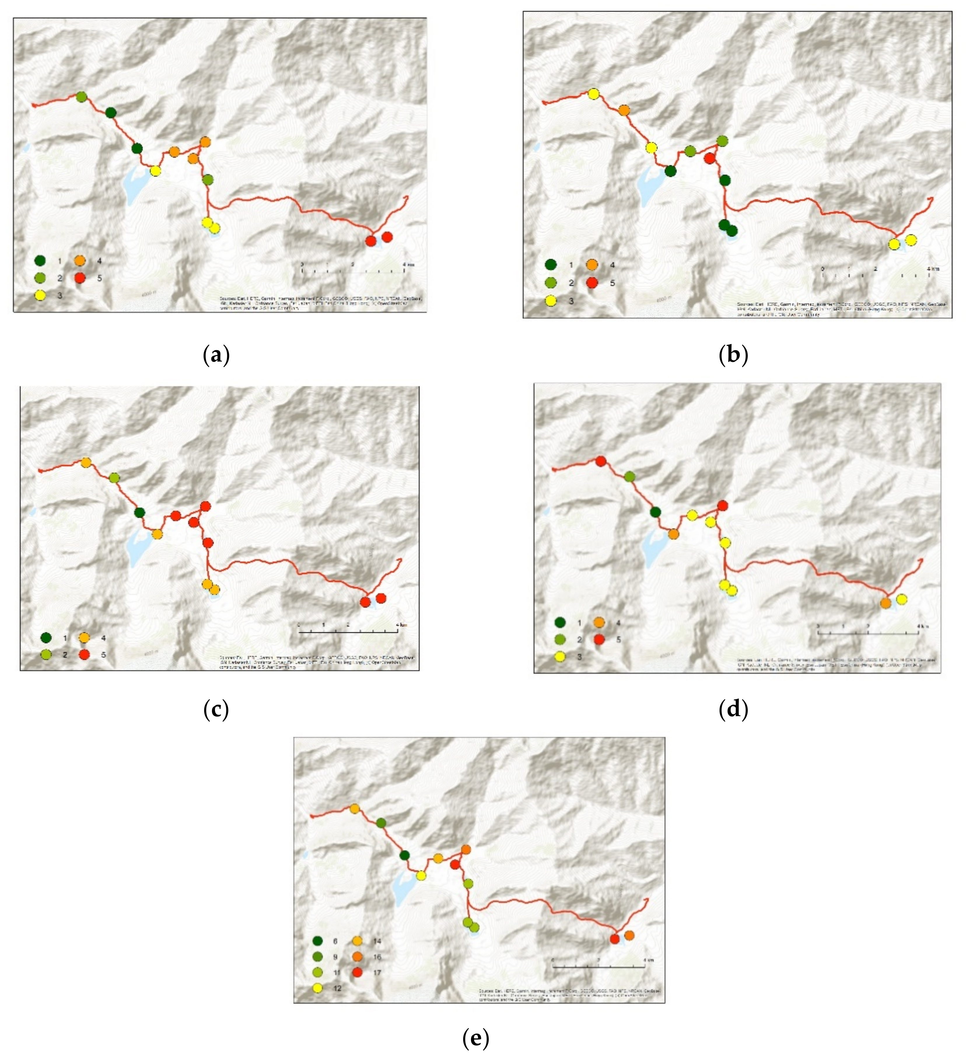
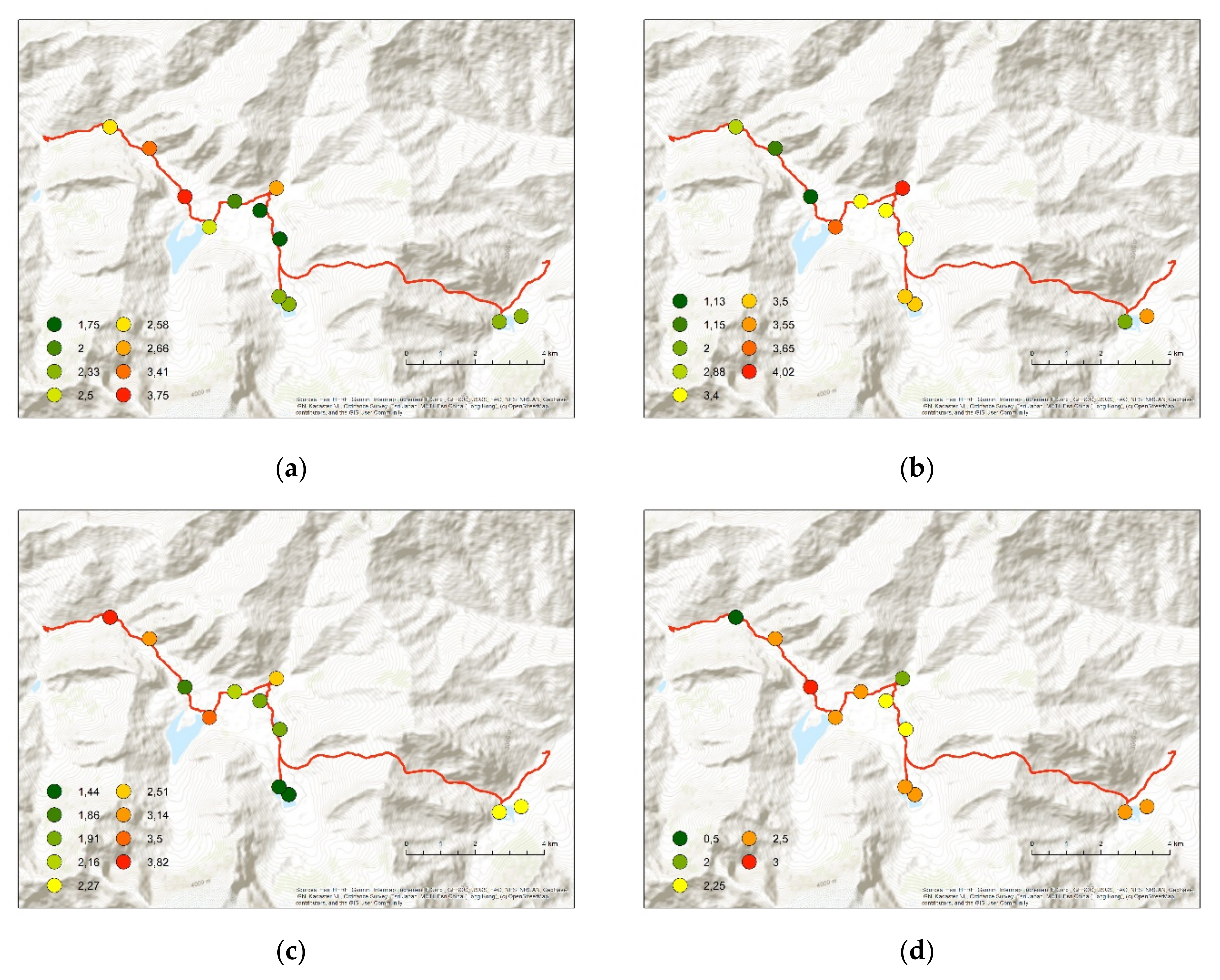
| Assessment Criteria/Hydrogeosites | Alouddin Lake 1 | Alouddin Lake 2 | Dushakha Lake 1 | Dushakha Lake 2 | Bibijonat Lake | Swampland in Kuli Kalon Plateau | Kuli Kalon Lake 1 | Kuli Kalin Lake 2 | Great Kuli Kalon Lake | Exsurgent in Urech Valley | Waterfall in Urech Valley | Irrigation Channels in Urech Valley |
|---|---|---|---|---|---|---|---|---|---|---|---|---|
| ScV | ||||||||||||
| RA | 0 | 0 | 0 | 0 | 0 | 0 | 0 | 0 | 0 | 0.75 | 0.75 | 0.75 |
| IN | 1 | 1 | 1 | 1 | 0.75 | 1 | 0.75 | 1 | 1 | 1 | 1 | 0.5 |
| RP | 1 | 1 | 1 | 1 | 0.67 | 1 | 0.67 | 0.67 | 1 | 1 | 1 | 1 |
| DV | 0 | 0 | 0 | 0 | 0 | 0.33 | 0 | 0 | 0 | 0.67 | 0.33 | 0.33 |
| HY | 0.33 | 0.33 | 0.33 | 0.33 | 0.33 | 0.33 | 0.33 | 0.33 | 0.5 | 0.33 | 0.33 | 0 |
| KN | 0 | 0 | 0 | 0 | 0 | 0 | 0 | 0 | 0 | 0 | 0 | 0 |
| RN | 0 | 0 | 0 | 0 | 0 | 0 | 0 | 0 | 0 | 0 | 0 | 0 |
| Sum of ScV | 2.33 | 2.33 | 2.33 | 2.33 | 1.75 | 2.66 | 1.75 | 2 | 2.5 | 3.75 | 3.41 | 2.58 |
| AdV | ||||||||||||
| CULT | 1.5 | 0 | 1.5 | 1.5 | 1.5 | 1.5 | 1.5 | 1.5 | 1.5 | 0 | 0 | 1.5 |
| AEST | 1.35 | 1.25 | 1.25 | 1.25 | 1.15 | 1.4 | 1.15 | 1.15 | 1.4 | 0.75 | 1.15 | 1 |
| ECOL | 0.75 | 0.75 | 0.75 | 0.75 | 0.75 | 1.12 | 0.75 | 0.75 | 0.75 | 0.38 | 0 | 0.38 |
| Sum of AdV | 3.55 | 2 | 3.5 | 3.5 | 3.40 | 4.02 | 3.4 | 3.4 | 3.65 | 1.13 | 1.15 | 2.88 |
| UsV | ||||||||||||
| Ac | 0.29 | 0.29 | 0.21 | 0.21 | 0.43 | 0.43 | 0.43 | 0.43 | 0.43 | 0.43 | 0.86 | 1.5 |
| Vi | 0.9 | 0.9 | 0.9 | 0.9 | 0.9 | 1.5 | 0.9 | 0.9 | 0.9 | 0.6 | 1.2 | 0.9 |
| Hu | 0 | 0 | 0 | 0 | 0 | 0 | 0 | 0 | 0.67 | 0 | 0 | 0 |
| Ou | 0 | 0 | 0 | 0 | 0 | 0 | 0 | 0 | 0.67 | 0 | 0 | 0 |
| Lp | 0.33 | 0.33 | 0.33 | 0.33 | 0.33 | 0.33 | 0.33 | 0.33 | 0.33 | 0.33 | 0.33 | 0.67 |
| Eq | 0.75 | 0.75 | 0 | 0 | 0.25 | 0.25 | 0.25 | 0.5 | 0.5 | 0.5 | 0.75 | 0.75 |
| Sum of UsV | 2.27 | 2.27 | 1.44 | 1.44 | 1.91 | 2.51 | 1.91 | 2.16 | 3.5 | 1.86 | 3.14 | 3.82 |
| VPr | ||||||||||||
| IN | 1 | 1 | 1 | 1 | 0.75 | 1 | 0.75 | 1 | 1 | 1 | 0.5 | 0.5 |
| VU | 1.5 | 1.5 | 1.5 | 1.5 | 1.5 | 1 | 1.5 | 1.5 | 1.5 | 2 | 2 | 0 |
| Sum of VPr | 2.5 | 2.5 | 2.5 | 2.5 | 2.25 | 2 | 2.25 | 2.5 | 2.5 | 3 | 2.5 | 0.5 |
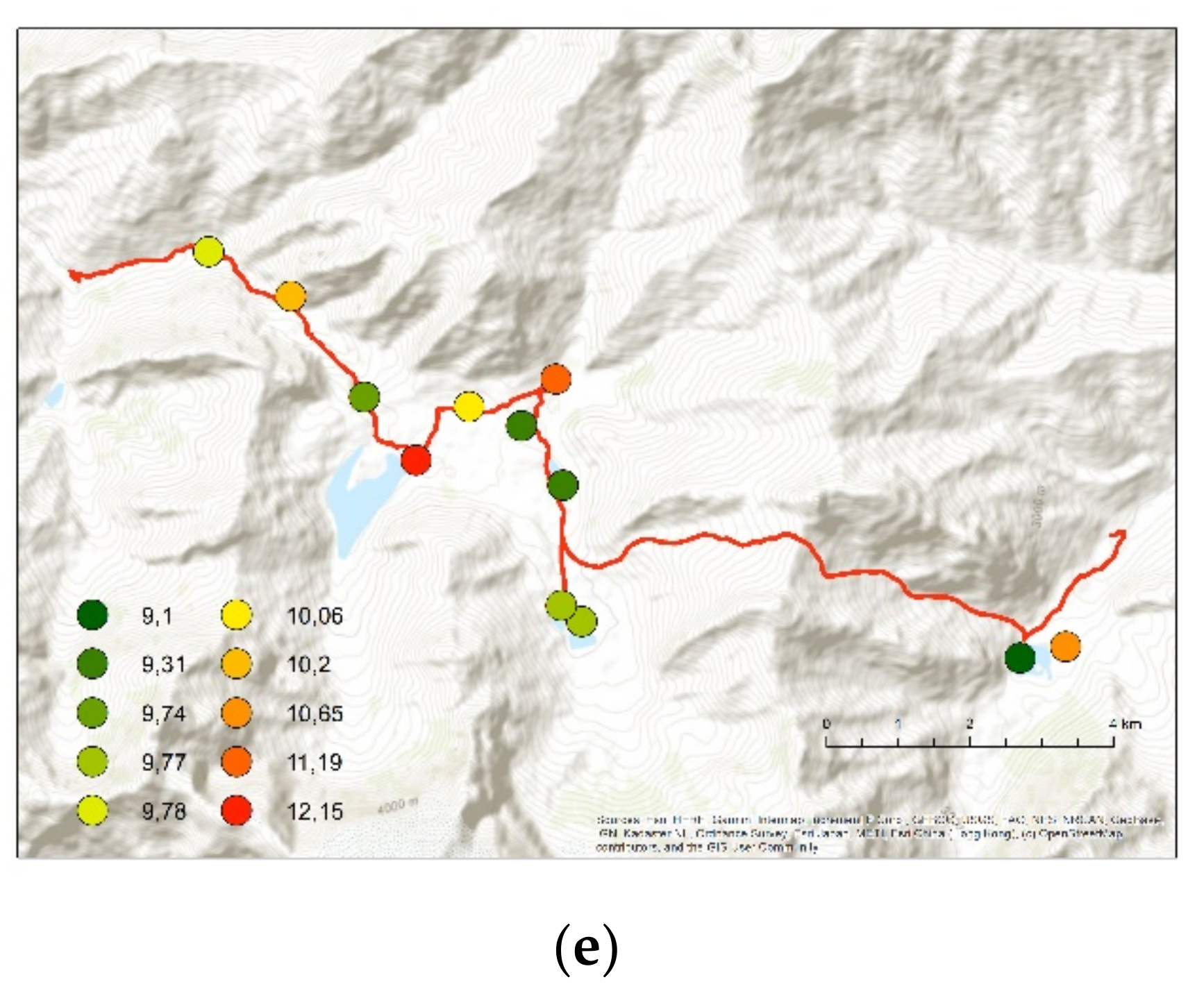
| Sum of ScV + AdV + UsV + VPr | 10.65 | 9.1 | 9.77 | 9.77 | 9.31 | 11.19 | 9.31 | 10.06 | 12.15 | 9.74 | 10.2 | 9.78 |
| Assessment Criteria/Hydrogeosites | Alouddin Lake 1 | Alouddin Lake 2 | Dushakha Lake 1 | Dushakha Lake 2 | Bibijonat Lake | Swampland in Kuli Kalon Plateau | Kuli Kalon Lake 1 | Kulikalin Lake 2 | Great Kuli Kalon Lake | Exsurgent in Urech Valley | Waterfall in Urech Valley | Irrigation Channels in Urech Valley |
|---|---|---|---|---|---|---|---|---|---|---|---|---|
| SuV | ||||||||||||
| VR (km2) | 48.3 | 47.5 | 24.3 | 27 | 17.7 | 35.3 | 36.5 | 32.9 | 27.6 | 4.2 | 9 | 13.4 |
| MVD (km) | 16.5 | 18.7 | 8.4 | 8.3 | 6.6 | 11 | 31.3 | 13.7 | 7.7 | 12 | 20.1 | 19.4 |
| VD (m) | 2225 | 2380 | 2219 | 2059 | 2416 | 2434 | 2438 | 2451 | 1910 | 568 | 1240 | 2178 |
| LD | 5 | 6 | 5 | 5 | 5 | 7 | 5 | 5 | 6 | 3 | 4 | 7 |
| Assessment Criteria/Hydrogeosites | Alouddin Lake 1 | Alouddin Lake 2 | Dushakha Lake 1 | Dushakha Lake 2 | Bibijonat Lake | Swampland in Kuli Kalon Plateau | Kuli Kalon Lake 1 | Kulikalin Lake 2 | Great Kuli Kalon Lake | Exsurgent in Urech Valley | Waterfall in Urech Valley | Irrigation Channels in Urech Valley |
|---|---|---|---|---|---|---|---|---|---|---|---|---|
| SuV | ||||||||||||
| VR | 5 | 5 | 3 | 3 | 2 | 4 | 4 | 4 | 3 | 1 | 1 | 2 |
| MVD | 3 | 3 | 1 | 1 | 1 | 2 | 5 | 2 | 1 | 3 | 4 | 3 |
| VD | 5 | 5 | 4 | 4 | 5 | 5 | 5 | 5 | 4 | 1 | 2 | 4 |
| LD | 3 | 4 | 3 | 3 | 3 | 5 | 3 | 3 | 4 | 1 | 2 | 5 |
| Sum of SuV | 16 | 17 | 11 | 11 | 11 | 16 | 17 | 14 | 12 | 6 | 9 | 14 |
Publisher’s Note: MDPI stays neutral with regard to jurisdictional claims in published maps and institutional affiliations. |
© 2021 by the authors. Licensee MDPI, Basel, Switzerland. This article is an open access article distributed under the terms and conditions of the Creative Commons Attribution (CC BY) license (https://creativecommons.org/licenses/by/4.0/).
Share and Cite
Pukowiec-Kurda, K.; Rahmonov, O.; Sobala, M.; Myga-Piątek, U. The Assessment of Hydrogeosites in the Fann Mountains, Tajikistan as a Basis for Sustainable Tourism. Resources 2021, 10, 126. https://doi.org/10.3390/resources10120126
Pukowiec-Kurda K, Rahmonov O, Sobala M, Myga-Piątek U. The Assessment of Hydrogeosites in the Fann Mountains, Tajikistan as a Basis for Sustainable Tourism. Resources. 2021; 10(12):126. https://doi.org/10.3390/resources10120126
Chicago/Turabian StylePukowiec-Kurda, Katarzyna, Oimahmad Rahmonov, Michał Sobala, and Urszula Myga-Piątek. 2021. "The Assessment of Hydrogeosites in the Fann Mountains, Tajikistan as a Basis for Sustainable Tourism" Resources 10, no. 12: 126. https://doi.org/10.3390/resources10120126
APA StylePukowiec-Kurda, K., Rahmonov, O., Sobala, M., & Myga-Piątek, U. (2021). The Assessment of Hydrogeosites in the Fann Mountains, Tajikistan as a Basis for Sustainable Tourism. Resources, 10(12), 126. https://doi.org/10.3390/resources10120126