
Factors Affecting Shark Detection from Drone Patrols in Southeast Queensland, Eastern Australia


Abstract
:Simple Summary
Abstract
1. Introduction
2. Materials and Methods
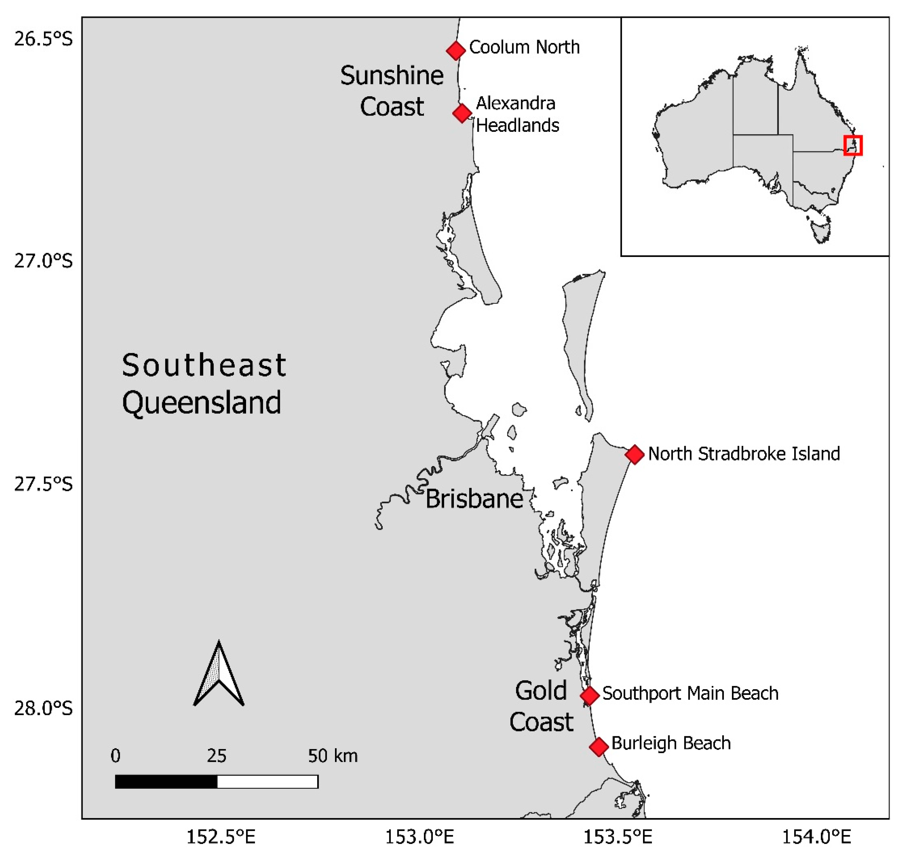
2.1. Study Location
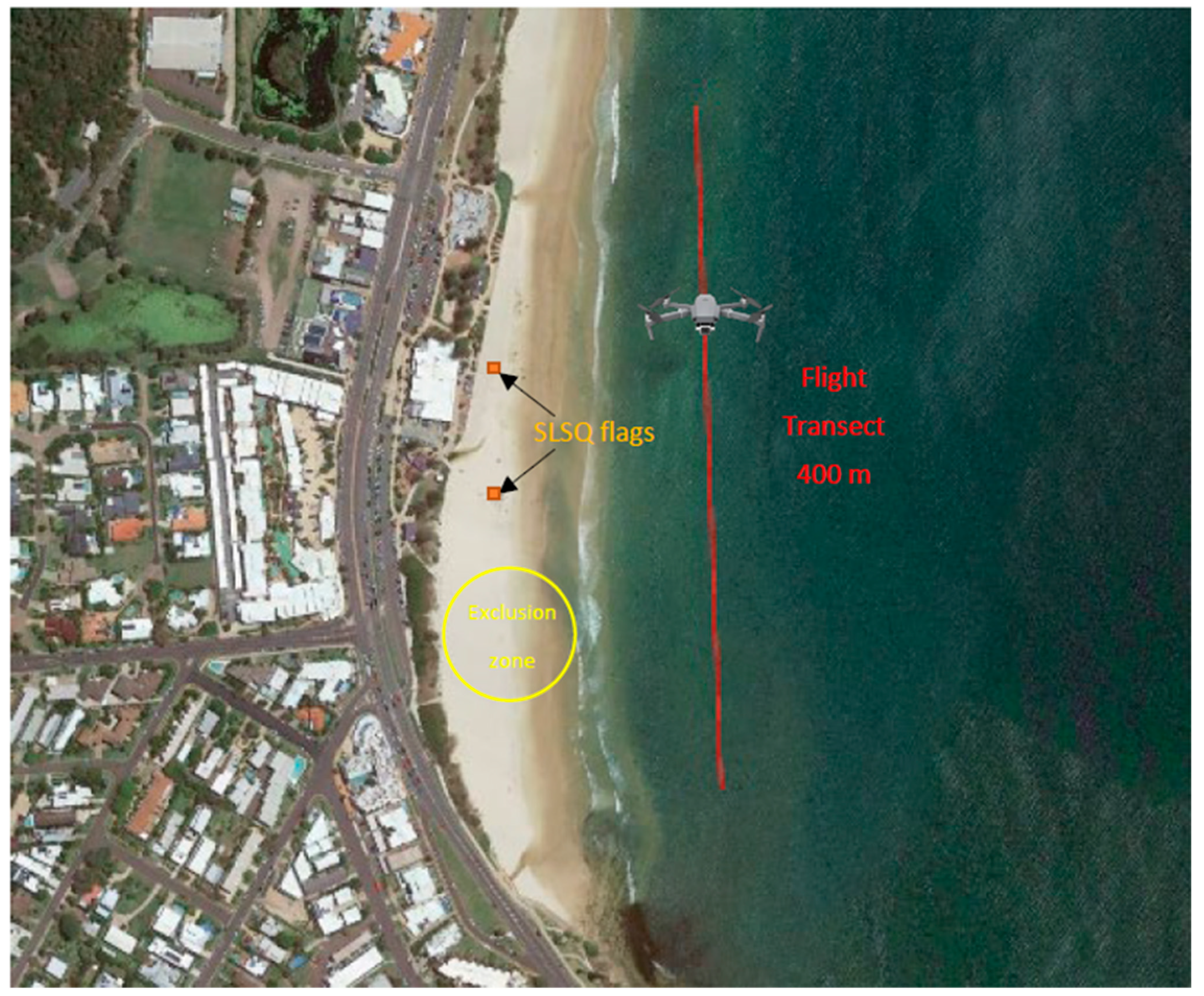
2.2. Drone Flights
2.3. Data Collection
2.4. Data Analysis
3. Results
3.1. Operational Results
3.2. Shark Sighting Rates
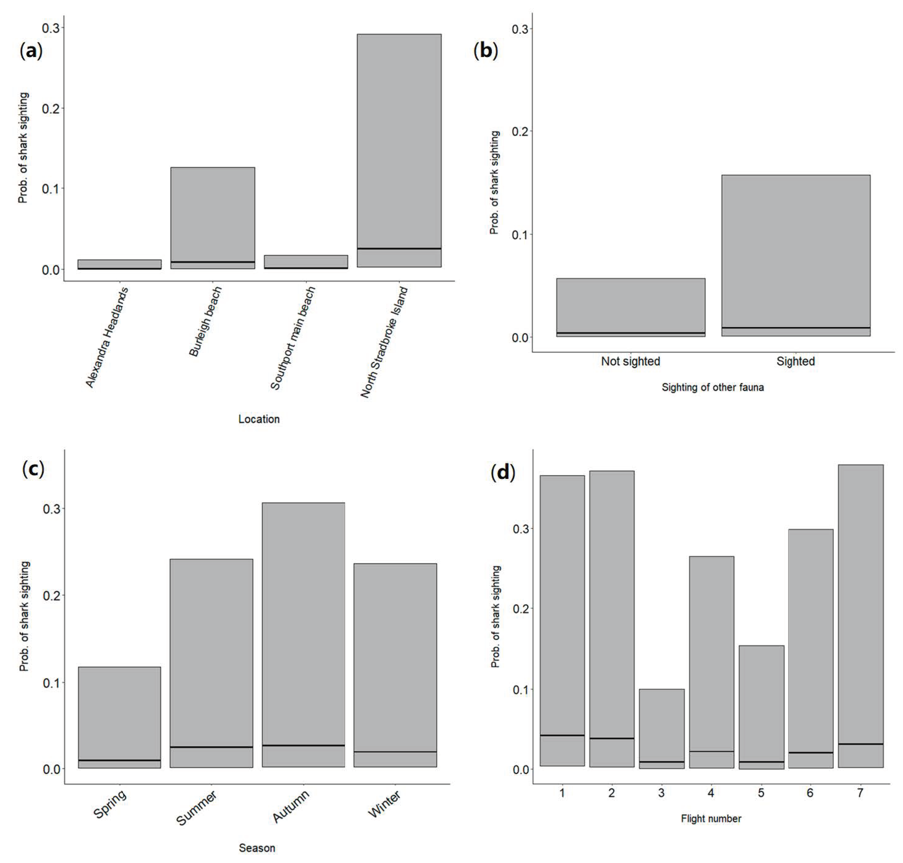
3.3. Assessing the Influence of Environmental and Operational Factors on the Probability of Sighting a Shark
4. Discussion
4.1. Operational Results
4.2. Shark Sighting Rates
4.3. Assessing the Influence of Environmental and Operational Factors on the Probability of Sighting a Shark
4.4. Future Directions
5. Conclusions
Supplementary Materials
Author Contributions
Funding
Institutional Review Board Statement
Informed Consent Statement
Data Availability Statement
Acknowledgments
Conflicts of Interest
References
- Benavides, M.T.; Fodrie, F.J.; Johnston, D.W. Shark detection probability from aerial drone surveys within a temperate estuary. J. Unmanned Veh. Syst. 2019, 8, 44–56. [Google Scholar] [CrossRef]
- Schofield, G.; Esteban, N.; Katselidis, K.A.; Hays, G.C. Drones for research on sea turtles and other marine vertebrates–A review. Biol. Conserv. 2019, 238, 108214. [Google Scholar] [CrossRef]
- Raoult, V.; Tosetto, L.; Williamson, J.E. Drone-based high-resolution tracking of aquatic vertebrates. Drones 2018, 2, 37. [Google Scholar] [CrossRef] [Green Version]
- Torres, L.G.; Nieukirk, S.L.; Lemos, L.; Chandler, T.E. Drone up! Quantifying whale behavior from a new perspective improves observational capacity. Front. Mar. Sci. 2018, 5, 319. [Google Scholar] [CrossRef] [Green Version]
- Bloom, D.; Butcher, P.A.; Colefax, A.P.; Provost, E.J.; Cullis, B.R.; Kelaher, B.P. Drones detect illegal and derelict crab traps in a shallow water estuary. Fish. Manag. Ecol. 2019, 26, 311–318. [Google Scholar] [CrossRef]
- Provost, E.J.; Butcher, P.A.; Coleman, M.A.; Bloom, D.; Kelaher, B.P. Aerial drone technology can assist compliance of trap fisheries. Fish. Manag. Ecol. 2020, 27, 381–388. [Google Scholar] [CrossRef]
- Provost, E.J.; Butcher, P.A.; Colefax, A.P.; Coleman, M.A.; Curley, B.G.; Kelaher, B.P. Using drones to quantify beach users across a range of environmental conditions. J. Coast. Conserv. 2019, 23, 633–642. [Google Scholar] [CrossRef]
- Colefax, A.P.; Butcher, P.A.; Kelaher, B.P. The potential for unmanned aerial vehicles (UAVs) to conduct marine fauna surveys in place of manned aircraft. ICES J. Mar. Sci. 2018, 75, 1–8. [Google Scholar] [CrossRef] [Green Version]
- Butcher, P.A.; Piddocke, T.P.; Colefax, A.P.; Hoade, B.; Peddemors, V.M.; Borg, L.; Cullis, B.R. Beach safety: Can drones provide a platform for sighting sharks? Wildl. Res. 2019, 46, 701–712. [Google Scholar] [CrossRef] [Green Version]
- Colefax, A.P.; Butcher, P.A.; Pagendam, D.E.; Kelaher, B.P. Reliability of marine faunal detections in drone-based monitoring. Ocean Coast. Manag. 2019, 174, 108–115. [Google Scholar] [CrossRef]
- Kelaher, B.P.; Colefax, A.P.; Tagliafico, A.; Bishop, M.J.; Giles, A.; Butcher, P.A. Assessing variation in assemblages of large marine fauna off ocean beaches using drones. Mar. Freshw. Res. 2020, 71, 68–77. [Google Scholar] [CrossRef] [Green Version]
- Colefax, A.P.; Kelaher, B.P.; Walsh, A.J.; Purcell, C.R.; Pagendam, D.E.; Cagnazzi, D.; Butcher, P.A. Identifying optimal wavelengths to maximise the detection rates of marine fauna from aerial surveys. Biol. Conserv. 2021, 257, 109102. [Google Scholar] [CrossRef]
- Colefax, A.P.; Kelaher, B.P.; Pagendam, D.E.; Butcher, P.A. Assessing white shark (Carcharodon carcharias) behavior along coastal beaches for conservation-focused shark mitigation. Front. Mar. Sci. 2020, 7, 268. [Google Scholar] [CrossRef]
- Tucker, J.P.; Colefax, A.P.; Santos, I.R.; Kelaher, B.P.; Pagendam, D.E.; Butcher, P.A. White shark behaviour altered by stranded whale carcasses: Insights from drones and implications for beach management. Ocean Coast. Manag. 2021, 200, 105477. [Google Scholar] [CrossRef]
- Tagliafico, A.; Butcher, P.A.; Colefax, A.P.; Clark, G.F.; Kelaher, B.P. Variation in cownose ray Rhinoptera neglecta abundance and group size on the central east coast of Australia. J. Fish Biol. 2020, 96, 427–433. [Google Scholar] [CrossRef]
- Stokes, D.; Apps, K.; Butcher, P.A.; Weiler, B.; Luke, H.; Colefax, A.P. Beach-user perceptions and attitudes towards drone surveillance as a shark-bite mitigation tool. Mar. Pol. 2020, 120, 104127. [Google Scholar] [CrossRef]
- DAF. SharkSmart Drone Trial Community Sentiment Report; Queensland Government, Department of Agriculture and Fisheries: Brisbane, Australia, 2021. [Google Scholar]
- Mitchell, J.D.; Scott-Holland, T.S.; Argent, J.; Emmert, K.; Butcher, P.A.; Meager, J.; Mikitis, M. Queensland SharkSmart Drone Trial Final Report; Queensland Government, Department of Agriculture and Fisheries: Brisbane, Australia, 2022. [Google Scholar]
- Colefax, A.; Butcher, P.A.; Kelaher, B. Shark Identification by Drone: Your ID Tool. Available online: https://www.youtube.com/watch?v=nxh2Pp5gq3k (accessed on 12 February 2021).
- Akaike, H. A new look at statistical model identification. IEEE Trans. Automat. Contr. 1974, 19, 716–723. [Google Scholar] [CrossRef]
- R Core Team. R: A Language and Environment for Statistical Computing; R Foundation for Statistical Computing: Vienna, Austria, 2022; Available online: https://www.R-project.org/ (accessed on 12 March 2021).
- Bates, D.; Mächler, M.; Bolker, B.; Walker, S. Fitting Linear Mixed-Effects Models Using lme4. J. Stat. Softw. 2015, 67, 1–48. [Google Scholar] [CrossRef]
- Heupel, M.; Simpfendorfer, C.; Hueter, R. Running before the storm: Blacktip sharks respond to falling barometric pressure associated with Tropical Storm Gabrielle. J. Fish Biol. 2003, 63, 1357–1363. [Google Scholar] [CrossRef]
- Udyawer, V.; Chin, A.; Knip, D.M.; Simpfendorfer, C.A.; Heupel, M.R. Variable response of coastal sharks to severe tropical storms: Environmental cues and changes in space use. Mar. Ecol. Prog. Ser. 2013, 480, 171–183. [Google Scholar] [CrossRef]
- West, G.J.; Stevens, J.D. Archival tagging of school shark, Galeorhinus galeus, in Australia: Initial results. In The Behavior and Sensory Biology of Elasmobranch Fishes: An Anthology in Memory of Donald Richard Nelson; Tricas, T.C., Gruber, S.H., Eds.; Springer: Dordrecht, Germany, 2001; Volume 20, pp. 283–298. [Google Scholar] [CrossRef]
- Lipscombe, R.S.; Spaet, J.L.; Scott, A.; Lam, C.H.; Brand, C.P.; Butcher, P.A. Habitat use and movement patterns of tiger sharks (Galeocerdo cuvier) in eastern Australian waters. ICES J. Mar. Sci. 2020, 77, 3127–3137. [Google Scholar] [CrossRef]
- Spaet, J.; Patterson, T.; Bradford, R.; Butcher, P. Spatiotemporal distribution patterns of immature Australasian white sharks (Carcharodon carcharias). Sci. Rep. 2020, 10, 10169. [Google Scholar] [CrossRef] [PubMed]
- Espinoza, M.; Lédée, E.; Smoothey, A.F.; Heupel, M.R.; Peddemors, V.M.; Tobin, A.F.; Simpfendorfer, C. Intra-specific variation in movement and habitat connectivity of a mobile predator revealed by acoustic telemetry and network analyses. Mar. Biol. 2021, 168, 80. [Google Scholar] [CrossRef]
- Holmes, B.J.; Pepperell, J.G.; Griffiths, S.P.; Jaine, F.R.A.; Tibbetts, I.R.; Bennett, M.B. Tiger shark (Galeocerdo cuvier) movement patterns and habitat use determined by satellite tagging in eastern Australian waters. Mar. Biol. 2014, 161, 2645–2658. [Google Scholar] [CrossRef]
- Guyomard, D.; Perry, C.; Tournoux, P.U.; Cliff, G.; Peddemors, V.; Jaquemet, S. An innovative fishing gear to enhance the release of non-target species in coastal shark-control programs: The SMART (shark management alert in real-time) drumline. Fish. Res. 2019, 216, 6–17. [Google Scholar] [CrossRef]
- Saqib, M.; Khan, S.D.; Sharma, N.; Scully-Power, P.; Butcher, P.; Colefax, A.; Blumenstein, M. Real-time drone surveillance and population estimation of marine animals from aerial imagery. In Proceedings of the International Conference on Image and Vision Computing, Auckland, New Zealand, 19–21 November 2018. [Google Scholar]
- Purcell, C.; Walsh, A.; Colefax, A.P.; Butcher, P.A. Assessing the ability of deep learning techniques to perform real-time identification of shark species in live streaming video from drones. Front. Mar. Sci. 2022. submitted. [Google Scholar] [CrossRef]
- Haig, J.A.; Lambert, G.I.; Sumpton, W.D.; Mayer, D.G.; Werry, J.M. Habitat features influence catch rates of near-shore bull shark (Carcharhinus leucas) in the Queensland Shark Control Program, Australia 1996–2012. Estuar. Coast. Shelf Sci. 2018, 200, 289–300. [Google Scholar] [CrossRef]
- Werry, J.M.; Sumpton, W.; Otway, N.M.; Lee, S.Y.; Haig, J.A.; Mayer, D.G. Rainfall and sea surface temperature: Key drivers for occurrence of bull shark, Carcharhinus leucas, in beach areas. Glob. Ecol. Conserv. 2018, 15, e00430. [Google Scholar] [CrossRef]
- Schlacher, T.A.; Connolly, R.M. Land–ocean coupling of carbon and nitrogen fluxes on sandy beaches. Ecosystems 2009, 12, 311–321. [Google Scholar] [CrossRef]
- Martin, C.L.; Curley, B.; Wolfenden, K.; Green, M.; Moltschaniwskyj, N.A. The social dimension to the New South Wales Shark Management Strategy 2015–2020, Australia: Lessons learned. Mar. Pol. 2022, 141, 105079. [Google Scholar] [CrossRef]
- Taylor, S.; Sumpton, W.; Ham, T. Fine-scale spatial and seasonal partitioning among large sharks and other elasmobranchs in south-eastern Queensland, Australia. Mar. Freshw. Res. 2011, 62, 638–647. [Google Scholar] [CrossRef] [Green Version]
- Loneragan, N.R. River flows and estuarine ecosystems: Implications for coastal fisheries from a review and a case study of the Logan River, southeast Queensland. Aust. J. Ecol. 1999, 24, 431–440. [Google Scholar] [CrossRef]
- Meynecke, J.-O.; Lee, S.Y.; Duke, N.C.; Warnken, J. Effect of rainfall as a component of climate change on estuarine fish production in Queensland, Australia. Estuar. Coast. Shelf Sci. 2006, 69, 491–504. [Google Scholar] [CrossRef]
- Sumpton, W.; Lane, B.; Ham, T. Characteristics of the biology and distribution of the spinner shark (Carcharhinus brevipinna) in Queensland, Australia based on data collected from the Shark Control Program. Asian Fish. Sci. 2010, 23, 340–354. [Google Scholar] [CrossRef]
- Harry, A.V.; Morgan, J.A.T.; Ovenden, J.R.; Tobin, A.J.; Welch, D.J.; Simpfendorfer, C.A. Comparison of the reproductive ecology of two sympatric blacktip sharks (Carcharhinus limbatus and Carcharhinus tilstoni) off north-eastern Australia with species identification inferred from vertebral counts. J. Fish Biol. 2012, 81, 1225–1233. [Google Scholar] [CrossRef]
- Gruber, S.H.; Nelson, D.R.; Morrissey, J.F. Patterns of activity and space utilization of lemon sharks, Negaprion brevirostris, in a shallow Bahamian lagoon. Bull. Mar. Sci. 1988, 43, 61–76. [Google Scholar]
- Ayres, K.A.; Ketchum, J.T.; González-Armas, R.; Galván-Magaña, F.; Hearn, A.; Elorriaga-Verplancken, F.R.; Hoyos-Padilla, E.M.; Kajiura, S.M. The use of an unoccupied aerial vehicle to survey shark species over sand and rocky-reef habitats in a marine protected area. J. Fish Biol. 2021, 99, 1735–1740. [Google Scholar] [CrossRef] [PubMed]
- Spaet, J.L.; Manica, A.; Brand, C.P.; Gallen, C.; Butcher, P.A. Environmental conditions are poor predictors of immature white shark Carcharodon carcharias occurrences on coastal beaches of eastern Australia. Mar. Ecol. Prog. Ser. 2020, 653, 167–179. [Google Scholar] [CrossRef]
- Hensel, E.; Wenclawski, S.; Layman, C.A. Using a small, consumer-grade drone to identify and count marine megafauna in shallow habitats. Lat. Am. J. Aquat. Res. 2018, 46, 1025–1033. [Google Scholar] [CrossRef]
- Gorkin, R., III; Adams, K.; Berryman, M.J.; Aubin, S.; Li, W.; Davis, A.R.; Barthelemy, J. Sharkeye: Real-time autonomous personal shark alerting via aerial surveillance. Drones 2020, 4, 18. [Google Scholar] [CrossRef]
- Sharma, N.; Scully-Power, P.; Blumenstein, M. Shark detection from aerial imagery using region-based CNN, a study. In Proceedings of the Australasian Joint Conference on Artificial Intelligence, Wellington, New Zealand, 11–14 December 2018. [Google Scholar]
- Sharma, N.; Saqib, M.; Scully-Power, P.; Blumenstein, M. SharkSpotter: Shark detection with drones for human safety and environmental protection. In Humanity Driven AI, 1st ed.; Chen, F., Zhou, J., Eds.; Springer: Dordrecht, Germany, 2022; pp. 223–237. [Google Scholar]
- Butcher, P.A.; Colefax, A.P.; Gorkin, R.A.; Kajiura, S.M.; López, N.A.; Mourier, J.; Purcell, C.R.; Skomal, G.B.; Tucker, J.P.; Walsh, A.J. The drone revolution of shark science: A review. Drones 2021, 5, 8. [Google Scholar] [CrossRef]
- Cardno. Data Review for Queensland Shark Control Program Regions & The Whitsundays; Cardno (NSW/ACT) Pty Ltd.: Brisbane, Australia, 2020. [Google Scholar]


| Variable | Metric Used | Data Source | Hypothesised Importance | Spatial and Temporal Resolution |
|---|---|---|---|---|
| Environmental variables | ||||
| Wind speed | Km h−1 | Bureau of Meteorology (BOM) | Wind speed can lead to increased surface disturbance (e.g., whitecaps) and thus reduce the chance of detecting sharks [1]. Drones were only able to safely operate up to 20 km h−1. | From nearest weather station at 30 min intervals. Weather stations were the following distances from beach locations: Alexandra Headland: 6.6 km Coolum North: 6.0 km Burleigh Beach: 11.0 km Southport Main Beach: 1.3 km North Stradbroke Island: 19.0 km |
| Wind direction | Compass direction | BOM | Wind direction can influence the level of wind disturbance on the water and thus the detectability of sharks | From nearest weather station (see list above) at 30 min intervals |
| Rainfall | Total rainfall over previous week (mm) | BOM | Rainfall over the previous week can influence the level of turbidity in the water column and therefore the likelihood of sighting sharks | From nearest weather station (see list above) |
| Cloud cover | Oktas | Estimated by pilot | The level of cloud cover can affect detectability of sharks by influencing the amount of sunlight entering the water and the resulting contrast of sharks against the seabed. | At flight location at start of flight |
| Barometric pressure | hPa | BOM | Barometric pressure affects weather conditions and can also influence shark behaviour and movements in some cases [23,24] | From nearest weather station (see list above) at 30 min intervals |
| Sea state | Beaufort Scale (low = 1–high = 12) | BOM | Sea state affects the level of surface disturbance and the ability to see into the water column from a drone | From nearest weather station (see list above) at 30 min intervals |
| Turbidity | 0–100% | Estimated by pilot | Turbidity affects visibility into the water column | At flight location at start of flight |
| Glare | 1 (low)−5 (high) scale | Estimated by pilot | The level of sun glare on the ocean surface can affect the ability of drone pilots to see into the water column | At flight location at start of flight |
| Presence of other fauna | Presence/absence | Recorded by pilot | Presence of other fauna, especially potential prey species, could attract sharks into the area | Presence or absence of any fauna sighted during the whole flight |
| Season | Summer-Autumn-Spring-Winter | Recorded by pilot | There are seasonal changes in weather patterns in Southeast Queensland, for example low pressure systems are more common in summer and can cause heavy rain, high winds and rough sea states. | Three month period for each season |
| Operational variables | ||||
| Location | Beach | Recorded by pilot | There are differences in habitat type, depth, level of exposure and faunal composition at the five different locations which can influence shark movements and behaviour | Each beach location where flights were conducted |
| Time of day | Flight number | Recorded by pilot | Time of day affects the angle of the sun and therefore the level of glare and the depth to which sunlight penetrates into the water column. Shark behaviour and movement patterns also vary with time of day [25] | Time that flight occurred. Flight one commenced at 8am and flight eight finished at midday |
| Location | Total Number of Flights | Distance Covered (km) | No. of Days Lost to Bad Weather (Percentage of Total Days) |
|---|---|---|---|
| Alexandra Headlands | 830 | 332 | 20 (10) |
| Coolum North | 759 | 304 | 49 (23) |
| Burleigh Beach | 705 | 282 | 22 (11) |
| Southport Main Beach | 712 | 285 | 34 (16) |
| North Stradbroke Island | 363 | 145 | 49 (23) |
| TOTAL | 3369 | 1348 | 174 (17) |
| Location | Total Number of Sharks 1 | No. of Large (>2 m) Sharks | No. of White, Bull, Tiger | No. of Beach Evacuations |
|---|---|---|---|---|
| Alexandra Headlands | 3 | 1 | 0 | 0 |
| Coolum North | 0 | 0 | 0 | 0 |
| Burleigh Beach | 73 | 23 | 2 | 2 |
| Southport Main Beach | 4 | 2 | 3 | 0 |
| North Stradbroke Island | 94 | 22 | 4 | 2 |
| TOTAL | 174 | 48 | 9 | 4 |
Publisher’s Note: MDPI stays neutral with regard to jurisdictional claims in published maps and institutional affiliations. |
© 2022 by the authors. Licensee MDPI, Basel, Switzerland. This article is an open access article distributed under the terms and conditions of the Creative Commons Attribution (CC BY) license (https://creativecommons.org/licenses/by/4.0/).
Share and Cite
Mitchell, J.D.; Scott-Holland, T.B.; Butcher, P.A. Factors Affecting Shark Detection from Drone Patrols in Southeast Queensland, Eastern Australia. Biology 2022, 11, 1552. https://doi.org/10.3390/biology11111552
Mitchell JD, Scott-Holland TB, Butcher PA. Factors Affecting Shark Detection from Drone Patrols in Southeast Queensland, Eastern Australia. Biology. 2022; 11(11):1552. https://doi.org/10.3390/biology11111552
Chicago/Turabian StyleMitchell, Jonathan D., Tracey B. Scott-Holland, and Paul A. Butcher. 2022. "Factors Affecting Shark Detection from Drone Patrols in Southeast Queensland, Eastern Australia" Biology 11, no. 11: 1552. https://doi.org/10.3390/biology11111552
APA StyleMitchell, J. D., Scott-Holland, T. B., & Butcher, P. A. (2022). Factors Affecting Shark Detection from Drone Patrols in Southeast Queensland, Eastern Australia. Biology, 11(11), 1552. https://doi.org/10.3390/biology11111552