Characteristics and Classification of Topological Spatial Relations in 3-D Cadasters


Abstract
:1. Introduction
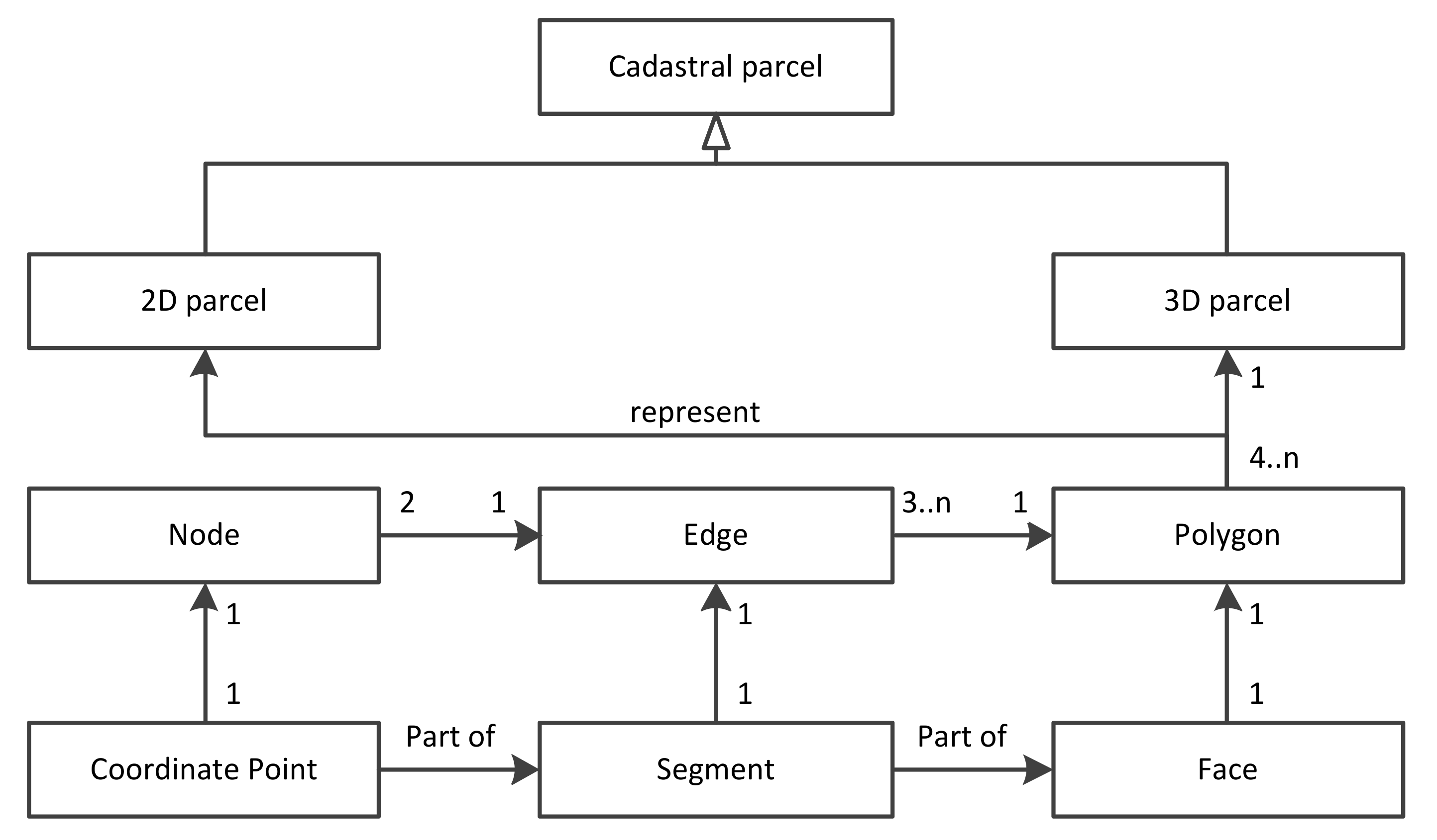
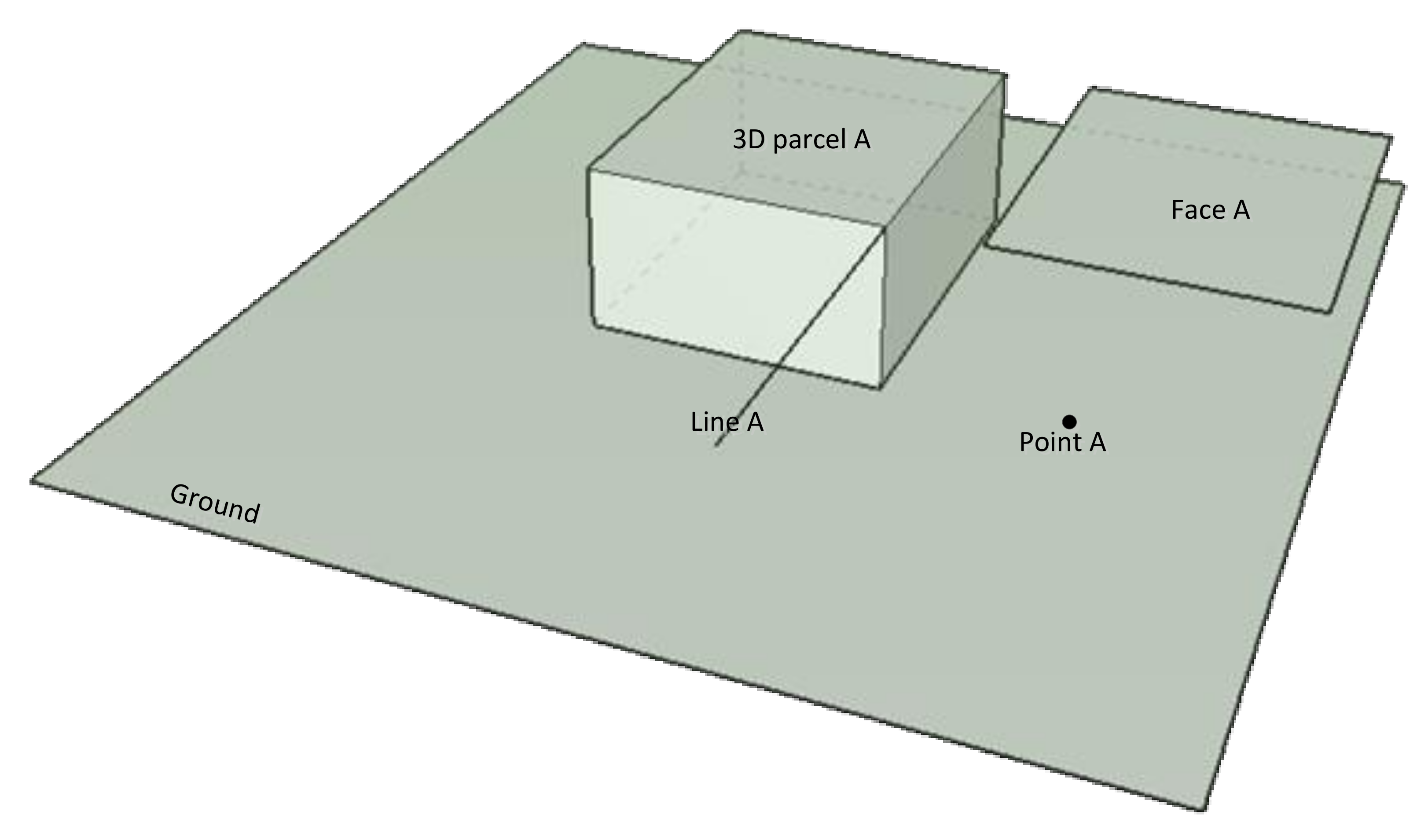
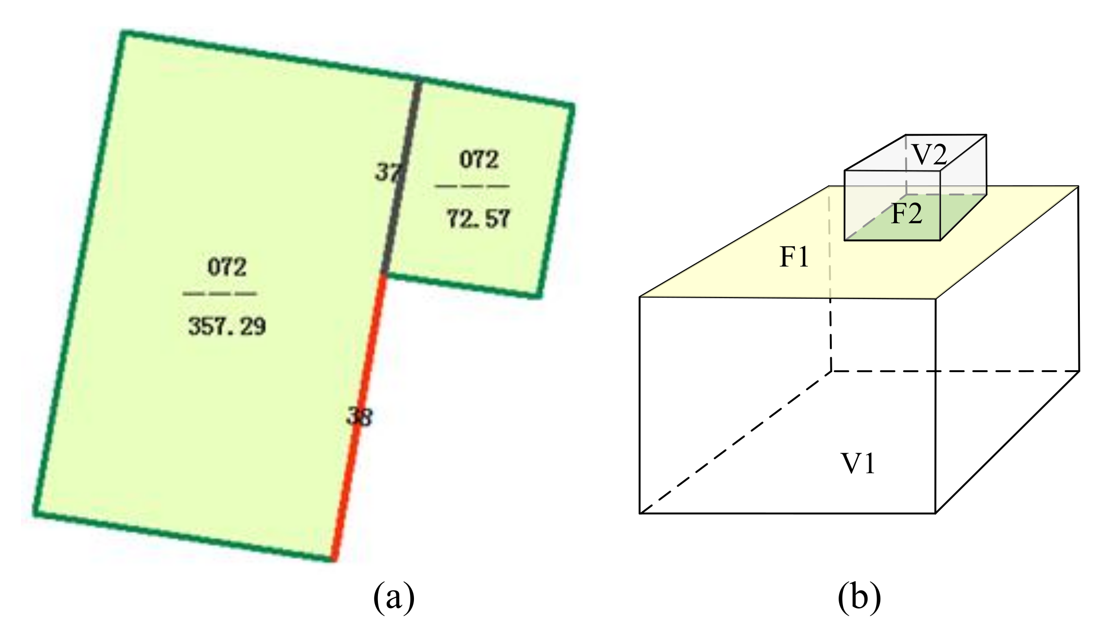
2. Characteristics of 3-D Cadastral Data
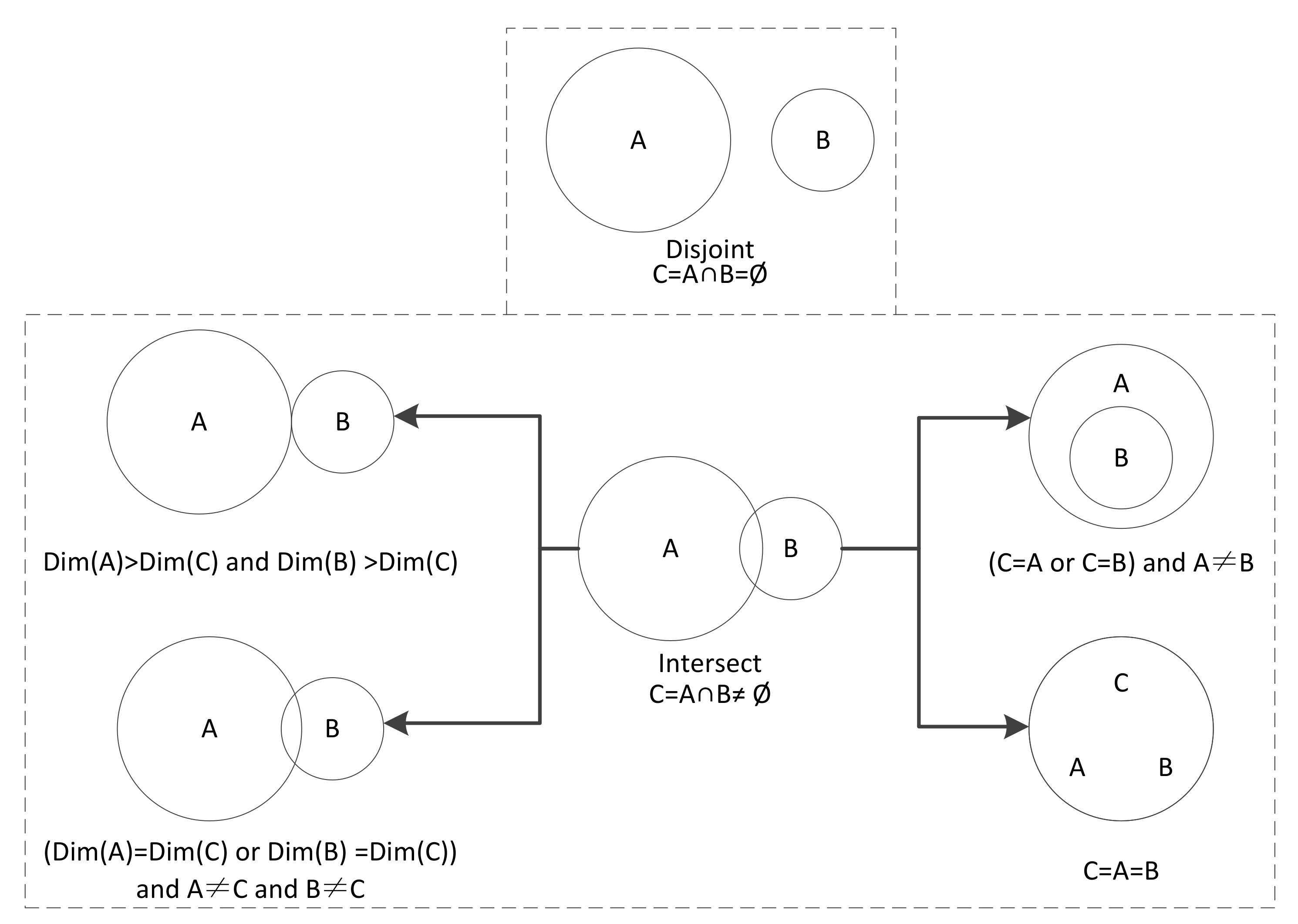
3. Topological Relations in 3-D Spaces
4. Classification of 3-D Cadastral Topological Relations
5. Discussion
6. Conclusions
Acknowledgments
Author Contributions
Conflicts of Interest
References
- Guo, R.Z.; Ying, S.; Li, L. Automatic Construction of 3-D Valid Solids for 3-D Cadastral Objects Based on Facet Sets. Acta Geod. Cartogr. Sin. 2012, 41, 620–626. [Google Scholar]
- He, B.; Li, L.; Guo, R.Z.; Shi, Y. 3-D Topological Reconstruction of Heterogeneous Buildings Considering Exterior Topology. Geomat. Inf. Sci. Wuhan Univ. 2011, 36, 579–583. [Google Scholar]
- Li, L.; Zhao, Z.G.; Guo, R.; He, B. 3-D Topological Construction for Spatial Physical Object. Geomat. Inf. Sci. Wuhan Univ. 2012, 37, 719–723. [Google Scholar]
- Shi, Y.F.; He, B. Research and Implementation of a Three Dimensional Cadastral Spatial Topology Data Model. Sci. Surv. Mapp. 2013, 38, 12–14. [Google Scholar]
- Shi, Y.F.; Zhang, L.L.; He, B. A 3-D Cadastral Space Consolidation and Segmentation Algorithm Based on a Topological Data Model. Sci. Surv. Mapp. 2013, 38, 106–109. [Google Scholar]
- Egenhofer, M.; Franzosa, R.D. Point-set topological spatial relations. Int. J. Geogr. Inf. Syst. 1991, 5, 161–174. [Google Scholar] [CrossRef]
- Chen, J.; Li, C.; Li, Z.; Gold, C. A Voronoi-based nine-intersection model for spatial relations. Int. J. Geogr. Inf. Sci. 2001, 15, 201–220. [Google Scholar] [CrossRef]
- Deng, M.; Zhang, X.S.; Lin, Z.J. Modeling Topological Relations Based on Euler Characteristics. Geomat. Inf. Sci. Wuhan Univ. 2004, 29, 872–876. [Google Scholar]
- Guo, W.; Chen, J. The formal description of topological spatial relationship in 3-D based on point set topology. Acta Geod. Cartogr. Sin. 1997, 26, 122–127. [Google Scholar]
- Randell, D.; Cui, Z.; Cohn, A. A spatial logic based on regions and connection. In Proceedings of the 3rd International Conference on Principles of Knowledge Representation and Reasoning, Cambridge, MA, USA, 23–25 October 1992; pp. 165–176. [Google Scholar]
- Gao, L.X.; Zhao, B.; Liu, W. RCC Topological Relations between Vague Regions Based on Rough Sets. Geogr. Geo-Inf. Sci. 2008, 24, 16–19. [Google Scholar]
- Yu, Q.Y.; Liu, D.Y.; Liu, Y.B. An Expanded Egg-Yolk Model between Intermediate Regions. Acta Electron. Sin. 2004, 32, 610–615. [Google Scholar]
- Zhou, X.G.; Chen, J.; Jiang, J.; Zhu, J. Description of topological relationships between cadastral landforms. Acta Geod. Cartogr. Sin. 2003, 32, 356–361. [Google Scholar]
- Zhou, X.G.; Yue, G.S.; Wei, J.Z.; Zhao, R.L.; Zhu, J.J. A Computation Method of Parcels’ Topological Relations Based on Oracle Spatial. J. Cent. South Univ. (Sci. Technol.) 2005, 36, 317–322. [Google Scholar]
- Xu, Z.H.; Bian, F.L. Cadastral Spatial Entities and Their Spatiotemporal Topological Relations. Geomat. Inf. Sci. Wuhan Univ. 2002, 27, 522–527. [Google Scholar]
- Ye, J. Research on Cadastral Dynamic Management Technology Based on Spatial Object Relationship Analysis; Zhejiang University: Hangzhou, China, 2006. [Google Scholar]
- Zhou, X.; Chen, J.; Li, Z. Calculation of Topological Relations Based on Euler numbers. Acta Geod. Cartogr. Sin. 2006, 35, 291–298. [Google Scholar]
- Shi, Y. Study on a 3-D Cadastral Spatial Data Model and Its Key Techniques; Wuhan University: Wuhan, China, 2009. [Google Scholar]
- ISO TC211. ISO 19152 Geographic Information—Land Administration Domain Model (LADM); ISO: Geneva, Switzerland, 2012. [Google Scholar]
- Ying, S.; Guo, R.; Li, L. 3-D Cadasters; Science Press: Beijing, China, 2014. [Google Scholar]
- Van Oosterom, P.J.M.; Stoter, J.E.; Ploeger, H.D.; Thompson, R.J.; Karki, S. World-wide inventory of the status of 3-D cadasters in 2010 and expectations for 2014. In Proceedings of the 3-D-Cadasters at the FIG Working Week, Marrakech, Morocco, 18–22 May 2011. [Google Scholar]
- Aien, A.; Kalantari, M.; Rajabifard, A.; Williamson, I.; Bennett, R. Advanced principles of 3-D cadastral data modeling. In Proceedings of the 2nd International Workshop on 3-D Cadasters, Delft, The Netherlands, 16–18 November 2011. [Google Scholar]
- Stoter, J.; Ploeger, H. Property in 3-D—Registration of multiple use of space: Current practice in Holland and the need for a 3-D cadaster. Comput. Environ. Urban Syst. 2003, 27, 553–570. [Google Scholar] [CrossRef]
- Paulsson, J. Reasons for introducing 3-D property in a legal system—Illustratedby the Swedish case. Land Use Policy 2013, 33, 195–203. [Google Scholar] [CrossRef]
- Paulsson, J.; Paasch, J.M. 3-D property research from a legal perspective. Comput. Environ. Urban Syst. 2013, 40, 7–13. [Google Scholar] [CrossRef]
- Ho, S.; Rajabifard, A.; Stoter, J.; Kalantari, M. Legal barriers to 3-D cadaster implementation: What is the issue? Land Use Policy 2013, 35, 379–387. [Google Scholar] [CrossRef]
- Karki, S.; Thompson, R.; McDougall, K.; Cumerford, N.; Van Oosterom, P.J.M. ISO Land Administration Domain Model and LandXML in the Development of Digital Survey Plan Lodgement for 3-D Cadaster in Australia. In Proceedings of the 2nd International Workshop on 3-D Cadasters, Delft, The Netherlands, 16–18 November 2011. [Google Scholar]
- Aiena, A.; Kalantaria, M.; Rajabifard, A.; Williamson, I.; Bennett, R. Utilising data modelling to understand the structure of 3-D cadasters. J. Spat. Sci. 2013, 58, 215–234. [Google Scholar] [CrossRef]
- Shojaei, D.; Olfat, H.; Faundez, S.I.Q.; Kalantari, M.; Rajabifard, A.; Briffa, M. Geometrical data validation in 3-D digital cadaster—A case study for Victoria, Australia. Land Use Policy 2017, 68, 638–648. [Google Scholar] [CrossRef]
- Egenhofer, M.; Herring, J. Categorizing Binary Topological Relations between Regions, Lines, and Points in Geographic Databases; Technical Report; Department of Surveying Engineering, University of Maine: Orono, ME, USA, 1991. [Google Scholar]
- Clementini, E.; Felice, P.D.; Oosterom, P.V. A small set of formal topological relationships suitable for end-user interaction. In Proceedings of the Advances in Spatial Data-Third International Symposium (SSD’93), Singapore, 23–25 June 1993, 2nd ed.; Abel, D., Ooi, B.C., Eds.; Lecture Notes in Computer Science; Springer: Berlin, Germany, 1993; Volume 62, pp. 277–295. [Google Scholar]
- Zlatanova, S. 3-D GIS for Urban Development; ITC: Enschede, The Netherlands, 2000. [Google Scholar]
- Zhang, J.; Qin, X.; Bao, L. Method for simplifying 3-D spatial nine-intersection model. J. Nanjing Univ. Aeronaut. Astronaut. 2006, 38, 335–340. [Google Scholar]


| Point | Segment | Face | Solid | |
|---|---|---|---|---|
| Point | disjoint/equal | disjoint/touch | disjoint/touch | disjoint/touch |
| Segment | disjoint/touch | disjoint/equal | disjoint/touch | disjoint/touch |
| Face | disjoint/touch | disjoint/touch | disjoint/equal | disjoint/touch |
| Solid | disjoint/touch | disjoint/touch | disjoint/touch | disjoint/equal |
| Type | Example |
|---|---|
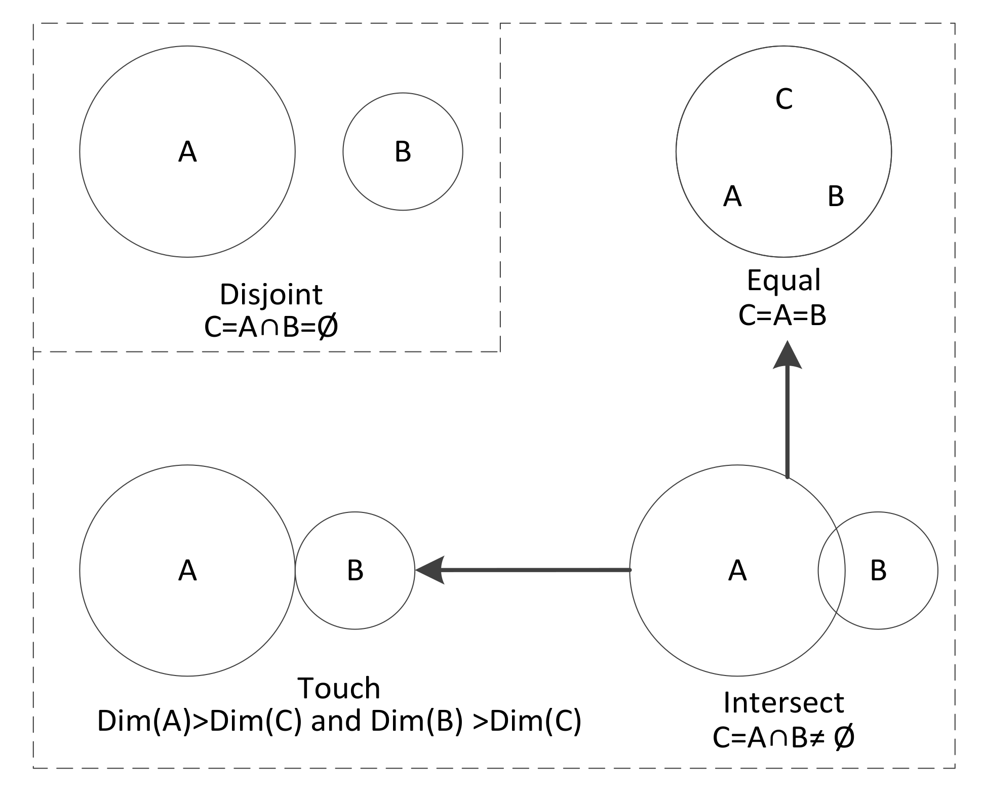
| LFD | 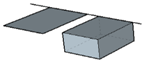 |
| NLFD |  |
| LNFD | 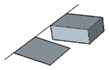 |
| NLNFD |  |
| Type | Example |
|---|---|
| PLFT |  |
| PNLFT |  |
| PLNFT |  |
| PNLNFT | 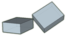 |
| LFT |  |
| LNFT | 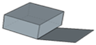 |
| FT | 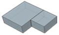 |
| Disjoint | Point | Segment | Face | Solid |
|---|---|---|---|---|
| Point | D | LFD/NLFD | LFD/NLFD/NLNFD | LFD/NLFD/NLNFD |
| Segment | LFD/NLFD | LFD/NLFD/NLNFD | LFD/NLFD/NLNFD | LFD/NLFD/NLNFD |
| Face | LFD/NLFD/NLNFD | LFD/NLFD/NLNFD | LFD/NLFD/LNFD/NLNFD | LFD/NLFD/LNFD/NLNFD |
| Solid | LFD/NLFD/NLNFD | LFD/NLFD/NLNFD | LFD/NLFD/LNFD/NLNFD | LFD/NLFD/LNFD/NLNFD |
| Touch | Point | Segment | Face | Solid |
|---|---|---|---|---|
| Point | - | PT | PT | PT |
| Segment | PT | PLFT/PNLFT | PLFT/PNLFT/PNLNFT | PLFT/PNLFT/PNLNFT |
| Face | PT | PLFT/PNLFT/PNLNFT | PLFT/PNLFT/PLNFT/PNLNFT/LFT/LNFT | PLFT/PNLFT/PLNFT/PNLNFT/LFT/LNFT |
| Solid | PT | PLFT/PNLFT/PNLNFT | PLFT/PNLFT/PLNFT/PNLNFT/LFT/LNFT | PLFT/PNLFT/PLNFT/PNLNFT/LFT/LNFT/FT |
© 2018 by the authors. Licensee MDPI, Basel, Switzerland. This article is an open access article distributed under the terms and conditions of the Creative Commons Attribution (CC BY) license (http://creativecommons.org/licenses/by/4.0/).
Share and Cite
Fu, L.; Yin, P.; Li, G.; Shi, Z.; Liu, Y.; Zhang, J. Characteristics and Classification of Topological Spatial Relations in 3-D Cadasters. Information 2018, 9, 71. https://doi.org/10.3390/info9040071
Fu L, Yin P, Li G, Shi Z, Liu Y, Zhang J. Characteristics and Classification of Topological Spatial Relations in 3-D Cadasters. Information. 2018; 9(4):71. https://doi.org/10.3390/info9040071
Chicago/Turabian StyleFu, Lili, Pengcheng Yin, Gang Li, Zhifeng Shi, Youzhi Liu, and Jiyi Zhang. 2018. "Characteristics and Classification of Topological Spatial Relations in 3-D Cadasters" Information 9, no. 4: 71. https://doi.org/10.3390/info9040071
APA StyleFu, L., Yin, P., Li, G., Shi, Z., Liu, Y., & Zhang, J. (2018). Characteristics and Classification of Topological Spatial Relations in 3-D Cadasters. Information, 9(4), 71. https://doi.org/10.3390/info9040071