Virtual Globes: Serving Science and Society

 ,
, 

Abstract
:1. Introduction: GIS and GIScience
2. Virtual Globes
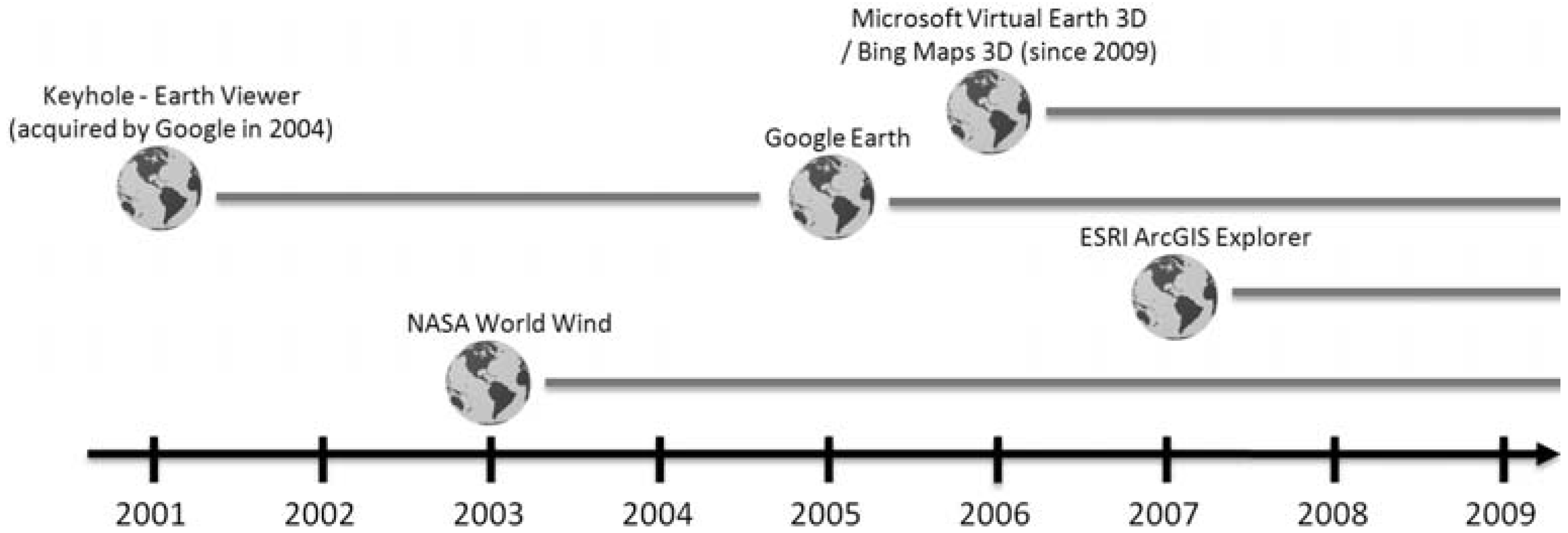
2.1. Technical Developments and Standards
2.2. Booming Applications
2.3. The Vision of “Digital Earth”
2.4. “Doing Geography” with Virtual Globes
- (i) The science of GIS, concerning the analysis of the fundamental issues raised by the use of GIS.
- (ii) GIS as tool making, involving the advancement of the tool's capability and ease of use.
- (iii) GIS as a tool, involving the use of a particular class of software, associated hardware tools, and digital geographic data in order to advance some specific purpose.
2.5. Socializing Virtual Globes
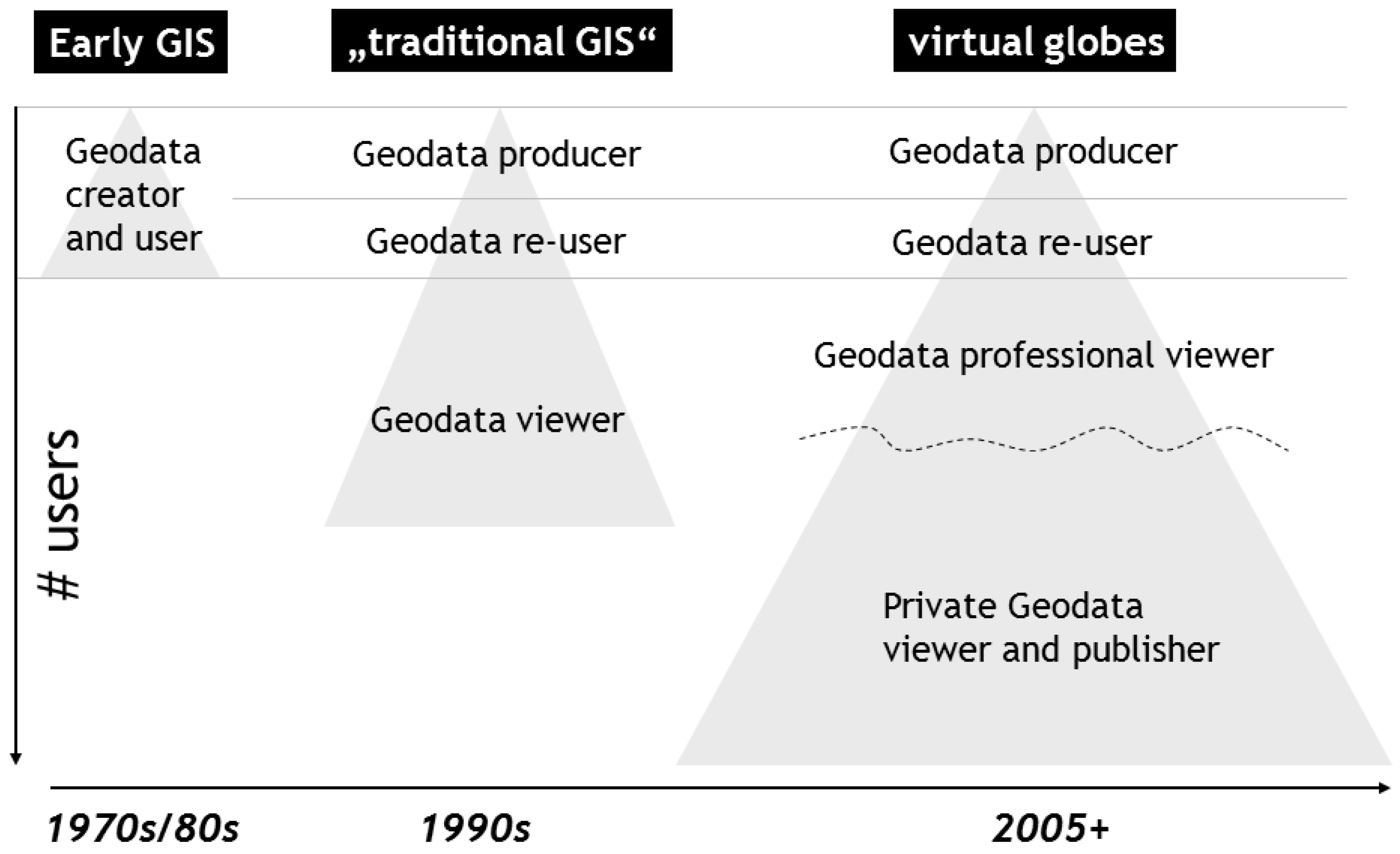
2.6. Widening the User Base—Democratizing GIS?
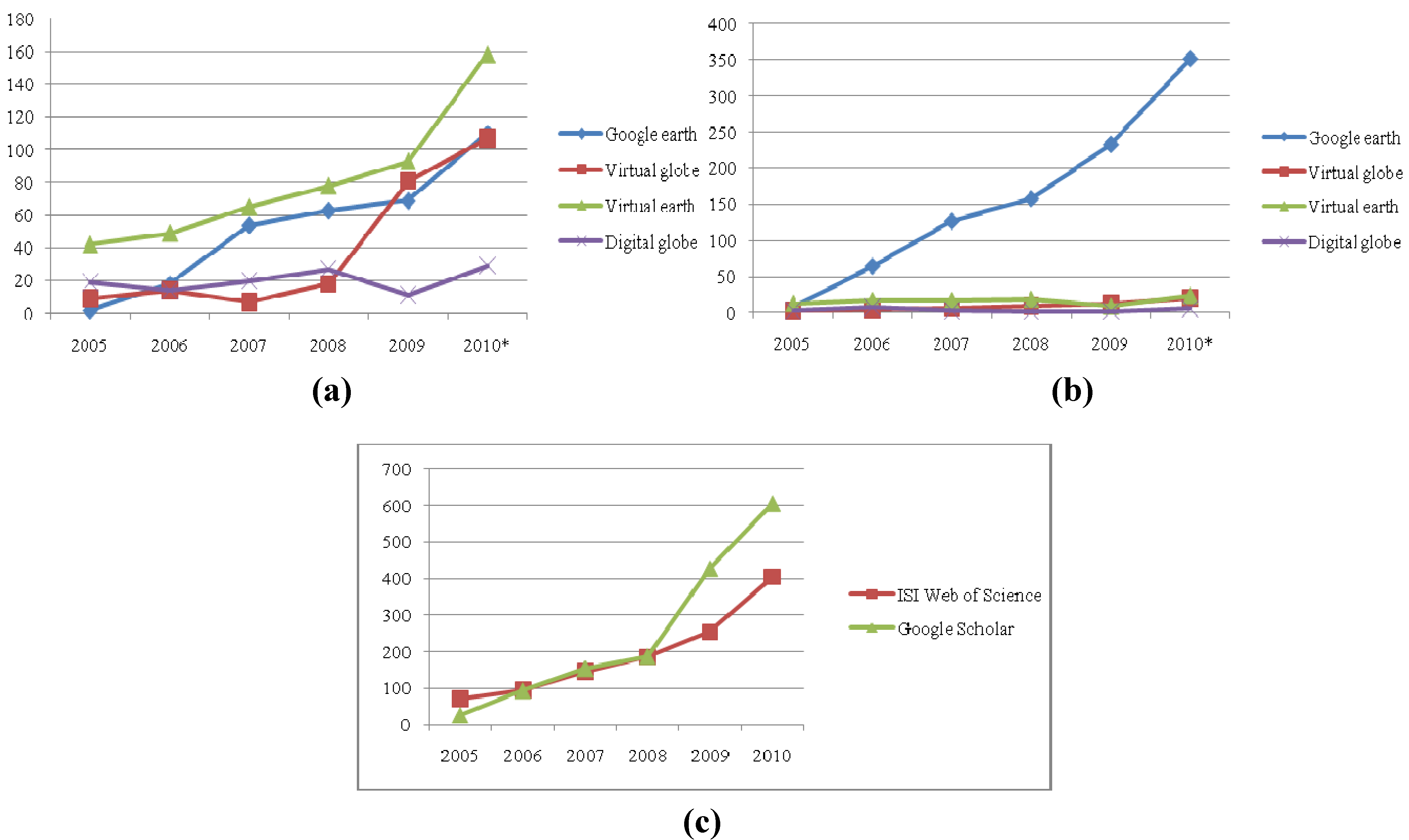
2.7. Heterogeneous Terminology: An Empirical Study

| (a) Total number of publications. | ||||||||
| ISI Web of Science | Google Scholar | |||||||
| Publication Year | Google earth | Virtual globe | Virtual earth | Digital globe | Google earth | Virtual globe | Virtual earth | Digital globe |
| 2005 | 0.6 | 3.8 | 8.7 | 15.8 | 0.8 | 5.3 | 13.1 | 12.7 |
| 2006 | 5.7 | 5.9 | 10.1 | 11.6 | 6.9 | 7.1 | 17.2 | 33.9 |
| 2007 | 17.1 | 3.0 | 13.4 | 16.6 | 13.5 | 12.5 | 17.2 | 12.7 |
| 2008 | 19.9 | 7.6 | 16.1 | 22.5 | 16.8 | 16.0 | 19.2 | 8.5 |
| 2009 | 21.8 | 34.4 | 19.2 | 9.2 | 24.7 | 23.1 | 9.1 | 8.5 |
| 2010 | 34.9 | 45.3 | 32.6 | 24.3 | 37.3 | 35.9 | 24.2 | 23.7 |
| Total | 100.0 | 100.0 | 100.0 | 100.0 | 100.0 | 100.0 | 100.0 | 100.0 |
| (b) Total publications. | ||||||||
| Publication Year | ISI Web of Science | Google Scholar | ||||||
| 2005 | 72 | 27 | ||||||
| 2006 | 95 | 94 | ||||||
| 2007 | 146 | 154 | ||||||
| 2008 | 186 | 188 | ||||||
| 2009 | 254 | 428 | ||||||
| 2010 | 396 | 606 | ||||||
| Total | 1158 | 1497 | ||||||

3. Bias on “The Mappable”?
3.1. Some Critique
3.2. Digital Earth and Neogeography
4. Conclusions
4.1. Virtual Globes: Educating the Masses?
4.2. Positioning and Privacy
4.3. Towards a GISociety
References
- Longley, P.A.; Godchild, M.F.; Maguire, D.J.; Rhind, D.W. Geographic Information Systems and Science, 3rd ed; John Wiley & Sons: Chichester, UK, 2001. [Google Scholar]
- Scholten, H.J.; van de Velde, R.; van Manen, N. Geospatial Technology and the Role of Location in Science; Springer: Dordrecht, The Netherlands, 2009. [Google Scholar]
- Corrigan, J. Qualitative GIS and Emergent Semantics. In The Spatial Humanities: GIS and the Future of Humanities Scholarship; Bodenhamer, D.J., Corrigan, J., Harris, T.M., Eds.; Indiana University Press: Bloomington, IN, USA, 2010. [Google Scholar]
- Strobl, J. GI Science and technology-where next? GIS Dev. 2005, 9, 40–43. [Google Scholar]
- Sui, D.Z.; Goodchild, M.F. A tetradic analysis of GIS and society using McLuhan’s law of media. Can. Geogr. 2003, 47, 5–17. [Google Scholar] [CrossRef]
- Blaschke, T. Geographische informationssysteme: Vom werkzeug zur methode. Geogr. Z. 2003, 2, 95–114. [Google Scholar]
- Goodchild, M.F. Commentary: Whither VGI? GeoJournal 2008, 72, 239–244. [Google Scholar] [CrossRef]
- Elwood, S. Volunteered geographic information: Future research directions motivated by critical, participatory, and feminist GIS. GeoJournal 2008, 72, 173–183. [Google Scholar] [CrossRef]
- Sui, D.Z. The wikification of GIS and its consequences: Or Angelina Jolie’s new tattoo and the future of GIS. Comput. Environ. Urban Syst. 2008, 32, 1–5. [Google Scholar]
- Blaschke, T.; Strobl, J. Geographic information science developments. GIS. Sci. 2010, 23, 9–15. [Google Scholar]
- Foody, G.M. GIS: Stressing the geographical. Prog. Phys. Geogr. 2004, 28, 152–158. [Google Scholar] [CrossRef]
- Goodchild, M.F. The validity and usefulness of laws in geographic information science and geography. Ann. Assoc. Am. Geogr. 2004, 94, 300–303. [Google Scholar] [CrossRef]
- Coleman, D.J. The potential and early limitations of volunteered geographic information. Geomatica 2010, 64, 209–219. [Google Scholar]
- Goodchild, M.F. GIScience, geography, form, and process. Ann. Assoc. Am. Geogr. 2004, 94, 709–714. [Google Scholar]
- Butler, D. Virtual globes: The web-wide world. Nature 2006, 439, 776–778. [Google Scholar] [CrossRef]
- Craglia, M.; Goodchild, M. F.; Annoni, A.; Camara, G.; Gould, M.; Kuhn, W.; Mark, D.; Masser, I.; Maguire, D.; Liang, S.; et al. Next-generation digital earth: A position paper from the vespucci initiative for the advancement of geographic information science. Int. J. Spat. Data Infrastruct. Res. 2008, 3, 146–167. [Google Scholar]
- McLead, B. Mass-market Geo: Emerging trends and standards. In Presented at the CEOS WGISS-22 conference, Annapolis, MD, USA, 12 September 2006.
- Open Geospatial Consortium Homepage. KML (Keyhole Markup Language), Making Location Count. Available online: http://www.opengeospatial.org/standards/kml/ (accessed on 26 November 2010).
- Open Geospatial Consortium Homepage. OGC White Paper. Interoperability and open architectures: An analysis of existing standardisation processes and procedures. Available online: http://www.opengeospatial.org/pressroom/papers (accessed on 15 July 2010).
- Kiehle, C.; Greve, K.; Heier, C. Requirements for next generation spatial data Infrastructures-standardized web based geoprocessing and web service orchestration. Trans. GIS 2007, 11, 819–834. [Google Scholar]
- Glennon, A. Comments on naive geography, part 2, 2006. Available online: http://geography2.blogspot.com/2006/06/comments-on-naive-geography-part-2.html (accessed on 2 December 2010).
- News from Google—Google Homepage. Introducing Google Earth 5.0, 2009. Available online: http://www.google.com/intl/en/press/pressrel/20090202earthocean.html (accessed on 26 October 2010).
- Grossner, K.E.; Goodchild, M.F.; Clarke, K.C. Defining a digital earth system. Trans.GIS 2008, 12, 145–160. [Google Scholar] [CrossRef]
- Elmes, G.; Weiner, D.; D’alessandro-Scarpari, C. Digital earth. In International Encyclopedia of Human Geography; Kitchin, R., Thrift, N., Eds.; Elsevier: Oxford, UK, 2009; pp. 198–204. [Google Scholar]
- Kienberger, S.; Tiede, D. ArcGIS explorer review: Is this yet another virtual globe? GeoInformatics 2008, 11, 42–47. [Google Scholar]
- Goodchild, M.F. What does Google Earth mean for the spatial sciences? In Proceedings ofGIS Ireland Conference, Dublin, Ireland, October 13, 2005.
- Colwell, R. The new landscape of science: A geographic portal. Ann. Assoc. Am. Geogr. 2004, 94, 703–708. [Google Scholar]
- Wright, D.J.; Goodchild, M.F.; Proctor, J.D. Demystifying the persistent ambiguity of GIS as “Tool” versus “Science”. Ann. Assoc. Am. Geogr. 1997, 87, 346–362. [Google Scholar] [CrossRef]
- Tiede, D.; Lang, S. Analytical 3D views and virtual globes—scientific results in a familiar spatial context. Int. J. Photogramm. Remote Sens. 2010, 65, 300–307. [Google Scholar] [CrossRef]
- Turner, A.J. Introduction to Neogeography; O’Reilly Press: Sebastopol, CA, USA, 2006. [Google Scholar]
- Harris, T.M.; Rouse, L.J.; Bergeron, S. The geospatial semantic web, pareto GIS, and the humanities. In The Spatial Humanities: GIS and the Future of Humanities Scholarship; Bodenhamer, D.J., Corrigan, J., Harris, T.M., Eds.; Indiana University Press: Bloomington, IN, USA, 2010; pp. 124–142. [Google Scholar]
- Kraak, J.M. Why maps matter in GIScience. Cartogr. J. 2003, 43, 82–89. [Google Scholar] [CrossRef]
- Obermeyer, N.J. GIS: The maturation of a profession. Cartogr. Geogr. Inf. Sci. 2007, 34, 129–132. [Google Scholar] [CrossRef]
- Barrotta, G.; Cipriano, P.; Pezzi, S.; Zanella, L. Where would you go for mapping services, [NMAs] or Google Maps? Implementing “hackable” user-driven GI services within SDIs. In ESDI: From Inspiration to Implementation, 12th EC and EC GIS Workshop, Innsbruck, Austria, 21–23 June 2006; Fullerton, K., Toth, K., Eds.;
- Onsrud, H.J.; Johnson, J.; Lopez, X. Protecting personal privacy in using geographic information systems. Photogramm. Eng. Remote Sens. 1994, 60, 1083–1095. [Google Scholar]
- Nouwt, S. Reasonable expectations of geo-privacy? SCRIPTed 2008, 5, 375–403. [Google Scholar] [CrossRef]
- Obermeyer, N.J.; Pinto, J.K. Managing Geographic Information Systems; The Guildford Press: New York, NY, USA, 1994. [Google Scholar]
- Taylor, P.J.; Johnston, R. GIS and geography. In Ground Truth; Pickles, J., Ed.; The Guilford Press: New York, NY, USA, 1995; pp. 68–87. [Google Scholar]
- Schultz, R.B.; Kerski, J.J.; Patterson, T.C. The use of virtual globes as a spatial teaching tool with suggestions for metadata standards. J. Geogr. 2008, 107, 27–34. [Google Scholar]
- Elwood, S. Geographic information science: New geovisualization technologies—emerging questions and linkages with GIScience research. Prog. Hum. Geogr. 2009, 33, 256–263. [Google Scholar] [CrossRef]
- Peter, F.; Unwin, D.J. Re-presenting geographical information systems. In Re-Presenting GIS; Peter, F., Unwin, D.J., Eds.; John Wiley & Sons: Chichester, UK, 2005; pp. 1–17. [Google Scholar]
- Radcliffe, S.A. National maps, digitisation and neo-liberal cartographies: Transforming nation-state practices and symbols in postcolonial Ecuador. Trans. Inst. Br. Geogr. 2009, 34, 426–444. [Google Scholar] [CrossRef]
- Pickles, J. Representations in an electronic age: Geography, GIS and democracy. In Ground Truth. The Social Implications of Geographic Information Systems; Pickles, J., Ed.; The Guilford Press: New York, NY, USA, 1995; pp. 1–30. [Google Scholar]
- Ahlqvist, T. A quest for polygon landscapes, or GIS and the condition of epistemology. Fennia 2000, 178, 97–111. [Google Scholar]
- Schuurman, N. Trouble in the Heartland: GIS and its critics in the 1990s. Prog. Hum.Geogr. 2000, 24, 569–90. [Google Scholar] [CrossRef]
- O’Sullivan, D. Geographic information science: Critical GIS. Prog. Hum. Geogr. 2006, 30, 783–791. [Google Scholar] [CrossRef]
- Pavlovskaya, M. Theorizing with GIS: A tool for critical geographies? Environ. Plan. 2006, 38, 2003–2020. [Google Scholar] [CrossRef]
- Sieber, R. Public participation geographic information systems: A literature review and framework. Ann. Assoc. Am. Geogr. 2006, 96, 491–507. [Google Scholar] [CrossRef]
- Chainey, S.; Ratcliffe, J.H. GIS and Crime Mapping; John Wiley & Sons: Chichester, UK, 2005. [Google Scholar]
- Healy, D.J.; Stancioff, A. Development of a Geographic Information System in Support of Poverty Reduction, No. 7113660; World Bank: Montpelier, VT, USA, 2002. [Google Scholar]
- PPgis.net—Open Forum on Participatory Geographic Information Systems and Technologies Homepage. Available online: http://ppgis.iapad.org (accessed on 3 December 2010).
- Steinmann, R.; Krek, A.; Blaschke, T. Can online map-based applications improve citizen participation? In E-Government: Towards Electronic Democracy; Böhlen, M., Gamper, J., Polasek, W., Eds.; Springer: Berlin, Germany, 2005; pp. 25–35. [Google Scholar]
- Caron, C.; Roche, S.; Goyer, D.; Jaton, A. GIScience journals ranking and evaluation: An international delphi study. Trans. GIS 2008, 12, 293–321. [Google Scholar] [CrossRef]
- Harvey, F. More than names—digital earth and/or virtual globes? Int. J. Spat. Data Infrastruct. Res. 2009, 4, 111–116. [Google Scholar]
- Scharl, A. Towards the geospatial web: Media platforms for managing geotagged knowledge repositories. In The Geospatial Web: How Geobrowsers, Social Software and the Web2.0 are Shaping the Network Society; Scharl, A., Tochtermann, K., Eds.; Springer: London, UK, 2007; pp. 3–14. [Google Scholar]
- Hakley, M.; Singelton, A.; Parker, C. Web mapping 2.0: The neogeography of the GeoWeb. Geogr. Compass 2008, 2, 2011–2039. [Google Scholar]
- Crutcher, M.; Zook, M. Placemarks and waterlines: Racialized cyberscapes in post-Katrina Google Earth. Geoforum 2009, 40, 523–534. [Google Scholar] [CrossRef]
- De Longueville, B. Community-based geoportals: The next generation? Concepts and methods for the geospatial Web 2.0. Comput. Environ. Urban Syst. 2010, 34, 299–308. [Google Scholar] [CrossRef]
- Mayall, K.; Hall, G.B. Landscape grammar 1: Spatial grammar theory and landscape planning. Environ. Plan. B Plan. Des. 2005, 32, 895–920. [Google Scholar]
- Pickles, J. Tool or science? GIS, technoscience and the theoretical turn. Ann. Assoc. Am. Geogr. 1997, 87, 363–372. [Google Scholar] [CrossRef]
- Aitken, S.C. Public participation, technological discourses and the scale of GIS. In Community Participation and Geographic Information Systems; Craig, W., Harris, T., Weiner, D., Eds.; Taylor & Francis: London, UK, 2002; pp. 357–366. [Google Scholar]
- Schuurman, N. Formalization matters: Critical GIScience and ontology research. Ann. Assoc. Am. Geogr. 2006, 96, 726–739. [Google Scholar] [CrossRef]
- Schuurman, N. Critical GIS: Theorizing an emerging discipline. Cartographica 2001, 36, 1–108. [Google Scholar]
- Agarwal, P. Ontological considerations in GIScience. Int. J. Geogr. Inf. Sci. 2005, 19, 501–536. [Google Scholar] [CrossRef]
- MacEachren, A.M. Cartography and GIS: Facilitating collaboration. Prog. Hum. Geogr. 2000, 24, 445–456. [Google Scholar] [CrossRef]
- Sheppard, S.R.J. The ethics of Google Earth: Crossing thresholds from spatial data to landscape visualization. J. Environ. Manag. 2009, 90, 2102–2117. [Google Scholar] [CrossRef]
- Jones, M.T. Google’s geospatial organizing principle. IEEE Comput. Graph. Appl. 2007, 27, 8–13. [Google Scholar] [CrossRef]
- Sui, D.Z. Terrae incognitae and limits of computation: Whither GIScience? Comput. Environ. Urban Syst. 2001, 25, 529–533. [Google Scholar] [CrossRef]
- Warf, B.; Arias, S. Introduction: the reinsertion of space into the social sciences and humanities. In The Spatial Turn. Interdisciplinary Perspectives; Warf, B., Arias, S., Eds.; Routledge: Abingdon, Oxford, UK, 2009; pp. 1–10. [Google Scholar]
- Hudson-Smith, A.; Crooks, A.; Gibin, M.; Milton, R.; Batty, M. NeoGeography and Web 2.0: Concepts, tools and applications. J. Locat. Based Serv. 2009, 3, 118–145. [Google Scholar] [CrossRef]
- Wood, D. The Power of Maps; The Guilford Press: New York, NY, USA, 1992. [Google Scholar]
- Crampton, J.W.; Krygier, J. An introduction to critical cartography. ACME Int. E-J. Crit. Geogr 2006, 4, 11–33. [Google Scholar]
- Slocum, T.A.; Egbert, S.L. Cartographic data display. In Geographic Information Systems: The Microcomputer and Modern Cartography; Taylor, D.R.F., Ed.; Pergamon Press: Oxford, UK, 1991; pp. 167–199. [Google Scholar]
- Boonstra, O.W.A. No place in history—Geo-ICT and historical science. In Geospatial Technology and the Role of Location in Science; Scholten, H.J., van de Velde, R., van Manen, N., Eds.; Springer: Dordrecht, The Netherlands, 2009; pp. 87–101. [Google Scholar]
- Goodchild, M.F.; Janelle, D.G. Toward critical spatial thinking in the social sciences and humanities. GeoJournal 2009, 75, 2–13. [Google Scholar]
- Warf, B.; Arias, S. Introduction: the reinsertion of space into the social sciences and humanities. In The Spatial Turn. Interdisciplinary Perspectives; Warf, B., Arias, S., Eds.; Routledge: Abingdon, Oxford, UK, 2009; pp. 1–10. [Google Scholar]
- Weiser, M. The computer for the twenty-first century. Sci. Am. 1991, 9, 94–104. [Google Scholar] [CrossRef]
- Hilty, L.; Behrendt, S.; Binswanger, M.; Bruinink, A.; Erdmann, L.; Fröhlich, J.; Köhler, A.; Kuster, N.; Som, C.; Würtenberger, F. The Precautionary Principle in the Information Society. Effects of Pervasive Computing on Health and Environment, TA-SWISS, TA 46e/2005; Report of the Centre for Technology Assessment (TA-SWISS): Bern, Switzerland, February 2005.
- Gewin, V. Mapping opportunities. Nature 2005, 427, 376–377. [Google Scholar]
- Lever, J.A. Unintended consequences of the global positioning system. Syst. Eng. 2004, 7, 217–228. [Google Scholar]
- Beresford, A.R.; Stajano, F. Location privacy in pervasive computing. Pervasive Comput. 2003, 1, 46–55. [Google Scholar]
- Torrens, P.M. Geography and computational social science. GeoJournal 2010, 75, 133–148. [Google Scholar]
- Dobson, J.; Fisher, P. Geoslavery. IEEE Technol. Soc. Mag. 2003, 22, 47–52. [Google Scholar] [CrossRef]
- Armstrong, M.P.; Ruggles, A.J. Geographic information technologies and personal privacy. Cartographica 2005, 40, 63–73. [Google Scholar] [CrossRef]
- Virrantaus, K.; Fairbain, D.; Kraak, M.J. ICA research agenda on geography and geographic information science. Cartographica 2009, 44, 45–55. [Google Scholar]
- Ren, F.; Kwan, M.P. The impact of the Internet on human activity-travel patterns: Analysis of gender differences using multi-group structural equation models. J. Transp. Geogr. 2009, 17, 440–450. [Google Scholar]
- Taylor, P.J. GKS. Polit. Sci. Q. 1999, 9, 211–212. [Google Scholar]
- Rouse, L.J.; Bergeron, S.J.; Harris, T.M. Participating in the Geospatial Web: Collaborative mapping, social networks and participatory GIS. In The Geospatial Web. How Geobrowsers, Social Software and the Web2.0 are Shaping the Network Society; Scharl, A., Tochtermann, K., Eds.; Springer: Berlin, Germany, 2007; pp. 153–158. [Google Scholar]
- Fischer, F. We are excited about maps—they are excited about maps! Tele Atlas feeds and makes use of neogeographers. GeoInformatics 2008, 7, 10–13. [Google Scholar]
- McGee, M. Nicaragua Raids Costa Rica, Blames Google Maps, 2010. Available online: http://searchengineland.com/nicaragua-raids-costa-rica-blames-google-maps-54885 (accessed on 3 December 2010).
© 2012 by the authors; licensee MDPI, Basel, Switzerland. This article is an open-access article distributed under the terms and conditions of the Creative Commons Attribution license (http://creativecommons.org/licenses/by/3.0/).
Share and Cite
Blaschke, T.; Donert, K.; Gossette, F.; Kienberger, S.; Marani, M.; Qureshi, S.; Tiede, D. Virtual Globes: Serving Science and Society. Information 2012, 3, 372-390. https://doi.org/10.3390/info3030372
Blaschke T, Donert K, Gossette F, Kienberger S, Marani M, Qureshi S, Tiede D. Virtual Globes: Serving Science and Society. Information. 2012; 3(3):372-390. https://doi.org/10.3390/info3030372
Chicago/Turabian StyleBlaschke, Thomas, Karl Donert, Frank Gossette, Stefan Kienberger, Martin Marani, Salman Qureshi, and Dirk Tiede. 2012. "Virtual Globes: Serving Science and Society" Information 3, no. 3: 372-390. https://doi.org/10.3390/info3030372
APA StyleBlaschke, T., Donert, K., Gossette, F., Kienberger, S., Marani, M., Qureshi, S., & Tiede, D. (2012). Virtual Globes: Serving Science and Society. Information, 3(3), 372-390. https://doi.org/10.3390/info3030372