Article

Linking Theories, Past Practices, and Archaeological Remains of Movement through Ontological Reasoning

1
CNRS/University of Bourgogne Franche-Comté–Chrono-Environnement/MSHE C.N. Ledoux, 25030 Besançon, France
2
Faculty of Humanities/CLUE+, Vrije Universiteit Amsterdam, 1081 HV Amsterdam, The Netherlands
3
Department of Computer Science, University of Montpellier2–IRD/Espace-Dev, 34093 Montpellier, France
4
Archaeology, University of Glasgow, Glasgow G12 8QQ, UK
5
CNRS/University of Tours—CITERES/MSH Val de Loire, 37020 Tours, France
*
Authors to whom correspondence should be addressed.
Information 2020, 11(6), 338; https://doi.org/10.3390/info11060338
Submission received: 10 May 2020 / Revised: 14 June 2020 / Accepted: 15 June 2020 / Published: 24 June 2020
(This article belongs to the Special Issue Digital Humanities)

Abstract

:
The amount of information available to archaeologists has grown dramatically during the last ten years. The rapid acquisition of observational data and creation of digital data has played a significant role in this “information explosion”. In this paper, we propose new methods for knowledge creation in studies of movement, designed for the present data-rich research context. Using three case studies, we analyze how researchers have identified, conceptualized, and linked the material traces describing various movement processes in a given region. Then, we explain how we construct ontologies that enable us to explicitly relate material elements, identified in the observed landscape, to the knowledge or theory that explains their role and relationships within the movement process. Combining formal pathway systems and informal movement systems through these three case studies, we argue that these systems are not hierarchically integrated, but rather intertwined. We introduce a new heuristic tool, the “track graph”, to record observed material features in a neutral form which can be employed to reconstruct the trajectories of journeys which follow different movement logics. Finally, we illustrate how the breakdown of implicit conceptual references into explicit, logical chains of reasoning, describing basic entities and their relationships, allows the use of these constituent elements to reconstruct, analyze, and compare movement practices from the bottom up.

1. Introduction

Over the past two decades, the basis for the creation of archaeological knowledge about past societies archaeology has fundamentally changed. This shift has been driven by multiple factors, notably the acceleration of development-led archaeology [1,2,3] and the integration of large digital observational datasets, particularly those acquired through remote sensing methods for earth observation and monitoring [4,5], the proliferation of scientific methods applied to gather diverse data [6], and the increasing digitization of archaeological data [3,7,8].
Within these broader trends, emerging applications of machine learning methods for the identification of features of archaeological interest in remote sensing derived datasets (e.g., [9,10]) are causing a particularly important change in knowledge production practices. The machine learning methods being applied in many archaeological remote sensing projects take as an input examples of features which represent different types of entities. For example, a project team studying field clearance as a practice might seek to provide examples to an algorithm of the “most important” types of features related to field clearance activities. The research team might provide examples of round cairns, linear cairns, irregular cairns, and field boundary walls, which based on their knowledge at the time were the most relevant feature types. The algorithm learns to identify features similar to these input examples, and when applied it does so quickly and at an extensive scale. This method, in multiplying the identified examples of features of a type similar to the examples used as inputs, rapidly reinforces the dominance of those types of features in the archaeological record. An unintended consequence of this process is that features which were not considered important when designing the machine learning project could be further marginalized within the archaeological record, as the existing state of knowledge of the project team and their research biases are reproduced and reinforced at an unprecedented scale. This problem of “circular reasoning” and “finding more of what you expect to find”, posed by the strong reinforcement through machine learning of implicit ideas and knowledge about what physical features represent different activities and processes, has been noted by researchers working in this domain [11,12,13], particularly in the context of the transfer of these algorithms between different environmental or archaeological contexts.
Two key sources which inform the implicit ideas and knowledge base of teams working in this context are the domain-specific literature on the activity or process they aim to study, as well as prior identifications in remote sensing data by expert interpreters of features related to that activity or process. To address part of this problem of strong reinforcement of implicit knowledge, we propose an approach to integrating a re-reading of the rich but challenging written archive of archaeological research on a given topic with the existing information structures used in expert identifications of features in remote sensing data sources, focusing on extensive aerial data sources such as those derived from satellite imagery, aerial photography, and airborne laser scanning (lidar). To illustrate this approach, we explore the process of creating archaeological knowledge about past movement and the material evidence of its impact on the landscape.
Using three case studies drawn from the archaeological research literature (primarily journal articles and books), we analyze how researchers have identified and conceptualized the material traces of various movement processes in different regions. Although the case studies are very different in their descriptive vocabularies and the physical remains they discuss, our analysis shows that all of them combine formal pathway systems, characterized by infrastructure intentionally devoted to enabling travel and movement, and informal movement systems, characterized by diverse features and structures which are co-opted to enable movement. As these two systems are not hierarchically integrated but rather intertwined, we propose to introduce a new concept, the “track graph” that aims to record observed material features in the most neutral form possible, providing a basis for analyzing the combined systems. Of a purely analytical nature, this abstract “track graph” concept can be employed to reconstruct trajectories that follow various types of movement logic.
We outline our approach to constructing ontologies, in this paper’s example built around the “track graph”, through which we explicitly relate material elements identified in observational data from remote sensing or field-based surveys to a body of knowledge or theory as expressed in the written research, in this paper’s example about movement. Movement is a particularly useful topic through which to explore our proposed approach because as a concept it integrates diverse practices, manifested archaeologically through varied physical forms, and it has been approached in quite different ways by researchers working in different contexts. It presents the kind of intellectual complexity, shared by many topics salient to contemporary research on archaeological landscapes, which requires us to grapple with core issues of knowledge creation.

2. Biases Affecting the Corpus of Physical Features Used as Evidence of Movement

As we noted above, there are two key sources which inform new identifications of features as evidence of past movement: domain literature and past expert identifications in observational datasets (remote sensing) or field observations. Each of these are affected by inter-related methodological, observational, contextual, and semantic biases. These biases are well known, as they impact on most observational datasets created and used by archaeologists, and we summarize the key impacts for studies of movement here.
Methodological biases: The choice of remote sensing technique and the design of the survey affect the probability of detecting features, depending on their specific physical characteristics. Some techniques are better for observing features on the ground surface and others for detecting features below the surface. Some are more suitable for detecting smaller features, while others will only reveal features under specific conditions of lighting, soil humidity, or vegetation cover [14,15]. Survey design choices related to areal coverage and spatial resolution have significant effects on detection probabilities [15,16].
Observational biases: Observers tend to recognize features similar to those they have seen before [11], so an observer’s familiarity with features has a significant impact on the frequency of recognition (see, e.g., [12]). Observational bias may lead to false positives as well as false negatives.
Contextual biases: Some features are easily identified and interpreted in isolation, because they have an unequivocal physical expression that cannot be mistaken for something else. However, in most cases we need an understanding of a feature’s context in order to correctly identify it [17], taking into account environmental, cultural, and historical context [18]. Certain environmental conditions will enhance or suppress the physical expression of some features, e.g., because they are easily eroded, leading to potential misidentifications. Equally, if contextual information about the known activities in a region at different periods is lacking or incorrectly interpreted, the identification of features may be erroneous [19], a situation complicated by the changing use of physical features over time [20].
Semantic biases: The assignment of a feature to a specific class or type may be a source of disagreement between observers, since the two observers may draw on different classifications and typological systems. Further, even when notionally working within the same system, these two observers might rely on different implicit ideas about the character or function of a feature belonging to each class, using the same term to indicate and imply different things, further complicating the effects of this bias [21]. This problem is only increased when communicating across languages, and it is the basis of many problems associated with cross-linking datasets. Even if we know that crêtes de labour in French are translated as headlands in English, are we sure that these are really the same thing? Do other observers understand these terms in the same way? Further complicating matters, the meaning of these terms can change over time as the research context evolves [19].

2.1. Focusing on Observational Biases: How to Recognize a Path

When looking for material and physical traces of movement, both in the field or in the “digital terrain” created from aerial and satellite remote sensing data, all these biases are at play. Our eyes will follow linear features that we immediately “translate” as roads, trails, or trackways. In the field, we can walk along a stretch of an unconstructed path, describing its changing shape, drawing associations with artefacts or features nearby, and recognizing when it merges with the built environment, for example as a causeway. When this walked segment is recognized on digital imagery or terrain models, a process in itself affected by methodological and observational biases, its field-based description is then implicitly extended to the whole linear form observed from the aerial point of view.
This field-based description and its direct aerial-view correlate become the knowledge model used to recognize morphologically similar features in aerial imagery and terrain models as paths. Through this process, particularly when accelerated through machine learning applications, the generalization of field observations through extensive remote sensing datasets will reinforce existing ideas. This interpretive practice does not lend itself to insights into different systems of movement which do not align with our field experience, which is itself embedded in received ideas of what physical features related to movement should look like, ideas developed and reproduced through the literature and affected by semantic and contextual biases. In sum, through our practices of engaging with the literature, field observation, lidar-derived digital terrain models (LDTMs), and complementary remote sensing datasets, we have enhanced our ability to see more of what we already know.
The impact of these inter-related biases can be seen in projects that have generated spatially extensive but semantically narrow datasets. For example, projects working in Central America have identified extensive evidence for major Maya causeways, usually called sakbeh (white, constructed roads) [22]. This type of road is well known from the fieldwork, and its connection to the major cities of the Mayan world is well established [23,24], with key exemplars of the type well mapped and recognized as part of a network. Integration of this existing knowledge base with new observational data from lidar provided an extensive overview of this causeway system [25]. The knowledge gained from the lidar data, however, is only relevant to the major transport network defined by these features. It does not extend our knowledge of different types of movement in this landscape and the traces these might leave.
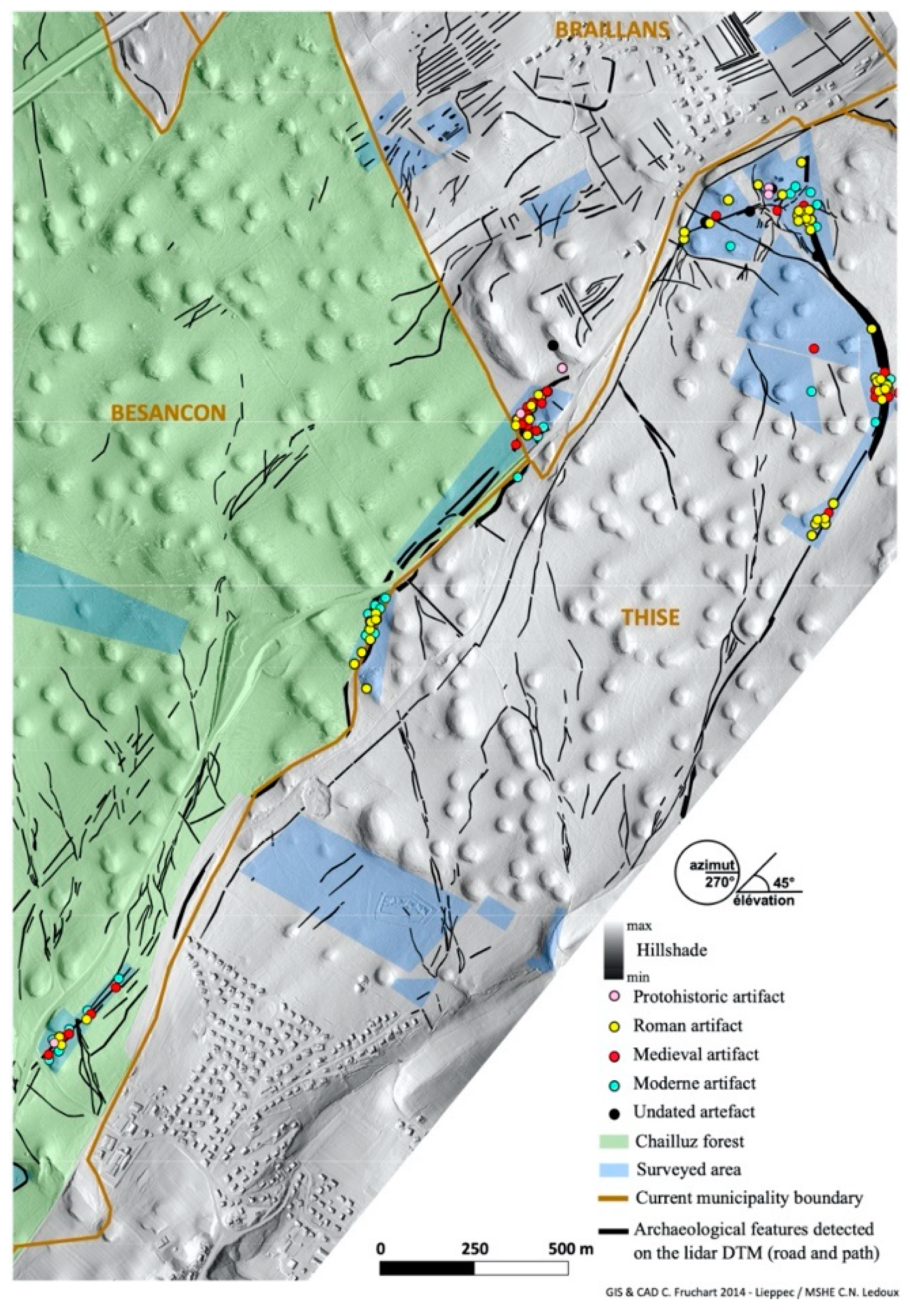
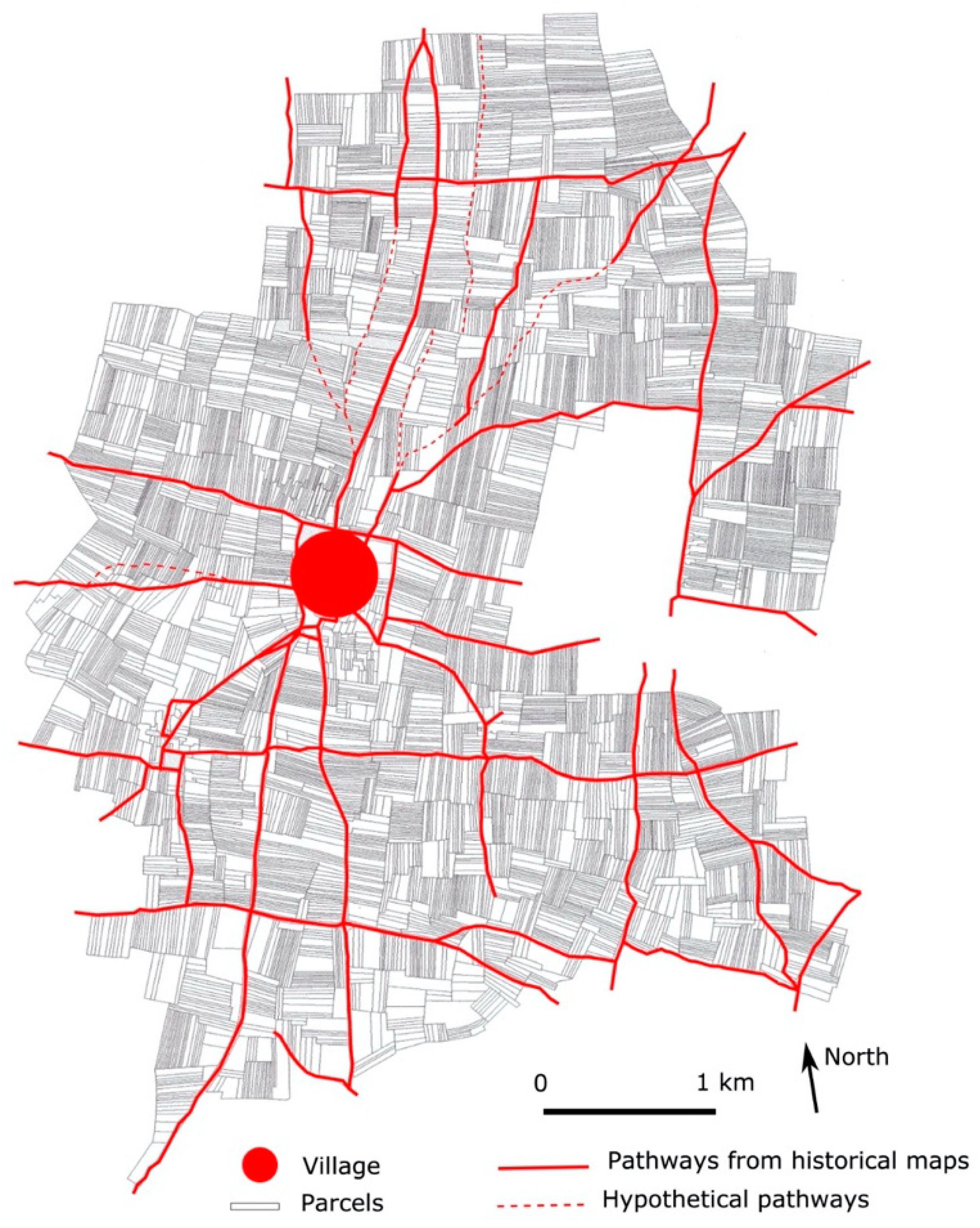
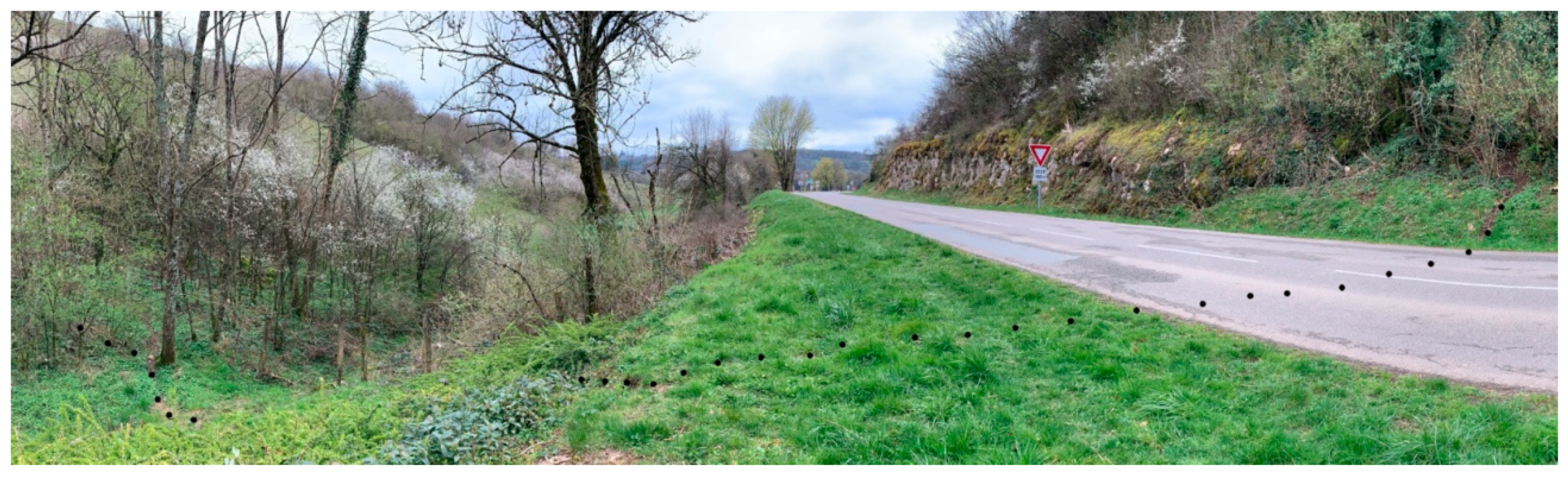
In another context, in eastern France, we encounter a similar situation. Thousands of features related to paths can be identified in the LDTM, based on ideas of paths drawn from fieldwork and literature. In this area, the physical manifestations of paths appear as a tangle, often lacking clear endpoints because they are only partly preserved or visible in the LDTM (Figure 1). While we know the location and parts of the course of many more paths as the result of this digital survey work, insight into different types of movement and interconnections between different networks of features that make up this tangle remain elusive, as the impacts of methodological and observational biases result in an incomplete picture.
Beyond the methodological and observational biases that impact our knowledge creation practices when drawing on observational data, we face semantic and contextual biases when developing data models, typologies, and classification systems, as we seek to organize and make sense out of the tangle of features identified and sought in the observational data. While some methodological biases can be accounted for in a straightforward way, for example, data resolution will have an easy to understand impact on our ability to recognize features smaller than a certain size, semantic biases can be more challenging to assess and understand.

2.2. Focusing on Semantic Biases: What Words to Use to Describe A Path

While reading many papers addressing the subject of movement we observed that archaeologists, whatever their field of expertise, employ various words to describe pathways, such as path, trail, road, corridor, causeway-canal, or causeway. The terminology adopted, however, is almost never substantiated and this use of implicit definitions makes comparisons between case studies or their integration difficult.
For example, in a cross-cultural Franco-English study the use of implicit definitions is particularly problematic because some terms which are used as translational matches are not true semantic equivalents. The word “chemin” in French is semantically equivalent to the English word “trail”, whereas “sentier” would be more like “path”. However, the English word “path” is usually directly translated into “chemin” creating a strong ambiguity. Beyond these problems of semantic mistranslation, depending on the socio-cultural context, the terms chosen may imply other meanings beyond that related to movement. The term beh in the Yucatec Maya language is a good example of this situation. According to Keller [22], it has both a literal and metaphorical meaning. It implies the idea of displacement in space but also in calendar time. It also implies the idea of work done and/or completed, as well as the ideas of life course, prosperity, and destiny. These additional meanings pose further problems for translation to a different cultural context.
In 2009, to address this problem of terminology, Timothy Earle [27] suggested a working typology to study paths, trails, and roads within a comparative perspective in order to examine their distribution and function. In his approach, Earle considers paths as “local trodden ways” with an “essentially individual” function, associated with daily tasks and with a low investment in their construction. A path is by nature ephemeral and “largely unrecognizable” in ploughed fields, for example. Paths are associated with local scale “household movements” and with logistical activities and daily use. Trails are more permanent routes “marked by repeated use, by signs such as blazes, cairns, and petroglyphs, and on maps”. Contrary to paths, trails are “regional or long-distance routes”. Their function is logistical and ceremonial and therefore “trail use is both individual and group oriented”. Finally, roads are constructed routes which need labor investment and “chiefdom and state” political integration to be planned. Roads “formalize movement” and their functions are ceremonial and military. They are mostly regional in scale, with segments of long-distance routes sometimes also serving as local routes.
A close reading of this typology raises several problems. Earle, himself, recognized many of them and concluded that through his typology the “examination of variation in routes of movement shows the alternative ways that societies operate and change under contrasting sociopolitical and environmental conditions”, and that the static model was not entirely satisfactory. He suggested, “that routine methods should be developed to describe and analyze them [routes of movement]” which would allow for greater diversity to be taken into account“, and that the analysis of variation in routes “offers great insight into the essence of human societies and their evolution”. Reviewing the difficulties posed by Earle’s typology in detail provides a useful mechanism for highlighting broader issues of semantic bias.
Earle’s typology implies that under the same very generic terms we will find a set of material and physical traces that are morphologically relatively homogeneous. However, in both his own study and more broadly, we contend that field observations provide a more complex picture from the outset, and the distinction between road and path is not always clear. For example, Hyslop [28] reminds us that for the Inka world the same route can vary from a formally constructed road to a simple path over only a few kilometers. The same type of observation about the variable physical form of a road was made regarding “Caesar’s Causeway” in France during excavations carried out along its route [29].
His typology also illustrates the implicit links that can arise between typologies and models of social structures. Earle’s typology is embedded in a strong model of social hierarchy which associates forms of movement infrastructure with stratified levels of social complexity. A level of social and political organization is attached to each term and its associated set of morphological evidence, as is a specific geographical scale that determines the structure of the traffic system. Therefore, the definition of a physical feature using one of these terms implicitly gives it the particular function and status associated with that term. This association between a term, function, and status is a common semantic bias problem. By associating morphological entities with specific functions, scales, and social hierarchy levels which are all associated with a single word, we reduce our ability to grasp the social complexity of movement.
Even with full knowledge of the complications and nuance implicit in the words used in the definition of any class or type, and when only using a working typology or informal schema, these problems are present. Further, in a classification system with single, fixed semantic categories, wherein a route can only be classified as a road and not as both a road and a path, the infrastructure created through and enabling movement is thought of as single-purpose, rather than as involved in several movement-related activities. The use of systems or working typologies that assign features to a single class or single type might be appropriate for discussing the components of an idealized communication network that has been planned and organized into hierarchical levels. However, they are less effective for describing the structure that supports the movement processes of individuals or groups of individuals as they renegotiate their journeys depending on their activities, social rules and technical capabilities, and on the landscape’s opportunities to move around [30,31]. For example, in applying Earle’s working typology, which assigns features to single classes, a team might assign all the diverse constituent features which are recombined ad hoc to form diverse types of paths and are associated with multiple types of movement to the a single class of “path”, and in doing this they implicitly reinforce a hierarchical view of systems of movement.
When considering change over time, the assignment to single categories is again problematic because a simple path can become a road and conversely a road can “degenerate” into a path due to lack of maintenance or change of purpose [32]. Returning to the embeddedness of typologies in general models of social structures, we note that behind the distinction between road and path there is usually an evolutionary conception of the world and an implied equation of growth and increase in size or material consumption with progress, with roads being associated with a certain, increased degree of societal complexity [33]. Therefore, as soon as we order the material evidence into classes of pathways, we implicitly include a hierarchy in their function as well as in their spatial and temporal scale. Through these various mechanisms, the act of assigning features to classes as part of the interpretive process and the selection of a specific set of classes to which features can be assigned tends to reinforce broader implicit ideas about how processes and activities in the past took place and delimits the realm of possible understandings of the character of the past societies and landscapes in question.

3. Things, Words, and Concepts: Methodology

How can we qualify the material and physical traces observed and identified as potentially used for displacement without getting lost in a descriptive typology that compartmentalizes complex reasoning into tidy morphologically homogeneous sets? How can we deal with the “variation of itineraries” based on a set of morphologically heterogeneous material traces, while at the same time giving them meaning? How can we integrate this variation into our approach to identifying and interpreting observational data so as not to reduce our field of knowledge to what we already know how to recognize? Finally, how can we demonstrate the relationships we identify between these observations of heterogeneous material traces, themselves subject to the biases discussed above, and the whole of our archaeological, historical, anthropological and theoretical knowledge?
Attempting to respond to these questions, our approach involves focusing on properties in terms of physical topographic characteristics and basic functions (e.g., depression, alignment, embankment), rather than directly applying the terminology of higher order categories (e.g., hollow ways) and culturally specific categories of objects (e.g., sakbeh in the Maya world: Elevated causeways linking temples, ceremonial centers, or cities). By decomposing the broad concept of “movement” as it is used in archaeology [31,34,35,36] into more specific constituent concepts and by building explicit links to interpretations of how these concepts are expressed in observational data, we aim to develop a common conceptual framework, the so-called “track graph”. This common framework can be used to design and connect various explicit chains of inference related to the analysis of pathways and past movement flows.

3.1. The Implications of the Semiotic Triangle for Our Approach

We have seen that the diversity of observed features which enable movement leads either to a multiplication of descriptive terms or to a narrowing of approved terminology, motivated by a classificatory or typological approach. In the first case, the use of overly specific terms makes it difficult to identify connections between entities that effectively serve the same role in systems of movement, while in the second case features with similar morphologies may be grouped together, creating false connections between entities that represent different kinds of movement. In both cases, it is difficult to compare different case studies or even different systems of movement within the same case study.
In order to avoid these dead ends, we have relied on the semiotic triangle designed by C.K. Ogden and I.A. Richards [37]. For these authors, who worked on language, the misunderstanding between two people who use the same term lies in the fact that we often confuse the name (symbol) of an object and this object (referent) itself (the base of the triangle in Figure 2). Starting from the principle that the meaning of a word is determined by the lived experience of the speaker, they reject any idea of canonical or standardized meaning. This is why, in order to clarify the relationship usually implicitly established between a word and an object, they define what they called the domain of reference or thought (the top vertex of the triangle). The field of reference is what we refer to as a concept, that is to say, the body of empirical and theoretical knowledge that allows us to conceive what a thing is—in our case, a material or physical entity dedicated to movement—and to link it to a word that designates and defines it as such—in our case, the terminology associated with pathways in general. Thus, for example, in the Pueblo world, the material traces of a staircase observed carved into a cliff, of deep ruts, and of scattered ceramics on a line, could all be grouped together under the same term “regional trail”. In the same way, the material traces of a staircase observed carved into a cliff could be associated with the term “trail” and the term “place” [38]. Therefore, it is the relationship with the concept, or field of reference, that will give meaning to the identification of a material or physical entity as a road, for example.
Based on this theory, our approach therefore consists of analyzing the way in which material characteristics identified in the observed world (terrain, imagery, LDTM, etc.) are related to terms connected to the process of movement (trail, path, road, trackways, holloways, causeways, canals, riverpaths, roads, local trodden pathways, etc.). Our goal is to develop a framework for describing and linking practices of movement, topographic morphology and other material evidence, and the historical and environmental contexts of pathways and their trajectories. This framework should include all the key elements of the domain and explain their relationships in order to reconstruct one or several logical assemblages that constitute a pathway, an intersection, or even a network or a meshwork [31].

3.2. An Ontological Approach to Structuring and Formalizing the Description

In analyzing cross-cultural case studies developed by different research teams, we adopt an ontological approach to address the issue of ambiguity identified above (Figure 3). This has several advantages. First, it provides a structured, formal way of describing and relating the various terms and knowledge bases used. It also clarifies the structure of the available knowledge. Second, it allows us to consider the various relationships between the terms and concepts used: Hierarchical, topological, temporal, and spatial. In this way, we can create the metadata needed to describe and access meaningful information on movement, and strive towards interoperability, as defined under the FAIR principles [13].
In practice, when developing their own study, a research community or group describes their chosen question about past movement using terms and ideas drawn from several published studies. The published studies serve as sources from which the research group can assemble a broad “world” of context-specific concepts used to address a single, more global, idea. These concepts are then organized, with the aim of connecting what was observed, which we think of as things, or nouns, with how we understand the activities that produce them, which we think of as verbs. To create an operational model of these conceptual domains, we proceeded in three steps: Analyzing articles for the language used to describe landscape features and actions of movement, producing a graph model of the language used, and formalizing this into an ontology. By drawing together and studying the language used in multiple case studies, we attempt to define a conceptual model that is implicitly broadly shared by the research community interested in the question, but which does not rely on a predefined model. Rather, domain and question specific ontological models are developed ad hoc to address specific research agendas.
While we do not seek to encourage the mechanization of the interpretation process, our approach relies on the formalization of concepts and alignment with shared community standards for describing knowledge domains. Therefore, we also make use of existing conceptual reference models such as the CIDOC CRM [39,40], which we aim to cross-map with our ontology’s domain-specific entities and properties. This mapping to a shared community standard (currently in progress) aims to increase the usefulness of the specialized domain ontology, as it could be made interoperable with related systems which also make use of the CIDOC CRM.
We underline the creativity, discussion, and reflection emergent through the practice of creating these domain ontologies, which enables us to better understand and map the limitations and potential of our knowledge. In short, the practice of ontology creation and mapping is a heuristic tool that can help us in the process of interpretation. Importantly, the resulting ontology provides a formal framework that can be used to share data which remains flexible, and may be adapted by other research projects to their own contexts.
This heuristic aspect of the ontological approach is particularly useful for the development of a cross-cultural analytical framework. The linking of concepts drawn from the literature on different areas allows a research group to identify points of commonality and differences between concepts of movement as discussed in diverse regions. The way concepts are linked provides a common definition for assemblages of various morphological, temporal, spatial, and functional characteristics, which are not necessarily the same across different geographical areas or even within the whole of the geographic area where they appear.
Formalizing these mappings into a UML schema to visually represent the structure of the knowledge domain precedes further formalization within an ontology editor (such as Protégé: https://protegewiki.stanford.edu/wiki/Main_Page). Using a logical language such as OWL (https://www.w3.org/2001/sw/wiki/OWL) allows for the visualization of concept hierarchies and the development of correspondences with other conceptual references, such as the CIDOC CRM.
To illustrate our approach, we present three case studies from the literature for which we modeled the domain of movement concepts as a UML schema represented as a graph (produced with software such as yEd; https://www.yworks.com/products/yed). Clearly the definitions of the concepts and their relationships may be debated, and it is these points of convergence and divergence of our views on these concepts and relationships relating to movement which become the basis for further study and debate.

4. Three Case Studies

The analysis of three cross-cultural case studies, used to illustrate our approach, are based on five papers treating regions in Mesoamerica (Caracol, Belize: [24,25]), South America (Bolivian Amazon: [41,42]), and north-western Europe (Beauce, France: [43]) (Figure 4). All three case studies have recorded material and physical traces linked to movement processes using various sensors and protocols (lidar, remote sensing imagery, field work, historical maps and documents, as well as ethnographic testimony) (Table A1).
In the case of Caracol, we engage with a territory characterized by a readily identified network of built causeways to enable travel between centers, but where the means of mobility from isolated residences (household groups) is less apparent and does not seem to be associated with extensive built features or terrain modifications. The relationship explored here, between sets of features which enable movement between centers, creating connections at a regional scale, and those operating locally, is also explored through the other two case studies which focus on the pre-Columbian period in Bolivia and the Medieval period in north-western Europe. The aim is not a direct comparison of these case studies, but rather to observe in each one how a formal communication network can be articulated with the patterns of movement developed by the population through everyday repetitive activities across the landscape. How do people move over the landscape to join residential centers and resource areas, or to carry out agricultural practices? How do formal road networks influence these daily trajectories? How does the articulation between these two systems produce a structure that imprints its mark on the landscape and influences channels of movement?

4.1. Caracol Region (Belize)

In Caracol, numerous pathways were discovered through the analysis of the lidar-derived DTM. The resulting collection of new causeway segments adds to the dataset compiled from previous observations during fieldwork and from satellite imagery based surveys [24]. The lidar based study revealed a large part of the main road system linking the major epicenter of Caracol to other places, called termini, understood as secondary centers which may be residential [25]. The LDTM shows a largely continuous swath of settlement and terracing that exists between the epicenter and these termini. This extensive urbanized landscape area is characterized by small groups of houses organized around small squares, which are integrated into the agrarian landscape, a pattern recognized in other Mayan regions. These settlement units are not directly connected to the epicenter or to the secondary centers by causeways [44]. The density of these areas remains relatively low, estimated at 4 to 10 units per hectare after the lidar survey [26]. This low density and lack of causeway or road infrastructure creates the impression that each small residential group (so-called household groups, or plazuela groups), while forming part of the urban fabric, is relatively isolated from the region’s most important residential centers. However, it is plausible that features within the agricultural field system provided strong connecting links between these dwellings and the main residential centers [44]. These are referred to in the Caracol case study as vias: “more informal and shortest roads” [24] which connected household groups to major causeways or joined “important residential groups directly with various non-residential termini”. The authors note that in Caracol, “many causeways (…) are intermixed with agricultural terraces” and that the vias can be primarily identified through a detailed mapping of these terraces. While, “only a half-dozen instances of vias have been formally noted attaching to Caracol’s longer causeways,” they emphasize that, “detailed mapping of the terraces would undoubtedly turn up other examples” [24]. Since the identified vias appear to provide direct access to the major causeways, the authors suggest that these causeways were partly used for everyday purposes and to facilitate movement and communication of the household groups. This example illustrates how, behind the more obvious and formal network of causeways, there is a meshwork drawn through daily practices of household groups going into the fields, to residential centers, and to other locations. To do so, individuals used various types of features to enable their quotidian routes or trajectories, including formal causeway segments and agricultural terraces features such as narrow pathways. Angela H. Keller’s study of Yucatec Mayan language [22] highlights the use of a single root beh connecting terms for diverse types of paths and roads, supporting the argument that multiple physical types of routes were recognized by this community.
We suggest simplifying the description of the Caracol Mayan communication system in the following form (Figure 5), describing a limited, artificially self-contained system which would have operated within a larger settlement system. Each component of this landscape, described in the UML schema, is connected by a path “network” composed of very formal causeways called sakbehs and more informal paths called vias. Vias may be inter-mixed with agricultural terraces and may be connected to the path network through junctions with the major sakbehs. These causeways connect the epicenter’s residential group to other residential termini and in some cases through junctions to non-residential termini (reservoirs, agricultural terraces, or other features). The household groups have no clear position in this case study. It is not obvious how they are connected to their fields (agricultural terraces), to the path network and, by extension, to the residential groups (epicenter and termini), and to the non-residential places such as reservoirs. It is possible that they are connected to the main path network using vias and some part of the sakbeh causeways segments.

4.2. Baures and Llanos de Mojos (Bolivian Amazon)

In two chapters of the book “Landscapes of movement”, edited by Snead et al. [45], Clark L. Erickson and John H. Walker discuss two case studies in the Bolivian Amazon during the pre-Columbian period [41,42]. Both regions are characterized by a marshy savannah landscape that was topographically transformed over several generations. A major investment of labor was made in order to construct earthworks, not to prevent inundation but to create an expanded and productive wetland. A region composed of savannah, forest areas, and rivers was progressively settled by the Moxos (or Mojos) and transformed into an anthropogenic landscape with settlement mounds, raised fields (farming areas), canals and raised roads/causeways (Figure 6), reservoirs and fish weirs. This anthropogenic landscape is discussed within the model of “landesque capital” by the authors, who propose that this cultural landscape was, “created, used and maintained by small farming communities over hundreds of generations”.
People moved through this highly modified landscape either on foot on causeways or by canoe in canals. According to the authors, “because of the intentionality, design, monumentality, and engineering used in their construction, causeways and canals are classified as formal roads rather than informal trails or paths” [42] in this context. The case study of the Baures region (N. Bolivia) also discusses a less formal system with shorter causeway-canals produced with minimal planning or labor, and “minor causeway-canals”. These shallow canals are interpreted by the authors as “pre-Columbian canoe paths”. They are produced by the “repeated paddling, poling, or dragging a large canoe” creating “canal-like depressions” over time. These shallow depressions are used as canoe paths during the wet season and as routes for pedestrian traffic during the dry season. These systems of major and minor causeway-canals appear to play complementary roles in the flow of goods and people over the savannah landscapes to join forested areas, rivers, settlement mounds, raised fields, resource locations, or other causeways “forming physical networks of local and regional scale”.
The schema below (Figure 6) represents the main concepts and relationships used by the authors to describe the complex movement systems of the Bolivian Amazon case studies. Their descriptions reveal two types of pathways, pedestrian and navigable, combined within the same system of movement. The production of pathways takes place through three types of processes. The planned building produced major causeway-canals. Minor causeway-canals were created through the wearing-in of shallow depressions in the earth through repeated journeys in canoes using techniques of paddling, polling, or dragging. These features were used as canoe paths or pedestrian paths seasonally. The building of earthen “bunds” created embankments for agricultural purposes, which were used opportunistically as pedestrian pathways. Referring to the concept of habitus in the sense introduced by Mauss [46] and later promoted by Bourdieu [47,48], the authors suggest that this pre-Columbian movement system was formed by intertwined processes of collective and individual actions, containing features both intentionally constructed and features generated through daily activities, rather than by a political entity’s planned projects. The material features connected to movement include diverse types of topographic features, supplementing the network of major causeways, joining settlements, farmed land, and other land use areas and features (forests, fishponds, etc.). The practices of movement by the population at a given period can be read through the assemblages of topographic elements created by that period’s activities. These are structured regionally around the main built routes (major causeway-canals), and locally in arrangements related to daily activities.

4.3. The Beauce Region (France)

In north-western Europe, in the Beauce region (France), an extensive settled agricultural landscape was maintained during the Medieval and Early Modern periods (12th–17th century AD), as discussed in detail in [13]. Based on the work of Samuel Leturcq [43], this study concentrated on the organization of the openfield landscape, specifically on the distribution of transportation routes across the agricultural areas. While historic maps revealed a dispersed local road network composed of “formal path roads” (Figure 7), in extensive continuous agricultural areas composed of a large number of contiguous small parcels with long strip shapes, no evidence of pathways is apparent which would provide a means for a peasant to reach plots of land enclosed within the field system. Written historical sources state that the borders of some fields can be used as paths by farmers to access their fields [43], providing a likely explanation for how they were reached. In this region, the practice of using field boundaries as paths is further evidenced by the term sommière, which is sometimes connected to the term for a path in the Medieval and Modern terrier, which is a register of lands belonging to a single landowner [43]. In England, in the written estate surveys and 16th-century Elizabethan maps of isolated farms and settlements of the All Souls College estate, the term “balk” is frequently used to refer to the grass access-way between two furlongs [49], a parallel concept.
This is what we defined as an “access path” in our schema (Figure 8). How were these “access paths” produced and by whom? What archaeological traces did they leave in the present landscape? And how can we identify them? In the dialect language of Toury en Beauce’s peasants, the terms sommière, sommier, or têtière refer to an “elevated portion of a field” located at the junction between two fields, otherwise called a headland ridge [50]. This topographic feature, potentially used as a pedestrian pathway by farmers, was not built to enable movement, but rather results from a specific ploughing technique employed in combination with particular social rules.
The schema above (Figure 8) summarizes the process of headland ridge production during the extended period in which farmers were using a style of turnplough or a plough-tail (a type of ard-plough) that is held at an angle while ploughing in order to push the earth to one side and then the other [51]. Rows were ploughed in straight lines, and the ploughs were turned at the boundaries of the strip field (“parcel” on the graph, Figure 8). As the land was tilled, the soil was moved and progressively accumulated on the edge of the field. Over the years, these accumulations of soil at the edge of each field developed into raised beds, or headlands, which can still be recognized in Beauce, and in many other regions [49,52,53,54] (Figure 9). The visible boundaries of the community’s cultivated lands are, consequently, materialized by the headland ridges. In cases where the direction of ploughing is regulated by the community, as is common in Medieval north-western Europe, the headland will gradually become a continuous border along numerous contiguous fields, creating connected field borders within a block of fields, or an “aggregate district” [55]. The accumulated evidence suggests that the headland-as-border developed into a structure that facilitated movement between fields and settlements including villages and isolated farms. While when fields were empty farmers could walk across the field, the headland was consistently available for use as a path, providing access when the fields contained growing crops or under other restrictive conditions defined by the village community, without having been intentionally created for this purpose. Even where we may lack textual evidence, we can infer that headland ridges likely supported the movement of farmers elsewhere, for example in England [49], when crossing fields would have been detrimental to crop growth.
Combining the formal road system mapped on historical documents with the headlands, we obtain a more complete picture of a flow of movement through the network of rural communities. It is only by bringing together the observational data created through the study of remote sensing data and maps and the knowledge of movement practices derived from the literature that we can start to fully map and understand the actual movement patterns. In our UML schema, the components representing physical features are linked by processes. For example, the farmer can access parcels using an “access path”. This could be either by headlands used as a pathway or by another, more formalized path such as a series of roads or routes depicted on a map.
In this case study, knowledge is structured in related classes in the UML schema, which allows us to connect important details, such as the workings of the turn plough, to a more general view of the landscape. Structuring knowledge and expressing it through this type of ontological description allows us to reconnect elements of an analysis to a body of knowledge and to transfer conceptual frameworks between case studies more easily. As a result of this exercise, what we called the “access path” is now better defined and this allows us to better model the local movement network of the farmers. We gain information on its morphology, its relation to social and landscape organization, and its use and temporality, linked to the rules of the agrarian community. The same ontology provides a framework for an informed interpretation of the results of either a visual interpretative survey or machine learning exercise. The abstract entity referred to as the “access path” enables us to integrate into a single functional term diverse physical structures which enable movement such as stairs, terraces, causeways, or minor causeway-canals.

4.4. Connecting Case Studies and Finding Commonalities

All the case studies presented here combine formal path systems and informal movement systems. They all illustrate a high degree of heterogeneity among the material and physical features related to movement through the landscape, e.g., built causeways, field boundaries, agricultural terraces, embankments, and formal and informal canals. Further, when there is no impetus or opportunity to construct a path, we see similarities in the way in which the landscape structures co-opted to enable movement are adapted and used. This ad hoc use of landscape features to move around the landscape creates a sort of “open-work fabric of interlaced or knotted cord”, or a meshwork [31] of informal paths. Sometimes these activities are regulated by the community, more or less explicitly, either by rules or repeated practices (habitus), and these repeated actions tend to progressively structure the mesh. This meshwork has a footprint in today’s tangible world, characterized by material and physical features that reflect the movements of a population in order to carry out tasks, to access particular spaces in the environment, and, especially in the cases discussed here, for agricultural activities.
In each case study, we observe a co-existence of two important motivations, or logics, for movement which use many of the same physical features in the landscape. The first is driven by the need to get from one place to another via an organized and socially recognized circulation network. This is what we refer to as “formal routes” which can be defined “as tangible, physical evidence of a route of travel serving as a means of communication between points or activity areas” [56]. Their morphology can generally be characterized, they are usually constructed to some degree, and they are maintained through a purposeful investment of labor such as cleaning and/or repairing the roadbed or repairing road curbs. This set of formal routes has generally left its imprint in the present tangible landscape and in documents, historical and cartographic, and in oral tradition through songs and narratives. This logic of movement using formal routes is conceptualized as a “path framework system”. This system can be materialized by a road, by a series of landscape markers, or by a narrative without associated physical features. It has contextual and temporal properties and it is consciously designed by a group of individuals, in other words by a society, which recognizes it.
The second is influenced primarily by the activities of individuals and motivated by a set of repeated practices, defined and progressively appropriated by a society as a whole (habitus). This set of movements also leaves an imprint in the current tangible landscape, but this imprint is composed of a heterogeneous set of material and physical features, which can vary according to the seasonal context, modes of displacement, or the tools used in the practice of an activity. This type of movement is more difficult to identify because it is not organized as a network with connected places but rather as a meshwork of intersecting routes [31]. Attempting to comprehend these trajectories through the meshwork requires us to mobilize our knowledge of social and economic practices, rules, norms, and customs. This knowledge, in turn, allows us to identify the imprint left in the landscape, especially its residual form in today’s tangible landscape and the potential arrangements for articulation with components of the formal route network. This second logic of movement is defined within our approach as the “pathway system”. Unlike the “path framework system”, the “pathway system” is unconsciously designed by a group of individuals and its temporality is largely disconnected from the temporality of the physical features used to create it.
Finally, we find complex relationships between multiple physical features which are used together to enable movement in all our cases studies. These features may belong to different semantic classes or types, but they may be assembled into a coherent entity, structured according to their use for movement. At the landscape scale, the overall configuration of the features defining and structuring movement must be understood in two radically different but co-existing conceptual frameworks: networks and meshworks. Over the long term, the influences of these two frameworks co-evolve, leading to the complexities experienced in attempting to explain the origin of the features observed in the physical landscape in terms of movement. Thus, for example, a segment of a road, formally identified as a road in a well-defined network, may in fact be based on an agricultural structure used as a passageway, the usage of which prefigures the development of the road. Conversely, a section of road formally created as a road in a planned network may subsequently disappear and be replaced by a simple boundary of fields that is topographically recognizable and still used “unofficially” to move around.

5. Toward an Abstraction: The Track Graph

While, from a theoretical point of view, it is possible to present this complexity on the basis of well-described and relevant examples, it is much more difficult to envisage methods of analyzing it more globally and systematically on the basis of data sets that are, by definition, heterogeneous. How can these pathways composed of heterogeneous trace elements be identified? How to describe and organize the heterogeneous data on physical features and the information relating to movement in order to be able to analyze these pathways? How can all these pathways that structure the flow of movement in the landscape be identified? Attempting to meet this challenge, we propose the definition of a strictly abstract analytical concept based on graph theory which may be operationalized in terms of spatio-temporal analysis, the “track graph” referred to in the opening section of this paper.

5.1. Motivations and Conceptual Workflow

The identifications of the named entities and their relationships are used to define an abstract composite object called a “track graph”. This corresponds to a construct that allows us to interpret movement based on the various features observed regardless of their temporality. The interest of this abstract object lies in its ability to structure data and knowledge to describe the system of movement as a set of potentialities, rather than a juxtaposition of incompatible systems, and in the opportunity it provides for a cross-cultural analysis of movement processes, while keeping the logical link between these processes and the specific features being interpreted in each case study.
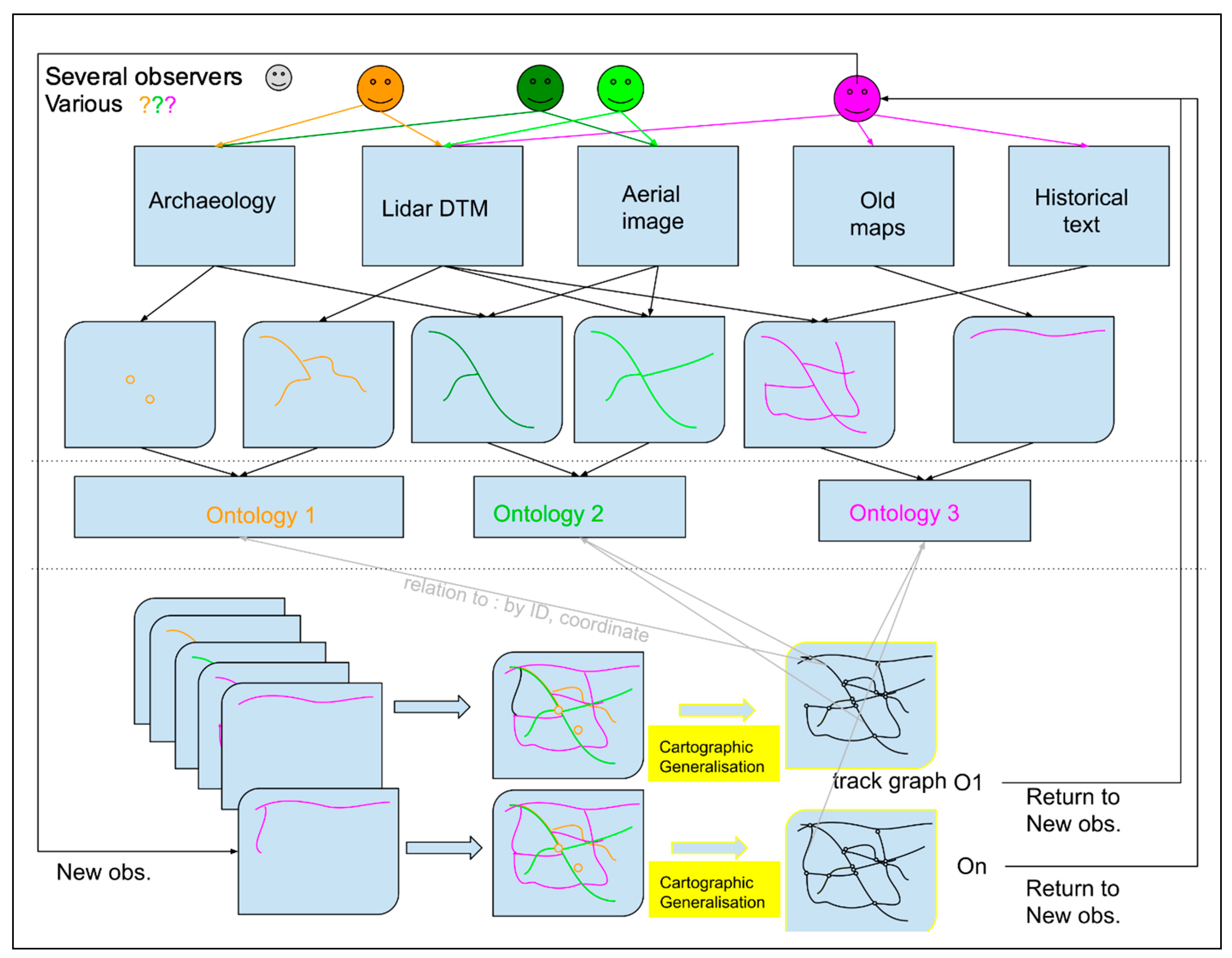
This is particularly relevant when considering how we generate knowledge through repeated observation and construction of hypotheses (Figure 10). In the hermeneutic spiral [19,57,58], the stage of data analysis is crucial in formulating hypotheses and conceptual models. Pattern recognition and hypothesis formulation are often strongly dependent on specific analytical techniques, such as remote sensing, GIS, network analysis, statistics or simulation modeling, which presuppose a formalized structure for the observed data. Therefore, we propose the track graph as a data structure that will allow for a relatively wide range of analytical approaches, based on graph structures. The track graph collapses all (hypothetical) evidence of movement observed, present and past, into a set of nodes and edges that can be supplied with an unlimited array of attributes. These attributes can be associated to each element of the graph through logical reconstruction via ontologies that describe and structure the body of knowledge according to various world views.
From a methodological point of view, we can subdivide our conceptual workflow into three phases (Figure 10). The first phase is observation from one or more data sources (fieldwork records, imagery, LDTM, maps, historical documents, etc.). The observers identify archaeological features in the available set of data using a shared or individual observation protocol. While this can induce biases (see part 1), we argue that even if they appear inconsistent in the first instance, these different observations can complement each other within a given study area. In order to identify characteristics, observers also pre-interpret them in relation to a particular problem or question, a more or less defined conceptual framework, and a body of knowledge on which their expertise is based. In doing so, they develop hypotheses and an initial conceptual model to drive their observations and the way they will record and interpret them.
The second phase consists of analyzing these observed datasets, considering the way they have been recognized and interpreted from the point of view of the movement process, in order to propose a schema of the concepts used and the links established by the observers to relate various concepts. This is precisely what we attempted to do by applying an ontological approach to each of the case studies analyzed in this article. This exercise makes it possible to select all the characteristics regardless of their name or morphology and to associate them in a generic domain of “potential path”. For instance, agricultural terraces or headland ridges, which are not strictly defined as roads, are nevertheless attached to this generic domain of “potential path”. In the cases studied, the features identified all have a spatial reference that is conventionally represented by lines and points. Within the same study area, these heterogeneous layers of information, grouped under the generic domain, can then be combined. Their cartographic generalization allows them to be represented in the form of an abstract geometric model composed of nodes and edges, which constitutes the track graph.
In the third phase, we can explore the logical reconstruction of plausible paths or even movement patterns, for a given time period. This relies on the track graph together with complementary knowledge and data. In the approach developed here, the track graph is a skeleton of plausible tracks, which define the “playing ground” within which we can explore different hypothetical models of movement practices (induced models) and interpretations using, for example, rule-based or agent-based simulation models. Based on several domains of knowledge (“routes”, “networks”, “trajectories”) organized within different ontologies, we can produce various models of movement. Then, the track graph allows us to identify connections between objects that are coming from different observers and methodologies (see the discussion of bias in Section 1) related to these models of movement.
Subsequently, the abstract object represented by the track graph can be used to reconstruct several types of significant networks. These may be recontextualized a posteriori with temporal attributes, material expressions and socio-environmental conceptions of movement, and clearly defined by a new ontology based on spatial relationships within the graph’s network and on a set of contextual knowledge. Following this approach, the same set of nodes and edges may be articulated differently depending on the model of mobility chosen. For example, we might compare the articulations produced by a regional transport road or a farmer’s trajectory in the course of his daily activities. An edge, corresponding to an archaeological feature with a specific morphology, can then simultaneously be considered as a formal road segment participating in a planned network, or as part of a trajectory defined by the practice of a farmer’s routine activity.
While these reconstructions remain hypothetical, they have the benefit of being based on all the archaeological evidence observed but being abstracted from the regionally specific frameworks implicated in their attributes. The link to these attributes is maintained by an identifier and geographical coordinates linking each segment to one or more observations with specific attributes and ontologies attached, thus making it possible to return to the initial data during the evaluation phase of the reconstruction.
The third step of this conceptual workflow is still a work in progress. In the remainder of this article, we will therefore focus in more detail on the concept of the “track graph”, its construction, and its articulation with two other concepts coming from our observational ontologies: The “pathways system” and the “path framework system” (discussed in Section 4).

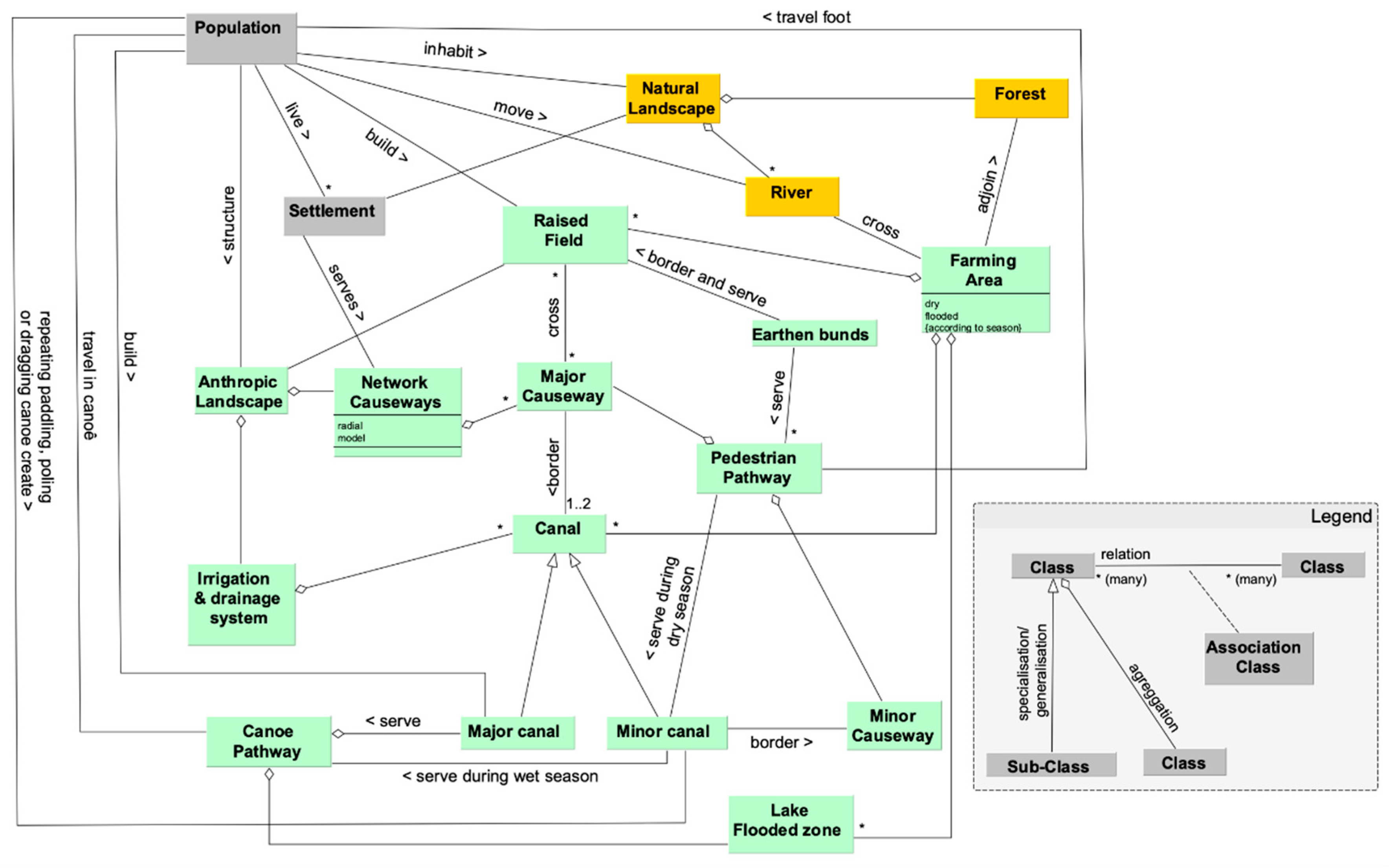
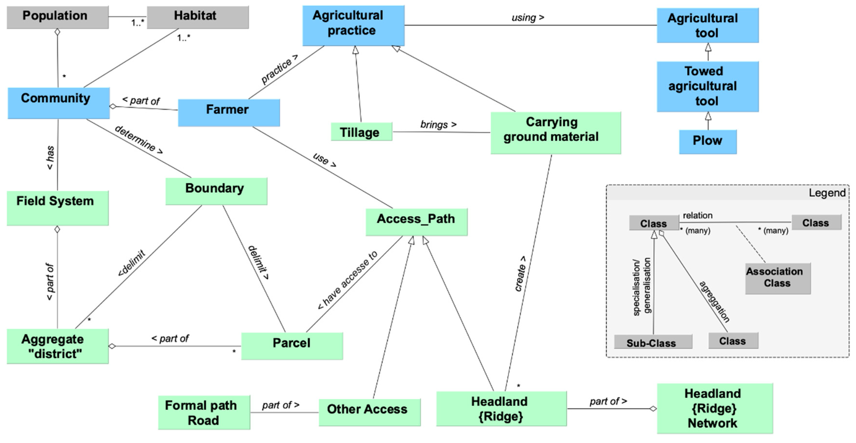
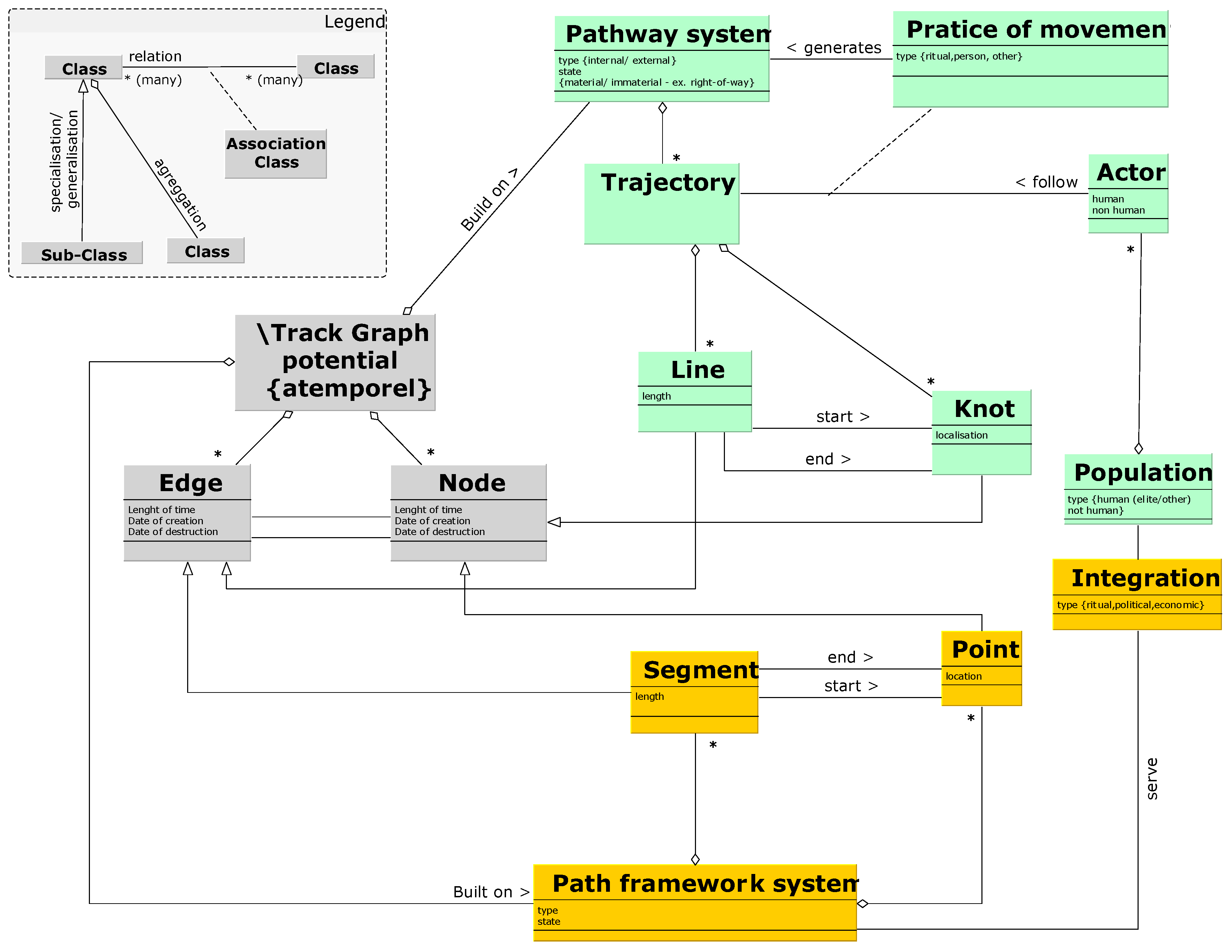
5.2. Track Graph Composition

We define the track graph as an abstract object, composed of a set of nodes and edges. This approach follows that of representations where geometric entities representing physical features are abstracted from their descriptive attributes, such as the approach formalized in the context of urban archaeology to explore the complexity of the urban fabric [59]. This permits us to clearly distinguish interpreted properties such as type or class, described in the attributes, from the abstract entity, described through the geometry.
A node may represent a place, such as a city, a marketplace, a single dwelling, a marker in the landscape, or an intersection between paths. Such an intersection could be recognized as a junction or crossroad, a semantically meaningful place, or simply as a crossing of two pathways without any specific semantic meaning, for example, the intersection between an animal trail and a hiking trail. The essential characteristic of a node is that individuals and groups can move between them and through them. In other words, a node in the track graph denotes a potentially meaningful place.
Movement itself takes place on the edges, representing features understood to serve as pathways. These can be assigned various attributes, describing their material manifestations or functions. Through time, intersections and places as well as “pathways” can appear, disappear, and reappear. The track graph records and accumulates each observed feature. This geometric graph is expended as observations are made (Figure 11). An observation allows the creation of an edge or a set of edges and nodes, and the same edge can correspond to several observations (from various observers, and/or various sources, at different observation times or according to different protocols).
Edges and nodes are given an ID and spatial coordinates that maintain a link to the initial observations which are described by a set of attributes via an ontology. While some of these attributes are purely descriptive, e.g., size, height, width, length, materials, spectral signature, topological attributes (crossing, next to, etc.), and consequently will not change between different ontological schemas, other attributes, e.g., class or type, might change between schemas. This compartmentalized approach allows nodes and edges to have different attribute sets for each ontological schema and each set of observations. For example, a researcher visually interpreting a LDTM could identify and interpret a linear topographic anomaly as a part of a Roman road. The same feature could be identified and interpreted by a Medieval archaeologist as a field boundary or as a potential pathway for farmers. This type of interpretational controversy is quite common and the source of heated debates when a research team is investigating the development of a landscape [60]. Equally, studies combining multiple surveys for a single area highlight the complexities that arise when combining interpretations generated by multiple teams [61]. The track graph allows us to combine these diverse sets of observations, acting as a dynamic representation of observations, evolving as new ones are made. The track graph constitutes a shared abstract canvas or skeleton that can be used to recompose meaningful systems which can be associated with different worldviews and conceptions of movement.
A single observation, for example a line identified on an aerial image, can also be represented as a set of edges connected by nodes. In this case, the nodes do not have the role of origin or destination but will only link edges to geometrically represent an entity, while some may contribute by representing other observations. This highly abstract structure has several advantages. One is that it allows nodes and edges to be treated as active or inactive. For example, in a set of edges and nodes that represent a Roman road, one of the nodes may also correspond to a junction that allows a farmer to join the road from a terrace edge passageway. In the first case, the node cannot be related to any semantic data, it is a simple graphical convention and is therefore inactive in the graph when it is analyzed as a network. In the second case, the same node is active since it corresponds to an element that has a semantic role, representing a junction of two or more edges.
In the track graph, the network of active places and pathways is only a subset of the total set of realized places and pathways. This graph structure provides a mechanism through which edges and nodes can be activated for modeling movement at specific points in time. A second interest of the track graph which arises from its abstract nature is the possibility to use it as an analytical framework that can be transposed to several transcultural case studies. This allows for the comparison of patterns of paths based on the same structure, while interpreting each of them using the ontology specific to the community under study.

5.3. Summing Up and Making Connections: Track Graphs, Pathway Systems, and Path Framework Systems

In this paper, we illustrated our approach to developing formal models of two types of logic which underpin processes related to movement: The “path framework system” and the “pathway system”, by analyzing a body of literature about a landscape. Then, we explored how these formal models of movement can be leveraged in the interpretation of data from sources such as aerial imagery, LDTMs, field surveys, and historic maps, and how these observations can be integrated through a “track graph”.
To summarize, the “path framework system” and “pathway system” provide complementary models of movement and are intended to be used together. The “path framework system” (Figure 12) is used to describe a path network designed by a society, or at least recognized as such by a group. This includes formal paths which can be used for transport or travel from an origin to a destination. In this conceptual framework, movement is essentially destination-oriented [62]. In developing territorial models, the “path framework system” could be used to model how formal systems of movement contribute to the social, political, or cultural integration of the population.
The “pathway system” is used to describe the trajectory produced by one or more actors through the performance of their activities. This trajectory is essentially informal, although it may include components of the formal road system. In the “pathway system”, the movement is activity oriented rather than destination oriented. The movement logic of the “pathway system” could be approached analogously to the wayfaring process, as developed by Ingold [31], but associated with the idea of habitus [47,48], which over the long term produces a collectively created imprint in the landscape.
The “track graph” is a network graph in which each entity (node or edge) represents a physical feature in the landscape, and their physical and spatial connections are represented as connections in the graph. The “track graph” links the two models of movement in a single analytical framework provided by its abstract representation of features in the physical landscape. Unlike the “path framework system” and the “pathway system”, the “track graph” does not contain any interpretations of what the features represented are used for or when they were in use. It only acts as an abstract support for both conceptual frameworks. Its structure, composed of edges and nodes, is simply a convention to facilitate analysis.
In the articulation of the three concepts, the handling of time deserves careful attention. As explained, the “track graph” is a set of nodes and edges that covers the total of all observed and inferred potential paths and places, regardless of their chronological range. In this sense, the “track graph” itself historically and archaeologically atemporal, conflating features from all periods. At a given moment of observation (O1), the “track graph” structure records the totality of the realized or potential paths and can be used for exploring plausible paths, using a specific ontology describing movement behaviors and associated knowledge about a given space-time (Figure 11). New observations may be added to the “track graph”, tagged with their observational moment (O2…On), capturing the development of the understanding of the landscape and movement in it through an iterative process of modeling, observation, and interpretation. The temporality of the “track graph” is related to the time at which the observations are made, at which we have arrived at a particular state of knowledge.
Unlike the “track graph”, the “pathway system” and the “path framework system” are historically and archaeologically temporal. They are chronologically bounded and their dynamics reflect a dynamic that is historically meaningful. In archaeology, we are interested in analyzing patterns and dynamics within a time frame (T) with defined durations (from t0 to tn). Therefore, we can refer to different reconstructions of movement patterns (induced models) as being valid for a particular time frame, defining the nodes and edges that were present at t0, and defining which ones become active or inactive until the end date tn. Thus, within our time frame T, we can have reconstructions R1,…,Rn.
Then, modeling techniques can be used to simulate movement and establish routes within the track graph structure. This is, for example, what happens in an application such as ORBIS (http://orbis.stanford.edu/), where a network of Roman roads and cities is used to explore different travel routes within the Roman Empire. Within this static network, which forms a typical example of a path framework system, routes can be defined as subsets of nodes and edges that are connected for the purpose of a single, individual journey. These routes can be short or long, straight or circuitous, and can be connected to and nested in other routes. Simulations similar to these can explore various manifestations of one or more movement behaviors at a single point in time, for example focusing on understanding the consequences of uncertainties in data attributes [63,64,65] to assess the plausibility of routes.
Next, we consider the role of nodes in the “track graph”, and how they are used in modeling the trajectories of journeys made within the framework defined by the “pathway system”. The concept of the “pathway system” is rooted in the paradigm of the meshwork, a theoretical framework radically different from that of a network, and consequently any modeling within this meshwork-based paradigm requires a fundamentally different approach [31]. In a meshwork, we focus on the people who move through the landscape and how their practices of movement cause “knots” to emerge. These “knots” are defined as places where their journey’s trajectories intertwine (an interweaving of lines in Ingold’s language). Visually, these are places where the physical features associated with movement intersect, but which have no semantic meaning for the actors involved in their journeys as they move along these pathways. An example of this kind of knot is the intersection between a paved road and the route taken by a roe or a wild boar moving across the landscape (Figure 13).
In contrast to the situation in the network paradigm where each node is a point of connection, the knot of the meshwork paradigm is not, a priori, making a meaningful connection between routes. In order to articulate these two conceptions, the network and the meshwork, in a formal and operational model which can be used in graph-based analyses and calculations, we have chosen to treat these knots as nodes within the “track graph”. This is a pragmatic decision taken because when constructing a graph in most current software systems it is a technical necessity that the nodes are present as fixed features, rather than being dynamically generated during the running of an analysis. To reconstruct the plausible paths or the circulation patterns which might have been used by actors moving around the “track graph” at a given moment or period of time, we use attributes to assign a node, acting as an entirely abstract element on the graph, the function of a “connector” (active nodes) or a “knot” (inactive nodes). This approach semantically separates the presence of a node in the graph from its usual function as a connector.
To explore this idea, consider a research exercise in which a team models movement through the landscape at two different moments in time. In the first moment, the junction between a farmers’ path crossing a road has a specific meaning for farmers and is recognized and marked by a group of farmers as a crossroads. Therefore, it is an active node having the function of a connector in the track graph when running a model simulating movement through the system. In the second moment, the formal road exists, but there is no place marked by a group as an official crossroads. In this second moment, although the direction of the farmer’s travel may change, turning from the farm path onto the road, and this may be represented in the simulation as a change of direction between two edges geometrically separated by a node in the “track graph”, this node will have an inactive status because it is not acting as a connector because it is not a “crossroads”—a recognized destination or otherwise meaningful feature in the landscape. The assignment of “active connector” or “inactive knot” attributes to nodes on a graph provides a mechanism through which we can attempt to implement network analysis and modeling approaches dependent on graphs within the conceptual model of a meshwork.
Through dynamic simulation, using an agent-based modeling (ABM) for example, a large set of reconstructed individual trajectories can emerge, using various combinations of the track graph elements, which change at each iteration. The trajectories emerging at ti, based on the modeled behavior of the agents, and related to the pathway system, will lead to the creation of a specific set of “pathways” encapsulated in a set of edges and nodes within the track graph. These sets will have an effect on modeled trajectories in the next iteration at ti+1, because the existence of pathways influences the beliefs and knowledge of subsequent groups of agents. This provides a mechanism for the simulation to drive changes in the attributes of nodes and edges in the “track graph” (e.g., “crossroads”, “path”) from iteration to iteration. Models such as these can be used to validate specific hypotheses, for example if observed formal “path framework systems” could have served other purposes, or if certain movement practices imply or preclude the combined use of path framework and pathway systems.

6. Some Conclusions and Implications of This Approach for Practices of Archaeological Knowledge Creation in the Contemporary Context

In this paper, we presented an approach to archaeologically studying the diverse expressions in the physical landscape of phenomena, such as movement, through a process of semantic modeling of domain literature and observation-based interpretation using fieldwork and remote sensing data. We focused on movement in three contexts, highlighting the variability in archaeologically recognizable physical evidence for movement and in the concepts and language used to describe movement and its infrastructure. The increasing use of extensive remote sensing datasets and, in particular, the uptake of machine learning to scale up identifications of archaeological features in the landscape motivated the development of this approach, which aims to guard against uncritically reinforcing standardized and strongly codified ideas about how complex phenomena appear in these data.
The impact of the current step-change in the scale of available archaeological data on our approaches to interpretation and recording—our practices of knowledge creation—echoes the impact of the vast increase in the amount of archaeological data generated through fieldwork associated with the expansion of development-led archaeology. While the study of relatively small scale artefactual collections and research-led fieldwork, designed to support the observation of material traces of past human behavior through survey and excavation, dominated much archaeological knowledge creation in the first part of the 20th century, the importance of development-led archaeology increased in the late 20th c., accelerated in the 1990s by the new legislation [66]. This shift in the context of the production of archaeological information, from one primarily constructed around the interests and practices of individual researchers and institutions, and dependent on limited dedicated funding, to one based on the needs and practices of market-driven heritage management, with total funding at a much greater scale, which today continues to increase the scale of archaeological work, led to the proposal and development of new approaches to fieldwork, data collection, and data management [67,68,69]. Adding to the collection of new data from excavation and survey, diverse scientific techniques, from isotope analysis, to micromorphology, to aDNA are increasingly applied in connection with archaeological fieldwork [6,70]. These each generate bodies of observational and metric data as well as interpretations, following their own specific standards.
The myriad problems of strongly codified recording and reporting norms associated with the professionalization of archaeology and the attempts of practitioners to deal with their burgeoning data in the late 20th c. have been discussed at length, particularly in the context of excavation [8,40]. The standardization of survey recording and reporting practice, motivated by its increasing use for creating archaeological inventories, meeting regulatory requirements, and other forms of heritage management [71,72], is similarly recognized as problematic. Despite these widely acknowledged problems, in practice the standardization of recording and reporting for both excavation and survey has increased.
This latest step-change is propelled by improved methods and decreasing costs of collecting extensive observational data, notably through remote sensing methods including satellite imagery, UAV-based sensing, and geophysical prospection. While these datasets have been large by archaeological standards for some time, their scale has grown exponentially in recent years. More importantly, while until recently the archaeological use of these data resources has been constrained by the pace of manual interpretation, improvements in machine learning and automated feature detection, notably since the 2010s (see, e.g., [4,5,73]), are speeding their interpretation.
At present (2020), the imperative for integrating this morass of digital information to produce coherent, compelling, data-embedded archaeological narratives is frequently argued in connection to the archaeology’s ability to contribute to debates on societal, climate, and environmental issues [3]. This emerging drive to re-articulate archaeological data to address contemporary agendas has implications for the development of new practices of archaeological knowledge creation. There is great potential to re-articulate archival data and synthesis of past research to play an important role in these debates, and to bring to bear the information created through the interpretation of large-scale remote sensing data. However, we must do so thoughtfully. The challenges of re-reading and re-interpreting the records, reports, syntheses, and analyses which emerged from evolving fieldwork practices and contextual understandings, as discussed in the debates over standardization and as illustrated throughout this paper, are substantial. The challenges of the interpretation of remote sensing data, as discussed here, are similarly daunting.

7. Conclusions

This paper illustrates one example of how we might combine and re-articulate the information, as well as ideas produced through working with observational data and synthesis of reports and research literature. We set out to investigate the influence of the use of context- and observer-specific terminology on the study of past movement processes and pathway patterns based on observed features. Our analysis of the terms and interpretive frameworks used to describe pathway systems in three different case studies revealed a discrepancy between how pathways, recognized through fieldwork and on digital imagery, are recognized and interpreted, and the conceptualization of the actual movement practices involved.
In all three case studies, we noted that observed pathways can be the result of formal construction and movement practices (e.g., processional ways), as well as of prolonged informal movement practices that generate non-constructed features (e.g., canoe paths) or make use of features initially constructed for different purposes (e.g., terraces, embankments, or headlands). Movement itself can take place over all these different features, or even leave no observable trace. While the attention of archaeological observers often focuses on formal pathways, understanding a movement “system” of the past is only possible when we connect observations to knowledge of the different practices of movement and the processes of pathway generation, maintenance, and renewal. To refocus our collective attention, we need to consider the role of observer bias, not just in terms of methodologies employed, available data sources, or individual expertise, but bias rooted in how knowledge is expressed in natural language in specific knowledge domains in different cultural and linguistic contexts.
We demonstrated that by creating an ontology of movement practices based on text analysis we can attempt to disentangle, structure, and clarify some of the semantic biases involved in the practice of identifying and interpreting features in large observational datasets as carried out by archaeologists whose knowledge base is inevitably embedded in the literature representing the current state of disciplinary knowledge. In this context, developing ontologies can serve as a useful heuristic exercise, aiding in understanding the reasoning behind largely implicit frames of reference and inference, and supporting comparing diverse situations. The breakdown of implicit conceptual references into explicit, logical chains of reasoning which describe basic entities and their relationships enables the use of constituent elements to reconstruct, analyze, and compare practices, such as those related to movement, from the bottom up.
Then, we introduced the concept of the track graph as a possible analytical tool for exploring and comparing pathway systems and movement practices at multiple spatial and temporal scales. The track graph is defined as a set of nodes and edges representing all observed features in a study region that are related to movement. Based on graph theory, it offers possibilities for applying well-established analytical approaches such as network analysis and agent-based modeling. At the same time, it allows for a richer description and understanding of observed features related to movement through the conceptualization, modeling, and connecting of informal pathway systems, as exemplified by the concepts of wayfaring and meshworks.
While the practical application of this approach to new datasets is still on the horizon, we tried to illustrate the potential and necessity of synthesizing data from various sources using a formalized, but not standardized, approach based on ontological reasoning and basic graph theoretical concepts. We hope that this paper will provide an impetus for developing these concepts and tools further to meet the challenges posed for archaeological knowledge creation by current remote sensing data collection and interpretation practices.

Author Contributions

Conceptualization, L.N., P.V., T.L., R.O., X.R., C.F., C.F., S.L. and N.L.; methodology, T.L., L.N., P.V., X.R., R.O.; formal analysis, L.N., T.L., X.R., S.L., P.V.; investigation, resources and data curation, L.N., P.V., C.L., C.F., S.L. and N.L.; writing—original draft preparation, L.N., P.V., T.L., L.N., R.O. (Section 1 and Section 6), S.L. (Table A1); writing—review and editing, R.O., L.N., P.V., S.L.; visualization, T.L., L.N., C.F., S.L., N.L.; supervision L.N.; project administration, L.N., P.V.; funding acquisition, L.N., P.V., X.R., R.O. All authors have read and agreed to the published version of the manuscript.

Funding

This research was funded by the Centre National de la Recherche Scientifique (International Emerging Action (IEA) PICS07899—MOVESCAPE), VU University Amsterdam (CLUE+ Activity Fund 0055), ZRC SAZU Ljubljana, University of Franche-Comté, University of Tours, and University of Glasgow.

Acknowledgments

The research for this paper was partly made possible through the Movescape project thanks to a PICS grant awarded to Laure Nuninger by CNRS, a CLUE+ grant to Philip Verhagen by Vrije Universiteit Amsterdam and funds from ZRC-SAZU to Žiga Kokalj for organizing TRAIL2018 (Postojna, Slovenia). It was also supported by one month invited professor positions granted to Philip Verhagen and Rachel Opitz by the University of Franche-Comté. Travel funds were also made available by the University of Glasgow and by the University of Tours (thanks to the SoLidar project, co-organiser). Movescape workshops were organised in Besançon (MSHE C.N. Ledoux, CNRS), in Tours (MSH Val de Loire and CITERES, University of Tours), in Amsterdam (Vrije Universiteit Amsterdam), in Glasgow (University of Glasgow), and opened to a larger public in Atlanta (CAA2017) and in Postojna (TRAIL2018).

Conflicts of Interest

The authors declare no conflict of interest.

Appendix A

Table A1. Overview of the three case studies discussed in Section 4.
Information Based on the Articles under StudyMaya—Belize, Caracol RegionPrecolumbian—Bolivian Amazon Region (Baures and Llanos de Mojos)Medieval and Early Modern Periods—French Beauce Region
Mapping—GIS
-
study area 170–200 km2-over 1000 individual artificial linear features
-
study area 65 km2
-
extension of the records 500–700 km2 (remote sensing and GIS)—over 1000 individual artificial linear features
-
initial study area 20 km2—5500 field parcels, about 460 headlands linear features (from fieldwork or historical text)
-
study area extents—2500 km2 in Beauce region (remote sensing and GIS)—over 100 000 individual artificial features (PhD in progress, N. Levoguer)
Field survey sources
-
pedestrian survey (ground checked causeways)
-
testing, trenching, and open area excavation
-
pedestrian survey
-
excavations
-
ethnographic field survey with a local informant-guide and interpreter
-
pedestrian survey
Remote sensing sources
-
Landsat imagery
-
IKONOS
-
lidar data (survey 2009)
-
Landsat ETM scenes
-
CORONA Images
-
aerial photographs (oblique photography)
-
IGN aerial photographs (vertical)
GIS sources
-
LDTM (resolution 1m, altimetric precision 5–30 cm)
-
SRTM DEM
-
topographical maps
-
vector maps of cultural features
-
classified vegetation and landuse
-
topographical maps
-
georeferenced historical map (18th century Cassini map, 19th century military maps, 19th Napoleonic land registry)
-
after 2018 IGN ©RGE-ALTI DEM (derived from lidar and photogrammetry, resolution 5m, altimetric precision 0.2 to 0.7 m) - Phd in progress N. Levoguer
Other sources
-
historical text (mid-18th century Jesuit testimonies)
historical texts and map: a plan of terriers which dates from 1696, associated to a terrier which is a register of lands belonging to a single landowner (about 350 declarations of farmers exploiting the land in 5500 field parcels) with in addition several other terriers which date from the 16th, 17th and 18th century, and a series of censiers (register for the tax-census payment) which date from 14th and 15th century
Formal movement features
-
“Causeway heights at Caracol range from ground level to some 3 m above the surrounding terrain. In several cases, the sides of hills were cut away to form the causeway.”
-
“Longer intrasite causeways connect the epicenter directly with non-residential causeway termini at distances ranging from 2.5 to 7.3 km from the Caracol epicenter”
-
2.5 m to max. 12 m wide: “Hatzcap Ceel, an additional 1.9 km east of Cahal Pichik and linked to that site by a 12-m-wide causeway, lies 9.2 km away from the Caracol epicenter”
-
“Major Causeways are highly visible as tree-lined features flanked on one or both sides by canals filled with dark aquatic vegetation, which stands out against the grass-covered savanna”
-
“Major Causeways range in width from 1 to 10 m and elevations vary from 0.5 to 3 m tall; Major Canals are comparable in dimensions. Most Major Causeways-Canals are straight and extend up to 7.5 km, although most are several kilometers long. Pedestrians used the elevated causeways and canoe traffic circulated in the adjacent canal(s)” (Erickson 2009)
The old road network was highly transformed, first in the 19th century with the construction of well-structured road network, then in the 1950s by land consolidation. From the Middle Ages to the 19th century, it was organised as follows:
-
A paved road about ten metres wide, called a ‘paved path’ in 17th century written sources. This route, which undoubtedly dates back to Antiquity, crosses the territory from North to South. It is the Paris-Orléans road, which is essential in the French network (now called “route nationale 20”).
-
Secondary network of 7 dirt roads roughly in a star pattern, used to link the village of Toury with neighbouring villages, hamlets and isolated farms. Local service network. Today, only about one third of these paths are still in use.
Informal movement features
-
“Many causeways, however, are barely above the ground level or are intermixed with agricultural terraces”
-
Shorter intra-site causeways directly connect the Caracol epicenter with certain elite groups at distances ranging from 400 m to 2 km from the epicenter (N 3). One causeway, approximately 430 m in length, acts as a crossroad and directly links two intrasite causeways at a distance of 1.2 km from the epicenter; no nodes or groups are associated with either of its junctions. This causeway was found only through the process of intensive terrace mapping. Even shorter, but still formally con- structed, causeways—or, probably more correctly, vias (N 7)—connect household groups, some clearly non-elite, directly to the various intrasite causeways that connect to the Caracol epicenter. Still other vias join important residential groups directly with various non-residential termini (N 10).
-
Most important is the fact that vias can connect residential groups to causeways at any point along the causeway. Although only a half-dozen instances of vias have been formally noted attaching to Caracol’s longer causesways, detailed mapping of the terraces would undoubtedly turn up other examples.
-
The more common Minor Causeways-Canals were also laid out in straight alignments but are shorter in length and required less construction than the Major Causeways-Canals. These features consist of a single shallow canal (1 m wide and less than 0.5 m deep) with low causeways or berms alongside. My informant-guides and I interpret these shallow canals as precolumbian canoe paths: channels for paddling or poling large canoes across the shallow inundated savanna during the wet season. During the dry season, the channels could be used as routes for pedestrian traffic through savanna grasses. Repeated paddling, poling, or dragging a large canoe through the shallow water can create canal-like depressions over time with minimal planning or labor (Erickson 2009)
-
Many raised field canals have no outlets and raised field blocks are encircled by low earthen bunds (which also functioned as raised field platforms and as a means of pedestrian circulation through the raised fields). (Erickson, Walker 2009)
-
headland are embankment of 10 to 20 m wide, with length ranging from several tens of meters to several hundred meters. The height of these embankments can vary from about 20 cm to one meter high.
-
Network of seasonal, earthen paths, represented on the 1696 plan only if they are not covered by wheat (ploughed paths). These are informal passages, similar to tracks.
-
Network of headlands, totally disappeared since the operations of land consolidation in the 1950s.
ReferencesChase, A.F.; Chase, D.Z. Ancient Maya Causeways and Site Organization at Caracol, Belize. Anc. Mesoam. 2001, 12, 273–281.
Chase, A.F.; Chase, D.Z.; Weishampel, J.F.; Drake, J.B.; Shrestha, R.L.; Slatton, K.C.; Awe, J.J.; Carter, W.E. Airborne LiDAR, archaeology, and the ancient Maya landscape at Caracol, Belize. J. Archaeol. Sci. 2011, 38, 387–398, doi:https://doi.org/10.1016/j.jas.2010.09.018.
-
Erickson, C.L. Precolumbian causeways and canals as landesque capital. In Landscapes of movement. Trails, Paths, and Roads in Anthropological Perspective; Snead, J.E., Erickson, C.L., Darling, A.J., Eds.; University of Pennsylvania Museum of Archaeology and Anthropology: Philadelphia, 2009; pp. 232–252.
-
Erickson, C.L.; Walker, J.H. Agency Causeways Canals and the Landscapes of Everyday Life in the Bolivian Amazon. In Landscapes of movement. Trails, Paths, and Roads in Anthropological Perspective; Snead, J.E., Erickson, C.L., Darling, A.J., Eds.; University of Pennsylvania Museum of Archaeology and Anthropology: Philadelphia, 2009; pp. 204–231.
Leturcq, S. Fonction et devenir d’un réseau invisible: les crêtes de labours dans les terroirs beaucerons (XIVe-XXe siècles). In Proceedings of the Marqueurs des paysages et systèmes socio-economiques; Compatangelo-Soussignan, R., Bertrand, J.-R., Chapman, J., Laffont, P.-Y., Eds.; Presses universitaires de Rennes: Rennes, 2008; pp. 163–174.

References

  1. Demoule, J.-P. Rescue Archaeology: A European View. Annu. Rev. Anthropol. 2012, 41, 611–626. [Google Scholar] [CrossRef]
  2. Haas, V.; van der Schut, P.A.C. (Eds.) The Valletta Convention Twenty Years After—Benefits, Problems, Challenges; EAC Occasional Paper; Archaeolingua: Budapest, Hungary, 2014. [Google Scholar]
  3. McKeague, P.; Corns, A.; Larsson, Å.; Moreau, A.; Posluschny, A.; Van Daele, K.; Evans, T. One Archaeology: A Manifesto for the Systematic and Effective Use of Mapped Data from Archaeological Fieldwork and Research. Information 2020, 11, 222. [Google Scholar] [CrossRef] [Green Version]
  4. Opitz, R.S.; Cowley, D.C. (Eds.) Interpreting Archaeological Popography. Airborne Laser Scanning, 3D Data and Ground Observation; Occasional Publication of the Aerial Archaeology Research Group; Oxbow Books: Oxford, UK, 2013; ISBN 978-1-84217-516-3. [Google Scholar]
  5. Forte, M.; Campana, S. (Eds.) Digital Methods and Remote Sensing in Archaeology. Archaeology in the Age of Sensing; Quantitative Methods in the Humanities and Social Sciences; Springer: Cham, Switzerland, 2017; ISBN 978-3-319-40656-5. [Google Scholar]
  6. Matisoo-Smith, E. Using DNA in landscape archaeology. In Handbook of Landscape Archaeology; Left Coast Press: Walnut Creek, CA, USA, 2008; pp. 521–529. [Google Scholar]
  7. Kintigh, K. The Promise and Challenge of Archaeological Data Integration. Am. Antiq. 2006, 71, 567–578. [Google Scholar] [CrossRef] [Green Version]
  8. Löwenborg, D. Recuperating GIS data from excavations: On the use, or lack of use, of digital archaeological information. In Perspectives to Archaeological Information in the Digital Society; Huvila, I., Ed.; Department of ALM, Uppsala University: Uppsala, Sweden, 2014; pp. 11–23. [Google Scholar]
  9. Lambers, K.; Traviglia, A. Automated detection in remote sensing archaeology: A reading list. Aarg. Newsl. 2016, 53, 25–29. [Google Scholar]
  10. Verschoof-van der Vaart, W.; Lambers, K. Learning to Look at LiDAR: The Use of R-CNN in the Automated Detection of Archaeological Objects in LiDAR Data from the Netherlands. J. Comput. Appl. Archaeol. 2019, 2, 31–40. [Google Scholar] [CrossRef] [Green Version]
  11. Palmer, R. Reading aerial images. In Interpreting Archaeological Topography: Airborne Laser Scanning, 3D Data, and Ground Observation; Opitz, R.S., Cowley, D.C., Eds.; Oxbow Books: Oxford, UK, 2013; pp. 76–87. ISBN 978-1-84217-516-3. [Google Scholar]
  12. Banaszek, Ł.; Cowley, D.; Middleton, M. Towards National Archaeological Mapping. Assessing Source Data and Methodology—A Case Study from Scotland. Geosciences 2018, 8, 272. [Google Scholar] [CrossRef] [Green Version]
  13. Nuninger, L.; Opitz, R.; Verhagen, P.; Libourel, T.; Laplaige, C.; Leturcq, S.; Le Voguer, N.; Fruchart, C.; Kokalj, Ž.; Rodier, X. Developing FAIR Ontological Pathways: Linking Evidence of Movement in Lidar to Models of Human Behaviour. J. Comput. Appl. Archaeol. 2020, 3, 63–75. [Google Scholar] [CrossRef] [Green Version]
  14. Cheetham, P.N. Noninvasive Subsurface mapping techniques, satellite and aerial imagery in landscape archaeology. In Handbook of Landscape Archaeology; David, B., Thomas, J., Eds.; Routledge: Abingdon, UK, 2008; pp. 562–582. [Google Scholar]
  15. Richards, T. Survey strategies in landscape archaeology. In Handbook of Landscape Archaeology; David, B., Thomas, J., Eds.; Routledge: Abingdon, UK, 2008; pp. 551–561. [Google Scholar]
  16. Verhagen, P. Site discovery and evaluation through minimal interventions: Core sampling, test-pits and trial trenches. In Good Practice in Archaeological Diagnostics. Non-Invasive Survey of Complex Archaeological Sites; Corsi, C., Slapšak, B., Vermeulen, F., Eds.; Springer: New York, NY, USA, 2013; pp. 206–229. [Google Scholar]
  17. Watson, P.J.; Leblanc, S.A.; Redman, C.L. Explanation in Archaeology: An Explicitly Scientific Approach; Columbia University Press: New York, NY, USA, 1971. [Google Scholar]
  18. Schiffer, M.B. Behavioral Archaeology; Academic Press: New York, NY, USA, 1976. [Google Scholar]
  19. Hodder, I.; Hutson, S. Reading the Past. Current Approaches to Interpretation in Archaeology; Cambridge University Press: Cambridge, UK, 2003. [Google Scholar]
  20. Case, H.J. Illusion and meaning. In The Explanation of Cultural Change: Models in Prehistory; Renfrew, C., Ed.; Duckworth: London, UK, 1973; pp. 35–46. [Google Scholar]
  21. Childe, V.G. Piecing Together the Past: The Interpretation of Archaeological Data; Routledge: London, UK; New York, NY, USA, 2015; ISBN 1-317-60654-X. [Google Scholar]
  22. Keller, A.H. A Road by Any Other Name: Trails, Paths, and Roads in Maya Language and Thought. In Landscapes of movement. Trails, Paths, and Roads in Anthropological Perspective; Snead, J.E., Erickson, C.L., Darling, A.J., Eds.; University of Pennsylvania Museum of Archaeology and Anthropology: Philadelphia, PA, USA, 2009; pp. 133–157. [Google Scholar]
  23. Folan, W.J. Sacbes of the northern Maya. In Ancient Road Networks and Settlement Hierarchies in the New World; Trombold, C.D., Ed.; New Directions in Archaeology; Cambridge University Press: Cambridge, UK, 1991; pp. 222–229. ISBN 978-0-521-18980-4. [Google Scholar]
  24. Chase, A.F.; Chase, D.Z. Ancient Maya Causeways and Site Organization at Caracol, Belize. Anc. Mesoam. 2001, 12, 273–281. [Google Scholar] [CrossRef] [Green Version]
  25. Chase, A.F.; Chase, D.Z.; Weishampel, J.F.; Drake, J.B.; Shrestha, R.L.; Slatton, K.C.; Awe, J.J.; Carter, W.E. Airborne LiDAR, archaeology, and the ancient Maya landscape at Caracol, Belize. J. Archaeol. Sci. 2011, 38, 387–439. [Google Scholar] [CrossRef]
  26. Fruchart, C. Utilisation de plans forestiers XVIIIe-XIXe siècles pour une étude archéologique des paysages passés de la forêt de Chailluz (Besançon): L’exemple d’un réseau viaire. Bull. Cent. D’études Médiév. D’auxerre Bucema 2016. [Google Scholar] [CrossRef] [Green Version]
  27. Earle, T. Routes through the landscape. A Comparative Approach. In Landscapes of Movement. Trails, Paths, and Roads in Anthropological Perspective; Snead, J.E., Erickson, C.L., Darling, A.J., Eds.; University of Pennsylvania Museum of Archaeology and Anthropology: Philadelphia, PA, USA, 2009; pp. 253–270. [Google Scholar]
  28. Hyslop, J. Observations about research on prehistoric roads in South America. In Ancient Road Networks and Settlement Hierarchies in the New World; Trombold, C.D., Ed.; New Directions in Archaeology; Cambridge University Press: Cambridge, UK, 1991; pp. 28–33. ISBN 978-0-521-18980-4. [Google Scholar]
  29. Robert, S.; Poirier, B. La chaussée Jules-César, résilience d’une grande voie antique dans le Vexin français (Val-d’Oise). In Dynamique et Résilience des réseaux Routiers: Archéogéographes et Archéologues en Île-de-France; FERACF: Tours, France, 2014; pp. 151–167. ISBN 2-913272-38-X. [Google Scholar]
  30. Lefebvre, H. La Production de L’espace; Éditions Anthropos: Paris, France, 1974. [Google Scholar]
  31. Ingold, T. Being Alive: Essays on Movement, Knowledge and Description; Routledge: Abingdon, UK, 2011; ISBN 0-203-81833-4. [Google Scholar]
  32. Trombold, C.D. (Ed.) Ancient Road Networks and Settlement Hierarchies in the New World; New Directions in Archaeology; Cambridge University Press: Cambridge, UK, 1991; p. 277. ISBN 978-0-521-18980-4. [Google Scholar]
  33. Earle, T. Paths and roads in evolutionary perspective. In Ancient Road Networks and Settlement Hierarchies in the New World; Trombold, C.D., Ed.; New Directions in Archaeology; Cambridge University Press: Cambridge, UK, 1991; pp. 10–16. ISBN 978-0-521-18980-4. [Google Scholar]
  34. Llobera, M. Understanding movement: A pilot model towards the sociology of movement. In Beyond the Map. Archaeology and Spatial Technologies; Lock, G., Ed.; NATO Science Series. Series A: Life Sciences; IOS Press/Ohmsha: Amsterdam, The Netherlands, 2000; Volume 321, pp. 66–84. [Google Scholar]
  35. Snead, J.E. Trails of Tradition: Archaeology, Landscape, and Movement. In Proceedings of the Landscapes of Movement Symposium, University of Pennsylvania Museum, Philadelphia, PA, USA, 22 May 2006. [Google Scholar]
  36. Cameron, C.M. How People Moved among Ancient Societies: Broadening the View. Am. Anthropol. 2013, 115, 218–231. [Google Scholar] [CrossRef]
  37. Ogden, C.K.; Richards, I.A. The Meaning of Meaning: A Study of the Influence of Language upon Thought and of the Science of Symbolism; Routledge & Kegan Paul Ltd.: London, UK, 1923. [Google Scholar]
  38. Snead, J.E. Trail of tradition: Movement, meaning, an place. In Landscapes of Movement. Trails, Paths, and Roads in Anthropological Perspective; Snead, J.E., Erickson, C.L., Darling, A.J., Eds.; University of Pennsylvania Museum of Archaeology and Anthropology: Philadelphia, PA, USA, 2009; pp. 42–60. [Google Scholar]
  39. Doerr, M. The CIDOC Conceptual Reference Module: An ontological approach to semantic interoperability of metadata. Ai Mag. 2003, 24, 75–92. [Google Scholar] [CrossRef]
  40. Nicolucci, F. Documenting archaeological science with CIDOC CRM. Int. J. Digit. Libr. 2017, 18, 223–231. [Google Scholar] [CrossRef]
  41. Erickson, C.L. Precolumbian causeways and canals as landesque capital. In Landscapes of Movement. Trails, Paths, and Roads in Anthropological Perspective; Snead, J.E., Erickson, C.L., Darling, A.J., Eds.; University of Pennsylvania Museum of Archaeology and Anthropology: Philadelphia, PA, USA, 2009; pp. 232–252. [Google Scholar]
  42. Erickson, C.L.; Walker, J.H. Agency Causeways Canals and the Landscapes of Everyday Life in the Bolivian Amazon. In Landscapes of Movement. Trails, Paths, and Roads in Anthropological Perspective; Snead, J.E., Erickson, C.L., Darling, A.J., Eds.; University of Pennsylvania Museum of Archaeology and Anthropology: Philadelphia, PA, USA, 2009; pp. 204–231. [Google Scholar]
  43. Leturcq, S. Fonction et devenir d’un réseau invisible: Les crêtes de labours dans les terroirs beaucerons (XIVe-XXe siècles). In Proceedings of the Marqueurs des Paysages et Systèmes Socio-Economiques; Compatangelo-Soussignan, R., Bertrand, J.-R., Chapman, J., Laffont, P.-Y., Eds.; Presses universitaires de Rennes: Rennes, France, 2008; pp. 163–174. [Google Scholar]
  44. Arnauld, M.-C.; Michelet, D. Nature et dynamique des cités mayas. Ann. Hist. Sci. Soc. 2004, 59, 73–108. [Google Scholar]
  45. Snead, J.E.; Erickson, C.L.; Darling, A.J. (Eds.) Landscapes of movement. Trails, Paths, and Roads in Anthropological Perspective; University of Pennsylvania Museum of Archaeology and Anthropology: Philadelphia, PA, USA, 2009; p. 361. [Google Scholar]
  46. Mauss, M. Les techniques du corps. J. Psychol. 1936, XXXII, 271–293. [Google Scholar]
  47. Bourdieu, P. Esquisse d’une Théorie de la Pratique. Précédé de «Trois Etudes D’ethnologie Kabyle»; Travaux de Sciences Sociales; Librairie Droz: Genève, Switzerland, 1972; ISBN 978-2-600-04155-3. [Google Scholar]
  48. Bourdieu, P. Le Sens Pratique; Le sens commun; Les Éditions du Minuit: Paris, France, 1980; ISBN 978-2-7073-0298-4. [Google Scholar]
  49. Beresford, M.W.; St. Joseph, J.K.S.; Joseph, J.K.S.S.; Joseph, J.K.S.S. Medieval England: An Aerial Survey, 2nd ed.; Cambridge University Press: Cambridge, UK, 1979. [Google Scholar]
  50. Baker, A.A.H. A relatively neglected field form: The headland ridge. Agric. Hist. Rev. 1973, 21, 47–50. [Google Scholar]
  51. Laligant, S. Le labour et le détouré; derrière les techniques se cache la société (Damgan, Morbihan). In Proceedings of the Nous Labourons, Actes du Colloque Technique de Travail de la Terre, Hier et Aujourd’hui, ici et là-bas, Nantes, France, 25–28 Octomber 2006; Bourrigaud, R., Sigaut, F., Eds.; Éditions du Centre d’Histoire du Travail: Nantes, France, 2007; pp. 117–132, ISBN 2-912228-17-4. [Google Scholar]
  52. Juillard, É. Formes de structure parcellaire dans la plaine d’Alsace. Bull. Assoc. Géographes Fr. 1953, 30, 72–77. [Google Scholar] [CrossRef]
  53. McOmish, D. Introductions to Heritage Assets: Field Systems. Engl. Herit. 2011, 1–5. [Google Scholar]
  54. Hall, D. The Open Fields of England; OUP: Oxford, UK, 2014; ISBN 0-19-100746-3. [Google Scholar]
  55. Zadora-Rio, E. Les terroirs médiévaux dans le Nord et le Nord-Ouest de l’Europe. In Pour Une Archéologie Agraire: A la Croisée des Sciences de L’homme et de la Nature; Guilaine, J., Ed.; A. Colin: Paris, France, 1991; pp. 165–192. ISBN 978-2-200-37189-0. [Google Scholar]
  56. Trombold, C.D. An Introduction to the Study of Ancient New World Road Networks. Ancient Road Networks and Settlement Hierarchies in the New World; Trombold, C.D., Ed.; New Directions in Archaeology; Cambridge University Press: Cambridge, UK, 1991; pp. 1–9. ISBN 978-0-521-18980-4. [Google Scholar]
  57. Chazan, M. World Prehistory and Archaeology: Pathways through Time, 4th ed.; Routledge: New York, NY, USA, 2018. [Google Scholar]
  58. Ricoeur, P. Soi-Même Comme un Autre; Points essais; Seuil: Paris, France, 1990. [Google Scholar]
  59. Rodier, X.; Saligny, L. Modélisation des objets historiques selon la fonction, l’espace et le temps pour l’étude des dynamiques urbaines dans la longue durée. Cybergeo Eur. J. Geogr. 2010. [Google Scholar] [CrossRef]
  60. Williamson, T. The ancient origins of medieval fields: A reassessment. Archaeol. J. 2016, 173, 264–287. [Google Scholar] [CrossRef]
  61. Rippon, S.; Smart, C.; Pears, B. The Fields of Britannia: Continuity and Change in the Late Roman and Early Medieval Landscape; Oxford University Press: New York, NY, USA, 2015; ISBN 0-19-964582-5. [Google Scholar]
  62. Wallace, A.D. Walking, Literature, and English Culture: The Origins and Uses of Peripatetic in the Nineteenth Century; Clarendon Press: Oxford, UK, 1993; ISBN 0-19-818328-3. [Google Scholar]
  63. Bevan, A.; Wilson, A. Models of settlement hierarchy based on partial evidence. J. Archaeol. Sci. 2013, 40, 2415–2427. [Google Scholar] [CrossRef]
  64. Groenhuijzen, M.R.; Verhagen, P. Comparing network construction techniques in the context of local transport networks in the Dutch part of the Roman limes. J. Archaeol. Sci. Rep. 2017, 15, 235–251. [Google Scholar] [CrossRef]
  65. Prignano, L.; Morer, I.; Díaz-Guilera, A. Wiring the past. A network science perspective on the challenge of archaeological similarity networks. Front. Digit. Humanit. 2017, 4. [Google Scholar] [CrossRef] [Green Version]
  66. Huvila, I. Land developers and archaeological information. Open Inf. Sci. 2017, 1, 71–90. [Google Scholar] [CrossRef] [Green Version]
  67. Evans, T.L.; Daly, P. (Eds.) Digital Archaeology: Bridging Method and Theory; Routledge: London, UK; New York, NY, USA, 2006; ISBN 0-203-00526-0. [Google Scholar]
  68. Kamermans, H.; Gojda, M.; Posluschny, A. A Sense of the Past: Studies in Current Archaeological Applications of Remote Sensing and Non-Invasive Prospection Methods; Archaeopress: Oxford, UK, 2014; ISBN 1-4073-1216-2. [Google Scholar]
  69. Vincent, M.L.; Bendicho, V.M.L.-M.; Ioannides, M.; Levy, T.E. (Eds.) Heritage and Archaeology in the Digital Age: Acquisition, Curation, and Dissemination of Spatial Cultural Heritage Data; Quantitative Methods in the Humanities and Social Sciences; Springer international Publishing: Berlin/Heidelberg, Germany, 2017; ISBN 3-319-65370-9. [Google Scholar]
  70. Pate, D.F. The use of human skeletal remains in the landscape archaeology. In Handbook of Landscape Archaeology; David, B., Thomas, J., Eds.; Left Coast Press: Walnut Creek, CA, USA, 2008; pp. 502–520. [Google Scholar]
  71. Hargrave, M.L. Ground truthing the results of geophysical surveys. In Remote Sensing in Archaeology: An Explicitly North American Perspective; Johnson, J.K., Ed.; The University of Alabama Press: Tuscaloosa, AL, USA, 2006; pp. 269–304. [Google Scholar]
  72. Bonsall, J.P.T.; Gaffney, C.F.; Armit, I. A decade of ground-truthing: Reappraising magnetometer prospection surveys on linear corridors in light of excavation evidence. In A Sense of the Past: Studies in Current Archaeological Applications of Remote Sensing and Non-Invasive Prospection Methods; Kamermans, H., Gojda, M., Posluschny, A., Eds.; British Archaeological Reports International Series; Archaeopress: Oxford, UK, 2014; pp. 3–17. [Google Scholar]
  73. Davis, D.S. Object-based image analysis: A review of developments and future directions of automated feature detection in landscape archaeology. Archaeol. Prospect. 2019, 26, 155–163. [Google Scholar] [CrossRef]
Figure 1. A lidar-derived terrain model with the courses of road axes and tangled paths located in the south-east of the Chailluz massif (Besançon, France) depicted. Location of the surveyed areas and uncovered remains: Lat. 47.28 to 47.31° N–Long. 6.06 to 6.09° E. Source: Lieppec—C. Fruchart [26].
Information 11 00338 g001
Figure 2. The semiotic triangle according to Ogden and Richards [37]: The word (Symbol), the thing (Referent), and the concept (Thought) are connected.
Information 11 00338 g002
Figure 3. Schema of the approach adopted by our team.
Information 11 00338 g003
Figure 4. Locations of the three case studies discussed in this article.
Information 11 00338 g004
Figure 5. Unified Modeling Language (UML) schema of a circulation system at Caracol, Belize.
Information 11 00338 g005
Figure 6. UML schema of a circulation system in the Bolivian Amazon.
Information 11 00338 g006
Figure 7. Map of the area of Toury en Beauce (France) with the main road network and field system shown, characterized by long strip parcels: Lat. 48.16 to 48.22° N—Long. 1.90 to 1.98° E. Source S. Leturcq [43].
Information 11 00338 g007
Figure 8. UML schema of a circulation system in the Beauce region.
Information 11 00338 g008
Figure 9. Remains of headlands in the Beauce region: (a) Remains of headlands parallel to the road into a large contemporary field in Baccon, source N. Levoguer, (b) remains of headland crossing a formal pathway in Toury-en-Beauce, source Collectionneur de Toury 28.
Information 11 00338 g009
Figure 10. The role of ontologies and the track graph in knowledge creation.
Information 11 00338 g010
Figure 11. The track graph creation process.
Information 11 00338 g011
Figure 12. Theoretical structure of the track graph, pathway system, and path framework system.
Information 11 00338 g012
Figure 13. The intersection between a paved road and a trackway made by a wild animal near Pugey (France), source L. Nuninger.
Information 11 00338 g013

