1. Introduction
Over the last two centuries, ancient Buddhist monasteries have been discovered and excavated across Asia. This has led to a large body of literature which, for the most part, has focused on the art contained in them. The study of the Buddhist rock monasteries in Kucha has followed this pattern. My research aims to examine the study of rock monasteries as meaningful religious settlements by carefully analyzing all the remains and not just the artworks found there.
1Crucial information about Buddhist rock monasteries, in fact, might be gathered from features usually left out of the discussion: niches and caves of small dimensions, caves left undecorated or that have lost their decoration, caves that are exceptionally damaged or partially buried, connective architectures, and marks from now lost timber structures. In most cases, such marks have been obscured by preservation efforts or eroded since the photographs were taken.
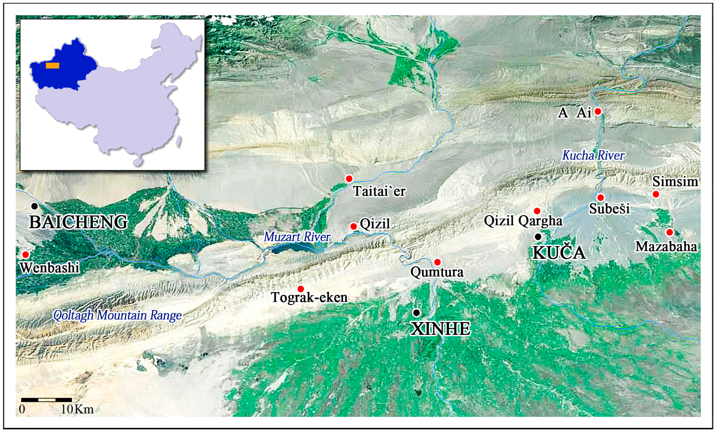
Since the monasteries are in a state of continuing degradation, early documentation needs to be scrutinized to acquire a deeper understanding of the rock monasteries, as the locale where particular forms of Buddhism developed in a specific historical period and showcased the culture of the Kucha kingdom (
Figure 1).
2An untapped source of information comes from historical photographic records; most of the explorers who visited Kucha at the beginning of the 20th century documented their visits to the sites extensively. These records also included photographic surveys, with the German Turfan Expeditions (1902–1914) being the most thorough.
3 While written sources have been carefully studied, these photographs have not received the attention they deserve. More specifically, photographs taken by early explorers show the rock monasteries in a better state of preservation compared to the present, with several of the above-mentioned features still detectable. They not only stand as a persuasive testimony to the degradation by weathering and human activities in the last century, but they also allow the recovery of lost data that can offer a broader comprehension of the rock monasteries and may assist in the selection of preservation techniques in the future.
Analysis of historical photographs from Kizil has, for instance, permitted the identification of features below the present ground or lost during the last century. Additionally, the features of damaged caves and paintings allow for an understanding of the changes the sites went through over the last 120 years.
The following study relies on data acquired from historical photographs and my own fieldwork. Since only a few historical photographs can be published in this short study, the discussion herein is limited to a few crucial samples, to point out patterns and paradigms and propose a method through which these and similar collections of photographs can be analyzed. A comprehensive study is beyond the remit of this paper.
2. Features Detected in Historical Photographs
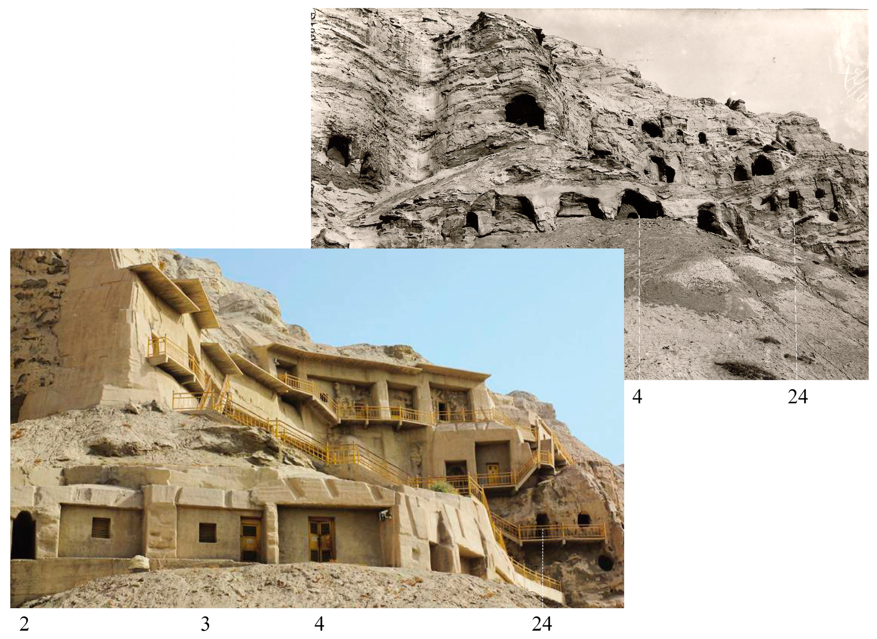
We gather data by comparing the two-dimensional features provided by photographs to similar ones that can still be observed in the rock monasteries of Kumtura, Simsin, and Kizil. At first, we can immediately notice that, though they had already been affected by weathering, the caves in the pictures appear much closer to what they might have looked in antiquity than their current appearance.
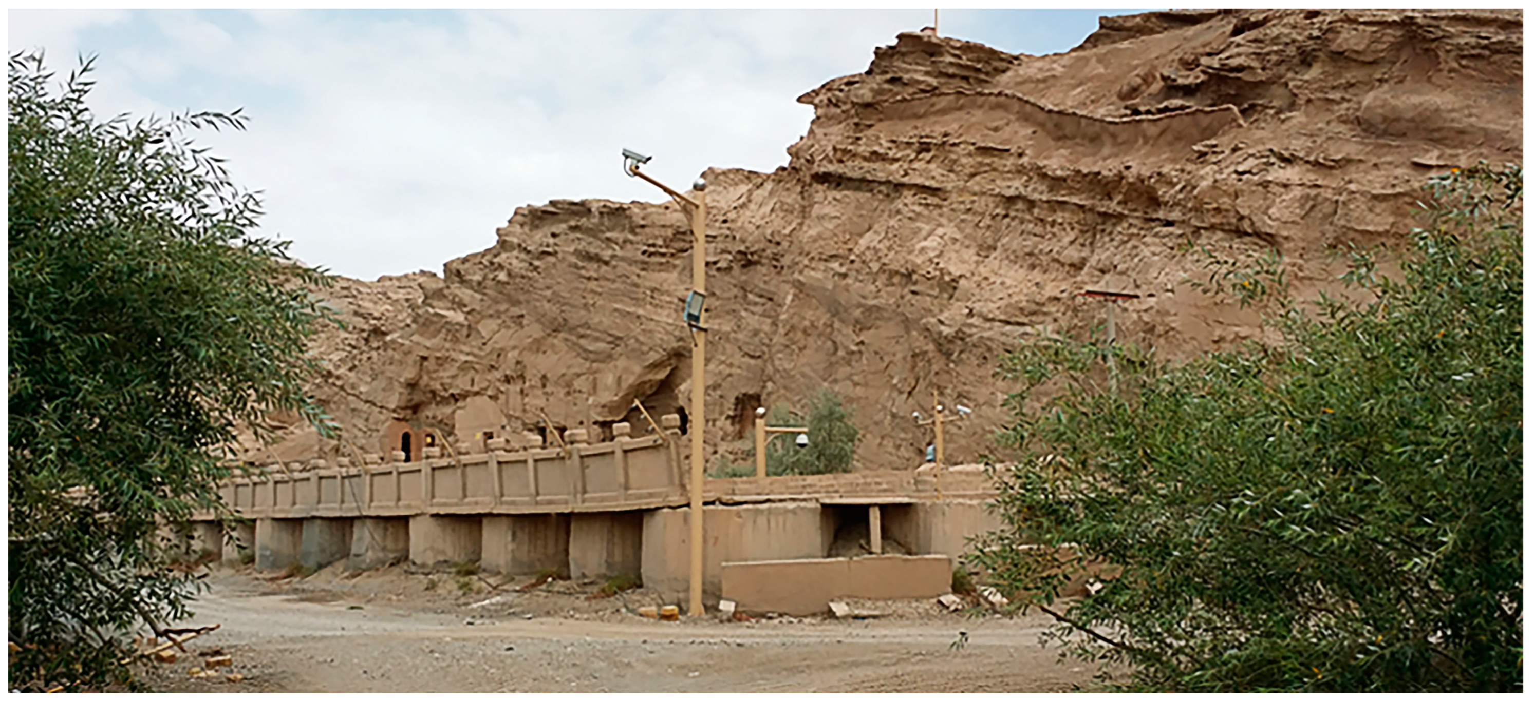
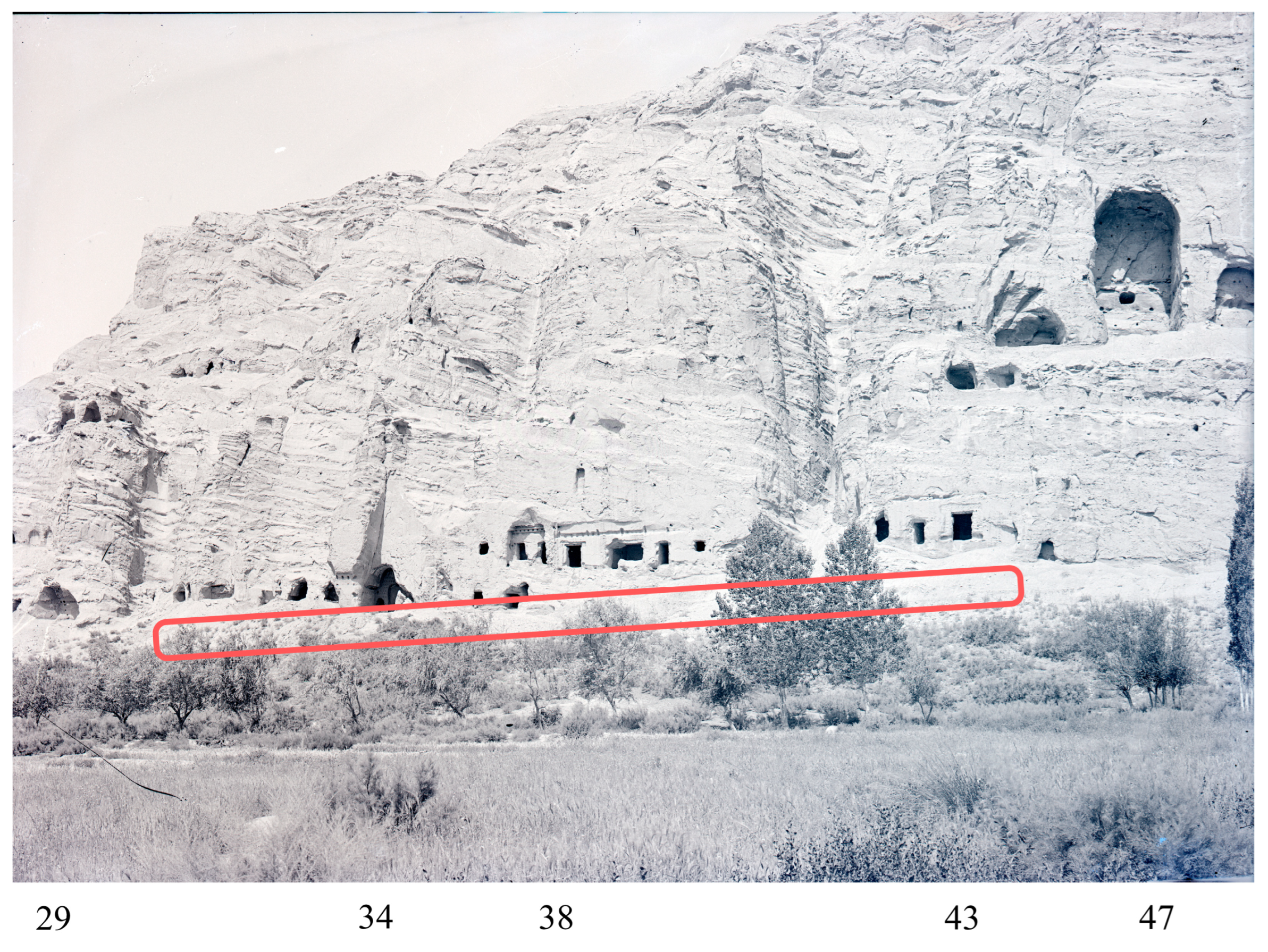
In our investigation, there is a need to constantly reassess the present position of the caves on the cliff against the original ground level. For example, the photographs taken by the German Turfan Expedition show some evident changes in the setting. The stunning scenery surrounding the Kumtura North Monastery (库木吐喇窟群区) has been altered significantly in recent decades. The construction of a hydroelectric power plant downstream has raised the water level of the river. Moreover, in 1981, massive dam-like concrete walls were set up to protect the caves from flooding; in 1991 some of the wall paintings were detached and stored;
4 and the inner walls of the caves were strengthened with potassium silicate (PS) and concrete. The area between the massive concrete dam-like walls and the caves was filled with a thick layer of pebbles, in places to a depth of five meters; thus, not only does the height of the caves on the cliff not correspond to the original one, but the caves can now be accessed only by climbing down and not ascending to them, as was possible originally. The addition of an electric fence and surveillance cameras on high poles in recent years has further impacted the landscape. These interventions deeply affected the caves and definitively ruined the atmosphere of the setting; they not only hinder the view of the caves from a distance, but they also obstruct the view of the surroundings from the caves (
Figure 2).
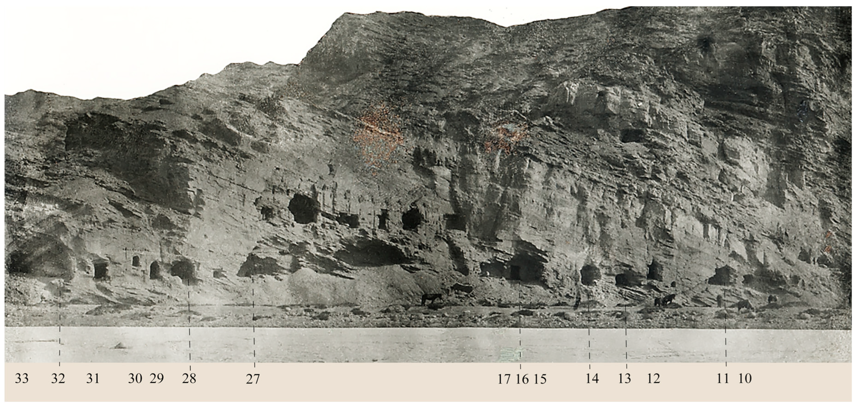
The caves facing the Muzart River have been divided into two districts (Southern District 南区 Caves 1–39, partially seen in
Figure 3, Northern District 北区 Caves 53–72). Large sections of the cliff between Caves 6 to 33 had already collapsed.
5 Most of the antechambers had already suffered much damage and, in some cases, sections of the main chambers too.
6 The damage started occurring to the caves while the site was still in use and continued through the centuries.
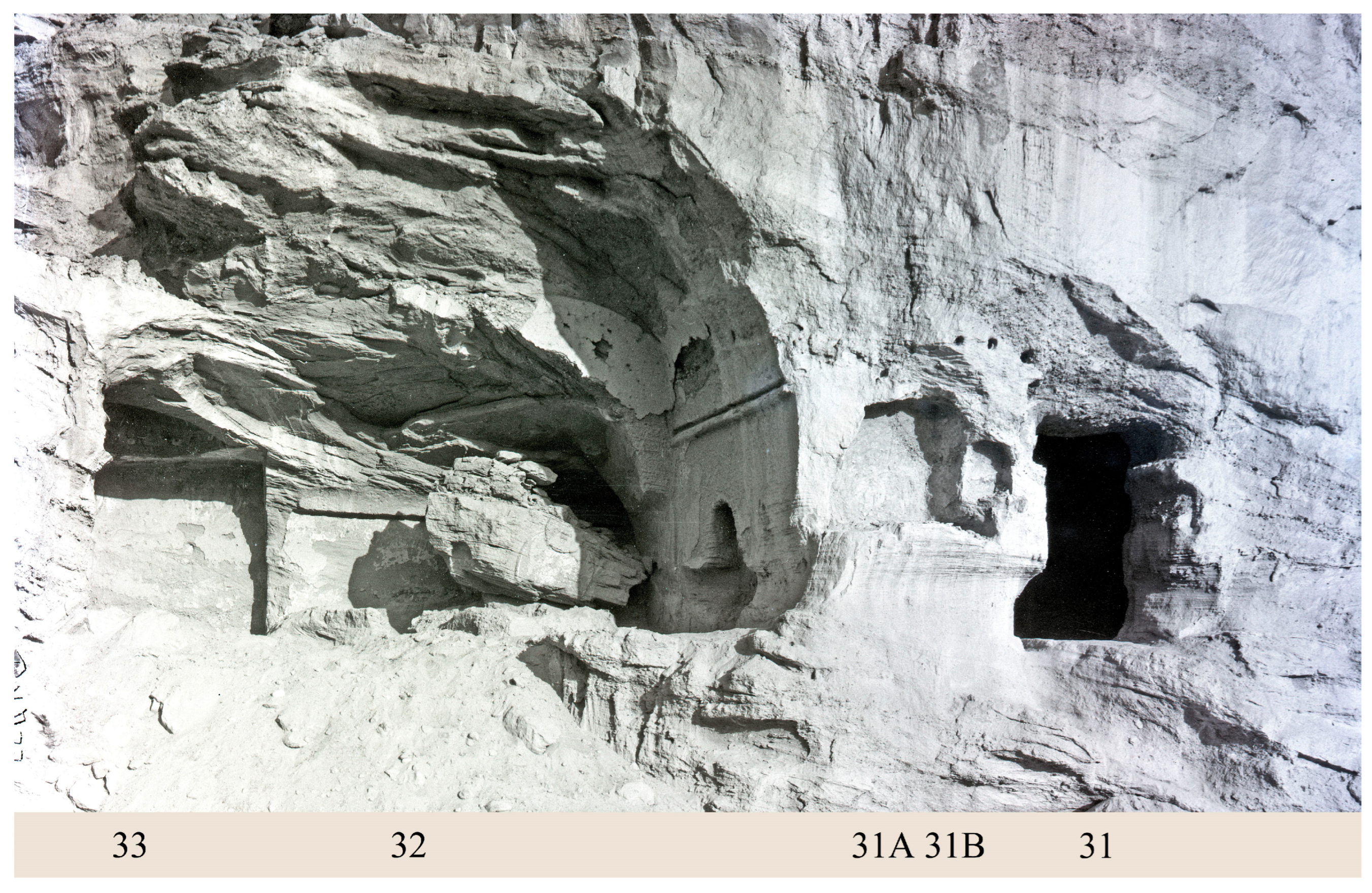
7Photographic enlargement allows for a detailed analysis of the section of the cliff between Caves 23 to 33 (
Figure 4).
8 After a collapse of the cliff that wiped away the rock-carved antechambers, a timber balcony was set up in their place; the presence of this structure is indicated by the row of rafter holes carved at the same height across the cliff, preserved above Caves 30 and 27. This timber structure would have provided a roofed activity area for all the caves in this section.
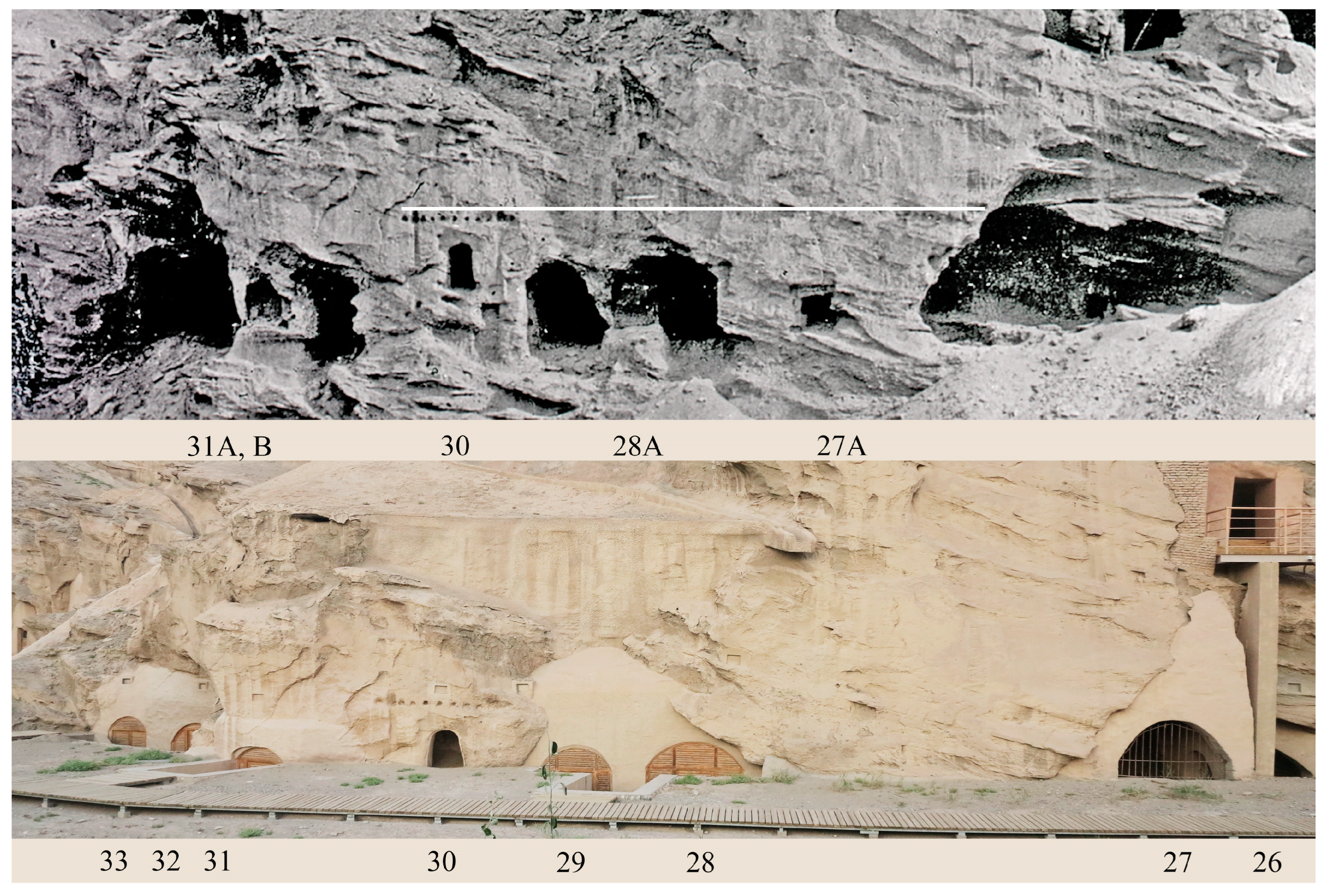
9 Interestingly enough, the historical photographs reveal the presence of five small niches in this relatively short section of the cliff; we will mention them as they are provisionally referred to.
10 Only one niche, Cave 30, is now visible; it was carved in a higher position than the other four.
11The second niche, carved between Caves 27 and 28, Cave 27A, displays grooves on the four sides, indicating that it was fitted with a small door. The third niche, Cave 28A, was carved between the central pillar Caves 28 and 29; it was carved in a section of the rock exposed following the collapse of the antechambers and a section of the front walls of the main chambers of the two larger caves at its sides. The fourth niche, Cave 31A, was carved after the collapse of the front wall of the main chamber of Caves 31 and 32, a situation comparable to that of Cave 28A (
Figure 5). The fifth niche, Cave 31B, was then carved beside it, partially overcutting it.
12The analysis of the historical photographs of the cliff between Caves 27 and 33 has revealed some crucial facts. It has shown that the carving of the niches and the installation of the porch must have been carried out after the damage incurred earlier by the larger caves. Therefore, the caves continued to be locations of religious observance after restoration was carried out.
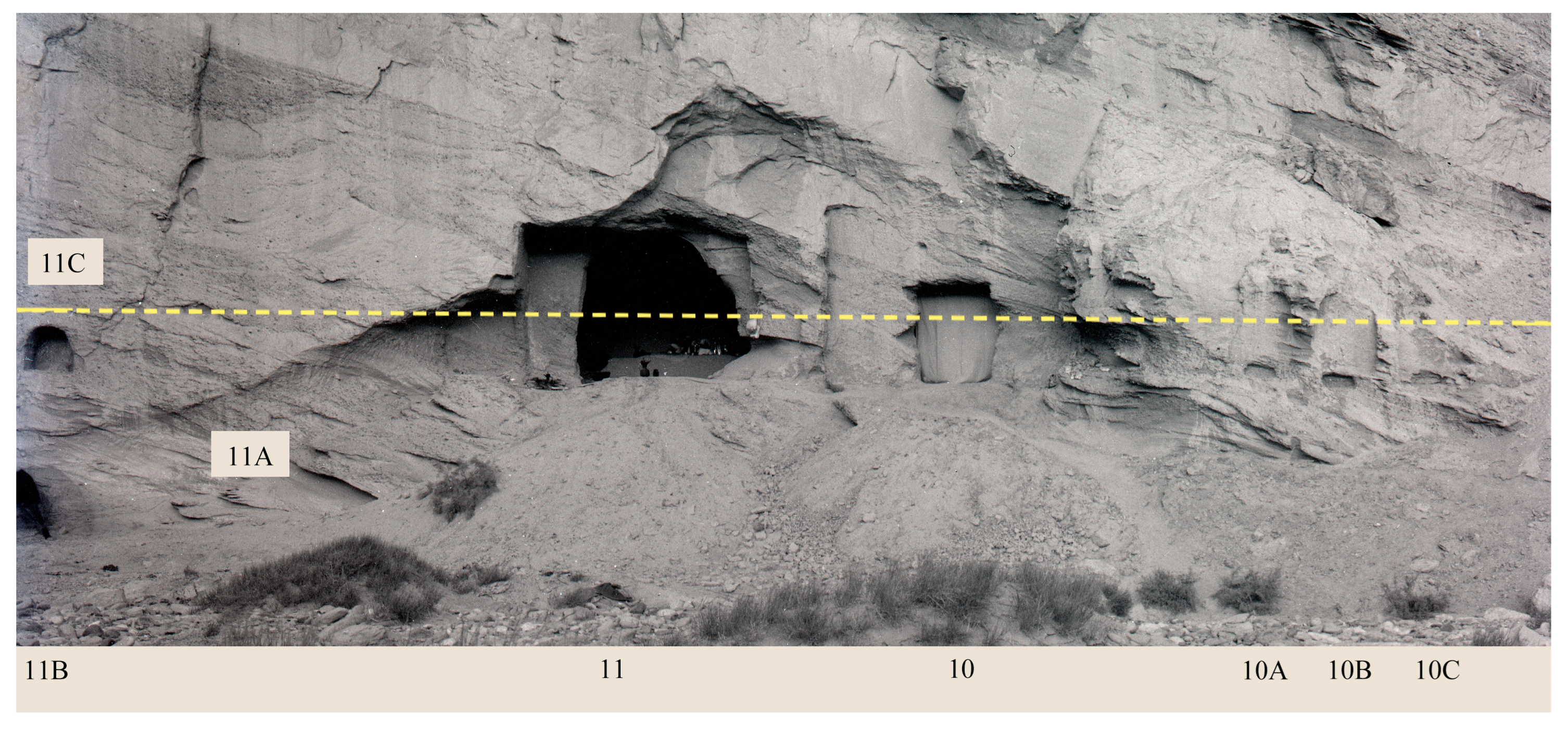
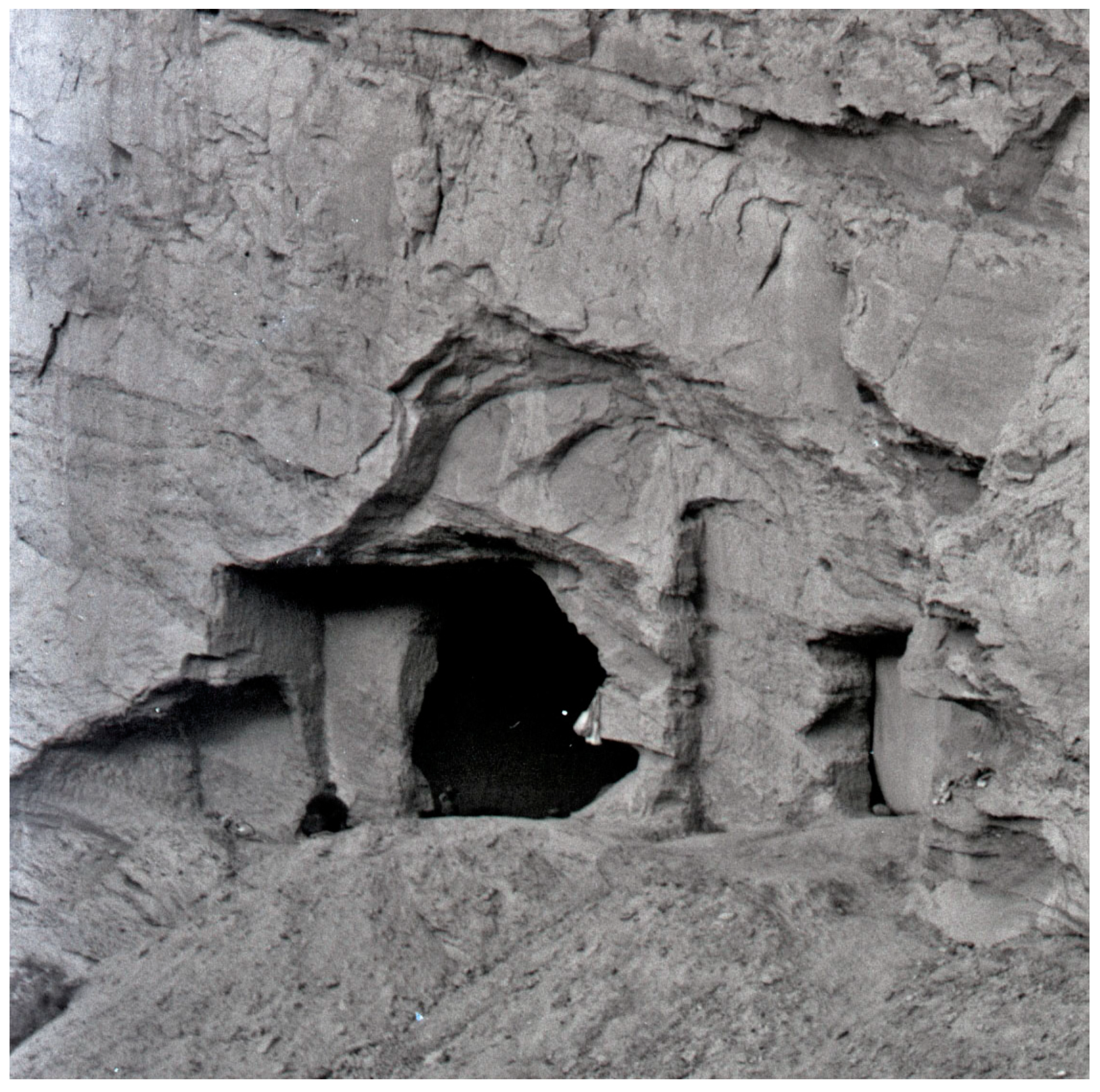
Other interesting facts emerged from the examination of photographs of the southern section of the same cliff, between Caves 10 and 15.
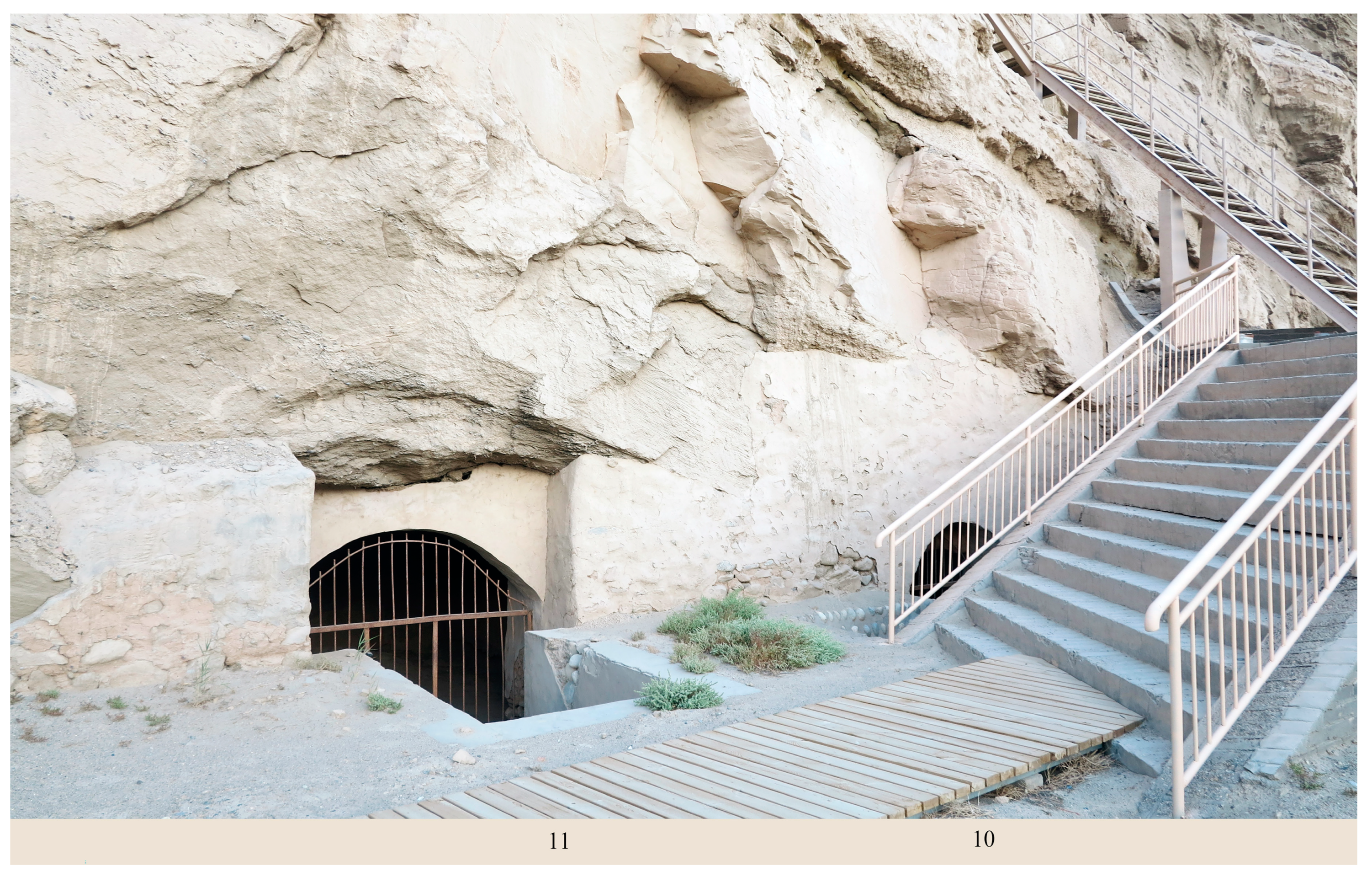
13 Caves 10–11 were reached through a stairway carved in the rock, provisionally numbered Cave 11A, which was subsequently damaged by the collapse of the cliff; such a staircase was still present at the time of the Turfan expedition (
Figure 6 and
Figure 7). It was a quarter-turn stairway, with the lower flight of steps entering perpendicularly into the cliff and the upper flight carved within, parallel to the cliff facade. Originally, the only part of the staircase visible from the outside would have been the access door. Note the small doorway on the rear wall of the landing (11B), likely leading to a small deposit cave.
14 At that time, the stairway reached the antechamber of square Cave 11 from the left, while a doorway hewn into its right wall gave access to the antechamber of Cave 10.
15 The traces of this stairway indicate that the outer face of the cliff in front of the two caves collapsed to a depth of over three meters.
16 On the right-hand side of the photograph, we can identify three small caves, provisionally named Cave 10A, 10B, and 10C, that are carved on the same level as Caves 10 and 11. It can be conjectured that these caves were reached through a passage carved on the right wall of the antechamber of Cave 11 (
Figure 8). From the photographs, we can infer that these three barrel-vaulted ceiling caves were above a meter in height and about one meter wide.
17 Their size and type allow us to interpret them as meditation caves.
18After the outer portion of the cliff collapsed, the lower flight of steps was completely lost, while the upper flight became exposed. Note the very small niche above it, slightly to the right (11C). If we consider the depth of this niche and compare it with the original cliff facade (note 16), we realize that the niche itself could only have been carved after the collapse of the outer section of the cliff.
Access to Cave 10 was granted by a doorway dug through the right wall of the antechamber of Cave 11. Thereafter, a passage hewn into the right wall of the antechamber of Cave 10 allowed access to Caves 10A, 10B, and 10C. A small niche (11C) was carved into a newly exposed section of the cliff after a large collapse of the cliff, which revealed the stairway and devastated the antechambers of both Caves 10 and 11. The absence of grooves and postholes suggests that these caves were not restored after suffering damage.
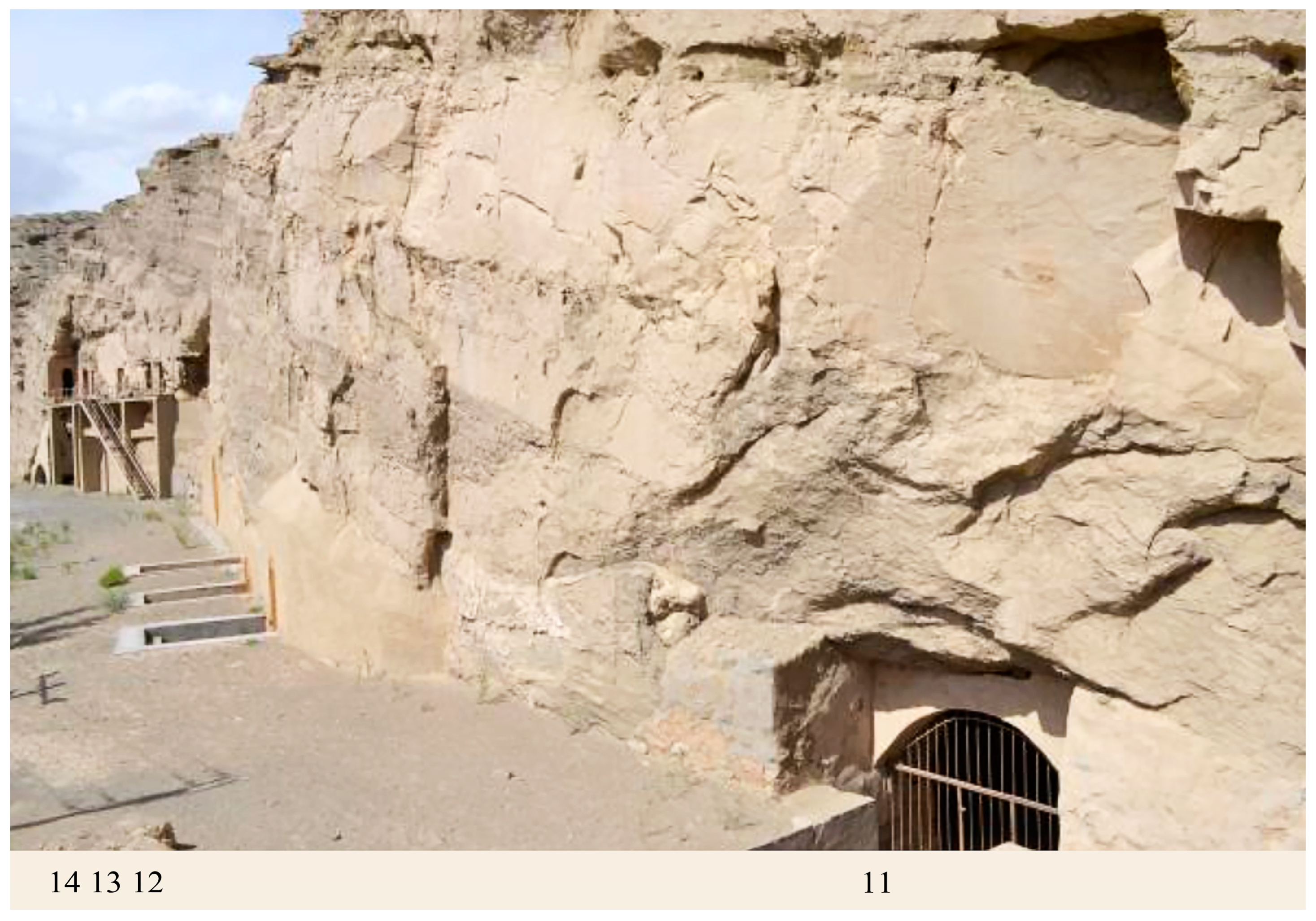
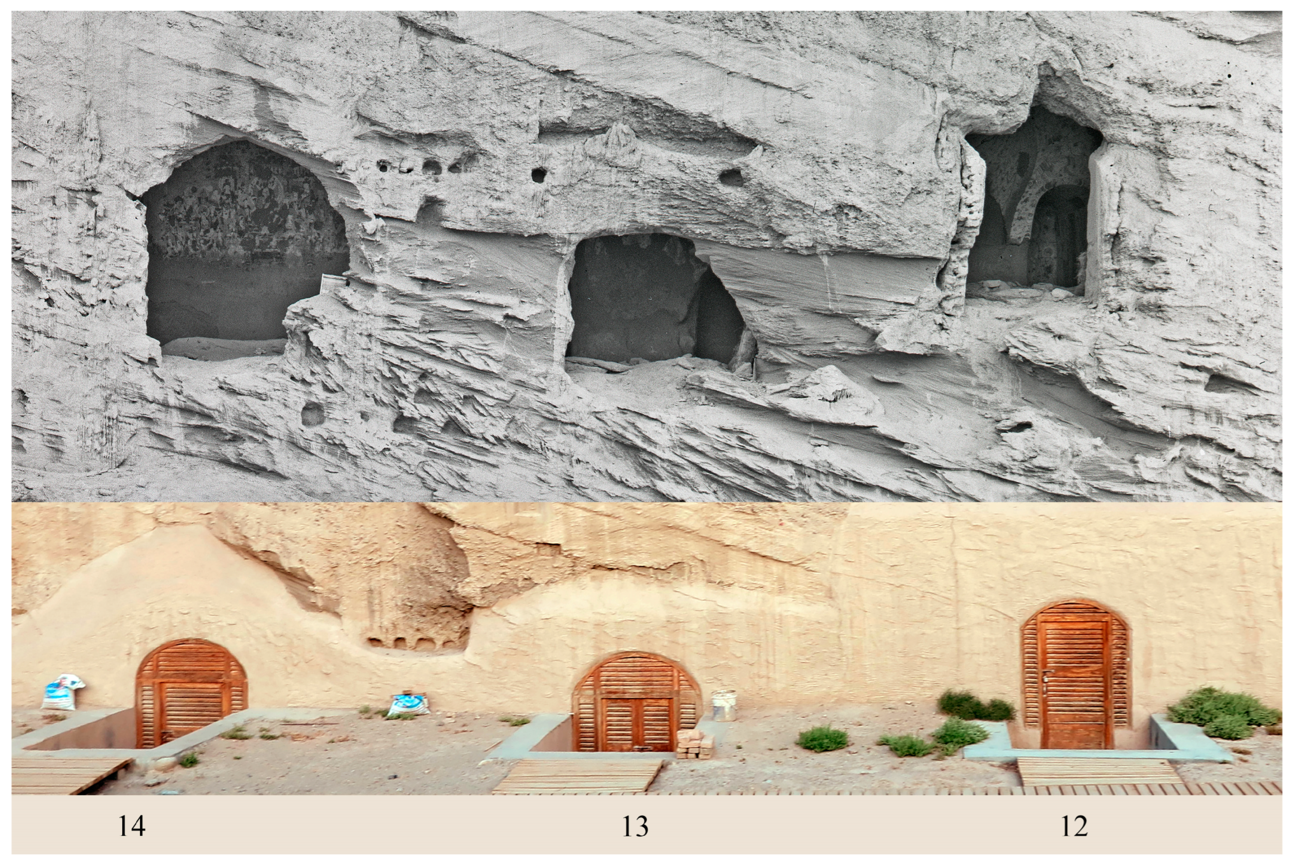
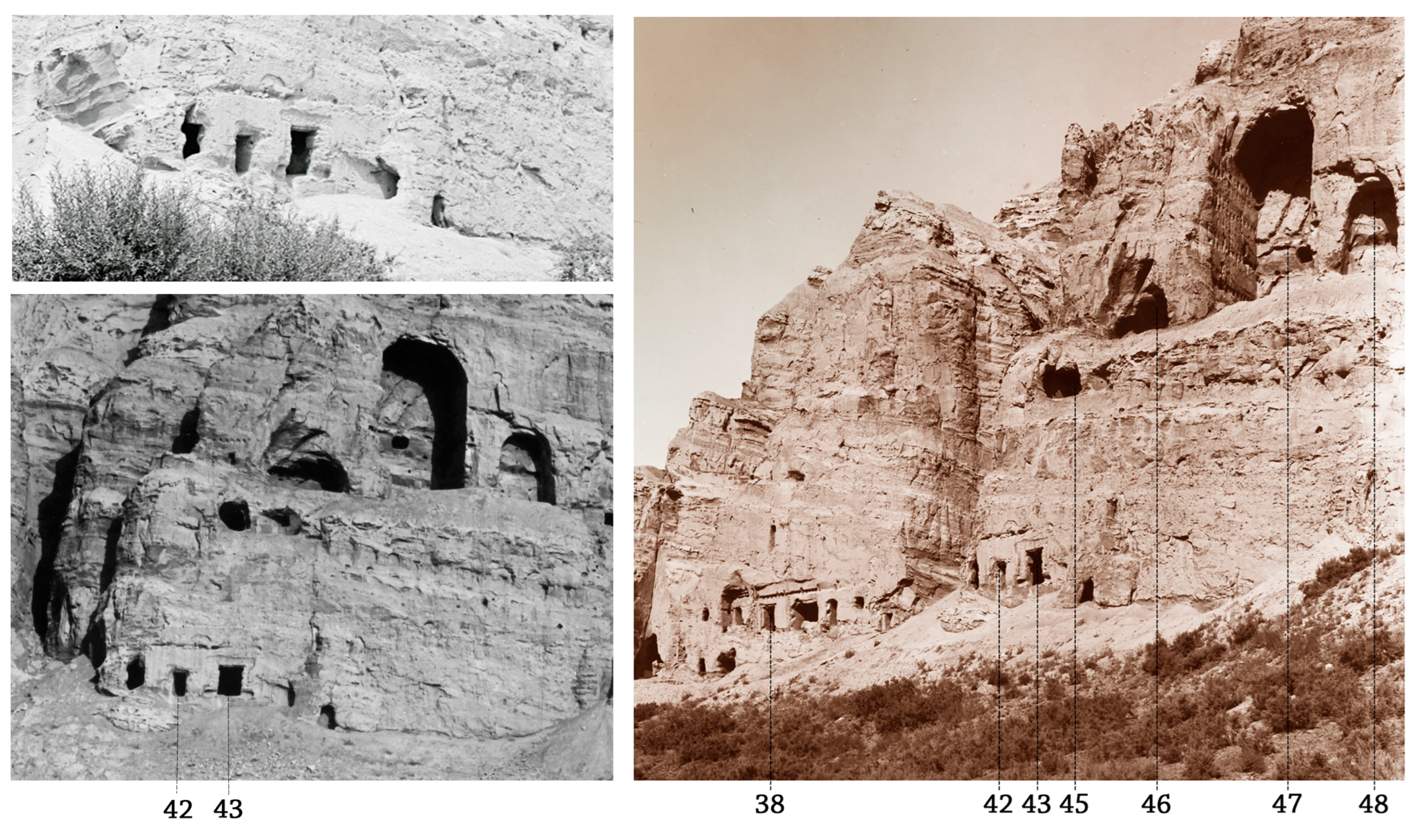
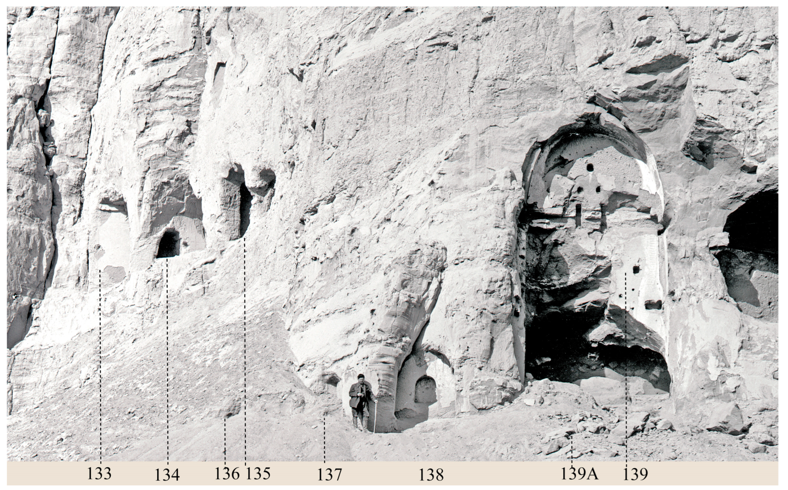
19Slightly to the north of this group are Caves 12, 13, and 14. In modern times, the area in front of them has been filled with strata of pebbles and can now be accessed by descending three separate stairways (
Figure 9). Through examination of historical photographs (
Figure 10), it has become possible to determine their relationship. It can be seen that the central pillar Cave 13 and square Cave 14 were carved at the same level in a relatively high position on the cliff and were presumably reached via a stairway. The floor joist holes and rafter holes indicate that the two caves were repaired after the collapse of their rock antechambers and were connected through the installation of a timber balcony. Therefore, these two caves formed a group similar to the one comprising central pillar Cave 10 and square Cave 11. Cave 12 was carved close to Cave 13 but at a slightly higher position on the cliff. It is an independent later cave, as can be assessed from the Uighur-style paintings.
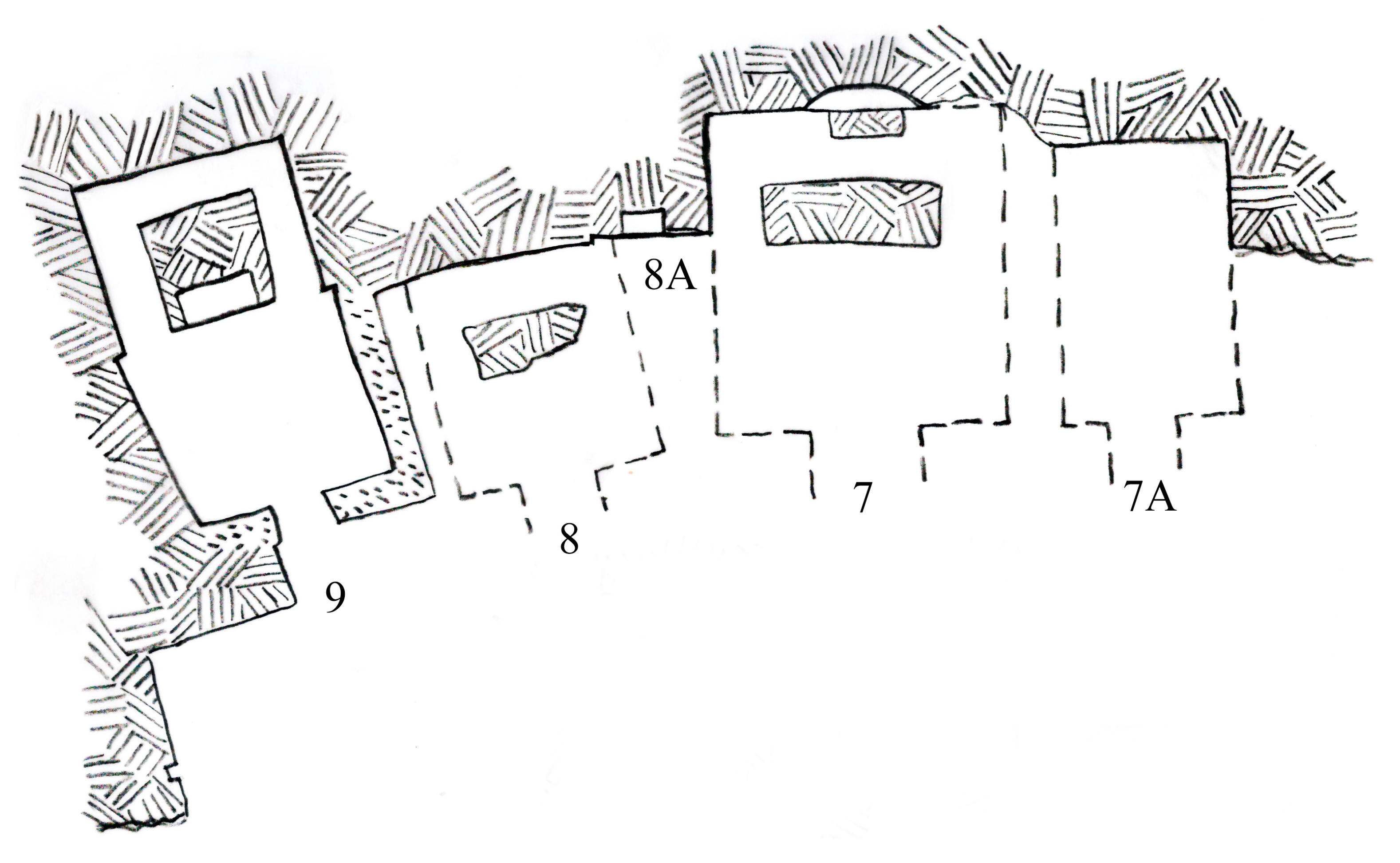
20The clearest example showing that niches were carved after the collapse of earlier larger caves is the niche carved between Caves 7 and 8, provisionally numbered Cave 8A. The caves have almost completely collapsed; the area in between the rear walls of the rear corridors of the two caves was exposed by the collapse. The exposed section of rock between them was subsequently chiseled even, and within this rectified space a niche was then carved (
Figure 11).
The analysis of the historical photographs recording the cliff facade of Kumtura North Monastery from Cave 6 to Cave 33 (Southern District 南区) has revealed several important features that are presently unseen. We learned that the original ground level was much lower than the present one, and therefore the caves were in a more prominent position. They were originally ascended to via stairways, which were carved within the cliff, while they are now climbed down to via modern concrete stairways that give rise to a completely inaccurate impression. Up to nine caves or niches of different sizes and functions and a stairway have been individuated. While some features belonged to the original plan, at least five niches were carved after the cliff collapsed, causing damage to earlier larger caves.
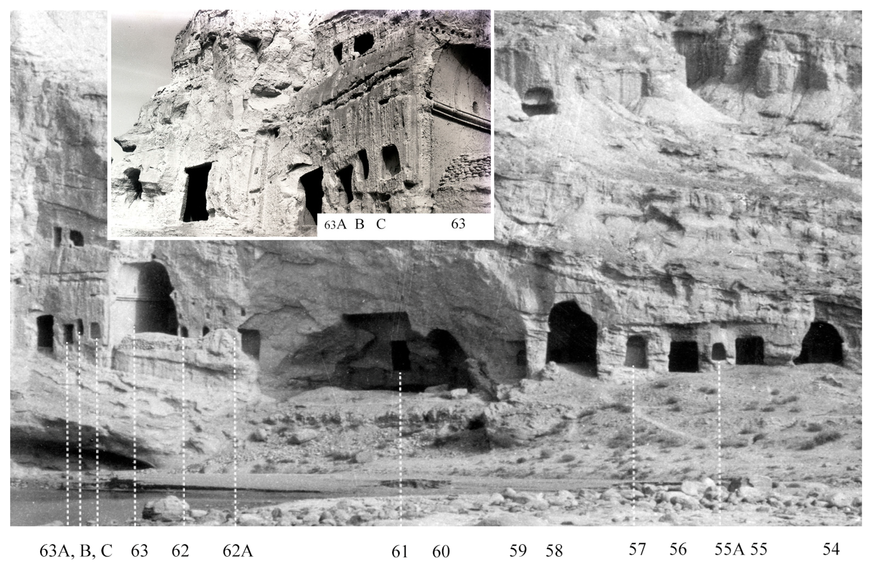
Aside from the large cement wall and the pebble filling in front of the caves, there have been significantly fewer changes in the Northern District (Caves 52–72,
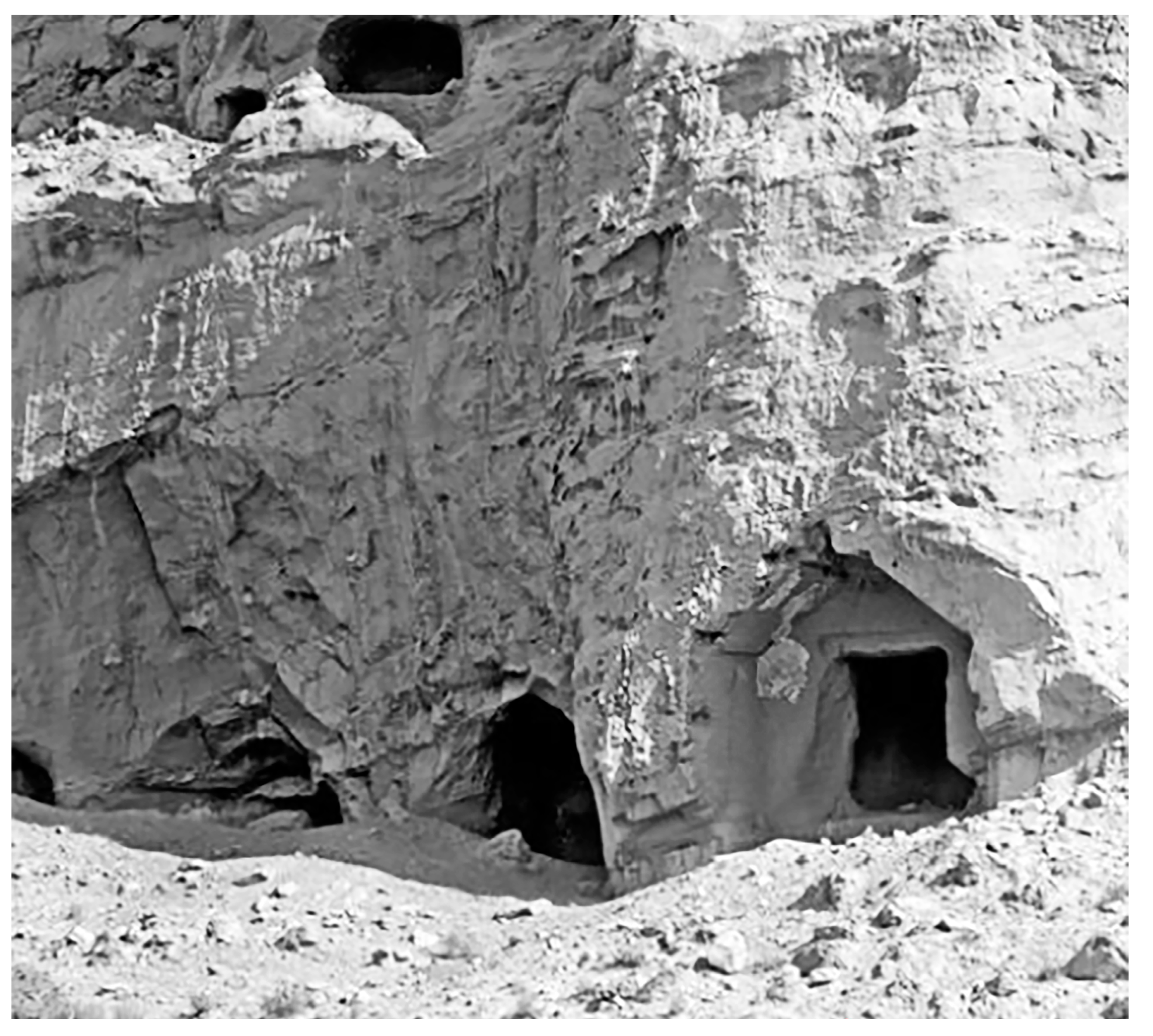
Figure 12). The niches carved in between the larger caves are still visible today and have, therefore, received an official number. These niches reveal similarities with the ones discussed above. Starting from the right in the photograph, Caves 55A and 57 are two niches carved on each side of Cave 56. Since symmetry is a paramount feature in the art and architecture of Kucha, these niches’ different size suggests they were not the result of a unified plan. The state of the cliff indicates that the two niches were carved after the antechambers were damaged. Further north, past the heavily damaged Cave 63, there are three niches: Cave 64A, 64B, and 64C. They were protected by the large wooden antechamber that extended from Cave 63 to Cave 65. These three niches are likewise different in size and shape. Cave 64A is a fully painted shallow cave. Cave 64B hosted a clay statue set against the rear wall. Cave 64C presents an opening on its left wall connecting it with Cave 64. Although the relative chronology of the above-mentioned niches remains to be ascertained, the asymmetry and difference in size and shape indicate the lack of a unified plan and suggest they were carved in different periods.
The identification of a pattern in the historical photographs of Kumtura—that is the carving of small niches after the collapse of larger caves—has led to the study of similar features that are still visible, and therefore measurable, in other rock monasteries.
A full discussion of the Simsim monastery is beyond the remit of this study.
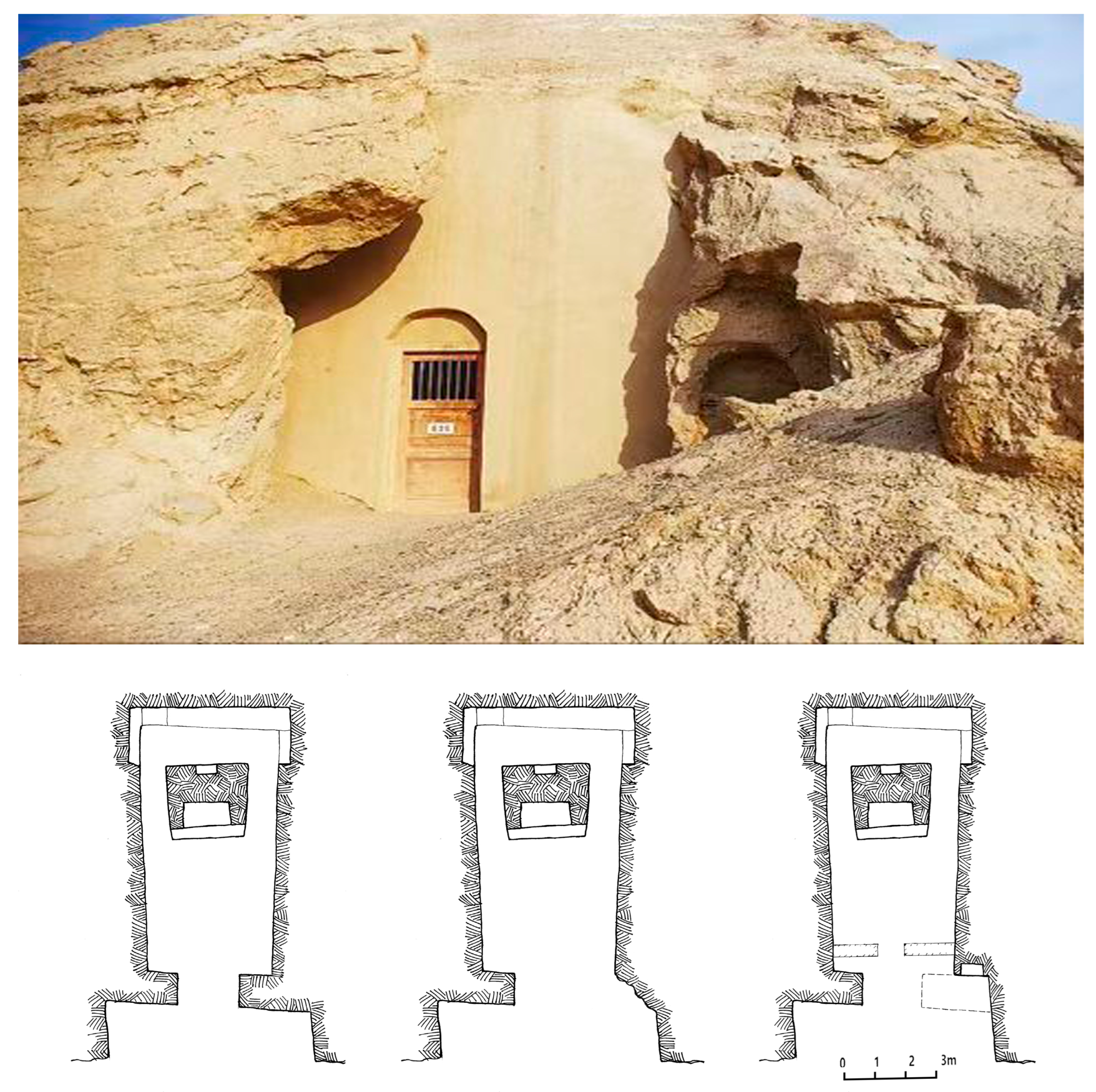
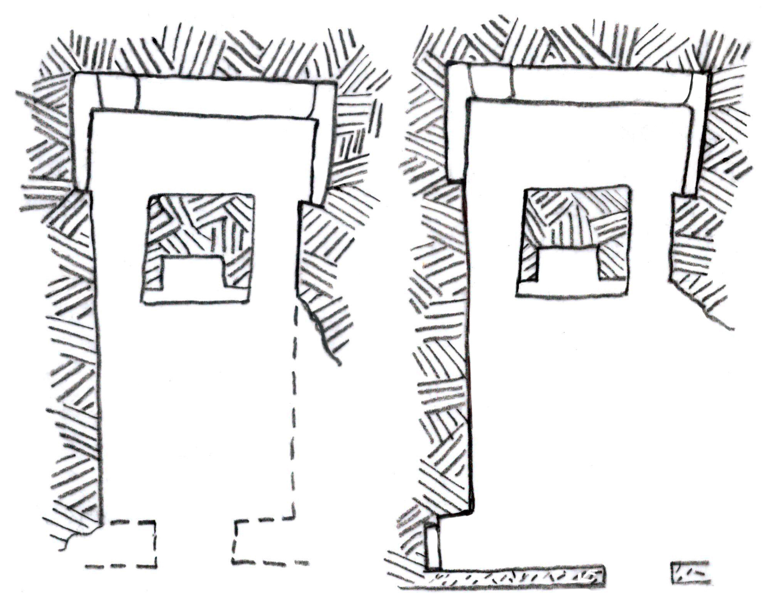
21 In this context, we only examine three caves: Caves 36, 32, and Cave 8. Cave 36 is a small niche carved next to the central pillar Cave 35, the largest of this type on the site, which is almost completely preserved except for its antechamber and a small section of the main chamber. The modern cement wall, meant to prevent further collapse, has foreshortened the internal space significantly. Cave 36 is a niche carved on a section of rock exposed by the collapse of the front part of Cave 35; again, the placement of this niche means that it could not have been part of the original cave (
Figure 13).
Simsim central pillar Cave 32A illustrates a similar situation. After the collapse of the cave, only the left and main wall of the main chamber and most of its rear areas remained intact. The location of the small niche on the left indicates it was undisputedly carved after the large collapse affecting the front part of the cave (
Figure 14).
Finally, Simsim Cave 8 is a small cave carved in a high position between Caves 7 and 9. The virtual reconstruction of the large antechamber of Cave 11 shows that this niche could have been carved in such a location only after this antechamber and that of Cave 7 to its left had collapsed (
Figure 15).
The construction of these small niches in Simsim parallels the scenario seen in Kumtura: after a collapse that damaged several caves, a small niche was carved in the newly exposed section of rock. A similar reaction to adversity also occurred in Kizil.
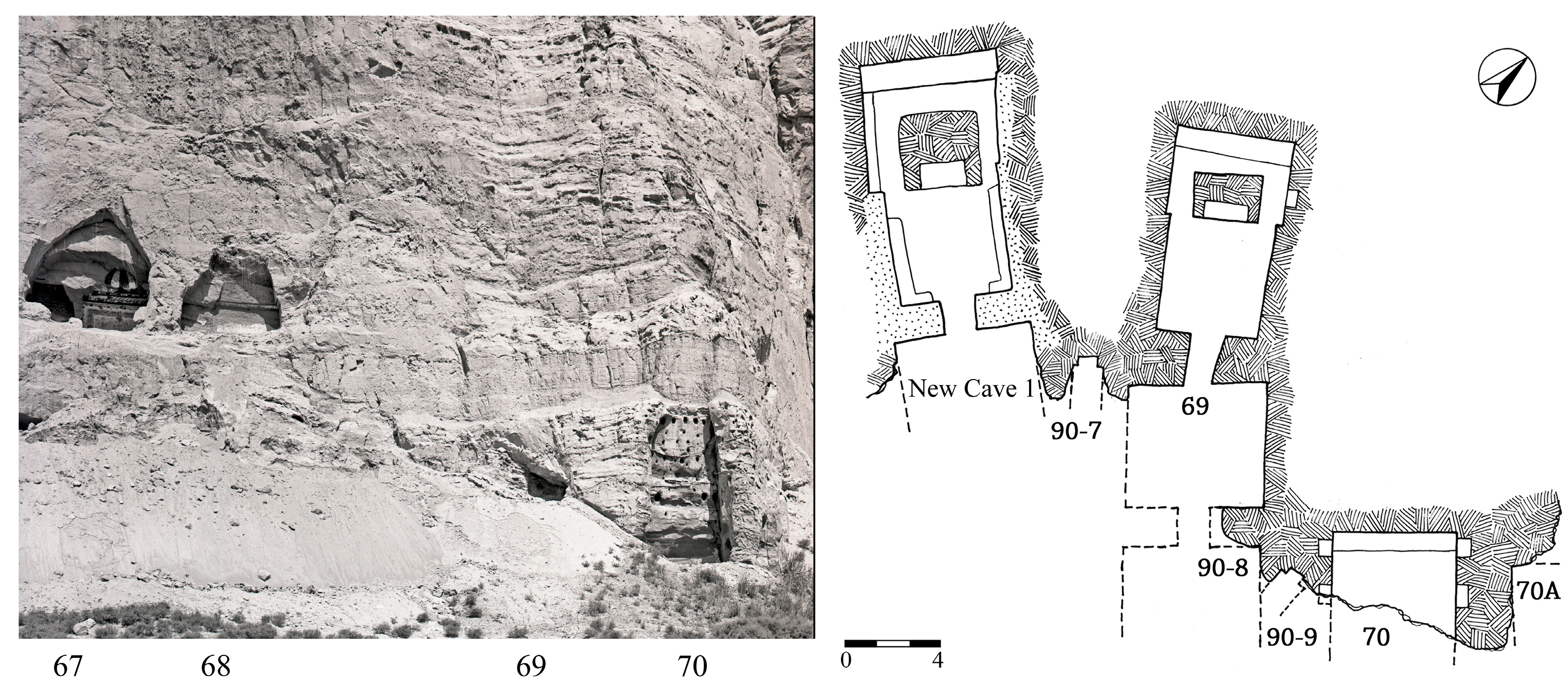
The tallest cliffs used to carve rock monasteries in Kucha are in Kizil. Large and deep scars in the rock are witnesses to the extent to which weathering has affected the site. The section of the cliff above New Cave 1 and Cave 69 shows marks of a large landslide that damaged both caves (
Figure 16). Originally, these were two square caves, here numbered New Cave 1[1] and 69[1]. After the collapse, niches Caves 90-7 and 90-9 were carved between New Cave 1 and Cave 69, and between Caves 69 and 70, respectively. Then, the two larger caves were repurposed into central pillar caves, New Cave 1[2] and Cave 69[2].
22 The niche’s similarity in size and structure, the fact that each niche had a recess for the installation of a small statue in the rear wall, and their being decorated with the same colors suggest the two niches were carved at the same time. The relative location of the two niches stipulates that they could have been carved only after the collapse of the section of the cliff comprising New Cave 1[1] and Cave 69[1]. Ensuing collapses sealed the caves and niches with debris that contributed to their preservation, since further deterioration would have wiped them out entirely.
23 These niches present us with a new situation. While, in Kumtura, some features seen a century ago cannot be presently seen, these were discovered in recent times and therefore unrecorded in historical photographs. Certainly, there are also some niches that were visible then and can still be seen now. Once more, this study requires a combination of fieldwork and close examination of historical photographs.
24We might summarize the above findings. Historical photographs have revealed significant data about crucial features in the rock monasteries that have been lost during the last century. Among them are niches, stairways, and installation marks of wooden balconies that were lost either to collapses and weathering or to restoration in modern times. Once the pattern of niches carved in segments that had been exposed following the collapse of earlier caves was pointed out, several other extant samples were identified. These were then studied, in order to gain a better understanding of the data seen in the historical photographs. The total number of these niches, comprising those seen in the photographs and those still in view is impressive, even without considering those likely lost.
25 The presence of these niches provides new data for the understanding of an activity that appears to have occurred in rock monasteries in the Kucha region: the carving of small niches following damage incurred in earlier larger caves. Another important piece of information concerns the position of the caves in Kumtura and Kizil on the cliff, much higher than the current appearance of the sites would indicate.
3. Features below the Present Surface in Kizil
A significant number of caves remain buried under the present ground level in Kizil. Identifying them and clearing them from debris would provide a more complete set of data from which to build a better understanding of the layout and development of the site.
Monastic cell Cave 42 and central pillar Cave 43 in Kizil District Four form a group. The two caves are presently slightly above ground level, but the historical photographs show that the group was at a higher position on the cliff. It was accessed via a quarter-turn stairway that opened through the right wall of the rock-carved antechamber shared by the two caves. The presence of this stairway can be ascertained from historical photos taken during the Turfan expeditions (
Figure 17).
26 The presence of the stairway indicates that the ground level in front of the caves was at a much lower position than at present. The installation marks of a cantilevered structure in front of the two caves, set up after the collapse of the rock-carved antechamber, also indicate that the caves were carved at a relatively high position in the cliff. The accumulation of debris at the foot of the cliff following the collapse of the antechamber has raised the ground level to just below the caves.
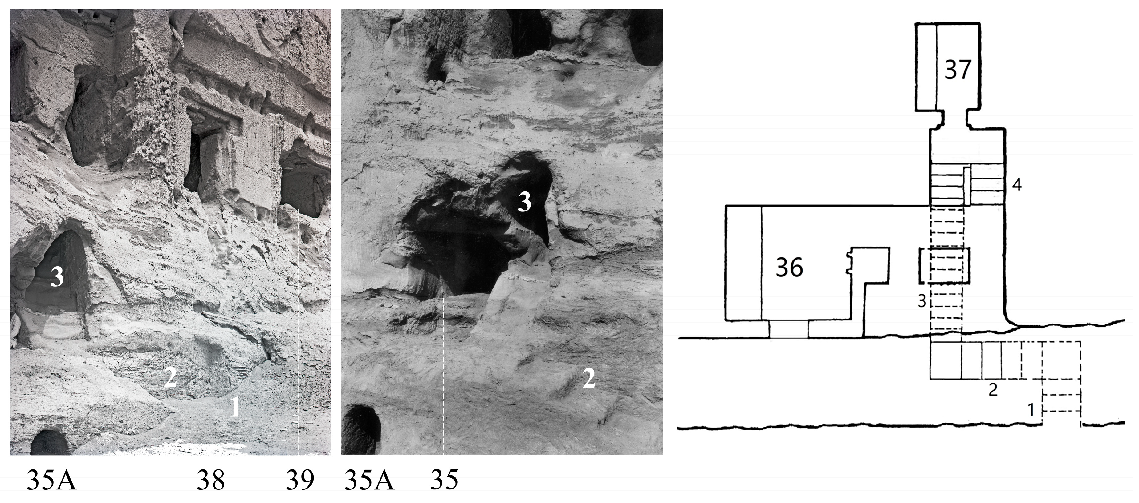
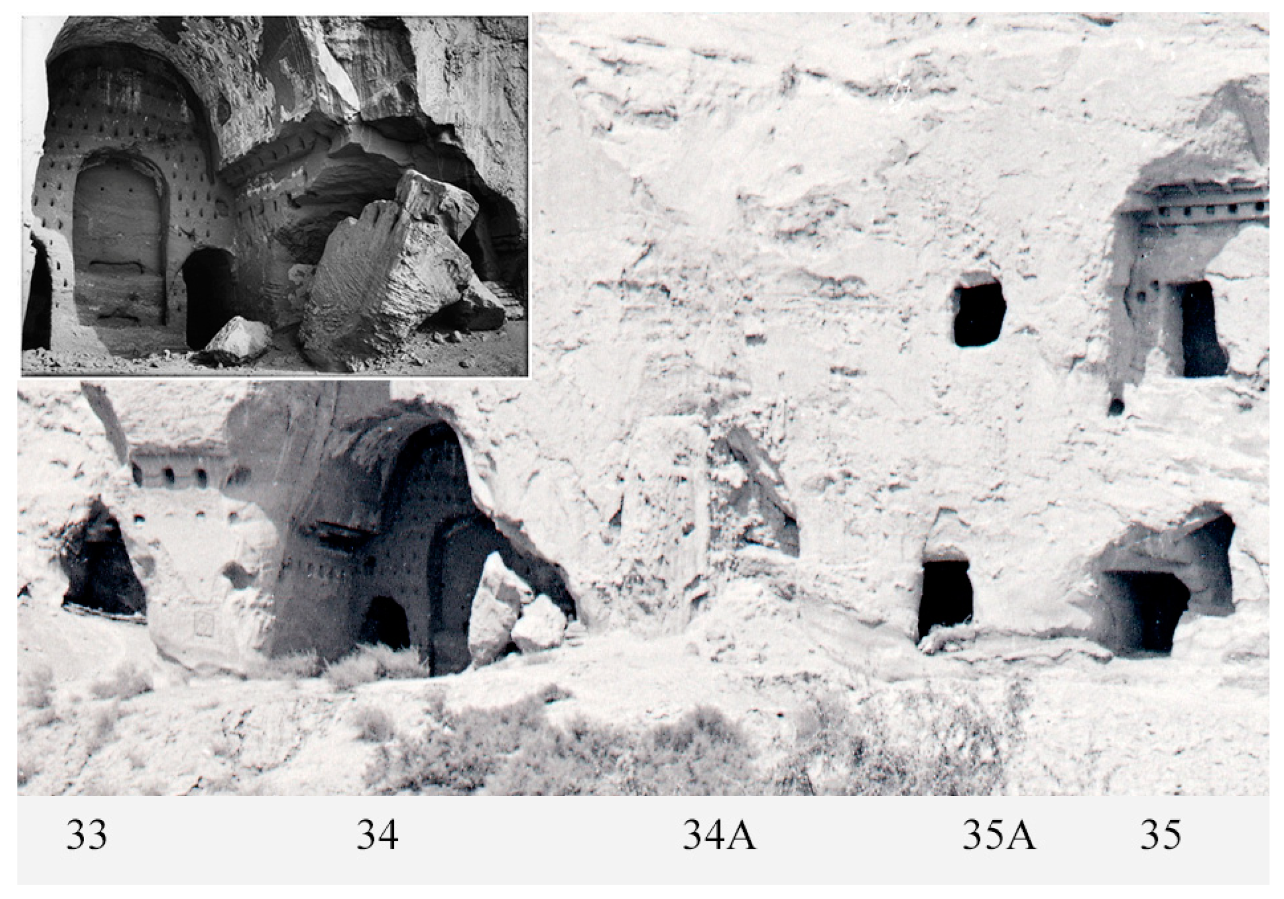
Further to the west, a few historical photos show part of a cave below and to the right of Cave 35, provisionally named Cave 35A (
Figure 18). Its size and shape suggest it was the corridor of a monastic cell.
27 Neither the historical photographs nor Grünwedel’s notes record whether there were other caves carved next to it. The location of this cave, more than five meters below the floor of Cave 35, leads to the conjecture, based on typology, that it might have been part of a row of caves, since in District Four monastic cells were typically part of groups and never carved in isolation.
28 Grünwedel drew the stairway leading to Cave 36, but he did not record the two lower flights of steps seen in the photographs.
29 This stairway was perhaps the most complex in design, with four flights of steps articulated in quarter turn and half turn. Planning and carving such a structure would certainly have required a considerable amount of labor and planning. The two lower parts of the stairway unearthed by the Germans, Cave 35A, and possibly other caves might still be preserved below the present surface. The photographs also help to recreate the original setting of Caves 38, 39, and 40, which were carved in a much higher position than presently seen.
Caves 33–35 formed a complex group that developed over time.
30 The extant rafter holes and floor joist holes indicate the presence of a cantilevered timber balcony. This implies that the group was carved in a relatively high position on the cliff, since a cantilevered wooden structure would have been useless for caves carved at ground level (
Figure 19). The high location of the group on the cliff means that the presence of caves below it cannot be excluded, especially considering the closeness of Cave 35A; a likeliness that deserves to be investigated by clearing the area in front of the cliff. Concerning the westernmost section of the cliff in Kizil (Guxi), there might be another row of caves below the present surface, approximately between Caves 32 and 43 (
Figure 20).
District Two consists of deposit caves of different shapes and sizes, randomly carved at various heights in the cliff. The lack of order strongly indicates that they were carved in different periods and for different purposes. The complex situation of this district is not conducive to deductions about the presence of other caves below the present floor level. Note, however, that the clearing of debris in the lower section of District Two in 1998 and District One in 1990 brought to light more than 30 previously unknown caves (
Xinjiang Qiuci Shiku Yanjiusuo 2000, pp. 95–111). Comparing the thick layer of debris in the historical photographs and the situation after clearing, one cannot but wonder how many caves might still be buried in District Two.
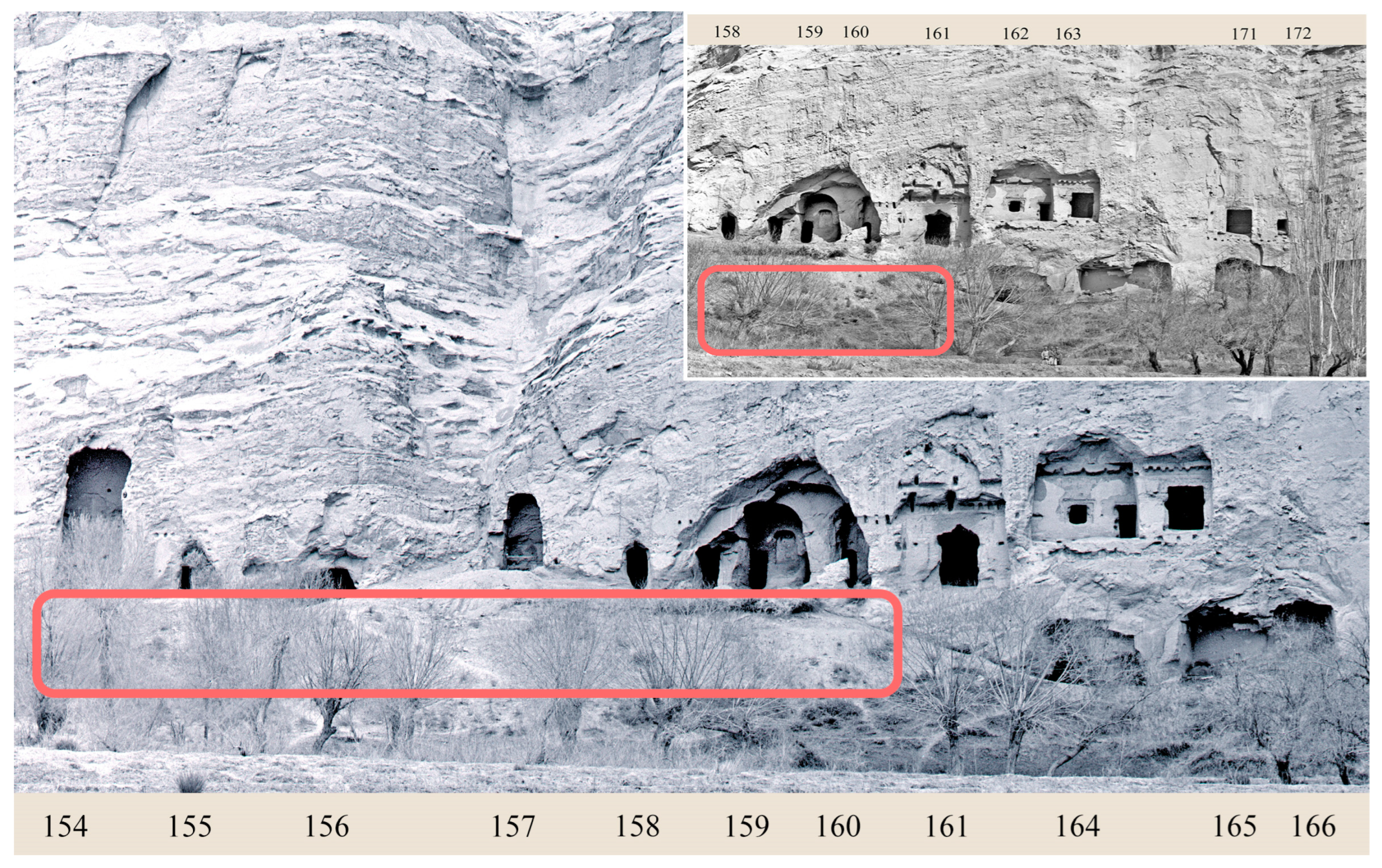
Several caves await excavation in District Three. Among these, two partially exposed caves are located at the southern end of Gudong (Caves 136, 137).
31 Cave 139A shows that other smaller caves could be carved below monumental image Cave 139 (
Figure 21). Similarly, there is a presently unnumbered cave partially emerging from the ground to the left of monumental image Cave 154. Continuing eastwards, Caves 164–170, carved below Caves 163 and 171–172, suggest that other caves might also be buried under the thick stratum of unexcavated debris in the area between Caves 154 and 164 (
Figure 22).
32In recent years, a new cave, Cave 119A, was discovered in Gunei (District Six) in front of Cave 119 (
Xinjiang Qiuci Shiku Yanjiusuo 2001, pp. 47–64). Other caves were identified during fieldwork in a high location on the cliff; they were reached through the much-damaged rock-carved stairway, Cave 113.
33 On the west cliff of Gunei, an intriguing cave was cleared of debris at the time of the German Turfan Expedition; their written record is quite puzzling, since there are little remains of a cave south of Cave 92, provisionally called Cave 92A, that might be the one recorded by them.
34Limiting our attention to Kizil, we have indicated that several caves emerging from the present ground level are awaiting excavation and that others might have been carved in the lower reaches of the cliff, presently covered with debris. This conjecture is based on the combined use of historical photographs, in situ observations, the rationale behind the concept of districts and group types, the fact that cantilevered structures were used for the restoration of caves carved in a higher position on the cliff, and the recollection of people witnessing their uncovering in previous decades.
These new data further improve our understanding of the site. The caves in the cliff facing the Muzart River were carved in a higher location than appears today. Those caves that are still visible in Kizil appear to follow a pattern whereby caves were carved into the lower reaches of the cliff first. Only when the lower sections of the cliff were used up were caves carved in suitable layers of rock higher on the cliff. This means that it is possible that the earliest caves at the site are still hidden below the present ground level, awaiting excavation.
35 4. Rescue of Information about Damaged Caves and Paintings
The unceasing deterioration of the cliff has, in some cases, made it difficult to discriminate between man-made caves and natural formations. Historical photographs can assist us in these cases. We look at a few examples from Kizil.
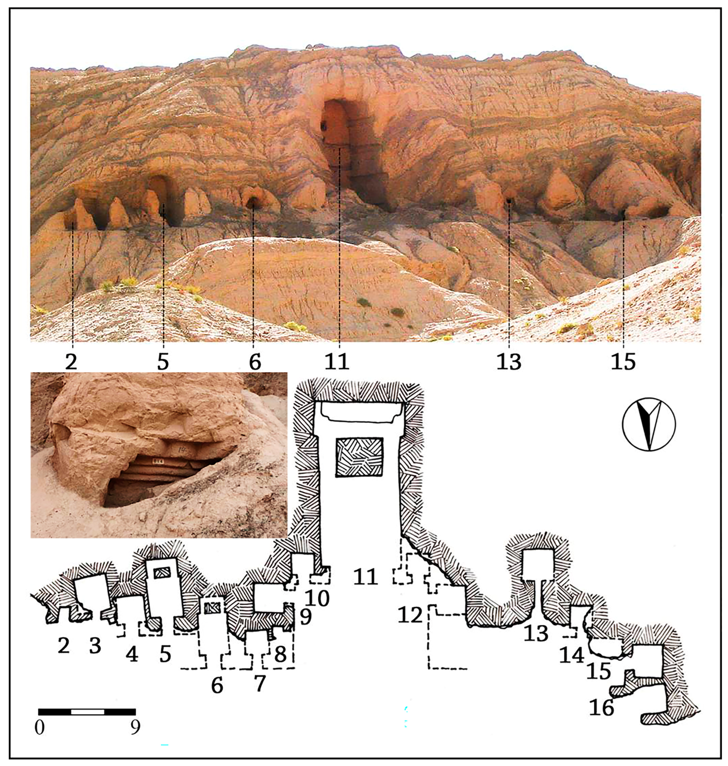
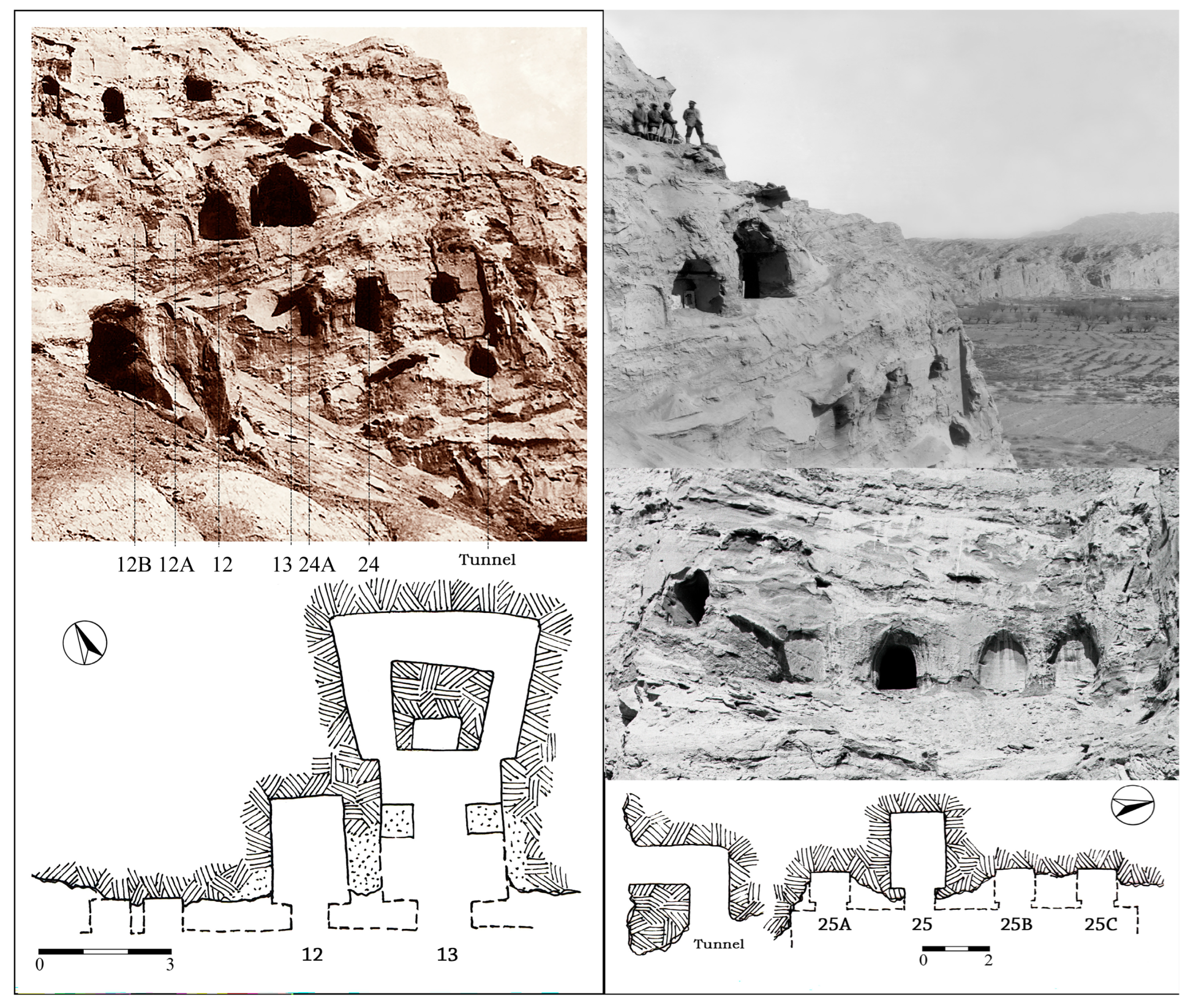
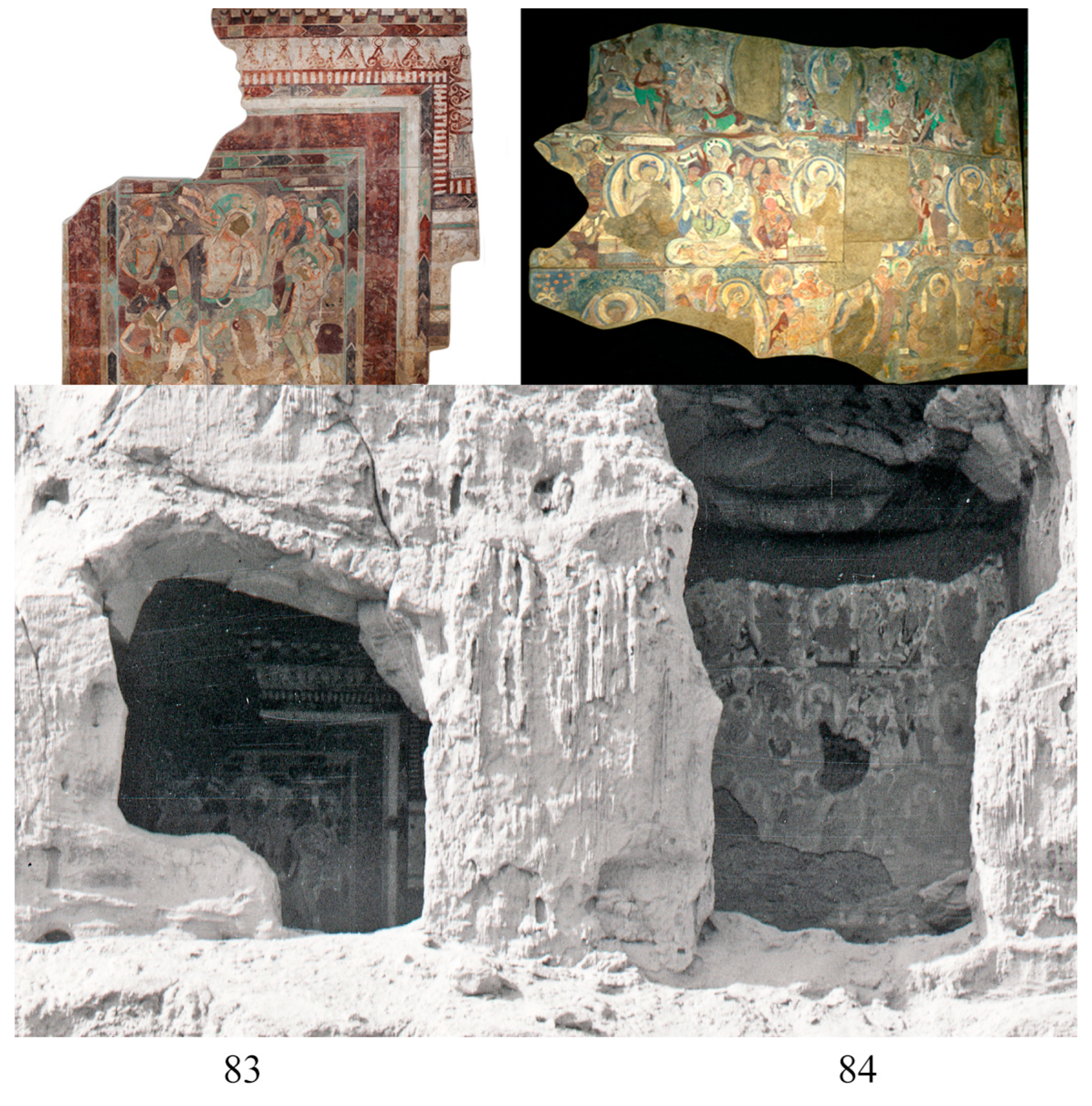
The cave type that has suffered the most damage in Kizil is the small individual meditation cell. We can see this in the group comprising Caves 12 and 13, and Cave 24. This group also included several meditation cells: two on the left of Cave 12 are still visible today, as well as one on the left of the monastic cell Cave 24. The latter is a much-damaged feature that can be identified as a meditation cell on the basis of the historical photographs (
Figure 23). The rear wall of the large antechamber of Cave 24 can be clearly seen in the photograph and shows that the tunnel used to reach meditation cells Caves 25, 25A, 25B, 25C started from within the antechamber of Cave 24, indicating that the four meditation cells were part of the same complex group. Historical photographs have been crucial for gaining a thorough understanding of this group, which included at least seven meditation cells.
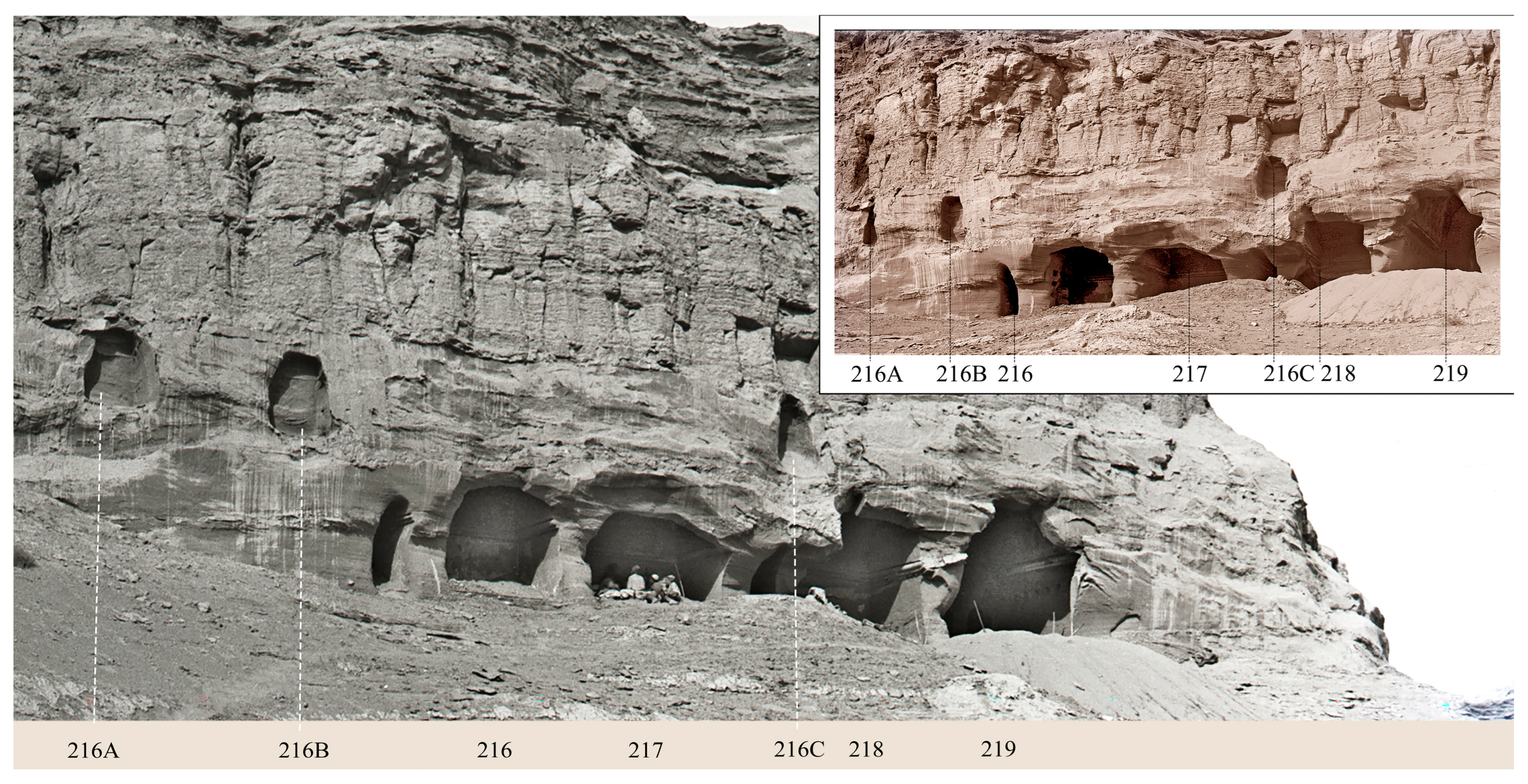
The group comprising Caves 216–218 in Kizil also included three meditation cells, respectively Caves 216A, B, and C, carved above the larger caves (
Figure 24). The three caves are presently damaged to the point where it has become almost impossible to identify whether they were natural formations of the rock or man-made structures, but the latter hypothesis can be confirmed on the basis of the historical photographs that clearly show straight contours.
36Many of the caves in Kucha were carved in high positions on the vertical cliffs, therefore needing stairways leading to them, to give a small taste of their original situation. There were certainly more stairways than the few damaged or heavily restored samples we can still see.
37 The extant samples help us familiarize ourselves with the different types of inner stairways used: straight (Simsim, leading to Caves 48–50), quarter turn (most common, such as the one leading to Kumtura Caves 10–11
Figure 7 and Kizil Caves 42–43
Figure 17), half turn (Kizil below Cave 38,
Figure 18), curved stairways (Kumtura, leading to the Five Joined Caves). In addition, wooden ladders were needed to climb cantilevered structures. The study of these structures can help individuate similar remains and better understand those recorded in historical photographs. A thorough and systematic collection of data concerning these stairways and their study will clarify the way in which caves carved in high positions on the cliffs were reached, thus improving our understanding of the way the site was utilized.
Historical photographs can also be used to reconstruct decor. Natural and human-made damage led to the loss of much statuary and paintings. Large sections of the paintings were detached and are now preserved in various museums. To facilitate their removal and transportation, they were sawn into relatively small sections, but their reassembly has not always been successful. Problems range from the attribution of the paintings to a specific cave, the position within it, and the sequence of scenes. Several of these problems can be solved by referring to historical photographs. Kumtura Cave 12, mentioned above, is a typical case. In the reassembly of the paintings on the rear wall of the main chamber, unrelated pieces were joined together, giving a distorted reconstruction of the iconography. This fact was pointed out by comparing the reconstruction with the historical photographs taken before the painting was detached (
Liu 2017).
Historical photographs taken from within the caves have been used for the reconstruction of paintings. Shots taken from a distance can also be used. A high-definition historical photograph allows for enlargements that show the paintings within the caves through doors and windows. Although the resolution is insufficient for iconographic and stylistic analysis, the images unarguably show the original layout of the paintings and can be used to verify the accuracy of the reconstructions (
Figure 25). In other cases, photographs show the paintings in the antechambers, a largely understudied topic—some of these antechambers have subsequently collapsed (
Figure 26).
38 Photos were taken in the antechamber of Kizil Cave 76, which was almost completely intact at the time of the Turfan expedition. These photographs were meant to show the relative position of the unearthed relics, but they show the wall in the background where part of the paintings described by Grünwedel can be seen. The antechamber of this cave has now collapsed, but luckily part of the paintings can be seen in the photographs.
39Finally, historical photographs offer a term of comparison to assess the deterioration of wall paintings over the last century, a precious term of comparison, not only for the study of the site, but also for eventual restoration activities.
5. Lessons Learned from the Past
Cliffs are in a constant state of erosion, caused by weathering and earthquakes, as well as human activity. When monasteries were in use, damaged caves were promptly repaired, and no effort was spared in order to keep the monastery operational. Depending on the severity of the damage, different restoration techniques were used. Their marks were more visible a century ago and recorded in photographs. They deserve to be thoroughly inventoried and seriously studied. They range from small repairs, such as the application of new plaster in place of fallen plaster
40 and the filling of large and smaller cracks in the rock,
41 to large interventions, such as the excavation of a new cave through the rear wall of an earlier cave that had incurred heavy damage (Kizil Cave 69,
Figure 16), the rebuilding of walls and ceiling with mudbricks and wooden beams (Kumtura North Monastery Cave 63), the setting up of cantilevered timber balconies for caves located in a high position (
Figure 22), or light porches for caves carved next to the ground (
Figure 4).
By keeping the caves in use, the cliff was continuously stabilized. After the abandonment of the sites, the cliff continued to deteriorate and debris accumulated in the lower reaches, covering and protecting the lower caves from further erosion and collapses. In the last century, debris in front of the cliffs was cleared, in order to study the caves, an action that often caused further damage. The historical, photographic, and written records bear witness to the state of the cliff before or at the time of the clearing. In addition, photographs show that after clearing, even the clearing carried out in recent decades, the degeneration of the cliff sped up. A clear example is Kizil Cave 76. The photographs of the German explorers show that the cave was almost completely buried under debris.
42 The 1906 excavation was also well documented with photographs and drawings by Grünwedel (
Grünwedel 1912, pp. 87–88). The antechamber was almost completely preserved, with parts of its decor in situ. A few decades later the antechamber collapsed. To keep the cave from collapsing further, in the 1970s, the front wall of the main chamber was reinforced with concrete; concrete was poured into the floor of the original antechamber, leveling it with the floor of the main chamber and connecting it with the gangway linking it with the caves to its right and left. In this way, the three steps between the antechamber and the main chamber recorded by Grünwedel cannot be seen, thus giving a distorted understanding of the cave. Further impairment was caused by the concrete cantilevered stairway built to reach the caves at this upper level, making it impossible to reconstruct the way the caves were reached at the time of use. In addition to this, the gravitational weight of gangways and stairways puts a constant strain on the cliff.
43 Though many crucial features have been lost because of further weathering and restoration, without a thorough scrutiny of texts, drawings, and photos, Cave 76 would be wrongly interpreted.
Caves 2–6 in Kizil are another telling example. Historical photographs show that the upper section of the caves had already partly collapsed by the beginning of the previous century.
44 The plan of the cave drawn by Grünwedel after it was cleared encompassed a large section of the antechamber shared by Caves 2 and 3, as well as of the individual antechamber of central pillar Cave 4 (
Grünwedel 1912, p. 44, fig. 87). These caves were again cleared in the 1980s as part of the activities leading to the publication of an archaeological report (
Beijing Da Xue Kaoguxue Xi, Kezi’er Qianfuodong Wenwu Baoguansuo 1997). The maps, drawn more than a decade before publication, show that the front section of the caves had been lost and that concrete walls had already been set up to impede further collapses, a response to the deterioration that had sped up since the time of the Turfan Expedition (
Beijing Da Xue Kaoguxue Xi, Kezi’er Qianfuodong Wenwu Baoguansuo 1997, p. 13, fig. 10). Deterioration was further triggered by the clearing at the time of the report and is presently ongoing.
This state of affairs is especially common in most rock monasteries of Kucha and across the Xinjiang-Gansu area, due to the geological makeup of the cliffs, which are mainly composed of mudstone, sandstone, and conglomerate layers. The stability reached with the progressive accumulation of debris in front of the cliffs is compromised by debris removal. A comparison between historical photographs and the present state of the cliffs indicates that damage accelerates after the debris are removed, while it is slower in areas still covered by debris. An understanding of the damage ensuing from the clearing of the caves would call for a slowing down of interventions, especially those not essential for the upkeep of the cliff and monuments. In the future, when debris need to be removed, the stabilization of the cliff must be promptly addressed.
45Modern restoration ought to take into consideration the original layout of the monastery, especially the way caves were connected to form groups, the direction from which these groups were accessed, the empty spaces in front of the caves, and the surroundings. In one of the above examples, Kizil Caves 42–43, the original stairway ascertained on the basis of historical photographs gave access to the caves from the right. The modern concrete stairway, instead, reaches the cave from the left. Similarly, the partially preserved stairway leading to Caves 110–111 was carved on the left of the group, while the modern cement stairway has been constructed on the right. A bulky concrete stairway has been constructed to reach the largest monumental cave in Kizil, Cave 47. Apart from being displeasing to the eye, the structure misinterprets the original plan. The monumental cave was carved on top of a 20 m tall vertical section of the cliff (
Figure 15). This section of the cliff was left “empty”, that is, no caves were carved into it, because it was meant as a large pedestal for the colossal Buddha within the cave. Apart from being unnecessary—the cave can be accessed by walking from the east, as in the past—the modern staircase exerts constant tensile stress on the cliff.
The study of the layout of the monasteries in Kucha is just beginning, since past studies mainly focused on individual caves. There is a strong need to understand the plan of the whole rock monastery, in addition to the above-mentioned issues, before any large-scale restoration takes place. The rationale behind recent interventions seems aimed to satisfy the needs of the tourist industry, often disregarding the original inner logic of the monastery layout. Heavy interventions over the last few decades have defiled the site, taking away from its pristine beauty and sacredness, and misleading tourists and scholars alike (
Figure 26).
Historical materials and techniques should also be considered, since in many cases they have survived the test of time or at least did not inflict further damage.
46 Money was not spared for the construction and also for the restoration of the caves. The restoration relied on good quality wood, carefully chosen clay for plaster and sculptures, and gypsum for the floor. Skilled artists used expensive natural pigments and complicated techniques for the paintings (
Taniguchi 2022). The upkeeping of the caves required large amounts of work and resources.
The rock monasteries were inserted in stunning landscape locations. Their mingling with nature greatly contributed to the religious experience the monastery was intended to evoke in residents and visitors alike. At the beginning of this paper, the pitiful present state of Kumtura was described. The large valley in front of the cliffs of Kizil was a place of pristine beauty. Although part of the land in front of the Kizil caves was given to agriculture, as informed by the historical photographs, the extent and speed of the damage inflicted on the site and the landscape since the Kizil Cave Institute has been set up have no precedent in the biography of the site.
6. Final Remarks
Available for over a century, the historical photographs of the rock monasteries of Kucha have been rarely used in academic research. In numerous cases, however, the photographs record features that have since been lost, and therefore they should be regarded as first-hand material. Fieldwork and in situ observations remain the primary research tool and complement each other. To reach a more comprehensive understanding of these rock monasteries, the method proposed in this paper is a combination of the two activities. Historical photographs not only reveal lost features but in doing so could trigger a new understanding of presently visible ones. The analysis of historical photographs has a great value for assessing certain architectural features otherwise difficult to appraise. Among these are the identification of much-damaged caves, the rediscovery of niches that collapsed or were buried in the last century, and the location and typology of inner stairways. Moreover, at times, they record statuary and paintings subsequently lost.
Rock monasteries had more caves and buildings than presently seen, a fact that is frequently forgotten when carrying out research. Damage and loss of information occurred at the sites over the centuries, but this has accelerated in recent times, comprising much human-caused damage. Historical photographs reveal the state of the monasteries close to how they appeared several centuries ago.
This study has shown that in the lower section of the cliffs in Kumtura North Monastery, there were no other caves except those recorded in historical photographs. Conversely, in Kizil, thick strata of debris still cover the lower section of the cliff. The sections cleared in several campaigns over the last hundred and more years revealed the presence of a large number of caves and surface structures. Historical photographs show some caves that have been subsequently lost or covered by debris. These data, considered together with the caves partially emerging from the ground and others that can be conjectured on solid ground, present a strong case indicating that, in Kizil, there are presently a considerable number of unseen archaeological features that might reveal crucial aspects of the early life of the site.
Connective architecture was more common than might be acknowledged through present-day surveys. While some of the rock-made structures can still be seen, in spite of having suffered damage, the wooden ones have been completely lost. Nonetheless, reconstruction can be attempted on the basis of the installation marks on the cliff. The recent work to consolidate the cliffs and the reparations of caves has modified the outer facade of the cliff and covered many features (
Figure 27). Historical photographs have been a crucial material for the accurate study of these features. The lack of attention given to these documents has led to the “invention” of new ways to connect the caves, disregarding the original ones. Understanding how the rock monastery was in the past will help carry out a more accurate restoration. In addition, one also has the opportunity to reassess the original landscape and the visual impact of and from the caves.
Marks of reparation carried out during the period of monastic occupation are seen in all the rock monasteries of Kucha. The scale of the repairs is impressive, denoting the determination to keep the site in use in the face of continuous damage. Apart from the initial financial and human resource investment, a substantial amount of funds were made available for the upkeep of the rock monasteries. In the larger ones, we can imagine the noise of percussion tools and wood saw cutting of beams and planks; indeed, workers would have continued to tend these sites for centuries and the monasteries can hardly be considered silent places conducive to meditation.
Last but not least, we take up again the issue discussed at the beginning of this paper. The presence of many niches carved in sections of the rock exposed by the collapse of earlier caves shown by the historical photographs has attracted attention to similar extant cases. We have pointed out a recurring pattern of carving niches after earlier large caves suffered damage, a fact that deserves some explanation. This peculiar modus operandi allows us to glimpse a minor religious practice taking place within the rock monasteries. The carving of these niches might be interpreted either as an intercession to avert further collapse or as a reparative action aimed at making amends for the carelessness in the choice of the location that brought the collapse of the cave. This paper intends to do the same: to ask the Buddha to prevent the rock monasteries from incurring further damage and to ask competent authorities to carry out sensible restoration, preserving them for future generations to see.
