


Prehistoric Cult Sites along the Desert Roads

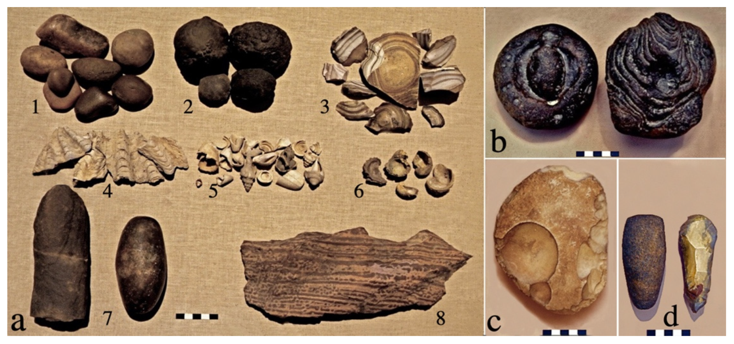
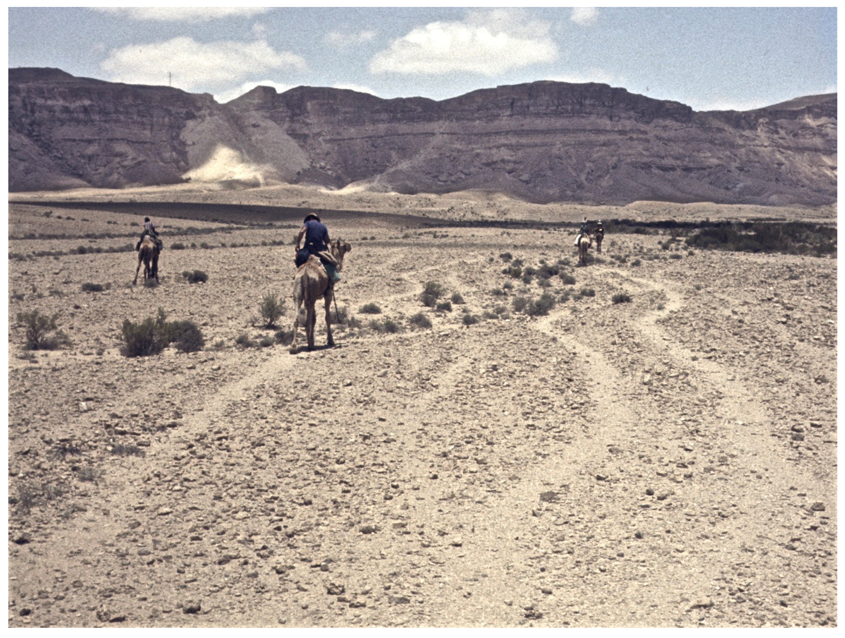
Abstract
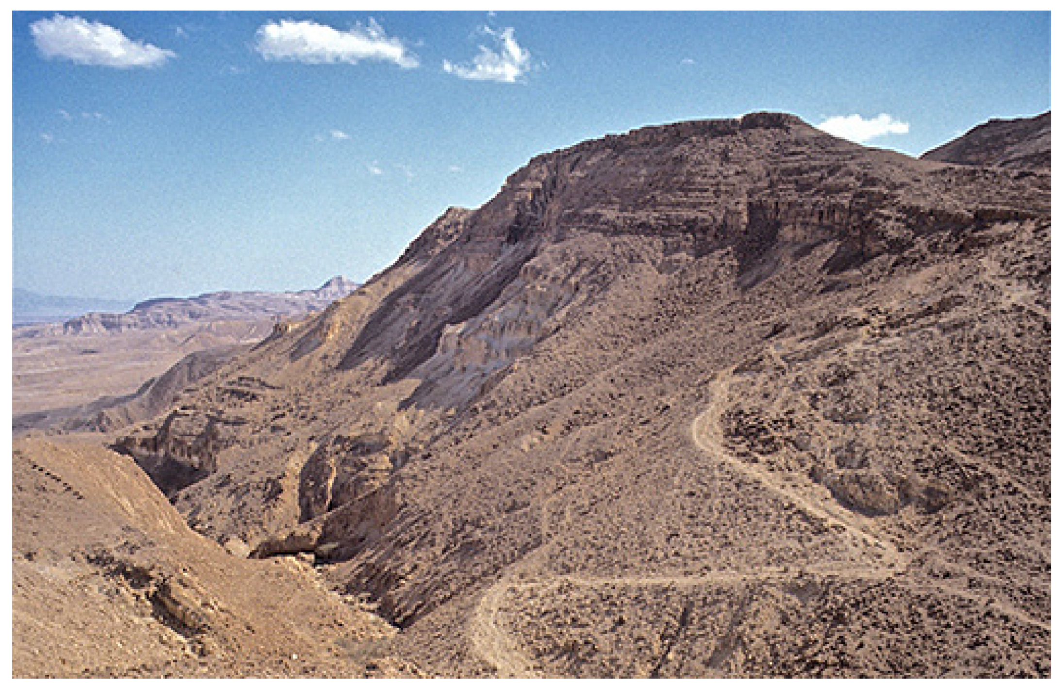
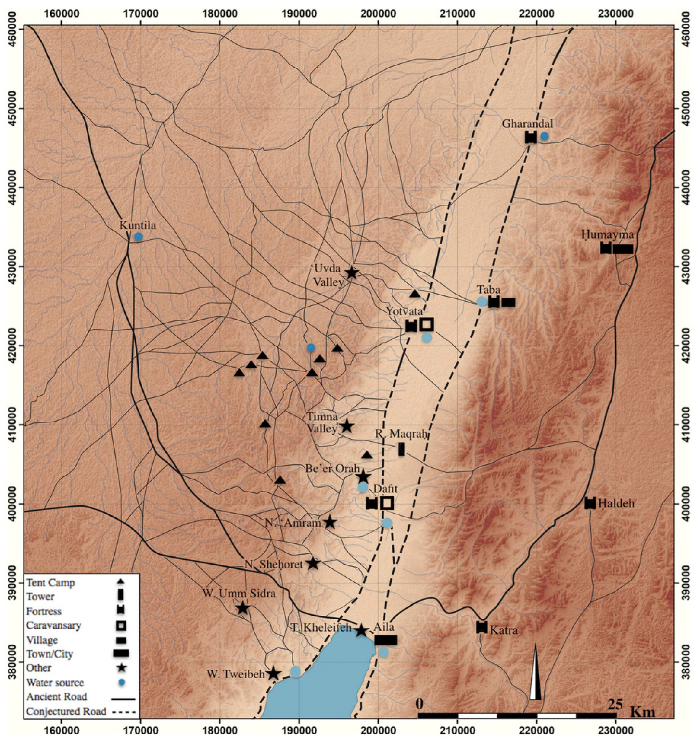
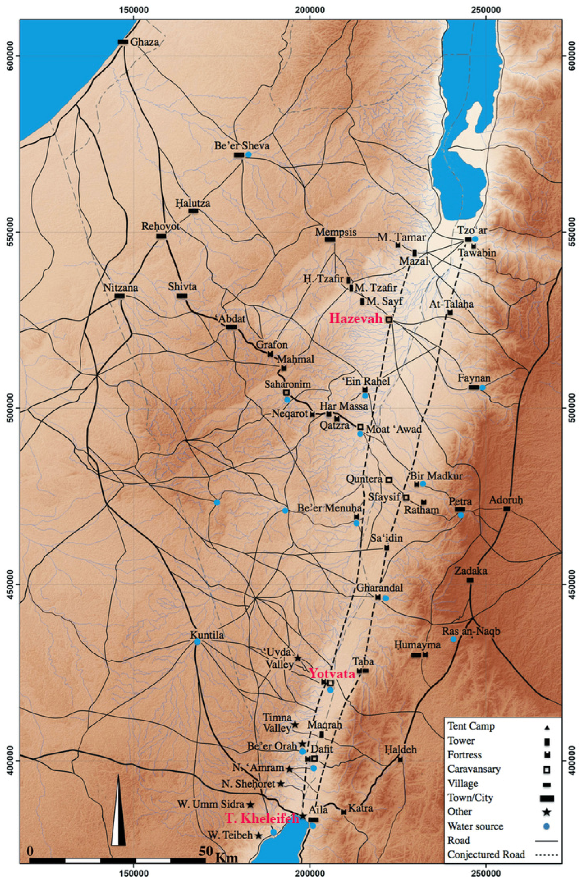
:1. Introduction: The Desert Ancient Roads
2. The Cult Sites
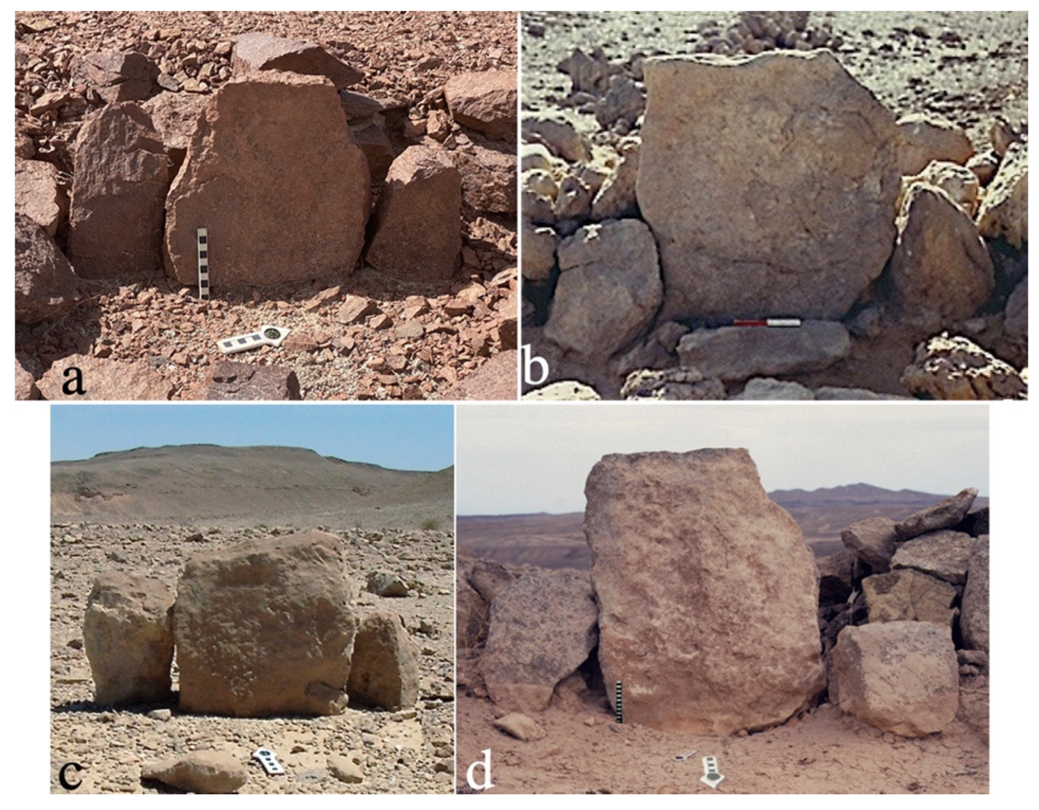
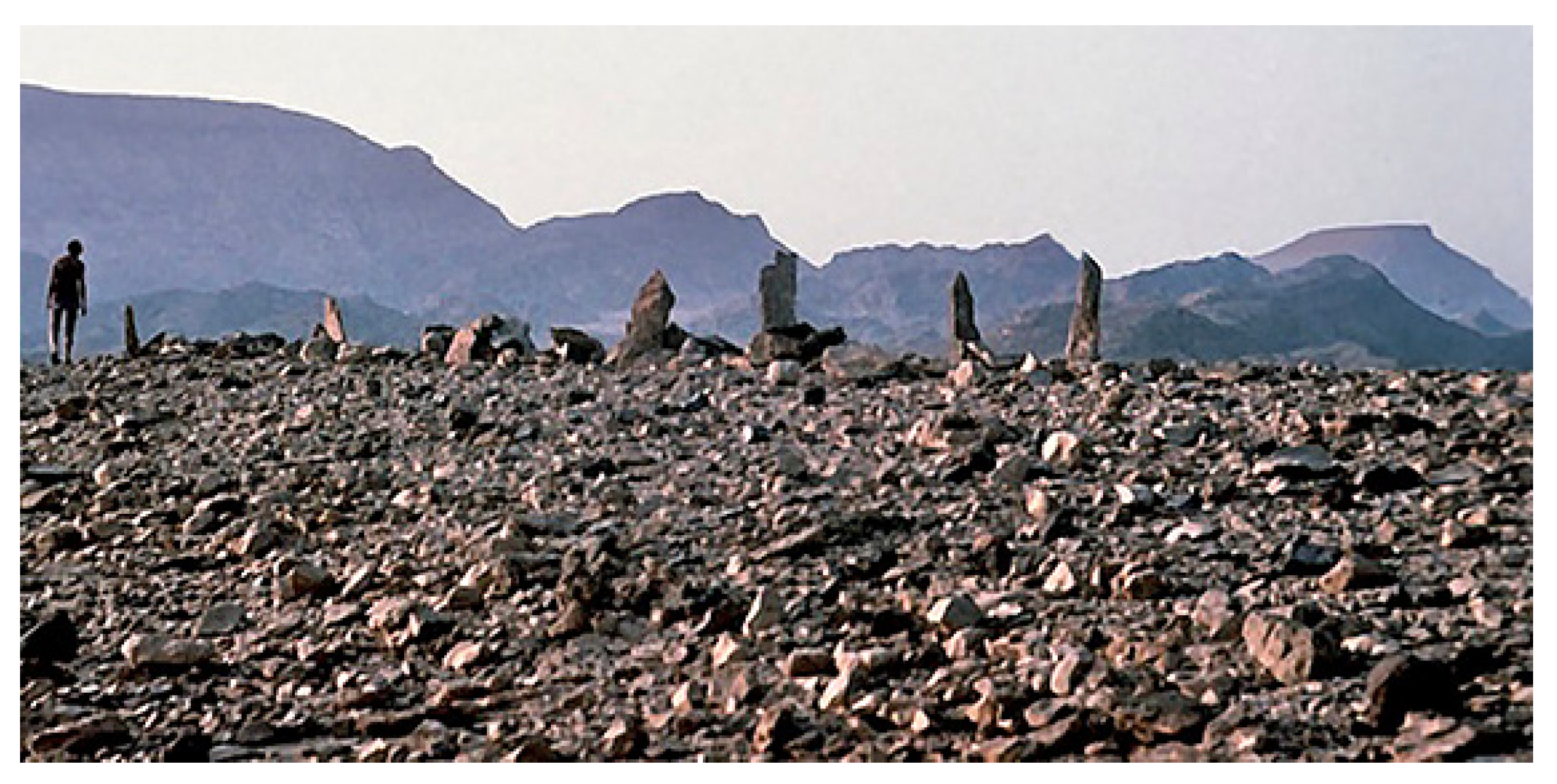
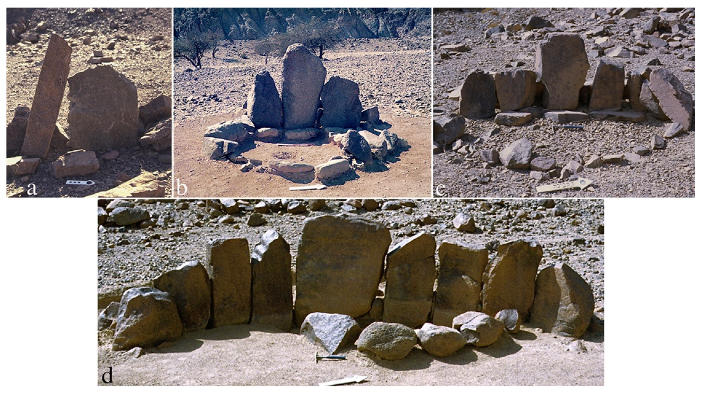
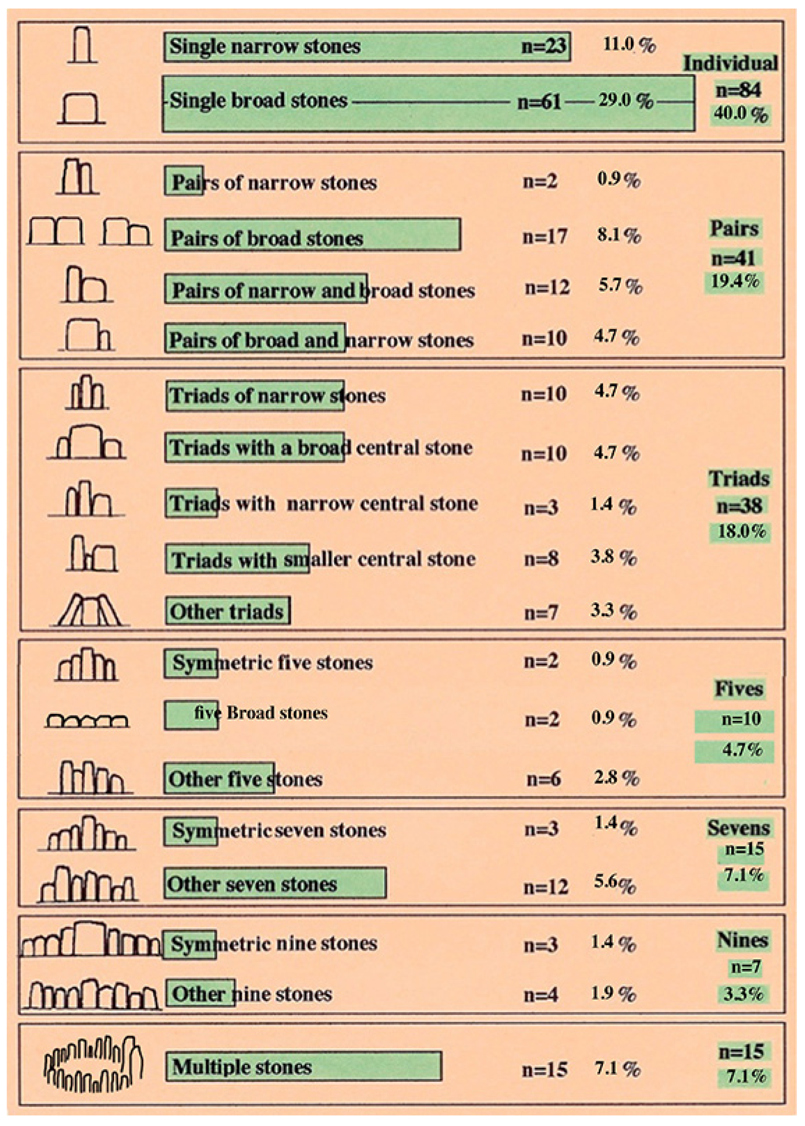
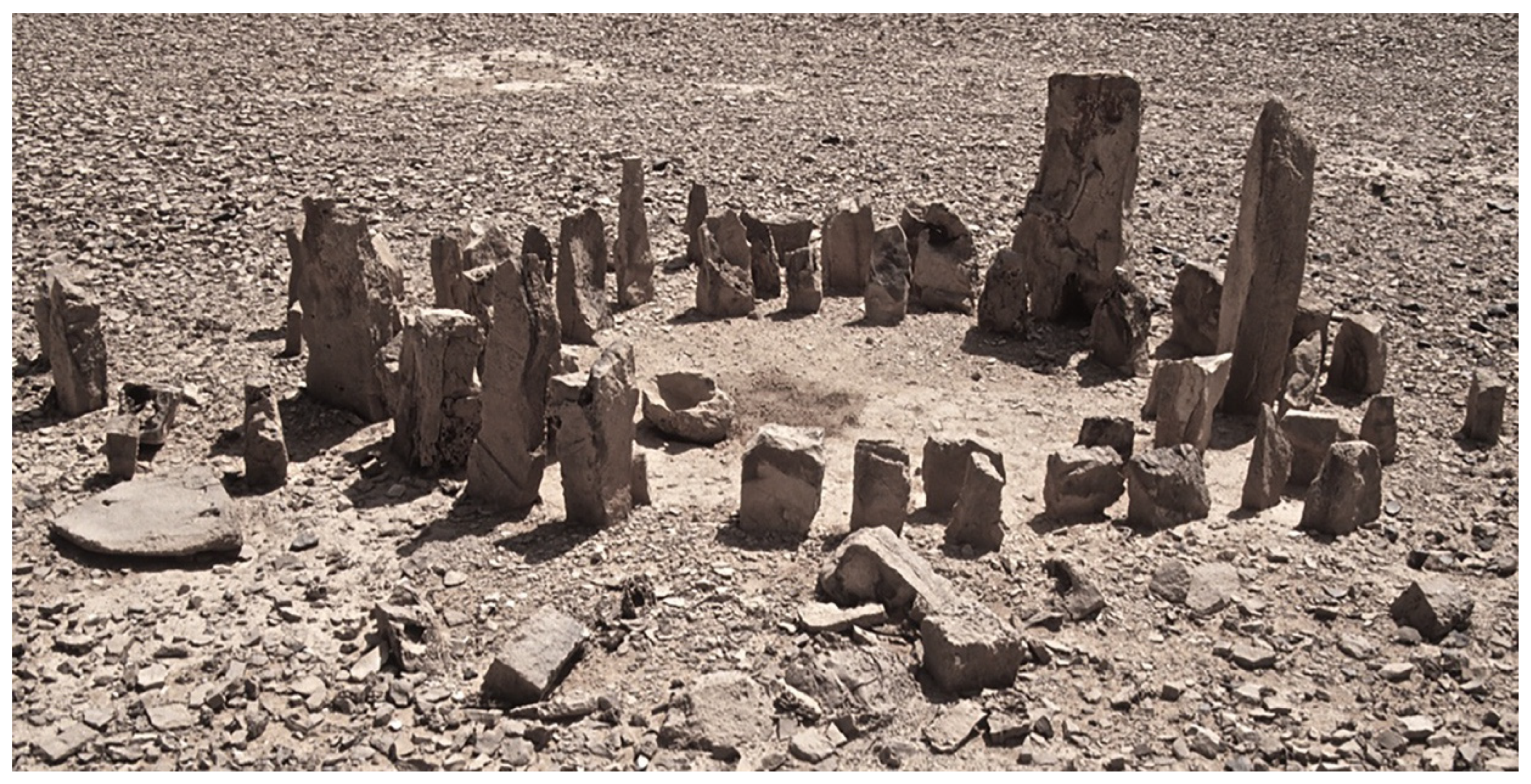
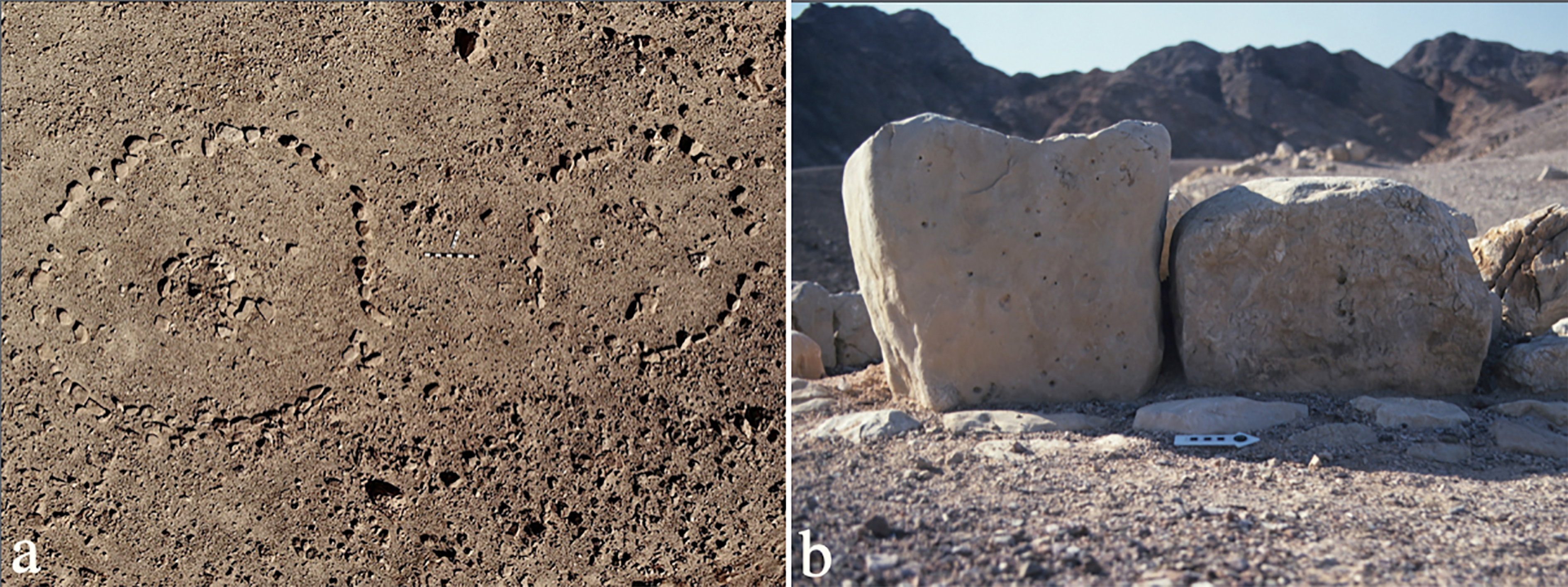
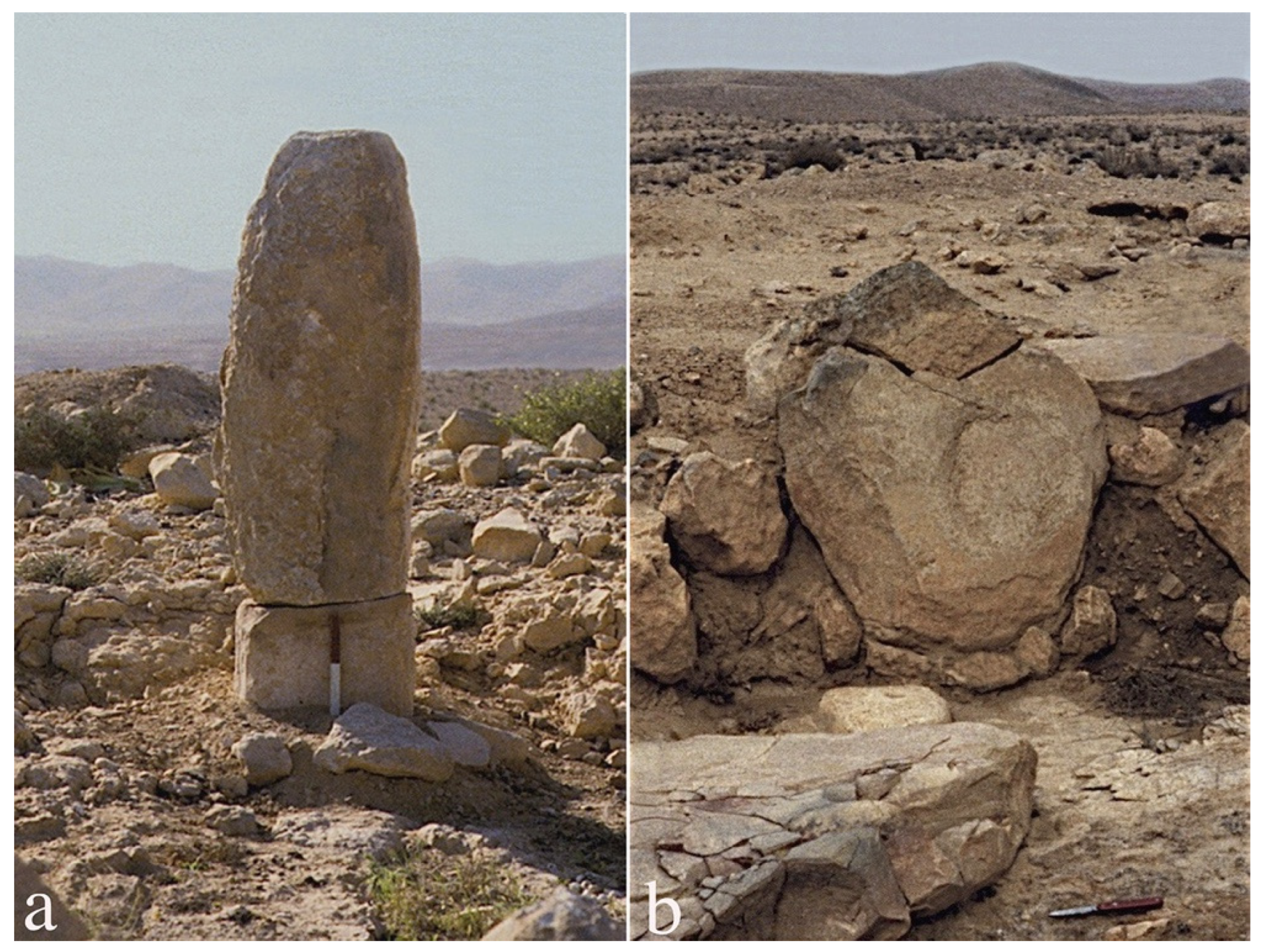
3. Maṣṣeboth


4. Open-Air Sanctuaries
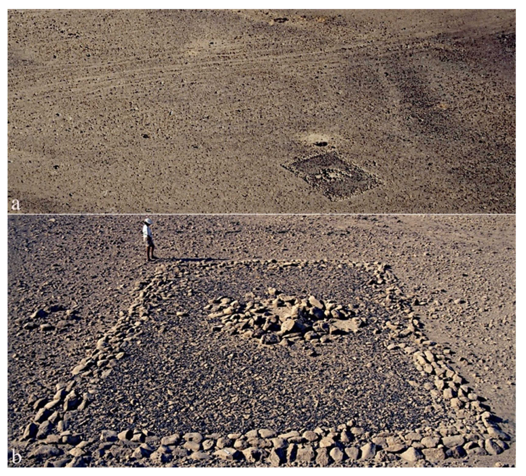


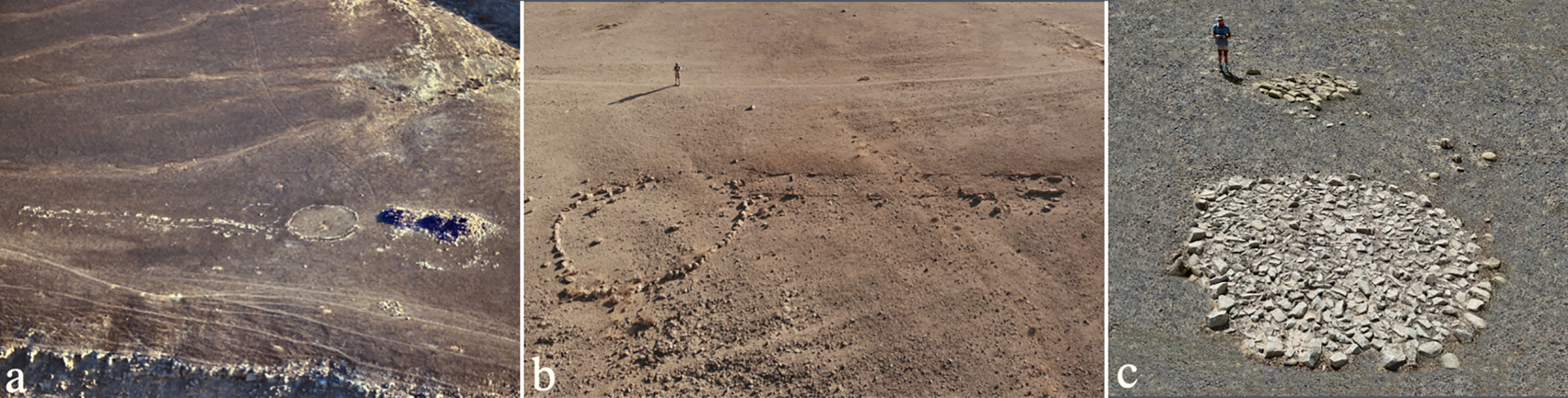
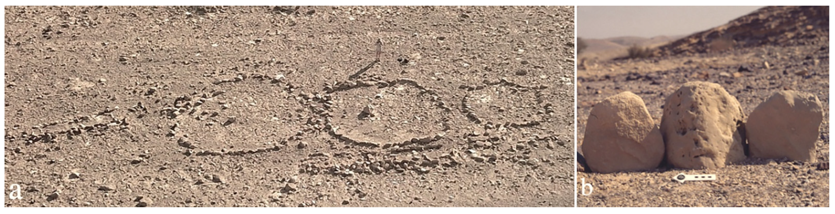
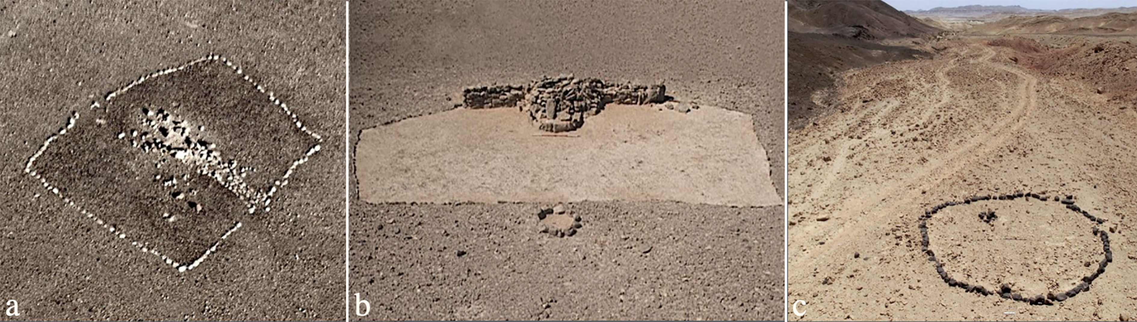
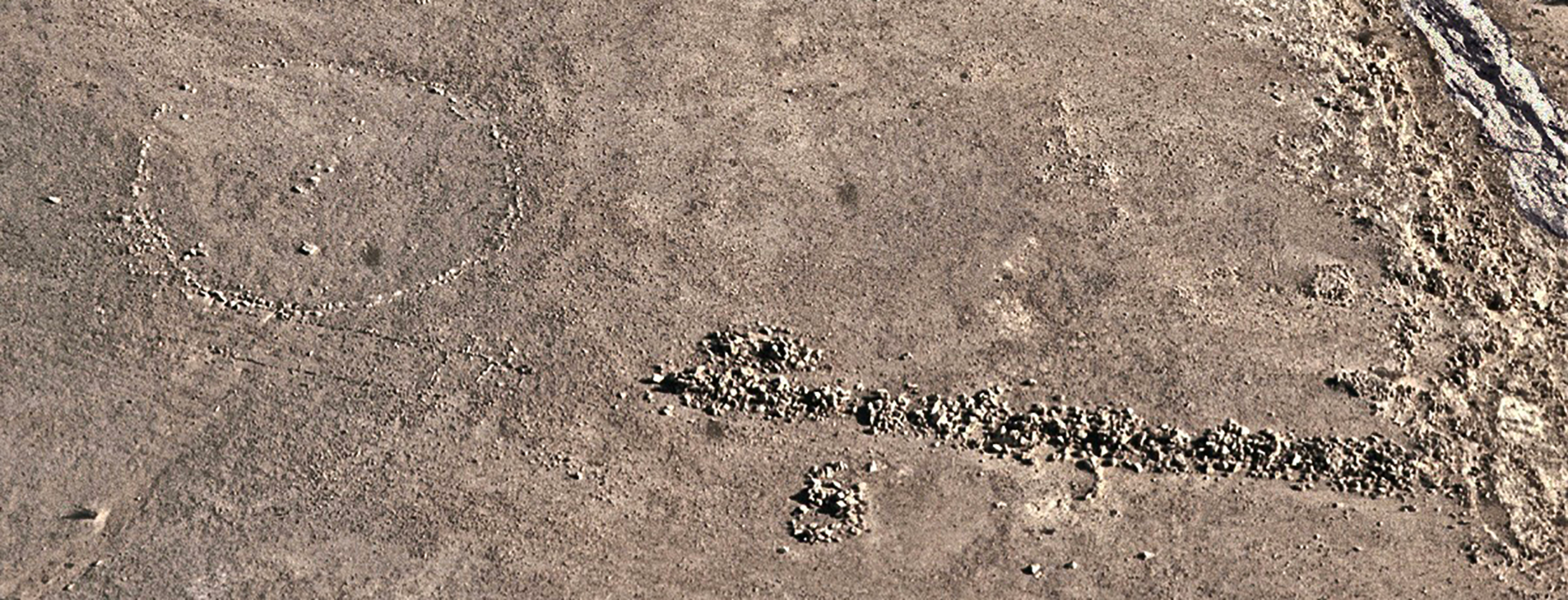
5. “Plaza” Sites
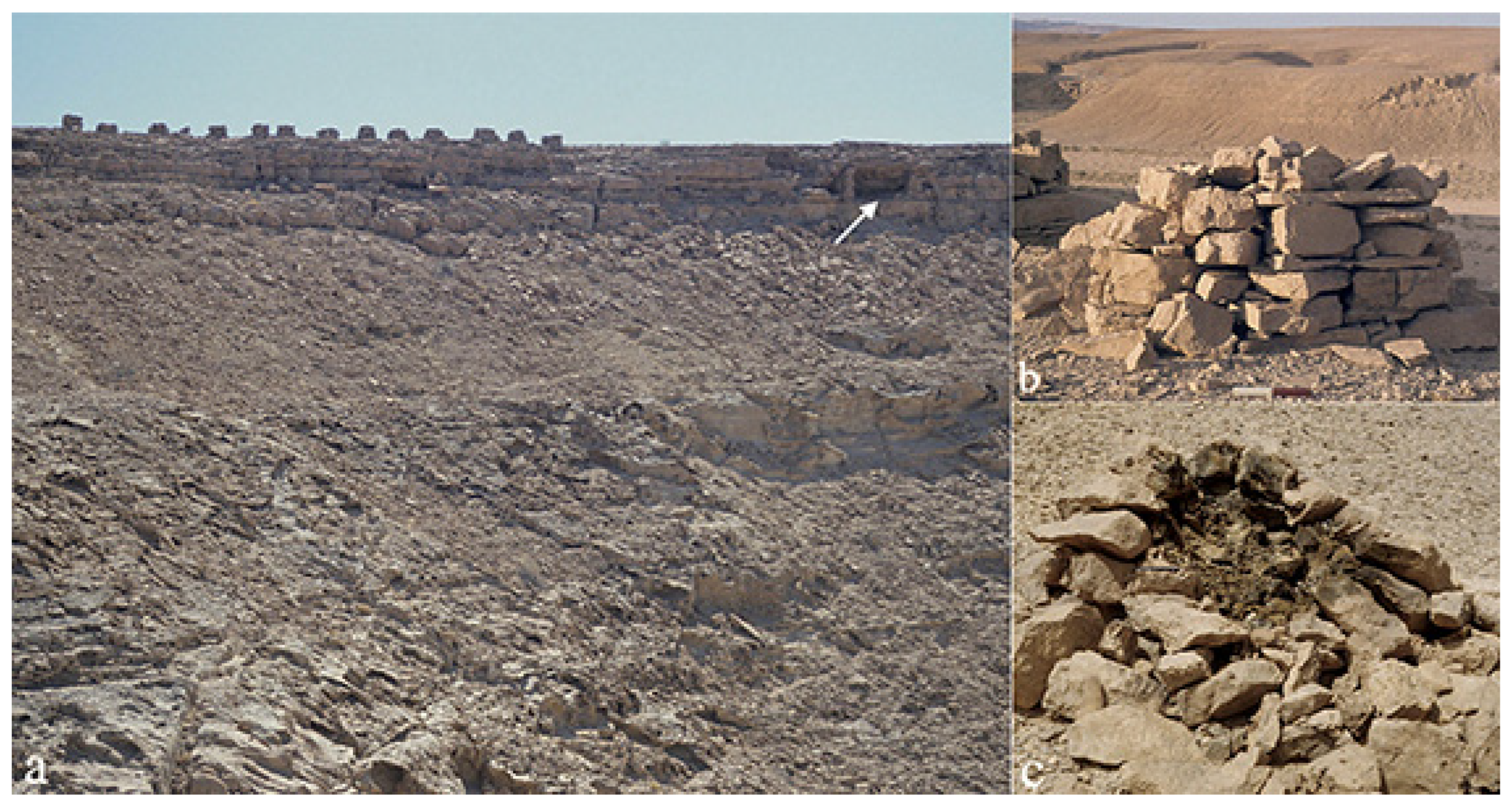
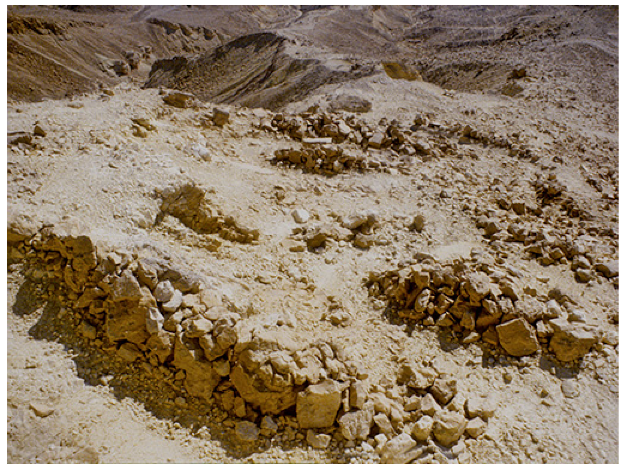
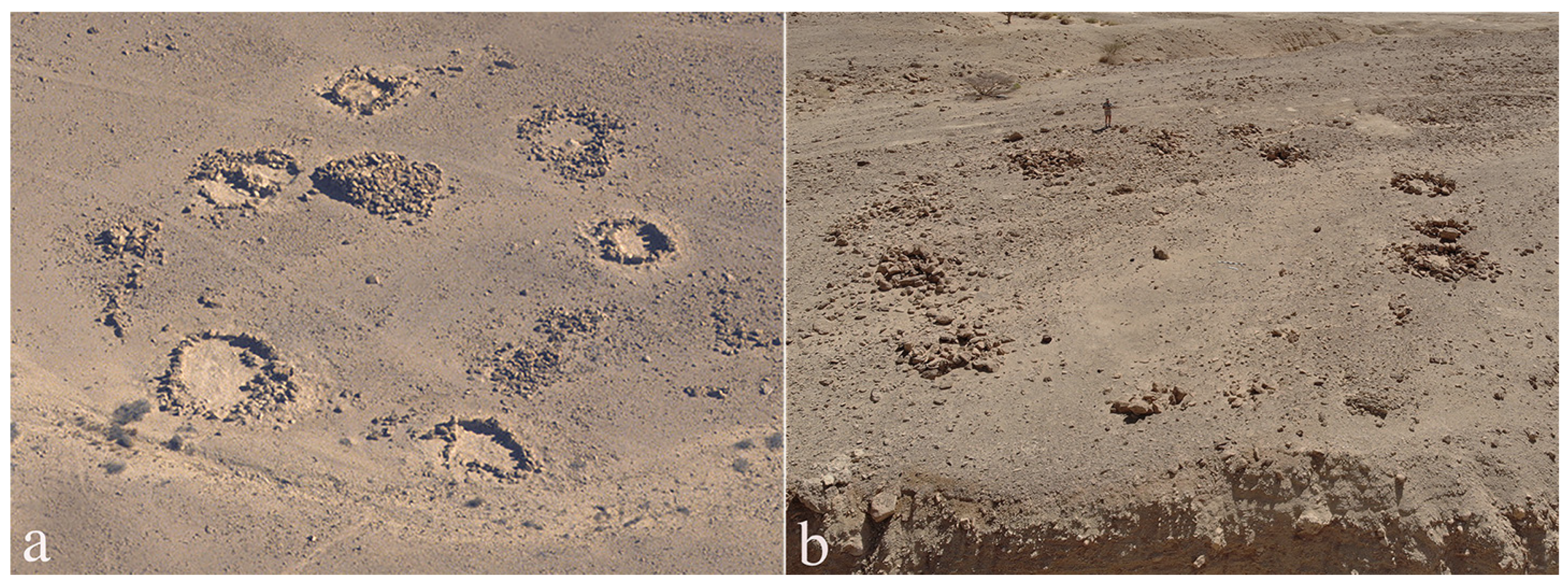
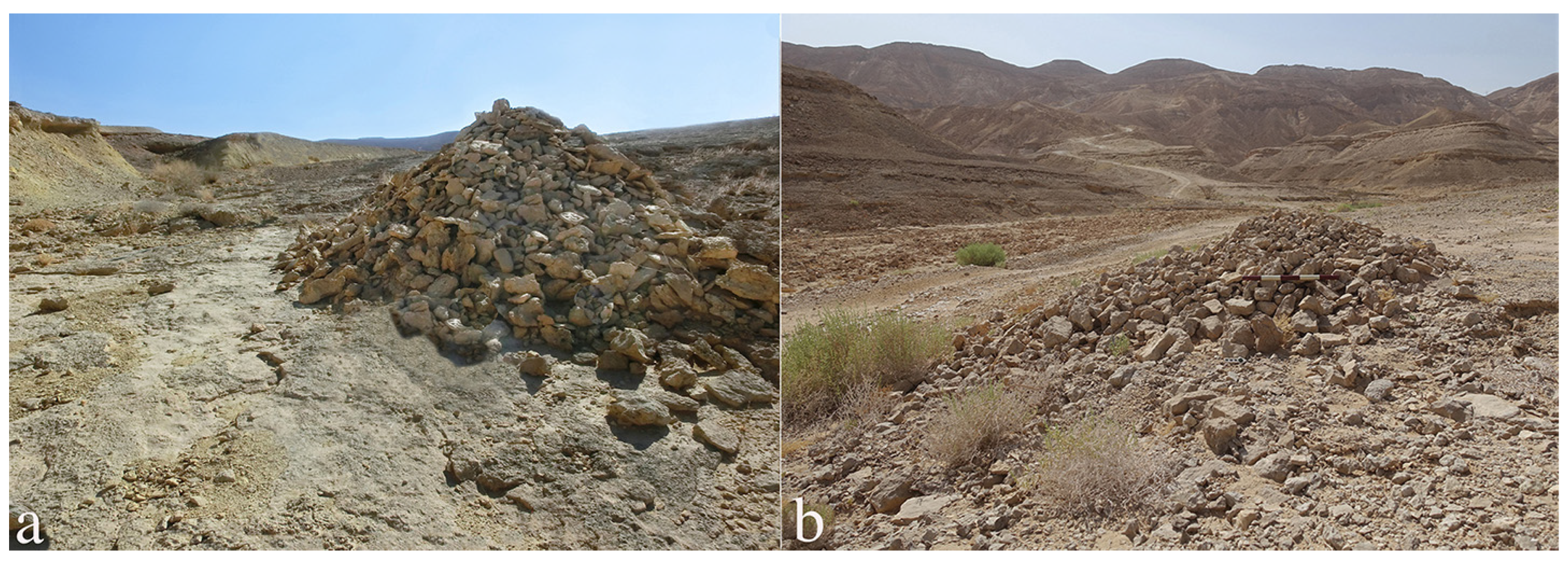
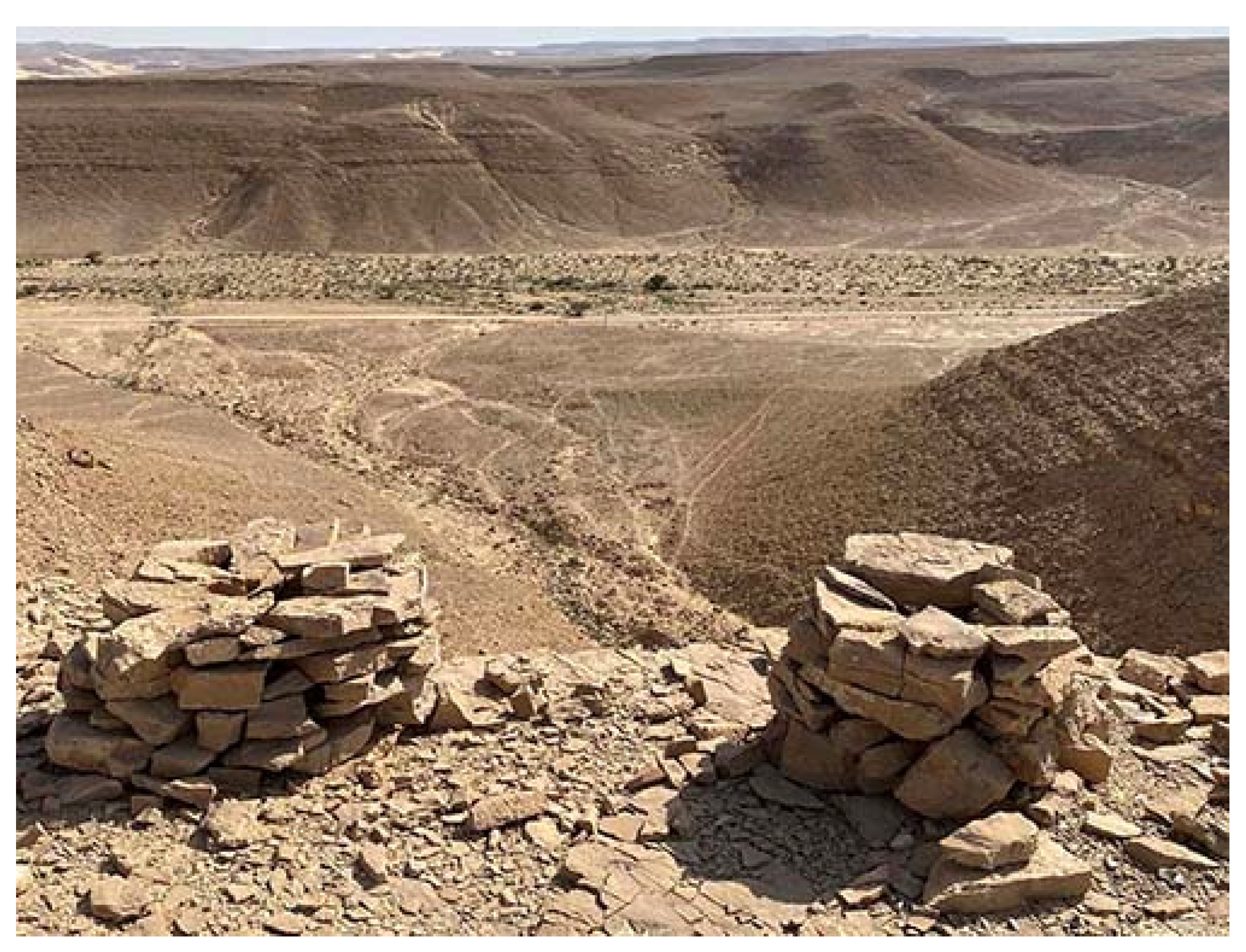
6. Stone Cairns
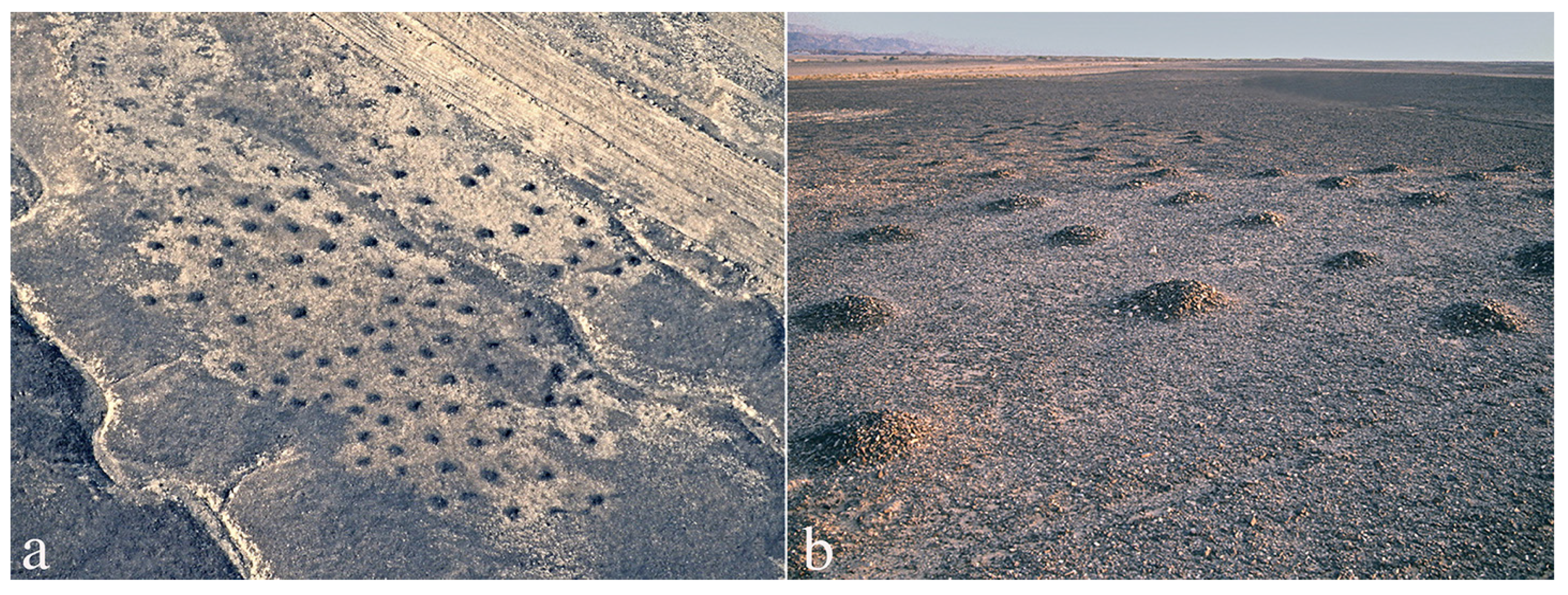
7. “Crenelations”
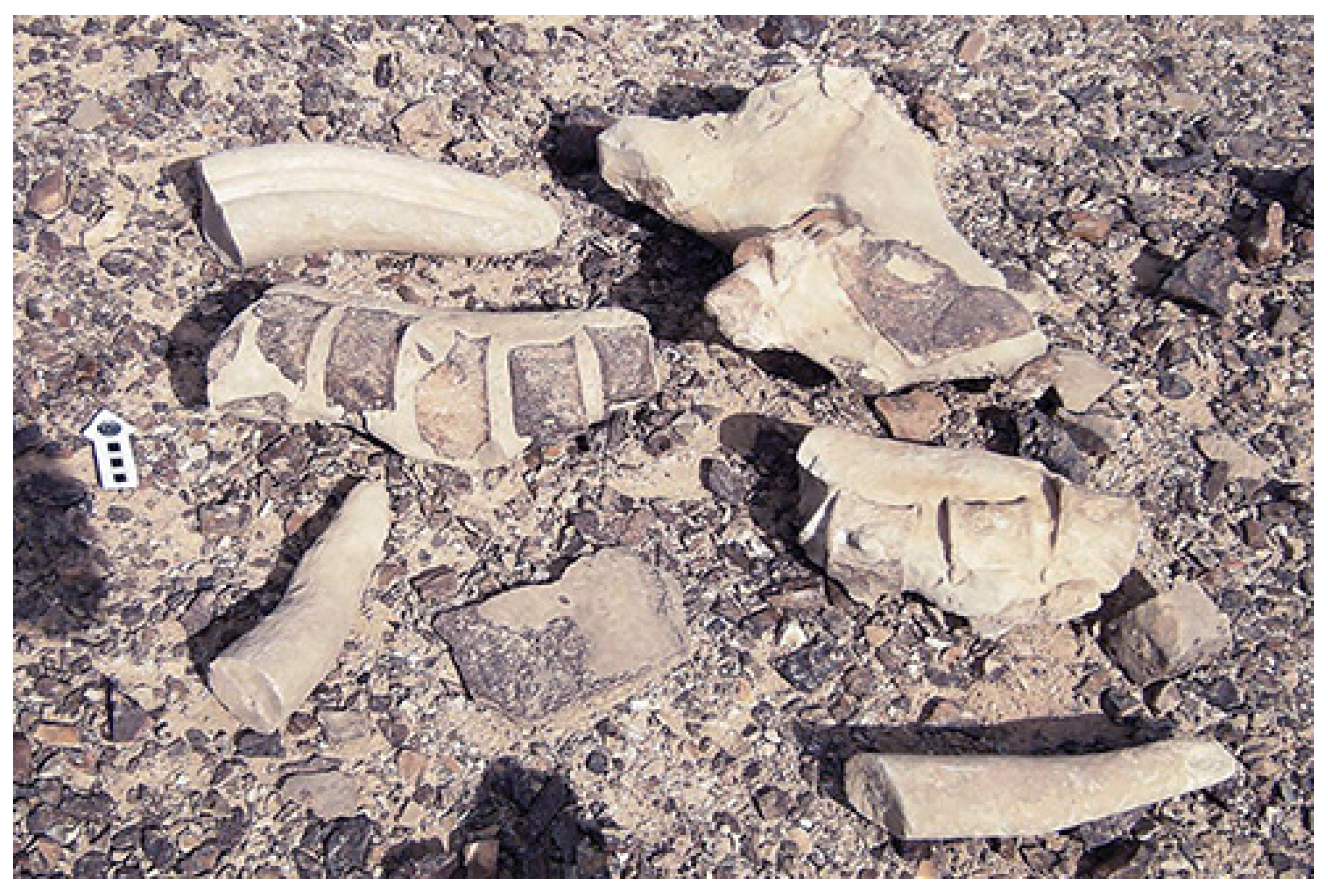
8. Vase-Shaped Installations
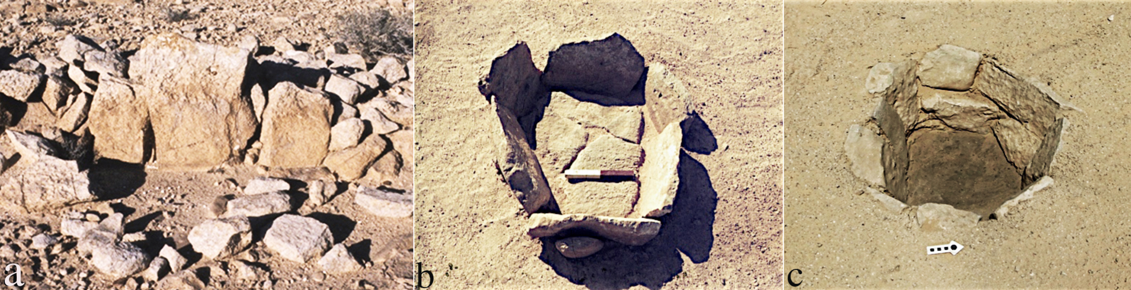
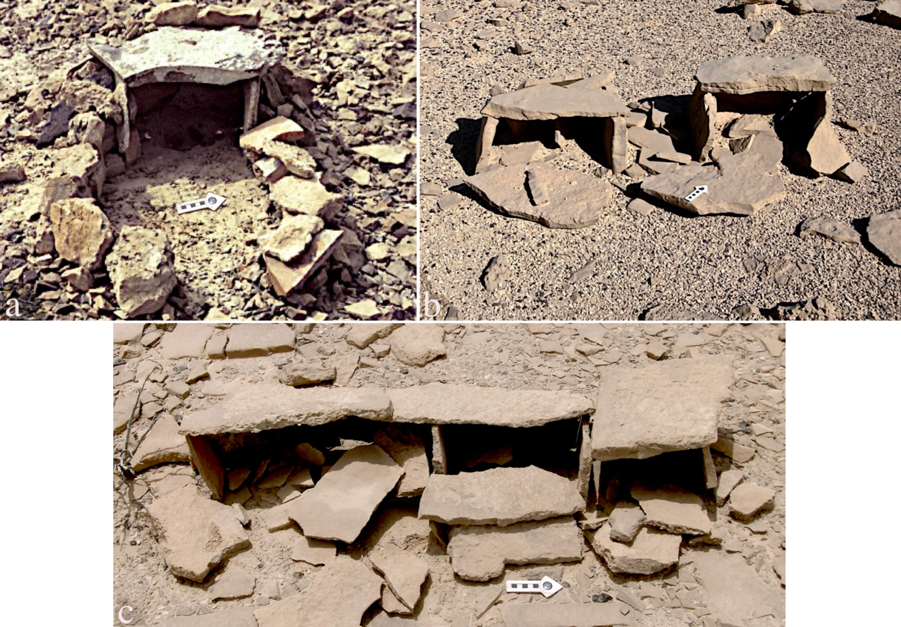
9. “Miniature Houses”
10. Summary
Funding
Institutional Review Board Statement
Informed Consent Statement
Data Availability Statement
Acknowledgments
Conflicts of Interest
| 1 | For the Neolithic mountain cult sites (termed “Rodedian”), see (Avner et al. 2019; Birkenfeld et al. 2020). |
| 2 | For a detailed description and discussions on maṣṣeboth, see (Avner 1984, pp. 115–19; 1993; 2002, chp. 4; 2018, pp. 28–34; 2021a, pp. 168–71; 2022; Avner and Horwitz 2017; Arav et al. 2016, all with references). |
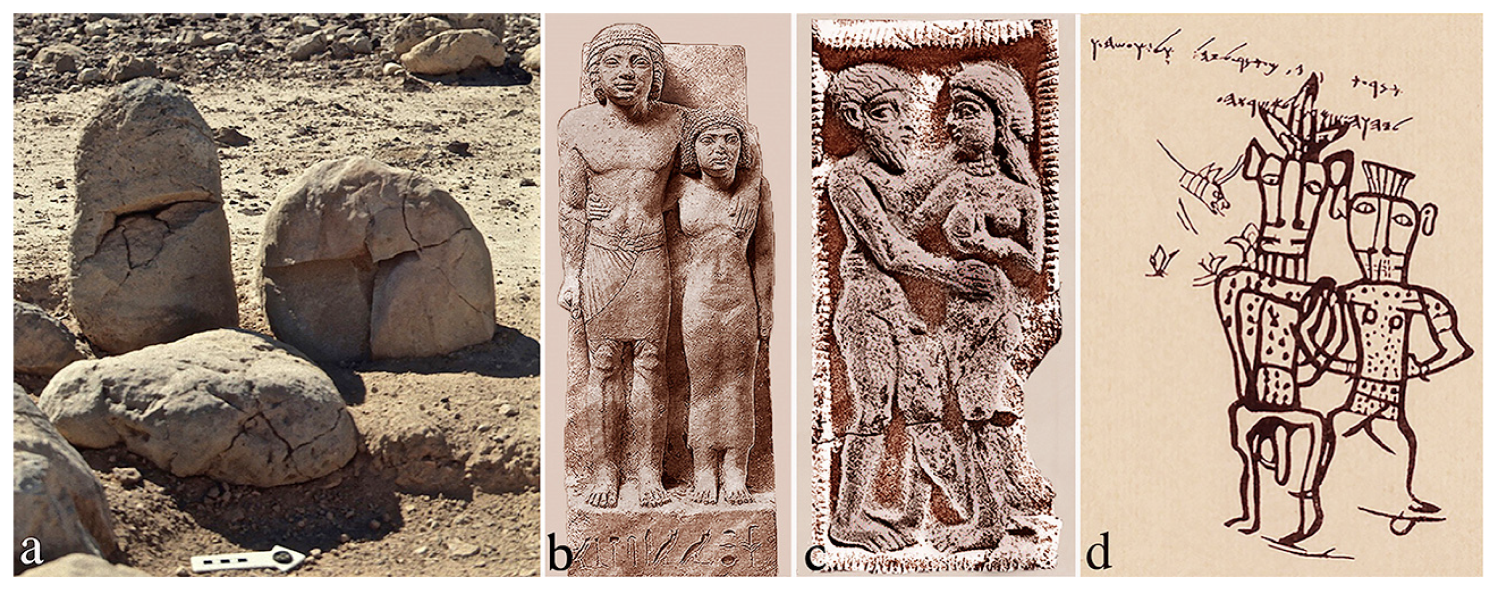
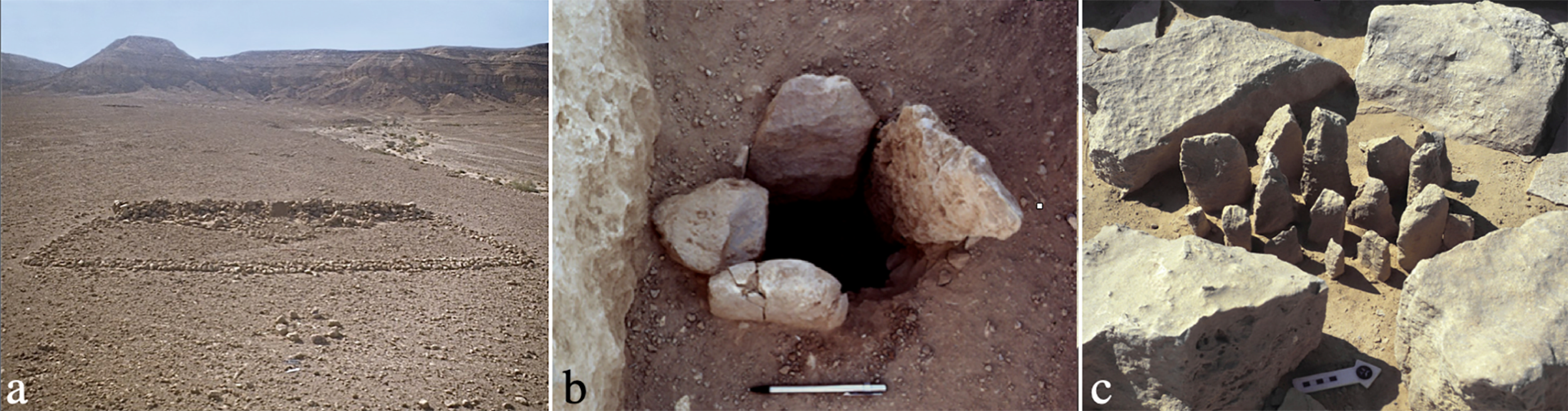
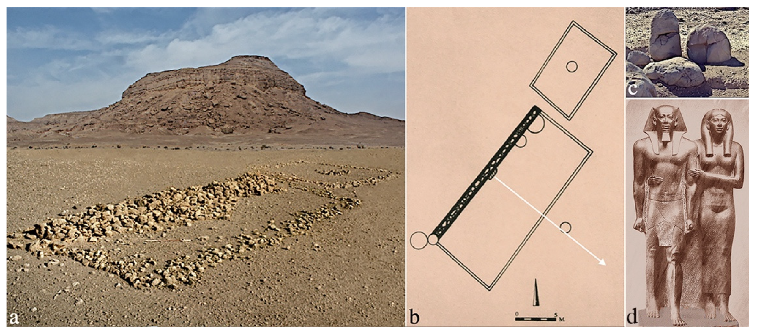
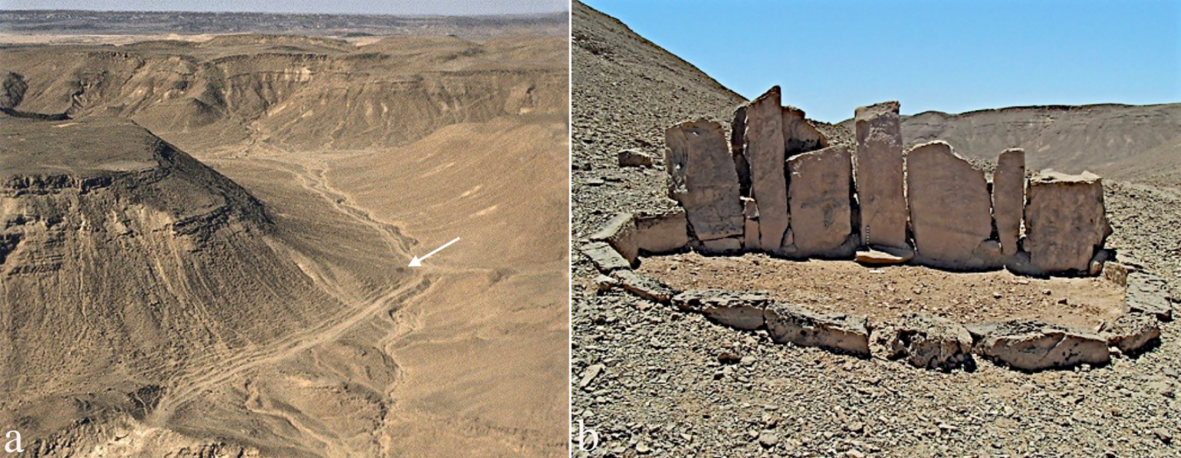
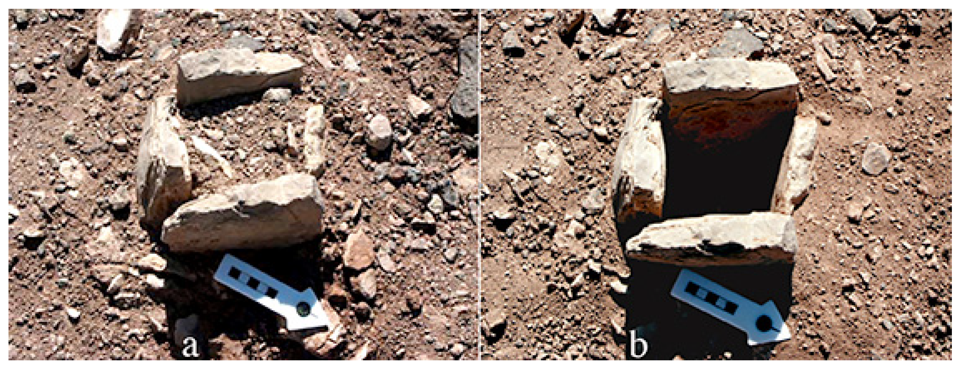
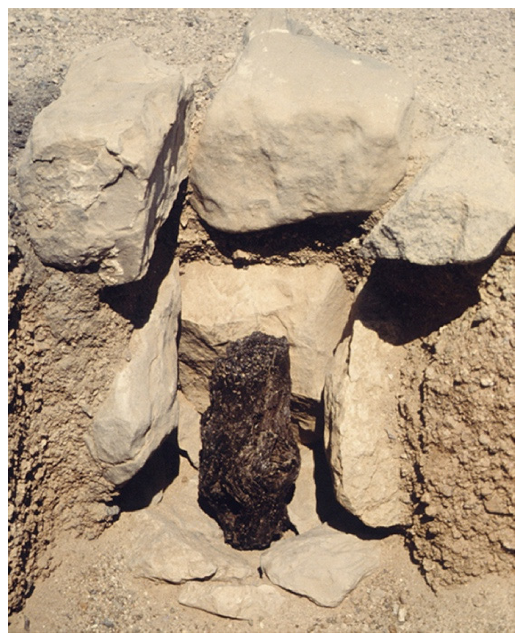
| 3 | The Natufian site of Rosh Zin was excavated by Henry (1976) and the site of Har Ḥarif (Abu Salem) by Goring-Morris (1987, 1991). The stone from Har Ḥarif (Figure 3b) was not identified by the excavator as a maṣṣebah, but see the arguments in favor of this identification in Avner (2002, p. 81). |
| 4 | An alleged site with multiple maṣṣeboth on Har Karkom, western Negev Highlands, gained international publicity as the earliest temple in the world, 40,000 years old (e.g., Anati 1993, p. 14; 2001, pp. 32–33; Anati and Mailland 2009, p. 115). Indeed, the stones have been set up by hikers, first in April 1987, then in 1992 (names are known) and finally by members of Anati’s team. In addition, the ‘site’ is located in a small wadi, where no ancient remains could have survived floods through 40 millennia. Therefore, it cannot be considered as an ancient maṣṣeboth site. |
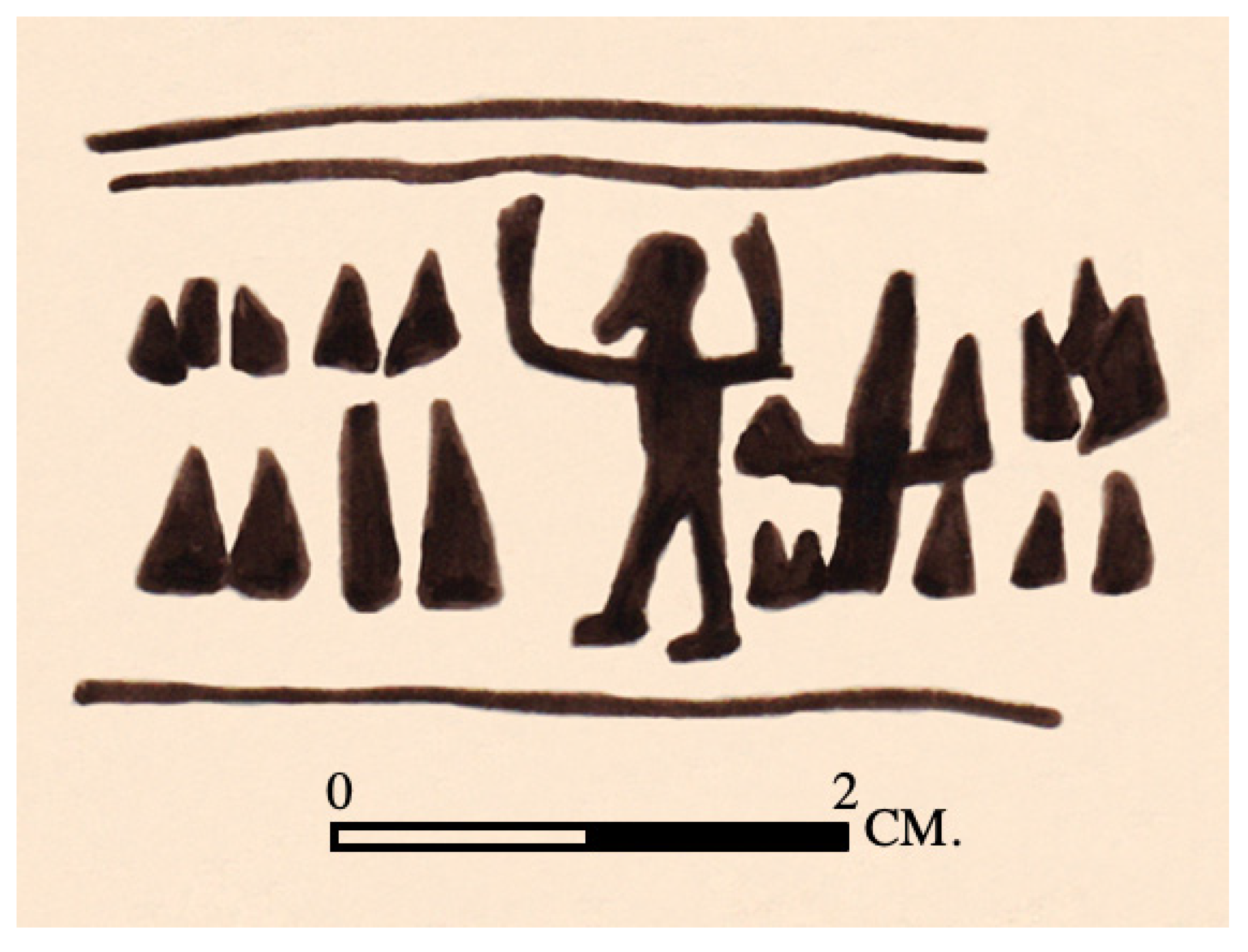
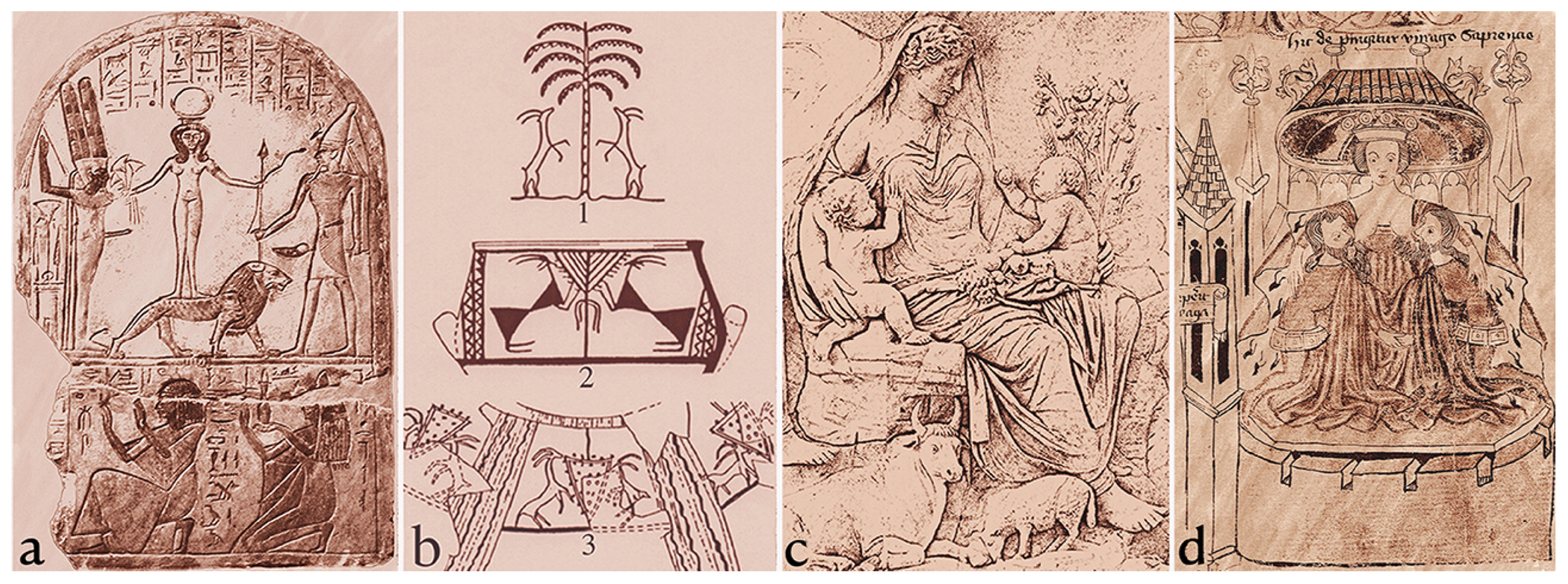
| 5 | An Egyptian seal impression from ʻEin Besor, northern Negev (Figure 13), illuminates the maṣṣeboth orientation. A bearded man stands with upraised arms in front of a group of wedge-like objects, while a hieroglyph of the East (i3bt) is behind him (Schulman 1976, p. 23, Figure 1.14). Presentations of an anthropomorph with upraised arms are very common in ancient and near-present art worldwide, including in rock art. The posture is termed orant, i.e., prayer in late Latin; however, these figures actually represented either a deity, an ancestor or a high priest (e.g., Almgren 1927, pp. 130–37; Martirossian and Israelian 1972, chp. 6; Schwarz 1983). In this seal impression, a priest is the most probable, while the wedge-like objects can be identified as a group of maṣṣeboth. The orientation, as reflected from the scene, is as follows: the priest stands in front of the maṣṣeboth with his back to the east, facing west towards the maṣṣeboth, which are facing east towards the rising sun. Schulman (ibid) identifies the hieroglyph, but did not interpret the other elements on the seal impression. Seeing the objects in front of the priest as maṣṣeboth is my suggestion (Avner 1996, p. 21). The hieroglyph is also the symbol of Sopdu, the Egyptian god of the East (B. Sass and B. Brandel, personal communication). |
| 6 | Phallic menhirs or similarly shaped smaller standing stones are known in various places in the world; see, e.g., in Ethiopia (Azaiz and Chambard 1931, I:50–76, II, Pls. 69, 75, 95, 96; Crowford 1957, 133, Pl. 39a). |
| 7 | At the site of Ramat Saharonim in the Ramon Crater, where four pairs of open sanctuaries were built in the 5th millennium BCE, Rosen suggested that the sacred orientation of the sanctuaries was towards the summer sunset, therefore, symbolizing death (Rosen and Rosen 2003; Rosen et al. 2007). In my opinion, the orientation of the open sanctuaries was vice versa, determined as perpendicular to the cult focus, i.e., the elongated cell and the incorporated maṣṣeboth, through the courtyard (Figure 31b). The cult focus faces the east–southeast and absorbs the radiation of the winter solstice sunrise (Figure 22). Members of the audience, standing in the courtyard, are facing the cult focus, while their back is turned to the sunrise. These orientations and positions are identical to those of many independent maṣṣeboth shrines; they are also well presented by the seal impression from ʻEin Besor (Figure 12), in which the priest is facing the maṣṣeboth, while his back is turned to the i3bt hieroglyph of the East. The winter solstice signifies life and fertility, since, for the desert inhabitants, it heralds the growth of the new pasture and cereals. Similarly, the winter solstice also symbolized life and fertility for European cultures (e.g., Frazer 1913, V:303, X:246–7, 331–3; Prendergast 2012, pp. 60–64; Prendergast 2017, pp. 52–65; Pesznecker 2015; Meaden 2017). In Christianity, the birth of Jesus is celebrated in the winter solstice, which is also perceived as the “birth” of the sun (Nothaft 2012). For further information on the orientation of open sanctuaries and maṣṣeboth, see Avner (2002, pp. 66, 78–79, 101–2 and Tables 11, 14). |
| 8 | Archaeological Surveys in the Negev Highlands did not record any site of the Middle Bronze Period (2000–1500 BCE). However, in the Eilat Region, remains of the period were found in a number of sites, including five copper smelting camps that yielded 15 radiocarbon dates of the period (to be published). Therefore, the Middle Bronze should not be considered “missing” in the settlement history of the Negev. |
| 9 | A random assemblage of 125 pairs from the ancient Near Eastern art showed that 89 pairs (71.2%) were presented so that the female stands on the male’s left side. In most of the opposite cases, the female was the senior and, therefore, stood on their right side (cf. Figure 16a–d). For discussion and references on left and right in ancient art and anthropology, see (Avner 1993, pp. 174–75; 2000, pp. 100–3; 2002, pp. 67, 115–19). |
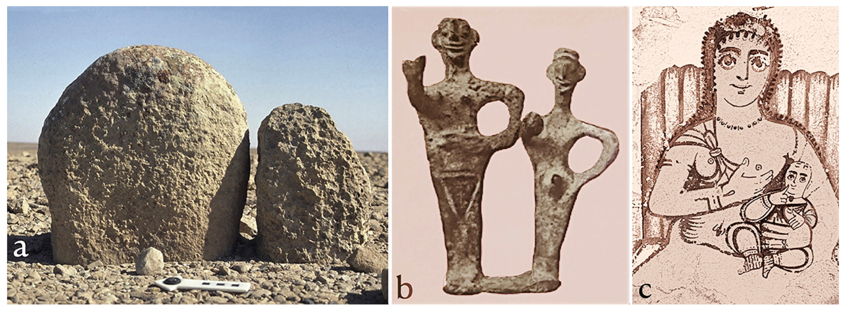
| 10 | In many publications, both figures were shown in a modern drawing with a tail or a phallus, but, in the original photos, this detail was not seen in the smaller figure. The drawn restoration led many scholars to interpret the couple as a double Bes, the Egyptian grotesque, benevolent and protective god, or as Bes and Beset (e.g., Meshel 1978, Figure 12; Beck 1982, pp. 27–31; and in Meshel 2012, pp. 165–69; Dever 1984, pp. 25–26; Hadley 1987, pp. 189–96; Keel and Uehlinger 1998, pp. 212, 220–23; Ornan 2015, pp. 58–61; 2016, p. 20). The figures do bear characteristics of Bes, but, following Gilula (1979), Margalit (1990, pp. 277, 235) and myself (Avner 1993, pp. 175, 179–78, Note 37; 2001, p. 37), the restoration of a tail/phallus on the smaller figure has been removed from the illustrations of the site’s final publications (Beck in Meshel 2012, pp. 165–67, and see Meshel’s note on P. 165). Indeed, a significant number of scholars see the couple as the representation of male and a female, and see the inscription above them added to indicate them as “Yhwh Shomron and his Asherah” (e.g., Gilula 1979; Margalit 1990; Zevit 2001, pp. 389–92; Dever 2005, pp. 166–67, 196–208; Schmidt 2013, p. 81; LeMon and Strawn 2013, pp. 112–13). My own contribution to the discussion, supporting the latter (Avner ibidem), was pointing to the ‘standard’ positioning of the female on the male’s left. The larger, male figure stands on their right side, while the smaller, with a breast and with no phallus, stands on the male’s left. Many attempts were made to avoid or deny identification of the couple with Yhwh and Asherah, despite that they are mentioned together in the inscription added above them, in three other inscriptions from the same site (Aḥituv et al. 2012, pp. 87–107) and in another inscription from Kh. al-Qom, on the Ḥebron Mountains (Zevit 2001, pp. 359–70). On the Asherah, see further below. |
| 11 | In Jordan, circular ritual enclosures reach a diameter up to 455 m! (Kennedy 2013). |
| 12 | Combinations of alignments and circles are very common in the desert, both in stone monuments and rock art. Analysis of the phenomenon leads to the suggestion that the combination represents the unity of the male and female fertility power, similarly to the yoni and lingam in the Far East religions (Zimmer 1955, pp. 22–25, 111–15; Scott 1966, pp. 159–62; Avner and Avner 1999; Aktor 2014). One manifestation of this combination is seen in the ground-plan of the pairs of rectangular sanctuaries, in which the set-back position of the smaller sanctuary aligns the circle with the elongated cell of the larger sanctuary (Figure 31b). |
| 13 | For tabular scrapers in Chalcolithic and Early Bronze cult and burial sites, see, e.g., The Peqiʻin Cave, upper Galilee (Gezov, in Shalem et al. 2013, pp. 297–98); Bab edh-Dhra, Jordan (Rast and Schaub 1980, p. 31); several hundred tabular scrapers at Mitzpeh Shalem, Judean desert (Greenhut 1989); in Nawamis tombs in Sinai (Bar-Yosef et al. 1977, p. 77; 1986, pp. 134–35); in open sanctuaries and maṣṣeboth shrines in Sinai (Avner 1984, p. 117; 2002, chp. 4, passim, Figs 4:93, 101, 103, and here Figure 24c); and in a predynastic tomb in Wadi Digla, Egypt (Rizkana and Seeher 1985, p. 249). |
| 14 | Offering objects were found by Prof. Y. Raq in a cairn line in Ethiopia. I thank him for giving me photos of the cairns and objects. |
| 15 | In the English translation (NIV), the passage is Jeremiah 31:21 (not 31:20): “Set up road signs; put up guideposts …”. |
| 16 | Nawamis (ʻArabic, literally “mosquitos”) are the names given by the Bedouins in Sinai to the beautifully built tombs, used for secondary burial and dated to the 5th–4th millennia BCE. The first nawamis tombs were excavated by Currelly (in Petrie 1906, pp. 224–44), and about 200 of them were excavated during 1971–1982, in 19 village-like clusters (Bar-Yosef et al. 1977, 1983, 1986; Goren 1998). |
| 17 | For libation and its materials, see also (Robertson Smith 1889, pp. 229–35; Haran 1968) and ample references in articles collected under “Sacrifice” in (Hastings 1920, Vol. XI, pp. 1–39). |
| 18 | On the Asherah in the Near East and in Israel, see, e.g., (Patai 1965, 1990; Dever 1984, 2005, 2014; Pettey 1990; Margalit 1990; Wiggins 1993; Hadley 2000; Hestrin 1987, 1991; Kletter 2001). |
| 19 | In short, three people per 1 sq m, on 2/3 of the sanctuaries area, in addition to many who could stand around them, multiplied by the 33 sanctuaries of Jebel Hashem al-Taref, or multiplied by 6 to 28 sanctuaries in other clusters. |
| 20 | The religious nature of Kuntilet ʻAjrud is well known, mainly based on the Hebrew inscriptions and drawings (Aḥituv et al. 2012, chp. 5, Beck, chp. 6 in Meshel 2012). However, several scholars explained the site as situated on Darb Ghaza and connected to a trade with ʻArabia through the Eilat/Ezion Geber (e.g., Hadley 1993, 2000; Lipinski 2006, p. 373; Finkelstein 2013, 2014; Na’aman 2013; Niehr 2013), and see more references in (Strawn and LeMon 2018, Note 11). Indeed, however, the site is situated on another road, 15 km west of Darb Ghaza, that leads to southern Sinai (Avner 2021b, §§ 51–53). |
| 21 | While writing this paper, I had the opportunity for a four-day walk on ancient roads in the Negev Highlands (March 2023), with the discovery of more prehistoric and later cult sites. I also walked on two of the ancient ascents connecting the Yotvata Oasis in the southern ʻAraba, up to ʻUvda Valley and further west (July 2023). |
References
- Aḥituv, Shmuel, E. Eshel, and Zeev Meshel. 2012. The Inscriptions. In Kuntilat ʻAjrud (Ḥorvat Teman): An Iron Age II Religious Site on the Judah-Sinai Border. Edited by Zeev Meshel. Jerusalem: Israel Exploration Society, pp. 73–142. [Google Scholar]
- Akkermans, Peter M. M. G., and Merel L. Brüning. 2020. East of Azraq: Settlement, burial and chronology from the Chalcolithic to the Bronze Age and Iron Age in the Jebel Qurma region, Black Desert, north-east Jordan. In Landscape of Survival: The Archaeology and Epigraphy of Jordan’s North-Eastern Desert and Beyond. Edited by Peter M. M. G. Akkermans. Leiden: Sidestone Press, pp. 185–316. [Google Scholar]
- Aktor, Mikael. 2014. The śivaliṅga between artifact and nature: The Ghṛṣṇeśvaraliṅga in Varanasi and the bāṇaliṅgas from the Narmada River. In Objects of Worship in South Asian Religions. Edited by Knut A. Jacobsen, Mikael Aktor and Kristina Myrvold. London: Routledge, pp. 14–32. [Google Scholar]
- Albright, William Foxwell. 1957. The High Place in Ancient Palestine. Vetus Testamentum Supplement 4: 242–58. [Google Scholar]
- Almgren, Oscar. 1927. Hällristningar och kultbruk. Bidrag till belysning av de nordiska bronsåldersristningarnas innebörd. Stockholm: Bröderna Lagerström. [Google Scholar]
- Anati, Emmanuel. 1987. I Siti A Plaza Di Har Karkom. Capo di Ponte: Edizioni del Centro. [Google Scholar]
- Anati, Emmanuel. 1993. Har Karkom, in the Light of New Discoveries. Capo di Ponte: Edizioni del Centro. [Google Scholar]
- Anati, Emmanuel. 2001. The Riddle of Mount Sinai. Capo di Ponte: Edizioni del Centro. [Google Scholar]
- Anati, Emmanuel, and Federico Mailland. 2009. Archaeological Survey of Israel: Map of Har Karkom (229). Capo di Ponte: Edizioni del Centro. [Google Scholar]
- Arav, Reuma, Sagi Filin, Uzi Avner, and Dani Nadel. 2016. Three-dimensional documentation of Maṣṣeboth sites in the ʻUvda Valley Area, Southern Negev, Israel. Digital Applications in Archaeology and Cultural Heritage 3: 9–21. [Google Scholar] [CrossRef]
- Arnold, Dieter. 1999. Meisterwerke des Alten Reiches. Antike Welt 30: 499–502. [Google Scholar]
- Avner, Uzi. 2016. Ancient Roads in the ʻArabah. Dead Sea and Arava Studies 8: 25–44. [Google Scholar]
- Avner, Uzi. 1984. Ancient Cult Sites in the Negev and Sinai Deserts. Tel Aviv 11: 115–31. [Google Scholar] [CrossRef]
- Avner, Uzi. 1993. Maṣṣeboth Sites in the Negev and Sinai and Their Significance. In Second International Congress on Biblical Archaeology in Jerusalem 1990. Edited by Joseph Aviram. Jerusalem: Israel Exploration Society, pp. 166–81. [Google Scholar]
- Avner, Uzi. 1996. Maṣṣeboth in the Negev and Sinai and Their Interpretation. Master’s thesis, Hebrew University, Jerusalem, Israel. (In Hebrew, unpublished). [Google Scholar]
- Avner, Uzi. 1997. Naḥal Paran Survey. Excavations and Surveys in Israel 16: 132–33. [Google Scholar]
- Avner, Uzi. 2000. Nabataean Standing Stones and Their Interpretation. Aram 11–12: 95–120. [Google Scholar] [CrossRef]
- Avner, Uzi. 2001. Sacred Stones in the Desert. Biblical Archaeology Review 27: 30–41. [Google Scholar]
- Avner, Uzi. 2002. Studies in the Material and Spiritual Culture of the Negev and Sinai Population, During the 6th–3rd Millennia BC. Ph.D. dissertation, The Hebrew University, Jerusalem, Israel. Available online: https://www.adssc.org/wp-content/uploads/2019/04/PhD-Uzi-RS.pdf (accessed on 18 September 2023).
- Avner, Uzi. 2018. Protohistoric Developments of Religion and Cult in the Negev Desert. Tel Aviv 45: 23–62. [Google Scholar] [CrossRef]
- Avner, Uzi. 2020. Burial in the desert and the Perception of Life and Death. Qadmoniot 160: 88–95. (In Hebrew). [Google Scholar]
- Avner, Uzi. 2021a. Prehistoric Cult Sites Along the Ancient Desert Roads. In The Incense Roads 2020. Edited by Haim Ben-David and Dan Perry. Jerusalem: Magness, pp. 165–88. (In Hebrew) [Google Scholar]
- Avner, Uzi. 2021b. The Desert’s Role in the Formation of Early Israel and the Origin of Yhwh. Entangled Religions 12: 1–58. [Google Scholar] [CrossRef]
- Avner, Uzi. 2022. Yotvata, a Fortress on a Road Junction. In Yotvata, The Zeev Meshel Excavations (1974–1980): The Iron I “Fortress” and the Early Islamic Settlement. Section I: Yotvata Hill- The Iron I “fortress” and Other Remains. Edited by Lily Singer-Avitz and Etan Ayalon. Tel Aviv: Institute of Archaeology, Tel Aviv University, pp. 11–19. [Google Scholar]
- Avner, Uzi. 2023. Open-Air sanctuaries in the Desert and their Relations to the Chalcolithic-Early Bronze Built Temples. Eretz Israel 35: 192–202. (In Hebrew). [Google Scholar]
- Avner, Uzi, and Liora Kolska Horwitz. 2017. Animal Sacrifice and Offering from Cult and Mortuary Sites of the Negev and Sinai, 6th–3rd Millennia BC. Aram 29: 35–70. [Google Scholar]
- Avner, Uzi, and R. Avner. 1999. Circles, Triangles and Lines in Desert Archaeological Remains and Rock Engravings, and Their Interpretations. In Rock Art Studies: NWES of the World 1. Proceeding of the International Rock Art Congress, Turin 1995. Edited by Paul G. Bahn and Angelo Fossati. Pinerolo: Centro Study Museod’Arte Preistorica (CD). [Google Scholar]
- Avner, Uzi, Moti Shem-Tov, Lior Enmar, Gideon Ragolski, Rachamim Shem-Tov, and Omry Barzilai. 2019. Neolithic Cult sites in the Eilat Mountains, Israel. In Isaac Went out…to the Field” (Genesis 24: 63): Studies in Archaeology and Ancient Cultures in Honor of Isaac Gilead. Edited by Haim Goldfus, Mayer I. Gruber, Shamir Yona and Peter Fabian. Oxford: Archaeopress, pp. 14–35. [Google Scholar]
- Avni, Gideon. 2007. From Standing Stones to Mosques in the Negev desert: The Archaeology of Religious Transformation on the Fringes. Near Eastern Archaeology 70: 124–38. [Google Scholar] [CrossRef]
- Azaiz, Révérend-père, and Roger Chambard. 1931. Cinq Années Recherches Archéologiques en Éthiopie. Paris: Librairie Orientaliste Paul Geuthner, vols. I, II. [Google Scholar]
- Bar-Yosef, Ofer, Anna Belfer, Avner Goren, and Patricia Smith. 1977. The Nawamis near ʻEin Huderah. Israel Exploration Journal 27: 65–88. [Google Scholar]
- Bar-Yosef, Ofer, Anna Belfer-Cohen, Avner Goren, Israel Hershkovitz, Ornit Ilan, H. K. Mienis, and B. Sass. 1986. Nawamis and Habitation Sites Near Gebel Gunna, Southern Sinai. Israel Exploration Journal 36: 121–67. [Google Scholar]
- Bar-Yosef, Ofer, and E. Ayalon. 2001. Chalcolithic Ossuaries-What do they imitate and why? Qadmoniot 34: 34–43. (In Hebrew). [Google Scholar]
- Bar-Yosef, Ofer, Israel Hershkovitz, Gideon Arbel, and Avner Goren. 1983. The Orientation of Nawamis Entrances in Southern Sinai: Expressions of Religious Belief and Seasonality? Tel Aviv 10: 52–60. [Google Scholar] [CrossRef]
- Beck, Pirhiya. 1982. The Drawings from Ḥorvat teman (Kuntilat ʻAjrud). Tel Aviv 9: 3–68. [Google Scholar] [CrossRef]
- Biçakçi, Erhan. 1995. Çayönü House Models and a Reconstruction Attempt for the Cell-Plan Buildings. In Reading in Prehistory: Studies Presented to Halet Çambel. Istanbul: Graphis, pp. 101–27. [Google Scholar]
- Birkenfeld, Michal, Uzi Avner, Daniella E. Bar-Yosef Mayer, Linda Scott Cummings, Filipe Natalio, Frank H. Neumann, Naomi Porat, Louis Scott, Tal Simmons, Michael B. Toffolo, and et al. 2020. Hunting in the Skys: Dating, Paleoenvironment and Archaeology at the Late Pre-Pottery Neolithic B Site of Naḥal Roded 110, Eilat Mountains, Israel. Paléorient 46: 43–68. [Google Scholar] [CrossRef]
- Burrows, M. 1934. From Pillar to Post. Journal of the Palestine Oriental Society 14: 42–51. [Google Scholar]
- Callaway, Joseph A. 1963. Burial in Ancient Palestine from the Stone Age to Abraham. Biblical Archaeology 26: 74–91. [Google Scholar] [CrossRef]
- Caner, Daniel F. 2010. History and Hagiography from the Late Antique Sinai. Liverpool: Liverpool University Press. [Google Scholar]
- Conder, Claude Reignier. 1885. Heth and Moab: Exploration in Syria in 1881 and 1882. London: Bentley. [Google Scholar]
- Crowford, Osbert Guy Stanhope. 1957. The Eye Goddess. New York: Macmillan. [Google Scholar]
- Dever, William G. 1984. Asherah, Consort of Yahweh? New Evidence from Kuntillet ʻAjrud. Bulletin of the American School of Oriental Research 255: 21–27. [Google Scholar] [CrossRef]
- Dever, William G. 2005. Did God Have a Wife? Grand Rapid and Cambridge: Eerdmans. [Google Scholar]
- Dever, William G. 2014. The Judaean “Pillar-Base Figurines”, Mother or “Mother Goddess”? In Family and Household Religion: Toward a Synthesis of Old Testament Studies, Archaeology, Epigraphy and Cultural Studies. Edited by Rainer Albertz, Beth Alpert Nakhai, Saul M. Olyan and Rüdiger Schmitt. Winona Lake: Eisenbrauns, pp. 129–41. [Google Scholar]
- Doe, Brian. 1971. Southern Arabia. London: Thames and Hudson. [Google Scholar]
- Eddy, Frank W., and Fred Wendorf. 1999. An Archaeological Investigation of the Central Sinai, Egypt. Boulder: University Press of Colorado. [Google Scholar]
- Eisenberg, E. 1980. Excavation of Site 12 in ʻUvda Valley. Hadashot Arkheologiot 42: 74–75. (In Hebrew). [Google Scholar]
- Eliade, Mircea. 1978. A History of Religious Ideas, Vol. I. From the Stone Age to the Eleusinian Mysteries. Chicago: Chicago University Press. [Google Scholar]
- Evans, John Davies. 1959. Malta: Ancient People and Places. London: Themes & Hadson. [Google Scholar]
- Evans, John Davies. 1971. The Prehistoric Antiquities of the Maltese Islands: A Survey. London: University of London. [Google Scholar]
- Evenari, Michael, Leslie Shanan, and Naphtali Tadmor. 1971. The Negev: The Challenge of the Desert. Cambridge: Harvard University Press. [Google Scholar]
- Fahd, Toufic. 1968. Le pantheon de lʼArabie central à la veille de lʼHégire. Paris: Paul Geuthner. [Google Scholar]
- Fergusson, James. 1872. Rude Stone Monuments. London: John Murray. [Google Scholar]
- Finkelstein, Israel. 2013. Notes on the Historical Setting of Kuntilat ʻAjrud. Maarav 20: 13–23. [Google Scholar] [CrossRef]
- Finkelstein, Israel. 2014. The Southern Steppe of the Levant ca. 1050–750 BCE: A Framework for a Territorial History. Palestine Exploration Quarterly 146: 89–104. [Google Scholar] [CrossRef]
- Frazer, James George. 1913. The Belief in Immortality and the Worship of the Dead. Londo: Macmillan. [Google Scholar]
- Fujii, Sumio. 2014. Slab-Lined Feline Representations: New Finding at ʻAwja 1, A Late Neolithic Open Air Sanctuaries in Southernmost Jordan. In Proceeding of the 9th International Congress on the Archaeology of the Ancient Near East, Basel, Switzerland, June 9–13. Edited by R. A. Stucky, O. Kaelin and H. P. Mathys. Basel: Institute francais du Proche-Orient, vol. 3, pp. 249–59. [Google Scholar]
- Fujii, Sumio, Takuro Adachi, Hitoshi Endo, and Masatoshi Yamafuji. 2013. ʻAuja Sites: Supplementary investigation of Neolithic Open Sanctuaries in Southernmost Jordan. Annual of the Department of Antiquities of Jordan 57: 337–57. [Google Scholar]
- Galinsky, Karl. 1992. Venus, Polysemy and the Ara Pacis Augustae. American Journal of Archaeology 96: 457–75. [Google Scholar] [CrossRef]
- Garstang, John, and J. B. E. Garstang. 1948. The Story of Jericho, revised ed. London and Edinburgh: Marshall, Morgan & Scott. [Google Scholar]
- Gilmore, Michael, Mohammed Al-Ibrahim, and Abduljawwad S. Murad. 1982. Preliminary Report on the Northwestern and Northern Region Survey 1981 (1401). Atlal 6: 9–23. [Google Scholar]
- Gilula, Mordechai. 1979. To Yahweh Shomron and his Asherah. Shnaton, an Annual for Biblical and Ancient Near Eastern Studies 3: 129–37. [Google Scholar]
- Goren, Avner. 1998. The Nawamis in Southern Sinai. In Studies in Archaeology of Nomads. Edited by Shmuel Aḥituv. Be’er Sheva: Ben-Gurion University Press, pp. 59–86. (In Hebrew) [Google Scholar]
- Goring-Morris, Adrian Nigel. 1987. At the Edge, Terminal Pleistocene Hunter-Gatherers in the Negev and Sinai. Oxford: BAR-International Series 361. [Google Scholar]
- Goring-Morris, Adrian Nigel. 1991. The Harifian of the Southern Levant. In The Natufian Culture in the Levant. Edited by Ofer Bar-Yosef and François R. Valla. Ann Arbor: Université de Lyon, CNRS & ENS de Lyon, pp. 173–216. [Google Scholar]
- Grabar, André. 1966. Byzantium, from the Death of Theodosius to the Rise of Islam. London: Thames & Hudson. [Google Scholar]
- Greenhut, Zvi. 1989. Mispeh Shalem-Flint Tools. In Excavations in the Judean Desert. Edited by Pesach Bar-Adon and Zvi Greenhut. Jerusalem: Israel Antiquities Authority, pp. 60–77, (In Hebrew with English summary). [Google Scholar]
- Hadley, Judith M. 1987. Some Drawings and Inscriptions on Two Pithoi from Kuntillet ʻAjrud. Vetus Testamentum 37: 189–96. [Google Scholar] [CrossRef]
- Hadley, Judith M. 1993. Kuntilet ʻAjrud: Religious Center or Desert Way Station? Palestine Exploration Quarterly 125: 115–24. [Google Scholar] [CrossRef]
- Hadley, Judith M. 2000. The Cult of Asherah in Ancient Israel and Judah. Cambridge: Cambridge University Press. [Google Scholar]
- Hadzisteliou-Price, Theodora. 1971. Double and Triple Representations in Greek Art and Religious Thought. Journal of Hellenistic Studies 91: 48–69. [Google Scholar] [CrossRef]
- Haran, M. 1968. Libations. Encyclopedia Biblica V: 883–86. (In Hebrew). [Google Scholar]
- Hastings, James, ed. 1920. Encyclopedia of Religion and Ethics. Edinburgh: Clark, Vol. XI, pp. 1–39. [Google Scholar]
- Hendel, Ronald S. 1997. Aniconism and Anthropomorphism in ancient Israel. In The Image and the Book: Iconic Cult, Aniconism and Rise of Book Religion in Israel and the Ancient Near East. Leuven: Peters, pp. 205–228. [Google Scholar]
- Henry, Donald O. 1976. Rosh Zin: A Natufian Settlement Near Ein ʻAvdat. In Prehistory and Paleoenvironment in the Central Negev, Israel. Edited by Anthony Marks. Dallas: Society for American Archaeology, pp. 317–47. [Google Scholar]
- Hestrin, Ruth. 1987. The Lachish Ewer and the Asherah. Israel Exploration Journal 37: 212–23. [Google Scholar]
- Hestrin, Ruth. 1991. Understanding the Asherah: Exploring Semitic Iconography. Biblical Archaeology Review 17: 50–59. [Google Scholar]
- Ibn al-Kalbi, Hisham. 1952. The Book of Idols (Kitab al-Asnam). Translated from ʻArabic by Nabih Amin Faris. Princeton: Princeton University. [Google Scholar]
- Israeli, Y., and D. Naḥlieli. 2000. Remains of campsites, faith and worship along the desert roads. In The Incense Roads. Edited by Ezra Orion and Avner Goren. Sde Boqer: Midreshet Sde Boqer, pp. 114–22. (In Hebrew) [Google Scholar]
- Kaplony, P. 1980. Ka House. In Lexikon der Ägyptologie III. Edited by Wolfgang Helck and Eberhard Otto. Wiesbaden: Harrassowitz, pp. 284–87. [Google Scholar]
- Keel, Othmar, and Christoph Uehlinger. 1998. Gods, Goddesses, and Images of Gods in Ancient Israel. Minneapolis: Fortress Press. [Google Scholar]
- Kennedy, David L. 2011. The “Work of Old Man” in Arabia: Remote Sensing in Interior Arabia. Journal of Archaeological Science 38: 3185–203. [Google Scholar] [CrossRef]
- Kennedy, David L. 2012. The Cairn of Hani: Significance, Present Condition and Context. Annual of the Department of Antiquities of Jordan 56: 483–505. [Google Scholar]
- Kennedy, David L. 2013. Remote Sensing and ‘Big Circles’, a New Type of Prehistoric Sites in Jordan and Syria. Zeitschrift für Orient-Archäologie 6: 44–63. [Google Scholar]
- Kennedy, David L. 2015. Kites in Saudi Arabia. Arabian Archaeology and Epigraphy 26: 177–95. [Google Scholar] [CrossRef]
- Kletter, Raz. 2001. Between Archaeology and Theology: The Pillar Figurines from Judah and the Asherah. In Studies in the Archaeology of the Iron Age in Israel and Jordan. Edited by Amihai Mazar. Sheffield: Sheffield Academic Press, pp. 179–216. [Google Scholar]
- LeMon, Joel M., and Brent A. Strawn. 2013. Once More, YHWH and Company at Kuntilat ʻAjrud. Maarav 20: 83–120. [Google Scholar] [CrossRef]
- Levi, S. 1980. Faith and Cult of the Bedouins in Southern Sinai. Tel Aviv: The Society for Protection of Nature. (In Hebrew) [Google Scholar]
- Levi, S. 1987. The Bedouins in the Sinai Desert, a Pattern of Desert Society. Tel Aviv: Schocken. (In Hebrew) [Google Scholar]
- Lipinski, Edward. 2006. On the Skirt of Canaan in the Iron Age: Historical and Topographical Researches. Leuven: Peeters. [Google Scholar]
- Margalit, Baruch. 1990. The Meaning and Significance of Asherah. Vetus Testamentum 40: 264–97. [Google Scholar] [CrossRef]
- Martirossian, H. A., and H. R. Israelian. 1972. The Rock Carvings of the Ghegham Mountain Range. Translated from Armenian by K. Hofman. Yerevan. Available online: http://www.iatp.am/resource/artcult/rockart/geghama/book-e.htm (accessed on 18 September 2023).
- May, Herbert Gordon. 1935. Material Remains of the Megiddo Cult. Chicago: Chicago University Press. [Google Scholar]
- Meaden, G. Terence. 2017. Drombeg Stone Circle, Ireland, analyzed with Respect to Sunrises and Lithic Shadow-Casting for the Eight Traditional Agricultural Festival Dates and Further Validated by Photography. Journal of Lithic Studies 4: 5–37. [Google Scholar] [CrossRef]
- Meshel, Zeev. 1978. Kuntillet ʻAjrud: A Religious Centre from the Judaean Monarchy on the Border of Sinai. Israel Museum Catalogue No. 75. Jerusalem: Israel Museum. [Google Scholar]
- Meshel, Zeev, ed. 2012. Kuntilat ʻAjrud (Ḥorvat Teman): An Iron Age II Religious Site on the Judah-Sinai Border. Jerusalem: Israel Exploration Society, pp. 73–142. [Google Scholar]
- Mettinger, Tryggve. 1995. No Graven Image? Israelite Aniconism in the Near Eastern Context. Stockholm: Almquist & Wiksell International. [Google Scholar]
- Milburn, Mark. 1977. AÏr occidental: Essai de chronologie relative de quelques monument lithiques. Almogaren 7: 147–54. [Google Scholar]
- Milburn, Mark. 1983. Complex Stone Structures as Expressions of Religious Belief. In Valcamonica Symposium III 1979: Proceedings, The Intellectual Expressions of Prehistoric Man: Art and Religion. Edited by Emmanuel Anati. Capo di Ponte: Edizioni del Centro, pp. 253–60. [Google Scholar]
- Musil, Alois. 1908. Arabia Petraea, Vol. II. Vienna: A. Hölder. [Google Scholar]
- Na’aman, Nadav. 2013. A New Outlook at Kuntilat ʻAjrud and Its Inscriptions. Maarav 20: 39–51. [Google Scholar] [CrossRef]
- Negbi, Ora. 1976. Canaanite Gods in Metal. An Archaeological Study of Ancient Syro-Palestinian Figurines. Tel Aviv: Tel Aviv University. [Google Scholar]
- Neumann, Erich. 1974. The Great Mother. Princeton: Princeton University Press. [Google Scholar]
- Niehr, Herbert. 2013. Kuntillet ʻAjrud and the Network of Phoenician Trade. Maarav 20: 27–38. [Google Scholar] [CrossRef]
- Noble, Vicki. 2003. The double Goddess: Women Sharing Power. Rochester: Vermont: Bear & Company. [Google Scholar]
- Nothaft, C. P. E. 2012. The Origins of the Christmas Date: Some Recent Trends in Historical Research. Church History 81: 903–11. [Google Scholar] [CrossRef]
- Ornan, Tallay. 1993. The Transition from Figured to Non-Figured Representations in First Millennium Mesopotamian Glyptic. In Seals and Sealing in the Ancient Near East. Edited by Joan Goodnick Westenholz. Jerusalem: Bible Lands Museum, pp. 39–56. [Google Scholar]
- Ornan, Tallay. 2015. Drawings from Kuntilet ʻAjrud. In “To Yhwh Teman and His Ashera”: The Inscriptions and Drawings from Kuntilat ʻAjrud (ʻḤorvat teman’) in Sinai. Edited by Shmuel Aḥituv, E. Eshel, Zeev Meshel and Tallay Ornan. Jerusalem: Israel Exploration Society & Yad Ben Zvi, pp. 43–70. (In Hebrew) [Google Scholar]
- Ornan, Tallay. 2016. Sketches and Final Works of Art: The Drawings and Wall Paintings of Kuntilat ʻAjrud Revisited. Tel Aviv 43: 3–26. [Google Scholar] [CrossRef]
- Palmer, Edward Henry. 1871. The Desert of the Exodus. Cambridge: Cambridge University Press. [Google Scholar]
- Paris, François. 1996. Les Sépultures du Sahara Nigérien du Néolithique à l’Islamisation: 1. Coutumes Funéraires, Chronologie, Civilisations. 2. Corpus de sépultures fouillées. Paris: Éditions de l’Orstom: Etudes et Thèses. [Google Scholar]
- Patai, Raphael. 1990. The Hebrew Goddess. Detroit: Wayne State University Press. [Google Scholar]
- Patai, Raphael. 1965. The Goddess Asherah. Journal of Near Eastern Studies 24: 37–52. [Google Scholar] [CrossRef]
- Perrot, Jean, and Daniel Ladiray, eds. 1980. Tombes a Ossuaires de la Region Cotiere Palestinienne au IVe Millenaire Avant l’ere Chretienne. Memoires et Travaux du Centre de recherches préhistoriques français de Jérusalem. Paris: Association Paléorient, vol. 1. [Google Scholar]
- Pesznecker, Susan. 2015. Yule: Rituals, Recipes & Lore of the Winter Solstice. New York: Llewellyn Publications. [Google Scholar]
- Peters, Francis E. 1994. The Hajj: The Muslim Pilgrimage to Mecca and the Holy Places. Princeton: Princeton University Press. [Google Scholar]
- Petrie, William Matthew Flinders. 1906. Researches in Sinai. London: John Murrey. [Google Scholar]
- Petrie, William Matthew Flinders. 1907. Giza and Rifeh. London: School of Archaelogy in Egypt and Bernard Quaritch. [Google Scholar]
- Pettey, Richard J. 1990. Asherah: Goddess of Israel. New York: Peter Lang Inc. [Google Scholar]
- Prendergast, Kate. 2012. The Neolithic Monument of Newgrange in Ireland” A Cosmic Womb? In Archaeology of Mother Earth Sites and Sanctuaries Though the Ages. Edited by G. Terence Meaden. Oxford: BAR International Series, vol. 2389, pp. 57–64. [Google Scholar]
- Prendergast, Kate. 2017. Houses of the Gods: Neolithic monuments and astronomy at the Brú na Bóinne in Ireland and beyond. London: Lambert Academic Publishing. [Google Scholar]
- Rast, Walter E., and R. Thomas Schaub. 1980. Preliminary Report of the 1979 Expedition to the Dead Sea Plain, Jordan. Bulletin of the American Schools of Oriental Research 240: 21–61. [Google Scholar] [CrossRef]
- Rizkana, I., and J. Seeher. 1985. The Chipped Stones at Maadi: Preliminary Reassesment of a Predynastic Industry and Its Long-Distance Relations. Mitteilungen des Deutschen Archäologischen Instituts Abteilung Kairo 41: 235–55. [Google Scholar]
- Robertson Smith, William. 1889. The Religion of the Semites. London: Meridian Books. [Google Scholar]
- Rosen, Steven A., and Yaniv J. Rosen. 2003. The Shrine of the Setting Sun: Survey of the Sacred Precinct at Ramat Saharonim. IEJ 53: 3–19. [Google Scholar]
- Rosen, Steven A., Yoav Avni, Fanny Bocquentin, and Naomi Porat. 2007. Investigation at Ramat Saharonim: A Desert Neolithic Sacred Precinct in the Central Negev. Bulletin of the American School of Oriental Research 346: 1–27. [Google Scholar] [CrossRef]
- Schmandt-Besserat, Denise, ed. 2013. Symbols at ʻAin Ghazal. Berlin: Ex Orient. [Google Scholar]
- Schmidt, Brian. 2013. Kuntilat ʻAjrud Pithoi Inscriptions and Drawings: Graffiti or Scribal-Artizans Drafts? In Did I Not Bring You Out of Egypt?: Biblical, Archaeological and Egyptological Perspectives on the Exodus Narratives. Edited by James K. Hoffmeier, Alan R. Millard and Gary A. Rendsburg. Winona Lake: Eisenbrauns, pp. 53–82. [Google Scholar]
- Schmidt, Jürgen. 1982. Archäologische Berichte Aus dem Yemen I. Mainz: Philipp von Zabern. [Google Scholar]
- Schulman, Alan R. 1976. The Egyptian Seal Impression from ʻEn Besor. Atiqot 11: 16–26. [Google Scholar]
- Schwarz, Arturo. 1983. La Dimensione Verticale dell’Androgino Immortale. In Valcamonica Symposium III- 1979: Proceeding, the Intellectual Expression of Prehistoric Man: Art and Religion. Capo di Ponte: Edizioni del Centro. [Google Scholar]
- Scott, George Ryley. 1966. Phallic Worship: A History of Sex and Sexual Rites. London: Luxor Press. [Google Scholar]
- Shalem, Dina, Zvi Gal, and Howard Smithline. 2013. Peqiʻin: A Late Chalcolithic Burial Site Upper Galilee, Israel. Kinneret: Ostracon. [Google Scholar]
- Seibert, Ilse. 1973. Die Frau im Alten Orient. Leipzig: Edition Leipzig. [Google Scholar]
- Stone, Michael E. 1982. The Armenian Inscription from the Sinai. Cambridge: Harvard University Press. [Google Scholar]
- Strawn, Brent A., and Joel M. LeMon. 2018. Religion in Eighth-Century Judah: The Case of Kuntilat ʿAjrud (and Beyond). In Archaeology and History of Eight Century Judah. Edited by Zev I. Farber and Jacob L. Wright. Atlanta: SBL Press, pp. 379–400. [Google Scholar]
- Tufnell, Olga, Charles H. Inge, and Gerald Lankester Harding. 1940. Lachish II (Tell ad-Duweir). London: Oxford University Press. [Google Scholar]
- Wiggins, Steve A. 1993. A Reassessment of “Asherah”. Kevelaer: Butzon & Bercker. [Google Scholar]
- Wilson, Charles Thomas. 1906. Peasant Life in Palestine. London: John Murray. First published 1851. [Google Scholar]
- Woolley, Charles Leonard, and Thomas Edward Lawrence. 1915. The Wilderness of Zin. London: Jonathan Cape. [Google Scholar]
- Zarins, J., A. Murad, and K. Al-Yish. 1981. The Comprehensive Archaeological Survey Program: The Second Preliminary Report on the Southwestern Province. Atlal 5: 9–42. [Google Scholar]
- Zevit, Ziony. 2001. The Religions of Ancient Israel. London and New York: Continuum. [Google Scholar]
- Ziffer, Irit. 2007. The First Adam, Androgyny and the ʻAin Ghazal Two-headed Busts in Context. Israel Exploration Journal 57: 129–52. [Google Scholar]
- Zimmer, Heinrich. 1955. The Art of Indian Asia. New York: Bollingen/Pantheon Books. [Google Scholar]


Disclaimer/Publisher’s Note: The statements, opinions and data contained in all publications are solely those of the individual author(s) and contributor(s) and not of MDPI and/or the editor(s). MDPI and/or the editor(s) disclaim responsibility for any injury to people or property resulting from any ideas, methods, instructions or products referred to in the content. |
© 2023 by the author. Licensee MDPI, Basel, Switzerland. This article is an open access article distributed under the terms and conditions of the Creative Commons Attribution (CC BY) license (https://creativecommons.org/licenses/by/4.0/).
Share and Cite
Avner, U. Prehistoric Cult Sites along the Desert Roads. Religions 2023, 14, 1472. https://doi.org/10.3390/rel14121472
Avner U. Prehistoric Cult Sites along the Desert Roads. Religions. 2023; 14(12):1472. https://doi.org/10.3390/rel14121472
Chicago/Turabian StyleAvner, Uzi. 2023. "Prehistoric Cult Sites along the Desert Roads" Religions 14, no. 12: 1472. https://doi.org/10.3390/rel14121472
APA StyleAvner, U. (2023). Prehistoric Cult Sites along the Desert Roads. Religions, 14(12), 1472. https://doi.org/10.3390/rel14121472