
Remote Sensing of Narrowing Barrier Islands along the Coast of Pakistan over Past 30 Years


Abstract
1. Introduction
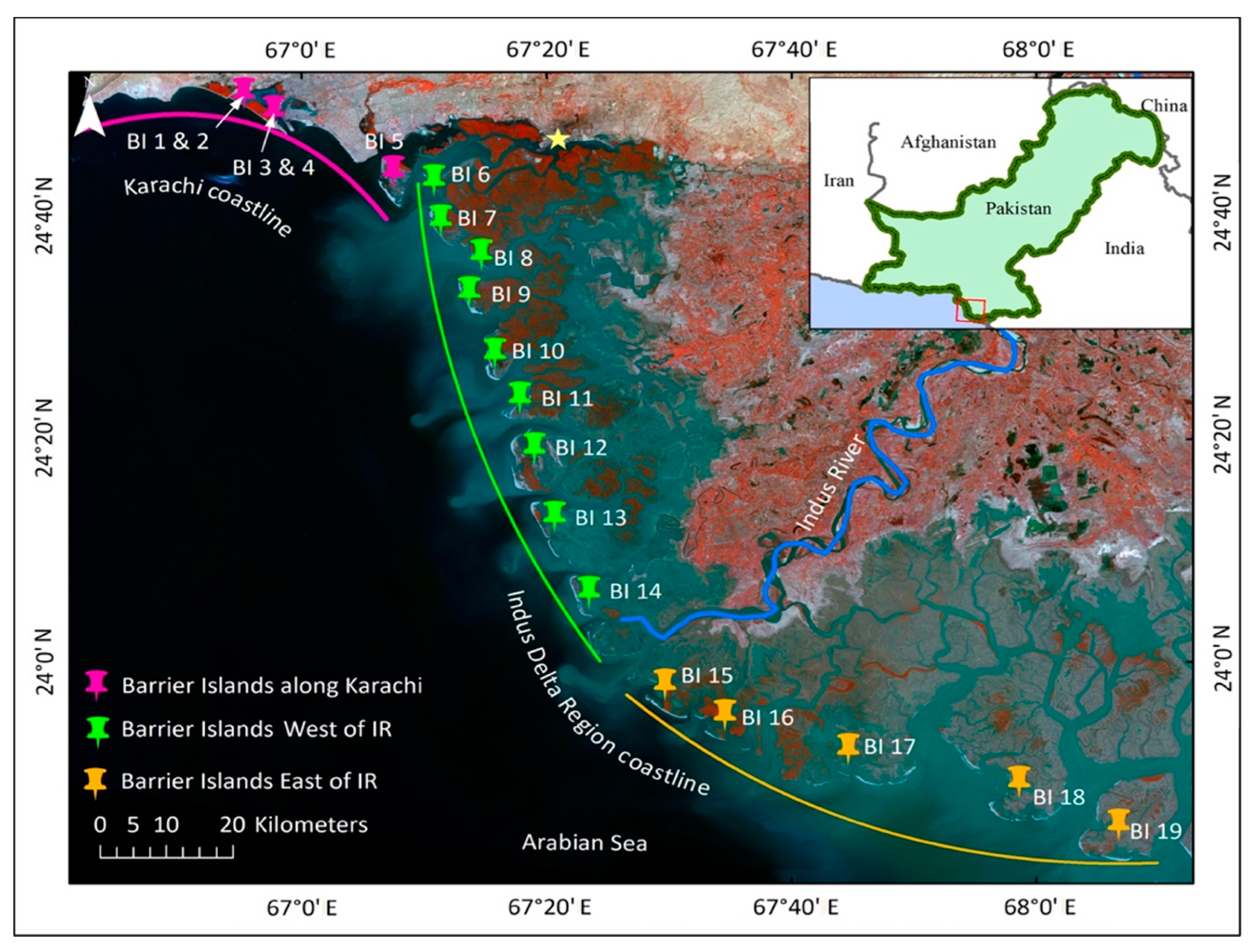
2. Study Area
3. Data Used
3.1. Satellite Data
3.2. Tide Height Data
3.3. Hydrodynamic Data
3.4. Sediment Discharge Data
3.5. Sea Levels Data
4. Methods
4.1. Step 1: BI Perimeter (Shoreline) Delineation
4.2. Step 2: BI Perimeter Change Rate Analysis and Implications to Coastal Planning and Development
5. Results
5.1. BI Perimeter Delineation
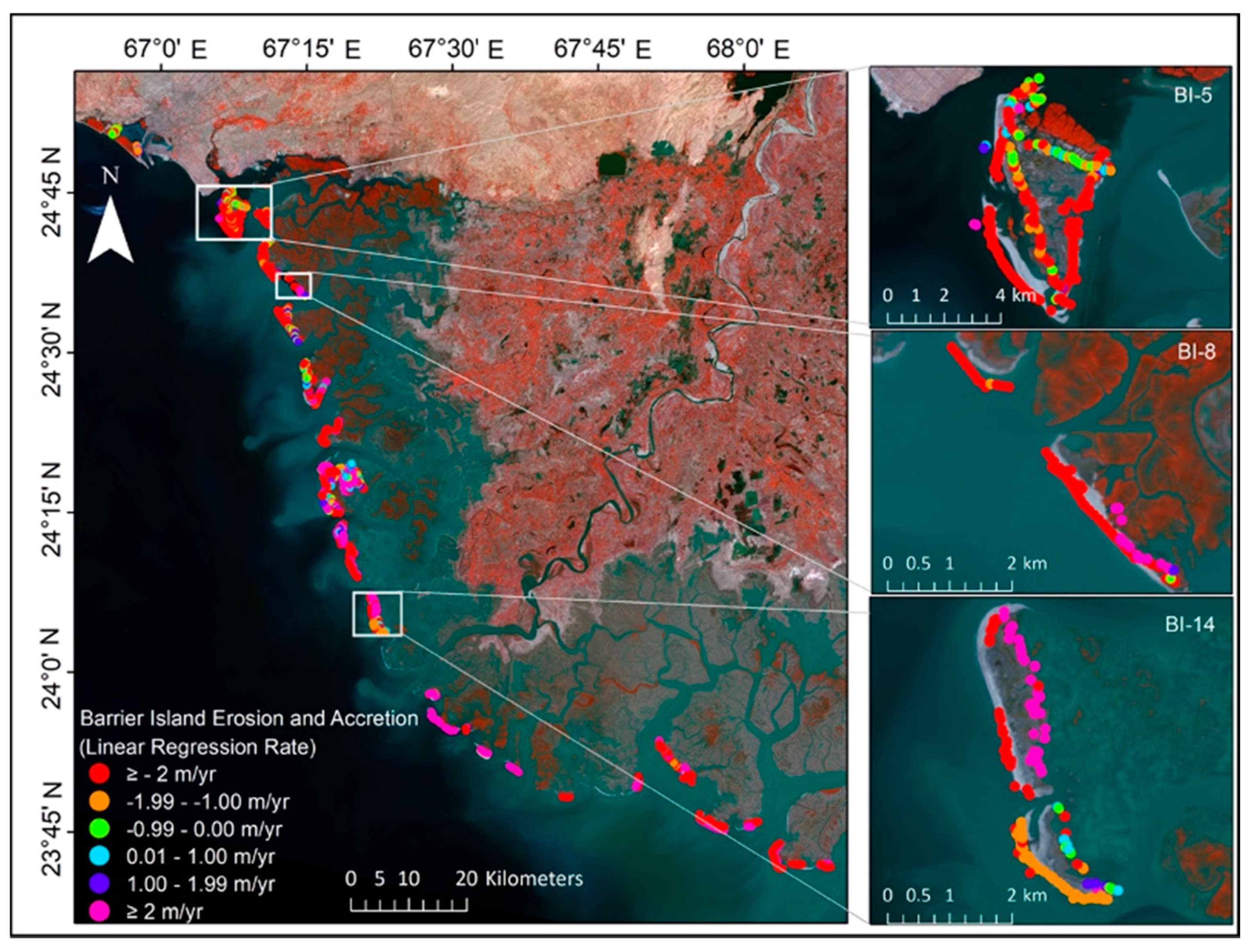
5.2. Rate of Shoreline Change in Different BIs
Transect Level Assessment of Erosion for Local Changes
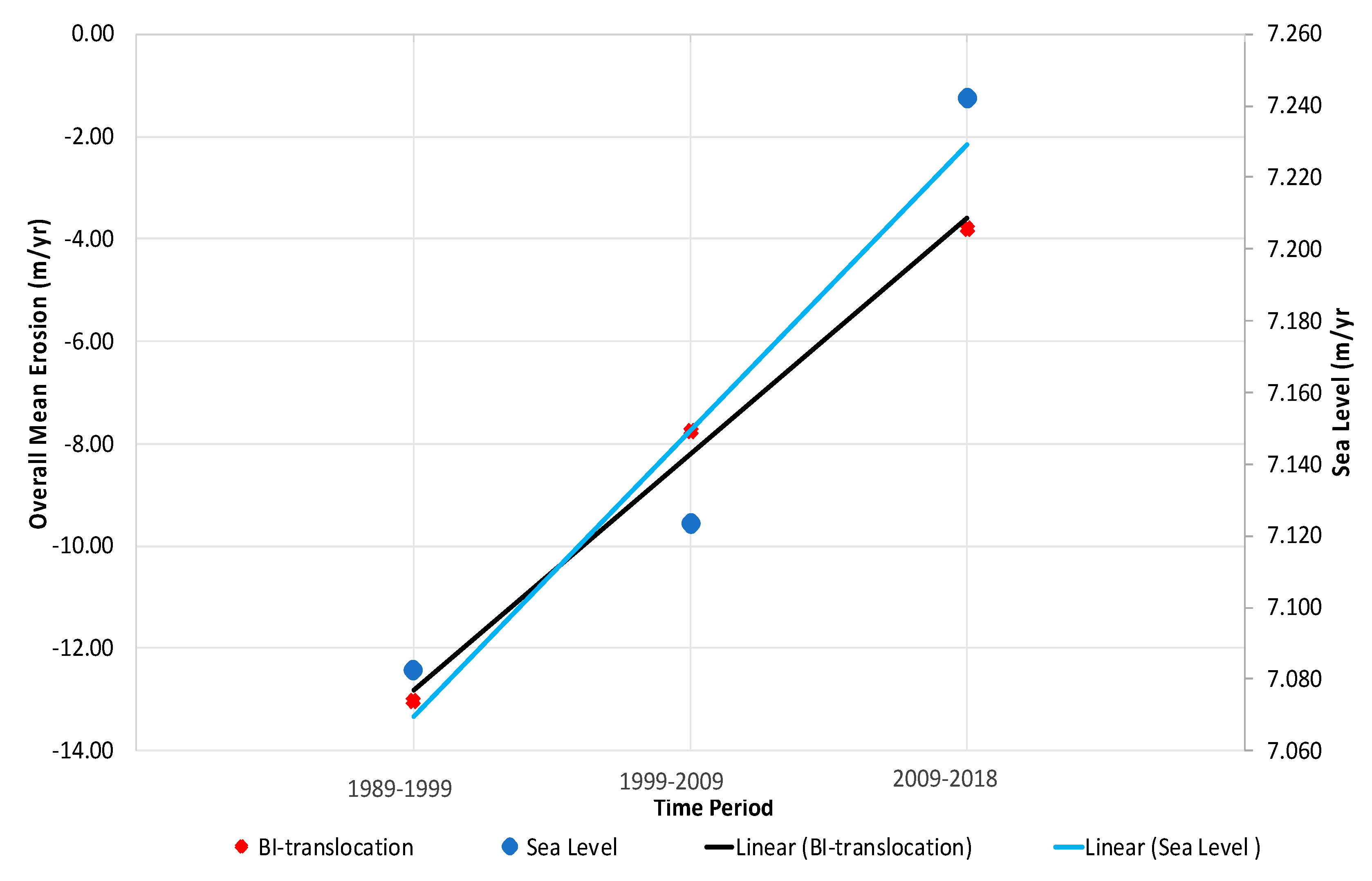
5.3. Interdecadal Translocation of BIs
6. Discussion
6.1. Hydrodynamics of the Study Area
6.2. Policy Implications for Coastal Management
6.3. Limitations and Future Directions
7. Conclusions
Supplementary Materials
Author Contributions
Funding
Institutional Review Board Statement
Informed Consent Statement
Data Availability Statement
Acknowledgments
Conflicts of Interest
References
- Brantley, S.T.; Bissett, S.N.; Young, D.R.; Wolner, C.W.V.; Moore, L.J. Barrier island morphology and sediment characteristics affect the recovery of dune building grasses following storm-induced overwash. PLoS ONE 2014, 9, e104747. [Google Scholar] [CrossRef] [PubMed]
- Feagin, R.A.; Smith, W.K.; Psuty, N.P.; Young, D.R.; Martínez, M.L.; Carter, G.A.; Lucas, K.L.; Gibeaut, J.C.; Gemma, J.N.; Koske, R.E. Barrier islands: Coupling anthropogenic stability with ecological sustainability. J. Coast. Res. 2010, 26, 987–992. [Google Scholar] [CrossRef]
- Powell, E.J.; Tyrrell, M.C.; Milliken, A.; Tirpak, J.M.; Staudinger, M.D. A review of coastal management approaches to support the integration of ecological and human community planning for climate change. J. Coast. Conserv. 2019, 23, 1–18. [Google Scholar] [CrossRef]
- Hapke, C.J.; Kratzmann, M.G.; Himmelstoss, E.A. Geomorphic and human influence on large-scale coastal change. Geomorphology 2013, 199, 160–170. [Google Scholar] [CrossRef]
- McBride, R.A.; Byrnes, M.R. Regional variations in shore response along barrier island systems of the Mississippi River delta plain: Historical change and future prediction. J. Coast. Res. 1997, 13, 628–655. [Google Scholar]
- Stutz, M.L.; Pilkey, O.H. Open-ocean barrier islands: Global influence of climatic, oceanographic, and depositional settings. J. Coast. Res. 2011, 27, 207–222. [Google Scholar] [CrossRef]
- Sajjad, M.; Li, Y.; Tang, Z.; Cao, L.; Liu, X. Assessing hazard vulnerability, habitat conservation, and restoration for the enhancement of mainland China’s coastal resilience. Earth’s Future 2018, 6, 326–338. [Google Scholar] [CrossRef]
- Xu, N. Detecting coastline change with all available landsat data over 1986–2015: A case study for the state of Texas, USA. Atmosphere 2018, 9, 107. [Google Scholar] [CrossRef]
- Griffiths, D.; House, C.; Rangel-Buitrago, N.; Thomas, T. An assessment of areal and transect-based historic shoreline changes in the context of coastal planning. J. Coast. Conserv. 2019, 23, 315–330. [Google Scholar] [CrossRef]
- Hein, C.J.; Fallon, A.R.; Rosen, P.; Hoagland, P.; Georgiou, I.Y.; FitzGerald, D.M.; Morris, M.; Baker, S.M.; Marino, G.B.; Fitzsimons, G. Shoreline dynamics along a developed river mouth barrier island: Multi-decadal cycles of erosion and event-driven mitigation. Front. Earth Sci. 2019, 7, 103. [Google Scholar] [CrossRef]
- Maiti, S.; Bhattacharya, A.K. Shoreline change analysis and its application to prediction: A remote sensing and statistics based approach. Mar. Geol. 2009, 257, 11–23. [Google Scholar] [CrossRef]
- Oost, A.; Hoekstra, P.; Wiersma, A.; Flemming, B.; Lammerts, E.; Pejrup, M.; Hofstede, J.; Van der Valk, B.; Kiden, P.; Bartholdy, J. Barrier island management: Lessons from the past and directions for the future. Ocean. Coast. Manag. 2012, 68, 18–38. [Google Scholar] [CrossRef]
- Shaw, J.B.; Wolinsky, M.A.; Paola, C.; Voller, V.R. An image-based method for shoreline mapping on complex coasts. Geophys. Res. Lett. 2008, 35. [Google Scholar] [CrossRef]
- Ghosh, M.K.; Kumar, L.; Roy, C. Monitoring the coastline change of Hatiya Island in Bangladesh using remote sensing techniques. ISPRS J. Photogramm. Remote Sens. 2015, 101, 137–144. [Google Scholar] [CrossRef]
- Nassar, K.; Mahmod, W.E.; Fath, H.; Masria, A.; Nadaoka, K.; Negm, A. Shoreline change detection using DSAS technique: Case of North Sinai coast, Egypt. Mar. Georesources Geotechnol. 2019, 37, 81–95. [Google Scholar] [CrossRef]
- Petropoulos, G.P.; Kalivas, D.P.; Griffiths, H.M.; Dimou, P.P. Remote sensing and GIS analysis for mapping spatio-temporal changes of erosion and deposition of two Mediterranean river deltas: The case of the Axios and Aliakmonas rivers, Greece. Int. J. Appl. Earth Obs. Geoinf. 2015, 35, 217–228. [Google Scholar] [CrossRef]
- Paris, P.J.; Mitasova, H. Geospatial contrasts between natural and human-altered barrier island systems: Core Banks and Ocracoke Island, North Carolina, USA. J. Coast. Conserv. 2018, 22, 679–694. [Google Scholar] [CrossRef]
- Moore, L.J.; List, J.H.; Williams, S.J.; Stolper, D. Complexities in barrier island response to sea level rise: Insights from numerical model experiments, North Carolina Outer Banks. J. Geophys. Res. Earth Surf. 2010, 115. [Google Scholar] [CrossRef]
- Williams, S.J.; Kulp, M.; Penland, S.; Kindinger, J.L.; Flocks, J.G. Mississippi River Delta Plain, Louisiana coast and inner shelf: Holocene geologic framework and processes, and resources. Gulf Mex. Orig. Waters Biota 2011, 3, 175–193. [Google Scholar]
- Cui, B.-L.; Li, X.-Y. Coastline change of the Yellow River estuary and its response to the sediment and runoff (1976–2005). Geomorphology 2011, 127, 32–40. [Google Scholar] [CrossRef]
- Li, X.; Damen, M.C. Coastline change detection with satellite remote sensing for environmental management of the Pearl River Estuary, China. J. Mar. Syst. 2010, 82, S54–S61. [Google Scholar] [CrossRef]
- Nienhuis, J.; Lorenzo-Trueba, J. Can barrier islands survive sea-level rise? Quantifying the relative role of tidal deltas and overwash deposition. Geophys. Res. Lett. 2019, 46, 14613–14621. [Google Scholar] [CrossRef]
- Sankar, R.D.; Donoghue, J.F.; Kish, S.A. Spatio-temporal analysis of decadal-scale patterns in barrier island response to storms: Perdido Key, NW Florida. Phys. Geogr. 2018, 39, 166–195. [Google Scholar] [CrossRef]
- Zhang, X.; Pan, D.; Chen, J.; Zhao, J.; Zhu, Q.; Huang, H. Evaluation of coastline changes under human intervention using multi-temporal high-resolution images: A case study of the Zhoushan Islands, China. Remote Sens. 2014, 6, 9930–9950. [Google Scholar] [CrossRef]
- Giosan, L.; Constantinescu, S.; Clift, P.D.; Tabrez, A.R.; Danish, M.; Inam, A. Recent morphodynamics of the Indus delta shore and shelf. Cont. Shelf Res. 2006, 26, 1668–1684. [Google Scholar] [CrossRef]
- Ijaz, M.W.; Mahar, R.B.; Ansari, K.; Siyal, A.A. Optimization of salinity intrusion control through freshwater and tidal inlet modifications for the Indus River Estuary. Estuar. Coast. Shelf Sci. 2019, 224, 51–61. [Google Scholar] [CrossRef]
- Ijaz, M.W.; Mahar, R.B.; Siyal, A.A.; Anjum, M.N. Geospatial analysis of creeks evolution in the Indus Delta, Pakistan using multi sensor satellite data. Estuar. Coast. Shelf Sci. 2018, 200, 324–334. [Google Scholar] [CrossRef]
- Kanwal, S.; Ding, X.; Sajjad, M.; Abbas, S. Three Decades of Coastal Changes in Sindh, Pakistan (1989–2018): A Geospatial Assessment. Remote Sens. 2020, 12, 8. [Google Scholar] [CrossRef]
- Fatima, H.; Arsalan, M.H.; Khalid, A.; Marjan, K.; Kumar, M. Spatio-temporal analysis of shoreline changes along Makran Coast using remote sensing and geographical information system. In Proceedings of the Fourth International Conference on Space Science and Technology (ICASE), Islamabad, Pakistan, 12–14 November 2019. [Google Scholar]
- Hashmi, S.; Ahmad, S. GIS-Based Analysis and Modeling of Coastline Erosion and Accretion along the Coast of Sindh Pakistan. J. Coast. Zone Manag. 2018, 21, 6–9. [Google Scholar] [CrossRef]
- Khan, T.M.A.; Razzaq, D.; Chaudhry, Q.-U.-Z.; Quadir, D.A.; Kabir, A.; Sarker, M.A. Sea level variations and geomorphological changes in the coastal belt of Pakistan. Mar. Geod. 2002, 25, 159–174. [Google Scholar] [CrossRef]
- Siddig, N.A.; Al-Subhi, A.M.; Alsaafani, M.A. Tide and mean sea level trend in the west coast of the Arabian Gulf from tide gauges and multi-missions satellite altimeter. Oceanologia 2019, 61, 401–411. [Google Scholar] [CrossRef]
- Waqas, M.; Nazeer, M.; Shahzad, M.I.; Zia, I. Spatial and Temporal Variability of Open-Ocean Barrier Islands along the Indus Delta Region. Remote Sens. 2019, 11, 437. [Google Scholar] [CrossRef]
- Mentaschi, L.; Vousdoukas, M.I.; Pekel, J.-F.; Voukouvalas, E.; Feyen, L. Global long-term observations of coastal erosion and accretion. Sci. Rep. 2018, 8, 12876. [Google Scholar] [CrossRef]
- Sajjad, M.; Chan, J.C.; Kanwal, S. Integrating spatial statistics tools for coastal risk management: A case-study of typhoon risk in mainland China. Ocean. Coast. Manag. 2019, 184, 105018. [Google Scholar] [CrossRef]
- Cenci, L.; Disperati, L.; Persichillo, M.G.; Oliveira, E.R.; Alves, F.L.; Phillips, M. Integrating remote sensing and GIS techniques for monitoring and modeling shoreline evolution to support coastal risk management. Gisci. Remote Sens. 2018, 55, 355–375. [Google Scholar] [CrossRef]
- Thieler, E.R.; Himmelstoss, E.A.; Zichichi, J.L.; Ergul, A. The Digital Shoreline Analysis System (DSAS) Version 4.0—An ArcGIS Extension for Calculating Shoreline Change; US Geological Survey: Reston, VA, USA, 2009. [Google Scholar]
- Davies, J. A morphogenic approach to world shorelines. Z. Geomorphol. 1964, 8, 127–142. [Google Scholar] [CrossRef]
- Rizvi, S.; Ali, A.; Naeem, S.; Tahir, M.; Baquer, J.; Saleem, M.; Tabrez, S. Comparison of the physical properties of seawater offshore the Karachi coast between the northeast and southwest monsoons. In Marine Science of the Arabian Sea; American Institute of Biological Sciences: Washington, DC, USA, 1988. [Google Scholar]
- Waheed-uz-Zaman, M.; Saif, N. To Study Feasibility of the Generation of Tidal Power Energy at Pakistan Creek Areas. J. Am. Sci. 2014, 10, 40–43. [Google Scholar]
- Mulhern, J.S.; Johnson, C.L.; Martin, J.M. Is barrier island morphology a function of tidal and wave regime? Mar. Geol. 2017, 387, 74–84. [Google Scholar] [CrossRef]
- Limmer, D.R.; Henstock, T.J.; Giosan, L.; Ponton, C.; Tabrez, A.R.; Macdonald, D.I.; Clift, P.D. Impacts of sediment supply and local tectonics on clinoform distribution: The seismic stratigraphy of the mid Pleistocene-Holocene Indus Shelf. Mar. Geophys. Res. 2012, 33, 251–267. [Google Scholar] [CrossRef]
- SWAN. SWAN Manual; Delft University of Technology: Delft, The Netherlands, 2018. [Google Scholar]
- Danish Hydraulic Institute (DHI). Danish Hydraulic Institute. MIKE 21 & MIKE 3 Flow Model FM, Hydrodynamic and Transport, Scientific Documentation; Danish Hydraulic Institute (DHI): Hørsholm, Denmark, 2016. [Google Scholar]
- Kidwai, S.; Ahmed, W.; Tabrez, S.M.; Zhang, J.; Giosan, L.; Clift, P.; Inam, A. The Indus Delta—Catchment, River, Coast, and People. In Coasts and Estuaries; Elsevier: Amsterdam, The Netherlands, 2019; pp. 213–232. [Google Scholar]
- Qiao, G.; Mi, H.; Wang, W.; Tong, X.; Li, Z.; Li, T.; Liu, S.; Hong, Y. 55-year (1960–2015) spatiotemporal shoreline change analysis using historical DISP and Landsat time series data in Shanghai. Int. J. Appl. Earth Obs. Geoinf. 2018, 68, 238–251. [Google Scholar] [CrossRef]
- Bartlett, D.; Smith, J. GIS for Coastal Zone Management; CRC Press: Boca Raton, FL, USA, 2004. [Google Scholar]
- Gornitz, V.M.; Daniels, R.C.; White, T.W.; Birdwell, K.R. The development of a coastal risk assessment database: Vulnerability to sea-level rise in the US Southeast. J. Coast. Res. 1994, 12, 327–338. [Google Scholar]
- MFF-Pakistan. A Handbook on Pakistan’s Coastal and Marine Resources; Ministry of Climate Change, Government of Pakistan: Islamabad, Pakistan, 2016.
- Frihy, O.; El-Sayed, M. Vulnerability risk assessment and adaptation to climate change induced sea level rise along the Mediterranean coast of Egypt. Mitig Adapt. Strat. Glob. Chang. 2013, 18, 1215–1237. [Google Scholar] [CrossRef]
- Mahapatra, M.; Ramakrishnan, R.; Rajawat, A. Coastal vulnerability assessment of Gujarat coast to sea level rise using GIS techniques: A preliminary study. J. Coast. Conserv. 2015, 19, 241–256. [Google Scholar] [CrossRef]
- Passeri, D.L.; Hagen, S.C.; Medeiros, S.C.; Bilskie, M.V.; Alizad, K.; Wang, D. The dynamic effects of sea level rise on low-gradient coastal landscapes: A review. Earth’s Future 2015, 3, 159–181. [Google Scholar] [CrossRef]
- Wamsley, T.V.; Cialone, M.A.; Smith, J.M.; Atkinson, J.H.; Rosati, J.D. The potential of wetlands in reducing storm surge. Ocean. Eng. 2010, 37, 59–68. [Google Scholar] [CrossRef]
- Temmerman, S.; Meire, P.; Bouma, T.J.; Herman, P.M.; Ysebaert, T.; De Vriend, H.J. Ecosystem-based coastal defence in the face of global change. Nature 2013, 504, 79–83. [Google Scholar] [CrossRef] [PubMed]
- Spalding, M.D.; Ruffo, S.; Lacambra, C.; Meliane, I.; Hale, L.Z.; Shepard, C.C.; Beck, M.W. The role of ecosystems in coastal protection: Adapting to climate change and coastal hazards. Ocean. Coast. Manag. 2014, 90, 50–57. [Google Scholar] [CrossRef]
- Silja, K.; Athanasios, T.V. Long-term adaptation planning for sustainable coasts. DIE ERDE J. Geogr. Soc. Berl. 2019, 150, 113–117. [Google Scholar]
- Domingues, R.B.; Santos, M.C.; de Jesus, S.N.; Ferreira, Ó. How a coastal community looks at coastal hazards and risks in a vulnerable barrier island system (Faro Beach, southern Portugal). Ocean. Coast. Manag. 2018, 157, 248–256. [Google Scholar] [CrossRef]
- Trujillo, A.P.; Thurman, H.V. Essentials of Oceanography, 12th ed.; Pearson: Dallas, TX, USA, 2016. [Google Scholar]
- Elsey-Quirk, T.; Graham, S.A.; Mendelssohn, I.A.; Snedden, G.; Day, J.W.; Twilley, R.; Shaffer, G.; Sharp, L.; Pahl, J.; Lane, R. Mississippi river sediment diversions and coastal wetland sustainability: Synthesis of responses to freshwater, sediment, and nutrient inputs. Estuar. Coast. Shelf Sci. 2019, 221, 170–183. [Google Scholar] [CrossRef]
- Irish, J.L.; Frey, A.E.; Rosati, J.D.; Olivera, F.; Dunkin, L.M.; Kaihatu, J.M.; Ferreira, C.M.; Edge, B.L. Potential implications of global warming and barrier island degradation on future hurricane inundation, property damages, and population impacted. Ocean. Coast. Manag. 2010, 53, 645–657. [Google Scholar] [CrossRef]
- Sutton-Grier, A.E.; Wowk, K.; Bamford, H. Future of our coasts: The potential for natural and hybrid infrastructure to enhance the resilience of our coastal communities, economies and ecosystems. Environ. Sci. Policy 2015, 51, 137–148. [Google Scholar] [CrossRef]
- Sajjad, M.; Chan, J.C. Risk assessment for the sustainability of coastal communities: A preliminary study. Sci. Total Environ. 2019, 671, 339–350. [Google Scholar] [CrossRef] [PubMed]
- Zhu, Z.-T.; Cai, F.; Chen, S.-L.; Gu, D.-Q.; Feng, A.-P.; Cao, C.; Qi, H.-S.; Lei, G. Coastal Vulnerability to Erosion Using a Multi-Criteria Index: A Case Study of the Xiamen Coast. Sustainability 2019, 11, 93. [Google Scholar] [CrossRef]


| Shoreline Segment | Administrative Units | Barrier Islands |
|---|---|---|
| Karachi | Karachi West | BI-1, BI-2, BI-3, BI-4 |
| Karachi South | BI-5 | |
| West of IR | Mirpur Sakro | BI-6, BI-7, BI-8, BI-9, BI-10, BI-11 |
| Ghorabari | BI-12 | |
| Keti Bandar | BI-13, BI-14 | |
| East of IR | Kharo-Chhann | BI-15, BI-16, part of BI-17 |
| Shah Bandar | Part of BI-17, BI-18, BI-19 |
| Data Set | Description | Period | Acquisition | Tide Height | Source | Software | |
|---|---|---|---|---|---|---|---|
| Time (UTC) | Date | ||||||
| Satellite data | Landsat TM | 1989–2018 | 05:26:11 | 3-April-1989 | 1.90 m | United States Geological Survey (https://espa.cr.usgs.gov/ (accessed on 31 December 2020)). | Envi 5.3, ArcMap 10.3 and Digital Shoreline Aanalysis System (DSAS) |
| 05:41:59 | 6-April-1999 | 2.5 m | |||||
| 05:44:13 | 10-April-2009 | 0.1 m | |||||
| Landsat OLI | 05:56:49 | 2-March-2018 | 2.80 m | ||||
| Tide Data | Mean tide level | 1989–2018 | - | - | - | Tides 4 Fishing (http://www.tides4fishing.com/ (accessed on 31 December 2020)) | |
| Hydrodynamic data | Wind/Wave | January–December | - | - | - | National Centers for Environmental Prediction | MIKE by DHI |
| Sediment Discharge data | IR discharge below Kotri barrage | 1989–2015 | - | - | - | Kidwai et al. [45] | Microsoft Excel 2016 |
| Sea Level data | Relative meansea levels | 1989–2015 | - | - | - | Permanent Service for Mean Sea Level (PSMSL) | Microsoft Excel 2016 |
| BI | No. of Transects | No. of Eroding Transects | No. of Accreting Transects | Eroding Transects (%) | Accreting Transects (%) | Disintegration of Island |
|---|---|---|---|---|---|---|
| 1 | 44 | 44 | 0 | 100 | 0 | No |
| 2 | 64 | 59 | 5 | 92 | 8 | No |
| 3 | 36 | 17 | 18 | 47 | 50 | No |
| 4 | 39 | 22 | 17 | 56 | 44 | No |
| 5 | 275 | 253 | 22 | 92 | 8 | Yes |
| 6 | 57 | 57 | 0 | 100 | 0 | No |
| 7 | 160 | 153 | 7 | 96 | 4 | No |
| 8 | 81 | 59 | 22 | 73 | 27 | Yes |
| 9 | 86 | 73 | 13 | 85 | 15 | No |
| 10 | 180 | 124 | 56 | 69 | 31 | Yes |
| 11 | 70 | 57 | 13 | 81 | 19 | No |
| 12 | 349 | 155 | 194 | 44 | 56 | Yes 1 |
| 13 | 218 | 135 | 83 | 62 | 38 | No 1 |
| 14 | 157 | 80 | 77 | 51 | 49 | Yes 1 |
| 15 | 126 | 64 | 62 | 51 | 49 | Yes 1 |
| 16 | 86 | 29 | 57 | 34 | 66 | Yes 1,2 |
| 17 | 96 | 73 | 23 | 76 | 24 | Yes 1,2 |
| 18 | 229 | 161 | 68 | 70 | 30 | Yes 1 |
| 19 | 177 | 114 | 63 | 64 | 36 | Yes 1 |
| Total | 2530 | 1729 | 800 | 68 | 32 | - |
| BI | 1989–1999 | 1999–2009 | 2009–2018 | Trend |
|---|---|---|---|---|
| 1 | −1.86 | −0.43 | −0.32 | ↓ |
| 2 | −4.44 | 0.562 | −2.30 | ↓↑ |
| 3 | −1.75 | 0.85 | −4.63 | ↓↑ |
| 4 | −6.42 | 5.84 | −0.39 | ↓↑ |
| 5 | −24.46 | −2.48 | −8.91 | ↓↑ |
| 6 | −9.64 | −18.01 | −18.01 | ↑ |
| 7 | −32.04 | −22.69 | −7.89 | ↓ |
| 8 | −1.82 | −9.12 | −1.70 | ↓ |
| 9 | −24.36 | −7.58 | −4.28 | ↓ |
| 10 | −13.79 | −1.50 | 4.12 | ↓ |
| 11 | −18.81 | −9.83 | −20.63 | ↓↑ |
| 12 | −6.27 | −7.49 | 2.94 | ↑↓ |
| 13 | −15.55 | −5.74 | 8.44 | ↓ |
| 14 | −6.66 | −2.86 | −0.37 | ↓ |
| 15 | −10.90 | −0.96 | 5.52 | ↓ |
| 16 | −16.65 | 5.383 | 3.54 | ↓ |
| 17 | −42.008 | −41.922 | −25.49 | ↑ |
| 18 | 9.50 | −11.9 | −1.82 | ↓ |
| 19 | −19.75 | −17.594 | −0.17 | ↓ |
Publisher’s Note: MDPI stays neutral with regard to jurisdictional claims in published maps and institutional affiliations. |
© 2021 by the authors. Licensee MDPI, Basel, Switzerland. This article is an open access article distributed under the terms and conditions of the Creative Commons Attribution (CC BY) license (http://creativecommons.org/licenses/by/4.0/).
Share and Cite
Kanwal, S.; Ding, X.; Sajjad, M.; Nazeer, M.; Zia, I. Remote Sensing of Narrowing Barrier Islands along the Coast of Pakistan over Past 30 Years. J. Mar. Sci. Eng. 2021, 9, 295. https://doi.org/10.3390/jmse9030295
Kanwal S, Ding X, Sajjad M, Nazeer M, Zia I. Remote Sensing of Narrowing Barrier Islands along the Coast of Pakistan over Past 30 Years. Journal of Marine Science and Engineering. 2021; 9(3):295. https://doi.org/10.3390/jmse9030295
Chicago/Turabian StyleKanwal, Shamsa, Xiaoli Ding, Muhammad Sajjad, Majid Nazeer, and Ibrahim Zia. 2021. "Remote Sensing of Narrowing Barrier Islands along the Coast of Pakistan over Past 30 Years" Journal of Marine Science and Engineering 9, no. 3: 295. https://doi.org/10.3390/jmse9030295
APA StyleKanwal, S., Ding, X., Sajjad, M., Nazeer, M., & Zia, I. (2021). Remote Sensing of Narrowing Barrier Islands along the Coast of Pakistan over Past 30 Years. Journal of Marine Science and Engineering, 9(3), 295. https://doi.org/10.3390/jmse9030295