1. Introduction
At the present stage of regional oil and gas exploration in the Arctic, much attention is given to studies of the deep structure of sedimentary basins in conjunction with studies of the consolidated basement underlying them. Such an approach allows the assessment of the age interval and geodynamic settings of the platform cover formation, the morphology of these structures, and the nature of the tectonic dislocations.
At the present level of regional geological and geophysical studies of the Russian Federation and adjacent continental shelf development of new methodological approaches to the geotectonic modeling of structural and compositional inhomogeneities of the Earth’s crust, their geodynamic and evolutionary interpretation, and the implementation of regional forecast-mineragenic estimates for various types of ore and nonmetallic minerals, are of particular relevance.
The lithosphere-scale 3-D structural model of the Barents Sea and Kara Sea region of Klitzke et al. [
1,
2] was the first attempt to combine information about sediments, crystalline crust and lithospheric mantle.
This model refines the four main mega-sequence boundaries: the bottom of the upper crystalline crust, the Moho, and the calculated lithosphere–asthenosphere (LAB) boundary.
The Northern (1) and Southern (2) Kara Sea, the Eastern (3) and Western (4) Barents Sea, and the oceanic domain comprising the Norwegian–Greenland Sea and the Eurasia Basin (5) are the five main offshore areas. The western Barents Sea is underlain by a thin (~80 km) lithosphere. It was formed through multiple Phanerozoic rifting phases and/or the opening of the Atlantic starting from Paleocene/Eocene times onwards.
The most important results of the development of the structural model [
3] for the assessment of petroleum potential relate to the South-West Barents Sea and show a classical rift system with major extensional faults.
More recent research resulted in the compilation of a tectonic map of the Arctic [
4] that shows the age and main structural features of coastal and oceanic sedimentary basins of the Barents, Kara, Laptev, East Siberian, and Chukotka Seas [
5]. The basement structure of these basins and Arctic islands is also discussed.
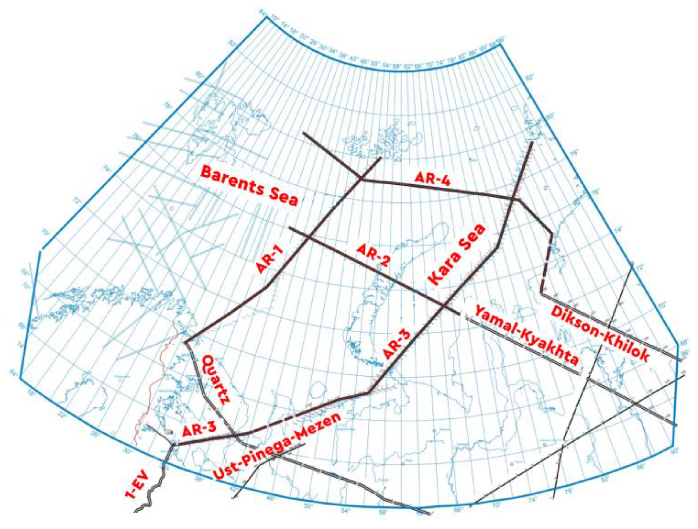
The database of regional investigations of the deep structure of the crust, tectonics, and geodynamics of sedimentary basins and fold areas includes refraction and reflection (CDP) seismic data, deep seismic sounding (DSS) data, magnetotellurics (MT), audio magnetotellurics (AMT) sections, digital potential fields, and remote sensing data. Geological mapping results and geological and geophysical studies of wells were also used to inform our interpretations. These were collected in the framework of government programs of reference regional geophysical profiles (geo-traverses), regional-scale geological mapping, and regional geological studies of main geo-economical regions (
Figure 1).
Within the framework of investigations of the Russian sector of the Eurasian Arctic, we have carried out geotectonic interpretation of the regional seismic profiles of the Barents-Kara Sea region: “AR-1”, “AR-2”, “AR-3” and “AR-4” (
Figure 1) [
6]. These data were acquired by the State Enterprise “Sevmorgeo”. We have also interpreted multiple geophysical datasets collected along regional deep seismic sounding (DSS) profiles “Quartz”, “Yamal-Kyakhta”, “Dikson-Khilok”, as well as the reflection seismic data acquired by “Spetsgeofizika” along “1-EV” and “Ust-Pinega-Mezen” profiles. The regional geoelectric, gravity and magnetic data were utilized to inform our interpretations [
7].
2. Research Methodology
The process of our investigations included several stages, from the processing of geophysical data to their qualitative and quantitative interpretation followed up by the compilation of geological-structural schemes [
7].
We model the deep structure of the Earth’s crust underlain by a layer of the lithospheric mantle [
7] based on geological and geophysical data. In our approach, we distinguish the volcanogenic-sedimentary layer and consolidated crust. The crust is divided into upper crustal (granite-metamorphic), middle crustal, and lower crustal layers. In some cases, the last two layers are combined into a single lower crustal layer.
In our research, we have encountered two serious methodological problems:
Large differences in the morphology of platform cover structures and of consolidated basement and information overload of maps of deep structure which, in essence, are geotectonic, and which simultaneously reflect the structure of both sedimentary cover and basement. This cartographic problem is resolved by compiling layer-by-layer maps of the deep structure and deep sections of the Earth’s crust using single ideology and unified legend.
An extensive time interval of the formation and subsequent evolution of platform cover and consolidated basement structures of the Eurasian Arctic. To solve this problem, a geotectonic approach is applied to the process of the modeling of structural and compositional inhomogeneity of the Earth’s crust.
The key construction tool in this methodology is a zonal-block model of the lithosphere [
8] based on the results of specialized processing and comprehensive interpretation of seismic (DSS and CDP), gravimetric, magnetic, geoelectric, and geothermal data. It reflects blocks and inter-block zones separating them. Blocks are characterized by regionally stable areas of geophysical fields and derived parameters; inter-block zones—by gradient zones, or zones of drastic change in the potential field pattern and infrastructure of parameters calculated from potential field data. In the resulting tectonic model, blocks correspond to palaeo-plates and microplates of continental lithosphere, inter-block zones—to deep tectonic sutures that have resulted from extension (rifts), compression (sutures of collision orogens), or strike-slip movements [
7].
In our geotectonic modelling of basement structures, we relied on one of the most generally accepted principles of tectonic zoning based on the age of the final folding. According to Khain [
9], time boundaries of geotectonic cycles reflect the periodic consolidation of continental lithosphere into a single supercontinent, or the partial closure of an ocean due to periodic collisions of volcanic island arcs with continents (Bertrand cycles).
One of the assessment methods of the oil and gas potential [
10] of sedimentary basins is evolutionary-genetic, based on the concept that each complex and heterogeneous modern basin is a system of laterally and vertically conjugated palaeo-basins of a certain tectonotype, or relicts of such palaeo-basins [
7,
11]. Each sedimentary basin has formed in certain geodynamic regimes and went through a long geological evolution. At certain stages of basin development, favorable geological, geochemical, and thermobaric conditions have emerged that determine the processes of oil and gas formation and their redistribution between various complexes composing these palaeo-basins, as well as processes of partial or complete destruction of oil and gas accumulations. Late stages of basin formation have the greatest impact on the current distribution of hydrocarbon accumulations [
9,
12,
13].
Accordingly, each basin of the primary evolutionary-genetic sequence is characterized by a certain oil and gas formation regime. The concept of oil and gas formation regime, according to Sokolov [
14], includes conditions of basin evolution caused by type and movements of the crust, duration of subsidence, rate of sediment accumulation, direction of tectonic movements (vertical or horizontal), their contrast and ratio and basin thermal history.
The petroleum geology regime of a basin defines specific features of source rock and reservoir formation, their relationship in the vertical section, and the timing of oil and gas maturation. It also defines the location of oil and gas palaeo-accumulation zones and their temporal and spatial relations in the process of the spatial and vertical distribution of oil and gas accumulations.
Changes in the geodynamic conditions of basin formation and, consequently, changes in their genetic types lead to the transformation of petroleum geology regimes that ultimately reflect oil and gas potential. As noted by most researchers, oil and gas formation regimes differ in sedimentary basins located within continents, oceans, and transition zones. In turn, within continents, sedimentary basins of platforms and mountain-folded areas have fundamentally different regimes [
14,
15,
16,
17].
Consequently, it is important to consider the fact that the sedimentary basin is a part of a larger evolving system. The scale of oil and gas accumulation also varies significantly, ranging from high/very high (20–63%) within sedimentary basins of young plates and folded platform basins in marginal parts of cratons, to low (3%) in post-orogenic depressions on Precambrian Midlands, and very low (less than 1%) in orogenic inter-mountain depressions on the epivariscian folded basement.
Alongside with tectonic reconstructions based on regional seismic data interpretation in the western-most part of the Russian Arctic sector, a conventional basin analysis was performed to clarify the assessment of the hydrocarbon potential. The assessment is based on the presence and distribution of source and reservoir rocks, as well as on the impact of tectonic events and major unconformities on hydrocarbon reservoir integrity. The assessment incorporates evaluations of the presence and distribution of oil source and reservoir rocks, and the impact of tectonic events and major unconformities on hydrocarbon reservoir integrity. The study results are based on conventional basin analysis.
We have subdivided sedimentary cover into seismo-stratigraphic complexes, correlated and linked geological and geophysical data onshore and offshore, and compiled a series of structural maps for several reflection horizons (RH) in areas of their identification from the top of the basement (RH VI) to the bottom of Jurassic (RH B). A seismo-geological model was used to refine the tectonic and oil and gas zoning of the North of the Timan-Pechora province, including Pechora Sea.
3. Structure and Composition of the Earth’s Crust of the Arctic Sector of Eurasia
The main parameters of the Earth’s crust of the region are characterized by tectonic schemes of consolidated basement, platform cover, and deep sections of the crust. The schemes and sections were compiled within a unified legend and can be considered as a 3D geotectonic model of the region.
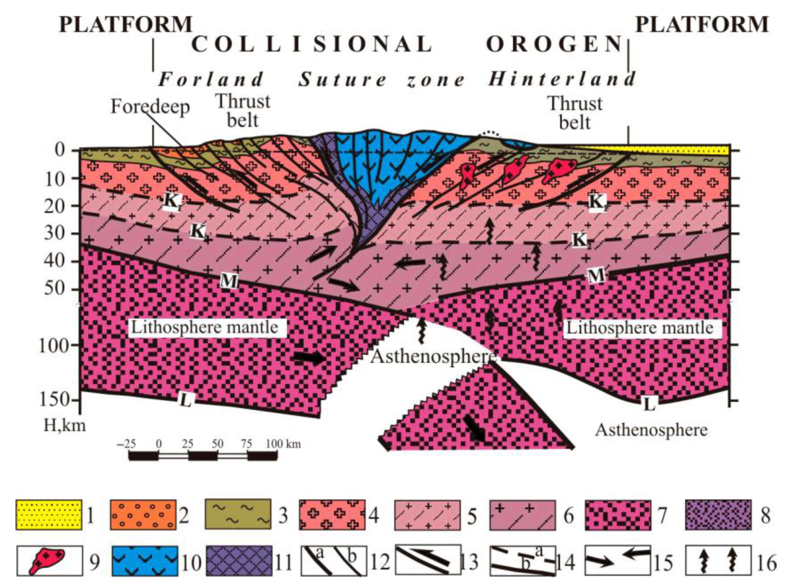
The most common geodynamic setting of the consolidated crust is a collisional orogen, which is formed in the process of the collision of continents or microcontinents with each other, possibly involving the collision of enzymatic island arcs. They generally correspond to a deformed margin of the submerging plate (fold-thrust belt and foredeep), or a suture zone, marking the position of the former oceanic basin, or the deformed margin of the overlapping plate (
Figure 2) [
7].
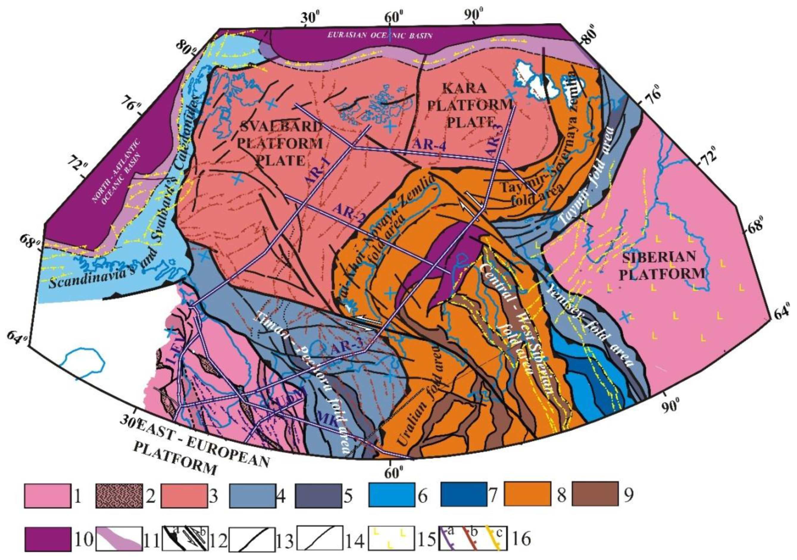
The tectonic zonation of the consolidated basement was carried out according to the time of the principal fold deformations (final folding) (
Figure 3) [
7].
The Eurasian sector of the Arctic includes the northern part of Europe and Western Asia and the adjacent areas of the Atlantic and Arctic oceans. Divergent plate boundaries are drawn along the Mid-Atlantic spreading ridge and the Gakkel Ridge in the Arctic Ocean.
The most ancient structures of the region are East European and Siberian cratons and Kara and Svalbard platform plates with an ancient Precambrian (Grenvillian) basement. These structures are separated by fold belts: Timan-Pechora, Yenisei and Taimyr Baikalian fold areas; Caledonian structures of Norway, West Spitsbergen, and Altai-Sayan fold areas; Uralian, Central West Siberian, and Taymir-Severnaya Zemlya Hercynian fold areas; Early Cimmerian Paikhoi-Novaya Zemlya fold area [
18].
Within the ancient platforms and fold areas, suture zones are mapped. They mark the position of closed riftogenic and oceanic basins and fold-thrust belts formed on the edges of lithospheric plates and microplates.
The suture zones, which separate crustal blocks of various structures, are marked by outcrops of ophiolites and island arc complexes. In the vertical section, such zones have a wedge-shaped morphology and a narrow deep channel. As a result of the collision, the edges of the plates are affected by intense compressional deformations. In the process of collision, the thickness of the brittle upper crust can sharply increase due to the injection of the plastic lower crust and tectonic clustering of the upper crust. This phenomenon of the formation of “mountains roots” is visible in the sections of the Yenisei Khatanga (
Figure 4) and Ural fold areas. Typical structures of collisional orogens are tectonic nappes resulting from the abduction of oceanic and island-arc formations on the continental margins (
Figure 2). Molasse strata often accumulate within marginal troughs [
7].
Our study area contains a broad range of rifts, the ages of which vary from Riphean to Mesozoic and Cenozoic. In all cases, these structures are formed by an association of sedimentary and volcanic rocks. Morphologically, these are structures of fault-bounded grabens.
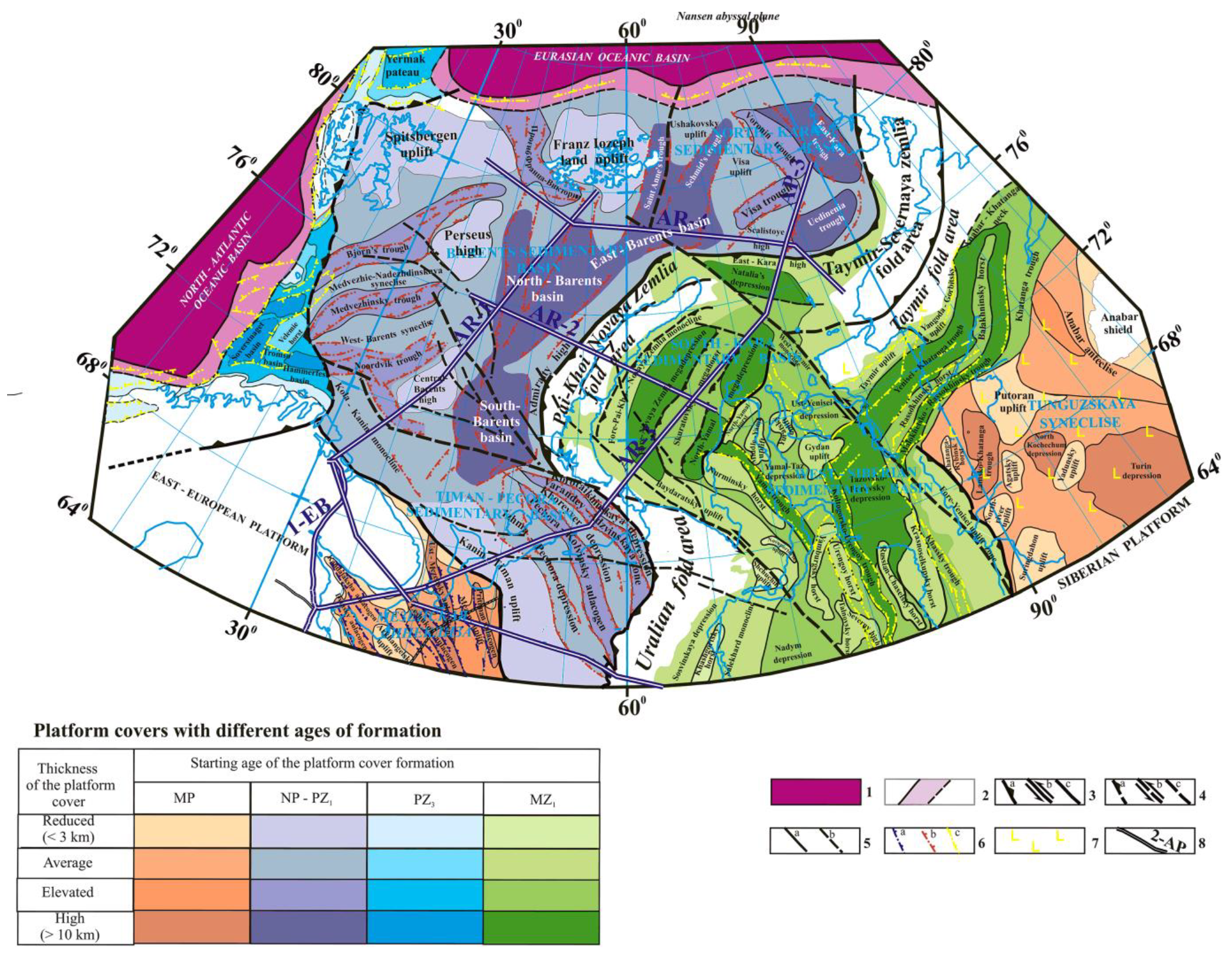
The tectonic scheme of the platform cover shows features of the upper structural level filled with weakly lithified, weakly deformed platform sediments overlying the consolidated basement (
Figure 4).
The largest structural elements in the scheme are sedimentary basins. The color is assigned to the age interval of the cover formation; the intensity of the color depends on its relative thickness. The scheme presents four age intervals of the formation of sedimentary basins: 1—Riphean-Mesozoic sediments of the East European and Siberian cratons; 2—Paleozoic-Cenozoic sediments on the Baikalian (Timan-Pechora fold area) and Grenville (platform plates of Svalbard and Kara) basements; 3—Late Paleozoic-Cenozoic sediments formed on the Caledonides of Scandinavia and West Spitsbergen; 4—Mesozoic-Cenozoic sediments of the West Siberian, South Kara and Yenisei Khatanga sedimentary basins, overlying a consolidated basement of different ages. In the basal part of the West Siberian geo-syneclise, formations of the so-called “intermediate structural level” are distinguished. They are composed of weakly dislocated moderately lithified complexes of the Riphean and Paleozoic age.
The scheme reflects the position of rifts of different ages, which are most often inherited by post-rift troughs, often covering vast territories of platform plates. Anteclises, syneclises, shafts, domes, local uplifts, and structures are presented on the scheme. Special attention is paid to the manifestations of intraplate deformations (
Figure 4).
4. Features of the Deep Structure of the Region
East European and Siberian ancient platforms were formed in the process of the Paleoproterozoic accretion of Archean palaeo-plates [
9]. Their basement is mainly composed of the old Archean blocks and Paleoproterozoic suture and riftogenic zones. The results of geophysical studies of the suture zones reflect the fold-and-thrust nature of their deformations, often with an inclined deep inter-block channel.
The Svalbard and North Kara platform plates are interpreted as fragments of the Grenville platform, called “Hyperborea” by Shatskiy [
19] or “Arctida” by Zonenshain and Natapov [
20]. Khain suggested [
9] that a platform with a Grenville or even older basement existed in the center of the Arctic in the late Precambrian and Early Paleozoic. Their separation took place at the beginning of the Paleozoic during the disintegration of the Rodinia supercontinent. Fragments of this platform are the Svalbard and Karsky platform plates, the structures of Northern Taimyr, and the Lomonosov, Alpha, and Mendeleev ridges [
21]. Within the Arctic Basina, Early Proterozoic crystalline formations are exposed in the east of Spitsbergen and the north of Novaya Zemlya. It is assumed that these outcrops constitute the visible part of the basement, the top parts of which are of Middle Proterozoic age.
The tectonic structure of the consolidated basement of the Eurasian sector of the Arctic is determined by the nature and sequence of accretion of the Svalbard, Bolshezemelskaya, the Baltic, Kara, and Siberia paleo-plates, and numerous microplates.
The Svalbard Platform Plate is interpreted as a Precambrian (Grenvillian) platform with an ancient consolidated basement and Paleozoic-Mesozoic sedimentary cover.
Consolidated basement. Isotope dating of the Grenville (1150–960 Ma) age of the basement formations was established by Gee et al. [
22] in Svalbard. According to seismic survey data on reference and regional profiles, the Grenville basement can be tracked to the southeast from Spitsbergen towards the outer limits of the Kola monocline and the borders of the Timan-Pechora region [
7], and to the east—towards the Central block of Novaya Zemlya, and further to the area of the North Kara syneclise. The thickness of the consolidated crust within the Svalbard (Barents) plate varies from 18 to 36–38 km. The most radical reductions in crustal thickness, caused by the processes of its extension, are noted within the East Barents mega-trough. The results of geophysical studies indicate the continental type of crust and significant basification. In the most submerged parts, a positive bend of the Moho boundary is noted, and crust-mantle transition zones up to 10 km thick have been identified [
23].
Platform cover. The data on the geological structure and composition of the litho-stratigraphic strata of the cover were obtained in the Novaya Zemlya archipelago, Franz Josef Land, and Spitsbergen. Reference wells in the hydrocarbon fields of the East Barents Basin intersect the full section of the Mesozoic sediments and part of the Upper Paleozoic sediments. According to seismic data, Early Paleozoic deposits deformed to varying degrees are distinguished. They are included in the acoustic basement [
24].
The East Barents Sea basin consists of three main basins: South Barents (20 km thick), North Barents (18 km thick), and St. Anna (15 km thick). It is assumed that the main volumes of sedimentation within the basin were formed in the process of the Late Devonian (Frasnian-Famenian) rifting and subsequent post-rift subsidence [
12,
25,
26,
27]. Combined interpretation of CDP seismic data and borehole studies indicates the development of an echeloned system of grabens and half-grabens at the base of the basin, filled with clastic and volcanic deposits with a total thickness of 1.5 to 3.0 km overlying the Early-Middle Paleozoic "acoustic basement". Repeated rifting may have occurred in the Permian-Triassic. Post-rift subsidence led to the formation of up to 1.0–1.5 km deep depression by the end of the Permian. In the Early Triassic, the deep-water basin was rapidly filled with sediments. From the Middle Triassic to the Late Cretaceous marine, shallow-sea and continental environments developed in the axial parts of the East Barents Sea basin [
23].
A characteristic section of the eastern flank of this structure is the section along the AR-2 profile. The Barents fold area in this section is represented by the North-Barents depression covering the thinned transition crust of passive continental margin type. Such sections are characterized by the development of all three layers of the classical continental crust with reduced thickness due to rifting. Rifting zones within the depression have a characteristic pattern of “pure shear” deformations with a centric distribution of the faults (
Figure 5).
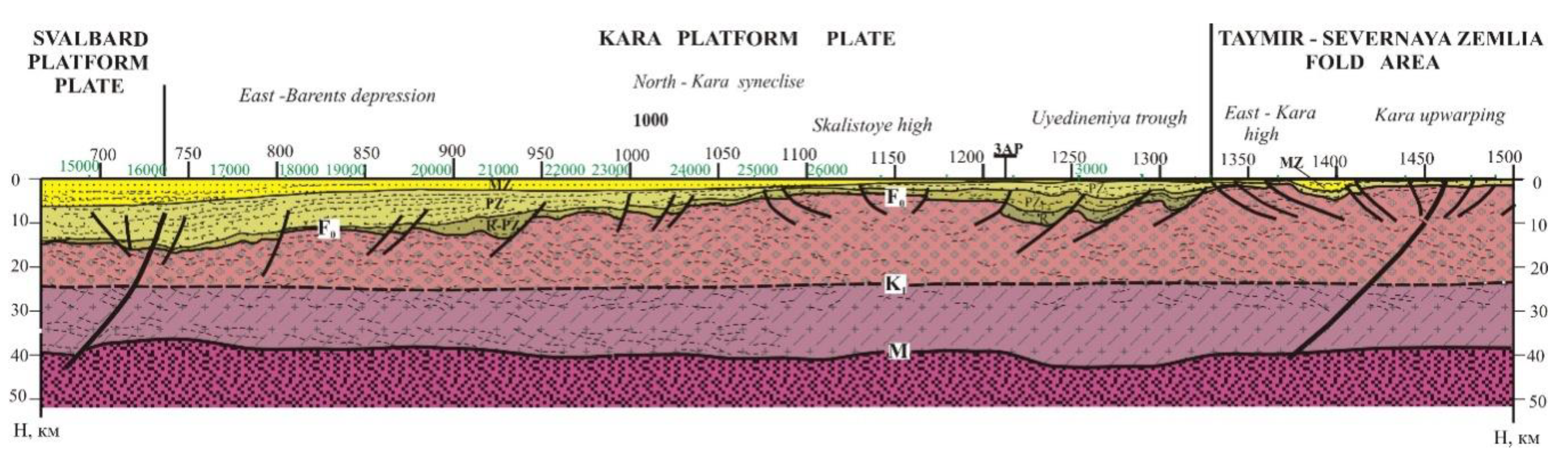
The Kara platform plate is interpreted as a Precambrian (Grenvillian) platform with an ancient consolidated basement and Paleozoic-Mesozoic sedimentary cover. It has been crossed by a large number of regional seismic profiles and two reference geophysical profiles (geo-traverses) AR-3 and AR-4, acquired by state enterprise Sevmorgeo. In combination with data from the geological mapping of the Severnaya Zemlya archipelago, even in the absence of deep drilling wells here, there is an opportunity to carry out deep crustal geological and structural modelling.
The consolidated basement on the islands of Severnaya Zemlya is mainly composed of deformed and metamorphosed shales and sandstones of the Neoproterozoic–Cambrian age [
12]. Neoproterozoic granite plutonism is represented by the intrusions of south-eastern October Revolution Island [
4,
17].
The North Kara sedimentary basin is characterized by a thick (on average more than 5 km) sedimentary cover, increasing in troughs to 15–16 km and reducing to 2–4 km within individual uplifts (e.g., Vize-Ushakova and others). In its southwestern part, the East Barents Basin is identified with a total sediment thickness of up to 14–16 km. To the north, there is the St. Anna’s trough, which overlaps the joint of the Svalbard and Kara platform plates and the Schmidt trough. On the eastern and southern flanks of the basin, the East Kara and Uedineniya troughs are mapped. Depressions and troughs are separated by uplifts.
Lower Ordovician volcanic-clastic rocks at the base of the sedimentary cover of graben-type depressions overly deformed folded sediments of the acoustic basement. This formation is associated with rift extension [
12,
25,
28]. According to the geological mapping of the Severnaya Zemlya archipelago, Early Paleozoic rifting resulted in the formation of volcanic rocks (andesites, trachytes, and rhyolites) along the N-trending fracture system [
4,
29].
The composition of the sedimentary cover of the troughs varies according to different authors. According to Daragan-Suscheva et al. [
30,
31,
32], the section is dominated by the Upper Riphean-Middle Paleozoic rocks that form two structural levels—the Upper Riphean-Cambrian and Ordovician-Devonian. In the modern shelf area, a series of relatively deep-water basins separated by shallower areas existed during the Upper Riphean and Vendian [
33]. In these narrow basins, up to 7–9 km of mainly flysch-like terrigenous strata have accumulated. The thickness of the Ordovician-Devonian cover reaches 6 km.
Startseva [
34] distinguishes Ordovician-Devonian and Carboniferous-Mesozoic structural levels in the sedimentary cover of the basin. Martirosyan et al. [
35] divided the sedimentary cover into two structural levels: (1) the lower one, up to 14–15 km thick, covering the upper Proterozoic and almost the entire (or all) Paleozoic, moderately dislocated and filled with lower terrigenous and upper carbonate complexes; and (2) upper, presumably Mesozoic, represented by terrigenous mainly continental deposits. Their thickness in the east is in hundreds of meters, in the west it increases to 2 km, and in the St. Anna Trough it reaches 6–8 km.
Ordovician to Devonian sediments are deformed by platform-type dislocations [
36]. Martirosyan et al. note the widespread development of faults in the Paleozoic part of the sedimentary sequence with an amplitude of 2–3 km [
35]. They are mostly interpreted as normal faults.
The deep structure of the Kara plate is illustrated by a fragment of the reference geophysical profile (geo-traverse) AR-4 (
Figure 6). In this region, the East Barents Basin filled with deposits from Early Paleozoic to Cenozoic has the largest total thickness of the sedimentary cover (up to 16 km). It has reduced thickness of the Earth’s crust (up to 38 km to the background of 40–42 km in adjacent blocks). A sparce grid of deep faults slightly disrupting the continuity of seismic horizons is observed in the lower horizons of the sedimentary cover. Within the Rocky Rise, the thickness of the sedimentary cover is reduced to a few kilometers, possibly due to intraplate compression caused by Hercynian accretion in the adjacent Taimyr-Severozemelskaya fold zone.
On the southeastern flank of the Kara plate, a large increase in the thickness of the platform cover up to 10 km is noted. Seismic features and solutions of the inverse problem of gravity and magnetic field interpretation in this part of the AR-4 geo-traverse suggest the development of a system of Paleozoic riftogenic structures in this area. These structures define the morphology of sedimentary strata typical for troughs.
The Baikalian folding epoch from the end of Proterozoic to the beginning of Cambrian is represented in the study area by structures of the Timan-Pechora, Taimyr, and Yenisei Khatanga fold zones.
The formation of the Timan-Pechora fold zone is associated with the Late Baikalian accretion of the passive margin of the Baltic palaeo-plate, Upper Pechora island arc, and the Bolshezemelskaya palaeo-plate. Since the Ordovician, the region has been developing as a passive margin of the Uralian palaeo-ocean. On tectonic schemes (
Figure 3 and
Figure 4), a series of aulacogens is identified as linearly elongated depressions of increased mobility, limited by large faults and horst structures. Its deep structure is studied onshore along the DSS profile “Murmansk-Kyzyl” (Quartz) (
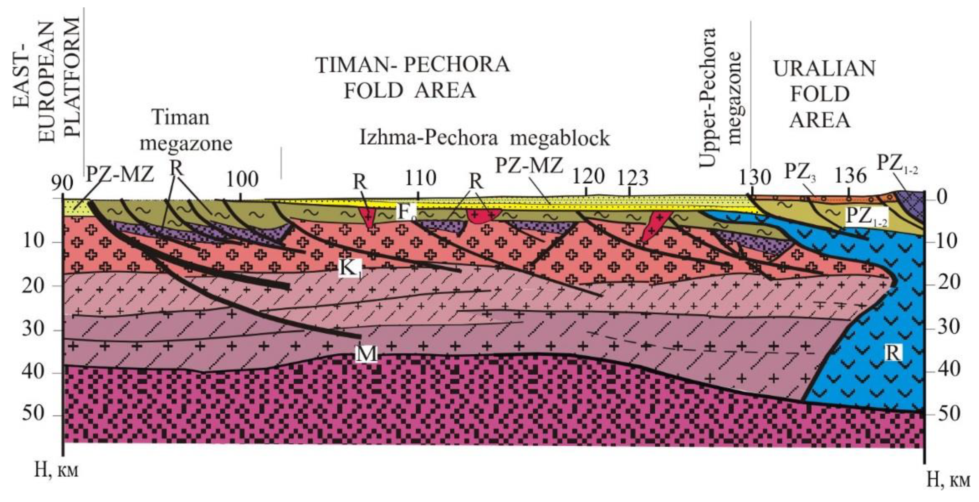
Figure 7), and offshore—along the CDP AR-3 geo-transect.
There are four main structures identified in this region. The Timan mega zone corresponds to the Riphean rift of the passive margin of the Baltic, which underwent intense fold-thrust deformations with the uplift of Riphean sediments to the surface at the final stages of the Baikalian tectonic-magmatic cycle. The Izhma-Pechora mega block is also formed on the passive rift margin of the Baltic. Metamorphosed sediments of Riphean shelf up to 10–12 km thick are deformed here by Baikalian folds and thrusts and are overlain by the Paleozoic-Mesozoic platform cover. The Upper-Pechora mega zone with an anomalous (according to the DSS and other geophysical studies) structure of the Earth’s crust is filled with deformed Riphean volcanic-sedimentary complexes of an island arc. During the Baikalian orogeny, these complexes were obducted on the margins of adjacent continental blocks. The Bolshezemelskiy mega block is interpreted as an ancient palaeo-plate of the continental type accreted to the Baltic at the final stage of the Baikalian tectonic-magmatic cycle. The overall tectonic pattern of the fold area is controlled by the dominant northwest-striking dislocations. The deep section shows the pinching out of most of the tectonic deformations within the upper crust (
Figure 7).
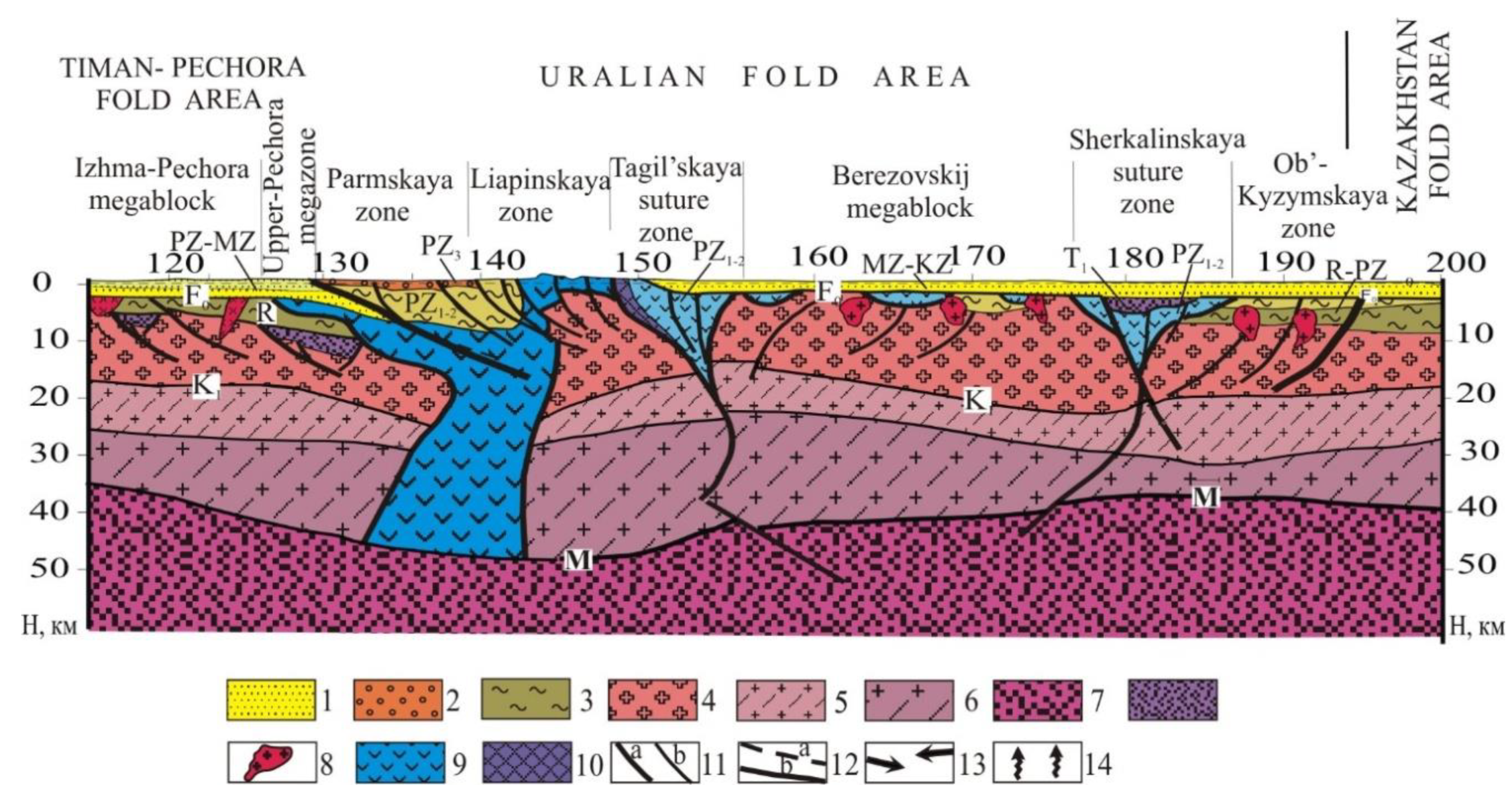
The Ural fold belt was formed in the process of the Hercynian orogeny (Late Palaeozoic) due to the accretion of Baltic and Kazakhstan palaeo-plates and a series of microplates and island arcs. The overall deep structure of this region is consistent with the model of collisional orogen of the Uralian type. Its distinctive feature is a series of microplates with continental-type crust and suture zones (
Figure 8).
In the cross-section of the DSS “Murmansk-Kyzyl” profile, the Uralian fold area, from northwest to southeast, includes structures of the Western Urals: (a) intensely deformed margin of the Barents platform; (b) Tagilo-Magnitogorsk suture zone, modeled as a wedge-shaped synform filled with Paleozoic volcanic-sedimentary complexes; (c) the East Ural mega block overlain by sediments of the West Siberian geosyneclise on the Precambrian continental crust; (d) Sherkalin suture zone; and (e) Ob-Kyzym deformed margin of the Khanty-Mansi mega-block, which is a part of the Kazakhstan palaeo-plate.
The Central West Siberian fold area is fully covered by sediments of the West Siberian geosyneclise. Its formation is associated with the Late Paleozoic accretion of the Kazakhstan and Siberian palaeo-plates. The section includes the deformed margins of the Kazakhstan and Siberian palaeo-continents and the inter-block Irtysh-Zaysan suture mega zone at the site of the closed Asian palaeo-ocean.
The Taimyr-North-Zemlya fold area covers the area of the Late Paleozoic accretion of the Siberian and Kara palaeo-continents, which led to the formation of the Hercynian fold area and the deep erosion of the Ordovician-Devonian complexes [
30]. The northern boundary of the orogen is the Late Paleozoic thrust front mapped on the islands of Severnaya Zemlya. The southern boundary is the Late Paleozoic fold structures of the Northern Taimyr, where intense thrust tectonics and the intrusion of post-collisional granites are documented. In northern Tajmyr, metasedimentary successions are partly magmatised and extensively intruded by 305 Ma age granites, which mark the age of the accretion of the Kara microcontinent to Siberia. Bio-stratigraphic observations indicate that the Severnaya Zemlya deformation took place in the latest Devonian to earliest Carboniferous. The Taimyr margin of the Siberian continent, defined by Zonenshain et al. [
20] and Vernikovsky et al. [
37] as the main Paleozoic suture, does not contain allochthonous oceanic terranes. Unconformably overlying Late Paleozoic continental and coastal-marine rocks of the Early Carboniferous-Permian age have been documented at some locations in the Severnaya Zemlya archipelago [
4]. Thin Mesozoic poorly cemented sediments occur on the Paleozoic consolidated basement in this area.
Late Paleozoic to Early Mesozoic magmatic activity is manifested as mafic dykes and subordinate sills on Bolshevik Island. One K-Ar age definition of the intrusions (222 ± 15 Ma) is available [
4]. Petrological and geochemical characteristics suggest a close connection of these rocks with the trap magmatism of Tajmyr and Siberia in Late Permian-Early Triassic time [
4]. Jurassic and Cretaceous non-marine strata are documented in northern-most Tajmyr and many small islands in the Kara Sea [
36].
The section along the AR-4 geo-traverse (
Figure 5) shows the uplift of the Hercynian consolidated basement within the fold zone, and the development of a thin Upper Paleozoic-Triassic sedimentary cover. In the deepest troughs, the thickness of the sedimentary cover does not exceed 4 km. On the sides of the trough, the thickness of sediments decreases to the first hundreds of meters. A centriclinal system of faults is mapped in the section.
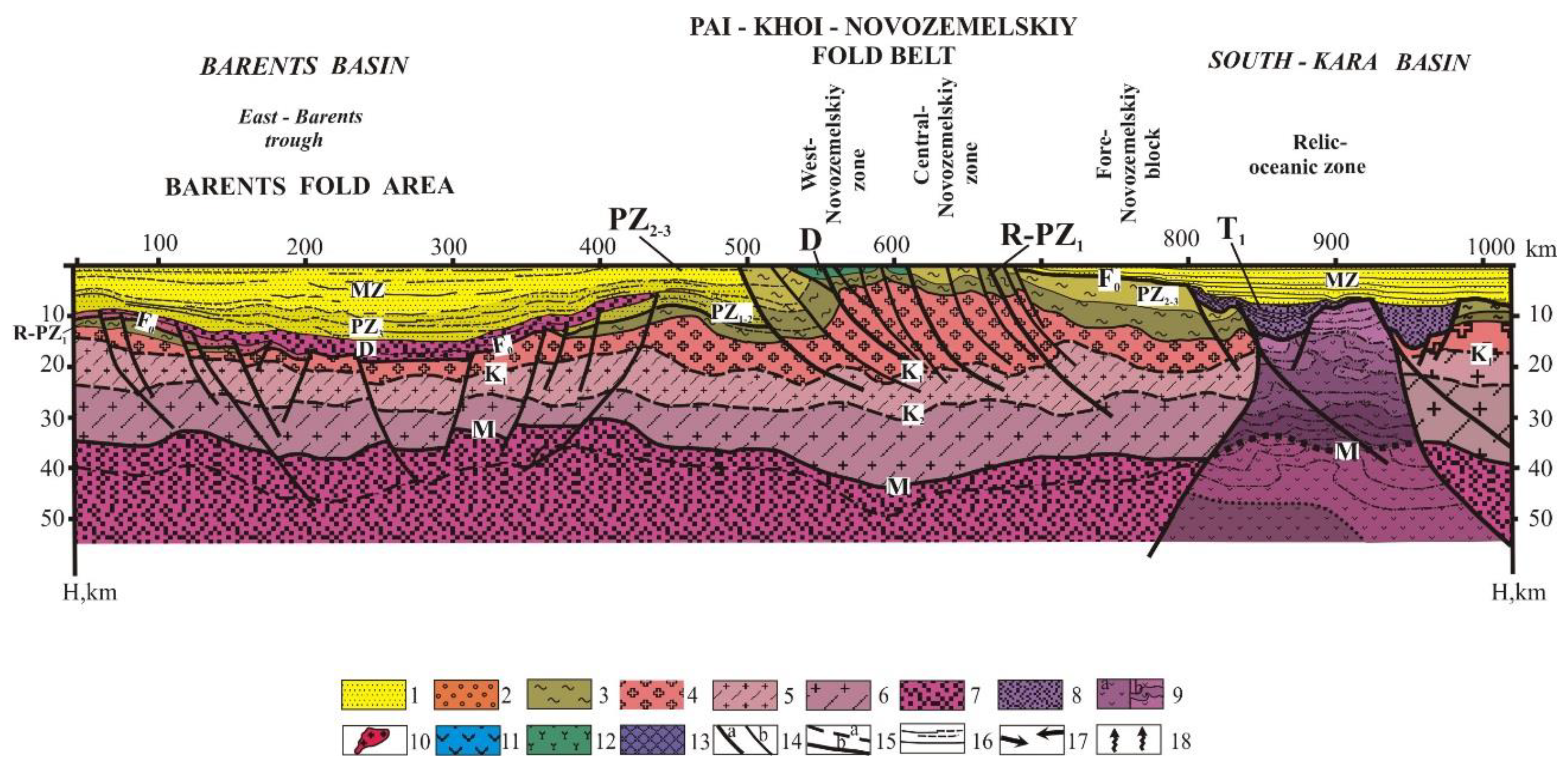
The Paikhoisk-Novozemelskaya fold area was formed at the initial phase of the Cimmerian tectogenesis (Late Triassic-Jurassic). The zonation of the fold area is not typical for a classical collisional orogen: it is located on the margin of the Svalbard Plate and does not have a distinct foredeep and suture zones. Here, the intensity of fold-thrust deformations decreases eastward, and metamorphism is confined to the zones of deep Main Novaya Zemlya and Central Novaya Zemlya faults. Fold-block and thrust dislocations occurred along these and similar fault zones. Numerous Middle Jurassic-Early Cretaceous paleontological occurrences in the northern part of Yuzhny Island of the Novaya Zemlya archipelago indicate the existence of a wide strait in this area at that time, and, therefore, the structural plan of the region at that time was strongly disturbed.
In the section of the AR-2 geotraverse (
Figure 6), deep sediments of the western flank of the Paikhoisk-Novozemelskaya fold belt have a similar composition to those in the North Barents Basin, which allows us to define the long-term development of these structures as occurring in similar geodynamic settings of passive continental margin type.
The south-eastern flank of the profile intersects the structure of the South Kara sedimentary basin with a total thickness of the sedimentary cover up to 16 km. Judging by indirect geophysical characteristics (thickness of the crust, character of its layering, and velocity parameters), the basin is located on remnant oceanic crust. The basal part of the sedimentary layer is represented by the Paleozoic sediments of continental slope. They are covered by sediments of moderately deep seas and the volcanic-sedimentary formation of rifting basins (D3-J1). Continental and coastal marine clay-clastic Jurassic-Cenozoic sediments were identified in the upper part of the section.
The West Siberian young platform occupies the area of the West Siberian lowland and the shelf of the Kara Sea. Since the Mesozoic, this was a large area of subsidence filled with horizontally lying cover of Mesozoic and Cenozoic sediments, up to 4–6 km thick, overlying a strongly deformed basement. At the base of the platform sedimentary cover, there are Triassic volcanic-sedimentary formations that fill the rift system and complexes of the so-called "intermediate structural level (ISL)”. Within Caledonian fold areas (Kazakhstan and Altai-Sayan), complexes of the late Paleozoic age belong to the ISL. On the Baikalian fold basement in the Yenisei Khatanga and Taimyr fold area, the ISL includes the full Paleozoic section. On the flanks of the Siberian platform, the ISL also includes Riphean deposits.
5. Tectonic Controls on Petroleum Potential of the Western Russian Arctic
Analysis of the petroleum resources distribution in the world’s sedimentary basins of different genetic types confirms that the richest ones are the basins of young internal plates and folded-platform basins. The less rich ones are the large collisional basins of inter-mountain depressions superimposed on the central massifs, and the poor ones are the late and post-orogenic inter-mountain depressions on a folded basement.
Within the northeastern margin of the European Platform [
36], some researchers identify a single heterogeneous Pechora-Barents Sea oil and gas basin (mega-basin) of the terra-aquatic type [
12], while most others consider the Pechora and Barents Sea basins as two separate sedimentary basins.
These basins correspond to the domain of relatively stable long-term subsidence of the Earth’s crust. The composition, structure, and burial conditions of sedimentary rock complexes of varying age that have formed during this process defined the formation, accumulation and preservation of commercially valuable oil and gas fields.
The Pechora-Barents Sea basin is an integrated dynamically developing system, in most of which sedimentation still goes on. The older sediment complexes are expressions of palaeo-basins. The generation, migration, accumulation, and conservation of hydrocarbons continue in this basin in corresponding thermodynamic regime. All these processes are inter-linked within the concept of oil and gas ontogenesis.
According to its structural-tectonic position, the Pechora-Barents Sea basin belongs to marginal-plate structures located at the forefront of the Ural and Paikhoisk-Novozemelskaya fold-thrust domains, and its development is linked to a stage of evolutionary growth of heterogeneous basins.
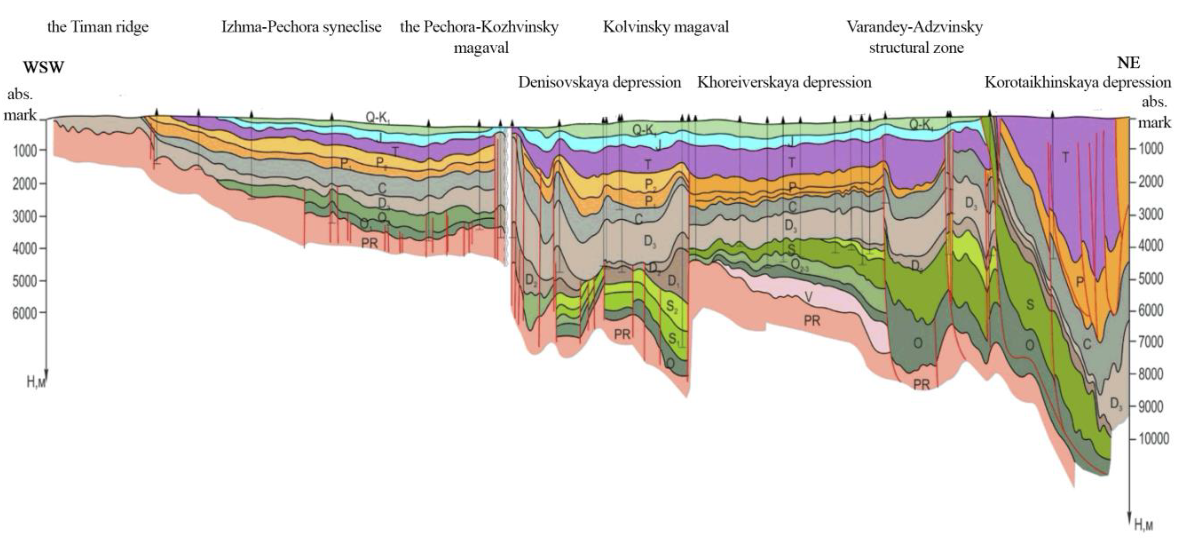
The Pechora-Barents Sea sedimentary basin also belongs to the category of peri-platform resonant formations to a certain extent, but it was formed on a younger basement in co-evolution with the Ural and Paikhoisk-Novozemelskaya fold-thrust areas. This ultimately determined the specifics of the sediment composition and many similarities and differences between the Western Arctic basins in spatial and depth distribution of hydrocarbons. The southern part of the Pechora-Barents Sea basin has formed on top of the pre-existing late Precambrian basin at the boundary of the Epibaykal plate. Its northern part has formed on the Epigrenville basement. This predetermined an active inherited tectonic development of the basin with up to 10–12 km thick sediments in the Timan-Pechora, and up to 16–18 km thick sediments in the Barents Sea parts.
The depth to heterogeneous basements of different ages (or to the bottom of non-dislocated platform swdiments) in the Pechora-Barents Sea basin varies from 0.5–1.0 km on its Western Kola-Kanin-Timan side, to 16–18 km, or possibly more, in the South Barents and North Barents basins. The reliability of interpretations, as reflected in the structural map of the basement surface, is higher onshore than offshore. In the Timan-Pechora sub-basin, the basement is accessible for drilling at 3–6 km depth in a large area, and the results obtained by geophysical methods are strongly linked to data from deep wells.
The complex of geophysical data allows us to confidently track the basement structures of the Pechora syneclise on the adjacent shelf at a depth of 6–10 km to the north towards the line connecting the Kanin peninsula and Mezhdusharsky Island. Further to the northwest, between this line and the South Barents rift we have identified a structural boundary limiting the area, within which the presence of the Baikal basement structures is still identified by some geophysical markers, but not by all of them.
The entire southeastern part of the Barents Sea (Pechora Sea), together with the adjacent area onshore, is a single structural element—the Pechora syneclise. The Pechora syneclise is bounded in the south-west by the slope of the Timan-Kanin ridge incorporating folded structures of the Baikalian age, and in the north-west by the flank of the South-Barents depression.
The Timan-Pechora region is commonly accepted as the area tectonically corresponding to the Timan-Pechora Epibaikalian plate and to peri-cratonal deepening of the consolidated baicalide structures that replace this plate in the East. These consolidated baicalide structures are covered at present by rock formations of the Ural trough, Paikhoisk-Novozemelskaya fold-thrust region, and Western and Axial (Central) mega zones of the Urals.
The western boundary of the basin, manifested by the chain of disjunctive folds of the Timan ridge, is the Western Timan thrust (suture rift). The Epibaikalian plate borders with the Epikarelian Russian plate: its eastern and north-eastern parts border the Main Urals and Baydaratsky deep rifts, respectively.
The Main Urals rift marks the boundary between (a) the Baikalian rocks submerged under the complex structures of the Western/Central Urals on predominantly continental crust, and (b) the Eastern Urals, where upper Proterozoic-Hercynian relics of the oceanic and island-arc crust are assumed to exist. The second rift, presumably of a shear nature, separates the Timan-Pechora basin from the South Kara basin of the West Siberian plate, which has a pre-Mesozoic basement that was repeatedly altered. The Northern limit of it may be the Kurentsovskaya flexure of the North Pechora Sea monocline, with a discharge-shift that is in contact with the Barents-North Kara sedimentary basin underlain by the Grenville-Baikalian basement.
The modern structure of the Timan-Pechora sedimentary sub-basin formed at the beginning of the Late Cretaceous, but the main stages of its formation were completed in the early Jurassic. The tectonic structure of the basin is determined by the final relationships of structural and formation divisions (structural floors and sub-floors). These relationships are characterized by structural maps of surfaces of corresponding divisions.
Given that the sedimentary cover incorporates several structural floors, a structural map of the diachronic surface of upper-Visean to lower Permian carbonates was selected for morphology-based tectonic zoning. It corresponds to the section of pre-orogenic structural floors that have formed during pre-orogenic (early and middle Hercynian) and orogenic (late Hercynian) stages of tectogenesis.
This map most adequately reflects the structural development of the Phanerozoic tectonic epochs. The upper-Visean–lower Permian carbonate complex, identified as an oil and gas-bearing one, dominates in the sedimentary cover in terms of initial total hydrocarbon resources. The diachronic surface of upper-Visean–lower Permian carbonates is a good seismic reflection horizon (RH I) and a reasonable approximation of the topography of the pre-orogenic carbonate strata on local anomaly gravity field maps. Dimensions and the subordination of tectonic elements determined their position in the hierarchical sequence. To justify zone boundaries, we have taken into consideration possible hydrocarbon migration paths and conditions of sedimentation.
A necessary condition for hydrocarbon generation, alongside the presence of enriched organic matter (OM) formations, is a certain degree of its catagenesis due to geothermal regime. The main geochemical parameters, alongside paleotectonic analysis, allow the identification of the formation and development of oil and gas maturation domains, as well as the identification of oil and gas accumulation areas in the Timan-Pechora region.
Modern assessment of the oil and gas potential of the Western Arctic is based on a complex of geochemical, lithology-facies, structural, and other studies. It also incorporates tectonic prerequisites and tectonic schemes created by a group of authors led by Dedeyev [
13,
38] and later modified for the purposes of oil and gas formation zoning [
39].
The Barents Sea (BS) and Kara Sea (KS) belong to the Western-Arctic shelf. The KS shelf and the Yamal Peninsula form a single Yamal-Kara region (YKR), which occupies the northwestern part of the West Siberian mega-basin (WSMB) and the oil and gas-bearing mega province of the same name (WSMP). The shelf of the southern part of the Barents Sea (Pechora Sea) occupies the northern part of the Timan-Pechora oil and gas province.
The identified hydrocarbon potential of the Western Arctic seas of Russia as of 01/01/2019 is represented [
40] by 19 fields, most of which are located within the Kara Sea bays. Some of them are shelf extensions of onshore fields, and some are located offshore in the Barents Sea.
All identified oil and gas fields are concentrated in two areas offshore: (1) the Barents Sea with mostly gas fields, and its southern part—the Pechora Sea, with mostly oil fields, and (2) the Kara Sea (mostly gas and gas condensate fields) [
28,
41]. The volume of proven oil reserves in these areas is relatively small: 454 million tons, 96% of which is concentrated in licensed fields. Projected oil resources are estimated at 12.8 billion tons, of which only 5% are concentrated in licensed areas [
11,
42,
43].
Total proven gas reserves are much larger: 9.2 trillion m
3, of which almost 70% are in the fields that are partly covered by existing licenses [
17,
44,
45,
46]. The inferred resources of natural gas are estimated at 86.5 trillion m
3, of which only ~ 4% are located within licensed areas [
34,
42,
47].
Until recently, the Barents and Pechora seas shelf was characterized by the highest level of geological and geophysical studies among the seas of the Russian Arctic, both at the regional and exploration stages. Regional and detailed 2D CDP seismic surveys covering more than 420,000 line km were carried out here. According to the results of geophysical studies, 75 structures of various degrees of investigation have been identified so far in the Barents Sea, excluding its southern part, the Pechora sea [
42].
The basement of the Yamal-Kara sub-basin, which belongs to the north-western Arctic regions of the West Siberian mega-basin, has a Hercynian consolidation age (early Permian epoch) and is composed of a variety of strongly altered, mostly metamorphic rocks: clay shales, limestones, etc.
A large volume of regional seismic surveys has been carried out in the southern part of the Barents Sea (Pechora Sea) and in its junction with the onshore part of the Timan-Pechora province from 2008 to 2018. A significantly refined geological and geophysical model of the structure of the northern part of the Timan-Pechora oil and gas province, including its offshore extension into the Pechora Sea, has resulted from this work. A significant basis for the revision of the geological model of the lower Paleozoic section is the results of the parametric Severo-Novoborskaya-1 well.
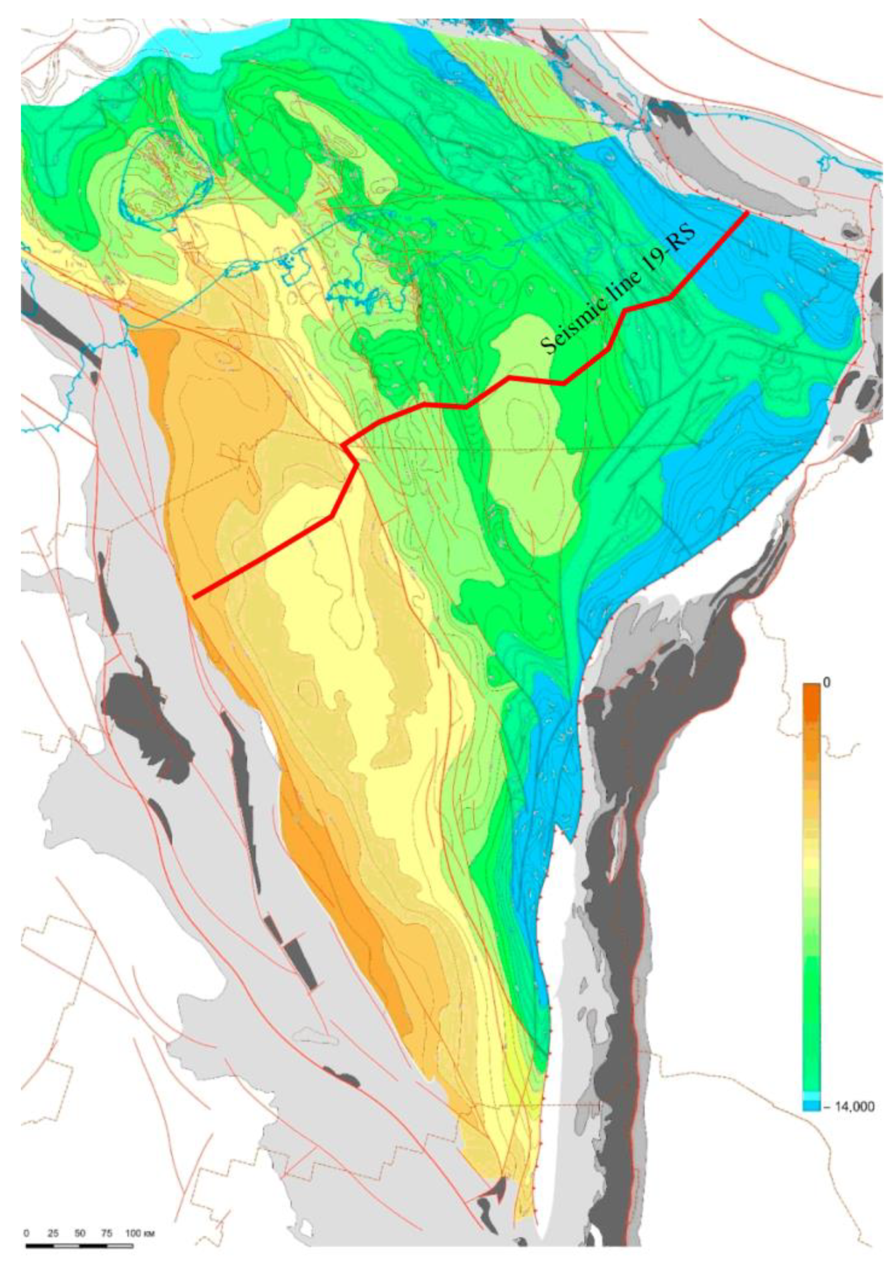
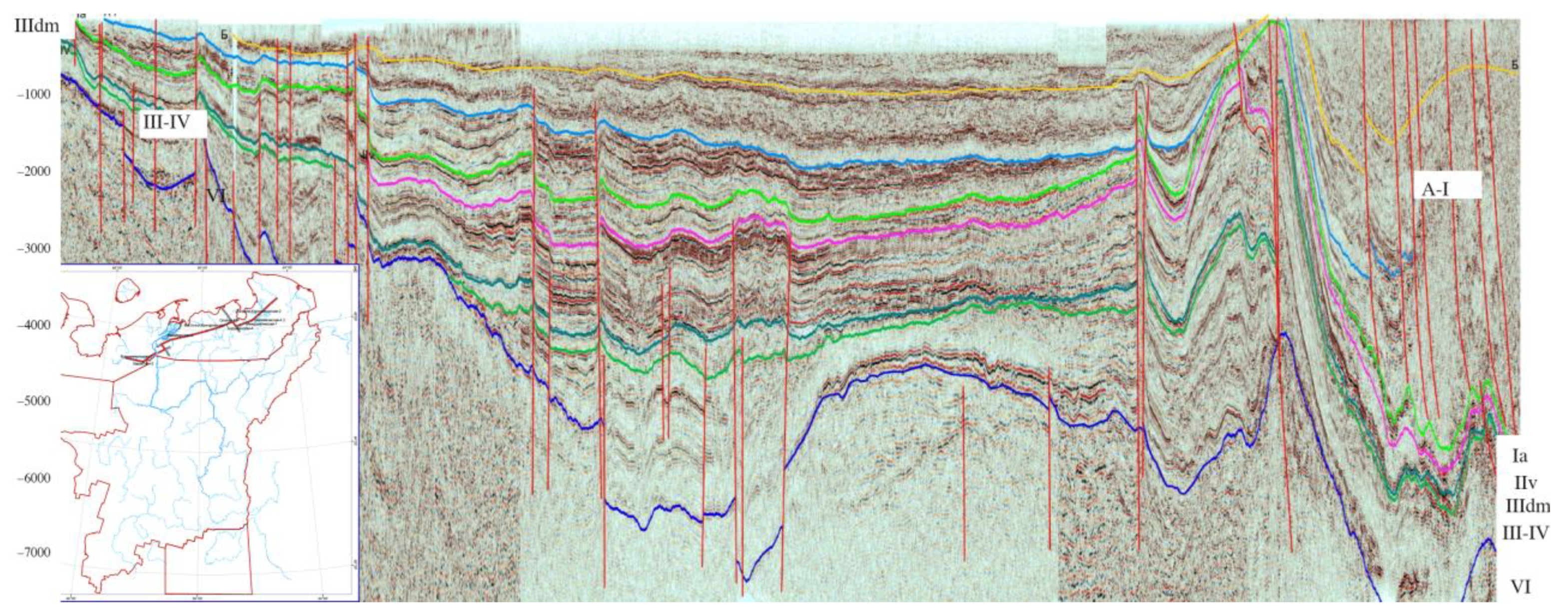
As a result of our work, the sedimentary cover in this region has been subdivided into several seismo-stratigraphic complexes identified both onshore and offshore on the structural map constructed for the reflecting horizons (RH), such as VI (basement surface) (
Figure 9), V-V1 (Silurian sole), IV (Silurian roof), III-IV (Silurian surface of different ages—Lower Devonian), III2 (Middle Devonian horizon), IIId (sole of Domanik—Middle Frasnian, Upper Devonian), IIIfm1 (Lower Famenian), IIv (Visean Carboniferous roof horizon), Ia (Lower Permian carboniferous surface), A-I (Lower Triassic roof), and B (horizon in Jurassic sediments) (
Figure 10).
The seismo-geological model thus obtained was used to refine the tectonic and oil and gas zoning of the North of the Timan-Pechora province, including the Pechora Sea.
As a result, we have improved the locations of the boundaries of the main tectonic elements (top-order structures), such as north of the Izhma-Pechora syneclise, the Malozemelsk-Kolguev monocline, north of the Pechora-Kolvinskoe aulacogen, the Horeyversko-Pechora sea basin, the North-Pechora sea monocline, the pre-Paikhoisk-pre-Yuzhnovozemelsky depression (see
Figure 10 and
Figure 11) deflection, and the Gulyaevsko-Varandeyskay structural-tectonic zone. These improvements relate mostly to the offshore part of the study area, and they have allowed us to establish the hierarchy of the refined boundaries based on their relationship.
There is a discrepancy between the structural plans of the sedimentary cover surface and the surface of Permian carbonates (
Figure 9), which determines significant differences in oil and gas content controlling factors on different structural floors. A broad presence of basal deposits of the early-middle Ordovician age, probably terrigenous, has been discovered in the western part of the sedimentary basin.
Contrary to this, at the base of the sedimentary cover in the Pechora-Kolvinskoe aulacogen (rift) and Varandey-Adzvinsky structural zone, development-sustained carbonate deposits (platform carbonates) with high oil-generating potential have been identified, thus determining the prospects of the continuation of the Timan-Pechora province to the Arctic shelf.
Our research has substantially improved understanding of the structure and volume of pre-inversion (riftogenic) sediments for the following structures: (1) the outer part of the Pechora-Kolvinskoe aulacogen and its marine continuation (age O2–3, S1–2, D1–2), (2) uncompensated troughs developed along the Timan ridge and the Kanin uplift and filled with terrigenous sediments (age Ꞓ, O1–2), and (3) a trough that bounds the sedimentary basin in the north and that was filled with relatively deep-water sediments of domanik type (age D3–C1t) in the late Devonian-early Carboniferous time. As a result, the evaluation of the oil and gas potential of the whole region has been significantly modified.
Quantitative assessment of oil and gas potential is based on geological understanding of sedimentary basin evolution, source rock characterization, oil and gas-bearing strata in these basins, as well as regional, zonal and local characteristics of the region that enable a reasonable forecast and refinement of already identified hydrocarbon potential. The most significant confirmation of the prospects comes from already booked reserves of the identified fields based on drilling and, indirectly, on seismic data.
A series of studies targeting improved assessment of the oil and gas potential (“quantitative assessment of oil and gas resources”) of Russian regions (as of 01/01/2017) has been completed. This assessment, carried out by VNIGNI, VNIIOkeangeologiya, and VNIGRI [
48], covers all prospective oil and gas-bearing basins, including the Western Arctic regions of Russia.
Private oil and gas companies operating onshore, and two companies that are part-owned by the State (Gazprom and Rosneft) and have exclusive rights to work on the Arctic shelf, conduct their internal assessments of the hydrocarbon potential. However, their estimates often relate exclusively to areas of existing licenses or prospective licensing areas that companies consider to be priorities for development.
Preliminary results of the official quantitative assessment of the resources of the Arctic, offshore and onshore, have already been published [
7,
21,
34,
42,
47,
49,
50,
51,
52], and in this paper, they are presented to characterize the oil and gas potential of the sedimentary basins under consideration [
11,
28,
40,
41,
43].
The quantitative assessment of resources of poorly studied and complex areas of the Arctic [
17,
44,
45,
46] is a result of research by geologists who were able to build a system of concepts about the geological evolution of these areas on a basis of fragmentary regional geological and geophysical data, and to construct models of geological structure of sedimentary basins that define hydrocarbon potential [
53].
6. Discussion: Assessment of the Resources of the Western Arctic Shelf
By any measure, the petroleum potential of the Russian sector of the Western Arctic is unique, both in terms of the volume and diversity of its composition, as proved by discoveries of unique, giant, and large oil and gas fields onshore. More than 50 giant and large fields have been identified in this territory. To develop projects in the Western Arctic and to exclude purely market-related factors, it is necessary to carry out special research aimed at obtaining new geological and geophysical information for a more objective assessment of petroleum potential, and to take into consideration the experience of international and Russian experts.
The best-known estimates were made by the consulting companies Wood Mackenzie and Fugro Robertson in 2006 [
54], and USGS—United States Geological Survey in 2008 [
55], which conducted two special studies of the hydrocarbon potential of the Arctic.
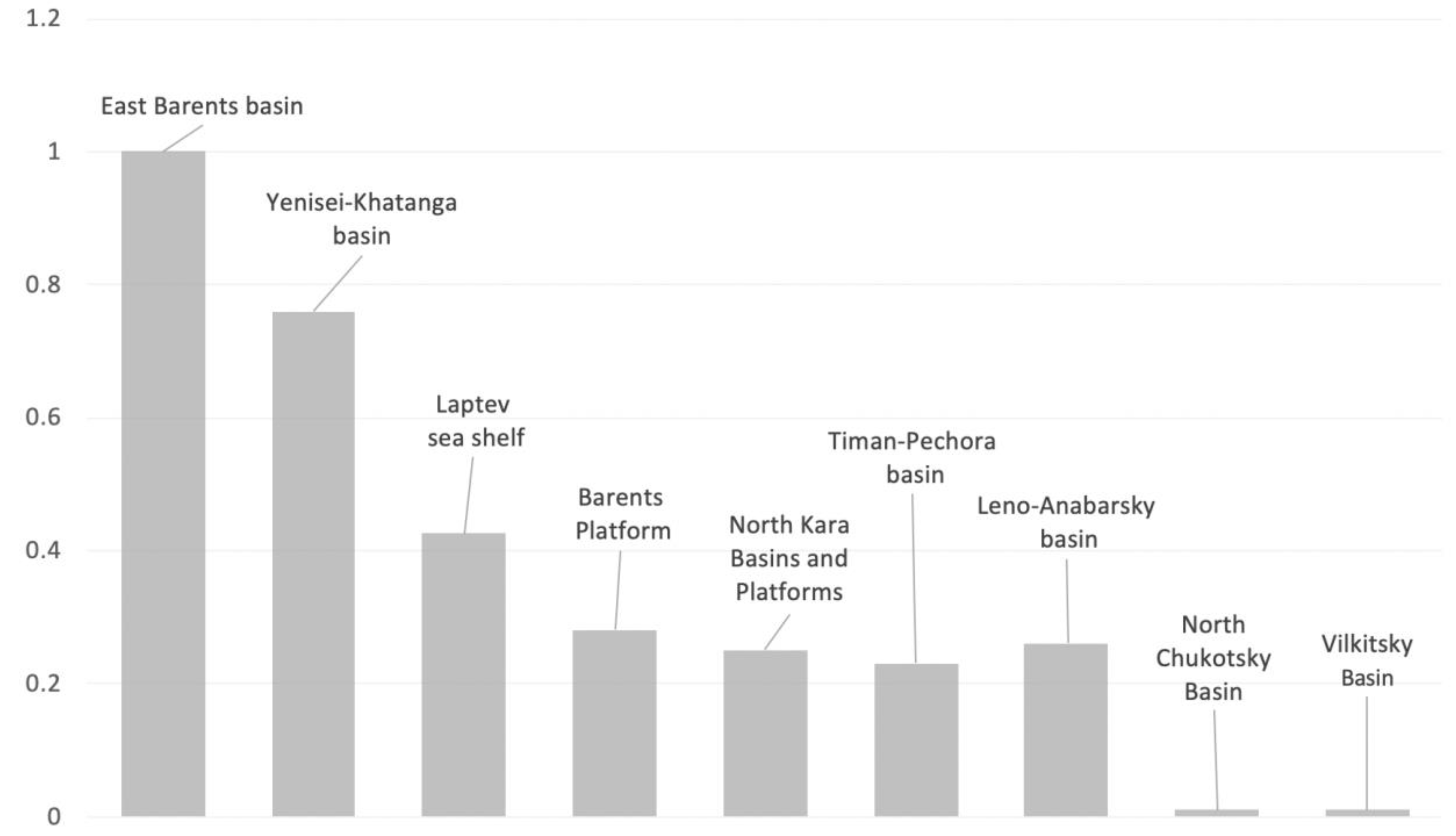
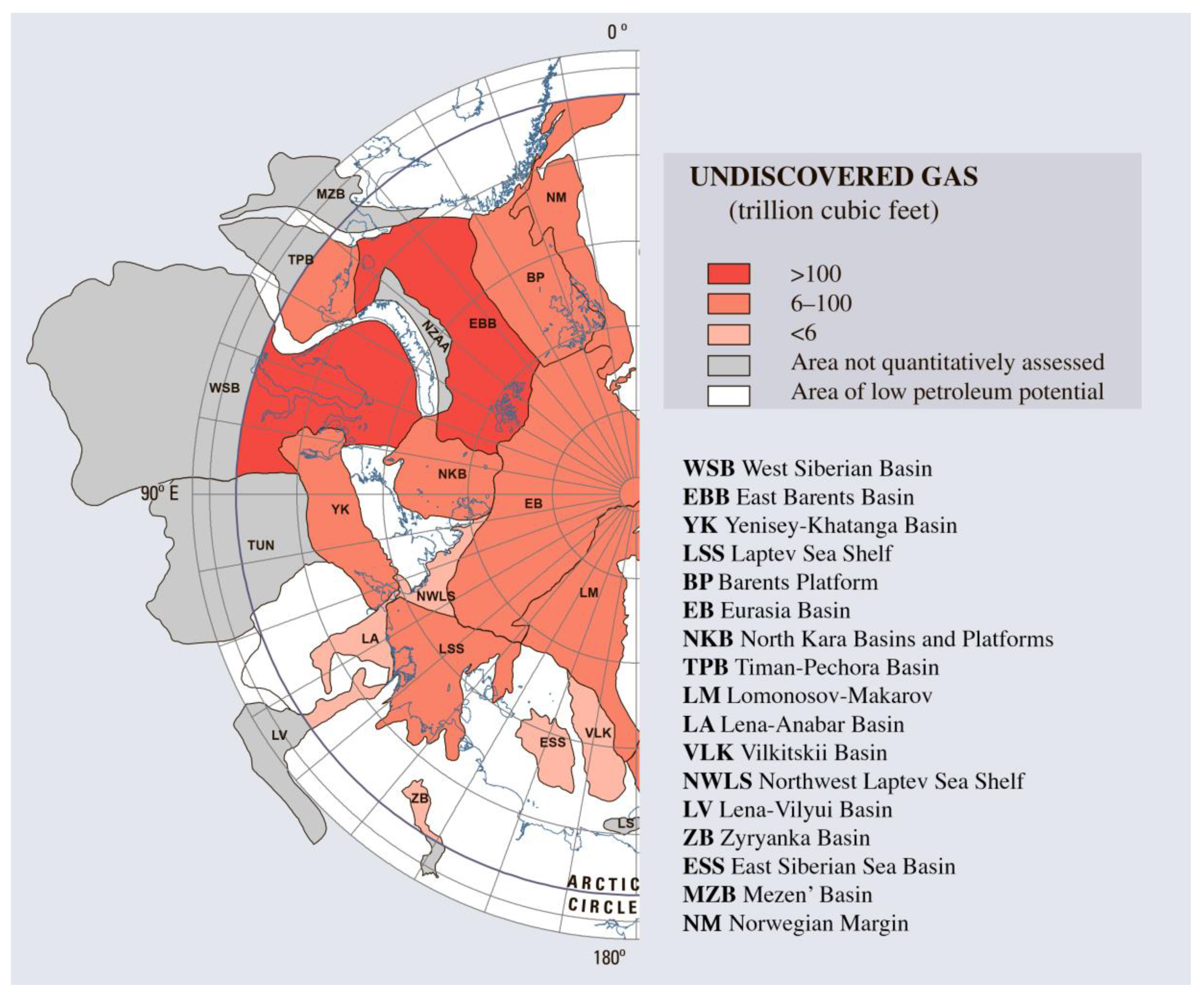
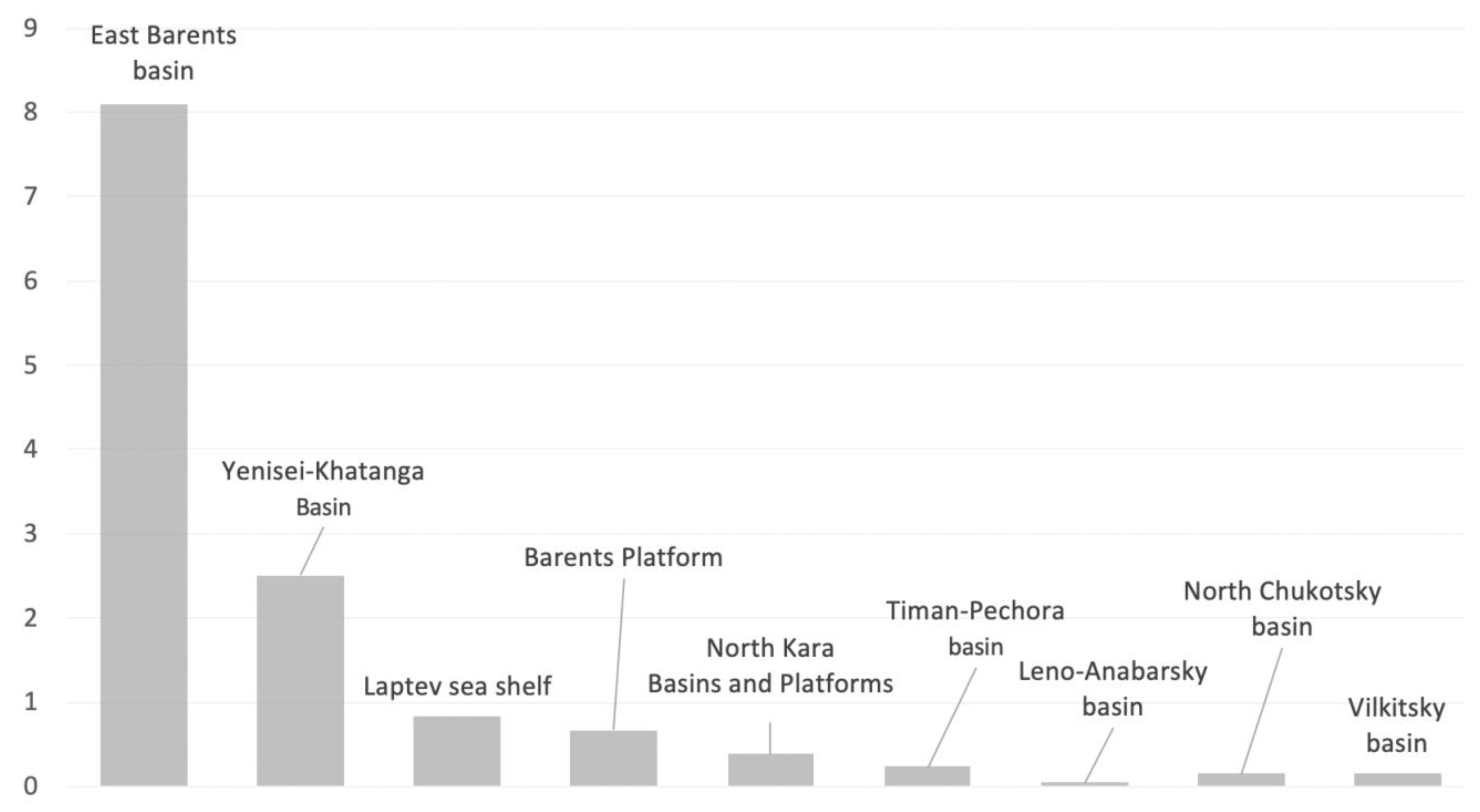
USGS has analyzed 25 out of 33 Arctic basins, including two primarily onshore areas of the Western Arctic—the northern part of the Timan-Pechora Basin and the northern part of the West Siberian Basin and three offshore areas of the Northern (Norwegian) Barents and Kara seas: (1) the East Barents Sea, (2) Barents Platform, (3) and North Kara Basins and Platforms (
Figure 12,
Figure 13 and
Figure 14). The deep-water Eurasian basin limits the basins of the Western Arctic from the north in these studies.
Different approaches were used in [
54] and [
56]. For the purposes of our analysis, we have converted petroleum potential estimates of [
54] and [
56] originally presented in barrels for oil/oil equivalent (o.e.) and in cubic feet for gas to, more commonly used in Russia, tons and cubic meters, respectively. We have used the following conversion coefficients: 1 barrel of oil = 0.14 metric tons of oil [
57]; 1 barrel of oil equivalent = 0.1462 tons of oil equivalent [
58]; 1 billion cubic feet of natural gas = 25,199.58 tons of oil equivalent [
58].
The Wood Mackenzie and Fugro Robertson report [
54] is based on a detailed analysis of geophysical and seismic data in various Arctic basins. According to this study, the undiscovered oil and gas resources of the Arctic are estimated at 233 billion barrels of oil equivalent (o.e.), or more than 30 billion tons o.e. A total of 85% of the proven reserves and 74% of the expected reserves (resources) are gas.
In the USGS study [
56], the main emphasis was on probabilistic geological analysis and the identification of zones that are likely to contain relatively large oil or gas reserves (more than 50 million tons).
The total volume of undiscovered oil and gas resources in the entire North of the Arctic Circle region is ~412 billion barrels of o.e., or ~22% of the total undiscovered reserves of conventional hydrocarbons in the world. This is almost double the Wood Mackenzie/Fugro Robertson estimate [
54].
Undiscovered oil resources were estimated at ~90 billion barrels of oil, or 12.3 billion tons at 0.862 t/m3 conversion density. That amounts to ~7% of the world’s resources.
Undiscovered gas resources were estimated at ~1669 trillion cubic feet of gas (~47.2 trillion m3) and 44 billion barrels of natural gas condensate (or 5.5 billion tons (at 0.780 t/m3 conversion density).
The total estimate of the Arctic hydrocarbon resources according to [
54] was ~65 billion tons of o.e.
At the same time, the share of comventional oil, including liquid fractions of natural gas (NGL), in the USGS study [
56] accounted for about 134 billion barrelss (or 17.8 billion tons of o.e.). That is 13–15% of the world’s total resources [
55]. Conventional natural gas accounts for the remaining ~279 billion barrels of o.e., or just under 30% of the world total gas resources.
It is important to note that about 80% of the Arctic resources are confined to a relatively shallow shelf (less than 500 m water depth). Moreover, USGS estimates that the probability of finding any significant hydrocarbon reserves in the Central Arctic ocean, as well as in the surrounding areas, is close to zero.
According to our analysis of USGS data (see Table 1 in [
55]), Russia accounts for approximately 70% of the total undiscovered gas resources in the Arctic, with the main prospective areas located in the north of the West Siberian basin including the southern part of the Kara Sea, with estimated resources of 18.5 trillion m
3, and East Barents Sea (9.0 trillion m
3).
According to [
56], Russia has ~30 billion barrels of o.e. (estimates for all Arctic basins of the Russian Federation), or 33% of the total Arctic oil resources, with 7.4 billion barrels of o.e. localized in the southeastern part of the Barents Sea. A total of 3.7 billion barrels of o.e. are expected in the West Siberian Basin, 2.0 and 1.8 billion barrels of o.e. in the deep-water part of the Barents and Kara seas, and 1.6 billion barrels of o.e. in the Timan-Pechora Basin.
The share of liquid hydrocarbons in the Western Sector of the Russian Arctic increases up to 41% of the total resources of the entire Arctic if 3.7 billion tons of natural gas liquid (NGL) resources are added.
Thus, the total technically recoverable resources of the Russian Arctic sector are estimated by USGS at about 40 billion tons o.e., of which only 4.3 billion tons are oil, more than 32 trillion m3—gas, and about 3.7 billion tons o.e.—condensate.
A more modest estimate of hydrocarbon resources of the Russian Arctic (76.3 billion tons of o.e) was presented by the World Energy Agency (WEA) [
59,
60]. According to the WEA, the recoverable part of crude oil resources in the Russian sector does not exceed 9.6 billion tons of o.e., and gas resources are estimated at a modest 21.4 trillion m
3. Thus, the total estimate of recoverable resources for the Russian Arctic without condensate is only 31 billion tons of o.e. [
40].
The same study shows that a total of 61 major oil and gas fields have already been discovered north of the Arctic circle, with 43 of them in Russia (today there are more than 50 of them according to our data), 11 in Canada, 6 in Alaska, and 1 in Norway, which also indicates the dominance of the Western Arctic in the structure of existing discoveries.
According to UN estimates [
61,
62], oil resources of the entire Arctic are estimated at 140–180 billion tons, of which almost 40% are in the Eastern part of the region, and about a third are located between the North Pole and the American continent. Thus, according to the UN estimate, the potential of the Western Arctic is 40–45 billion tons of o.e. UN experts stated that, given the huge technical difficulties in the development of these resources, the economic feasibility of Arctic projects is highly questionable [
3].
There are serious concerns that the official resource assessment [
40,
41,
63] may be biased due to over-reliance on the official point of view about the huge potential of the Arctic [
40]. This conclusion is based on the fact that estimates of the petroleum potential of the least explored parts of the Arctic shelf in the last 20 years show a steady increase, regardless of the increase in the knowledge database, the number of new important discoveries, or the development of fundamentally new ways of increasing the hydrocarbon resource base. Additionally, it is not possible to obtain new core material for geochemical studies that could improve estimates of the petroleum potential and could indicate its underestimation.
For example, the total hydrocarbon resources of the richest Western Arctic shelf, according to the official estimate as of 01/01/1993, were at 75.3 billion tons of oil equivalent [
21,
34]. The next estimate (as of 01/01/2002) showed an increase of 7.26 billion tons of oil equivalent, comprising 0.26 billion tons of oil equivalent increase for the Pechora Sea, 1.9 billion tons of oil equivalent increase for the Barents Sea, and 5.1 billion tons of oil equivalent increase for the Kara Sea. The estimate as of 01/01/2009 showed a further increase in resources (17.5 billion tons of oil equivalent), resulting in the total evaluation of oil and gas resources of the offshore Western Arctic region at more than 100 billion tons of oil equivalent.
The last, recently completed, 2020 assessment consolidated the volume of hydrocarbon resources of the Western Arctic basins at 101 billion tons of oil equivalent, including 55.3 in the Barents Sea and 45.7 in the Kara Sea [
64,
65].
The above-mentioned increase in resource estimates is paradoxical: we observe a significant decrease in the ratio of drilled and proven reserves to the overall assessment of the petroleum potential of the region against the background of a significant increase in geophysical, including seismic, studies [
66].
Such conclusions are especially paradoxical in the Pechora Sea area, where the latest identification of the new deposits goes back to 1993–2002, but a significant resource estimate increase occurs at a time when there were no discoveries (2002–2009). Such inconsistencies make us more careful and reserved about the assessment of resources at the present time.
Completed quantitative assessment of oil and gas resources is based on modern ideas about the tectonic structure of sedimentary basins of the Western Sector of the Russian Arctic, as well as on the new data about the volume of sediments and source rock potential, and also on comparative analysis on existing discoveries (the method of geological analogy). This assessment indicates a greater potential for both oil and gas.
The volume of forecast hydrocarbon resources (oil, free gas, condensate, and dissolved gas) of the Russian Arctic is estimated at 250 billion tons of oil equivalent, including ~43 billion tons of oil and condensate (17% of all resources) and ~206 trillion m
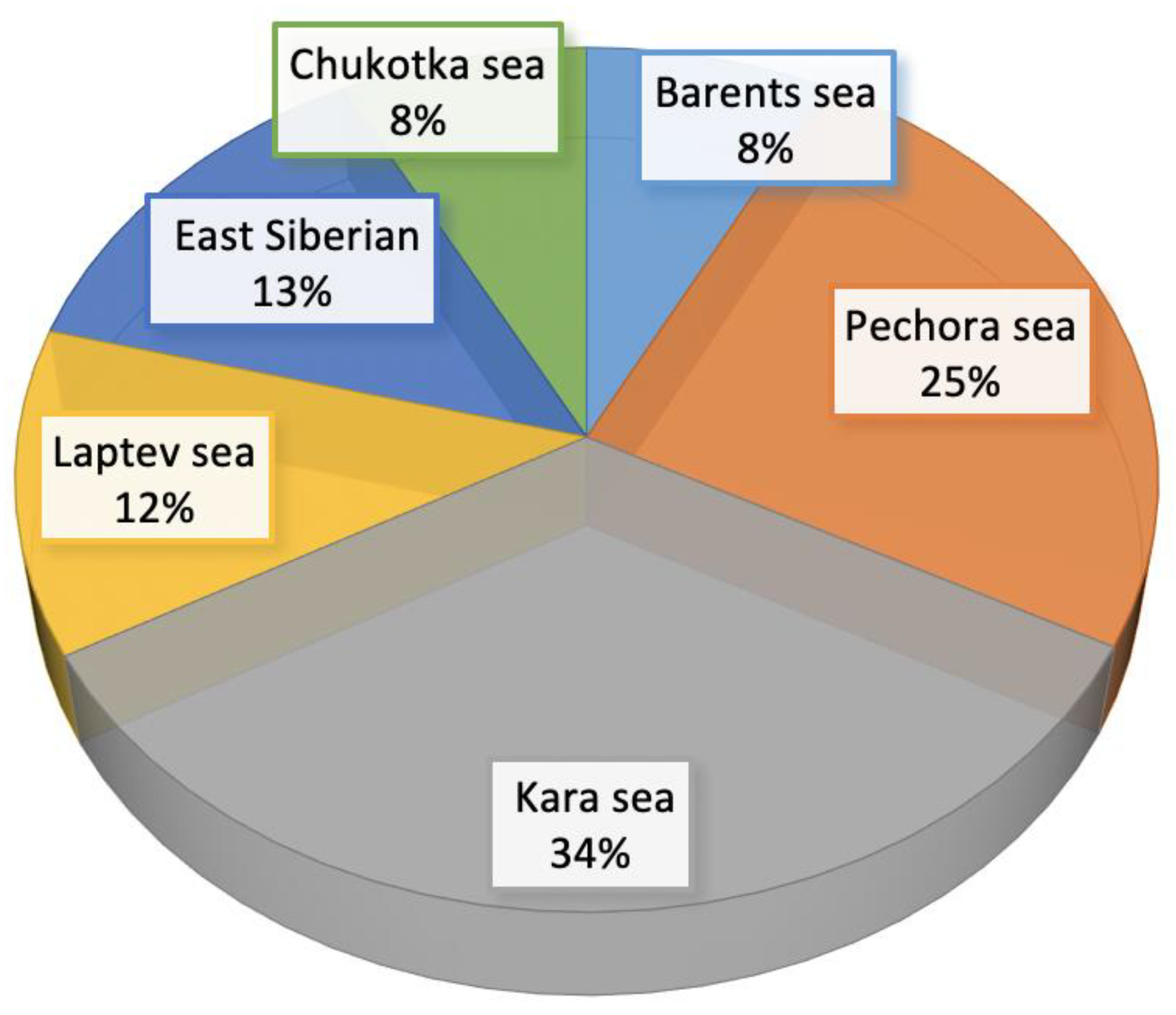
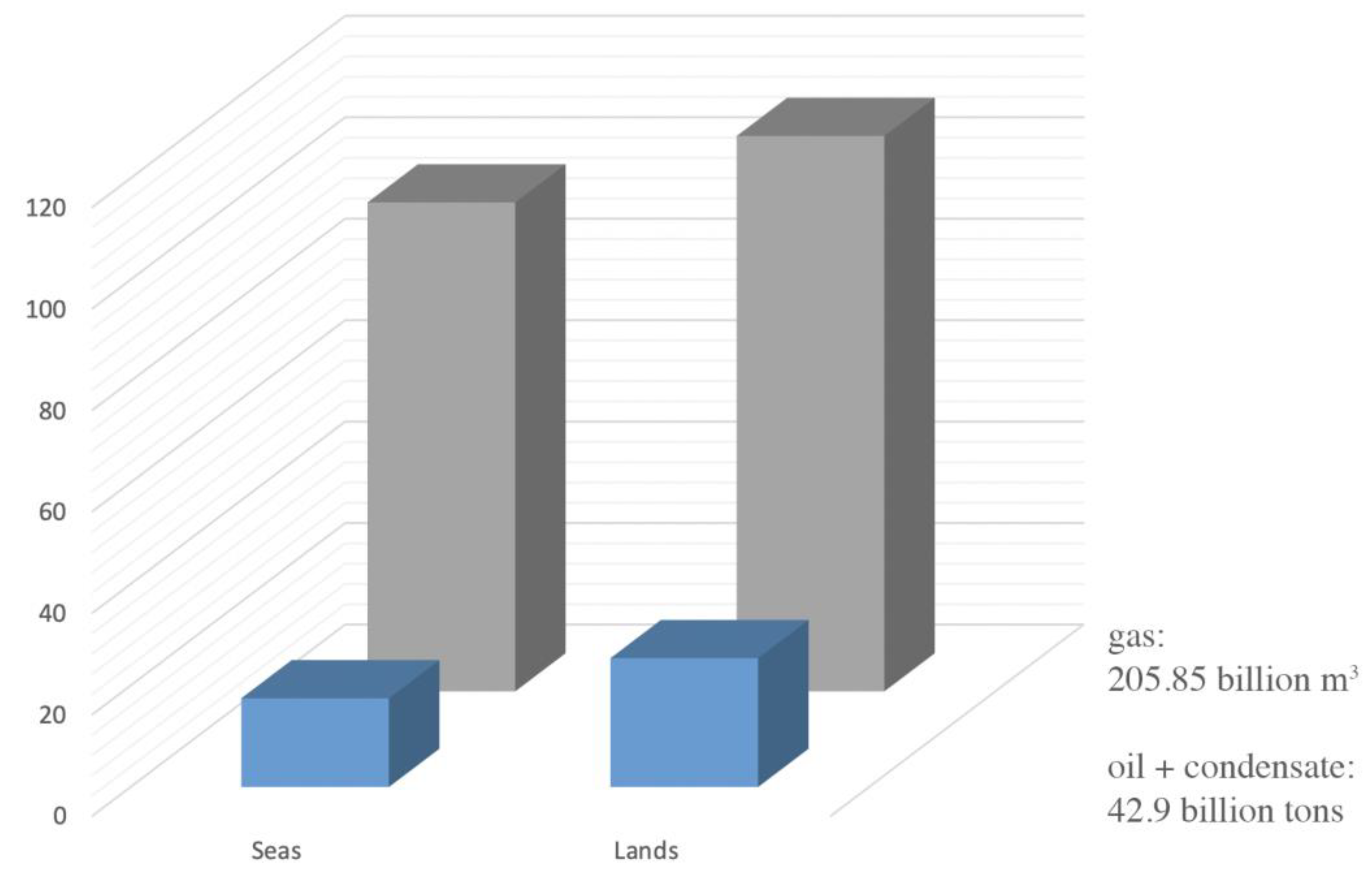
3 of natural gas. The distribution of hydrocarbon resources within the prospective regions onshore and offshore the Russian Arctic is very uneven (
Figure 15,
Figure 16 and
Figure 17). The onshore accounts for ~136 billion tons of oil equivalent (almost 55% of the total amount), of which the vast majority are gas-containing fields located administratively in the Yamal-Nenets Autonomous district (120 billion tons of oil equivalent, including 97 trillion m
3 of gas). The remaining 45% is also mostly gas dispersed within the Arctic shelf.
The total potential of the Western Arctic of the Russian Federation is estimated by us at 13.4 billion tons of liquid hydrocarbons (oil and gas condensate) and 86.7 trillion m3 of gas.
Most of the liquid hydrocarbons are predicted in the shallow water extension of the Timan-Pechora and West Siberian sedimentary basins (the Pechora Sea—5.5 billion tons, the southern part of the Kara Sea—2.0 billion tons).
The estimated potential of the northern part of the Timan-Pechora basin onshore exceeds 5.5 billion tons of o.e. This estimate reflects the most up-to-date level of geological and geophysical studies and exploration. More than 2.0 billion tons o.e. of recoverable oil and gas reserves are in the identified fields, including producing fields [
40].
International resource assessments heavily emphasize technological resource availability and the economic feasibility of exploration and development. Taking this into account, resources of shallow water continuations of the Timan-Pechora and West Siberian oil and gas provinces are estimated highly enough.
In summary, estimates of poorly explored sedimentary basins of the Arctic shelf remain controversial, both in terms of overall potential and phase composition ratio.
Some debate was caused by the assessment of the petroleum potential of the offshore continuation of the West Siberian province. According to a group of researchers, the main undiscovered gas resources of the Arctic zone [
67] of this province are concentrated in the Aptian, Neocomian, and middle Jurassic, including the Kara Sea, and they can reach 33–43 trillion m
3.
The following discoveries are predicted: (1) 3 to 4 supergiant (more than 1 trillion m3) fields in the open shelf area, (2) 22 to 25 largest and giant (0.1–1.0 trillion m3) fields, (3) 70 to 80 large (30–100 billion m3) fields, and (4) several hundreds of medium and small fields.
7. Conclusions
The tectonic development of the Western Arctic determined the formation of sedimentary basins characterized by high oil and gas potential.
The accumulation of oil and gas source rocks and the formation of reservoirs occurred mostly at initial divergent stages of basin evolution. In the Timan-Pechora basin, this happened in Silurian-Tournaisian.
Formations of convergent stages in most cases contain only natural gas reservoirs.
Some source rock formations in the Timan-Pechora basin have entered or passed through the oil and gas generation windows, which resulted in a significant scale of hydrocarbon generation and migration.
The position of oil and gas generation windows within various accumulation zones in the main oil and gas complex, in general, favorably coincided with stages of their formation and led to the large-scale formation of palaeo-zones of oil and gas accumulation.
The generation of hydrocarbons in the Timan-Pechora basin, including its northern part (Pechora Sea), was completed at the end of Triassic, but its structural evolution and subsidence extended post-Triasic.
Three genetic types of free gas accumulations are distinguished in the Timan-Pechora basin: (1) gas sourced from Permian-Triassic mixed organic matter of the waters; (2) gas of modern active uplift zones at relatively shallow depths that can be genetically associated with any catagenesis zone; (3) gas formed at favorable conditions of the final catagenesis and apo-catagenesis stages that is mostly associated with depressions.
Estimates of the petroleum potential of the Western Arctic vary broadly—from 34.7 to more than 100 billion tons of oil equivalent, with the share of liquid hydrocarbons from 5.3 to 13.4 billion tons of oil equivalent, and the condensate share from 8.0 to 13.4 billion tons of oil equivalent.
Gas dominates in the Western Arctic, with oil accumulation zones restricted to the offshore part of the Timan-Pechora basin, and condensate accumulation zones to the offshore part of the West Siberian basin on the Kara Sea shelf.
Large discrepancies in the assessment of discovery structure and in the petroleum potential estimates reflect the uncertainty of experts, probably caused by a lack of experience in work with an extremely low knowledge base.


 ,
, 