The Value of Marine Spatial Open Data Infrastructures—Potentials of IHO S-100 Standard tο Become the Universal Marine Data Model


Abstract
1. Introduction
1.1. Marine Activity Domains
1.1.1. Managing Human Activities at Coastal Areas and Sea
- integrated and multi-objective, including all important economic sectors; economic and social objectives as well as ecological ones,
- strategic and future-oriented, considering alternative means to achieve a vision,
- continuing and adaptive, with an emphasis on performance monitoring and learning by doing,
- participatory, building a broad base of stakeholders to ensure long-term support for management,
- ecosystem-based, with a focus on maintaining ecosystem services over time,
- place-based, with a focus on marine spaces that people can understand, relate to, and care for.
1.1.2. Protection of the Marine Environment
1.1.3. Maritime Transport
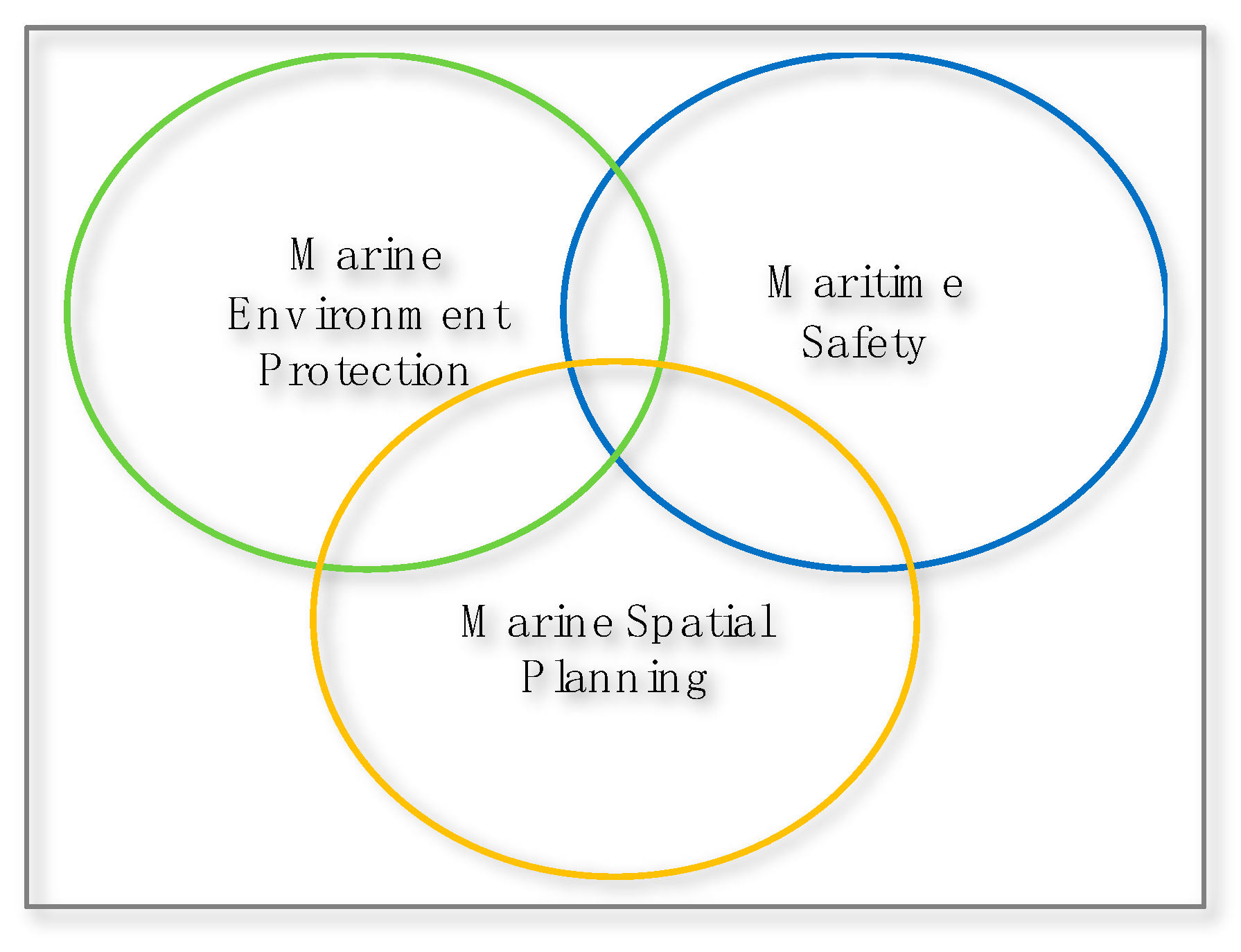
1.2. Marine Information Domains
Need for the Best Available Data
1.3. Paper Objectives
1.4. Methodology
- determination of the marine information domains (maritime safety, marine environment, marine spatial planning)
- identification of the international organizations involved (Open Geospatial Consortium—OGC, World Wide Web Consortium—W3C, International Hydrographic Organization—IHO, European Union—EU associations)
- monitoring the activities of relevant working groups
- extensive review of the working groups’ reports
- identification of challenges and limitations
- determination of assessment criteria from the common challenges or limitations for two comparative analysis (open data platforms—ODP and marine spatial data models—MSDM standards)
- functional review of national organizations use cases that have implemented ODP technologies
- design of comparative matrices
- population of the comparative matrices with data from the conducted assessment
- extraction of results and conclusions
2. Open Data Potential
2.1. Economic Value of Open Data
- Public sector information is information generated, created, collected, processed, preserved, maintained, disseminated or funded by or for the Government or public institutions.
- Private sector information is the data collected, produced and owned by either private natural or legal entities.
- Open data refer to data that is open in terms of: access, redistribution, reuse, absence of technological restriction, attribution, integrity and no discrimination.
- Open government data are data produced or commissioned by public bodies or government controlled entities that are made accessible, can be freely used, reused and redistributed by anyone.
- Open private data, as in the context of open government data, the license will specify their terms of use.
2.1.1. Open Data Value Chain
2.1.2. From Data to Information and Knowledge
- Raw data, that corresponds to quantities or other quantitative or qualitative attributes derived from observation, experiment, measurement or computation. The data are not structured, contextualized nor commented.
- Information that corresponds to a set of contextualized and structured data, the producer’s intention being to make them meaningful.
- Knowledge corresponds to the cognitive appropriation of the information by an individual who organizes, synthesizes or summarizes it to make it more readily understandable.
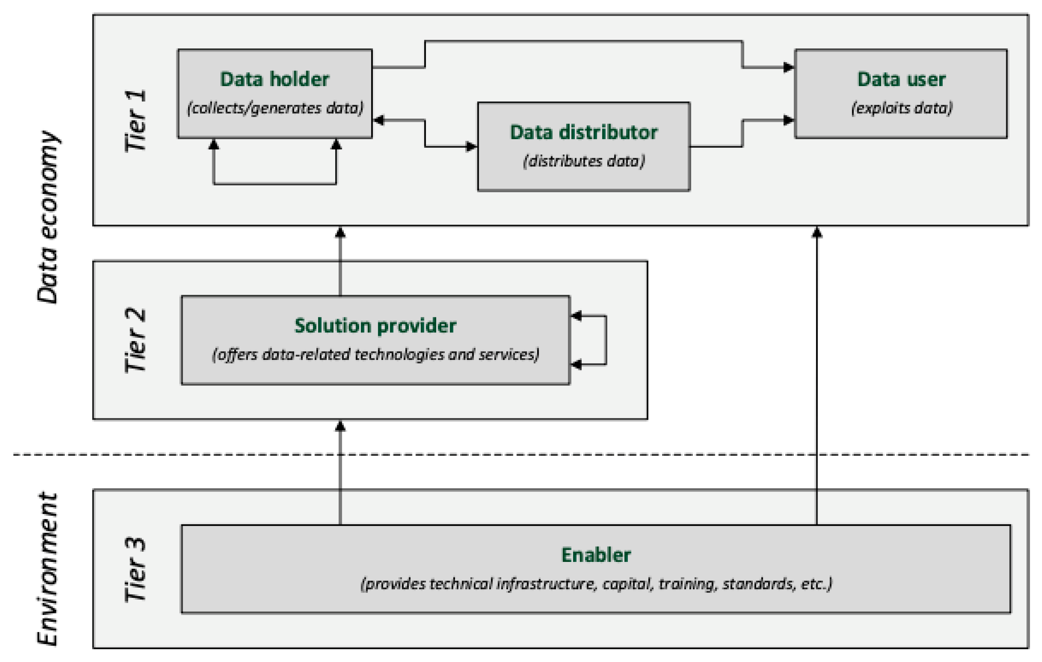
2.1.3. Data Economy Population
2.2. Open Data Directive
2.2.1. High-Value Datasets
- geospatial
- earth observation and environment
- meteorological
- statistics
- companies and company ownership
- mobility
2.2.2. Publishing Principles
2.2.3. Publicly-Funded Research Data
2.3. Publishing Open Data
- make it available on the web (whatever format) but with an open license
- make it available as machine-readable structured data
- as (2) plus non-proprietary format (e.g., CSV instead of excel)
- all the above, plus use semantic standards (RDF and SPARQL) to identify things, so that people can point at your data
- all the above, plus link your data to other people’s data to provide context
2.3.1. Open Data Principles
2.3.2. Open Data Licensing
- Creative Commons: CC-By and CC0 (Public Domain Dedication)
- Open Database License/Open Data Commons Open Database License (ODbL)
- Open Data Commons Public Domain Dedication and License (PDDL)
3. Spatial Data on the Web
3.1. Data on the Web Best Practices
3.1.1. Linked Open Data
3.1.2. Linked Closed Data
3.2. Spatial Data on the Web Best Practices
- use globally unique persistent HTTP URIs for spatial things
- make your spatial data indexable by search engines
- link resources together to create the Web of data
- use spatial data encodings that match your target audience
- provide geometries on the Web in a usable way
- provide geometries at the right level of accuracy, precision and size
- choose coordinate reference systems to suit your user’s applications
- state how coordinate values are encoded
- describe relative positioning
- use appropriate relation types to link spatial things
- provide information on the changing nature of spatial things
- expose spatial data through “convenience APIs”
- include spatial metadata in dataset metadata
- describe the positional accuracy of spatial data
3.3. Spatial Data Infrastructures
3.3.1. SDIs to the Web
- Best practice 1: Use globally unique persistent HTTP URIs for spatial things
- Best practice 2: Make spatial data indexable by search engines
- Best practice 3: Link resources together to create the Web of data
- Best practice 12: Expose spatial data through “convenience APIs”
3.3.2. SDI Architecture
3.4. OGC API for Spatial Data
- the web map service (WMS), that enables sharing of images
- the web feature service (WFS), that enables sharing of feature data with attributes
- the web coverage service (WCS), that enables sharing of raster data
- the web processing service (WPS), that enables sharing of algorithms to perform on data (for example coded in Python)
4. Open Data Platforms (ODP)
4.1. ODP Types
- -
- Directory: is a catalogue of data sets that includes services for searching, metadata, clear licensing information and access to the data sets themselves.
- -
- Platform: provides an online entrance for users to access available datasets to a geospatial data infrastructure. A platform includes the data directory along with other information and services that are part of the open data ecosystem. Data platform services are often implemented with a range of open data technologies.
- -
- Portal: is a website that serves as a cyber door to the Internet in a particular area of interest or industry. A web portal usually provides specialized content, search engine capabilities and links to other relevant websites.
4.2. ODP Features
- easy access
- search capabilities
- access to machine-readable data
- metadata
- reporting of data licenses
- preview/display data
- compliance with standards
- application programming interface (API)
- security
4.3. Selecting and Implementing an ODP
- -
- there should be only one single entry providing a clear overview of all data and download options available,
- -
- data should be regularly updated in order to improve the usability of the data,
- -
- metadata should be provided for the quality and resolution of the data,
- -
- a clear strategy on how the data are published and updated,
- -
- functionality to search for data based on resolution and time of origin,
- -
- web services to allow viewing the data in users’ own applications, improving interoperability,
- -
- international, open technical standards should be used, ensuring interoperability between platforms in different countries,
- -
- if any overlap between data in different portals exist, they are to be clearly communicated to the users,
- -
- easy-to-read guides should be provided for how to use the portals.
5. Marine Spatial Data and Data Models
5.1. Marine Spatial Data
- hydrographic data
- oceanographic data
- land and coast data
- vessel tracking data
- port information and data
- meteorology and climate data
- cryosphere data
- marine historical data
- real-time sensor data
- crowd-sourced data
5.2. Marine Data Models
5.2.1. The IHO Transfer Standard for Digital Hydrographic Data—S-57
5.2.2. The IHO Universal Hydrographic Data Model—S-100
S-100 Geospatial Information Registry
- -
- Feature concepts used to build feature catalogues
- -
- Portrayal information
- -
- Producers codes
- -
- Product specifications
S-100 Based Product Specifications
- International Hydrographic Organization (IHO): numbers S-101 to S-199.
- International Association of Light Authorities (IALA): numbers S-201 to S-299.
- Intergovernmental Oceanographic Commission (IOC): numbers S-301 to S-399.
- Joint Technical Commission for Oceanography and Marine Meteorology (WMO/IOC JCOMM): numbers S-411 to S412.
- International Electrotechnical Commission - Technical Committee 80 (IEC-TC80): numbers S-421 to S-430.
5.2.3. The EU INSPIRE Directive and Data Model
- Ocean geographic features (OF)
- -
- Remote-sensing of sea surface temperature, dynamic topography, synthetic aperture radar winds and ocean color
- -
- Drifting buoys provide surface velocity, temperature and atmospheric pressure
- -
- Ships-of-opportunity and regular voluntary observing ships provide temperature (bathythermograph) profiles
- -
- Argo floats provide temperature and salinity profiles
- Sea regions (SR)
- Atmospheric conditions and meteorological geographical (AC)
- Elevation (EL)
6. Marine Data Models Comparative Analysis
6.1. Marine Data Models Capabilities
6.2. Marine Data Models Capabilities Matrix
6.3. Marine Data Models Relation to Information Domains
7. Marine Spatial Data Infrastructure (MSDI)
7.1. MSDI Purpose
MSDI Stakeholders
7.2. MSDI Governance
8. Discussion
- Sustainable management
- Ecosystem approach
- Long term perspective and objectives
- Precautionary principle
- Participation and transparency
- High quality data and information basis
- Transnational coordination and consultation
- Coherent terrestrial and maritime spatial planning
- Planning adapted to the characteristics and special conditions in different areas
- Continuous planning
9. Conclusions
Author Contributions
Funding
Conflicts of Interest
References
- The Ocean: Earth’s Life Support. Available online: https://www.dw.com/en/the-ocean-earths-life-support/g-50260791 (accessed on 11 January 2020).
- Ehler, C.N. Marine spatial planning. In Offshore Energy and Marine Spatial Planning; Routledge: Abingdon, UK, 2018; pp. 6–17. [Google Scholar] [CrossRef]
- Bradshaw, C.J.A.; Greenhill, L.; Yates, K.L. The future of marine spatial planning. In Offshore Energy and Marine Spatial Planning; Routledge: Abingdon, UK, 2018; pp. 284–293. [Google Scholar] [CrossRef]
- Pelagic Zones. Available online: https://www.britannica.com/science/pelagic-zone (accessed on 12 January 2020).
- Crowder, L.; Norse, E. Essential ecological insights for marine ecosystem-based management and marine spatial planning. Mar. Policy 2008, 32, 772–778. [Google Scholar] [CrossRef]
- Ehler, C.; Douvere, F. Marine Spatial Planning: A Step-by-Step Approach; UNESCO: Paris, France, 2009; 99p. [Google Scholar] [CrossRef]
- Shipping and World Trade. Available online: https://www.ics-shipping.org/shipping-facts/shipping-and-world-trade (accessed on 20 June 2020).
- Maritime Safety. Available online: http://www.imo.org/en/OurWork/Safety/Pages/Default.aspx (accessed on 20 June 2020).
- European Commission. Marine Knowledge 2020, from Seabed Mapping to Ocean Forecasting; Green Paper COM (2012) 473; Directorate-General for Maritime Affairs and Fisheries: Brussels, Belgium, 2012. [Google Scholar]
- McKinsey Global Institute. Open Data, Unlocking Innovation and Performance with Liquid Information. 2013. Available online: https://www.mckinsey.com/~/media/McKinsey/Business%20Functions/McKinsey%20Digital/Our%20Insights/Open%20data%20Unlocking%20innovation%20and%20performance%20with%20liquid%20information/MGI_Open_data_FullReport_Oct2013.ashx (accessed on 2 May 2020).
- Berends, J.; Carrara, W.; Radu, C. EDP—Analytical Report 9: The Economic Benefits of Open Data. 2017. Available online: https://www.europeandataportal.eu/sites/default/files/analytical_report_n9_economic_benefits_of_open_data.pdf (accessed on 2 May 2020).
- Big Data Isn’t a Concept—It’s a Problem to Solve. Available online: https://datascience.berkeley.edu/blog/what-is-big-data/ (accessed on 1 February 2020).
- European Union. Creating Value through Open Data: Study on the Impact of Re-use of Public Data Resources; European Data Portal; European Union: Brussels, Belgium, 2015. [Google Scholar] [CrossRef]
- International Hydrographic Organisation (IHO). Spatial Data Infrastructures “The Marine Dimension”. Guidance for Hydrographic Offices; IHO Publication C-17—Edition 2.0.0; International Hydrographic Bureau: Monaco City, Monaco, 2017. [Google Scholar]
- Pénin, J.; Hussler, C.; Millot, V.; Rondé, P.; Seyed-Rasoli, H. The pricing of Public sector information (PSI). BETA—University of Strasbourg: Paris, France, 2011. Available online: http://ec.europa.eu/newsroom/dae/document.cfm?action=display&doc_id=1364 (accessed on 2 May 2020).
- World Bank. Open Data for Economic Growth. Transport & ICT Global Practice. 2014. Available online: https://www.worldbank.org/content/dam/Worldbank/document/Open-Data-for-Economic-Growth.pdf (accessed on 2 May 2020).
- Berends, J.; Carrara, W.; Engbers, W.; Vollers, H. EDP—Re-Using Open Data. 2017. Available online: https://www.europeandataportal.eu/sites/default/files/re-using_open_data.pdf (accessed on 2 May 2020).
- EuDEco. Report on the Final Model on the European Data Economy. 2017. Available online: http://data-reuse.eu/wp-content/uploads/2017/09/Final-model-of-EuDEco-on-the-European-data-economy.pdf (accessed on 2 May 2020).
- European Parliament and Council. Directive 2019/1024/EU on Open data and the re-use of public sector information. Off. J. Eur. Union 2019. [Google Scholar]
- Berners-Lee, T. Linked Data. Available online: https://www.w3.org/DesignIssues/LinkedData.html (accessed on 2 May 2020).
- Sunlight Foundation. Ten Principles for Opening Up Government Information. Available online: https://sunlightfoundation.com/wp-content/uploads/2016/11/Ten-Principles-for-Opening-Up-Government-Data.pdf (accessed on 2 May 2020).
- Korn, N.; Oppenheim, C. Licensing Open Data: A Practical Guide. Version 2.01. June 2011. Available online: http://discovery.ac.uk/files/pdf/Licensing_Open_Data_A_Practical_Guide.pdf (accessed on 2 May 2020).
- World Wide Web Consortium (W3C). Data on the Web Best Practices. Available online: https://www.w3.org/TR/dwbp/ (accessed on 5 May 2020).
- World Wide Web Consortium (W3C). Best Practices for Publishing Linked Data. W3C Working Group Note January 2014. Available online: https://www.w3.org/TR/ld-bp/ (accessed on 2 May 2020).
- Tandy, J.; van den Brink, L.; Barnaghi, P. Spatial Data on the Web Best Practices. W3C Working Group Note. W3C, 2017. Available online: https://www.w3.org/TR/2017/NOTE-sdw-bp-20170928/ (accessed on 2 May 2020).
- Attard, J.; Orlandi, F.; Scerri, S.; Auer, S. A systematic review of open government initiatives. Gov. Inf. Q. 2015, 32, 399–418. [Google Scholar] [CrossRef]
- Cobden, M.; Black, J.A.; Gibbins, N.; Carr, L.; Shadbolt, N. A Research Agenda for Linked Closed Data. Vision Paper. 2011. Available online: http://ceur-ws.org/Vol-782/CobdenEtAl_COLD2011.pdf (accessed on 10 May 2020).
- Taylor, K.E.; Parsons, E. Where Is Everywhere: Bringing Location to the Web. IEEE Internet Comput. 2015, 19, 83–87. [Google Scholar] [CrossRef]
- World Wide Web Consortium (W3C). Spatial Data on the Web Best Practices. W3C Working Group Note September 2017. Available online: https://www.w3.org/TR/sdw-bp/ (accessed on 5 May 2020).
- Global Spatial Data Infrastructure (GSDI). Developing Spatial Data Infrastructures: The SDI Cookbook Version 2.0. Nebert, D.D., Ed.; Technical Working Group Chair, 2004. Available online: http://www.gsdi.org (accessed on 5 May 2020).
- Cömert, Ç.; Karakol, D.; Akinci, H.; Kara, G. Integrated Coastal Management, Marine Spatial Data Infrastructures, and Semantic Web Services. In Proceedings of the International Conference on Marine Data and Information Systems (IMDIS), Athens, Greece, 31 March–2 April 2008. [Google Scholar]
- Schade, S.; Granell, C.; Vancauwenberghe, G.; Keßler, C.; Vandenbroucke, D.; Masser, I.; Gould, M. Geospatial Information Infrastructures. In Manual of Digital Earth; Springer: Singapore, 2019; pp. 161–190. [Google Scholar] [CrossRef]
- Masser, I. All shapes and sizes: The first generation of national spatial data infrastructures. Int. J. Geogr. Inf. Sci. 1999, 13, 67–84. [Google Scholar] [CrossRef]
- Tsinaraki, C.; Schade, S. Big data—A step change for SDI. Int. J. Spat. Data Infrastruct. 2016, 11, 9–19. [Google Scholar]
- Benedetti, J. Data Warehouses, Lakes, Hubs, and Vaults Explained. Available online: https://www.cloverdx.com/blog/data-warehouses-lakes-hubs-and-vaults-explained (accessed on 12 May 2020).
- Cannata, M.; Antonovic, M.; Molinari, M.E. Load testing of HELIDEM geo-portal: An OGC open standards interoperability example integrating WMS, WFS, WCS and WPS. Int. J. Spat. Data Infrastruct. Res. 2015, 9, 107–130. [Google Scholar] [CrossRef]
- Open Data Platforms. Available online: https://www.europeandataportal.eu/en/training/elearning/open-data-platforms (accessed on 12 May 2020).
- World Bank. Data Technology Options. Available online: http://opendatatoolkit.worldbank.org/en/technology.html (accessed on 12 May 2020).
- Corti, P.; Bartoli, F.; Fabiani, A.; Giovando, C.; Kralidis, A.T.; Tzotsos, A. GeoNode: An open source framework to build spatial data infrastructures. PeerJ Preprints 2019. [Google Scholar] [CrossRef]
- Hansen, H.S.; Reiter, I.M.; Schrøder, L. A System Architecture for a Transnational Data Infrastructure Supporting Maritime Spatial Planning. In Proceedings of the 6th International Conference, Lyon, France, 28–31 August 2017; pp. 158–172. [Google Scholar] [CrossRef]
- Open Geospatial Consortium (OGC). Development of Spatial Data Infrastructures for Marine Data Management Engineering Report. 2019. Available online: https://portal.opengeospatial.org/files/?artifact_id=88037 (accessed on 12 May 2020).
- ENC Production. Available online: https://iho.int/en/enc-production (accessed on 12 May 2020).
- International Hydrographic Organization (IHO). S-100 Universal Hydrographic Data Model (Edition 4.0.0). December 2018. Available online: https://iho.int/uploads/user/pubs/standards/s-100/S-100_Ed%204.0.0_Clean_17122018.pdf (accessed on 12 May 2020).
- Ward, R.; Greensade, B. S-100 The Universal Hydrographic Data Model. IHO Information Paper; TSMAD for International Hydrographic Bureau: Monaco City, Monaco, 2011. [Google Scholar]
- Park, D.; Park, S. E-Navigation-supporting data management system for variant S-100-based data. Multimed. Tools Appl. 2014, 7416, 6573–6588. [Google Scholar] [CrossRef]
- Hahn, A.; Bolles, A.; Fränzle, M.; Fröschle, S.; Hyoung Park, J. Requirements for e-Navigation Architectures. Int. J. E-Navig. Marit. Econ. 2016, 5, 1–20. [Google Scholar] [CrossRef]
- IHO Geospatial Information Registry. Available online: https://registry.iho.int/ (accessed on 12 May 2020).
- European Union. Directive 2007/2/EC of the European Parliament and of the Council of 14 March 2007 Establishing an Infrastructure for Spatial Information in the European Community (INSPIRE). 2007. Available online: http://data.europa.eu/eli/dir/2007/2/oj (accessed on 14 May 2020).
- Oceanographic Geographical Features. Available online: https://inspire.ec.europa.eu/theme/of (accessed on 21 May 2020).
- Sea Regions. Available online: https://inspire.ec.europa.eu/theme/sr (accessed on 21 May 2020).
- Atmospheric Conditions. Available online: https://inspire.ec.europa.eu/theme/ac (accessed on 21 May 2020).
- Elevation. Available online: https://inspire.ec.europa.eu/theme/el (accessed on 21 May 2020).
- Contarinis, S.; Nakos, B.; Pallikaris, A. Marine Spatial Data Infrastructure in Greece–Challenges and Opportunities, Nausivios Chora 7/2018. pp. E3–E30. Available online: http://nausivios.hna.gr/docs/2018E1.pdf (accessed on 14 May 2020).
- GeoConnections. The Canadian Geospatial Data Infrastructure, Achieving the Vision of the CGDI; Information Product 4; Natural Resources Canada: Ottawa, ON, Canada, 2005; 37p. [Google Scholar] [CrossRef]
- Steudler, D.; Rajabifard, A.; Williamson, I. Evaluation and Performance Indicators to Assess Spatial Data Infrastructure Initiatives; ResearchGate: Berlin, Germany, 2008. [Google Scholar]
- Crompvoets, J.; Rajabifard, A.; Loenen, B.; Fernández, D.T. A Multiview Framework to Assess SDIs; Wageningen University, RGI: Wageningen, The Netherlands, 2008; pp. 193–210. [Google Scholar]
- Rüh, C.; Korduan, P.; Bill, R. A framework for the evaluation of marine spatial data infrastructures to assist the development of the marine spatial data infrastructure in Germany (MDI-DE). In Proceedings of the GSDI World Conference 2012, Québec, QC, Canada, 14–17 May 2012. [Google Scholar]
- HELCOM-VASAB. Baltic Sea Broad-Scale Maritime Spatial Planning Principles. MSP Working Group. Available online: https://helcom.fi/media/documents/HELCOM-VASAB-MSP-Principles.pdf (accessed on 1 February 2020).
- OECD. Data-Driven Innovation: Big Data for Growth and Well-Being; OECD Publishing: Paris, France, 2015. [Google Scholar] [CrossRef]
- Barbero, M.; Potes, M.; Vancauwenberghe, G.; Vandenbroucke, D. The Role of Spatial Data Infrastructures in the Digital Government Transformation of Public Administrations; Publications Office of the European Union: Luxembourg, 2019. [Google Scholar]
- International Hydrographic Organisation (IHO). S-100 Implementation Strategy. In Proceedings of the IHO Council 3rd Meeting, Monaco City, Monaco, 15–17 October 2019; Summary Report. Available online: https://iho.int/en/3rd-council-meeting-2019 (accessed on 21 May 2020).


| Platform | Programming/Framework | License | Initiated | Spatial Extensions | Managed By | Major Projects |
|---|---|---|---|---|---|---|
| CKAN | Python | AGPL | 2009 | PostGIS, PyCSW, GeoJSON | Open Knowledge Foundation | data.gov open.canada.ca data.gov.au |
| DKAN | PHP, Drupal | GPLv2 | 2012 | Open Community | data.ca.gov healthdata.gov | |
| Socrata | Scala, Ruby, JavaScript, Python, Java | CC 3.0 | 2007 | PostGIS, GeoJSON | Tyler Technologies | data.cityofchicago.org data.medicare.gov |
| Dataverse | Java | Apache | 2007 | - | Harvard | massopen.cloud dataverse.harvard.edu sshopencloud.eu |
| Swirrl-Publish MyData | - | - | 2008 | - | Swirrl IT Limited | statistics.data.gov.uk |
| The DataTank | PHP | AGPL | 2011 | - | Open Knowledge Belgium | data.beroads.com ewi.mmlab.be |
| GeoServer | Java | GPL | 2006 | OGC API | Boundless Spatial, GeoSolutions, Refractions Research | proba-v-mep.esa.int code-de.org dwd.de geodata.gov.gr |
| GeoNetwork | Java | GPLv2 | 2012 | - | OSGeo | nationaalgeoregister.nl geocat.ch geoportal.ypen.gr |
| Truedat | Elixir | GPLv3 | 2018 | - | Bluetab Solutions | naturgy.com |
| Magda | JavaScript | Apache 2.0 | 2016 | - | Magda.io | data.gov.au knowledgenet.co/ |
| JKAN | Jekyll | 2016 | - | jkan.io | data.sandiego.gov opendata.riik.ee | |
| GeoNode | Python, Django | OSGeo | 2009 | OGC API | OSGeo | ihp-wins.unesco.org worldmap.harvard.edu geonode.wfp.org mapsportal.ypen.gr caribbeanmarineatlas.net |
| Hue | Python | Apache2.0 | 2010 | - | Cloudera | |
| Open Data Node | Java, Python, Groovy | - | 2014 | - | EEA | comsode.eu |
| Open Data Catalog | Django, Python | - | 2011 | PyCSW | Azavea | opendataphilly.org |
| Open Geoportal (OGP) | Java | GPL v3 | 2012 | - | Tufts University | data.opengeoportal.org geodata.polimi.it |
| GetSDI | JavaScript | GPLv3 | 2014 | PostGIS, GeoServer, GeoNetwork | Geospatial Enabling Technologies | getopendata.gr/bi/emy/ rae.gr/geo/ getmap.eu/live-apps/ |
| Publica Mundi | Python, Javascript | - | 2014 | PyCSW, GeoServer | IMSI | geodata.gov.gr |
| Code | Name | Format | Status | Edition | Published |
|---|---|---|---|---|---|
| S-100 | Universal Hydrographic Data Model | XML/UML | published | 4.0.0 | December 2018 |
| S-101 | Electronic Navigational Chart (ENC) | ISO 8211 | published | 1.0.0 | December 2018 |
| S-102 | Bathymetric Surface | HDF5 | published | 2.0.0 | October 2019 |
| S-103 | Sub-surface Navigation | planned | |||
| S-104 | Water Level Information for Surface Navigation | development | |||
| S-111 | Surface Currents | HDF5 | published | 1.0.0 | December 2018 |
| S-121 | Maritime Limits and Boundaries | GML | published | 1.0.0 | October 2019 |
| S-122 | Marine Protected Areas | GML | published | 1.0.0 | January 2019 |
| S-123 | Marine Radio Services | GML | published | 1.0.0 | January 2019 |
| S-124 | Navigational Warnings | development | |||
| S-125 | Marine Navigational Services | development | |||
| S-126 | Marine Physical Environment | development | |||
| S-127 | Marine Traffic Management | GML | published | 1.0.0 | December 2018 |
| S-128 | Catalogue of Nautical Products | development | |||
| S-129 | Under Keel Clearance Management (UKCM) | GML | published | 1.0.0 | June 2019 |
| S-1xx | Marine Services | planned | |||
| S-1xx | Digital Mariner Routing Guide | planned | |||
| S-1xx | Harbor Infrastructure | planned | |||
| S-201 | Aids to Navigation Information | GML | review | 1.0.0 | |
| S-211 | Port Call Message Format | XML | review | 1.0.0 | |
| S-240 | DGNSS Station Almanac | GML | review | 1.0.0 | |
| S-401 | Inland ENC | ISO 8211 | published | 1.0.0 | October 2019 |
| S-402 | Bathymetric Contour Overlay for Inland ENC | development | |||
| S-411 | Sea Ice Information | development | |||
| S-412 | Weather Overlay | development |
| Capabilities | S-57 | INSPIRE | S-100 |
|---|---|---|---|
| Geospatial Standards | - | ISO 19100 series | ISO 19100 series |
| Conceptual Schema Language | - | UML | UML |
| Information Registers | Part A: Object catalogue | Online (10 Registers) inspire.ec.europa.eu/registry | Online (6 Registers) registry.iho.int |
| General Feature Model (GFM) | composite and simple objects, attributes | features, complex and simple attributes | features, complex and simple attributes |
| Metadata-Data Quality | No | ISO 19115 | S-100–Part 4c |
| Feature Catalogue | No | 4 related themes | 378 marine related features |
| Geographic Coordinate System | WGS84 | Multiple | Multiple |
| Spatial Schema Primitives | node, edge, face | point, curve, surface | point, pointset, curve, surface, coverage |
| Imagery and Gridded Data | Partly | Supported | Supported |
| Portrayal | S-52 | No | XML and Scripting based (Lua) mechanism |
| Viewing Layers | not defined | 8 | 28 |
| Encoding Formats | ISO8211 | GML | ISO8211, GML, HDF5 |
| Product Specifications | No | domain based | domain based |
| Maintenance Regime | S-65 | MIWP | S-99 |
| Data Validation | S-58 | ARE3NA and ELISE Actions | S-98 Annex B |
| Interoperability | - | ISO 19131 | S-100 Part 16 and S-98 |
| Online Data Exchange | - | CSW, WMS and WFS | S-100 Part 15 |
| Data Protection | S-63 | GDPR | S-100 Part 13 |
| Three-dimensional Data | Partly | Supported | Supported |
| Time-dimensional Data | - | Point Time Series Observation | Extension under evaluation |
| Information Domain | S-57 | INSPIRE | S-100 |
|---|---|---|---|
| Marine Environment Protection | low | high | medium |
| Maritime Safety Information | high | low | high |
| Marine Spatial Planning | low | high | high |
| MSDI Stakeholders | Policy Makers | Data Producers | Data Processors | Data Handlers | End Users |
|---|---|---|---|---|---|
| Academic and educational institutions | ✓ | ✓ | ✓ | ✓ | |
| Archaeology, marine, hydrology, ecology science | ✓ | ||||
| Authorities: Port Authority, Marine Transportation | ✓ | ✓ | ✓ | ✓ | |
| Commercial data/analytic providers | ✓ | ✓ | |||
| Diplomatic and national security officials | ✓ | ✓ | |||
| Environmental Protection Agencies | ✓ | ||||
| Federal, state, provincial government agencies | ✓ | ✓ | ✓ | ✓ | ✓ |
| Fishing companies | ✓ | ||||
| GIS and Information Technology | ✓ | ||||
| Insurance companies | ✓ | ✓ | ✓ | ✓ | |
| Internet and Social Media Providers | ✓ | ✓ | |||
| International Intergovernmental Organizations | ✓ | ||||
| Local Government Agencies | ✓ | ✓ | |||
| Mapping and GIS experts | ✓ | ||||
| Marine and Oceanographic boards and groups | ✓ | ✓ | ✓ | ✓ | ✓ |
| Military Organizations | ✓ | ✓ | ✓ | ✓ | ✓ |
| Mining companies | ✓ | ||||
| NGO Service Providers | ✓ | ||||
| Port managers and harbormasters | ✓ | ||||
| Public Authorities | ✓ | ||||
| Public Works | ✓ | ✓ | |||
| Researchers for climate conservation | ✓ | ||||
| Search and rescue officials | ✓ | ||||
| Shipping and cruise ship companies | ✓ | ||||
| Software developers | ✓ | ||||
| Standards Developing Organizations | ✓ | ||||
| The General Public | ✓ | ✓ | |||
| Transportation | ✓ | ✓ | |||
| Utility companies/organizations: Oil and Gas, Power | ✓ | ✓ |
| Pillar | Area | Indicators |
|---|---|---|
| Policy and Governance | Policy Level |
|
| Domain Standards | Management Level (Standards) |
|
| Policy and Governance Information Systems | Management Level (Access Network) |
|
| Information Systems | Operational Level (Access Network) |
|
| Geographic Content | Operational Level (Data) |
|
| Policy and Governance | Other Influencing Factors (People) |
|
| Policy and Governance | Performance Assessment |
|
| Strengths | Weaknesses |
| Regular review of marine information strategy Government appointed organization is responsible for marine spatial data, imposing strong leadership and decision-making Strong academic sector Good cooperation among providers and operators | Strategy does not consider cadastral issues No promotion of data modeling and interoperability and hence freedom (mesh) of systems and methods No independent board which could promote and coordinate spatial information |
| Opportunities | Threats |
| Vision of spatial information being crucial for good governance Strengthen political support | Not being able to bring the diverging interest groups together Losing political support |
© 2020 by the authors. Licensee MDPI, Basel, Switzerland. This article is an open access article distributed under the terms and conditions of the Creative Commons Attribution (CC BY) license (http://creativecommons.org/licenses/by/4.0/).
Share and Cite
Contarinis, S.; Pallikaris, A.; Nakos, B. The Value of Marine Spatial Open Data Infrastructures—Potentials of IHO S-100 Standard tο Become the Universal Marine Data Model. J. Mar. Sci. Eng. 2020, 8, 564. https://doi.org/10.3390/jmse8080564
Contarinis S, Pallikaris A, Nakos B. The Value of Marine Spatial Open Data Infrastructures—Potentials of IHO S-100 Standard tο Become the Universal Marine Data Model. Journal of Marine Science and Engineering. 2020; 8(8):564. https://doi.org/10.3390/jmse8080564
Chicago/Turabian StyleContarinis, Stilianos, Athanasios Pallikaris, and Byron Nakos. 2020. "The Value of Marine Spatial Open Data Infrastructures—Potentials of IHO S-100 Standard tο Become the Universal Marine Data Model" Journal of Marine Science and Engineering 8, no. 8: 564. https://doi.org/10.3390/jmse8080564
APA StyleContarinis, S., Pallikaris, A., & Nakos, B. (2020). The Value of Marine Spatial Open Data Infrastructures—Potentials of IHO S-100 Standard tο Become the Universal Marine Data Model. Journal of Marine Science and Engineering, 8(8), 564. https://doi.org/10.3390/jmse8080564