Advances in the Coastal and Submarine Groundwater Processes: Controls and Environmental Impact on the Thriassion Plain and Eleusis Gulf (Attica, Greece)


Abstract
1. Introduction
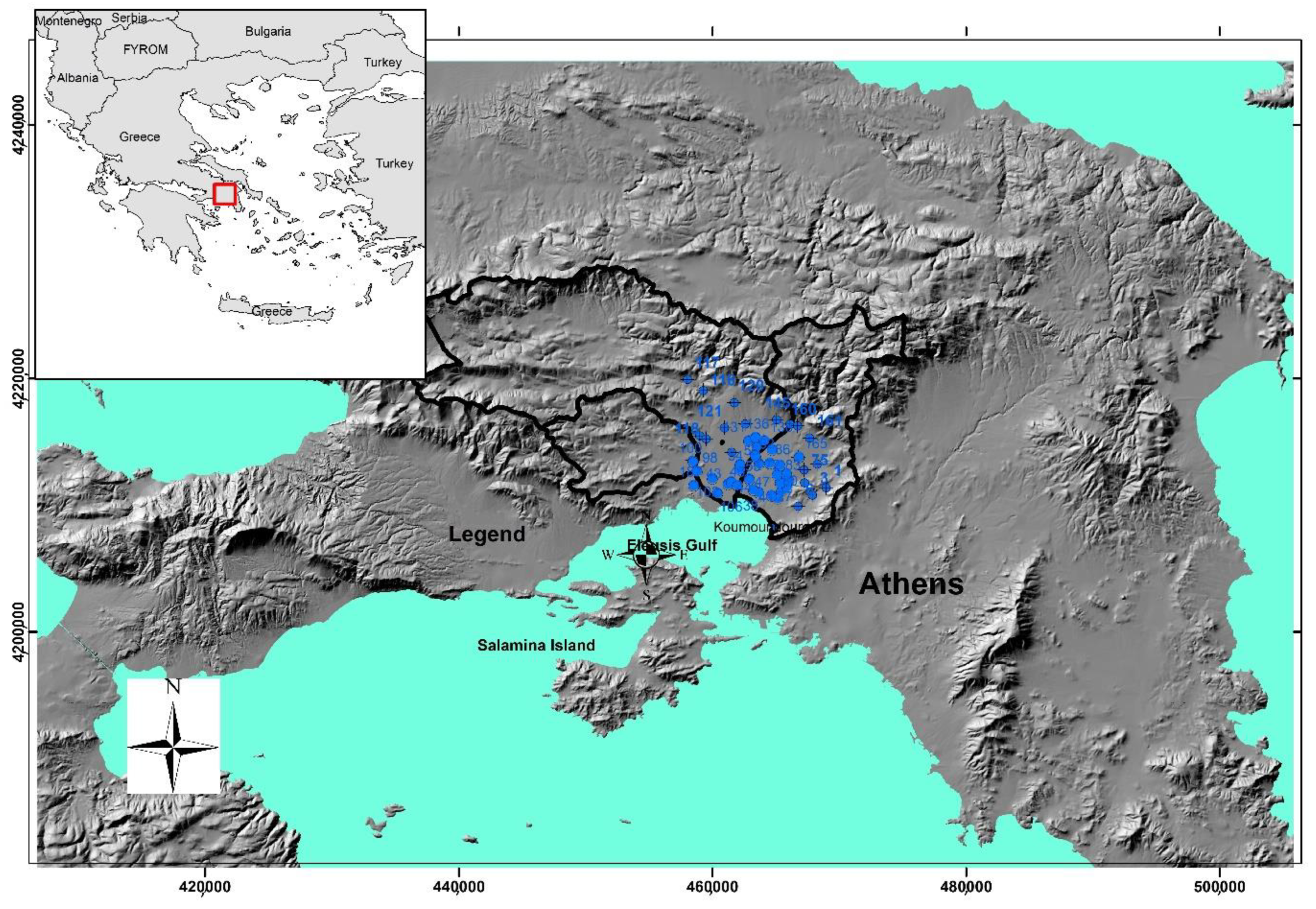
2. Study Area
3. Regional Setting
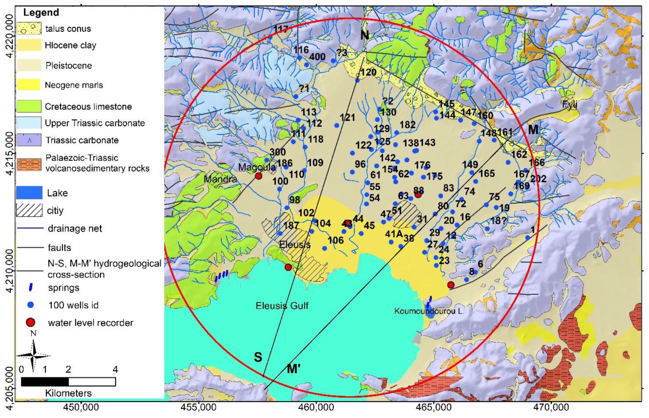
3.1. Geological Setting
3.2. Structural and Lithostratigraphic Setting
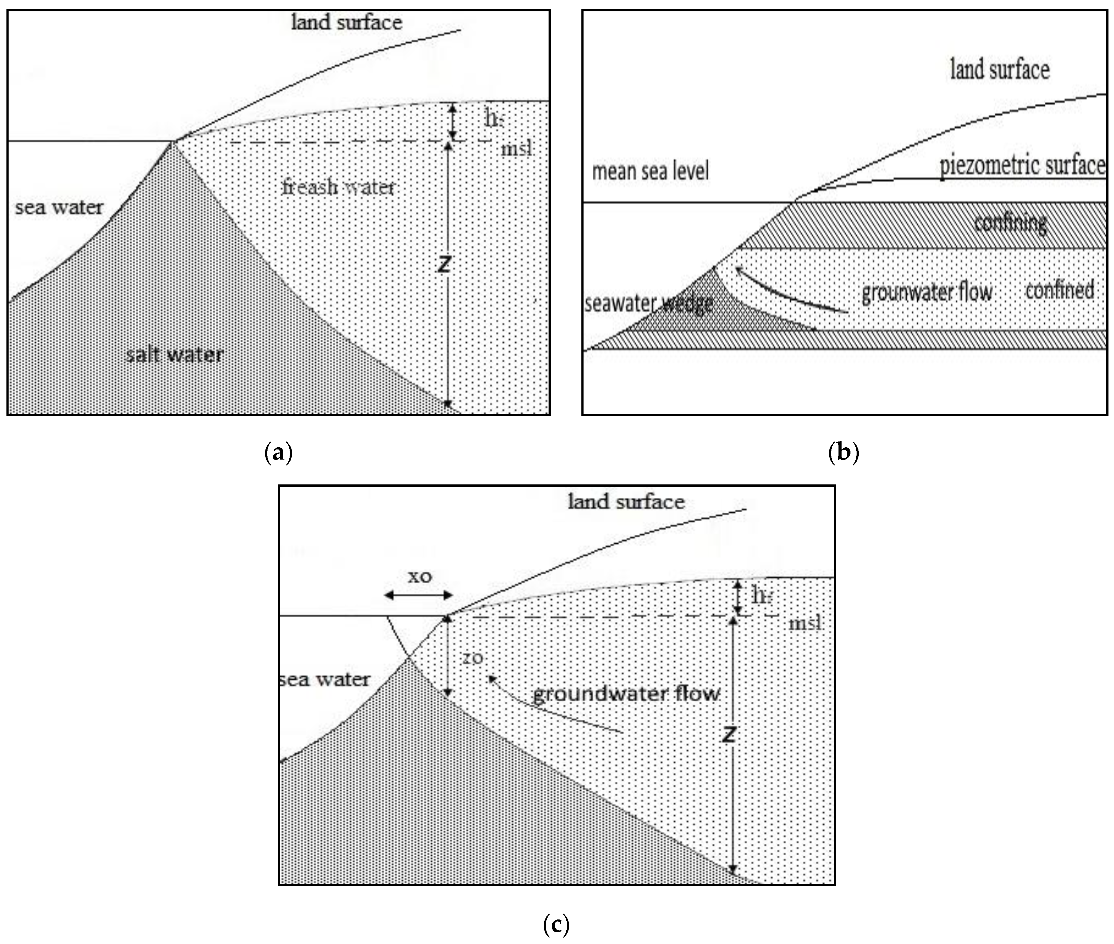
3.3. Hydrogeological-Hydrochemical Setting
4. Materials and Methods
5. Results and Discussion
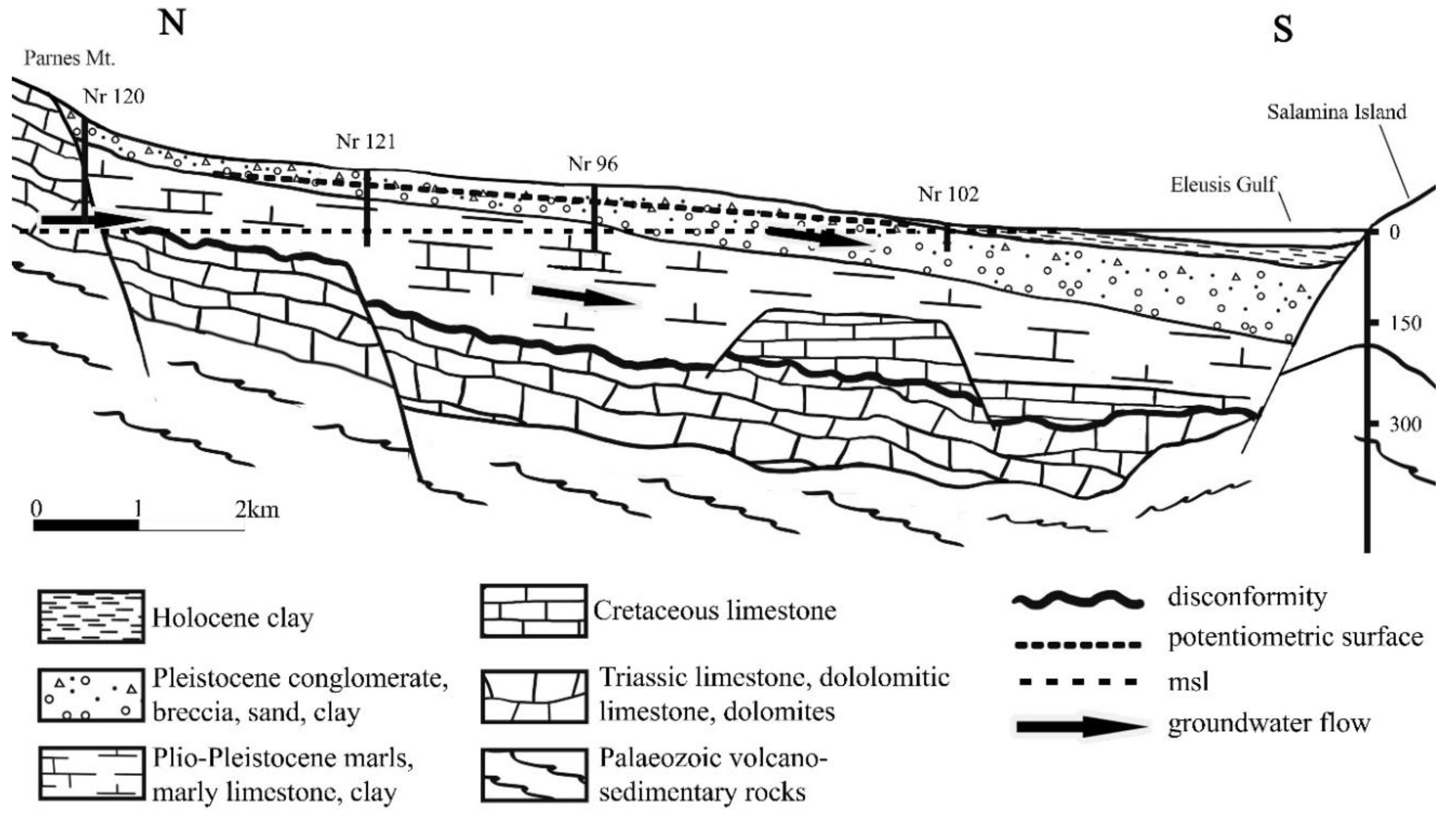
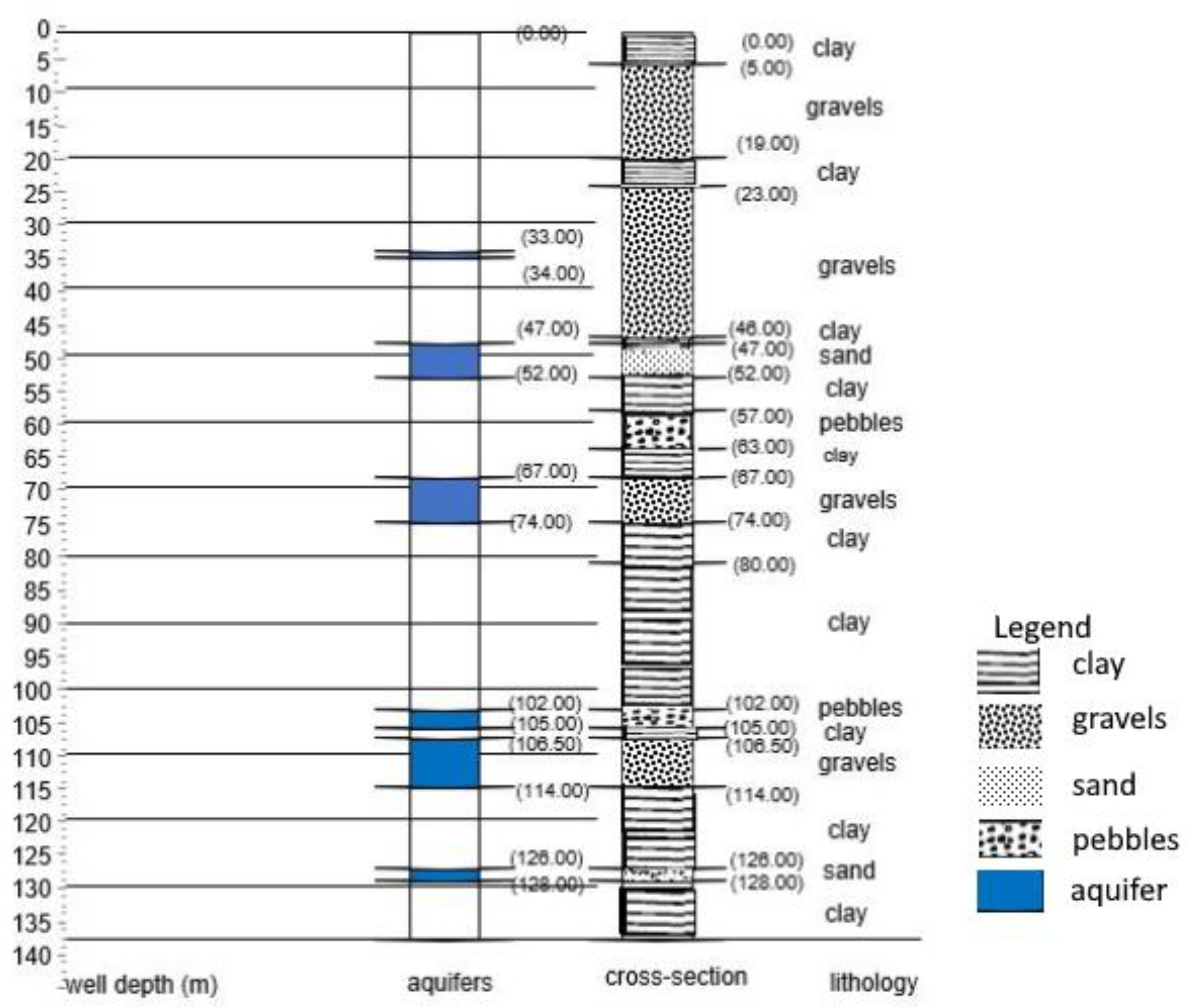
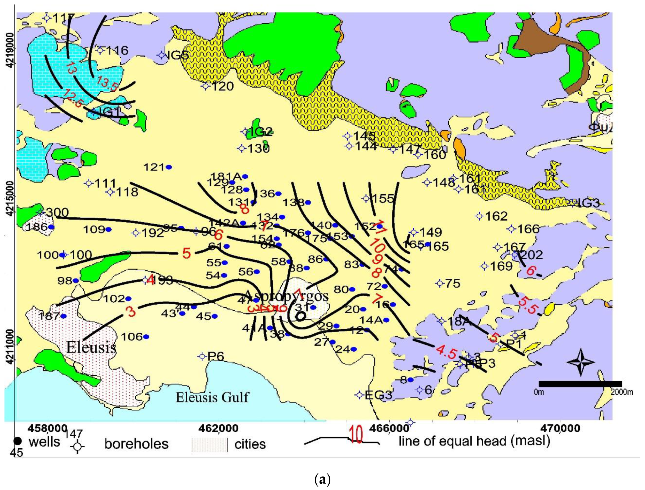
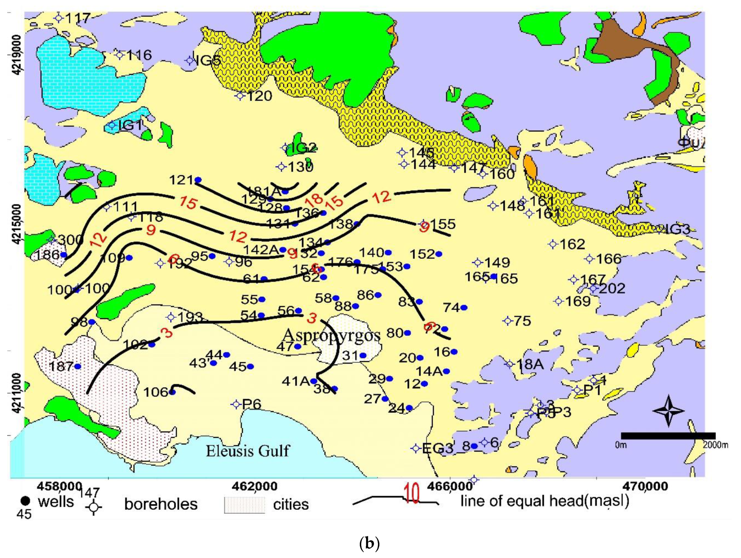
5.1. The Neogene-Quaternary Hydrostratigraphic Unit
5.2. The Cretaceous Unit
5.3. The Triassic Unit
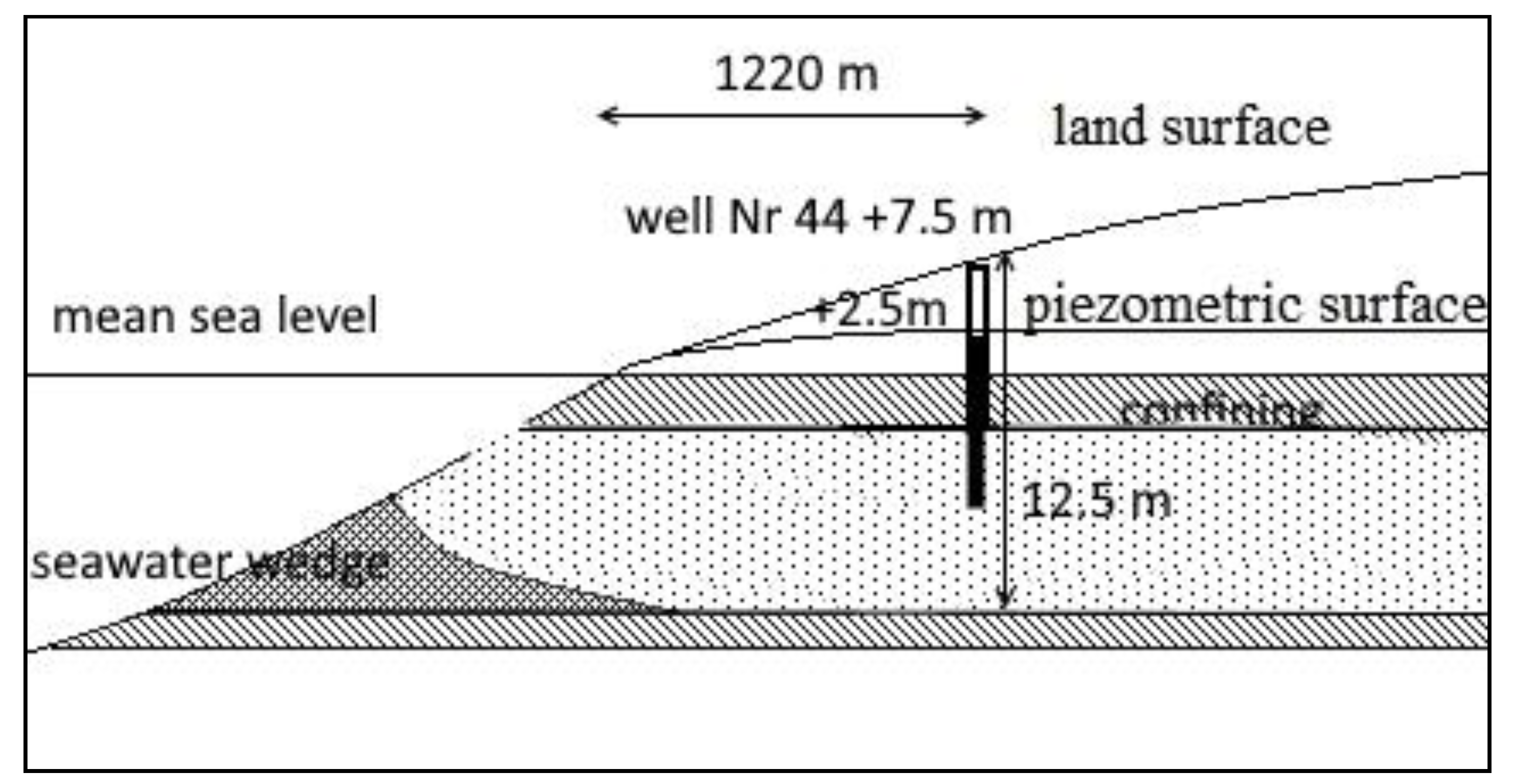
5.4. Conceptual Model
6. Conclusions
Author Contributions
Funding
Acknowledgments
Conflicts of Interest
References
- Post, V.E.A. Groundwater Salinization Processes in the Coastal Area of the Netherlands Due to Transgressions during the Holocene. Ph.D. Thesis, Vrije Universiteit, Amsterdam, The Netherlands, 2004; p. 138. [Google Scholar]
- Fetter, C.W. Applied Hydrogeology, 3rd ed.; Prentice-Hall Inc.: Upper Saddle River, NJ, USA, 1994; p. 600. [Google Scholar]
- Fetter, C.W. Intruded and relict groundwater of marine origin. EOS 1982, 63, 810. [Google Scholar] [CrossRef]
- Custodio, E. Coastal aquifers as important natural hydrogeological structures. In Groundwater and Human Development; Bocanegra, M., Massone, M., Eds.; Taylor & Francis: Barcelone, Spain, 2002; pp. 1905–1918. [Google Scholar]
- Custodio, E.; Bruggeman, G.A. (Eds.) Groundwater Problems in Coastal Areas, Studies and Reports in Hydrology; No. 45, UNESCO; International Hydrological Programme: Paris, France, 1987. [Google Scholar]
- Lloyd, J.W.; Heathcote, J.A. Natural Inorganic Hydrochemistry in Relation to Groundwater; Clarendon Press: Oxford, UK, 1985; p. 296. [Google Scholar]
- Todd, D.K. Groundwater Hydrology; John Wiley and Sons: Hoboken, NJ, USA, 1980; Volume 242, pp. 235–247. [Google Scholar]
- Todd, D.K. Sea water intrusion in coastal aquifers. Trans. Am. Geophys. Union 1953, 34, 749–754. [Google Scholar] [CrossRef]
- Bear, J. Hydraulics of Groundwater; McGraw-Hill: New York, NY, USA, 1979; p. 567. [Google Scholar]
- Freeze, R.A.; Cherry, J.A. Groundwater; Prentice-Hall Inc.: Englewood Cliffs, NJ, USA, 1979; 604p. [Google Scholar]
- Henry, H.R. Interface between salt water and fresh water in a coastal aquifer. In Editors Sea Water in Coastal Aquifers; Cooper, H.H., Jr., Kohout, F.A., Henry, H.R., Glover, R.E., Eds.; U.S. Geological Survey Water Supply: Washington, DC, USA, 1964; pp. C35–C70. [Google Scholar]
- Glover, R.E. The pattern of fresh-water flow in a coastal aquifer. In Sea Water in Coastal Aquifers; U.S. Geological Survey Water-Supply: Washington, DC, USA, 1964; Volume 1613, pp. 32–35. [Google Scholar]
- Hubbert, K.M. The theory of groundwater motion. J. Geol. 1940, 48, 785–944. [Google Scholar] [CrossRef]
- Herzberg, A. Die Wasserversorgung einiger Nordseebder (The water supply of parts of the North Sea coast in Germany). Z. Gasbeleucht Wasserversorg 1901, 44–45, 815–819, 842–844. [Google Scholar]
- Badon-Ghyben, W. Nota in verband met de voorgenomen putboring nabij Amsterdam (Notes on the probable results of well drilling near Amsterdam). Tijdschrift van het Koninklijk Instituut van Ingenieurs 1888, 9, 8–22. [Google Scholar]
- Cheng, A.H.D.; Ouazar, D. Analytical solutions. In Seawater Intrusion in Coastal Aquifers—Concepts, Methods and Practices; Bear, J., Cheng, A.H.D., Sorek, S., Ouazar, D., Herrera, I., Eds.; Kluwer Academic Publishers: Dordrecht, The Netherlands, 1999; pp. 163–191. [Google Scholar]
- Meyer, R.; Engesgaard, P.; Sonnenborg, T.O. Origin and Dynamics of Saltwater Intrusion in a Regional Aquifer: Combining 3-D SaltwaterModeling with Geophysical and Geochemical Data. Water Resour. Res. 2019, 5, 1792–1813. [Google Scholar] [CrossRef]
- Warner, A. On the classification of seawater intrusion. J. Hydrol. 2017, 551, 619–631. [Google Scholar] [CrossRef]
- Bredehoeft, J.D.; Pinder, G.F. Mass transport in flowing groundwater. Water Resour. Res. 1973, 9, 194–210. [Google Scholar] [CrossRef]
- Segol, G.; Pinder, G.F.; Gray, W.G. A Galerkin-finite element technique for calculating the transient position of the saltwater front. Water Resour. Res. 1975, 11, 343–347. [Google Scholar] [CrossRef]
- Custodio, E. Aquifer Overexploitation: What Does It Mean? Hydrogeol. J. 2002, 10, 254–277. [Google Scholar] [CrossRef]
- Jacob, C.A. Flow of groundwater. In Engineering Hydraulics; Rouse, H., Ed.; John Wiley: New York, NY, SUA, 1950; pp. 321–386. [Google Scholar]
- Alam, S.M.M. Hydrogeochemical evolution of groundwater of part of Ganges-Meghna Deltaic Plain. AQUA Mundi 2010, Am03029, 071–082. [Google Scholar]
- Cohen, D.; Person, M.; Wang, P.; Gable, C.W.; Hutchinson, D.; Marksamer, A.; Dugan, B.; Kooi, H.; Groen, K.; Lizarralde, D.; et al. Origin and Extent of Fresh Paleowaters on the Atlantic Continental Shelf, USA. Ground Water 2009, 48, 143–158. [Google Scholar] [CrossRef] [PubMed]
- Edmunds, W.M.; Buckley, D.K.; Darling, W.G.; CJMilne, C.J.; Smedley, P.L.; Williams, A.T. Palaeowaters in the aquifers of the coastal regions of southern and eastern England. Geol. Soc. Lond. Spec. Publ. 2001, 189, 71–92. [Google Scholar] [CrossRef]
- Post, V.; Groen, J.; Kooi, H.; Person, M.; Ge, S.; Edmunds, W.M. Offshore fresh groundwater as a global phenomenon. Nature 2013, 504, 71–78. [Google Scholar] [CrossRef]
- Jiao, J.J.; Shi, L.; Kuang, X.; Lee, C.M.; Yim, W.W.; Yang, S. Reconstructed chloride concentration profiles below the seabed in Hong Kong (China) and their implications for offshore groundwater resources. Hydrogeol. J. 2015, 23, 277. [Google Scholar] [CrossRef]
- Burnett, W.C.; Aggarwal, P.K.; Aureli, A.; Bokuniewicz, H.; Cable, J.E.; Charette, M.A.; Kontar, E.; Krupa, S.; Kulkarni, K.M.; Loveless, A.; et al. Quantifying submarine groundwater discharge in the coastal zone via multiple methods. Sci. Total Environ. 2006, 367, 498–543. [Google Scholar] [CrossRef]
- Hermides, D. Hydrogeological Conditions of the Thriassion Plain Basin with Emphasis on the Geohydraulic Characteristics of the Aquifers and Groundwater Quality. Ph.D. Thesis, Agricultural University of Athens, Athens, Greece, 2018. [Google Scholar]
- Kyriazis, D.; Zagana, E.; Stamatis, G.; Fillippidis, F.; Psomiadis, E. Assessment of groundwater pollution in relation to heavy metals of the alluvial aquifer of Thriassion Plain (NW Attica). Bull. Geol. Soc. Greece 2013, 47, 731–739. [Google Scholar] [CrossRef][Green Version]
- Christides, A.; Mavrakis, A.; Mitilineou, A. A case of intense seawater intrusion to aquifer of the Thriasio Plain. In Proceedings of the 12th International Conference on Environmental Science and Technology, Dodecanese, Greece, 8–11 September 2011; pp. 152–159. [Google Scholar]
- Lioni, A.; Stournaras, G.; Stamatis, G. Degradation of Groundwater quality of Thriassion Plain through Natural Factors and human activity. In Proceedings of the 8th Hydrogeological Congress of Greece, Athens, Greece, 8–10 October 2008; Volume 2, pp. 577–586. [Google Scholar]
- Makri, P. Investigating the Pollution from BTEX in the Groundwater of Thriassion Plain. Ph.D. Thesis, University of Athens, Athens, Greece, 2008; p. 260. [Google Scholar]
- Papanikolaou, D.; Lekkas, E.; Sideris, C. Geology and tectonics of Western Attica in relation to the 7-9-99 earthquake. Newsletter of E.C.P.F.E. Counc. Eur. 1999, 3, 30–34. [Google Scholar]
- Katsikatsos, G.; Mettos, A.; Vidakis, M.; Dounas, A.; Pomoni, F.; Tsaila-Monopolis, S.; Skourtsi-Koroneou, V. Geological Map of Greece, in Scale 1:50.000, “Athina-Elefsis” Sheet; IGME Publication: Athens, Greece, 1986. [Google Scholar]
- Zacharias, A.; Sarandakos, K.; Andre, C. Report on Sample Drilling and Morphotectonics Study in the Area around Koumoundourou Lake; Technical Report; ELKETHE/IIW: Athens, Greece, 2003. [Google Scholar]
- Lionis, M. Hydrogeological Study of Poikilon Mt; ASDA: Athens, Greece, 1992. [Google Scholar]
- Goumas, G. Investigation of the Structure of Thriassion Plain based on Geophysics. Master’s Thesis, University of Athens, Athens, Greece, 2006. [Google Scholar]
- Mariolakos, H.; Fountoulis, I.; Sideris, C.; Chatoupis, T. Morphoneotectonic structure of Parnes’ Mt of Attica Proceedings of the 9th International Congress, Athens. Bull. Geol. Soc. Greece 2001, XXIV/1, 183–190. [Google Scholar]
- Dounas, A. The Geology between Megara and Erithres Area. Ph.D. Thesis, University of Athens, Athens, Greece, 1971. [Google Scholar]
- Poulos, S.; Ghionis, G.; Maroukian, H. Sea-level rise trends in the Attico–Cycladic region (Aegean Sea) during the last 5000 years. Geomorphology 2009, 107, 10–17. [Google Scholar] [CrossRef]
- Mariolakos, H.; Theocharis, D. Shifting shores in the Saronic Gulf during the last 18,000 years and the Kychreia paleolimni. In Proceedings of the 9th International Conference, Bulletin of Hellenic Geological Society, Athens, Greece, September 2001; Volume XXXVI 1, pp. 405–413. [Google Scholar]
- Lambeck, K. Sea level change and shore-line evolution in Aegean Greece since Upper Palaeolithic time. Antiquity 1996, 70/269, 588–611. [Google Scholar] [CrossRef]
- Kambouroglou, E. Eretria Paleogeographic and Geomorphological Evolution during Holocene Relationship of the Natural Environment and Ancient Settlements. Ph.D. Thesis, UNKA, Athens, Greece, 1989; p. 493. [Google Scholar]
- Kallieris, D. Our Village; Cultural Center M. of Aspropyrgos: Aspropyrgos, Greece, 2010; Volume 2, p. 586. [Google Scholar]
- Dounas, A.; Panagiotides, G. Precursor Report on the Hydrogeological Conditions of Thriassion; Institute of Geology and Subsurface Research: Athens, Greece, 1964. [Google Scholar]
- Paraschoudes, Β. Hydrogeological Study of Western Attica; Agricultural Ministry: Athens, Greece, 2002.
- Kounis, G.; Siemos, N. Hydrogeological Research of the Aquifers of Thriassion Plain, for the Water Supply of Hellenic Refinery; IGME: Athens, Greece, 1990; p. 38. [Google Scholar]
- Hermides, D. Geochemical evolution of the Thriassion Plain groundwaters, Attica, Greece. Environ. Monit. Assess 2020, 192, 561. [Google Scholar] [CrossRef]
- Hermides, D.; Stamatis, G. Origin of halogens and their use as environmental tracers in aquifers of Thriassion Plain, Attica, Greece. Environ. Earth Sci. 2017, 76, 306. [Google Scholar] [CrossRef]
- Hopkins, T.S.; Coachman, L.K.; Edwards, R.F. Seasonal change in Elefsis Bay, Greece. Rapp. Comm. Int. Mer. Medit. 1976, 23, 77–80. [Google Scholar]
- Friligos, N.; Barbetseas, S. Water masses and eutrophication in a Greek anoxic marine bay. Toxicol. Environ. Chem. 1990, 28, 11–23. [Google Scholar] [CrossRef]
- Theis, C.V. The relation between the lowering of the piezometric surface and the rate and duration of discharge of a well using ground water storage. Trans. Am. Geophys. Union 1935, 16, 519–524. [Google Scholar] [CrossRef]
- Cooper, H.H.; Jacob, C.E. A generalized graphical method for evaluating formations constants and summarizing well-field history. Trans. Am. Geophys. Union 1946, 27, 526–534. [Google Scholar] [CrossRef]
- Neumann, S.P. Analysis of pumping test data from anisotropic unconfined aquifers considering delayed gravity response of the water table. Water Resour. Res. 1975, 11, 329–342. [Google Scholar] [CrossRef]
- Papadopulos, I.S.; Cooper, H.J. Drawdown in a well of large diameter. Water Resour. Res. 1967, 3, 241–244. [Google Scholar] [CrossRef]
- Schafer, D.C. Casing Storage can Affect Pumping Test Data; Johnson Drillers’ Journal, Jan/Feb, Johnson Division, UOP Inc.: St. Paul, MI, USA, 1978. [Google Scholar]
- Edmunds, W.M.; Smedley, P.L. Fluoride in natural waters. In Essentials of Medical Geology; Selinus, O., Ed.; Springer: Enschede, The Netherlands, 2013; pp. 311–336. [Google Scholar]
- Tal, A.; Weinstein, Y.; Wollman, S.; Goldman, M.; Yechieli, Y. The Interrelations between a Multi-Layered Coastal Aquifer, a Surface Reservoir (Fish Ponds), and the Sea. Water 2018, 10, 1426. [Google Scholar] [CrossRef]
- Bakalowicz, M. Coastal Karst Groundwater in the Mediterranean: A Resource to Be Preferably Exploited Onshore, Not from Karst Submarine springs. Geosciences 2018, 8, 258. [Google Scholar] [CrossRef]


| HSU | Well Nr | Distance from Shore (m) | Site Elevation (m) | Well Depth (m) | Head (masl) | TDS (mg/L) | Cl− (mmol/L) | Na+ (mmol/L) | Ca2+ (mmol/L) | Mg2+ (mmol/L) | K+ (mmol/L) | NO3− (mmol/L) | SO42− (mmol/L) | HCO3− (mmol/L) |
|---|---|---|---|---|---|---|---|---|---|---|---|---|---|---|
| Triassic carbonate | 6 | 2559 | 50 | 60 | 2074 | 21.7 | 20.8 | 7.7 | 6.2 | 0.5 | 0.8 | 2.7 | 6.9 | |
| 18 | 4000 | 58 | 60 | 2476 | 29.9 | 23.8 | 7.4 | 6.6 | 0.5 | 0.4 | 2.5 | 7.8 | ||
| 111 | 5041 | 63.5 | 85 | 1463 | 16.4 | 12.0 | 6.6 | 4.4 | 0.2 | 0.6 | 1.4 | 5.5 | ||
| 121 | 5496 | 74 | 412 | 1.1 | 1.0 | 2.7 | 2.9 | 0.0 | 0.6 | 0.2 | 4.0 | |||
| 169 | 5690 | 69.51 | 85 | 1731 | 11.7 | 10.8 | 7.5 | 5.0 | 0.3 | 0.5 | 1.2 | 9.2 | ||
| 202 | 6080 | 76.5 | 80 | 6.17 | ||||||||||
| 147 | 6735 | 140 | 137 | 1259 | 12.3 | 10.7 | 4.5 | 3.6 | 0.5 | 0.2 | 2.3 | 5.0 | ||
| 162 | 6800 | 140 | 140 | 354 | 1.0 | 1.0 | 2.7 | 2.1 | 0.0 | 1.1 | 0.3 | 3.3 | ||
| 116 | 8625 | 115 | 154 | 13.63 | 900 | 7.2 | 5.8 | 5.9 | 3.0 | 0.2 | 0.6 | 0.9 | 5.0 | |
| 117 | 9410 | 175 | 220 | 12.63 | 950 |
| HSU | Well Nr | Distance from Shore (m) | Site Elevation (m) | Well Depth (m) | Head (masl) | TDS (mg/L) | Cl− (mmol/L) | Na+ (mmol/L) | Ca2+ (mmol/L) | Mg2+ (mmol/L) | K+ (mmol/L) | NO3− (mmol/L) | SO42− (mmol/L) | HCO3− (mmol/L) |
|---|---|---|---|---|---|---|---|---|---|---|---|---|---|---|
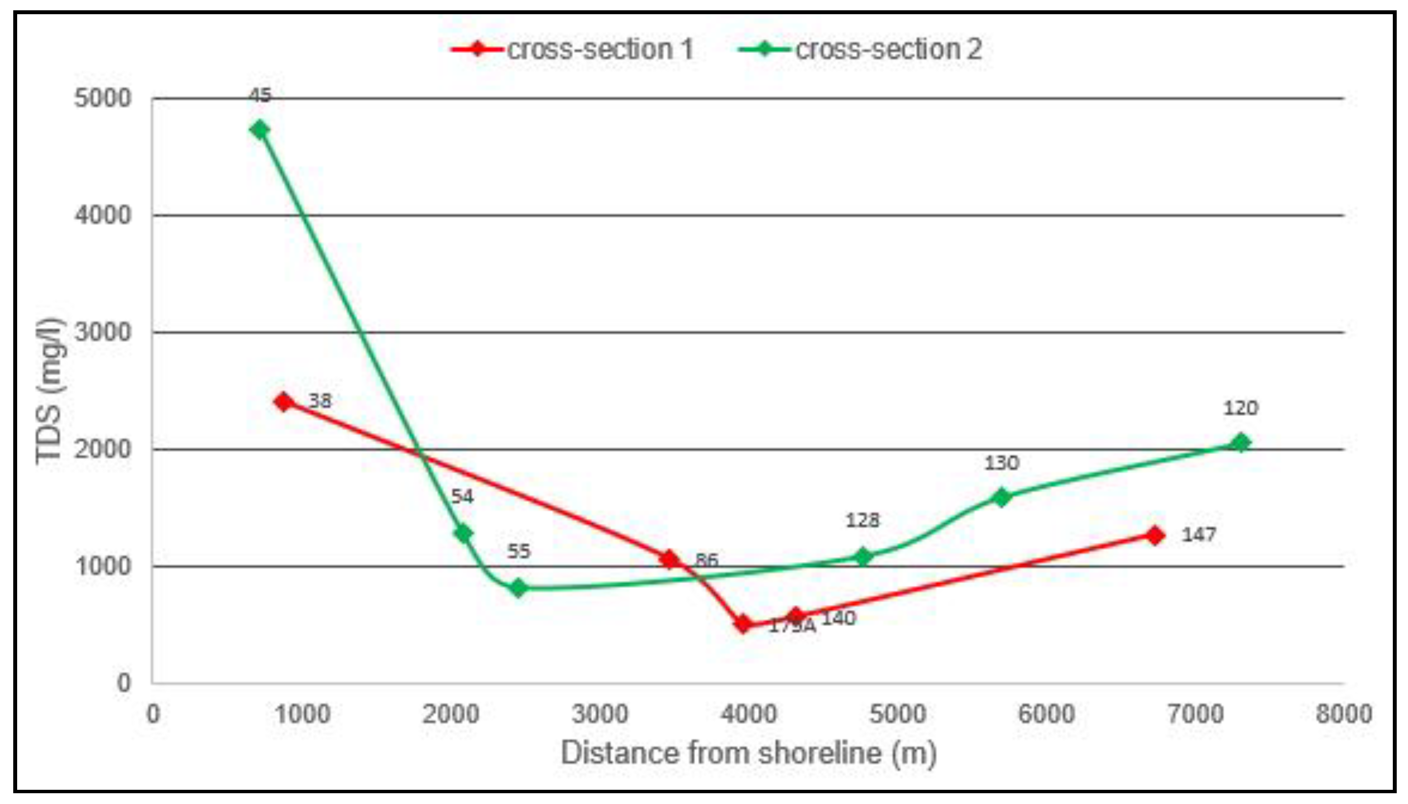
| Cretaceous limestone | 96 | 3460 | 38 | 76 | 4.8 | 1980 | 21.1 | 16.4 | 6.1 | 9.3 | 0.4 | 1.0 | 1.8 | 8.3 |
| 118 | 4938 | 64 | 80 | 2695 | 36.5 | 28.1 | 7.2 | 7.3 | 0.5 | 0.4 | 3.1 | 5.6 | ||
| 130 | 5697 | 81.35 | 95 | 1452 | 16.5 | 11.8 | 8.2 | 5.3 | 0.1 | 2.3 | 2.7 | 3.7 | ||
| 120 | 7303 | 145 | 180 | 2044 | 27.1 | 20.9 | 5.3 | 5.4 | 0.4 | 0.2 | 2.1 | 5.0 |
| HSU | Well Nr | Distance from Shore (m) | Site Elevation (m) | Well Depth (m) | Head (masl) | TDS (mg/L) | Cl− (mmol/L) | Na+ (mmol/L) | Ca2+ (mmol/L) | Mg2+ (mmol/L) | K+ (mmol/L) | NO3− (mmol/L) | SO42− (mmol/L) | HCO3− (mmol/L) |
|---|---|---|---|---|---|---|---|---|---|---|---|---|---|---|
| Confined Plio-Pleistocene subunit | 24 | 1586 | 14.88 | 20 | 4.83 | 2869 | 34.0 | 29.6 | 7.7 | 8.9 | 0.7 | 2.2 | 3.6 | 8.5 |
| 31 | 1862 | 23.91 | 24 | 8.39 | ||||||||||
| 29 | 1884 | 22.53 | 30 | 5.24 | ||||||||||
| 20 | 1897 | 34.8 | 45 | 5.87 | 1843 | 18.8 | 11.7 | 8.7 | 10.0 | 0.1 | 1.9 | 4.9 | 5.9 | |
| 54 | 2125 | 19.77 | 25 | 4.66 | 1177 | 5.7 | 12.2 | 3.2 | 3.2 | 0.3 | 1.8 | 2.2 | 7.7 | |
| 12 | 2152 | 23 | 23 | 6.33 | 1653 | 15.0 | 12.1 | 8.4 | 7.9 | 0.3 | 3.2 | 3.1 | 6.6 | |
| 55 | 2459 | 23.45 | 25 | 4.93 | 717 | 1.8 | 3.1 | 4.7 | 3.9 | 0.1 | 1.7 | 0.8 | 6.5 | |
| 88 | 2794 | 42.61 | 45 | 6.21 | ||||||||||
| 58 | 2814 | 38.53 | 40 | 3.72 | 1127 | 8.9 | 2.9 | 9.6 | 10.7 | 0.1 | 6.4 | 2.3 | 5.0 | |
| 100 | 2944 | 33.7 | 56 | 751 | 2.0 | 1.7 | 6.4 | 3.0 | 0.1 | 1.2 | 0.4 | 7.3 | ||
| 61 | 3005 | 28.49 | 40 | 4.98 | ||||||||||
| 80 | 3105 | 41.28 | 45 | 7.46 | 1985 | 24.5 | 12.7 | 12.3 | 9.8 | 0.1 | 2.5 | 3.5 | 4.6 | |
| 16 | 3196 | 36.2 | 41 | 6.24 | ||||||||||
| 62 | 3260 | 45.24 | 70 | 6 | 706 | 5.4 | 1.5 | 6.6 | 6.1 | 0.1 | 3.6 | 0.6 | 3.9 | |
| 86 | 3467 | 50.72 | 60 | 6.32 | 849 | 6.7 | 2.2 | 8.1 | 6.3 | 0.1 | 3.5 | 1.3 | 4.1 | |
| 142 | 3738 | 38.44 | 50 | 7.73 | ||||||||||
| 186 | 3750 | 51.07 | 50 | 17.54 | ||||||||||
| 132 | 3793 | 50.76 | 60 | 7.23 | ||||||||||
| 109 | 3910 | 43 | 45 | 3.41 | ||||||||||
| 83 | 3912 | 58.26 | 65 | 7.08 | 862 | 7.4 | 7.0 | 4.0 | 2.9 | 0.1 | 1.1 | 0.9 | 4.5 | |
| 175A | 4000 | 63.18 | 80 | 7.6 | 398 | 1.4 | 0.9 | 3.3 | 2.8 | 0.0 | 1.7 | 0.5 | 3.3 | |
| 134 | 4082 | 56.1 | 80 | 7.83 | 690 | 2.6 | 1.9 | 6.3 | 6.0 | 0.1 | 4.7 | 1.4 | 4.6 | |
| 74 | 4156 | 64.2 | 70 | 8.14 | ||||||||||
| 140 | 4313 | 73.25 | 90 | 8.58 | 441 | 1.9 | 1.0 | 4.3 | 3.1 | 0.1 | 2.0 | 0.4 | 3.3 | |
| 131 | 4391 | 47.84 | 65 | 9.05 | 751 | 4.5 | 1.8 | 6.8 | 6.3 | 0.1 | 3.8 | 0.9 | 4.7 | |
| 75 | 4690 | 61.5 | 106 | 783 | 3.9 | 1.7 | 7.5 | 5.8 | 0.2 | 4.3 | 1.0 | 5.4 | ||
| 138 | 4729 | 73.85 | 170 | 8.78 | 670 | 6.9 | 1.8 | 5.4 | 4.4 | 0.1 | 0.6 | 0.2 | 3.3 | |
| 128 | 4764 | 51.34 | 80 | 9.68 | 698 | 4.6 | 1.5 | 7.2 | 7.0 | 0.2 | 6.3 | 0.5 | 3.9 | |
| 136 | 4769 | 59.13 | 80 | 7 | 891 | 8.9 | 3.0 | 6.8 | 6.5 | 0.1 | 2.2 | 0.7 | 4.1 | |
| 129 | 4940 | 58.7 | 80 | 16.05 | ||||||||||
| 165 | 5148 | 86.21 | 100 | 13.18 | ||||||||||
| 181 | 5172 | 56 | 107 | 25.68 | ||||||||||
| Unconfined Holocene-Pleistocene subunit | 41 | 800 | 8.81 | 15 | 3.03 | 1683 | 10.4 | 16.8 | 5.8 | 5.1 | 0.1 | 2.9 | 2.8 | 9.9 |
| 38 | 872 | 9.3 | 11 | 2.58 | 2337 | 26.4 | 18.1 | 11.1 | 8.6 | 0.3 | 1.2 | 3.9 | 7.3 | |
| 45 | 883 | 4.72 | 6.2 | 1.9 | 4318 | 59.5 | 48.4 | 10.9 | 12.4 | 0.7 | 6.7 | 6.6 | 6.3 | |
| 106 | 1010 | 5.91 | 8.5 | 0.96 | 3243 | 40.8 | 32.5 | 11.1 | 9.5 | 0.5 | 1.5 | 4.8 | 7.4 | |
| 187 | 1100 | 13.02 | 14 | 3.85 | 1406 | 15.6 | 12.4 | 4.7 | 4.5 | 0.4 | 0.4 | 1.4 | 5.4 | |
| 43 | 1156 | 5.1 | 5.93 | 1.8 | 2184 | 27.7 | 25.1 | 4.7 | 5.9 | 0.6 | 2.5 | 2.6 | 5.1 | |
| 47 | 1200 | 10.5 | 11.93 | 1.64 | 5026 | 80.7 | 34.6 | 24.8 | 26.8 | 0.6 | 3.5 | 4.6 | 4.5 | |
| 44 | 1222 | 7.51 | 9.8 | 2.52 | 1298 | 12.2 | 12.9 | 3.2 | 3.7 | 0.4 | 0.2 | 1.4 | 6.1 | |
| 27 | 1423 | 16.36 | 16 | 3.79 | 2608 | 29.2 | 27.7 | 9.3 | 7.5 | 0.4 | 0.8 | 4.0 | 7.2 | |
| 98 | 2200 | 25.98 | 32 | 5.26 | 1108 | 6.9 | 6.5 | 6.2 | 4.1 | 0.3 | 0.6 | 1.4 | 7.5 | |
| 102 | 2228 | 14.39 | 20 | 3.13 | 2395 | 26.0 | 22.9 | 7.6 | 8.5 | 0.4 | 2.5 | 3.0 | 8.5 | |
| 14 | 2601 | 28 | 30 | 4.68 | 3161 | 42.1 | 27.5 | 15.2 | 10.3 | 0.3 | 2.7 | 5.1 | 5.3 | |
| 100′ | 2945 | 33.9 | 35 | 9.36 | ||||||||||
| 154 | 3424 | 46.62 | 65 | 6.3 | 646 | 2.7 | 1.8 | 6.6 | 6.2 | 0.2 | 5.6 | 1.0 | 4.0 | |
| 72 | 3469 | 50.88 | 60 | 6.88 | 889 | 7.0 | 3.6 | 6.2 | 6.0 | 0.2 | 2.1 | 0.9 | 5.0 |
Publisher’s Note: MDPI stays neutral with regard to jurisdictional claims in published maps and institutional affiliations. |
© 2020 by the authors. Licensee MDPI, Basel, Switzerland. This article is an open access article distributed under the terms and conditions of the Creative Commons Attribution (CC BY) license (http://creativecommons.org/licenses/by/4.0/).
Share and Cite
Hermides, D.; Makri, P.; Kontakiotis, G.; Antonarakou, A. Advances in the Coastal and Submarine Groundwater Processes: Controls and Environmental Impact on the Thriassion Plain and Eleusis Gulf (Attica, Greece). J. Mar. Sci. Eng. 2020, 8, 944. https://doi.org/10.3390/jmse8110944
Hermides D, Makri P, Kontakiotis G, Antonarakou A. Advances in the Coastal and Submarine Groundwater Processes: Controls and Environmental Impact on the Thriassion Plain and Eleusis Gulf (Attica, Greece). Journal of Marine Science and Engineering. 2020; 8(11):944. https://doi.org/10.3390/jmse8110944
Chicago/Turabian StyleHermides, Demetrios, Panayota Makri, George Kontakiotis, and Assimina Antonarakou. 2020. "Advances in the Coastal and Submarine Groundwater Processes: Controls and Environmental Impact on the Thriassion Plain and Eleusis Gulf (Attica, Greece)" Journal of Marine Science and Engineering 8, no. 11: 944. https://doi.org/10.3390/jmse8110944
APA StyleHermides, D., Makri, P., Kontakiotis, G., & Antonarakou, A. (2020). Advances in the Coastal and Submarine Groundwater Processes: Controls and Environmental Impact on the Thriassion Plain and Eleusis Gulf (Attica, Greece). Journal of Marine Science and Engineering, 8(11), 944. https://doi.org/10.3390/jmse8110944