Concept Paper

SBAS/EGNOS for Maritime

by
Manuel Lopez-Martinez
1,
José-Manuel Álvarez
2,
José-Maria Lorenzo
2 and
Carlos Garcia Daroca
2,*
1
GSA, European Global Navigation Satellite Systems Agency, 170 00 Prague, Czech Republic
2
ESSP, European Satellite Services Provider, 28850 Madrid, Spain
*
Author to whom correspondence should be addressed.
J. Mar. Sci. Eng. 2020, 8(10), 764; https://doi.org/10.3390/jmse8100764
Submission received: 28 August 2020 / Revised: 10 September 2020 / Accepted: 12 September 2020 / Published: 30 September 2020
(This article belongs to the Special Issue GNSS and Geomatics Application for Navigation and Marine Engineering)

Abstract

:
The Global Navigation Satellite System (GNSS) has become the primary means of obtaining Position, Navigation, and Timing (PNT) information at sea. The current capabilities of the Global Positioning System (GPS) constellation, although adequate for ocean navigation, have some shortfalls for coastal navigation: some user communities have a need for enhanced performance and they can benefit from the available “augmentation” techniques, resulting in improved GPS performance. Nowadays, the users can take advantage of Satellite-Based Augmentation Systems (SBASs). The maritime domain has been used SBAS for several years and it is supported by GNSS receivers used in the recreational and professional sectors. The SBAS/European Geostationary Navigation Overlay Service (EGNOS) can be used to complement the differential GNSS (DGNSS) for the provision of enhanced accuracy and integrity information with additional benefits. There are different possible solutions for the transmission of SBAS/EGNOS information to maritime users, considering that the corrections can be available from different transmission means. The different options for the use of SBAS for maritime navigation, the benefits brought to mariners, as well as the associated regulations, standardization and service provision aspects, are presented in this article.

1. Introduction

The Global Navigation Satellite System (GNSS) has become the primary means of obtaining Position, Navigation, and Timing (PNT) information at sea. The introduction of the GNSS represented a revolution in the field since 1995, when the Global Positioning System (GPS) met full operational capability. Performance standards for shipborne GPS receiver equipment were rapidly adopted and GPS and GLONASS were recognized by the International Maritime Organization (IMO) as part of the World-Wide Radio Navigation Systems (WWRNS) for ocean water navigation. Since then, GNSS positioning has progressively acquired increasing relevance to all ships operating across the globe. Additionally, nowadays most of the ships in the world are equipped with GNSS receivers (International Convention for the Safety of Life at Sea (SOLAS) carriage requirement) and Galileo and Beidou have become also part of the WWRNS [1,2]. The purpose of this article is to introduce the SBAS service layer which is built on top of the base GNSS constellations. SBAS added values have been exploded by the mariners since several years ago, bringing them an enhanced accuracy in the position and integrity information of the system. Thus, the multiple alternatives for the use of SBAS in the maritime domain, the regulatory framework and details of a maritime SBAS service are introduced in this article.

2. Satellite Based Augmentation Systems (SBAS)

The International Association of Marine Aids to Navigation and Lighthouse Authorities (IALA) DGNSS is the internationally accepted method of providing differential GNSS corrections and integrity information to maritime users. Nowadays, the users can take advantage of Satellite-Based Augmentation Systems (SBAS). SBAS are designed to augment the GNSS by providing correction data and integrity information to improve the positioning, navigation and timing solutions.
The maritime domain has been used GNSS and SBAS for several years and it is supported by GNSS receivers used in the recreational and professional sectors. The total amount of GNSS shipments for 2020 accumulated to 1.9 million units across the three main categories of applications (i.e., navigation, positioning and search and rescue)—Figure 1.
The SBAS provides an important added value not only when used in general navigation, but also in many other maritime applications, including SAR, homeland security and traffic management. Therefore, many maritime GNSS receivers used in the recreational and professional sectors (c.a. 90% of maritime receiver models for SOLAS and non-SOLAS vessels) are SBAS enabled. Furthermore, although the implementation of SBAS in maritime receivers is not yet standardized, around 90% of manufacturers are offering at least one receiver model that is SBAS-enabled.

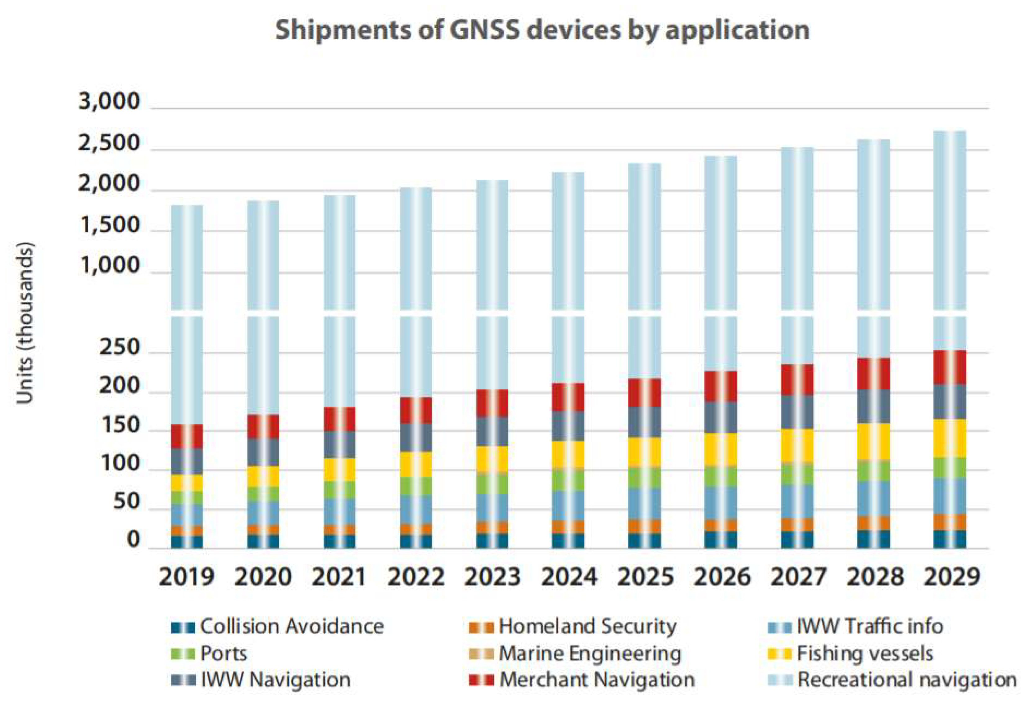
3. SBAS in the Maritime Domain

SBAS systems are able to provide, over a wide area, the same type of information offered by a DGNSS service (i.e., differential corrections and system integrity information) which can be used to improve the position estimation accuracy and to protect the user from possible system-related failures. Therefore, depending on the application requirements, SBAS can be used to effectively complement DGNSS in maritime and inland waterway domains, with performances in the same order of magnitude than the DGNSS ones (e.g., accuracy < 5 m (95%)—IALA Guideline 1112). The main SBAS generic benefits for maritime applications can be summarized as follows:
  • SBAS provides increased accuracy, availability and continuity in comparison with other navigation aids and in line with IMO resolution A.1046(27) [4] contributing to the safety of navigation;
  • SBAS comply with common global standards and are compatible and interoperable, thus providing the user with a “seamless”, augmented, navigation solution in the regions where it is available, as depicted in Figure 2.
  • SBAS services are available for free;
  • SBAS services cover large areas including locations currently not served by other navigation aids. SBAS services are able to complement the coverage area of a DGNSS service to increase the availability and the continuity of the provision of correction data and integrity information;
  • In some cases, SBAS may support the rationalization of ground-based navigation aids;
  • In some cases (e.g., EGNOS Service Definition Documents), and in contrast to other GNSS services, it can be put in force the commitment between the AtoN providers or Maritime Authorities and the SBAS service provider establishing the terms conditions to guarantee the appropriate service level.
However, in the case of SBAS Signal in Space (SiS) direct use, there are also some limitations to be considered and dealt with, for instance those related to:
  • Not Global SBAS coverage yet. The Northern Hemisphere is highly covered and the trend goes in the direction to cover the widest worldwide areas;
  • Common GNSS vulnerabilities: interferences, jamming and spoofing.

4. SBAS/EGNOS for Maritime Navigation

EGNOS (European Geostationary Navigation Overlay Service) is the European SBAS providing an augmentation service to the Global Positioning System (GPS) and in the future to Galileo. The ongoing initiatives for the implementation of SBAS/EGNOS services for maritime considers that the corrections can be available from different transmission means, such as SBAS Signal in Space, through existent IALA radio-beacon and AIS stations.

4.1. SBAS/EGNOS Signal in Space (SiS)

This is expected to be the most straightforward solution and the most employed approach to SBAS data received directly from the satellites. This option allows directly receiving and applying the SBAS message transmitted by the SBAS satellites to the on-board user receiver to increase the navigation solution accuracy and integrity.

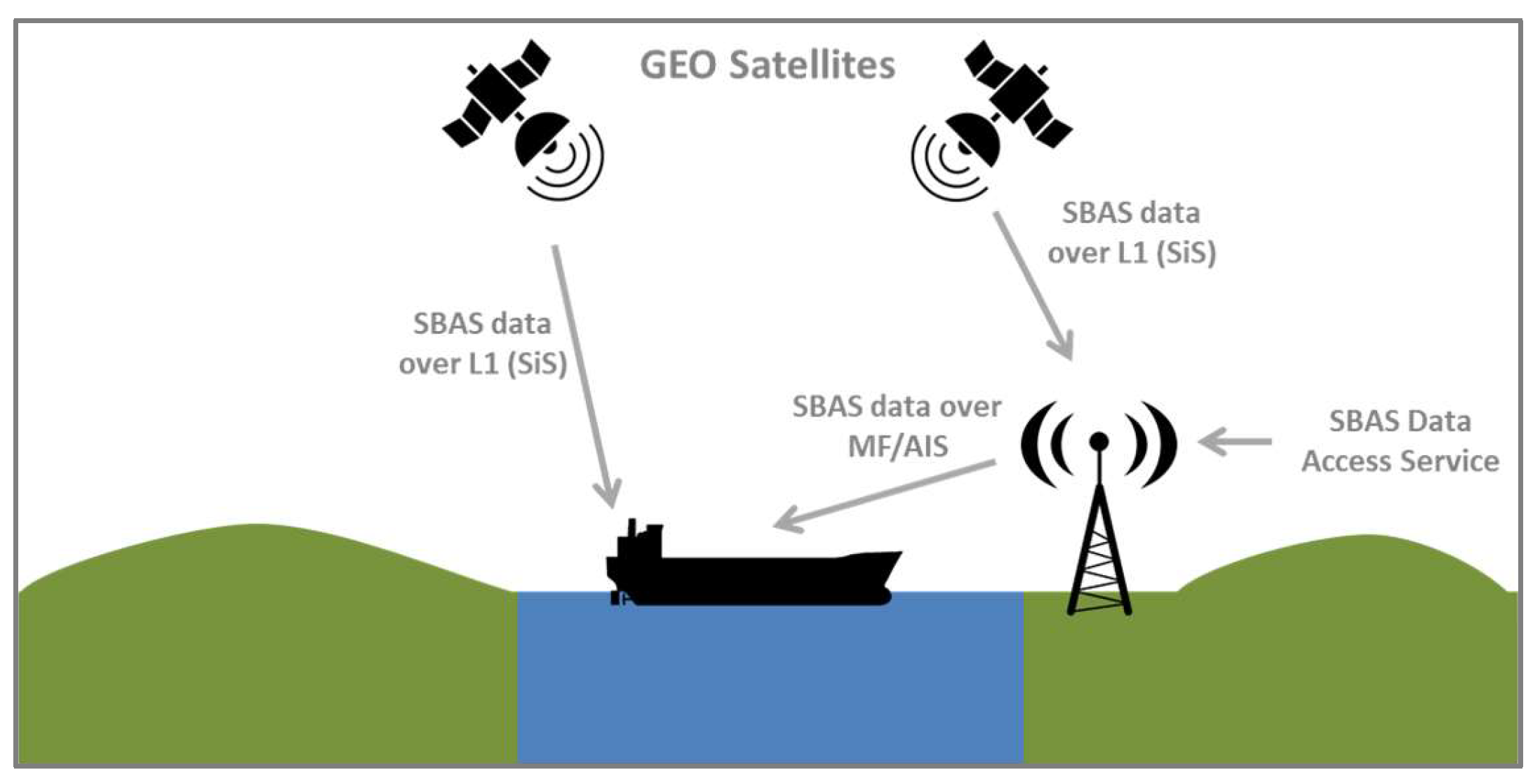
4.2. SBAS/EGNOS Data Used via IALA MF Radiobeacons or AIS

In this approach, SBAS data is provided to an AtoN provider, which broadcasts the information to the mariners over an existing marine radio service currently used such as marine beacon 300 kHz and VHF frequencies used for AIS. In this case, two options can be used for accessing to the SBAS data: SiS and Internet (available for EGNOS via EDAS service [6]). A concept diagram is presented in Figure 3.
Taking into account these different transmission means, the GSA has defined a strategy for the introduction of the EGNOS maritime services, based on three complementary work streams, as it is introduced in Figure 4:
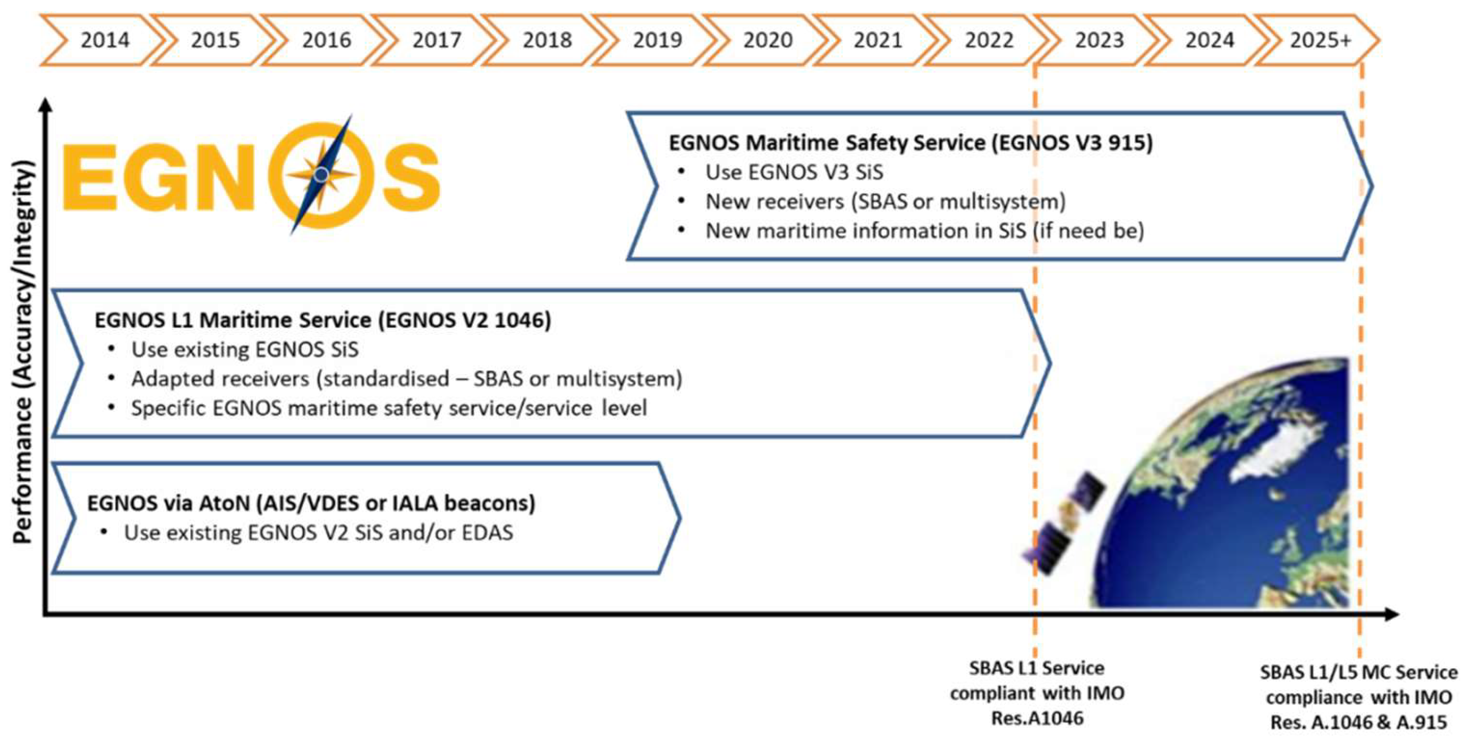
  • Phase 1: Transmission of EGNOS corrections over existing infrastructure (IALA DGPS beacons and AIS stations);
  • Phase 2: The use of EGNOS v2 Signal in Space (L1—signal already available), a service aligned with IMO A.1046(27) [4];
  • Phase 3: The use of EGNOS v3 Signal in Space (L1 and L5—signal available from 2025+), a maritime service aligned with IMO A.1046 (27) [4] and A.915(22) [7].

5. SBAS/EGNOS Signal in Space Use

SBAS/EGNOS is currently able to comply with the IMO Resolution A.1046 (27) [4] requirements for navigation in Ocean waters and in harbor entrances, harbor approaches and coastal waters, in its coverage area—Table 1.
The following work streams aim at establishing the technical, regulatory and standardization framework for the use of SBAS SiS on board the vessels for a safe navigation.
  • IALA Guidance on Augmentation Systems—IALA ENG Committee has been working on guidance material with all the aspects that maritime or coastal administrations may take into account when considering the use of SBAS on ships in their waters. Two IALA Guidelines on the use of SBAS are available at the IALA website: IALA Guideline 1129 [8] focused on the retransmission of SBAS corrections using MF radio beacons and AIS stations, and (2) IALA Guidelines 1152 on the SBAS Maritime Service (SBAS SiS) [9].
  • User and SBAS Receivers Standardization—The standardization activities are key to the provision of a SBAS Service in the maritime domain. The approach to the use of SBAS/EGNOS SiS for safe maritime navigation considers the reception of the L1 signal directly on-board the vessels with type approved receivers following a standardized implementation (type approved receivers according to the new standard to be developed. The development of a standard for SBAS on-board receivers is planned to be developed at IEC level (IEC TC80—maritime navigation and radio communication equipment and systems), where it is expected to agree with the corresponding Test Specification (in a working period of two years). Then, receiver manufacturers will be able to follow the IEC approved Test Specification to develop, build and type approve maritime SBAS user equipment.
For this task, EC/GSA will provide as input the Guidelines for manufacturers for the implementation of SBAS in Shipborne Receivers, developed by the EC/GSA in coordination with ESA and ESSP, which describes the minimum set of SBAS messages to be processed to be compliant with IMO resolution A.1046(27) [4]. These Guidelines, that include also test specifications, were finalized with the inputs from the RTCM SC-104 and validated with the outcomes of a GSA/EC funded project (Fundamental Elements MAREC project) with the objective to implement a software update in a SBAS L1 maritime receiver and run the tests.
3.
Service Provision Scheme ([10] Section 6)—In order to guarantee an adequate level of SBAS service for the maritime users, a service provision scheme should be established, addressing at least:
o
Operation and maintenance;
o
Performance verification;
o
Publication of information (including the provision of EGNOS related maritime safety information).
An example of such a potential scheme, aligned with IALA Guideline 1152, proposed for the EGNOS maritime service, and agreed among different maritime authorities and relevant stakeholders at the European Maritime Radio-navigation Forum (EMRF [11]), is presented in next figure:
The end users may benefit from the EGNOS enhanced performance by means of the following channels:
  • Reception of SiS on-board the vessels with type approved receivers (see (1) in the Figure 5).
  • On the basis of the Service Definition Document (SDD) terms and conditions, the establishment of a potential working agreement between the ESP and the national competent authority (if requested by authority) laying down the technical modalities and required operational interfaces, for the delivery of this service (see (2) in Figure 5).
  • Provision of EGNOS Maritime Safety Information (MSI) to the end users of the EGNOS L1 maritime service (see (3) (5) and (6) in Figure 5).

SBAS/EGNOS Maritime Safety Information (MSI)

The SBAS/EGNOS MSI service is aimed at providing timely information to users on any deviation from the committed performance in line with the Joint IMO/IHO/WMO Manual on Maritime Safety Information [12] and as indicated in the IMO A.1046 (27) operational requirements [4].
Depending on the specific characteristics of the EGNOS MSI, the corresponding NAVAREA/SubAREA Coordinator or National Coordinator (National Hydrographic Office) will distribute the information on SBAS Performance degradations (planned or unscheduled) as NAVAREA/Coastal/Local warning or Notices to Mariners (NtM).

6. SBAS Corrections Using MF-Radio Beacon and AIS

This option considers the potential use of SBAS as a source for the generation of DGNSS corrections, including the required integrity checks, to be broadcast to mariners through marine radio beacons or AIS base stations (via #17 message).
The principle behind this solution is to convert the SBAS augmentation message (RTCA format) into RTCM SC-104 corrections referenced to the locations of interest for maritime users (e.g., radio beacon locations).
In this regard, the IALA Guideline G1129 [8] on The Retransmission of SBAS Corrections Using MF RB and AIS sets out guidance for marine AtoN service providers wishing to understand where SBAS information could be used to support the mariner and how to employ such data within augmentation services via marine radio beacon and AIS transmissions. Three subcategories are presented in the document:
  • Transmission of SBAS derived corrections over DGNSS stations (marine radio beacons);
  • Transmission of SBAS derived corrections over AIS stations;
  • Transmission of SBAS corrections over future VDES data channels.
Moreover, the GSA launched (2017–2019) a pilot project which aimed at supporting Maritime and Inland Waterways Service Providers for the transmission of EGNOS corrections via IALA beacons and AIS/VDES. The project demonstrated the technical and economic feasibility of the different solutions based on EGNOS through four different real implementations done in Germany, Hungary, Latvia and Spain. The results of this project are presented in [13]. The outcome of this project will help maritime authorities to analyze and implement the solutions that are more convenient from a technical, operational and economical point of view. Moreover, there are two more national authorities (i.e., France and Estonia [13]) that are actually using EGNOS as a source of differential corrections for their DGPS national services in operation.

7. Conclusions

The benefits brought by the use of SBAS solutions for navigation applications are sound and well recognized by the maritime community. The maritime domain has de-facto been using SBAS for several years, and nowadays it is supported by most of the maritime GNSS receivers used in the recreational and professional sectors.
SBAS/EGNOS can be used to effectively complement DGNSS in Maritime and Inland Waterway domains for the provision of enhanced accuracy and integrity information, with performances in the same order of magnitude than the DGNSS ones. However, the appropriate regulatory, standardization and service provision framework needs to be established.
Formerly, for the MF-radio beacon, which is the internationally accepted method of providing differential GNSS corrections and integrity information to maritime users, a series of regulations, standards and guidelines were developed by different maritime organizations and standardization bodies to pave the way for the proper and interoperable introduction and use of DGNSS in the maritime field.
EC and GSA, in collaboration with the ESA and ESSP, are working to follow a similar approach for the implementation of SBAS services, with the valuable support of the maritime community at well-known international fora as IALA Committees and EMRF.

Author Contributions

writing—original draft preparation, J.-M.Á. and J.-M.L.; writing—review and editing, C.G.D.; Supervision, M.L.-M. All authors have read and agreed to the published version of the manuscript.

Funding

The authors would like to thank the European GNSS Agency for funding this publication under GSA/PO/259569 contract.

Conflicts of Interest

The authors declare no conflict of interest.

References

  1. IMO Circulars. SN.1/Circ.334, 20 May 2016. In Recognition of the Galileo Global Navigation Satellite System as a Component of the World-Wide Radionavigation System; International Maritime Organization: London, UK, 2016. [Google Scholar]
  2. IMO Circulars. SN.1/Circ.329, 21 November 2014. In Recognition of the Beidou Satellite Navigation System (BDS) as a Component of the World-Wide Radionavigation System; International Maritime Organization: London, UK, 2014. [Google Scholar]
  3. GSA GNSS Market Report Issue 6 2019. Available online: https://www.gsa.europa.eu/system/files/reports/market_report_issue_6_v2.pdf (accessed on 27 September 2020).
  4. IMO Resolution A.1046 (27) Worldwide Radionavigation System; Adopted on 30 November 2011; International Maritime Organization: London, UK, 2011.
  5. GSA GNSS User Technology Report Issue 2 2018. Available online: https://www.gsa.europa.eu/system/files/reports/gnss_user_tech_report_2018.pdf (accessed on 27 September 2020).
  6. EGNOS Data Access Service—Service Definition Document (EDAS SDD V2.2). Available online: https://www.gsc-europa.eu/sites/default/files/sites/all/files/egnos-data-access-service-sdd.PDF (accessed on 27 September 2020).
  7. IMO Resolution A.915 (22) Revised Maritime Policy and Requirements for a Future Global Navigation Satellite System (GNSS); Adopted on 29 November 2001; International Maritime Organization: London, UK, 2001.
  8. IALA Guideline 1129. Available online: https://www.iala-aism.org/product/g1129-retransmission-sbas-corrections-using-mf-radio-beacon-ais/ (accessed on 27 September 2020).
  9. IALA Guideline 1152. Available online: https://www.iala-aism.org/product/g1152-sbas-maritime-service/ (accessed on 27 September 2020).
  10. Support to Maritime and Inland Waterways Service Providers for the Transmission of EGNOS Corrections via IALA Beacons and AIS/VDES Stations. Available online: http://www.transnav.eu/Article_Support_to_Maritime_and_Inland_L%C3%B3pez,49,873.html (accessed on 8 July 2020).
  11. The European Maritime Radionavigation Forum—Website. Available online: https://emrf.eu/ (accessed on 27 September 2020).
  12. Joint IMO/IHO/WMO. Manual on Maritime Safety Information (MSI); International Maritime Organization: London, UK, 2015. [Google Scholar]
  13. EGNOS Bulletin Issue 30, Q2 2019. Available online: https://egnos-user-support.essp-sas.eu/new_egnos_ops/news-events/egnos-bulletin (accessed on 8 July 2020).
Figure 1. Global Navigation Satellite System (GNSS) units shipments by application (reproduced from [3], with permission from the European Global Navigation Satellite Systems Agency (GSA), 2019.
Jmse 08 00764 g001
Figure 2. Existing and future Satellite-Based Augmentation Systems (SBASs) around the world. (Reproduced from [5], with permission from GSA, 2018).
Jmse 08 00764 g002
Figure 3. SBAS corrections transmission alternatives.
Jmse 08 00764 g003
Figure 4. High-level European Geostationary Navigation Overlay Service (EGNOS) roadmap for maritime domain.
Jmse 08 00764 g004
Figure 5. High-level service provision model as introduced in the IALA G.1152 [6], Section 6.
Jmse 08 00764 g005
Table 1. Requirements based on IMO A.1046 (27) [4].
Ocean WatersHarbor Entrances, Harbor Approaches and Coastal Waters
Horizontal Accuracy 95%100 m10 m
Signal availability99.8%99.8%
Service continuity (over 15 min)-99.97%
Position update rate2 s2 s
Time to Alarm 1MSI as soon as practicable10 s
System coverageAdequate 2Adequate 2
1 Generation of integrity warnings in cases of system malfunctions, non-availability or discontinuities. 2 Taking into account the radio frequency environment, the coverage of the system should be adequate to provide position-fixing throughout this phase of navigation.

