Geomorphological Processes and Environmental Interpretation at Espalmador islet (Western Mediterranean)


Abstract
:
1. Introduction
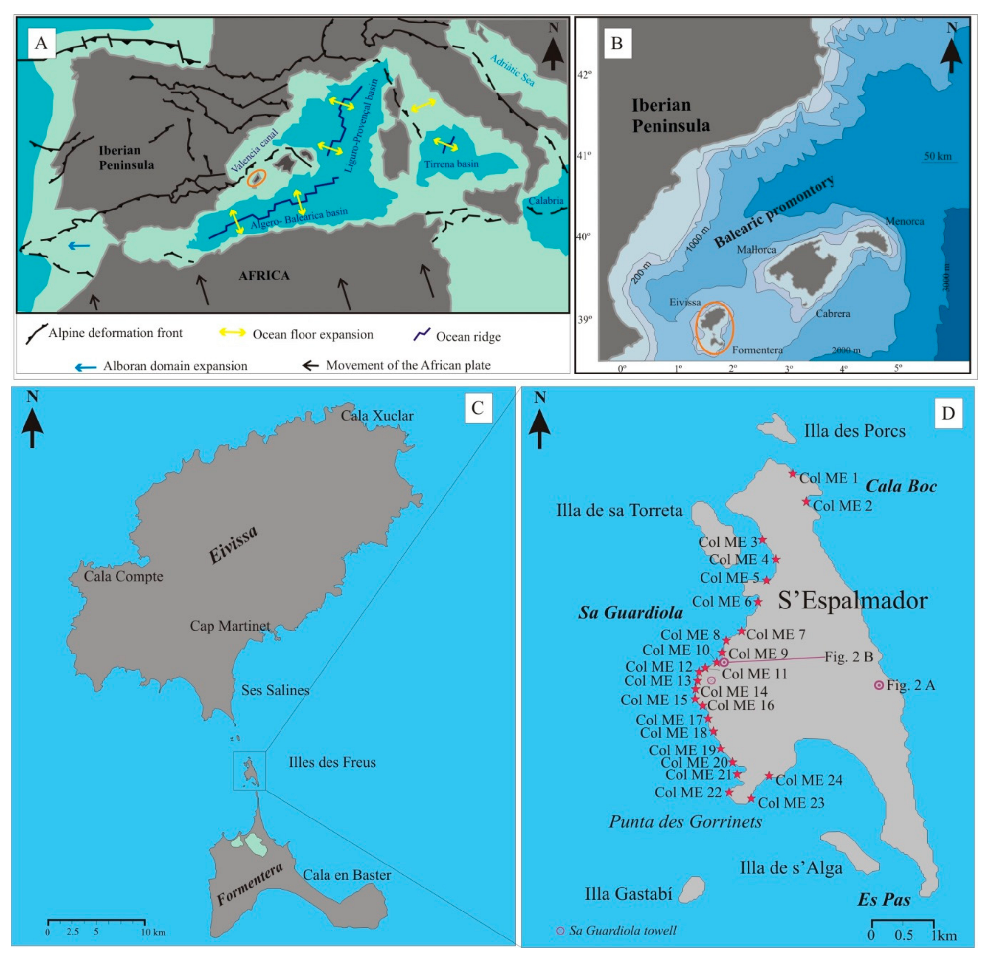
2. Geological Setting
3. Methods
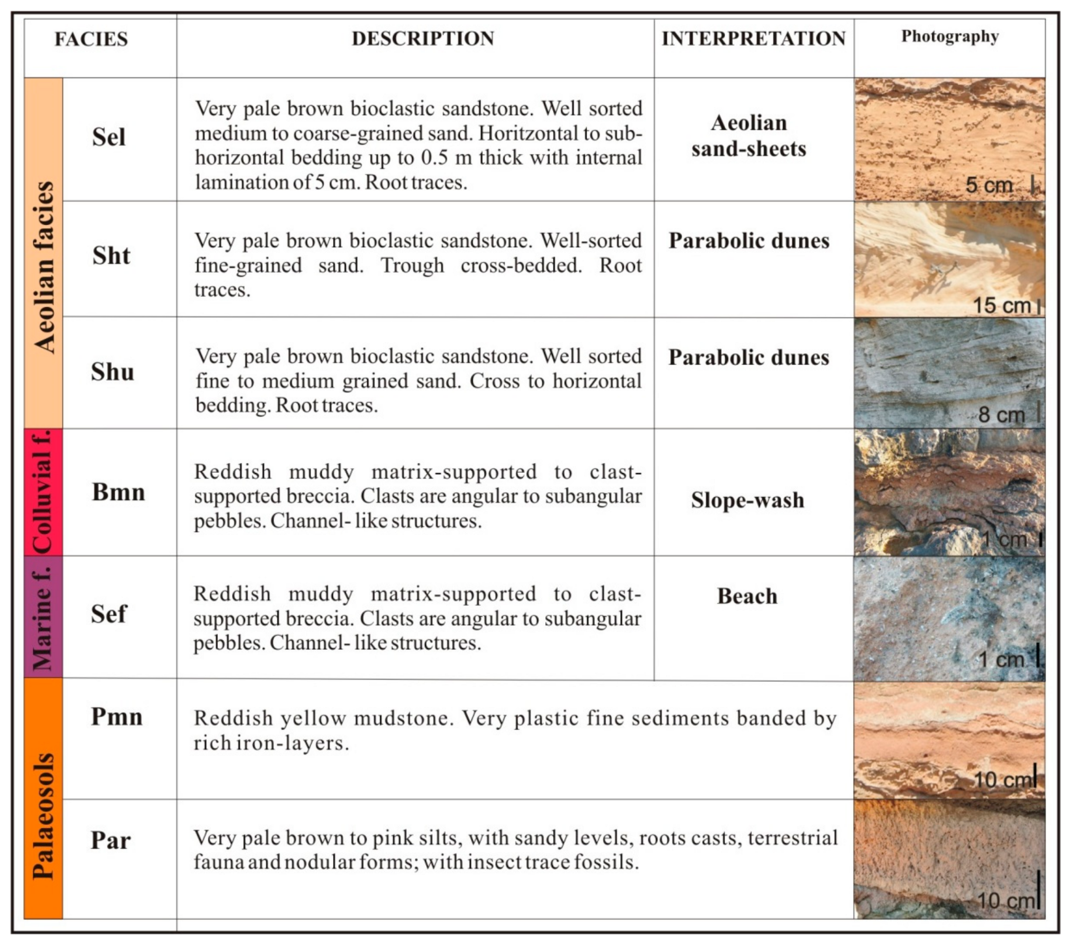
Facies Analysis
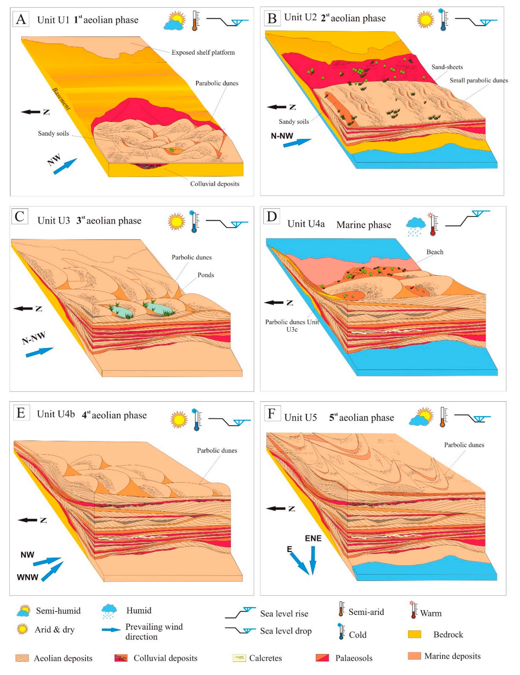
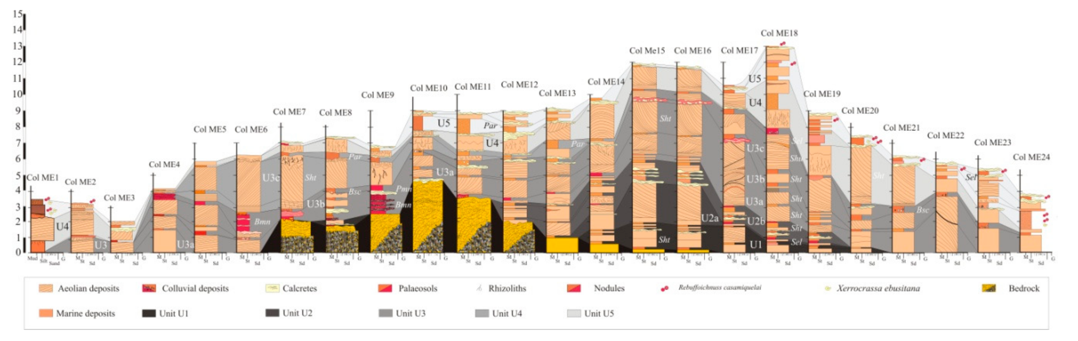
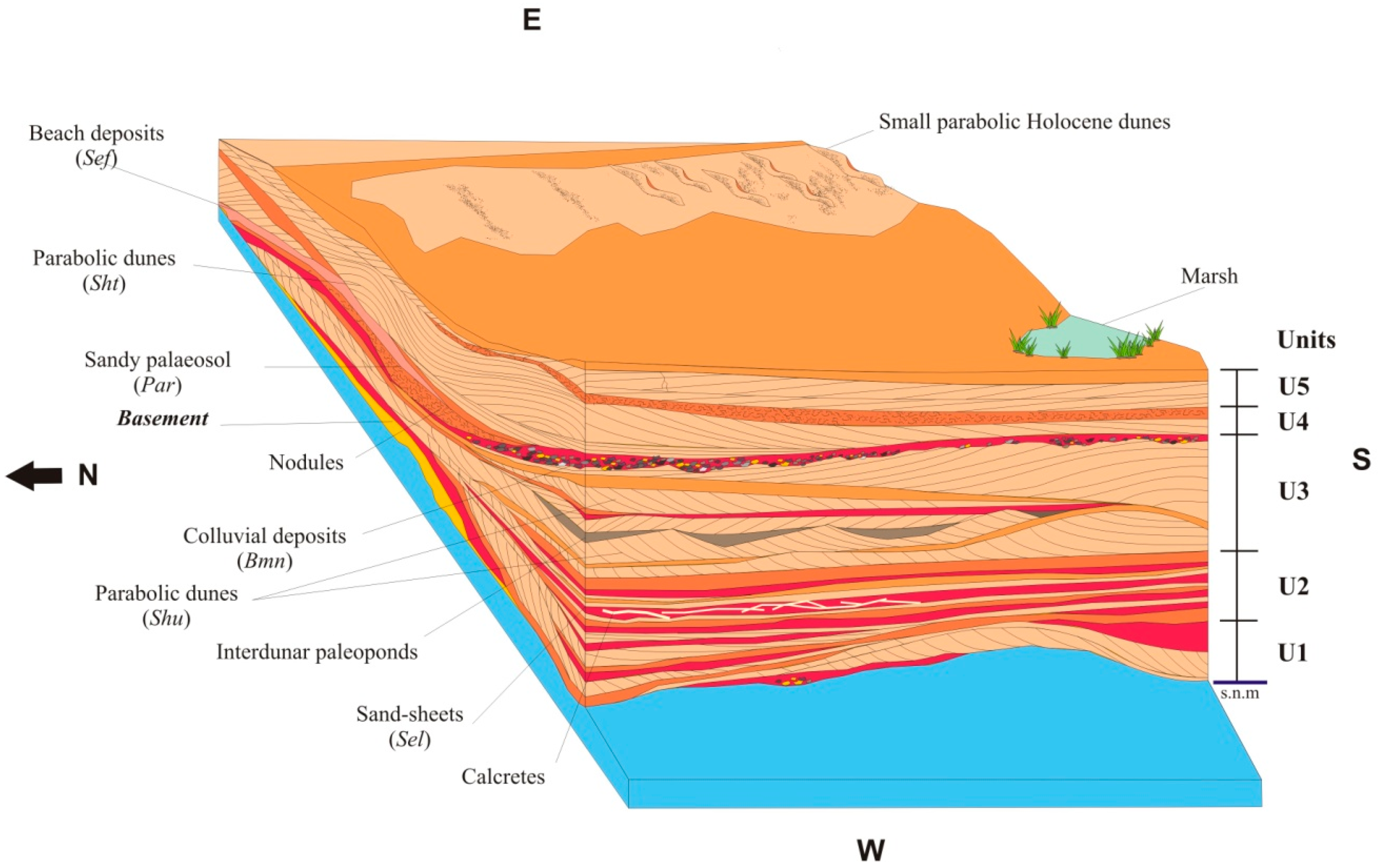
4. Results and Discussion
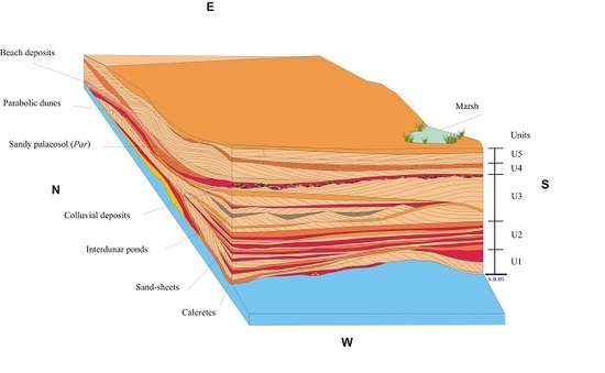
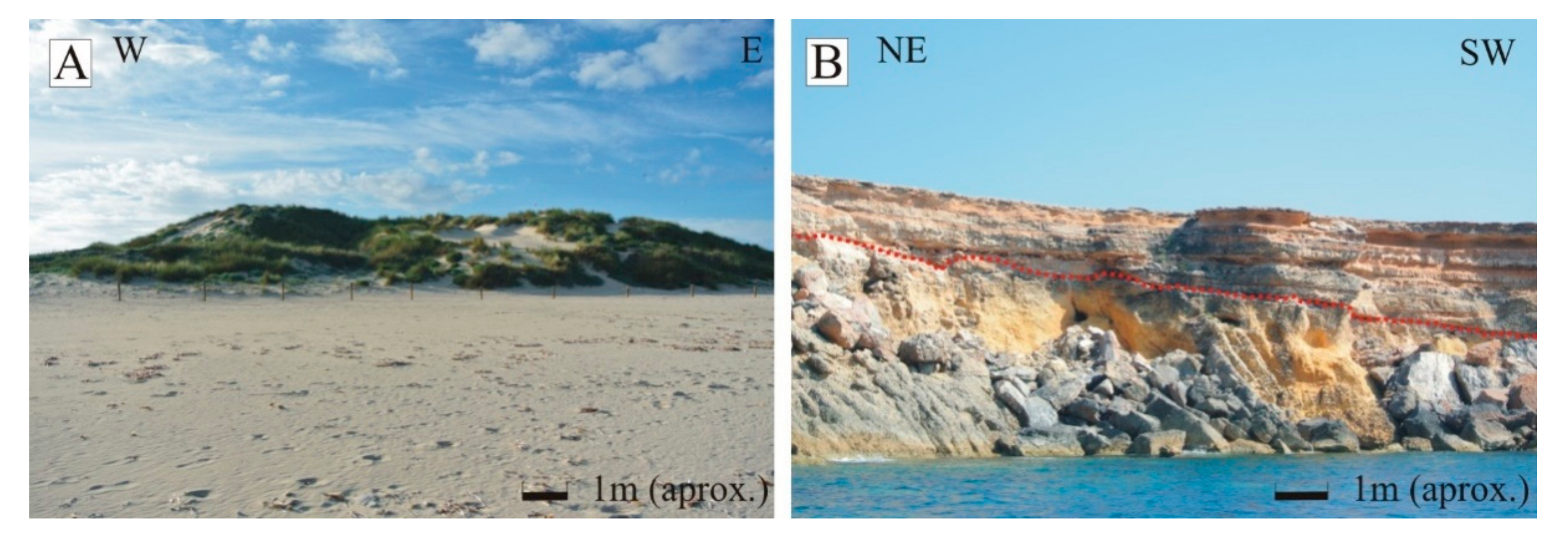
4.1. Sedimentary Facies and Palaeosol Description
4.2. Aeolian Facies Association
4.3. Colluvial-Alluvial Facies Association
4.4. Shallow-Marine Facies Association
4.5. Palaeosols
5. Discussion
6. Conclusions
Author Contributions
Funding
Acknowledgments
Conflicts of Interest
References
- Belknap, D.F. Encyclopædia Britannica. Quaternary. 2017. Available online: https://www.britannica.com/science/Quaternary (accessed on 26 March 2019).
- Onac, B.P.; Ginés, A.; Ginés, J.; Fornós, J.J.; Dorale, J.A. Late Quaternary Sea-level history: Aspeleothem perspective. In Mallorca: A Benchmark for Quaternary Studies; Ginés, A., Ginés, J., Gómez-Pujol, L., Onac, B.P., Fornós, J.J., Eds.; Mon. Soc. Hist. Nat. Balears: Palma, Spain, 2012; Volume 18, pp. 147–162. [Google Scholar]
- Mckee, E.D.; Ward, W.C. Eolian environments. In Carbonate Depositional Environments; Scholle, P.A., Bebont, D.G., Moore, C.H., Eds.; AAPG 1983; Memoir No. 33; AAPG: Tulsa, OK, USA, 1983; Volume 33, pp. 131–170. [Google Scholar]
- El-Asmar, H. Aeolianite sedimentation along the northwestern coast of Egipt: Evidence for middle to late quaternary aridity. Quat. Sci. Rev. 1994, 13, 699–708. [Google Scholar]
- Clemmensen, L.B.; Fornós, J.J.; Rodríguez-Perea, A. Morphology and architecture of a late-Pleistocene cliff-front dune, Mallorca, Western Mediterranean. Terra Nova 1997, 9, 251–254. [Google Scholar]
- Clemmensen, L.B.; Lisborg, T.; Fornós, J.J.; Bromley, R.G. Cliff-front aeolian and colluvial deposits, Mallorca, Western Mediterranean: A record of climatic and environmental change during the last glacial period. Bull. Geol. Soc. Denmark 2001, 48, 217–232. [Google Scholar]
- Rose, J.; Meng, X.; Watson, C. Palaeoclimate and palaeoenvironmental responses in the western Mediterranean over the last 140 ka: Evidence from Mallorca, Spain. J. Geol. Soc. 1999, 156, 435–448. [Google Scholar]
- Price, D.M.; Brooke, B.P.; Woodroffe, C.D. Thermoluminescence dating on aeolianites from Lord Howseisland and south-western Australian. Quat. Sci. Rev. 2001, 20, 841–846. [Google Scholar] [CrossRef]
- Zazo, C.; Goy, J.L.; Dabrio, C.J.; Bardají, T.; Hillaire-Marcel, C.; Ghaleb, B.; González-Delgado, J.A.; Soler, V. Pleistocene raised marine terraces of the Spanish Mediterranean and Atlantic coasts: Records of coastal uplift, sea-level highstands and climate changes. Mar. Geology 2003, 194, 103–133. [Google Scholar] [CrossRef]
- Frechen, M.; Neber, A.; Tsatskin, A.; Boenigk, W.; Ronen, A. Chronology of Pleistocene sedimentary cycles in the Carmel coastal plain of Israel. Quat. Int. 2004, 121, 1–52. [Google Scholar] [CrossRef]
- Nielsen, K.A.; Clemmensen, L.B.; Fornós, J.J. Middle Pleistocene magnetostratigraphy and susceptibility stratigraphy: Data from a carbonate aeolian system, Mallorca, Western Mediterranean. Quat. Sci. Rev. 2004, 23, 1733–1756. [Google Scholar]
- Rodríguez-Vidal, J.; Caceres, L.M.; Finlayson, J.C.; Gracia, F.J.; Martíniez-Aguirre, A. Neotectonics and shoreline history of the Rock of Gibraltar, southern Iberia. Quat. Sci. Rev. 2004, 23, 2017–2029. [Google Scholar] [CrossRef]
- Munyikawa, K. Synchrony of southern hemisphere Late Pleistocene aridepisodes: A review of luminescence chronologies from arid Aeolian landscape south of equator. Quat. Sci. Rev. 2005, 24, 2555–2583. [Google Scholar] [CrossRef]
- Galili, E.; Zviely, D.; Ronen, A.; Mienis, H.K. Beach deposits of MIS 5e high sea stand as indicators for tectonic. Quat. Sci. Rev. 2007, 26, 2544–2557. [Google Scholar] [CrossRef]
- Andreucci, S.; Clemmensen, L.B.; Martini, A.; Pascucci, V. Late Pleistocene Coastal Systems of North western Sardinia (Italy): Sandy Beaches, Coastal Dunes and Alluvial Fans. In Field Trip 1. 27th IAS Meeting. Proceedings of the International Meeting of Sedimentology, Alghero, Italy, 28–30 September 2012; SEQS: Bergün, Switzerland, 2012; Volume 216, pp. 104–116. [Google Scholar]
- Andreucci, S.; Pascucci, V.; Murray, A.S.; Clemmensen, L.B. Late Pleistocene coastal evolution of San Giovanni di Sinis, west Sardinia (Western Mediterranean). Sediment. Geol. 2009, 216, 104–116. [Google Scholar] [CrossRef]
- Andreucci, S.; Clemmensen, L.B.; Murray, A.; Pascucci, V. Middle Late Pleistocene coastal deposits of Alghero, northwestern Sardinia (Italy): Chronology and evolution. Quat. Int. 2010, 222, 3–16. [Google Scholar] [CrossRef]
- Andreucci, S.; Panzeri, L.; Martini, P.; Maspero, F.; Martini, M.; Pascucci, V. Evolution and architecture of a West Mediterranean Upper Pleistocene to Holocene coastal apron-fan system. Sedimentology 2014, 61, 333–361. [Google Scholar] [CrossRef]
- Fornós, J.J.; Clemmensen, L.B.; Gómez-Pujol, L.; Murray, A. Late Pleistocene carbonate aeolianites on Mallorca, Western Mediterranean: A luminescence chronology. Quat. Sci. Rev. 2009, 28, 2697–2709. [Google Scholar] [CrossRef]
- Pavelic, D.; Kovacic, M.; Vlahovic, I.; Wacha, L. Pleistocene calcareous Aeolian alluvial deposition in a steep relief karstic coastal belt (island of Hvar, eastern Adriatic, Croatia). Sediment. Geol. 2011, 239, 64–79. [Google Scholar] [CrossRef]
- Pappalardo, M.; Chelli, A.; Ciampalini, A.; Rellini, I.; Biagioni, F.; Brückner, H.; Fülling, A.; Firpo, M. Evolution of an Upper Pleistocene aeolianite in the northern Mediterranean (Liguria, NW Italy). Italy J. Geosci. 2013, 132, 290–303. [Google Scholar]
- Pomar, F.; Fornós, J.J.; Gómez-Pujol, L.; del Valle, L. Las eolianitas cuaternarias de Menorca y los depósitos asociados. In Geomorfología Litoral de Menorca: Dinámica, Evolución y Prácticas de Gestión; Gómez-Pujol, L., Pons, G.X., Eds.; Mon. Soc. Hist. Nat. Balears: Palma, Spain, 2017; Volume 25, pp. 111–136. [Google Scholar]
- Pomar, F.; del Valle, L.; Fornós, J.J.; Gómez-Pujol, L. Late Pleistocene dune-sourced alluvial fans in coastal settings: Sedimentary facies and related processes (Mallorca, Western Mediterranean). Sediment. Geol. 2018, 367, 48–68. [Google Scholar] [CrossRef]
- Rowell, A.; Thomas, D.; Bailey, R.; Stone, A.; Garzanti, E.; Padoan, M. Controls on sand ramp formation in southern Namibia. Earth Surf. Process. Landf. 2018, 43, 150–171. [Google Scholar] [CrossRef]
- Hearty, P.J. New data on the Pleistocene of Mallorca. Quat. Sci. Rev. 1987, 6, 245–257. [Google Scholar] [CrossRef]
- Bateman, M.D.; Bryant, R.G.; Foster, I.D.L.; Livignstone, I.; Parson, A.J. On the formation of sandramps: A case study from Mojave Desert. Geomorphology 2012, 161–162, 93–109. [Google Scholar] [CrossRef]
- Bateman, M.D.; Murton, J.B. The chronostratigraphy of the Late Glacial and Periglacial Aeolian Activity in the Tuktoyaktuk Coastlands, NWT, Canada. Quat. Sci. Rev. 2006, 25, 2552–2568. [Google Scholar] [CrossRef]
- Chase, B.; Thomas, D.S.G.; Bateman, M.D.; Meadows, M.E. Late Quaternary dune development along the western margin of South Africa and its relationship to paleoclimatic changes inferred from the marine record. PAGES News 2007, 15, 26–27. [Google Scholar] [CrossRef]
- Hearty, P.J.; O’Leary, M.J. Carbonate eolianites, quartz sands, and Quaternary sea-level cycles, Western Australia: A chronostratigraphic approach Quaternary. Geochronology 2008, 3, 26–55. [Google Scholar] [CrossRef]
- Del Valle, L.; Gómez-Pujol, L.; Fornós, J.J.; Timar-Gabor, A.; Anechitei-Deacu, V.; Pomar, F. Middle to Late Pleistocene dunefields in rocky coast settings at Cala Xuclar (Eivissa, Western Mediterranean): Recognition, architecture and luminescence chronology. Quat. Int. 2016, 407, 4–13. [Google Scholar] [CrossRef]
- Just, J.; Hübscher, C.; Betzler, C.; Lüdmann, T.; Reicherter, K. Erosion of continental margins in the Western Mediterranean due to sea-level stagnancy during the Messinian salinity crisis. Geo-Marine Lett. 2011, 31, 51–64. [Google Scholar] [CrossRef]
- Sàbat, F.; Gelabert, B.; Rodríguez-Perea, A.; Jiménez, J. Geological structure and evolution of Majorca: Implications for the origin of the western Mediterranean. Tectonophysics 2011, 510, 217–238. [Google Scholar] [CrossRef]
- Nolan, H. Structure géologique d’ensemble de l’archipel Baléare. Bull. Soc. Geol. France 1895, 3, 76–91. [Google Scholar]
- Butzer, K.W.; Cuerda, J. Nuevos yacimientos marinos cuaternarios de las Baleares. Notas y comns. Instituto Geológico y minero de España 1962, 67, 25–70. [Google Scholar]
- Cuerda, J. A contribution to the knowledge of Pleistocene coastal profiles in the Pityussic Islands. In Biogeography and Ecology of the Pityussic Islands; Kuhbièr, K., Alcover, J.A., Guereau d’Arellano Tur, C., Eds.; DR W. Junk Publishers LA HAGUE: Boston, MA, USA, 1984; p. 703. [Google Scholar]
- Tucker, M. Techniques in Sedimentology. Blackwell Scientific Publications: Oxford, UK, 1988; p. 394. [Google Scholar]
- Downs, R.T.; Hall-Wallace, M. The American Mineralogist Crystal structure data base. Am. Mineral. 2003, 88, 247–250. [Google Scholar]
- Gale, S.J.; Hoare, P.G. Quaternary Sediments; Halsted Press: New York, NJ, USA, 1991; p. 323. [Google Scholar]
- Munsell Color (Firm). Munsell Soil Color Charts: With Genuine Munsell Color Chips. Grand Rapids, MI: Munsell Color, 2010. Available online: https://search.library.wisc.edu/catalog/9910109259802121/cite (accessed on 17 November 2018).
- Pons, G.X.; Del Valle, L.; Vicens, D.; Mir-Gual, M. Yacimientos Paleontológicos del Cuaternario en el Litoral de les Islas Pitiusas: Aproximación al inventario de las islas de Eivissa y Formentera. In Proceedings of the XII Reunió Nacional de la Comissió de Patrimoni Geològic de la Societat Geológica de España, Menorca, Spain, 6 to 10 of June; Del Valle, L., Duque-Macias, J., Giménez, A., Hilario, M., Monge-Ganuzas, J., Rodríguez, A., Eds.; Patrimonio Geológico, gestionando la parte abiótica del patrimonio natural, Cuadernos del Museo Geominero, Instituto Geológico y Minero de España: Menorca, Spain, 2017; Volume 21, pp. 83–88. [Google Scholar]
- Del Valle, L.; Vicens, D.; Pomar, F.; Pons, G.X. El registre paleontològic de l’illa d’Eivissa a jaciments litorals pleistocens. Boll. Soc. Hist. Nat. Balears 2017, 60, 90–104. [Google Scholar]
- Muhs, D.R.; Budahn, J.; Avila, A.; Skipp, G.; Freeman, J.; Patternson, D. The role of African dust in the formation of Quaternary soils on Mallorca, Spain and implications for the genesis of Red Mediterranean soils. Quat. Sci. Rev. 2010, 29, 2518–2543. [Google Scholar] [CrossRef]
- Wagner, S.; Eckmeier, E.; Skowronek, A.; Günster, N. Quaternary paleosols and sediments on the Balearic Islands as indicators of climate changes. Catena 2014, 112, 112–124. [Google Scholar] [CrossRef]
- Flügel, E. Microfacies of Carbonate Rocks. Analysis, Interpretation and Application; Springer: Berlin, Germany, 2014; p. 976. [Google Scholar]
- Allen, J.R.L.; Brandt, U.; Brauer, A.; Hubberten, H.W.; Huntley, B.; Keller, J.; Kraml, M.; Mackensen, A.; Mingram, J.; Negendank, J.F.W. Rapid environmental changes in southern Europe during the last glacial period. Nature 1999, 400, 740–743. [Google Scholar] [CrossRef]


© 2019 by the authors. Licensee MDPI, Basel, Switzerland. This article is an open access article distributed under the terms and conditions of the Creative Commons Attribution (CC BY) license (http://creativecommons.org/licenses/by/4.0/).
Share and Cite
del Valle Villalonga, L.; Timar-Gabor, A.; Fornós, J.J. Geomorphological Processes and Environmental Interpretation at Espalmador islet (Western Mediterranean). J. Mar. Sci. Eng. 2019, 7, 144. https://doi.org/10.3390/jmse7050144
del Valle Villalonga L, Timar-Gabor A, Fornós JJ. Geomorphological Processes and Environmental Interpretation at Espalmador islet (Western Mediterranean). Journal of Marine Science and Engineering. 2019; 7(5):144. https://doi.org/10.3390/jmse7050144
Chicago/Turabian Styledel Valle Villalonga, Laura, Alida Timar-Gabor, and Joan J. Fornós. 2019. "Geomorphological Processes and Environmental Interpretation at Espalmador islet (Western Mediterranean)" Journal of Marine Science and Engineering 7, no. 5: 144. https://doi.org/10.3390/jmse7050144
APA Styledel Valle Villalonga, L., Timar-Gabor, A., & Fornós, J. J. (2019). Geomorphological Processes and Environmental Interpretation at Espalmador islet (Western Mediterranean). Journal of Marine Science and Engineering, 7(5), 144. https://doi.org/10.3390/jmse7050144