
Marine Habitat Mapping Incorporating Both Derivatives of LiDAR Data and Hydrodynamic Conditions

Abstract
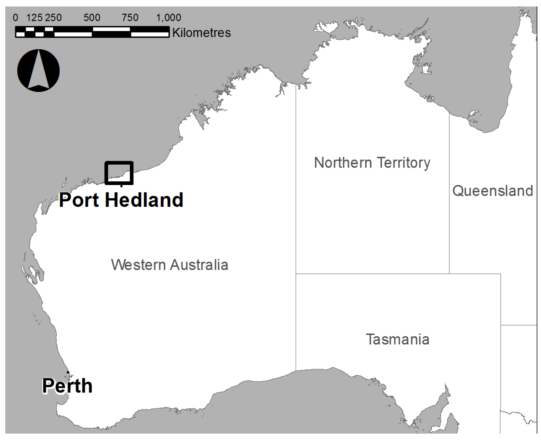
:1. Introduction
1.1. Bathymetric Dataset from LiDAR
1.2. Influence of Hydrodynamics on Marine Habitat
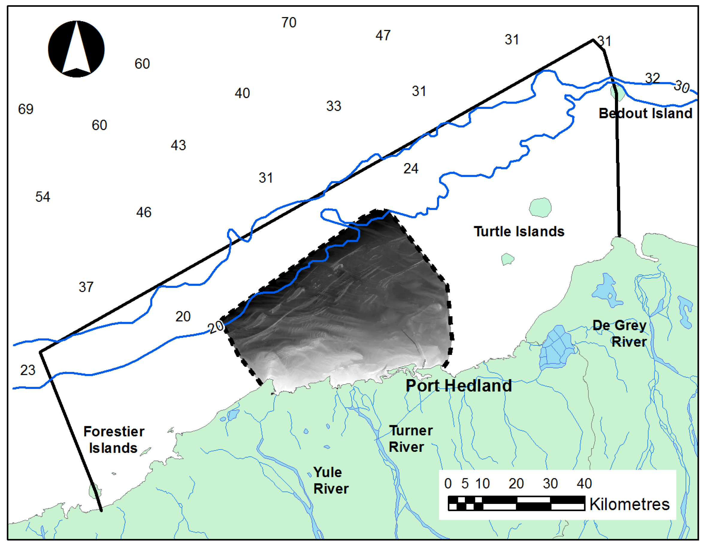
2. Experimental Section
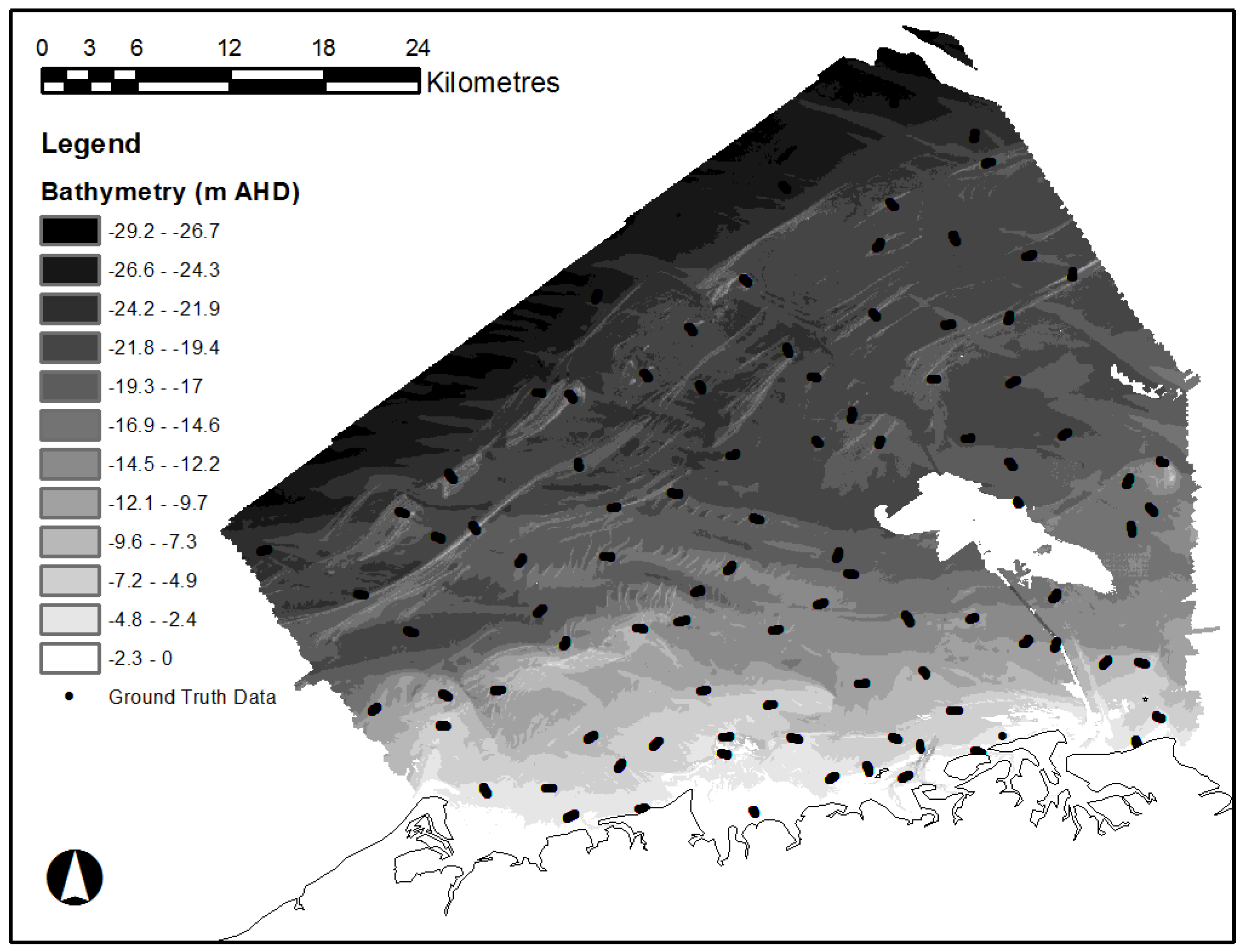
2.1. LiDAR Bathymetry
2.2. Derivatives of LiDAR Data

| Primary Derivative | Secondary Derivative | Definition | Potential Habitat Influence |
|---|---|---|---|
| Bathymetry | Distance (in metres) above a height datum (e.g., The Australian Height Datum, AHD). | Pressure associations and light penetration. | |
| Slope | Maximum change in elevation between each cell and cells in its analysis neighbourhood (in degrees from horizontal). | Susceptibility to sediment accumulation; exposure to waves and currents. | |
| Slope Length | Slope length is the distance from bathymetric ridges to bottom of the slope face. | Exposure to wave energy and currents. | |
| Aspect | Azimuthal bearing of steepest slope, separated into 8 directional components (N, NE, E, SE, S, SW, W, NW). | Exposure to wave energy and currents. | |
| Curvature | Profile Curvature | The curvature of the surface in the steepest down-slope direction. It describes the rate of change of slope along a profile. | Exposure to currents; rock type. |
| Bathymetric Position Index (BPI) | The variation among cells within a specified radius or annulus; it may be calculated at a variety of user-defined scales so as to capture local and broad-scale variations in bathymetric position. Radius scales are 15/30 m, 25/50 m, 50/100 m, 75/150 m, 100/200 m. | Susceptibility to sediment accumulation; exposure; potential reef dwelling species habitat. | |
| Terrain | Bathymetric Ruggedness Index | The BRI value is calculated by comparing a central pixel with its neighbours, taking the absolute values of the differences, and averaging the result. | Defines potential reef dwelling species habitat. |
| Rugosity (surface ratio) | The rugosity is the ratio of the surface area to the planar area across the neighbourhood of the central pixel (rugosity = surface area of 3 × 3 neighbourhood / planar area of 3 × 3 neighbourhood). | Defines potential reef dwelling species habitat. | |
| Valley Bottom Flatness | Delineates flat areas in valley bottoms. High values indicate areas that are more likely valley bottoms. | Susceptibility to sediment accumulation. | |
| Ridge Top Flatness | Delineates flat areas on ridge tops. High values indicate areas that are more likely ridge tops. | Exposure to wave energy and currents. |
2.3. Hydrodynamic Modelling
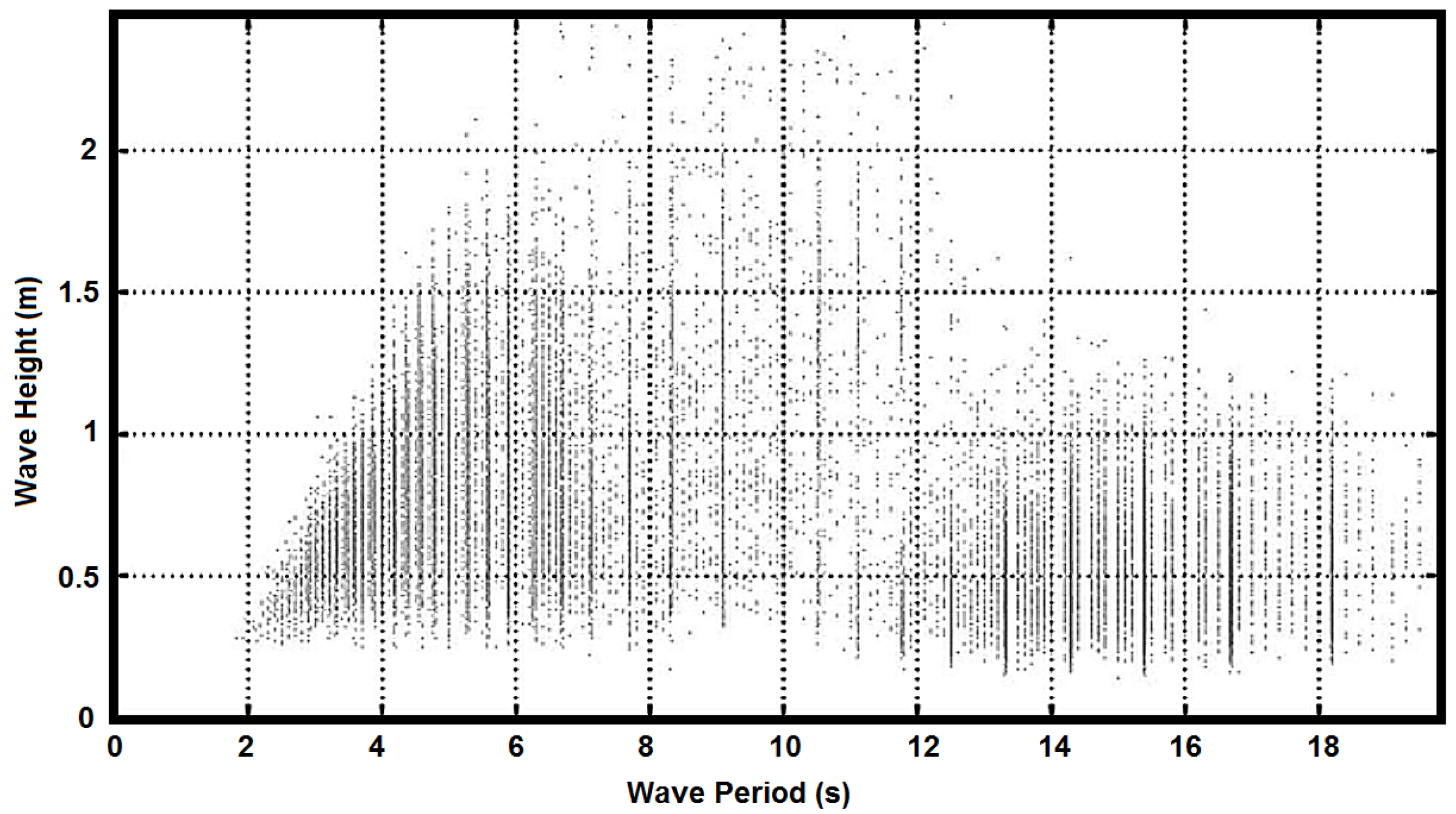
2.4. Waves

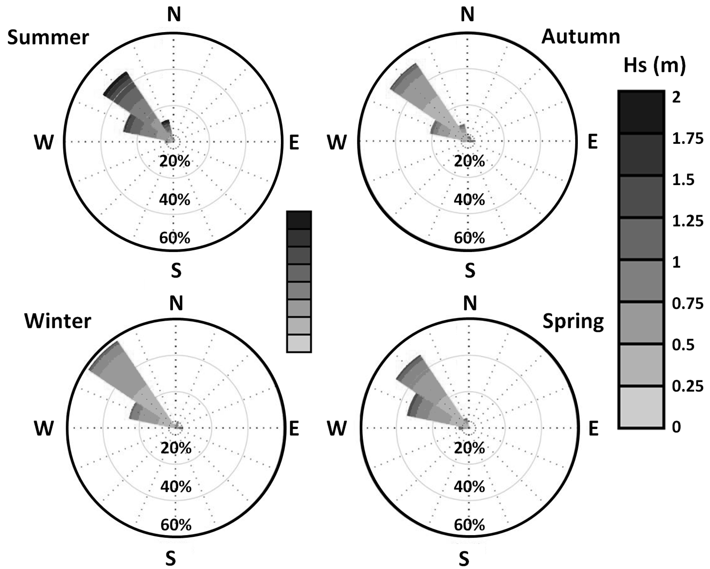
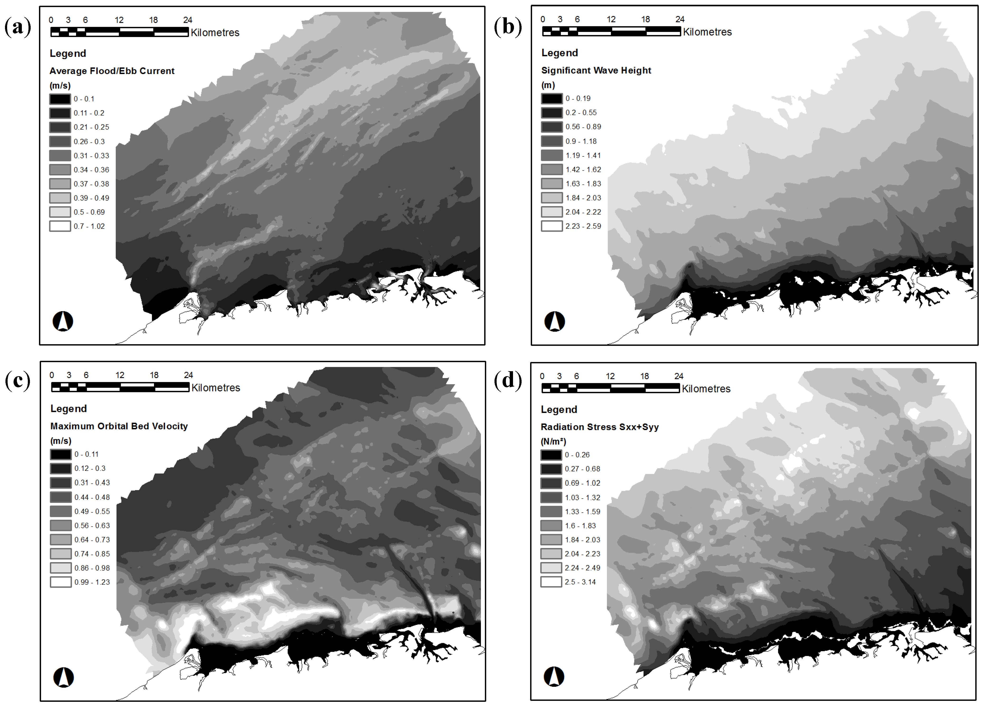
2.5. Tidal Currents
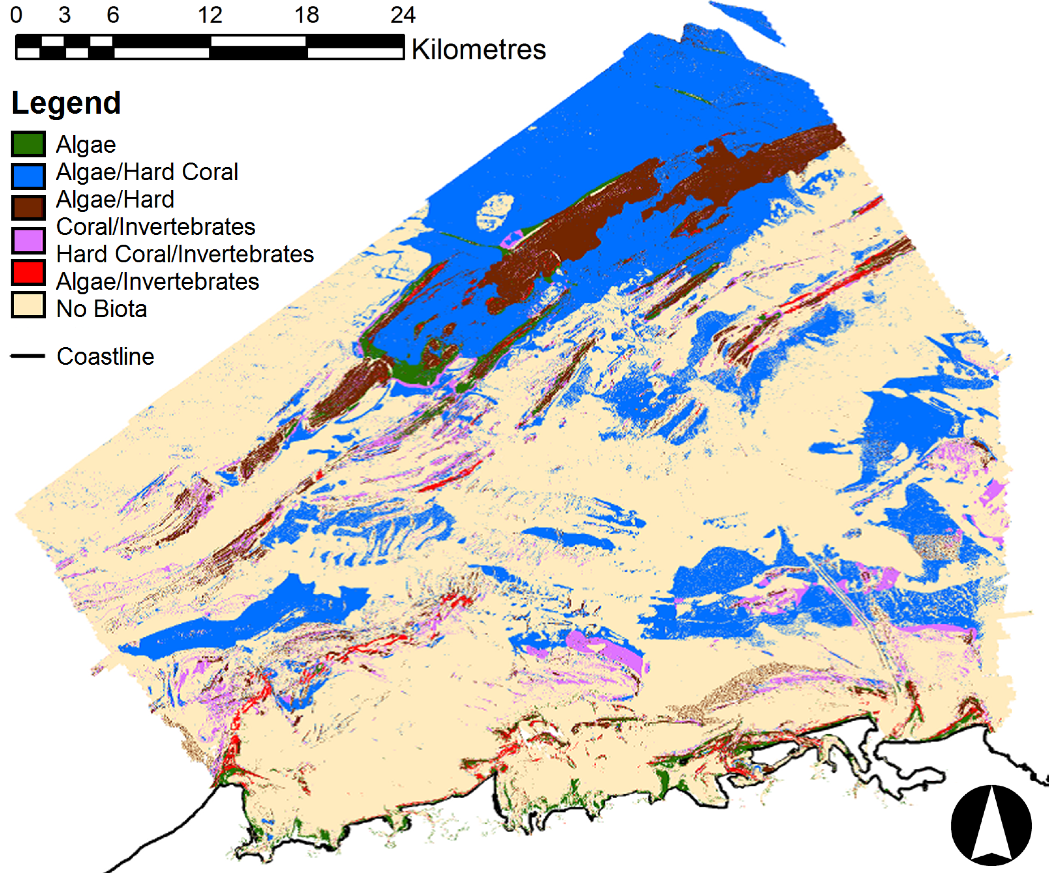
2.6. Habitat Categories
| Habitat Category | Description |
|---|---|
| Seagrass | Seagrasses present (Halophila, Halodule). |
| Algae | Macro-algae (Sargassum, Dictyota, Padina, Lobophora, Caulerpa, Halimeda) and visible turf algae. |
| Invertebrates | Filter feeders (sponges, ascidians, gorgonians, soft corals, sea whips, crinoids, hydroids, bryozoans). |
| Algae/Hard Coral | Presence of algae and hard corals (Turbinaria, Plesiastrea versipora, Favia, Favites, Porites, Goniopora, Pseudosiderastrea tayami and Trachyphyllia geoffroyi). |
| Algae/Hard Coral/Invertebrates | Presence of a mosaic of algae and coral species as well as other undifferentiated invertebrates. |
| Hard coral/Invertebrates | Presence of a mosaic of coral species as well as other undifferentiated invertebrates. |
| Algae/Invertebrates | Presence of algae as well as other undifferentiated invertebrates |
| No Epibenthos Evident | Bare sediment with no apparent epifauna (typically sand or gravely sand). |
2.7. Habitat Classifications
2.8. Ground Truthing Program
| Pixel Value | Habitat Category | Pixels of Training Data, n | Pixels of Validation Data |
|---|---|---|---|
| 1 | Seagrass | 1 | 0 |
| 2 | Algae | 193 | 17 |
| 3 | Invertebrates | 1666 | 180 |
| 4 | Algae/Hard Coral | 9 | 0 |
| 5 | Algae/Hard Coral/Invertebrates | 1787 | 208 |
| 6 | Hard Coral/Invertebrates | 654 | 62 |
| 7 | Algae/Invertebrates | 356 | 42 |
| 8 | Epibenthos Evident | 5825 | 653 |
2.9. Habitat Mapping
2.10. Error Assessment
3. Results and Discussion

| Classification | Type | Area (ha) | % of Survey Area |
|---|---|---|---|
| Algae | BPPH * | 3629.28 | 1.76 |
| Invertebrates | BPPH | 48458.04 | 23.47 |
| Algae/Invertebrates ** | BPPH Mosaic | 1831.55 | 0.89 |
| Algae/Hard Coral/Invertebrates ** | BPPH Mosaic | 12863.25 | 5.52 |
| Hard Coral/Invertebrates ** | BPPH Mosaic | 7390.21 | 3.58 |
| No Epibenthos Evident | Non-BPPH (bare sediment) *** | 132337.30 | 64.08 |
| Total | N/A | 206,509.62 | 100 |
Analysis of Accuracy
| Class | Algae | Invert | Algae/Invert | Algae/Hard Coral/Invert | Hard Coral/Invert | No Epibenthos Evident | Total |
|---|---|---|---|---|---|---|---|
| Algae | 15 | 0 | 0 | 1 | 0 | 1 | 17 |
| Invertebrates | 0 | 179 | 0 | 0 | 0 | 1 | 180 |
| Algae/Invert | 1 | 0 | 37 | 3 | 0 | 1 | 42 |
| Algae/Hard Coral/Invert | 1 | 0 | 4 | 200 | 2 | 1 | 208 |
| Hard Coral/Invert | 0 | 0 | 0 | 0 | 58 | 4 | 62 |
| No Epibenthos Evident | 0 | 3 | 1 | 1 | 3 | 645 | 653 |
| Total | 17 | 182 | 42 | 205 | 63 | 653 | 1162 |
| Missing Hydrodynamic Data | Accuracy (%) | Kappa Coefficient |
|---|---|---|
| Significant Wave Height | 94.6 | 0.9138 |
| Current | 97.9 | 0.9661 |
| Radiation Stress | 93.4 | 0.8948 |
| Orbital Velocity | 94.9 | 0.9199 |
4. Conclusions
Author Contributions
Conflicts of Interest
References
- Diaz, R.J.; Solan, M.; Valente, R.M. A review of approaches for classifying benthic habitats and evaluating habitat quality. J. Environ. Manag. 2004, 73, 165–181. [Google Scholar] [CrossRef] [PubMed]
- McArthur, M.A.; Brooke, B.P.; Przeslawski, R.; Ryan, D.A.; Lucieer, V.L.; Nichol, S.; McCallum, A.W.; Mellin, C.; Cresswell, I.D.; Radke, L.C. On the use of abiotic surrogates to describe marine benthic biodiversity. Estuar. Coast. Shelf Sci. 2010, 88, 21–32. [Google Scholar] [CrossRef]
- Vierling, K.T.; Vierling, L.A.; Gould, W.A.; Martinuzzi, S.; Clawges, R.M. Lidar: Shedding new light on habitat characterization and modeling. Front. Ecol. Environ. 2008, 6, 90–98. [Google Scholar] [CrossRef]
- Rattray, A.; Ierodiaconou, D.; Womersley, T. Wave exposure as a predictor of benthic habitat distribution on high energy temperate reefs. Front. Mar. Sci. 2015, 2, 1–14. [Google Scholar] [CrossRef]
- Huang, Z.; Brooke, B.P.; Harris, P.T. A new approach to mapping marine benthic habitats using physical environmental data. Cont. Shelf Res. 2011, 31, S4–S16. [Google Scholar] [CrossRef]
- Banic, J.; Cunningham, G. Airborne Laser Bathymetry: A tool for the Next Millennium; Optech Inc.: Toronto, Ontario, Canada, 1998; pp. 75–80. [Google Scholar]
- Guenther, G.C. Airborne Laser Hydrography: System Design and Performance Factors; NOAA professional paper series, National Ocean Services 1; National Oceanic and Atmospheric Administration: Rockville, MD, USA.
- Smith, R.A.; Irish, J.L.; Smith, M.Q. Airborne Lidar and airborne hyperspectral imagery: A fusion of two proven sensors for improved hydrographic surveying. In Proceedings of Canadian Hydrographic Conference, Montreal, Canada, 16–18 May 2000.
- Guenther, G.C.; Cunningham, A.G.; Larocque, P.E.; Reid, D.J.; Service, N.O.; Highway, E.; Spring, S. Meeting the Accuracy Challenge in Airborne Lidar Bathymetry. In Proceedings of EARSeL-SIG-Workshop LIDAR, Dresden, FRG, 16–17 June 2000.
- Finkl, C.W.; Benedet, L.; Andrews, J.L. Laser Airborne Depth Sounder (LADS): A New Bathymetric Survey Technique in the Service of Coastal Engineering, Environmental Studies, and Coastal Zone Management. In Proceedings of the 17th Annual National Conference on Beach Preservation Technology, Lake Buena Vista, FL, USA, 11–13 February 2004.
- Eyre, B.D.; Maher, D. Mapping ecosystem processes and function across shallow seascapes. Cont. Shelf Res. 2011, 31, S162–S172. [Google Scholar] [CrossRef]
- Ward, T.J.; Vanderklift, M.A.; Nicholls, A.O.; Kenchington, R.A. Selecting marine reserves using habitats and species assemblages as surrogates for biological diversity. Ecol. Appl. 1999, 9, 691–698. [Google Scholar] [CrossRef]
- Hatcher, B.G.; Johannes, R.E.; Robertson, A.I. Review of research relevant to the conservation of shallow tropical marine ecosystems. Oceanogr. Mar. Biol. Annu. Rev. 1989, 27, 337–414. [Google Scholar]
- Ryan, D.A.; Brooke, B.P.; Collins, L.B.; Spooner, M.I.; Siwabessy, P.J.W. Formation, morphology and preservation of high-energy carbonate lithofacies: Evolution of the cool-water Recherche Archipelago inner shelf, south-western Australia. Sediment. Geol. 2008, 207, 41–55. [Google Scholar] [CrossRef]
- Ryan, D.A.; Brooke, B.P.; Collins, L.B.; Kendrick, G.A.; Baxter, K.J.; Bickers, A.N.; Siwabessy, P.J.W.; Pattiaratchi, C.B. The influence of geomorphology and sedimentary processes on shallow-water benthic habitat distribution: Esperance Bay, Western Australia. Estuar. Coast. Shelf Sci. 2007, 72, 379–386. [Google Scholar] [CrossRef]
- Marrack, E.C. The Relationship Between Water Motion and Living Rhodolith Beds in the Southwestern Gulf of California, Mexico. Palaios 1999, 14, 159–171. [Google Scholar] [CrossRef]
- Hills, D.J.; Jones, B. Peyssonnelid rhodoliths from the Late Pleistocene Ironshore Formation, Grand Cayman, British West Indies. Palaios 2000, 15, 212–224. [Google Scholar] [CrossRef]
- Harris, P.T.; Baker, E.K. Geohab Atlas of Seafloor Geomorphic Features and Benthic Habitats: Synthesis and Lessons Learned. In Seafloor Geomorphology as Benthic Habitat; Elsevier: Amsterdam, The Netherlands, 2012; pp. 871–890. [Google Scholar]
- Fugro LADS Mk 3 ALB System; Fugro Lads Corporation: Kidman Park, Australia, 2011; p. 2.
- Cimmery, V. User Guide for SAGA (Version 2.0.5). Available online: http://www.saga-gis.org/en/about/references.html (accessed on 1 July 2012).
- Sørensen, O.L.E.R.; Kofoed-Hansen, H.; Rugbjerg, M.; Sørensen, L.S. Using an Unstructured Finite Volume Technique. In Proceedings of the 29th International Conference on Coastal Engineering, Lisbon, Portugal, 19–24 September 2004.
- Lumsden Point General Cargo Facility: Hydrodynamic Impact Assessment for EIA; WorleyParsons: Port Hedland, Western Australia, 2013; pp. 12–14.
- Lumsden Point General Cargo Facility: Sediment Plume Dispersion Study for EIA; WorleyParsons: Port Hedland, Western Australia, 2013; p. 15.
- EPA Environmental Assessment Guideline 3 (EAG3): Protection of Benthic Primary Producer Habitats in Western Australia’s Marine Environment; Event Personnel Australia: Perth, Australia, 2009; p. 41.
- Mount, R.; Bricher, P.; Newton, J. National Intertidal/Subtidal Benthic Habitat Classification Scheme; National Land and Water Resources Audit: Hobart, Australia, 2007. [Google Scholar]
- SKM Port Hedland Outer Harbour Development Marine Benthic Habitat Survey Report; SKM: Port Hedland, Australia, 2009; pp. 9–11.
- Rattray, A.; Ierodiaconou, D.; Laurenson, L.; Burq, S.; Reston, M. Hydro-acoustic remote sensing of benthic biological communities on the shallow South East Australian continental shelf. Estuar. Coast. Shelf Sci. 2009, 84, 237–245. [Google Scholar] [CrossRef]
- Foody, G.M. Status of land cover classification accuracy assessment. Remote Sens. Environ. 2002, 80, 185–201. [Google Scholar] [CrossRef]
- Jensen, J.R. Introductory Digital Image Processing: A Remote Sensing Perspective, 3rd ed.; Prentice Hall: Upper Saddle River, NJ, USA, 2005; p. 526. [Google Scholar]
- Mather, P.M. Computer Processing of Remotely Sensed Images, an Introduction; John Wiley & Songs Ltd: Chichester, West Sussex, UK, 2004; p. 324. [Google Scholar]
- Langley, P.; Iba, W. Average-case analysis of a nearest neighbour algorithm. In Proceedings of the 13th International Joint Conference on Artificial Intelligence, Chambery, France, 28 August–3 September 1993; pp. 889–894.
- Iocco, L.E.; Wilber, P.; Diaz, R.J.; Clarke, D.G.; Will, R.J. Benthic Habitats for New York/New Jersey Harbor: 1995 Survey of Jamaica, Upper, Newark, Bowrey, and Flushing Bays; NOAA Coastal Services Center: Silver Spring, MD, USA; US Army Corps of Engineers: Washington, DC, USA, 2000. [Google Scholar]
- Mohn, C.; Beckmann, A. Numerical studies on flow amplification at an isolated shelfbreak bank, with application to Porcupine Bank. Cont. Shelf Res. 2002, 22, 1325–1338. [Google Scholar] [CrossRef]
© 2015 by the authors; licensee MDPI, Basel, Switzerland. This article is an open access article distributed under the terms and conditions of the Creative Commons Attribution license ( http://creativecommons.org/licenses/by/4.0/).
Share and Cite
Smith, G.; Yesilnacar, E.; Jiang, J.; Taylor, C. Marine Habitat Mapping Incorporating Both Derivatives of LiDAR Data and Hydrodynamic Conditions. J. Mar. Sci. Eng. 2015, 3, 492-508. https://doi.org/10.3390/jmse3030492
Smith G, Yesilnacar E, Jiang J, Taylor C. Marine Habitat Mapping Incorporating Both Derivatives of LiDAR Data and Hydrodynamic Conditions. Journal of Marine Science and Engineering. 2015; 3(3):492-508. https://doi.org/10.3390/jmse3030492
Chicago/Turabian StyleSmith, Grant, Ertan Yesilnacar, Junsheng Jiang, and Christian Taylor. 2015. "Marine Habitat Mapping Incorporating Both Derivatives of LiDAR Data and Hydrodynamic Conditions" Journal of Marine Science and Engineering 3, no. 3: 492-508. https://doi.org/10.3390/jmse3030492
APA StyleSmith, G., Yesilnacar, E., Jiang, J., & Taylor, C. (2015). Marine Habitat Mapping Incorporating Both Derivatives of LiDAR Data and Hydrodynamic Conditions. Journal of Marine Science and Engineering, 3(3), 492-508. https://doi.org/10.3390/jmse3030492