Article

Differences in Mesozoic–Cenozoic Structural Deformation Between the Northern and Southern Parts of the East China Sea Shelf Basin and Their Dynamic Mechanisms

1
Qingdao Institute of Marine Geology, China Geological Survey, Ministry of Natural Resources, Qingdao 266237, China
2
Laboratory for Marine Mineral Resources, Qingdao Marine Science and Technology Center, Qingdao 266237, China
3
College of Marine Geosciences, Ocean University of China, Qingdao 266100, China
4
College of Earth Science and Engineering, Shandong University of Science and Technology, Qingdao 266590, China
*
Author to whom correspondence should be addressed.
J. Mar. Sci. Eng. 2025, 13(9), 1809; https://doi.org/10.3390/jmse13091809
Submission received: 7 August 2025 / Revised: 12 September 2025 / Accepted: 12 September 2025 / Published: 18 September 2025
(This article belongs to the Section Geological Oceanography)

Abstract

The East China Sea Shelf Basin (ECSSB) and its adjacent areas, as key regions of the ocean–continent transition zone, have been affected by multiple complex plate collisions, subduction, and back-arc tension since the Mesozoic Era. The structural deformation provides a large amount of geological information on the ocean–continent transition zone. There are significant spatiotemporal differences in the structural deformation within the basin. However, the research remains insufficient and understanding is inconsistent, especially regarding the systematic study of the differences and dynamic mechanisms of north–south structural deformation, which is relatively lacking. This study is based on two-dimensional multi-channel deep reflection seismic profiles spanning the southern and northern basin. Through an integrated re-analysis of gravity, magnetic, and OBS data, the deformation characteristics and processes of the Meso-Cenozoic structures in the basin are analyzed. The differences in structural deformation between the southern and northern basin are summarized, and the controlling effects of deep crust–mantle activity and the influencing factors of shallow structural deformation are explored. Based on deep reflection seismic profiles, the structural deformation characteristics of the Yushan–Kume fault are revealed for the first time, and it is proposed that NW faults, represented by the Yushan–Kume fault, have important tuning effects on the north–south structural differential deformation in the ECSSB. The thermal subsidence of the lithosphere is the direct cause of the development of the Mesozoic ECSSB, while the subduction of the Paleo-Pacific plate is one of the important factors contributing to it. The combined effect of the two has led to significant differences between the northern and southern Mesozoic basin. During the Cenozoic Era, the alternating subduction and changes in the direction of subduction of the Pacific Plate led to spatiotemporal differences in structural deformation within the ECSSB. The development of NW faults was a key factor in the differences in structural deformation between the northern and southern basin. The study of structural deformation differences in the ECSSB not only deepens our understanding of the tectonic evolution in the East Asian continental margin region, but also has important significance for the exploration and evaluation of deep hydrocarbon resources in the ECSSB.

1. Introduction

Affected by the crust–mantle and ocean–land interaction, the complex basin formation background, multi-source dynamic mechanisms, diverse basin properties, and differential evolution processes of hydrocarbon basins in Chinese waters have led to significant spatiotemporal differences between basins [1,2,3]. Up to now, there has been considerable controversy among scholars both domestically and internationally regarding our understanding of the tectonic evolution and dynamic mechanisms of the Meso-Cenozoic basins in eastern China [2]. In the past, due to the limitations of geophysical exploration data being of poor quality and insufficient quantity, there were few studies on systematic structural deformation differences in marine basins and a specific lack of differential analyses based on gravity and magnetic data, OBS data, and deep seismic reflection data. Among the marine basins, the East China Sea Shelf Basin (ECSSB) stands as a quintessential example, making in-depth investigation both imperative and timely.
Overall, previous studies of the ECSSB have been extensive and fruitful [4,5,6,7,8], yielding a wealth of significant results and innovative understandings. The ECSSB hosts abundant hydrocarbon resources. Two sets of fault systems, NE-NNE and NW, control the planar distribution of Meso-Cenozoic structures in the basin, forming a pattern of east–west belting and north–south blocking [9]. At the same time, the basin also shows a tectonic evolution process of early northeast belting and late northwest blocking, presenting a Mesozoic tectonic pattern of concave and convex alternation [10]. In addition, long-term active deep fault belts not only play an important controlling role in the north–south block of the basin, but also have a significant impact on the migration and accumulation of oil and gas. However, their dynamic mechanisms lack systematic research.
With the continuous advancement of seismic survey technology in marine areas, multi-channel seismic data can reveal deeper geological structures, and even clearly reveal the seismic reflection characteristics of the Moho. This study aims to use multi-channel deep seismic reflection, gravity magnetic, and OBS data to analyze the structural deformation differences of the southern and northern ECSSB. The focus will be on studying the controlling effect of NW faults (represented by the Yushan–Kume fault) on the differences in deep and shallow structures, and exploring the deep dynamic mechanisms that cause structural differences between the northern and southern ECSSB.

2. Tectonic Setting

The ECSSB is located at the intersection of the Eurasian Plate, Pacific Plate, and Indian–Australian Plate, and is an important component of the South China continent (Figure 1) [11,12,13]. At the same time, as a large Meso-Cenozoic composite sedimentary basin in Chinese waters, the lithosphere of the ECSSB is an extension of the South China lithosphere towards the sea and is part of the Western Pacific tectonic system [4,14,15]. Since the Mesozoic and Cenozoic Eras, the subduction and back-arc extension of the Eurasian and Pacific Plates, the remote effects of collision, wedging and uplift between the Indo-Australian Plates and the Eurasian Plates, and the tectonic stress field generated by the arc continent collision between Taiwan, China, and the Philippines have resulted in the superposition and recombination of the study area, resulting in the ECSSB always having a complex tectonic background [14,16,17].
Under the action of multi-cycle tectonic movements since the Mesozoic and Cenozoic Eras, fault systems with different periods, directions, and properties have been formed in the basin. The widely distributed magmatic rocks have characteristics of different ages, scales, and lithologies. The faults in the basin mainly develop and extend along the NE and NNE regional tectonic trends, followed by the NWW faults, which are generally consistent with the direction of regional tectonic line extension. The fault is a product of the comprehensive influence of multiple tectonic activities, and overall, it is an extensional fault with tension torsion characteristics. Overall, the development of faults in the western basin is stronger than that in the eastern part. Widespread Yanshanian magmatic activity developed in the southeastern coastal areas of China, mainly consisting of extrusive and intrusive rocks since the late Mesozoic Era [18,19]. Based on the interpretation of two-dimensional seismic data and inversion of gravity and magnetic data, combined with previous research results, the magmatic activity in the East China Sea Basin can be roughly divided into two periods, the Yanshanian and the Himalayan, mainly distributed in four NE trending zones: the MinZhe uplift belt, the Yandang low uplift, the Taipei low uplift, and the Diaoyu Islands uplift belt [19,20,21]. The distribution of igneous rocks is closely related to the development of faults. Igneous rocks are distributed in a NE-NNE direction and have the characteristics of east–west belting, gradually becoming newer from west to east [22,23].

3. Geophysical Data and Method

The gravity and magnetic data used in this study are sourced from the gravity and magnetic database of a series of geological and geophysical maps of the eastern sea area and adjacent areas of China, collected and organized by the Qingdao Institute of Marine Geology, China Geological Survey [24,25]. The two-dimensional multi-channel seismic profile used in this study is composed of two sections spliced together. The AB survey line (0–305 km) was collected in 2012, and the BC survey line (306–520 km) was collected in 2014, both of which were collected by the M/V Discoverer 2 ship. The detailed collection parameters include a track spacing of 12.5 m, a cannon spacing of 37.5 m, a cable length of 8100 m, 648 tracks, 108 coverage times, a sampling rate of 2 ms, a recording length of 8 s, a time delay of −100 ms, a minimum offset of 122.8 m/99.7 m/125.1 m, a seismic source depth of 10 m, a cable depth of 16 m, and a recording format of SEG-D 8058. The total length of the survey line is 520 km, spanning structural units such as the Hupijiao uplift, Changjiang sag, Haijiao uplift, Qiantang sag, Yushan uplift, and Minjiang sag in the basin from north to south.
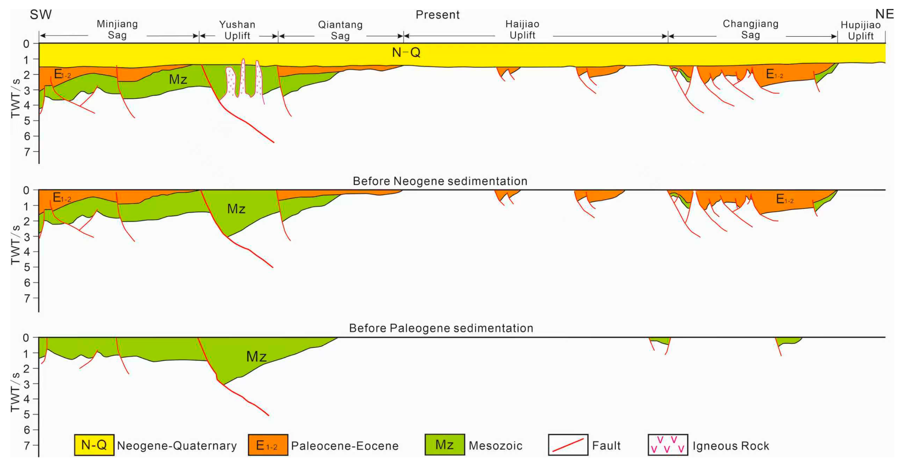
In this study, 2D seismic profiles were interpreted using Petrel (2016) and the results were correlated with well data to determine stratigraphic horizons. The balanced geologic cross-profile restoration technique can be used to check the reasonableness of the interpreted seismic profiles and simultaneously obtain the distribution of strata and tectonic deformation at various stages of basin evolution. In this study, the interpreted profiles are restored using 2DMove (2016) to reconstruct the Meso-Cenozoic tectonic evolution processes of the basin.

4. Results

4.1. Gravity Anomaly

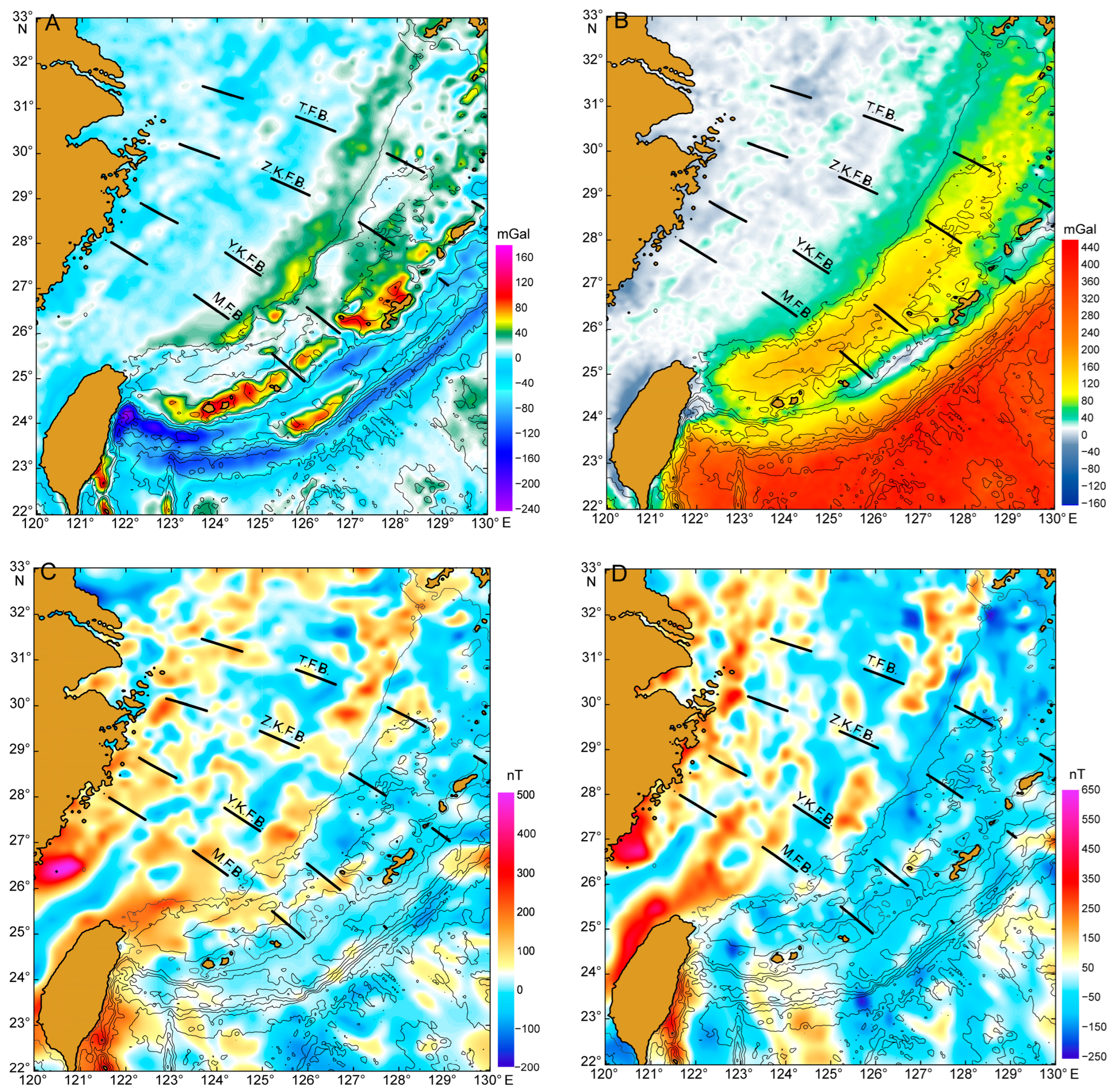
The East China Sea continental shelf is mainly characterized by positive low-amplitude anomalies distributed in large contiguous areas, with outliers ranging from −10 to 20 × 10−5 m/s2. The anomalous advantage trend is NE-NNE (Figure 2A), showing an overall pattern of an east–west belt and north–south block. There is a linear positive anomaly belt with a NNE-SSW direction and 0–20 mGal in the western region, which forms the boundary between the East China Sea continental shelf and Minzhe uplift belt. A high-anomaly belt has developed along the edge of the continental shelf in the east, extending from northeast Taiwan to west Kyushu Island in Japan. The anomaly values are generally greater than 20 × 10−5 m/s2, and locally reach over 60 × 10−5 m/s2. The central continental shelf is dominated by low-amplitude anomalies ranging from −10 to 10 × 10−5 m/s2, with only small areas of high-gravity anomalies exceeding 20 × 10−5 m/s2 occurring north of 30° N. Although the overall amplitude of the spatial gravity anomaly in the East China Sea continental shelf varies slightly, there is a clear correspondence with the basin basement’s undulation, reflecting the structural pattern of the rift-type fault sag basin basement controlled by near-NNE extensional faults and near-NW strike-slip faults.
The Bouguer gravity anomaly in the East China Sea continental shelf is mainly characterized by a positive low anomaly of 0–40 mGal (Figure 2B). The anomalous trend is NE-NNE, which has a similar distribution pattern to the spatial gravity anomaly. From the eastern shelf to the Okinawa Trough, the Bouguer gravity anomaly gradually increases, forming a significant Bouguer gravity gradient belt that indicates significant uplift of the Moho discontinuity in this region.

4.2. Magnetic Anomaly

The ΔT magnetic anomaly of the East China Sea continental shelf varies greatly, with anomaly values ranging from −200 to 500 nT (Figure 2C). The main trend of the magnetic anomaly is NE, and the locally dominant trend is NW-NWW, with obvious east–west belting characteristics. There is a wide positive high magnetic anomaly belt in the western continental shelf, extending northward to the vicinity of Jeju Island, with a decreasing trend in magnetic anomaly amplitude from south to north. The positive and negative magnetic anomaly belts are distributed alternately in the central continental shelf, with small variations in anomaly amplitude, mostly between −50 and 50 nT. Only a positive high magnetic anomaly zone with a large area appears in the southern part, which is connected to the positive magnetic anomaly zone in Taiwan and the western end of the Okinawa Trough. A string-of-beads-like positive magnetic anomaly belt extends along the eastern margin of the shelf from west of Kyushu, Japan, to approximately 26° N, and is segmented north of 28° N by a NWW negative anomaly zone. The polarization magnetic anomaly and ΔT magnetic anomaly in the East China Sea Shelf have similar distribution characteristics, with only a large negative anomaly area appearing on the shelf north of 29° N, while two bead-like high magnetic anomaly belts have developed on the shelf south of this (Figure 2D).
The high magnetic anomaly area in the western ECSSB corresponds to the Minzhe uplift belt. Due to the widespread distribution of strong magnetic Meso-Cenozoic igneous rocks in the Minzhe land area [27,28], it is believed that the positive high magnetic field in the sea area is also formed by shallow buried intrusive rocks above the uplift. Owing to the influence of thick sedimentary cover in the ECSSB, the amplitude of background magnetic anomalies in the central shelf area is relatively low, with positive and negative anomalies corresponding to basement uplift and sag, respectively. However, several equant, high-amplitude positive magnetic anomalies occur in the central–southern profile, which are inferred to arise from igneous intrusions, and some have already been confirmed by drilling and seismic profiles. The high magnetic anomaly belt on the eastern edge of the continental shelf corresponds to the Diaoyu Islands uplift belt, where the bead-like distribution of positive high magnetic anomaly traps is caused by igneous rocks within the basement, indicating that the uplift fold belt has undergone large-scale magmatic alteration. The positive anomaly belt near 28° N and 26° N is divided by the NWW negative anomaly belt. The negative anomaly belt extends westward from the Ryukyu Island arc to the East China Sea continental shelf, which may be related to a large strike-slip fault [29].

4.3. Differences in Basin Structural Deformation

Based on the detailed structural interpretation of multi-channel two-dimensional seismic profiles within the basin, the ECSSB was analyzed in terms of basin structure, fault and igneous rock development, and structural styles. It was found that there were significant differences in structural deformation between the northern and southern ECSSB.
The Changjiang sag in the northern ECSSB is a small rift-type fault sag basin from the late Cretaceous to the Cenozoic Era, with only thin late Cretaceous and Cenozoic strata developed. The Xihu sag, on the other hand, is composed of five structural layers since the Paleocene: the fault sag structural layer, the fault sag transformation structural layer, the sag structural layer, the inversion structural layer, and the regional subsidence structural layer. The maximum thickness of the strata can reach 15,000 m [30]. The central ECSSB is located above the basement and has experienced regional subsidence since the Miocene, with locally developed small half-grabens from the Paleocene to the Eocene. The southern ECSSB is a large Meso-Cenozoic fault sag superimposed basin, with the lower part being a Mesozoic sag basin and the upper part being a Cenozoic fault sag basin. Overall, the southern Meso-Cenozoic is widely distributed and thick, while the northern part has a relatively limited distribution. The Yushan–Kume fault is the key boundary line for the north–south difference (Figure 2 and Figure 3).
There are 1–2 NW trending deep faults that have developed in the northern ECSSB, which are the north–south boundary faults of the Changjiang sag and control the formation time and development scale of the Changjiang sag. In addition, the remaining faults are mostly small-scale structures confined within the Changjiang sag, influencing only the architecture of subordinate depressions. The seismic profile reveals the development of two large deep faults in the central ECSSB. There is a significant difference in the burial depth of the magnetic basement between the north and south [24,31], which is speculated to be one of the key factors causing the structural deformation differences between the north and south of the ECSSB. In the southern ECSSB, deep NW faults are more developed, with a larger number and scale. The deep NW fault in the southern basin directly leads to the structural pattern of the north–south block in the ECSSB. Based on comprehensive gravity and magnetic data, they are believed to be the Yushan–Kume fault and the Zhoushan–Kunigami fault (Figure 3). The two sides of the fault have completely different distribution characteristics of gravity and magnetic anomalies (Figure 2).
Meanwhile, seismic profiles reveal that the southern ECSSB is more significantly affected by deep magmatic activity, and the development of igneous rocks is more extensive than in the northern part. By comparison, it can be seen that there is a good coupling relationship between the development of faults and the formation of igneous rocks, and faults provide important channels for the development of igneous rocks. The structural features revealed by the seismic profiles are in good agreement with the gradually decreasing magnetic anomalies from south to north. Furthermore, it can be inferred that the development of faults and igneous rocks is the main cause of the high magnetic anomalies in the southern part of the ECSSB.
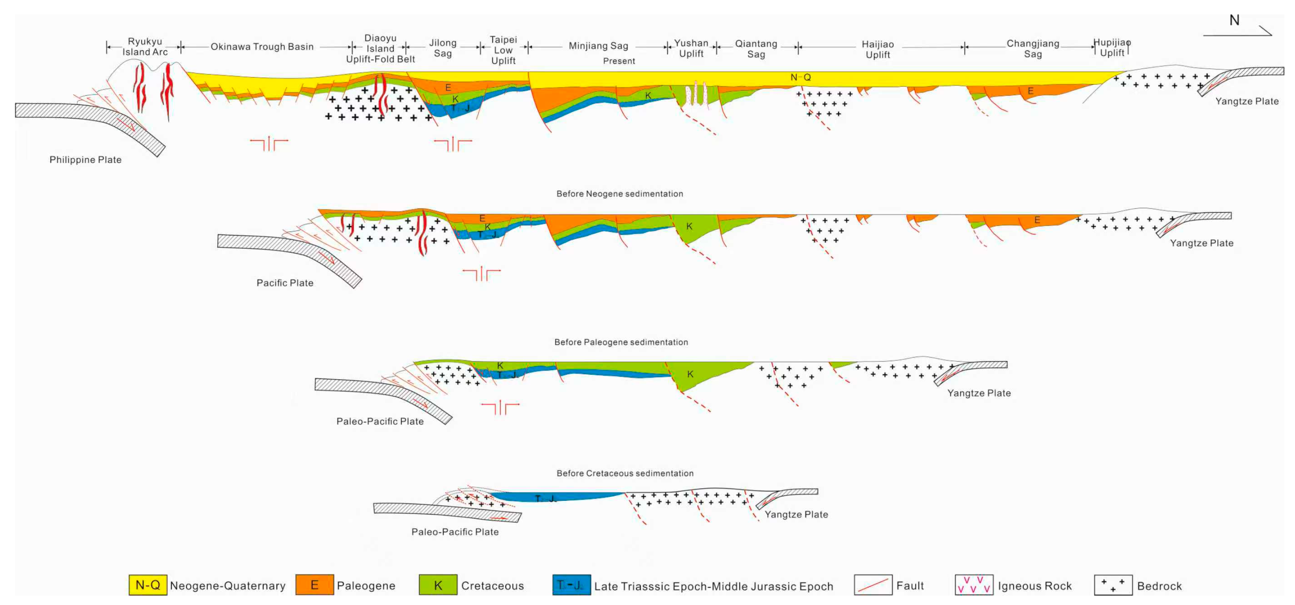
In addition, it is worth noting that there are significant differences in the development of inversion structures between the north and south of the ECSSB. In the northern ECSSB, late Cretaceous–Miocene inversion structures are widely developed in the Changjiang sag and Xihu sag, with at least three stages of structural inversion occurring in the Xihu sag [32,33]. Overall, the phases of the inversion structure gradually become younger from west to east, with a clear migration pattern. However, in the southern ECSSB, the development of rolling anticlines has been observed locally in the Oujiang sag, while there is almost no obvious development of inversion structures in other structural units such as the Minjiang sag and Jilong sag (Figure 3).

4.4. Differences in Deep Geological Structure

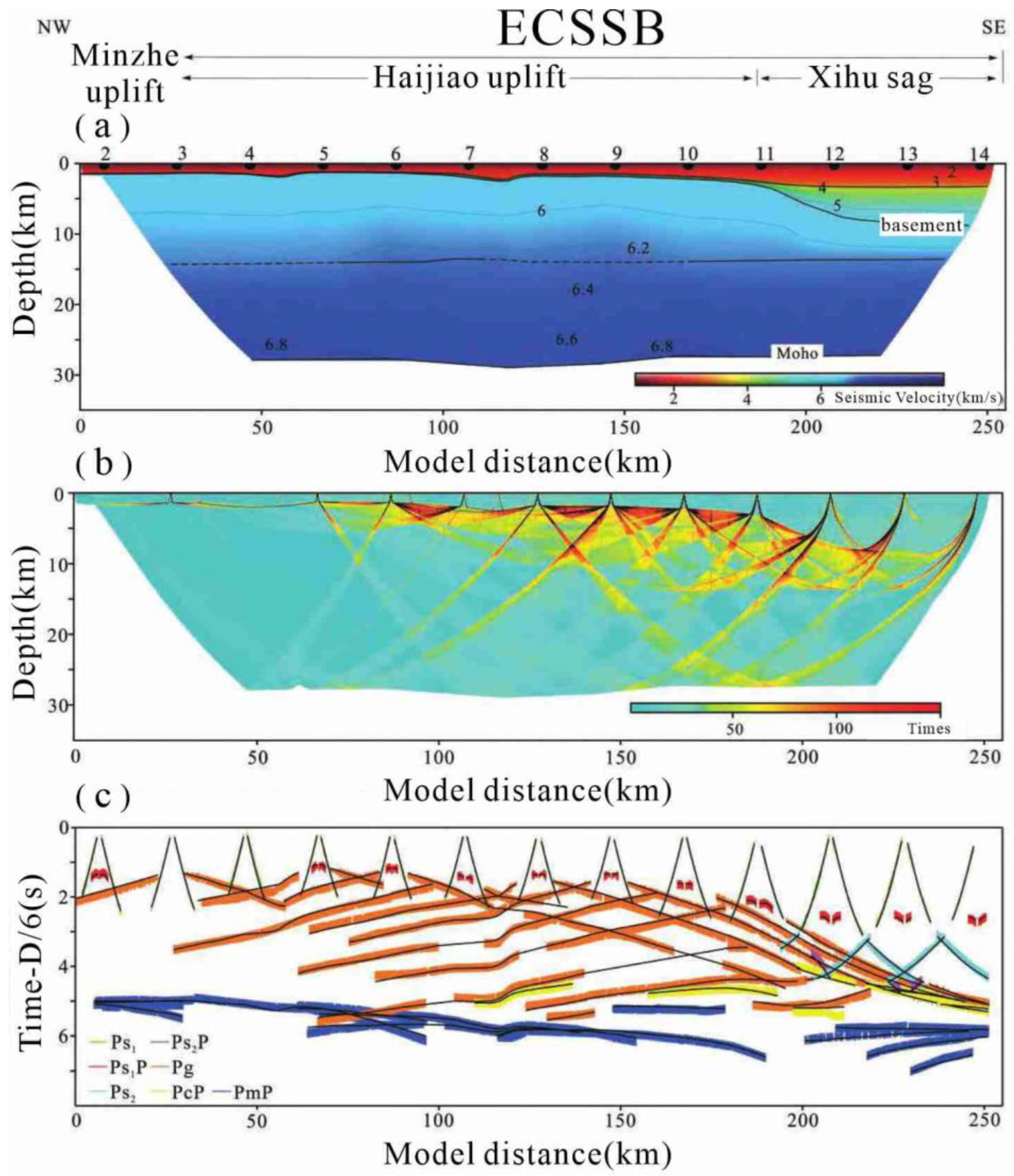
The thickness of the lower crust in the northern ECSSB is about 13–14 km. The Moho is buried at a depth of 28.5 km in the Minzhe uplift, slowly rising eastward to 27.5 km, deepening to 28.5 km at the Haijiao uplift, and then rising to 27.0 km at the Xihu sag. The Moho undulates in a slowly changing convex–concave–convex pattern, and has a mirror-like relationship with the sedimentary basement surface as a whole (Figure 4). The velocity of the lower crustal layer is 6.3~6.8 km/s, with local areas reaching 6.9 km/s. No obvious high-speed anomaly body in the lower crust has been observed [34], suggesting that there is no large-scale magma intrusion or mantle upwelling activity beneath the DP11B survey line (Figure 4).
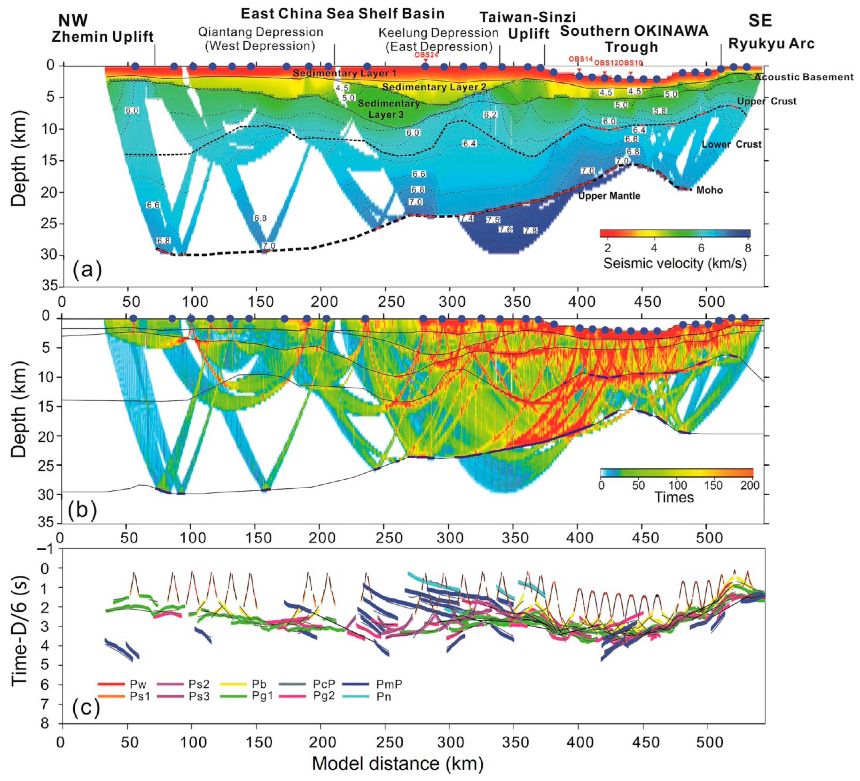
The Mesozoic strata in the southern ECSSB are widely distributed and thick, with a maximum burial depth of about 10 km and a velocity of 5.0~5.5 km/s (Figure 5a). In the southeastern Jilong sag near the Diaoyu Islands uplift belt, a high-speed anomalous body with a speed of about 6 km/s has developed, which is speculated to be a widely developed high-speed magmatic rock intrusion. Shallow multi-channel seismic data has confirmed the existence of igneous rocks [35,36]. The thickness of the upper crust gradually decreases towards the sag area, and there is a shallow high-speed body with a velocity of 6 km/s at 5 km in the Minzhe uplift belt, which is speculated to be a Mesozoic volcanic intrusive rock or metamorphic rock basement. There is a high-speed body above the Moho in the lower crust of the Minzhe uplift belt, Qiantang sag, and Jilong sag, with a velocity of 6.8–7.1 km/s.
The acoustic basement layer in the Okinawa Trough is mainly composed of shallow metamorphic Paleogene, Mesozoic or Paleozoic strata, with a velocity of about 4.0–4.5 km/s and a thickness of about 1.6 km. A large number of high-speed anomalous bodies can be seen in the acoustic basement layer, with a velocity of up to 4.5–5.0 km/s. It is speculated that they are igneous rock intrusions in the basement layer, which is consistent with the information displayed by multiple seismic data points [26]. At the same time, significant, thick high-speed bodies can be seen in the lower crust, with a scale extending from the Moho to most of the lower crust and a velocity of about 6.8–7.1 km/s.

5. Discussion

5.1. The Control Effect of the Strength of Deep Crust–Mantle Activity on the Differences in Geological Structure Between the North and South of the ECSSB

The seismic profile reveals that magmatic rocks have been relatively well-developed in the southern ECSSB since the Mesozoic–Cenozoic (Figure 3), which has had a certain destructive effect on the Meso-Cenozoic strata. The high-speed anomalous body developed at the boundary between the crust and mantle may be caused by mantle magma upwelling, while the continuously developing deep faults provide channels for magma upwelling and intrusion into the basin (Figure 5). In addition, the tearing of subducting plates and the presence of plate edges are also important factors leading to the development of magmatic rocks [38,39,40,41]. Relatively speaking, no high-speed anomalies have developed in the lower crust in the northern basin (Figure 4); instead, there are mainly negative polarization magnetic anomalies, and magmatic rocks have not developed in the shallow sedimentary basin (Figure 2D and Figure 3).
Therefore, based on seismic profile interpretation and the OBS data forward velocity model [34,42], combined with previous research results, it is speculated that the pre-Mesozoic lithosphere was affected by shallow thermal anomalies in the upper mantle [43,44], resulting in thermal uplift and subsequent cooling and thinning. This resulted in crustal subsidence in the southern basin, thereby establishing the paleo-topographic foundation for the formation of the Mesozoic down-warped basins. During this period, the continuous crust mantle interaction may have given rise to the formation and development of early deep-seated faults within the crust. Subsequently, due to the subduction of the colder Paleo-Pacific Plate hindering the upwelling of the mantle column [45], the crustal mantle interaction may slow down or be intermittent, and the development of deep-seated faults within the crust may briefly cease. Subsequently, the influence of plate subduction or mantle upwelling reactivated, laying the foundation for the formation of large NE and NW faults within the basin (Figure 6).
Relatively speaking, since the pre-Mesozoic, the activity of the deep crust mantle in the northern basin has been relatively weak (Figure 3 and Figure 4), and no phenomenon of deep mantle upwelling has been observed. Due to the influence of regional extension since the late Cretaceous, only basement rifts occurred, resulting in the formation of multiple small grabens. Owing to the influence of the different dynamic factors mentioned above, the northern and southern ECSSB ultimately formed distinct Meso-Cenozoic basin structures.

5.2. Differences in the Tectono-Sedimentary Patterns of the Basins Between the North and South Caused by the Multi-Stage Amalgamation of the Yangtze–Cathaysia Blocks

The process of the Yangtze block and the Cathaysia block merging has undergone multiple periods of composite evolution, which has had a profound impact on the geological structure of South China [46,47,48]. During the Jinning time interval (1000–800 Ma), the Yangtze block and the Cathaysia block merged along the Jiangshao fault [49]. Later, they were almost simultaneously disintegrated by the extensional structures caused by the Rodinia mantle plume, and finally merged along the Zhenghe–Dapu fault during the Caledonian time interval (500–410 Ma) [49].
Under the tectonic background mentioned above, the land area east of the Jiangnan–Shaoxing fault (the Zhejiang–Jiangxi–Fujian–Guangdong region) is characterized by low Bouguer gravity and high magnetic anomalies. This signature denotes an increase in crustal thickness under the influence of block splicing and the distribution of planar intermediate acidic magmatic rocks [50]. Meanwhile, in the northern ECSSB, gravity and magnetic data reveal local crustal thickening to nearly 30 km—about 2 km thicker than the surrounding regions [51].
Affected by the splicing of the above-mentioned land blocks and crustal thickening, the northern ECSSB underwent collision-related uplift and prolonged subaerial erosion before the Cretaceous Period (Figure 7). It was affected by regional extensional activity, forming a small graben until the late Cretaceous. However, the southern ECSSB is far away from the intersection of tectonic plates, and the crustal thickness is relatively thinner. The high-speed anomaly body near the Moho is more developed in the lower crust [42], resulting in more developed magmatic rocks than in the northern ECSSB. Since the Mesozoic, influenced by the subduction of the (Paleo-)Pacific Plate, the southern ECSSB has developed into a large-scale superimposed Meso-Cenozoic basin, exhibiting a structural pattern distinct from that of the northern part (Figure 7). In addition, the southern ECSSB has been influenced by the northward extension of the Neo-Tethys ocean, resulting in the deposition of widely distributed and thick Mesozoic strata [52], exhibiting a completely different tectonic sedimentary pattern from the northern ECSSB (Figure 7).

5.3. The Controlling Effect of Plate Subduction and Deep NW Faults on the Differences in Tectonic Deformation Between the North and South of the ECCSB

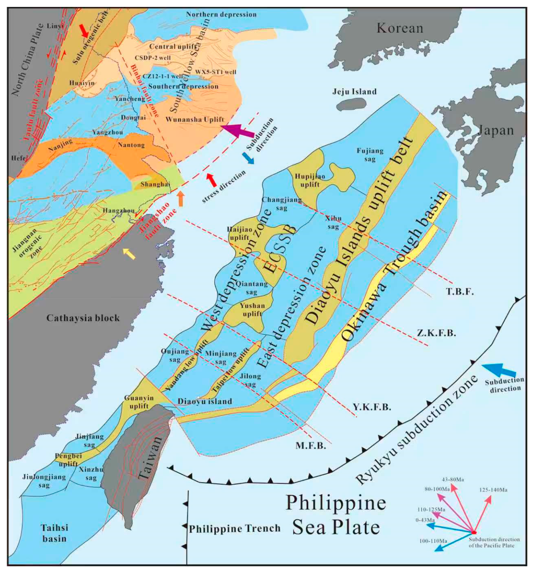
During the Meso-Cenozoic periods, the tectonic evolution of the ECSSB and adjacent areas was mainly influenced by the subduction, collision, and back-arc expansion of the Paleo-Pacific Plate towards the Eurasian Plate (Figure 7), as well as the remote effects of the convergence and wedging of the Indo-Australian Plate towards the Eurasian Plate [23,53,54]. During this period, the direction of plate subduction changed multiple times, and the subduction rate also changed accordingly [55,56,57,58] (Figure 8), all of which were key factors leading to the spatiotemporal differences in basin tectonic deformation.
The multi-stage changes in the direction of plate subduction mentioned above, coupled with variations in subduction rates, led to changes in the direction and magnitude of the stress field within the ECSSB. Affected by changes in the direction of compression or extension forces, NE, NNE, and NWW faults formed within the basin. Meanwhile, influenced by the tuning effect of deep NW faults, there are significant differences in the stress field environment within different structural units in the north and south of the basin, resulting in distinct deformation patterns of basin structures in the north and south. At the same time, the continuous development of NE large controlling concave faults in the basin since the Mesozoic has, to some extent, buffered the compressive stress caused by plate subduction. Therefore, the difference in the development degree of NE controlling concave faults is one of the controlling factors leading to the difference in structural deformation between the north and south. In addition, the continuous long-term subduction of multiple plates towards the Eurasian Plate has led to the bending deformation of the crust on one side of the Eurasian Plate, which is another important reason for the formation of the embryonic form of the Mesozoic sag basin in the ECSSB. It is worth noting that the basement of the East China Sea Shelf Basin is likely a buoyant allochthon that collided with Eurasia during the Cretaceous Period [6].

6. Conclusions

  • The southern and northern ECSSB have significantly different Meso-Cenozoic basin structures. The southern part is a large Meso-Cenozoic fault sag superimposed basin, with widely distributed and thick Meso-Cenozoic strata that have developed. The northern ECSSB is a fault sag basin dominated by the Cenozoic. The thickness of the Cenozoic strata in the Xihu sag can reach up to 15 km, and multiple periods of structural inversion have developed.
  • Compared with the northern part of the basin, the southern part of the basin has a greater number and larger scale of NW-trending deep faults. Meanwhile, the southern ECSSB is more significantly affected by deep magmatic activities, and igneous rocks are also more developed. It is obvious that there is a good response relationship between the distribution of faults and the development of igneous rocks. It is worth noting that the seismic profile has revealed deep NW faults that developed in the central basin, namely, the Yushan–Kume fault and Zhoushan–Kunigami fault, speculated on by previous researchers based on gravity and magnetic data.
  • During the pre-Mesozoic, mantle upwelling caused thermal uplift of the lithosphere in the southern ECSSB. Later, the subduction of the Paleo-Pacific Plate weakened or interrupted the supply of heat sources, resulting in cooling and contraction of the lithosphere and thermal subsidence, laying the foundation for the formation of the Mesozoic sag basin in ancient landforms. In contrast, the northern ECSSB experienced no lithospheric thermal doming because deep crust–mantle activity remained relatively stable. Extensional faulting did not commence until the late Cretaceous, ultimately producing a basin architecture markedly different from that of the southern basin.
  • During the Cenozoic, the ECSSB experienced complex subduction of the Pacific Plate, with varying directions and rates of subduction, resulting in different tectonic stresses in the basin during different geological periods. At the same time, the deep NW faults widely developed in the basin played a key tuning and transformation role in the subduction compression mentioned above, resulting in significant differences in structural deformation in different geological periods within various structural units in the southern and northern ECSSB.

Author Contributions

Writing—original draft preparation, C.Y.; methodology, J.S.; software, J.L.; formal analysis, Y.Z.; data curation, L.S.; writing—review and editing, Y.Y. All authors have read and agreed to the published version of the manuscript.

Funding

This study is financially supported by Laoshan Laboratory (No. LSKJ202203401), the Natural Science Foundation of Shandong Province (No. ZR2023MD047), the Geological Survey Projects of China Geological Survey (No. DD202403020, No. DD20240302001 and DD20240201206), and the National Natural Science Foundation of China (No. 42476077).

Data Availability Statement

The original contributions presented in this study are included in the article. Further inquiries can be directed to the corresponding author.

Conflicts of Interest

The authors declare that there are no competing financial interests with any other people or groups regarding the publication of this manuscript.

References

  1. Li, S.; Suo, Y.; Li, X.; Zhou, J.; Santosh, M.; Wang, P.; Wang, G.; Guo, L.; Yu, S.; Lan, H.; et al. Mesozoic tectono-magmatic response in the East Asian ocean-continent connection zone to subduction of the Paleo-Pacific Plate. Earth-Sci. Rev. 2019, 192, 91–137. [Google Scholar] [CrossRef]
  2. Zhu, W.L.; Zhong, K.; Fu, X.W.; Chen, C.F.; Zhang, M.Q.; Gao, S.L. The formation and evolution of the East China Sea Shelf Basin: A new view. Earth-Sci. Rev. 2019, 190, 89–111. [Google Scholar] [CrossRef]
  3. Cheng, Y.J.; Wu, Z.P.; Zhang, J.; Liu, Y.Q.; Dai, Y.N. Cenozoic tectonic evolution of offshore Chinese Basins and its response to geodynamic processes of the East Asian Continental Margin. Earth-Sci. Rev. 2022, 232, 104–140. [Google Scholar] [CrossRef]
  4. Zhao, J.H. The forming factors and evolvement of the Mesozoic and Cenozoic vasin in the East China Sea. Mar. Pet. 2004, 24, 6–14, (In Chinese with English abstract). [Google Scholar]
  5. Suo, Y.H.; Li, S.Z.; Yu, S.; Somerville, L.D.; Liu, X.; Zhao, S.J.; Dai, L.M. Cenozoic tectonic jumping and implications for hydrocarbon accumulation in basins in the East Asia Continental Margin. J. Asian Earth Sci. 2014, 88, 28–40. [Google Scholar] [CrossRef]
  6. Wei, X.; Ding, W.; Christeson, G.L.; Li, J.; Ruan, A.; Niu, X.; Zhang, J.; Zhang, Y.; Tan, P.; Wu, Z.; et al. Mesozoic suture zone in the East China Sea: Evidence from wide-angle seismic profiles. Tectonophysics 2021, 820, 229116. [Google Scholar] [CrossRef]
  7. Fu, X.; Ding, W.; Dadd, K.; Li, J.; Zhu, W.; Feng, K.; Geng, J.; Xu, X. An exotic origin of the eastern East China Sea basement before ∼150 Ma. Sci. Bull. 2022, 67, 1939–1942. [Google Scholar] [CrossRef]
  8. Xu, B.; Wu, Z.P.; Cheng, Y.J.; Miocic, J.M.; Dai, Y.N.; Chu, Y.C. Cenozoic structural and tectonic evolution in the Western Xihu Basin, East China Sea Shelf Basin. Int. J. Earth Sci. 2024, 113, 713–732. [Google Scholar] [CrossRef]
  9. Yang, Y.Q.; Yang, C.Q.; Yang, C.S.; Sun, J. Mesozoic fault system in the Southern East China Sea Shelf Basin and its bearing on basin structures. Mar. Geol. Quat. Geol. 2019, 39, 52–61. [Google Scholar] [CrossRef]
  10. Yang, C.; Yang, C.; Yang, Y.; Sun, J.; Wang, J.; Xiao, G.; Wang, J.; Yuan, Y. Deep stratigraphic framework and hydrocarbon resource potential in the Southern East China Sea Shelf Basin. Mar. Geol. Quat. Geol. 2022, 42, 158–171. [Google Scholar]
  11. Li, S.; Zhao, G.; Dai, L.; Zhou, L.; Liu, X.; Suo, Y.; Santosh, M. Cenozoic faulting of the Bohai Bay Basin and its bearing on the destruction of the eastern North China Craton. J. Asian Earth Sci. 2012, 47, 80–93. [Google Scholar] [CrossRef]
  12. Zhang, G.; Anlin, G.; Wang, Y.; Li, S.; Dong, Y.; Liu, S.; He, D.; Cheng, S.; Lu, R.; Yao, A. Tectonics of South China Continent and its implications. Sci. China Earth Sci. 2013, 56, 1804–1828. [Google Scholar] [CrossRef]
  13. Hall, R. Cenozoic geological and plate tectonic evolution of SE Asia and the SW Pacific: Computer-based reconstructions, model and animations. J. Asian Earth Sci. 2002, 20, 353–431. [Google Scholar] [CrossRef]
  14. Jiang, W.; Song, H.; Hao, T.Y.; Liu, S. The characters of geology and geophysics of shell basins of East China Sea and adjacent sea area. Prog. Geophys. 2001, 16, 18–27. [Google Scholar]
  15. Hao, T.Y.; Xu, Y.; Xu, Y.; Mancheol, S.; Liu, J.H.; Dai, M.; Li, Z. Some new understandings on deep structure in Yellow Sea and East China Sea. Chin. J. Geophys. 2006, 49, 458–468. [Google Scholar] [CrossRef]
  16. Zheng, Q.G.; Zhou, Z.; Cai, L.; Lu, Y.; Cao, Q. Meso-Cenozoic tectonic setting and evolution of East China Sea shelf basin. Oil Gas Geol. 2005, 26, 197–201. [Google Scholar]
  17. Cukur, D.; Horozal, S.; Lee, G.H.; Kim, D.C.; Han, H.C.; Kang, M.H. Structural evolution of the northern East China Sea Shelf Basin interpreted from cross-section restoration. Mar. Geophys. Res. 2011, 32, 363–381. [Google Scholar] [CrossRef]
  18. Zhou, X.M.; Li, W.X. Origin of Late Mesozoic igneous rocks in Southeastern China: Implications for lithosphere subduction and underplating of maficb magmas. Tectonophysics 2000, 326, 269–287. [Google Scholar] [CrossRef]
  19. Yang, C.; Li, G.; Luan, X.; Yang, C.; Gong, J.; Yanqiu, Y.; Suo, Y. Geophysical Interpretation and Formation Mechanism of the Yandang Low Uplift in the East China Sea Shelf Basin. Chin. J. Geophys. 2014, 57, 650–662. [Google Scholar] [CrossRef]
  20. Li, J. Geology of the East China Sea Region; China Ocean Press: Beijing, China, 2008. [Google Scholar]
  21. Zhang, X.H.; Zhang, G.W. Continuously striving to create brilliance—Review and Prospect of Two Journals of Marine Geology. Mar. Geol. Quat. Geol. 2008, 28, 34–56+78. [Google Scholar]
  22. Yang, C.S.; Li, S.Z.; Li, G.; Yang, C.Q.; Yang, Y.Q.; Dai, L.M.; Suo, Y.H.; Li, Q.; Jiang, Y.B. Tectonic units and proto-basin of the East China Sea Shelf Basin: Correlation to Mesozoic subduction of the Palaeo-Pacific Plate. Geol. J. 2016, 51, 149–161. [Google Scholar] [CrossRef]
  23. Suo, Y.H.; Li, S.Z.; Cao, X.Z.; Wang, X.Y.; Somerville, I.; Wang, G.Z.; Wang, P.C.; Liu, B. Mesozoic-Cenozoic basin inversion and geodynamics in East China: A review. Earth-Sci. Rev. 2020, 210, 103357. [Google Scholar] [CrossRef]
  24. Han, B.; Zhang, X.H.; Pei, J.X.; Zhang, W.G. Characteristics of crust-mantle in East China sea and adj acent regions. Prog. Geophys. 2007, 22, 376–382, (In Chinese with English abstract). [Google Scholar] [CrossRef]
  25. Zhang, H.; Zhang, X.; Wen, Z.; Lan, X. Geological and Geophysical Series Maps of Eastern China Sea Area and Neighborhood; China Ocean Press: Beijing, China, 2011. [Google Scholar]
  26. Shang, L.N.; Zhang, X.H.; Jia, Y.G.; Han, B.; Yang, C.S.; Geng, W.; Pang, Y.M. Late Cenozoic evolution of the East China continental margin: Insights from seismic, gravity, and magnetic analyses. Tectonophysics 2017, 698, 1–15. [Google Scholar] [CrossRef]
  27. Cukur, D.; Senay, H.; Dae, C.K.; Gwang, H.L.; Hyun, C.H.; Moo, H.K. The distribution and characteristics of the igneous complexes in the northern East China Sea Shelf Basin and their implications for hydrocarbon potential. Mar. Geophys. Res. 2010, 31, 299–313. [Google Scholar] [CrossRef]
  28. Yao, Z.; Li, C.-F.; He, G.; Tao, T.; Zheng, X.; Zhang, T.; Tang, X.; Zhao, T. Cenozoic sill intrusion in the central and southern East China Sea Shelf Basin. Mar. Pet. Geol. 2020, 119, 104465. [Google Scholar] [CrossRef]
  29. Li, N. Preliminary study on the transverse fault of the Okinawa Trough. Acta Oceanol. Sin. 1990, 4, 455–462. [Google Scholar]
  30. Zhang, S.; Zhang, J.; Tang, X.; Zhang, T. Geometry characteristic of the fault system in Xihu sag in East China Sea and its formation mechanism. Mar. Geol. Quat. Geol. 2014, 34, 87–94. [Google Scholar] [CrossRef]
  31. Lin, J.; Sibuet, J.; Hsu, S. Distribution of the East China Sea continental shelf basins and depths of magnetic sources. Earth Planets Space 2005, 57, 1063–1072. [Google Scholar] [CrossRef]
  32. Hu, M.Y.; Li, S.Z.; Dai, L.M.; Suo, Y.H.; Guo, L.L.; Liu, Z.; Ma, F.F.; Tao, J.L. Numerical dynamic modeling of tectonic inversion in the northeastern Xihu Sag. Mar. Geol. Quat. Geol. 2017, 37, 151–166. [Google Scholar] [CrossRef]
  33. Xu, H.Z.; Wei, F.S.; De, W.Q.; Yun, L.; Bo, C.Z.; Chun, M.L.; Xi, Y.W. Age dating of Paleocene Meirenfeng Formation and its significance for the hydrocarbon source rocks in the East China Sea basin. Mar. Pet. Geol. 2024, 160, 106663. [Google Scholar] [CrossRef]
  34. Zhao, L.H.; Li, Y.Q.; Liu, X.Y.; Zheng, Y.P.; Zhao, Q.; Liu, K.; Zhi, P.Y. Deep seismic phases and crustal structure in the East China Sea shelf. Acta Sci. Nat. Univ. Sunyatseni 2022, 61, 84–93, (In Chinese with English abstract). [Google Scholar]
  35. Yang, C.; Yang, C.; Shang, L.; Yan, Z.; Yang, Y. Discovery of Late Cretaceous-Paleocene faulted basins developed on the Yandang Low Uplift, East China Sea Shelf Basin. China Geol. 2019, 2, 243–244. [Google Scholar] [CrossRef]
  36. Yang, C.; Han, B.; Yang, C.; Yang, Y.; Sun, J.; Yu, F. Mesozoic basin evolution of the East China Sea Shelf and tectonic system transition in Southeast China. Geol. J. 2020, 55, 239–252. [Google Scholar] [CrossRef]
  37. Qi, J.; Zhang, X.; Wu, Z.; Meng, X.; Shang, L.; Li, Y.; Guo, X.; Hou, F.; He, E.; Wang, Q. Characteristics of crustal variation and extensional break-up in the Western Pacific back-arc region based on a wide-angle seismic profile. Geosci. Front. 2021, 12, 101082. [Google Scholar] [CrossRef]
  38. Li, X.; Guo, K.; Li, S.; Yang, H.; Pi, J.; Zhong, Y.; Chen, L.; Suo, Y.; Stern, R.J.; Wang, X.; et al. Arc magma heterogeneity induced by subslab mantle upwelling. Geology 2024, 52, 870–874. [Google Scholar] [CrossRef]
  39. Yu, H.S.; Jinder, C. Cenozoic basins in northern Taiwan and tectonic implications for the development of the eastern Asian continental margin. Palaeogeogr. Palaeoclimatol. Palaeoecol. 1997, 131, 133–144. [Google Scholar] [CrossRef]
  40. Morley, C.K. Late Cretaceous–Early Palaeogene tectonic development of SE Asia. Earth-Sci. Rev. 2012, 115, 37–75. [Google Scholar] [CrossRef]
  41. Xu, J.Y.; Zvi, B.A.; Tom, K.; Ho, S.Y. Origin of marginal basins of the NW Pacific and their plate tectonic reconstructions. Earth-Sci. Rev. 2014, 130, 154–196. [Google Scholar] [CrossRef]
  42. Qi, J.H.; Wu, Z.Q.; Zhang, X.H.; Wen, Z.H.; Meng, X.J.; Shang, L.N.; Hou, F.H.; Hu, G. Deep Seismic Evidence of Cenozoic Tectonic Migration in the Western Pacific Back-Arc Area. Earth Sci.-J. China Univ. Geosci. 2020, 45, 2495–2507, (In Chinese with English abstract). [Google Scholar]
  43. Zhou, X.; Zhang, H. Highly Chemical Heterogeneity of Subcontinental Lithosphere Mantle beneath North China and its Major Transformation. Earth Sci. Front. 2006, 31, 8–13. [Google Scholar]
  44. Liu, Z.; Dai, L.M.; Li, S.Z.; Guo, L.L.; Hu, M.Y.; Ma, F.F.; Tao, J.L.; Yang, C.Q.; Suo, Y.H. Mesozoic magmatic activity and tectonic evolution in the southern East China Sea Continental Shelf Basin: Thermo-mechanical modelling. Geol. J. 2017, 53, 240–251. [Google Scholar] [CrossRef]
  45. Niu, Y. Generation and Evolution of Basaltic Magmas: Some Basic Concepts and a New View on the Origin of Mesozoic-Cenozoic Basaltic Volcanism in Eastern China. Geol. J. China Univ. 2005, 11, 9–46. [Google Scholar]
  46. Li, X.; Li, W.; Li, Z.; Lo, C.; Wang, J.; Ye, M.; Yang, Y. Amalgamation between the Yangtze and Cathaysia Blocks in South China: Constraints from SHRIMP U–Pb zircon ages, geochemistry and Nd–Hf isotopes of the Shuangxiwu volcanic rocks. Precambrian Res. 2009, 174, 117–128. [Google Scholar] [CrossRef]
  47. Wang, L.; Lin, S.; Xiao, W. Yangtze and Cathaysia blocks of South China: Their separate positions in Gondwana until early Paleozoic juxtaposition. Geology 2023, 51, 723–727. [Google Scholar] [CrossRef]
  48. Dong, Y.; Hui, B.; Sun, S.; He, D.; Sun, J.; Zhang, F.; Cheng, C.; Yang, Z.; Shi, X.; Zang, R.; et al. Neoproterozoic tectonic evolution and proto-basin of the Yangtze Block, China. Earth-Sci. Rev. 2024, 249, 104669. [Google Scholar] [CrossRef]
  49. Zhang, G.W.; Guo, A.L.; Wang, Y.J.; Li, S.Z.; Dong, Y.; Liu, S.F.; He, D.F.; Cheng, S.Y.; Lu, R.K.; Yao, A.P. The Structure and Problems of the South China Continent in China. Sci. Sin. (Terrae) 2013, 43, 1553–1582. [Google Scholar]
  50. Guo, L.H.; Gao, R.; Zhang, J.; Xiong, X. The Neoproterozoic Yangtze—Huaxia Block Fusion Belt: Insights from the South China Gravity and Magnetic Anomalies. Chin. J. Geol. (Sci. Geol. Sin.) 2016, 51, 682–693. [Google Scholar]
  51. Han, B.; Zhang, X.H.; Yang, J.; Pei, J. The multiple-height analytical continuation in processing the gravity anomaly data from the East China Sea and adjacent regions. Chin. High Technol. Lett. 2007, 17, 1272–1277. [Google Scholar]
  52. Zhong, G.; Su, P.; Feng, C.; Liu, S.; Sun, M.; Yi, H.; Zhao, J.; Zhao, Z. Mesozoic tectonic characteristics and exploration prospects of the Chaoshan depression in the northeastern South China Sea. Acta Geol. Sin. 2022, 96, 2896–2905. [Google Scholar]
  53. Li, S.; Suo, Y.; Li, X.; Wang, Y.; Cao, X.; Wang, P.; Guo, L.; Yu, S.; Lan, H.; Li, S.; et al. Mesozoic plate subduction in West Pacific and tectono-magmatic response in the East Asian ocean-continent connection zone. Chin. Sci. Bull. 2018, 63, 1550–1593. [Google Scholar] [CrossRef]
  54. Zhu, W.L.; Xu, X.H.; Wang, B.; Cao, Q.; Chen, C.F.; Gao, S.L.; Feng, K.L.; Fu, X.W. Late Mesozoic continental arc migration in southern China and its effects on the evolution of offshore forearc basins. Earth Sci. Front. 2022, 29, 277–290. [Google Scholar] [CrossRef]
  55. Zhang, Q. Is the Mesozoic magmatism in eastern China related to the westward subduction of the Pacific plate? Acta Petrol. Mineral. 2013, 32, 113–128. [Google Scholar]
  56. Seton, M.; Flament, N.; Whittaker, J.; Müller, R.D.; Gurnis, M.; Bower, D.J. Ridge subduction sparked reorganization of the Pacific plate-mantle system 60–50 million years ago. Geophys. Res. Lett. 2015, 42, 1732–1740. [Google Scholar] [CrossRef]
  57. Ma, Q.; Xu, Y.G. Magmatic perspective on subduction of Paleo-Pacific plate and initiation of big mantle wedge in East Asia. Earth-Sci. Rev. 2021, 213, 103473. [Google Scholar] [CrossRef]
  58. Wei, J.; Dai, S.; Cheng, H.; Wang, H.; Wang, P.; Li, F.; Xie, Z.; Zhu, R. Review of Asymmetric Seafloor Spreading and Oceanic Ridge Jumps in the South China Sea. J. Mar. Sci. Eng. 2024, 12, 408. [Google Scholar] [CrossRef]
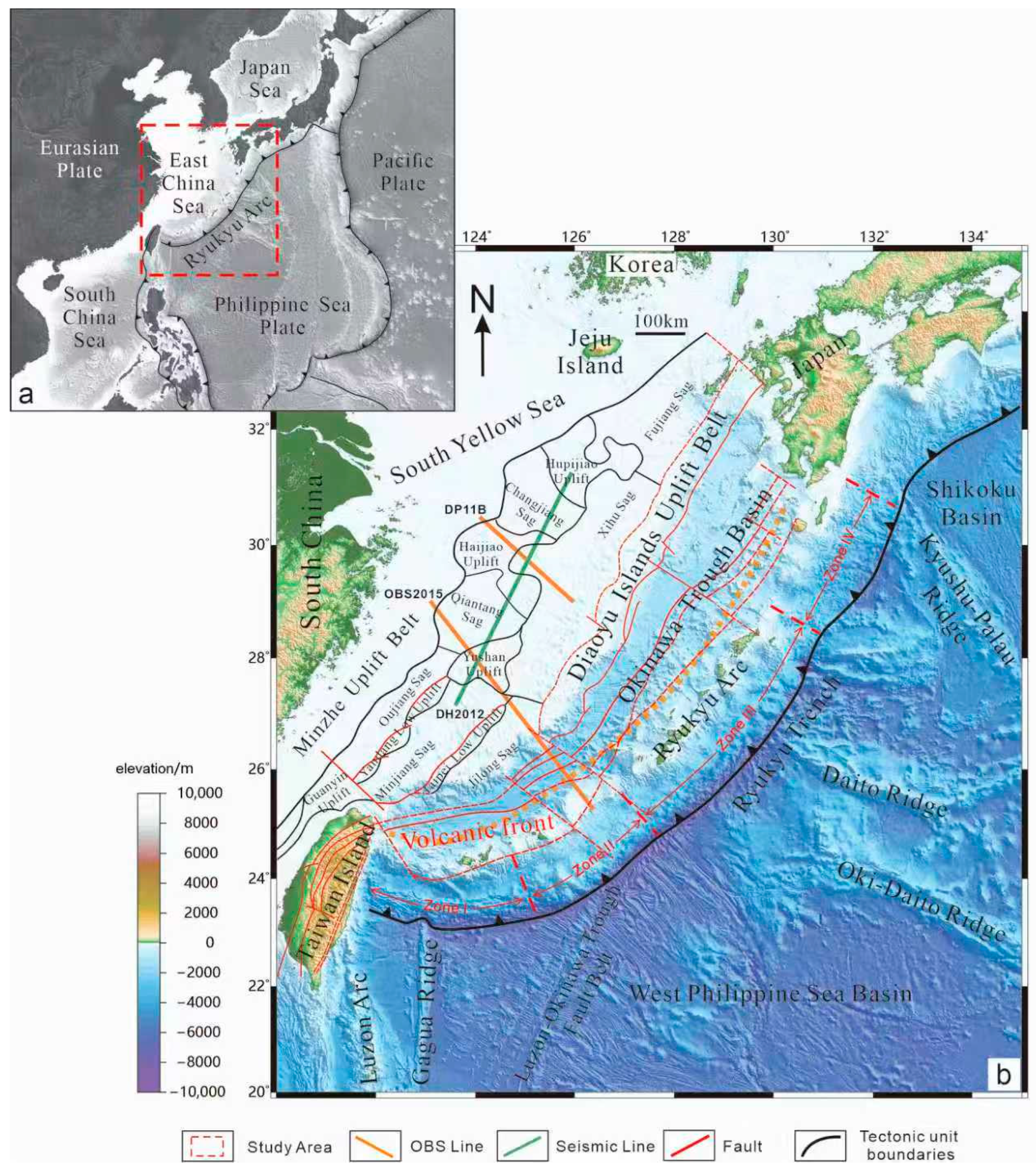
Figure 1. (a) Plate tectonic background of the East China Sea shelf basin. The red dotted line indicates the area of (b). (b) Tectonic zoning map of the East China Sea. ECSSB, East China Sea Shelf Basin.
Jmse 13 01809 g001
Figure 2. Okinawa Trough gravity and magnetic anomaly map [26]. (A) Free space gravity anomaly, (B) Bouguer gravity anomaly, (C) ΔT magnetic anomaly, (D) polarized magnetic anomaly. The black dashed line represents the main northwest trending fault belt: the Tokara fault belt (TFB); Zhoushan–Kunigami fault belt (ZKFB); Yushan–Kume fault belt (YKFB); Miyako fault belt (MFB).
Jmse 13 01809 g002
Figure 3. Prestack time-migrated seismic reflection profile DH2012 (location shown in Figure 1).
Jmse 13 01809 g003
Figure 4. Result of the DP11B’s movement with time using RayInvr coding (location shown in Figure 1). (a) Results of the DP11B profile’s forward-velocity Ray Invr model; (b) Ray coverage density throughout the model; (c) all selected (colors) and calculated (black dots) travel times of the same phases for all of the receivers in the model [34].
Jmse 13 01809 g004
Figure 5. Result of the OBS2015 movement with time using RayInvr coding (location shown in Figure 1). (a) Results of the OBS2015 profile’s forward-velocity Ray Invr model; (b) Ray coverage density throughout the model; (c) all selected (colors) and calculated (black dots) travel times of the same phases for all of the receivers in the model [37].
Jmse 13 01809 g005
Figure 6. Equilibrium geological profile DH2012 in the ECSSB (location shown in Figure 1).
Jmse 13 01809 g006
Figure 7. The geodynamic model of the ECSSB.
Jmse 13 01809 g007
Figure 8. Deep dynamic mechanism of the formation of the Lower Yangtze–South Yellow Sea. The red dashed line represents the main northwest trending fault belt: the Tokara fault belt (TFB); Zhoushan–Kunigami fault belt (ZKFB); Yushan–Kume fault belt (YKFB); Miyako fault belt (MFB). The big colored arrow stands for Subduction direction, and the small colored arrow stands for stress directon. The subduction direction of the Pacific plate is modified according to Zhang (2013) [55].
Jmse 13 01809 g008
Disclaimer/Publisher’s Note: The statements, opinions and data contained in all publications are solely those of the individual author(s) and contributor(s) and not of MDPI and/or the editor(s). MDPI and/or the editor(s) disclaim responsibility for any injury to people or property resulting from any ideas, methods, instructions or products referred to in the content.