Article

Reconstruction of the Cretaceous Palaeogeographic Position of Hainan Island and Its Tectonic Significance

1
School of Resources and Civil Engineering, Suzhou University, Suzhou 234000, China
2
Centre for Marine Magnetism, Department of Ocean Science and Engineering, Southern University of Science and Technology, Shenzhen 518000, China
3
School of Earth and Space Sciences, University of Science and Technology of China, Hefei 230000, China
4
School of National Safety and Emergency Management, Beijing Normal University, Zhuhai 519000, China
5
Guangzhou Marine Geological Survey, Guangzhou 510000, China
6
Shanghai Sheshan National Geophysical Observatory, Shanghai 200000, China
*
Author to whom correspondence should be addressed.
J. Mar. Sci. Eng. 2025, 13(9), 1681; https://doi.org/10.3390/jmse13091681
Submission received: 21 July 2025 / Revised: 29 August 2025 / Accepted: 29 August 2025 / Published: 1 September 2025
(This article belongs to the Section Geological Oceanography)

Abstract

Reconstruction of the palaeogeographical location of Hainan Island is important for understanding the interaction between Indochina and South China. In this study, we integrate topographic relief, gravity anomalies, and magnetic anomalies, along with geological constraints, to determine the Cretaceous location of Hainan Island. The results show that Hainan Island was connected with South China in the Cretaceous and located in the Beibu Gulf Basin, and then rifted from South China with about 230 km displacement along the southeast direction during the Cenozoic. Further geological evidence suggests that Hainan Island and South China have co-evolved since at least the Permian. Hainan Island was rifted from South China from the Palaeocene to the Oligocene due to escape tectonics caused by the India–Asia collision. These new findings provide important clues for investigating the impact of the India–Asia collision and the continental margin evolution of South China.

1. Introduction

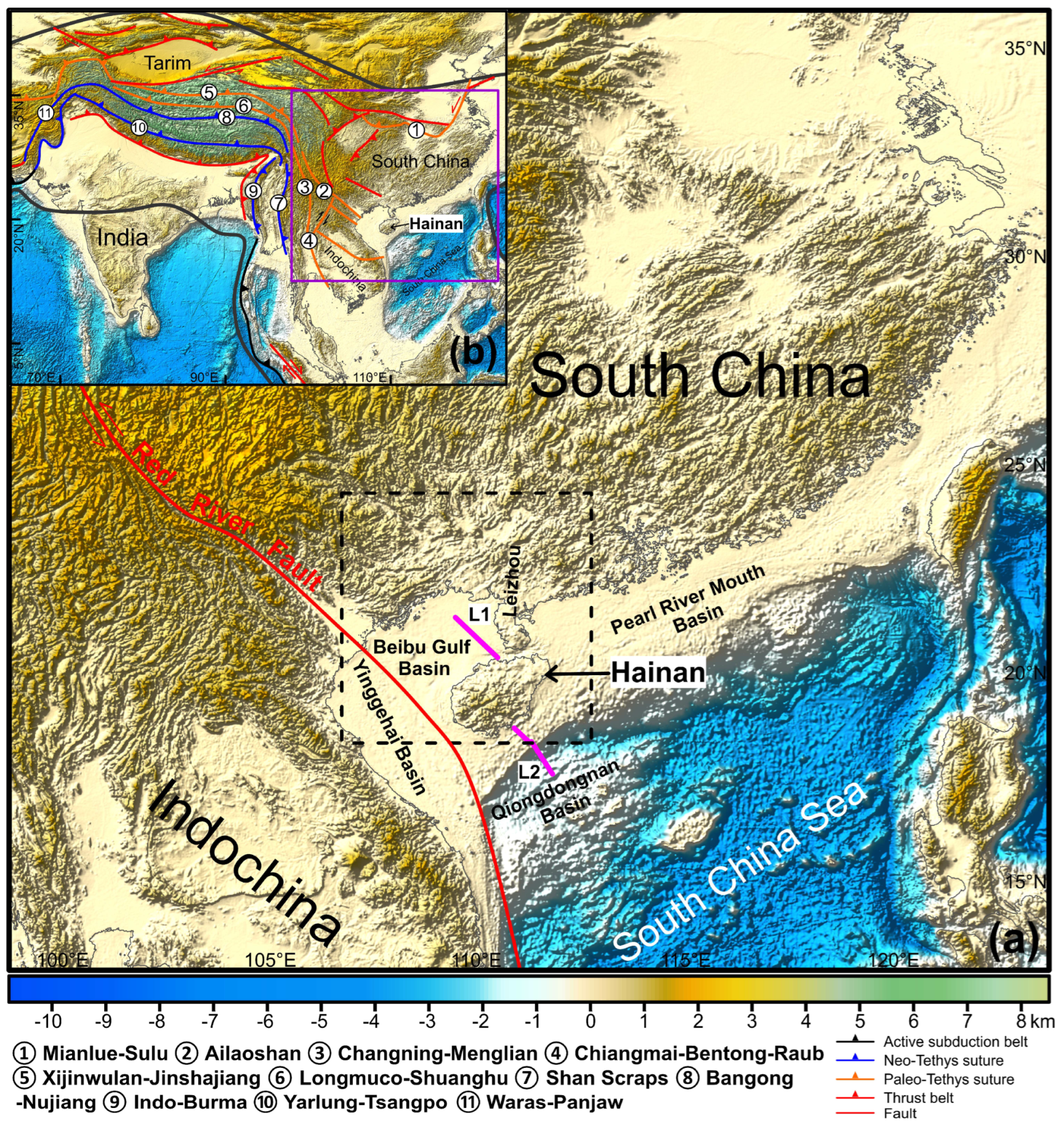
The continental collision after the closure of the Tethyan oceans played a significant role in the formation of the Asian continent [1,2,3]. Hainan Island is located at the junction of South China, Indochina, and the South China Sea (Figure 1). It is the key area for decoding the opening and closing of the eastern Tethyan oceans, the collision of India and Eurasia, and the continental margin evolution of South China [4,5,6,7,8,9,10,11,12].
It is widely believed that Hainan Island, South China, and Indochina blocks drifted northward from the northern margin of Gondwana to their present positions [13,14,15,16,17]. However, different views are proposed for the relationship between Hainan Island and South China; for example, Hainan Island was a microcontinent of Gondwana and drifted northward to the southern margin of South China Block [18,19], Hainan Island maintained a relatively stable position with South China, and drifted together from Gondwana to its present location [20], and Hainan Island was a part of South China and separated from South China in Cenozoic [21,22,23]. The uncertainties have given rise to a widespread controversy regarding the tectonic evolution of Hainan Island. For example, multiple possible sutures have been proposed through Hainan Island [24,25,26]. Therefore, the reconstruction of the island’s palaeogeographical position is crucial for constraining its tectonic framework and exploring the interactions between Indochina, South China, and Hainan Island.
Figure 1. (a) The current geographical location of Hainan Island. The black dotted box shows the locations of the study area. (b) The tectonic background of Hainan Island. The purple solid box represents the location of (a). The location of sutures is shown in (b) [27,28,29].
Jmse 13 01681 g001
This paper presents a comprehensive study of topographic relief, gravity anomalies, and magnetic anomalies, as well as the distribution of strata and granites, to investigate the Cretaceous palaeogeographical position of Hainan Island and provide a tectonic model for the Cenozoic evolution of the study area.

2. Geological Setting

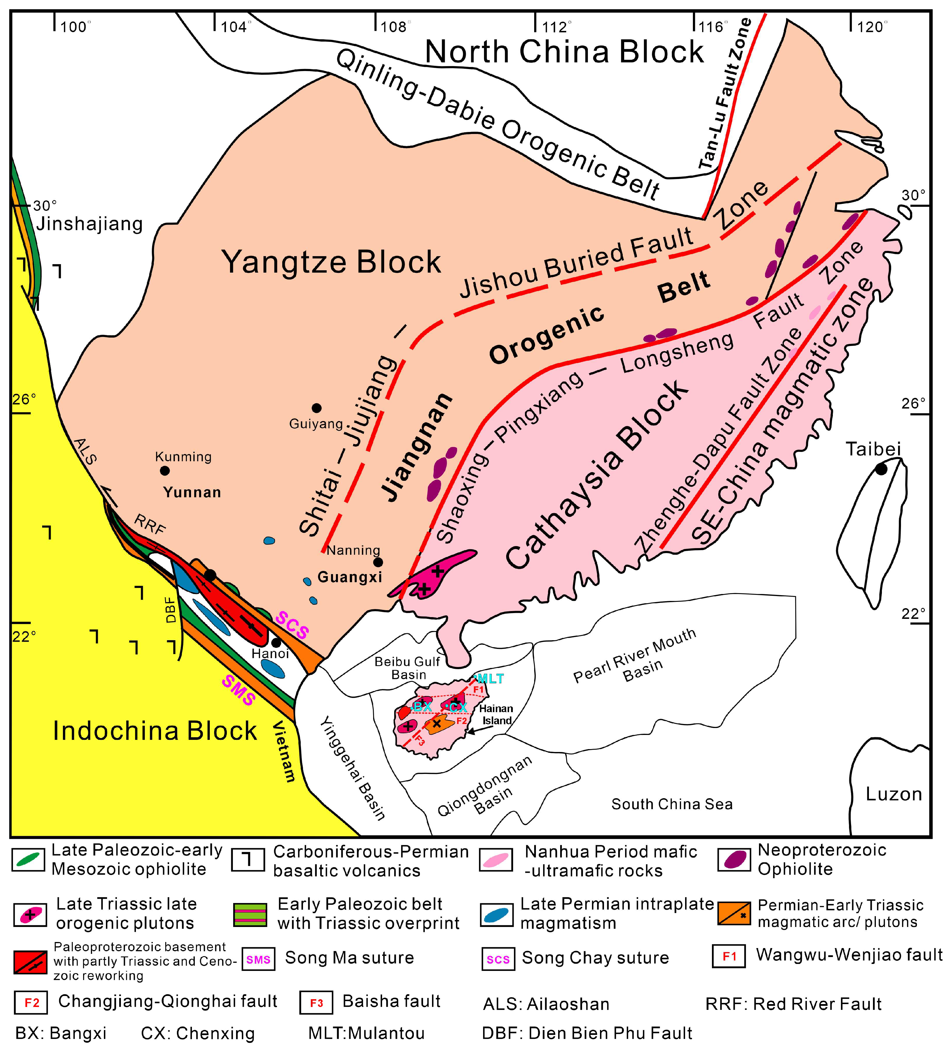
Hainan Island is geographically surrounded by Indochina, South China, and the South China Sea (Figure 2). South China is formed by the amalgamation of the Yangtze and Cathaysia blocks along the Jiangnan orogenic belt [30,31]. The Red River Fault is a Cenozoic left-lateral shear structure in northern Vietnam, and accommodated the extrusion of Indochina due to India–Asia collision [32,33,34,35]. The Song Chay and Song Ma ophiolitic melange represent two ophiolitic sutures. On the basis of similarities in ages, lithology, and structure, they are perceived as united and extend northwestwards to the Ailaoshan and Eastwards to Hainan [36,37,38]. Four Cenozoic basins surround Hainan Island, namely the Yinggehai Basin in the west, the Pearl River Mouth Basin in the East, the Beibu Gulf Basin in the north, and the Qiongdongnan Basin in the south, and a large number of normal and strike–slip faults developed around Hainan Island [39,40,41,42]. Faults distributed in Hainan Island are mainly in east–west and northeast–southwest directions [43,44]. These faults controlled the sedimentary construction, magmatic activity, mineralization, and the geomorphological settings [45,46]. The Permian–Triassic and Jurassic–Cretaceous granites are widely distributed on Hainan Island [47,48,49,50]. The Cenozoic basalts are mainly exposed in the northern part of Hainan Island [51,52,53]. Carboniferous metamorphosed basalts are exposed in the Bangxi and Chenxing areas of the central Hainan Island [54], and it is speculated that they formed in a narrow ocean basin or back-arc basin environment [55,56].
Paleomagnetic data from Hainan Island and South China suggested that Hainan Island was located 5–6° north of the current position in the Cretaceous, and it was still part of South China in the early Cretaceous [57,58]. Liang [22,23] put forward that in order to reconstruct the pre-Cenozoic position of Hainan Island, Hainan Island needs to have a clockwise rotation of 150°. However, paleomagnetic studies indicate that Hainan Island was separated from South China in the late Cretaceous, and during the separation process, Hainan Island may have undergone a counterclockwise rotation of 4.0 ± 5.8° [58] or a rotation of about 10° [5].
Figure 2. Tectonic map of Hainan Island and its surrounding areas [59].
Jmse 13 01681 g002

3. Methodology and Data Sources

Tectonic activities contribute to the formation of topographic features, underground magmatism, and the distribution of materials [60,61,62,63]. The earlier formed topographic features and deep geological structures can be preserved for a long time, and serve as the framework and foundation for tracing the tectonic affinity of connected blocks [64]. For example, interpreted continuous fault patterns have been used to analyze spatial and temporal deformation and movement of the continental crust [65,66,67,68]. Topographic relief is the intuitive expression of tectonic activity on the surface, while the material distribution and geological structure in the deep underground can be obtained through gravity and magnetic anomalies. If Hainan Island and South China were connected, their topographic relief, gravity anomalies, and magnetic anomalies should show continuity. Therefore, we investigate the affinity between Hainan Island and South China by tracing the continuity of tectonic features, as revealed by topographic relief, gravity anomalies, and magnetic anomalies. Thus, the surface and deep geological structures are combined to determine the relation of tectonic features between Hainan Island and South China. In addition, regional geological data (rock types, tectonic deformation) were also provided to validate the results. The topographic relief and free-air gravity anomaly data are derived from the Scripps Institute of Oceanography [69,70]. The magnetic anomaly data are derived from the World Digital Magnetic Anomaly Map [71]. The geological map is from the International Geological Map of Asia [72].

4. Results

The reconstructed palaeogeographical location of topography, gravity, and magnetic anomalies is shown in Figure 3. The results indicate that the tectonic lines of Hainan Island can be divided into three groups, characterized by orientations of east–west, northeast–southwest, and north–south, respectively (Figure 4). On the basis of topographic features, the east–west tectonic lines A1–A4 in northeastern Vietnam can be continuously extended to tectonic lines A5–A8 in Hainan Island (Figure 4a). The deep structures reflected by the gravity anomalies also show that the east–west gravity anomalies intersect with the northeast–southwest tectonic lines and perturb gravity anomalies in other directions, and exhibit continuity between the tectonic lines A1 and A5, A2 and A6, A4 and A8 (Figure 4d). The east–west tectonic lines can be further attested by the continuity of magnetic anomalies (Figure 4g).
In the northeast–southwest direction, the tectonic lines B1, B2, B3, and B4 of Hainan Island can be connected to the tectonic lines B5, B6, B7, and B8 in South China, respectively (Figure 4b). The tectonic line B9 of South China matches well with tectonic line B10 on the Leizhou Peninsula. Regarding gravity anomalies, the northeast–southwest tectonic lines are consistent with the gravity gradient zone in the same direction (Figure 4e). The tectonic lines B11 and B12 can be extended to the southwest with linear low magnetic anomalies and show significant linear features (Figure 4h).
In the north–south direction, the tectonic lines C1, C2, C3, C4, and C5 of Hainan Island share the same trend as the tectonic lines C6, C7, C8, C9, and C10 of South China, on the basis of topographic relief, gravity anomalies, and magnetic anomalies (Figure 4c,f,i). In particular, the tectonic lines C1 with C6, C4 with C9, and C5 with C10 can also be highlighted by the magnetic anomalies (Figure 4i). Furthermore, the tectonic lines D1, D2, D3, D4, and D5 of Leizhou Peninsula can be confidently linked to tectonic lines D6, D7, D8, D9, and D10 of South China, respectively. The D3 and D8 tectonic lines show apparent structural continuity with the low gravity gradient zone.
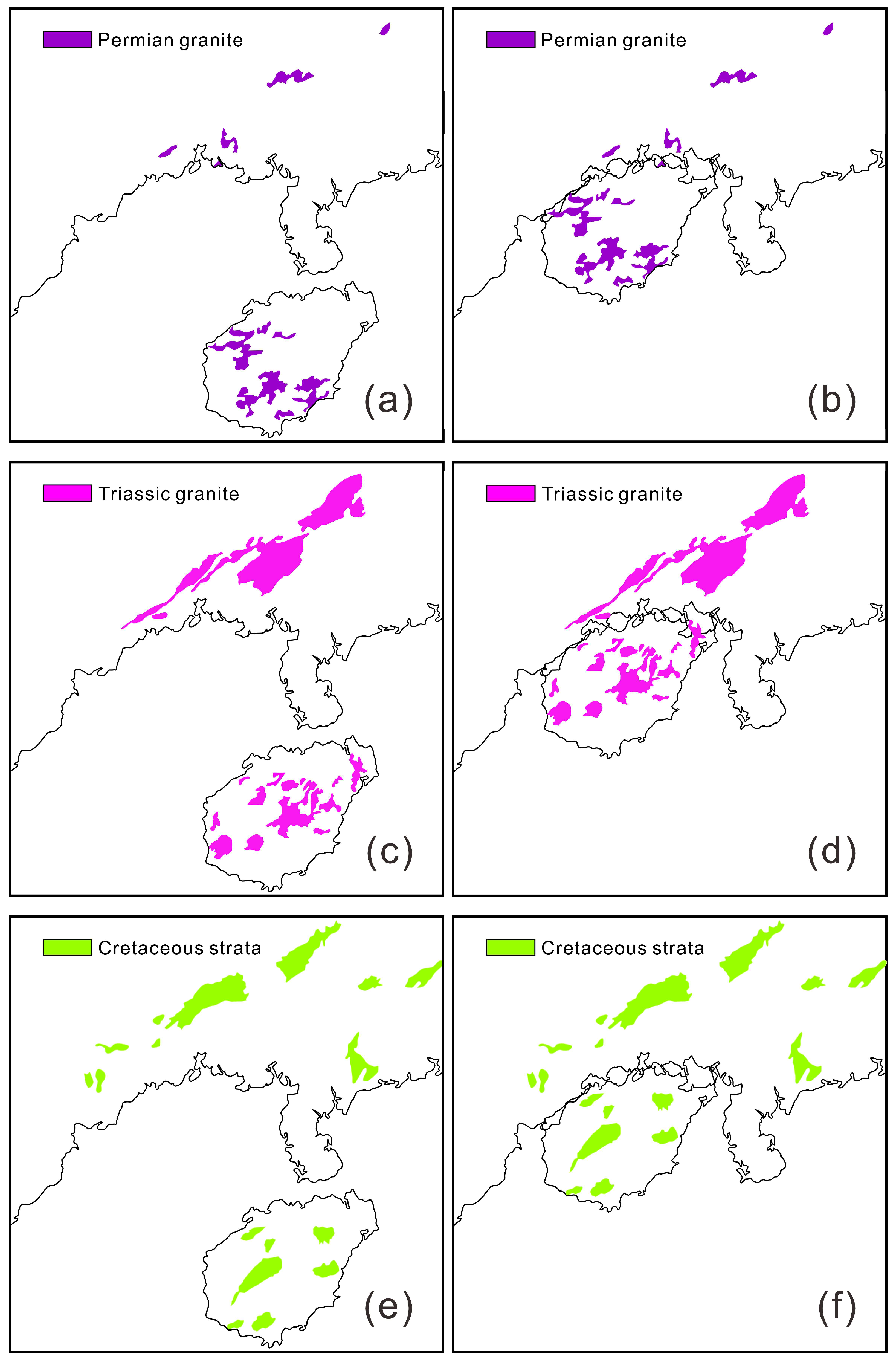
In addition, Hainan Island and South China are similar in distribution of granites and stratigraphy (Figure 5) [72]. On the basis of the reconstructed geological map (Figure 5b,d,f), the pre-Cenozoic stratigraphic orientation of Hainan Island is consistent with that of South China. The strata of Hainan Island after recovery are in the northeast direction, such as the exposed Permian granite, Triassic granite, and Cretaceous strata, which are consistent with the distribution of granites and strata of the same period in South China [72]. This confirms that Hainan Island and South China may have been under a unified tectonic background since the Permian. Therefore, on the basis of the investigation of the relationship between the topographic relief, gravity anomalies, and magnetic anomalies, Hainan Island can be well connected to the South China continent by moving 230 km in the northwest direction. The Leizhou Peninsula is merged into the surrounding area after moving 95 km to the north (Figure 3 and Figure 4). These results support that Hainan Island and South China were connected in the Cretaceous and belonged to a unified tectonic system.
The palaeobotanical study also supports that Hainan Island was adjacent to northern Vietnam and Guangxi (South China) before the Eocene [73]. Replumaz and Tapponnier [21] suggested that Hainan Island separated from the Beibu Gulf Basin, but that no rotation occurred. However, Liang [22] proposed that Hainan Island separated and drifted from the Beibu Gulf Basin, and then rotated counterclockwise by 150°to reach its current location. The restoration of Hainan Island’s palaeogeographical location reveals that the island does not need significant rotation.

5. Discussion

5.1. Breakup of Hainan Island from South China

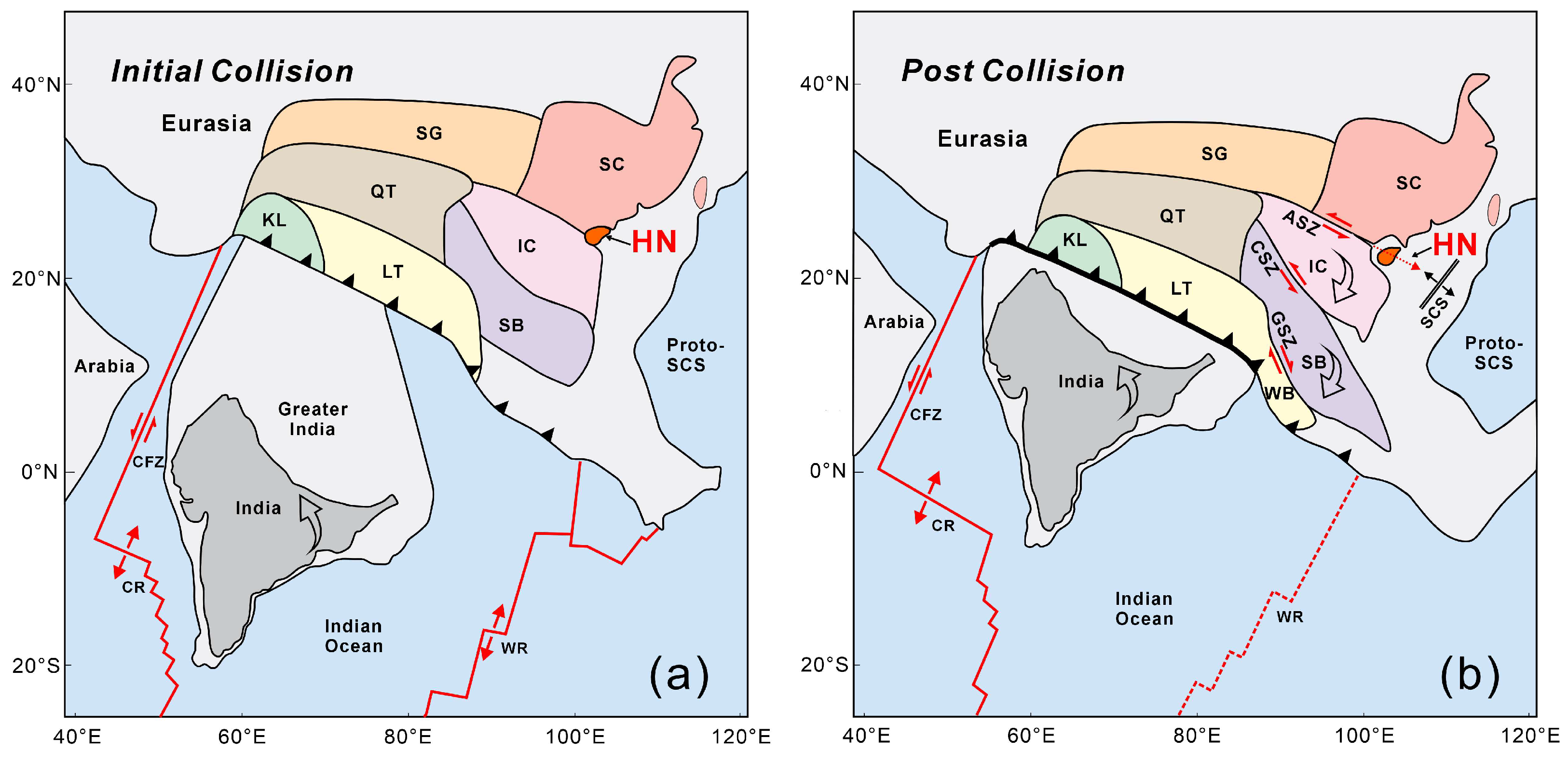
The breakup of Hainan Island from South China may be a consequence of the escape tectonics resulting from the India–Asia collision (Figure 6). The India–Asia collision started in the Palaeocene and completed in the early Miocene [74,75,76]. Following this collision, a sinistral strike–slip movement occurred along the Ailaoshan–Red River shear zone [34], accompanied by the eastward extrusion of Indochina. The strike–slip movement caused the displacement of different pre-existing suture zones and related blocks [33,77,78], and Hainan Island was one of them (Figure 6b).
Structural and geochronological data show that the Ailaoshan, Song-Chay, and Song-Ma tectonic belts were activated and produced sinistral strike–slip stretching due to the Cenozoic extrusion of Indochina [34,37,79]. We suppose the strike–slip movement of the Red River Fault and Dien Bien Phu Fault is recovered. In that case, the Ailaoshan, Song-Chay, and Song-Ma sutures should belong to one united suture zone, which was the original combination boundary of South China and Indochina [14,25]. We speculate that Indochina’s large-scale extrusion and rotational motion promoted the separation of Hainan Island from South China, which was then followed by the island’s southeastward displacement.
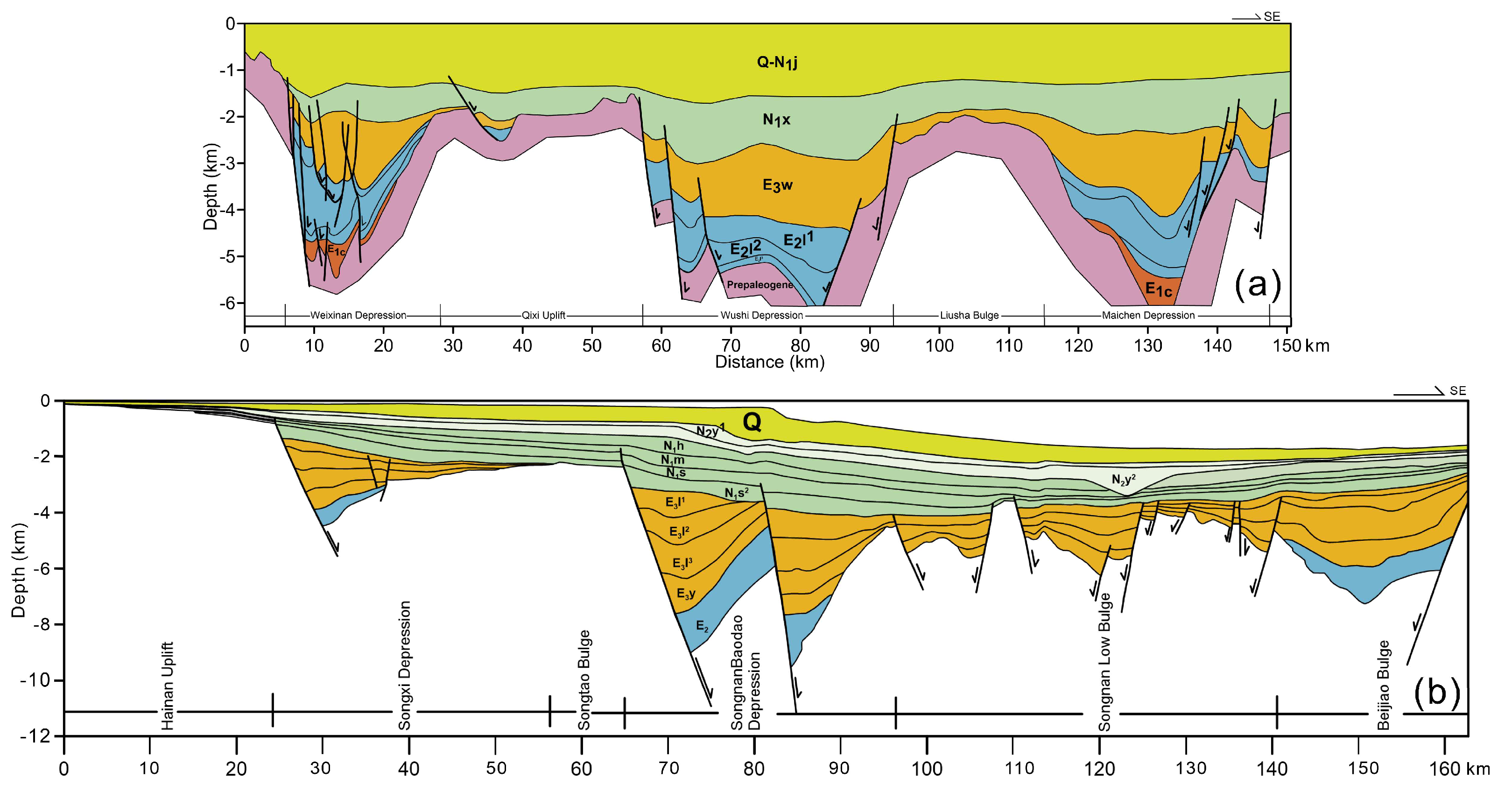
To constrain the breakup time of Hainan Island from South China, geological structural profiles (Figure 7) in Beibu Gulf Basin and Qiongdongnan Basin are used to analyze the evolution of crustal extension in these basins [80]. Figure 7 shows that the sedimentary strata from Palaeocene to Oligocene were wedge-shaped and characterized by grabens or half-grabens, which formed in an extensional environment. The Pre-Palaeogene (>65 Ma) and the Miocene (~23 Ma) strata are almost uniform in thickness and were deposited without prominent extensional deformation (Figure 7). Thus, they may represent the pre- and post-rifting sediments, respectively. The oldest stratum reflecting the extension in the Beibu Gulf basin is the Changliu Formation of the Palaeocene (E1c, Figure 7a), whereas in the Qiongdongnan Basin, it is the Eocene strata (E2, Figure 7b). The absence of Palaeocene strata in the Qiongdongnan Basin, compared with those in the Beibu Gulf Basin, indicates that the separation of Hainan Island was gradually advancing from northwest to southeast. The above evidence shows that the breakup of Hainan Island from South China took place mainly from the Palaeocene (E1, Figure 7a) to the Oligocene (E3, Figure 7a,b).

5.2. Collage of Hainan Island to South China

Our analyses indicate that Hainan Island and South China were once connected. However, the timing of when Hainan Island became geographically connected to the southern part of mainland China remains unclear. Geologically, the evolution of Hainan Island is closely related to the interaction between South China and Indochina. Paleomagnetic, geochronological, and geochemical data indicate that South China, Hainan Island, and Indochina were located on the periphery of East Gondwana in the Early Palaeozoic [1,10,81]. The Paleo-Tethys began to close during the Late Palaeozoic [37,82]. Hainan Island separated from Gondwana, drifted to the north, and accreted onto South China, along with the South China-Indochina collision [15]. The collision can be briefly described as a consequence of the closure of a part of the Paleo-Tethys ocean in the Middle Triassic, after which the South China Block underwent southward continental subduction beneath the Indochina block. Generally, the collision between Indochina and South China is regarded as having occurred in the Triassic [14,83,84].
Nevertheless, some researchers contend that the ductile deformation in the Triassic is an intraplate transcurrent reworking, and the actual collision occurred in the Early Palaeozoic [1,85]. The restoration of the geological map of Hainan Island (Figure 5) reveals that the Permian granite, Triassic granite, and Cretaceous strata in Hainan Island exhibit consistency with the distribution of granite and strata of the same periods in South China. This may indicate that Hainan Island and South China have undergone co-evolution since at least the Permian.
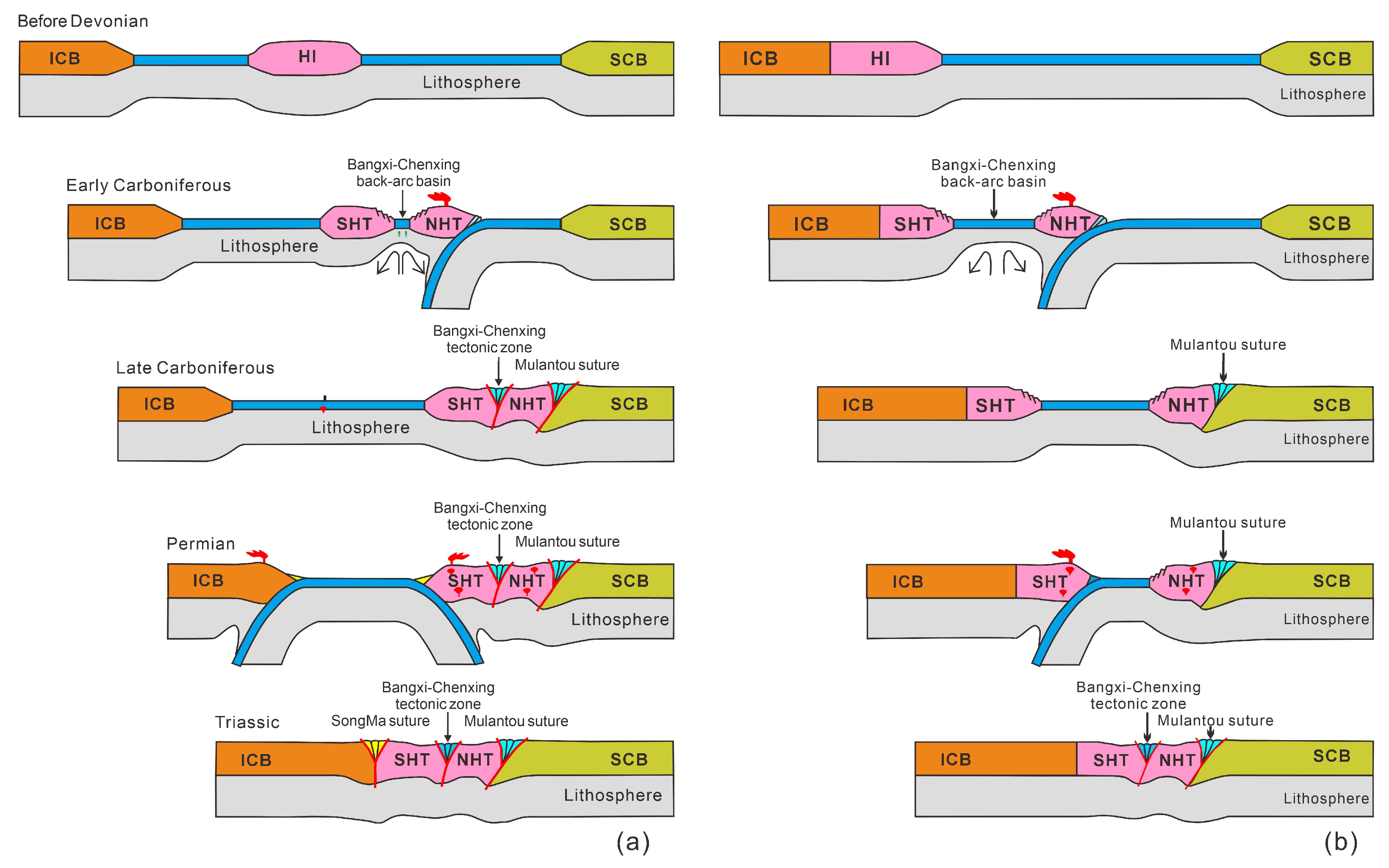
On the basis of the above analysis, a bidirectional subduction model and a unidirectional subduction model are adopted to explain the accretion of Hainan Island to South China [11]. In the bidirectional subduction model (Figure 8a), oceans separated Hainan Island from Indochina and South China before the Devonian. In the Early Carboniferous, the southward subduction of the oceanic slab beneath Hainan triggered prograde metamorphism of the subducted oceanic crust and the formation of the Bangxi–Chenxing back-arc basin. In the Late Carboniferous, the collision between Hainan and South China resulted in high-pressure metamorphism along the Mulantou and closure of the back-arc basin. The Triassic collision between Hainan and Indochina, likely due to double-sided subduction of oceanic crust, is evidenced by arc-related magmatic rocks. It is inferred that the Song Ma suture extends south of Hainan Island, and the Triassic amphibolite facies metamorphism in the Mulantou area is a far-field response. In the unidirectional subduction model (Figure 8b), Hainan Island is part of the Indochina block. The Carboniferous events did not close the Bangxi–Chenxing back-arc basin, which persisted until the Middle Triassic. In summary, the accretion of Hainan Island to South China started in the Late Carboniferous and was completed in the Triassic.

6. Conclusions

On the basis of an investigation of the relationships among topographic relief, gravity anomalies, and magnetic anomalies between Hainan Island and South China, we find that Hainan Island correlates well with South China by moving 230 km to the northwest in the Beibu Gulf Basin. The results confirm that Hainan Island and South China were connected in the Cretaceous. The sedimentary strata of the Beibu Gulf and the Qiongdongnan Basin indicate that Hainan Island was rifted from South China from the Palaeocene to the Oligocene. The breakup of Hainan Island from South China can be explained by the escape tectonics of the Indochina block caused by the India–Asia collision. More evidence from petrology, stratigraphy, paleontology, and paleomagnetism will help to further constrain the process of Hainan Island rifting away from South China, which is also of great significance for investigating the evolution of the South China Sea.

Author Contributions

Conceptualization and methodology, M.W.; software, W.Z.; validation, Y.Z. and Q.L.; formal analysis, Y.Y.; investigation, H.Z.; writing—original draft preparation, M.W. and Y.Z.; writing—review and editing, Q.L. All authors have read and agreed to the published version of the manuscript.

Funding

This study is supported by the National Natural Science Foundation of China (92158208, 42406062); the Natural Science Projects of Colleges and Universities in Anhui Province (2022AH051387, 2024AH051826); the Doctoral Research Startup Fund Project (2025BSK016); and the Key Laboratory of Marine Mineral Resources, Ministry of Natural Resources (KLMMR-2022-G05).

Data Availability Statement

The data that support the findings of this study are available from the corresponding authors upon reasonable request.

Conflicts of Interest

The authors declare no conflicts of interest.

References

  1. Metcalfe, I. Gondwanaland dispersion, Asian accretion and evolution of eastern Tethys. Aust. J. Earth Sci. 1996, 43, 605–623. [Google Scholar] [CrossRef]
  2. Metcalfe, I. Multiple Tethyan ocean basins and orogenic belts in Asia. Gondwana Res. 2021, 100, 87–130. [Google Scholar] [CrossRef]
  3. Ren, H.; Hu, J.; Li, S.; Zhou, D.; Somerville, I.; Wang, L.; Liu, Y.; Suo, Y.; Yu, S.; Wang, X. Early Palaeozoic affinity of Hainan Island to Gondwana: New clues from metamorphic monazite and titanite of the Baoban Complex. Lithos 2024, 482, 107708. [Google Scholar] [CrossRef]
  4. Metcalfe, I.; Shergold, I.H.; Li, Z.X. Gondwana dispersion and Asian accretion: Field work on Hainan Island. Episodes 1993, 16, 443–447. [Google Scholar]
  5. Li, Z.X.; Metcalfe, I.; Wang, X. Vertical-axis block rotations in southwestern China since the Cretaceous: New Paleomagnetic results from Hainan Island. Geophys. Res. Lett. 1995, 22, 3071–3074. [Google Scholar] [CrossRef]
  6. Zhou, D.; Ru, K.; Chen, H. Kinematics of Cenozoic extension on the South China Sea continental margin and its implications for the tectonic evolution of the region. Tectonophysics 1995, 251, 161–177. [Google Scholar] [CrossRef]
  7. Zhou, D.; Sun, Z.; Chen, H.; Xu, H.; Wang, W.; Pang, X.; Cai, D.; Hu, D. Mesozoic paleogeography and tectonic evolution of South China Sea and adjacent areas in the context of Tethyan and Paleo-Pacific interconnections. Isl. Arc 2008, 17, 186–207. [Google Scholar] [CrossRef]
  8. Clift, P.; Lin, J. Preferential mantle lithospheric extension under the South China margin. Mar. Pet. Geol. 2001, 18, 929–945. [Google Scholar] [CrossRef]
  9. Hall, R. Cenozoic geological and plate tectonic evolution of SE Asia and the SW Pacific: Computer-based reconstructions, model and animations. J. Asian Earth Sci. 2002, 20, 353–431. [Google Scholar] [CrossRef]
  10. Li, X.; Zhou, H.; Chung, S.; Ding, S.; Liu, Y.; Lee, C.; Ge, W.; Zhang, Y.; Zhang, R. Geochemical and Sm-Nd isotopic characteristics of metabasites from central Hainan Island, South China and their tectonic significance. Isl. Arc 2002, 11, 193–205. [Google Scholar] [CrossRef]
  11. Liu, X.; Chen, Y.; Wang, W.; Xia, M.; Hu, J.; Li, Y.; Hu, D.; Song, B. Carboniferous eclogite and garnet–omphacite granulite from northeastern Hainan Island, South China: Implications for the evolution of the eastern Palaeo-Tethys. J. Metamorph. Geol. 2021, 39, 101–132. [Google Scholar] [CrossRef]
  12. Jia, L.; Wei, Y.; Zhang, L.; Xu, G.; Liang, D.; Wang, C.; Yang, X.; Ma, X.; Sun, D.; Hu, D. Holocene evolution of the Qiongzhou Strait between Hainan Island and mainland China: Evidence from geological drilling. Palaeogeogr. Palaeoclimatol. Palaeoecol. 2025, 675, 113064. [Google Scholar] [CrossRef]
  13. Zhao, G.; Cawood, P.A.; Li, S.; Wilde, S.A.; Sun, M.; Zhang, J.; He, Y.; Yin, C. Amalgamation of the North China Craton: Key issues and discussion. Precambrian Res. 2012, 222, 55–76. [Google Scholar] [CrossRef]
  14. Faure, M.; Lepvrier, C.; Nguyen, V.V.; Vu, T.V.; Lin, W.; Chen, Z.C. South China block-Indochina collision: Where, when, and how? J. Asian Earth Sci. 2014, 79, 260–274. [Google Scholar] [CrossRef]
  15. Li, Q.; Lin, W.; Wang, Y.; Faure, M.; Meng, L.; Wang, H.; Nguyen, V.V.; Luong Thi Thu, H.; Lepvrier, C.; Chu, Y. Detrital zircon U-Pb age distributions and Hf isotopic constraints of the Ailaoshan-Song Ma Suture Zone and their Palaeogeographic implications for the Eastern Paleo-Tethys evolution. Earth Sci. Rev. 2021, 221, 103789. [Google Scholar] [CrossRef]
  16. Zhou, Y.; Sun, S.; Feng, Z.; Xu, C.; Cai, Y.; Liang, X.; Liu, X.; Du, Y. A new insight into the eastern extension of the Proto-Tethyan margin of Gondwana by Early Paleozoic volcanic rocks in South China. Lithos 2021, 398, 106328. [Google Scholar] [CrossRef]
  17. Zhang, H.; Xu, Y.; Cawood, P.A.; Zi, J.; Zhou, J.; Du, Y. Linking the Paleozoic evolution of Hainan Island to Indochina and Australia: Implication for the palaeogeography of the Eastern Tethys Ocean. Tectonophysics 2023, 858, 229882. [Google Scholar] [CrossRef]
  18. Yang, S.; Yu, Z.; Guo, L.; Shi, Y. The division and palaeomagnetism of Hainan Island and plate tectonic significance. J. Nanjing Univ. 1989, 1, 38–46. (In Chinese) [Google Scholar]
  19. Hsü, K.J.; Li, J.; Chen, H.; Wang, Q.; Sun, S.; Şengör, A.M.C. Tectonics of South China: Key to understanding West Pacific geology. Tectonophysics 1990, 183, 9–39. [Google Scholar] [CrossRef]
  20. Xian, H.; Zhang, S.; Li, H.; Xiao, Q.; Chang, L.; Yang, T.; Wu, H. How Did South China Connect to and Separate from Gondwana? New Paleomagnetic Constraints from the Middle Devonian Red Beds in South China. Geophys. Res. Lett. 2019, 46, 7371–7378. [Google Scholar] [CrossRef]
  21. Replumaz, A.; Tapponnier, P. Reconstruction of the deformed collision zone between India and Asia by backward motion of lithospheric blocks. J. Geophys. Res. Solid Earth 2003, 108, 2285. [Google Scholar] [CrossRef]
  22. Liang, G.H. Eight evidences on Hainan Island separating from China’s Beibuwan Gulf with rotation. Acta Geol. Sin. 2013, 87 (Suppl. S1), 73–76. [Google Scholar]
  23. Liang, G.H. A study of the genesis of Hainan Island. Geol. China 2018, 45, 693–705. [Google Scholar]
  24. Cai, J.X.; Zhang, K.J. A new model for the Indochina and South China collision during the Late Permian to the Middle Triassic. Tectonophysics 2009, 467, 35–43. [Google Scholar] [CrossRef]
  25. Faure, M.; Lin, W.; Chu, Y.; Lepvrier, C. Triassic tectonics of the southern margin of South China Block. Comptes Rendus Geosci. 2016, 348, 5–14. [Google Scholar] [CrossRef]
  26. Yu, J.; Mao, J.; Chen, F.; Wang, Y.; Che, L.; Wang, T.; Liang, J. Metallogeny of the Shilu Fe–Co–Cu deposit, Hainan Island, South China: Constraints from fluid inclusions and stable isotopes. Ore Geol. Rev. 2014, 57, 351–362. [Google Scholar] [CrossRef]
  27. Lepvrier, C.; Faure, M.; Van, V.N.; Vu, T.V.; Lin, W.; Ta, T.T.; Ta, P.H. North-directed Triassic nappes in northeastern Vietnam (east Bac Bo). J. Asian Earth Sci. 2011, 41, 56–68. [Google Scholar] [CrossRef]
  28. Wang, S.; Mo, Y.; Wang, C.; Ye, P. Paleotethyan evolution of the Indochina Block as deduced from granites in northern Laos. Gondwana Res. 2016, 38, 183–196. [Google Scholar] [CrossRef]
  29. Zhu, R.; Zhao, P.; Zhao, L. Tectonic evolution and geodynamics of the Neo-Tethys Ocean. Sci. China Earth Sci. 2022, 65, 1–24. [Google Scholar] [CrossRef]
  30. Cai, Y.F.; Wang, Y.J.; Cawood, P.A.; Zhang, Y.Z.; Zhang, A.M. Neoproterozoic crustal growth of the Southern Yangtze Block: Geochemical and zircon U-Pb geochronological and Lu–Hf isotopic evidence of Neoproterozoic diorite from the Ailaoshan zone. Precambrian Res. 2015, 266, 137–149. [Google Scholar] [CrossRef]
  31. Cai, Y.F.; Liu, H.C.; Feng, Z.H.; Zhou, Y.; Liu, X.J.; Wang, Z.L.; Ma, L.Y.; Li, Z.L.; Xu, J.F. Neoproterozoic active margin of the SW South China Block: Constraints from U-Pb ages, Sr-Nd isotopes and geochemical data for the gabbro and granodiorite along the Ailaoshan tectonic belt. Lithos 2020, 358–359, 105387. [Google Scholar] [CrossRef]
  32. Wu, X.; Hu, J.; Chen, L.; Liu, L.; Liu, L. Paleogene India-Eurasia collision constrained by observed plate rotation. Nat. Commun. 2023, 14, 7272. [Google Scholar] [CrossRef]
  33. Tapponnier, P.; Peltzer, G.; Le Dain, A.Y.; Armijo, R.; Cobbold, P. Propagating extrusion tectonics in Asia: New insights from simple experiments with plasticine. Geology 1982, 10, 611–616. [Google Scholar] [CrossRef]
  34. Tapponnier, P.; Lacassin, R.; Leloup, P.H.; Schärer, U.; Zhong, D.; Wu, H.; Liu, X.; Ji, S.; Zhang, L.; Zhong, J. The Ailao Shan/Red River metamorphic belt: Tertiary left-lateral shear between Indochina and South China. Nature 1990, 343, 431–437. [Google Scholar] [CrossRef]
  35. Li, L.; Lu, S.; Gao, R.; Lei, C. Seismic reflection imaging of a deep-penetrating Red River fault in the Yinggehai basin, northwest of the South China Sea. Geophys. Res. Lett. 2023, 50, e2023GL104598. [Google Scholar] [CrossRef]
  36. Wang, Y.; Lin, W.; Faure, M.; Lepvrier, C.; Chu, Y.; Nguyen, V.V.; Thu, H.L.T.; Wei, W.; Liu, F.; Vu, T.V. Detrital Zircon U-Pb Age Distribution and Hf Isotopic Constraints from the Terrigenous Sediments of the Song Chay Suture Zone (NE Vietnam) and Their Palaeogeographic Implications on the Eastern Paleo-Tethys Evolution. Tectonics 2021, 40, e2020TC006611. [Google Scholar] [CrossRef]
  37. Wang, Y.; Lin, W.; Faure, M.; Nguyen, V.V.; Meng, L.; Chu, Y.; Wei, W.; Thu, H.L.T.; Lepvrier, C.; Vu, T.V.; et al. Correlation among the Ailaoshan–Song Ma–Song Chay orogenic belts and implications for the evolution of the eastern Paleo-Tethys Ocean. Tectonophysics 2022, 843, 229618. [Google Scholar] [CrossRef]
  38. Lin, W.; Liu, F.; Wang, Y.; Meng, L.; Faure, M.; Chu, Y.; Van Nguyen, V.; Wu, Q.; Wei, W.; Thu, H.L.T.; et al. Temporal and spatial heterogeneity of the Ailaoshan–Song Ma–Song Chay ophiolitic mélange, and its significance on the evolution of Paleo-Tethys. Comptes Rendus Geosci. 2024, 356, 115–136. [Google Scholar] [CrossRef]
  39. Yang, L.; Ren, J.; McIntosh, K.; Meng, L.; Faure, M.; Chu, Y.; Nguyen, V.V.; Wu, Q.; Wei, W.; Thu, H.L.T.; et al. The structure and evolution of deepwater basins in the distal margin of the northern South China Sea and their implications for the formation of the continental margin. Mar. Pet. Geol. 2018, 92, 234–254. [Google Scholar] [CrossRef]
  40. Liu, Y.; Wu, Z.; Liu, L.; Yan, S.; Hu, L.; Ping, M.; Zhang, M. Cenozoic structure and tectonics of north subbasins in Beibu Gulf basin, northern South China Sea. Tectonophysics 2021, 812, 228912. [Google Scholar] [CrossRef]
  41. Wu, T.; Pei, J.; Fu, Y.; Deng, D.; Chen, G.; Xu, T.; Wang, D.; Zhou, Z.; Wang, W. The Red River Fault zone and its deep structural characteristics revealed by high-resolution seismic data in the Yinggehai Basin, South China Sea. J. Struct. Geol. 2025, 198, 105457. [Google Scholar] [CrossRef]
  42. Zhao, J.; Liu, C.; Zhao, J.; Xu, Q. Reconstruction of the Cenozoic Deformation of the Yinggehai Basin and Beibu Gulf Basin, South China Sea. J. Mar. Sci. Eng. 2025, 13, 322. [Google Scholar] [CrossRef]
  43. Hu, Y.; Hao, M.; Ji, L.; Song, S. Three-dimensional crustal movement and the activities of earthquakes, volcanoes and faults in Hainan Island, China. Geodesy Geodyn. 2016, 7, 284–294. [Google Scholar] [CrossRef]
  44. Liu, X.; Hu, J.; Chen, L.; Xia, M.; Han, J.; Hu, D. The Mulantou metamorphic complex from northeastern Hainan Island, South China: Compositions, ages and tectonic implications. Acta Geol. Sin. 2022, 96, 3051–3083. [Google Scholar]
  45. Zhou, Y.; Yan, Y.; Liu, H.; Cai, J.; Zhou, M.; Zhang, X.; Wang, Y.; Shen, B. U-Pb isotope geochronology of syntectonic granites from Hainan Island, South China: Constraints on tectonic evolution of the eastern Paleo-Tethys ocean. J. Ocean Univ. China 2020, 19, 1315–1330. [Google Scholar] [CrossRef]
  46. Xu, Z.J.; Gao, S.Y.; Kong, J.T.; Cheng, R. Response of Permian sediment provenance conversion in Hainan Island to the closure of the Eastern Paleo-Tethys Ocean. Aust. J. Earth Sci. 2024, 71, 847–862. [Google Scholar] [CrossRef]
  47. Li, X.; Li, Z.; Li, W.; Wang, Y. Initiation of the Indosinian orogeny in South China: Evidence for a Permian magmatic arc on Hainan Island. J. Geol. 2006, 114, 341–353. [Google Scholar] [CrossRef]
  48. Yan, Q.; Metcalfe, I.; Shi, X. U-Pb isotope geochronology and geochemistry of granites from Hainan Island (northern South China Sea margin): Constraints on late Paleozoic-Mesozoic tectonic evolution. Gondwana Res. 2017, 49, 333–349. [Google Scholar] [CrossRef]
  49. He, H.; Wang, Y.; Cawood, P.A.; Qian, X.; Zhang, Y.; Zhao, G. Permo–Triassic granitoids, Hainan Island, link to Paleotethyan not Paleopacific tectonics. Bull. Geol. Soc. Am. 2020, 132, 2067–2083. [Google Scholar] [CrossRef]
  50. Yin, Z.; Lu, X.; Huang, Q.; Zheng, H.; Cai, Z.; Hua, Y.; Zhang, C.; Deng, F.; Xie, A. Petrogenesis and tectonic implications of late Permian and Triassic granitoids on Hainan Island, South China. Geol. J. 2022, 57, 1837–1849. [Google Scholar] [CrossRef]
  51. Liu, J.Q.; Ren, Z.Y.; Nichols, A.R.L.; Song, M.S.; Qian, S.P.; Zhang, Y.; Zhao, P.P. Petrogenesis of Late Cenozoic basalts from North Hainan Island: Constraints from melt inclusions and their host olivines. Geochim. Cosmochim. Acta 2015, 152, 89–121. [Google Scholar] [CrossRef]
  52. Wang, X.C.; Li, Z.X.; Li, X.H.; Li, J.; Liu, Y.; Long, W.; Zhou, J.; Wang, F. Temperature, pressure, and composition of the mantle source region of Late Cenozoic basalts in Hainan Island, SE Asia: A consequence of a young thermal mantle plume close to subduction zones? J. Petrol. 2012, 53, 177–233. [Google Scholar] [CrossRef]
  53. Zhao, D.; Toyokuni, G.; Kurata, K. Deep mantle structure and origin of Cenozoic intraplate volcanoes in Indochina, Hainan and South China Sea. Geophys. J. Int. 2021, 225, 572–588. [Google Scholar] [CrossRef]
  54. Xia, B.D.; Yu, J.H.; Fang, Z.; Wang, C.Y.; Shi, G.Y. The Carboniferous bimodal volcanic rocks in Hainan Island and their plate tectonic setting. Acta Petrol. Sin. 1991, 7, 54–62. [Google Scholar] [CrossRef]
  55. Tang, H. Geochemical characteristics of the basalt from Chenxing, Hainan Island, and their tectonic implication. Geotecton. Metallogenia 1999, 23, 323–327. [Google Scholar]
  56. Li, X.; Zhou, H.; Ding, S.; Lee, C.; Zhang, R.; Zhang, Y.; Ge, W. Sm-Nd isotopic constraints on the age of the Bangxi-chenxing ophiolite in Hainan Island: Implications for the tectonic evolution of eastern Paleo-Tethys. Acta Petrol. Sin. 2000, 16, 425–432. [Google Scholar]
  57. Fu, L.L.; Shen, Z.Y.; He, L.; Chen, X.G.; Tan, L.M.; Yang, S.F. Cretaceous paleomagnetic results from Hainan Island and its tectonic implications. Acta Geol. Sin. 2010, 84, 183–194. (In Chinese) [Google Scholar]
  58. Liu, Y.Y.; Morinaga, H. Cretaceous palaeomagnetic results from Hainan Island in south China supporting the extrusion model of Southeast Asia. Tectonophysics 1999, 301, 133–144. [Google Scholar] [CrossRef]
  59. Shu, L.; Yao, J.; Wang, B.; Faure, M.; Charvet, J.; Chen, Y. Neoproterozoic plate tectonic process and Phanerozoic geodynamic evolution of the South China Block. Earth Sci. Rev. 2021, 216, 103596. [Google Scholar] [CrossRef]
  60. Whittaker, A.C. How do landscapes record tectonics and climate? Lithosphere 2012, 4, 160–164. [Google Scholar] [CrossRef]
  61. Allen, P.A. From landscapes into geological history. Nature 2008, 451, 274–276. [Google Scholar] [CrossRef]
  62. Whipple, K.X. The influence of climate on the tectonic evolution of mountain belts. Nat. Geosci. 2009, 2, 97–104. [Google Scholar] [CrossRef]
  63. Armitage, J.J.; Duller, R.A.; Whittaker, A.C.; Allen, P.A. Transformation of tectonic and climatic signals from source to sedimentary archive. Nat. Geosci. 2011, 4, 231–235. [Google Scholar] [CrossRef]
  64. Bahadori, A.; Holt, W.E.; Feng, R.; Austermann, J.; Loughney, K.M.; Salles, T.; Moresi, L.; Beucher, R.; Lu, N.; Flesch, L.M. Coupled influence of tectonics, climate, and surface processes on landscape evolution in southwestern North America. Nat. Commun. 2022, 13, 4437. [Google Scholar] [CrossRef] [PubMed]
  65. Shen, Z.K.; Lü, J.; Wang, M.; Bürgmann, R. Contemporary crustal deformation around the southeast borderland of the Tibetan Plateau. J. Geophys. Res. Solid Earth 2005, 110, B11409. [Google Scholar] [CrossRef]
  66. Ellis, M.A.; Barnes, J.B. A global perspective on the topographic response to fault growth. Geosphere 2015, 11, 1008–1023. [Google Scholar] [CrossRef]
  67. Ebinger, C.J.; Keir, D.; Bastow, I.D.; Whaler, K.; Hammond, J.O.S.; Ayele, A.; Miller, M.S.; Tiberi, C.; Hautot, S. Crustal structure of active deformation zones in Africa: Implications for global crustal processes. Tectonics 2017, 36, 3298–3332. [Google Scholar] [CrossRef]
  68. Morley, C.K.; Wang, Y. The Cenozoic hyper-oblique collision zone of Indochina: A re-appraisal of escape tectonics. Earth Sci. Rev. 2023, 243, 104453. [Google Scholar] [CrossRef]
  69. Smith, W.H.F.; Sandwell, D.T. Global sea floor topography from satellite altimetry and ship depth soundings. Science 1997, 277, 1956–1962. [Google Scholar] [CrossRef]
  70. Sandwell, D.T.; Müller, R.D.; Smith, W.H.F.; Garcia, E.; Francis, R. New global marine gravity model from CryoSat-2 and Jason-1 reveals buried tectonic structure. Science 2014, 346, 65–67. [Google Scholar] [CrossRef]
  71. Lesur, V.; Hamoudi, M.; Choi, Y.; Dyment, J.; Thébault, E. Building the second version of the world digital magnetic anomaly map (WDMAM). Earth Planets Space 2016, 68, 27. [Google Scholar] [CrossRef]
  72. Ren, J.; Niu, B.; Wang, J.; He, Z.; Jin, X.; Xie, L.; Zhao, L.; Liu, R.; Jiang, X.; Li, S.; et al. 1.5 Million International Geological Map of Asia. Acta Geosci. Sin. 2013, 34, 24–30. [Google Scholar]
  73. Zhu, H. Biogeographical evidences help revealing the origin of Hainan Island. PLoS ONE 2016, 11, e0151941. [Google Scholar] [CrossRef]
  74. Tapponnier, P.; Peltzer, G.; Armijo, R. On the mechanics of the collision between India and Asia. Geol. Soc. Lond. Spec. Publ. 1986, 19, 113–157. [Google Scholar] [CrossRef]
  75. Peltzer, G.; Tapponnier, P. Formation and evolution of strike-slip faults, rifts, and basins during the India-Asia collision: An experimental approach. J. Geophys. Res. Solid Earth 1988, 93, 15085–15117. [Google Scholar] [CrossRef]
  76. Zheng, Y.F. A revisit to continental collision between India and Asia. Earth Sci. Rev. 2025, 264, 105087. [Google Scholar] [CrossRef]
  77. Clark, M.K.; Royden, L.H. Topographic ooze: Building the eastern margin of Tibet by lower crustal flow. Geology 2000, 28, 703–706. [Google Scholar] [CrossRef]
  78. Duan, L.; Meng, Q.R.; Wu, G.L.; Yang, Z.; Wang, J.; Zhan, R. Nanpanjiang basin: A window on the tectonic development of south China during Triassic assembly of the southeastern and eastern Asia. Gondwana Res. 2020, 78, 189–209. [Google Scholar] [CrossRef]
  79. Faure, M.; Lin, W.; Chu, Y.; Lepvrier, C. Triassic tectonics of the Ailaoshan belt (SW China), Early Triassic collision between South China and Indochina blocks, and Middle Triassic intracontinental shearing. Tectonophysics 2016, 683, 27–42. [Google Scholar] [CrossRef]
  80. Zhu, W.; Mi, L. Atlas of Oil and Gas Basins in the Waters of China; Petroleum Industry Press: Beijing, China, 2010. [Google Scholar]
  81. Shen, L.; Yu, J.; O’Reilly, S.Y.; Griffin, W.L.; Zhou, X. Subduction-related middle Permian to early Triassic magmatism in central Hainan Island, South China. Lithos 2018, 318, 158–175. [Google Scholar] [CrossRef]
  82. Keppie, D.F. How the closure of paleo-Tethys and Tethys oceans controlled the early breakup of Pangaea. Geology 2015, 43, 335–338. [Google Scholar] [CrossRef]
  83. Lepvrier, C.; Maluski, H.; Van Vuong, N.; Roques, D.; Axente, V.; Rangin, C. Indosinian NW-trending shear zones within the Truong Son belt (Vietnam): 40Ar-39Ar Triassic ages and Cretaceous to Cenozoic overprints. Tectonophysics 1997, 283, 105–127. [Google Scholar] [CrossRef]
  84. Lepvrier, C.; Vuong, V.N.; Maluski, H.; Thi Phan, T.T.; Tich, V.V. Indosinian tectonics in Vietnam. Comptes Rendus Geosci. 2008, 340, 94–111. [Google Scholar] [CrossRef]
  85. Carter, A.; Clift, P.D. Was the Indosinian orogeny a Triassic mountain building or a thermotectonic reactivation event? Comptes Rendus Geosci. 2008, 340, 83–93. [Google Scholar] [CrossRef]
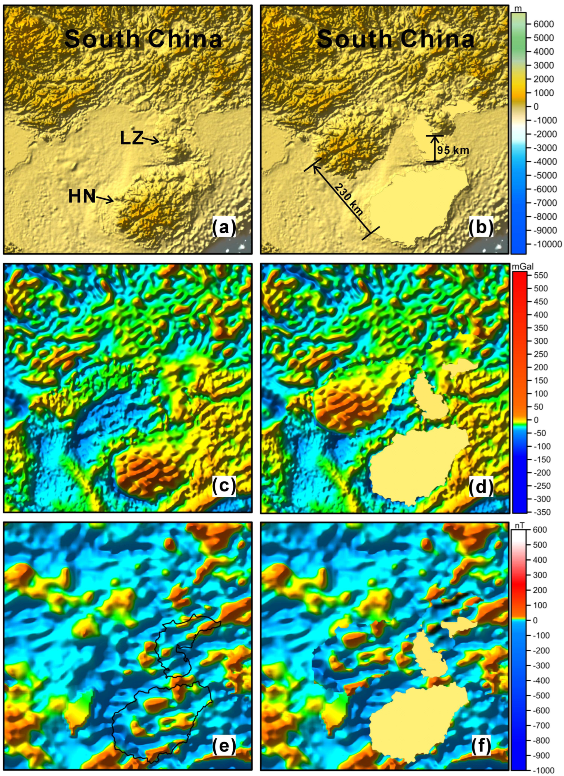
Figure 3. (a,b) Modern and reconstructed topographic position, respectively. (c,d) Modern and reconstructed gravity anomalies, respectively. (e,f) Modern and reconstructed magnetic anomalies, respectively. HN: Hainan Island, LZ: Leizhou Peninsula.
Jmse 13 01681 g003
Figure 4. (ac) E-W, NE-SW, and N-S continuous tectonic lines on topographic relief, respectively. (df) E-W, NE-SW, and N-S continuous tectonic lines on gravity anomalies, respectively. (gi) E-W, NE-SW, and N-S continuous tectonic lines on magnetic anomalies, respectively.
Jmse 13 01681 g004
Figure 5. Modern and reconstructed geological maps of Hainan Island and its adjacent areas. (a,b) Modern and reconstructed Permian granite distribution, respectively. (c,d) Modern and reconstructed Triassic granite distribution, respectively. (e,f) Modern and reconstructed Cretaceous strata distribution, respectively [72].
Jmse 13 01681 g005
Figure 6. The Indo-Eurasian collision caused Hainan Island to break apart from South China [32]. (a) The initial stage of the collision of India and Eurasia. (b) The post-collision scheme of India and Eurasia. SC: South China block, IC: Indochina block, SB: Sibumasu block, SG: Songpan–Ganzi, QT: Qiangtang, LT: Lhasa terrane, KL: Kohistan–Ladakh arc, SCS: South China Sea, WR: Wharton Ridge, CR: Carlsberg Ridge, CFZ: Chain Fracture Zone.
Jmse 13 01681 g006
Figure 7. (a) Geological structure profile corresponding to L1 of Beibu Gulf Basin. (b) Geological structure profile corresponding to L2 of Qiongdongnan Basin [80]. The location of the profiles L1 and L2 is shown in Figure 1a.
Jmse 13 01681 g007
Figure 8. The paleodynamic reconstruction of Hainan and South China [11]. (a) Bidirectional subduction collage model. (b) Unidirectional subduction collage model.
Jmse 13 01681 g008
Disclaimer/Publisher’s Note: The statements, opinions and data contained in all publications are solely those of the individual author(s) and contributor(s) and not of MDPI and/or the editor(s). MDPI and/or the editor(s) disclaim responsibility for any injury to people or property resulting from any ideas, methods, instructions or products referred to in the content.