Article

Sedimentary Characteristics and Genetic Mechanisms of Non-Evaporitic Gypsum in a Half-Graben Basin: A Case Study from the Zhanhua Sag, Bohai Bay Basin, China

1
School of Energy Resources, China University of Geosciences (Beijing), Beijing 100083, China
2
Research Institute of Petroleum Exploration and Development, Sinopec Shengli Oil Field Company, Dongying 257015, China
*
Author to whom correspondence should be addressed.
J. Mar. Sci. Eng. 2025, 13(7), 1300; https://doi.org/10.3390/jmse13071300
Submission received: 25 May 2025 / Revised: 26 June 2025 / Accepted: 30 June 2025 / Published: 2 July 2025
(This article belongs to the Section Geological Oceanography)

Abstract

Gypsum and salt rocks have been proven to act as seals for abundant oil and gas reserves on a global scale, with significant potential for hydrocarbon preservation and evolution. Notably, the sedimentary dynamics of non-evaporitic gypsum in terrestrial half-graben basins remain underexplored, particularly regarding its genetic link to hydrocarbon accumulation in interbedded mudstones. This study is based on the Zhanhua Sag, in which thick-layered gypsum rocks with dark mudstone are deposited. The gypsum crystals show the intermittent deposition characteristics. The cumulative thickness of the gypsum-containing section reaches a maximum of over 110 m. The spatial distribution of gypsum thickness correlates strongly with the location of deep-seated faults. The strontium and sulfur isotopes of gypsum indicate deep hydrothermal fluids as mineral sources, and negative oxygen isotope excursions also suggest that gypsum layers precipitated in situ from hot brine. Total organic carbon and Rock-Eval data indicate that the deep-lake gypsum rock system has excellent hydrocarbon potential, especially in the mudstone interlayers. This study developed a depositional model of deep-lake gypsum rocks with thermal brine genesis in half-graben basins. The gypsum-bearing system is rich in mudstone interlayers. These gypsum–mudstone interbeds represent promising targets for shale oil exploration after the initial breakthrough during the extraction process. These insights provide a theoretical framework for understanding gypsum-related petroleum systems in half-graben basins across the globe, offering guidance for hydrocarbon exploration in analogous sedimentary environments.

1. Introduction

Gypsum is common in half-graben basins [1], and megascale deposition exists throughout the Gulf of Mexico [2,3] and the Precaspian Basin [4,5]. Gypsum layers have good sealing properties, which is crucial to note when identifying oil and gas accumulation areas [6,7].
Researchers have proposed various lacustrine gypsum depositional models, such as shallow-water evaporation salinization [8], deep-water halogenation salinization [9], sea intrusion, periphyton percolation, and volcanic activity [1,10], carrying implications both for formation models applicable to oil and gas accumulation, as stated above, but also for diverse applications like paleoenvironmental reconstructions, Mars analog applications, and the evolution of evaporitic deposits and salts through time [11,12,13,14,15,16].
As for the driving force of crystal precipitation, the current view is that evaporation from the water body precipitation primarily exceeds the solubility threshold, leading to precipitation [8,11,12,13]. As gypsum is commonly found in an evaporitic environment, there are a large number of well-known depositional models, such as the typical Sabha model [17,18] and the reflux model [19]. To further study non-evaporitic gypsum, some scholars have proposed a deep-water depositional model [9,20,21]. This model suggests that gypsum was deposited by high-salinity sulfur-rich hot brines formed in a deep-water environment. This method emphasizes ion sources and provides limited explanation of the depositional process and later evolution. It also does not fully reveal the geological significance of gypsum in petroleum exploration. Furthermore, research on the non-evaporitic origin of marine gypsum is becoming increasingly common since this type of precipitate was observed [9,22,23,24,25,26,27,28,29].
In many half-graben basins worldwide, the development of gypsum is interbedded with dark mudstone and carbonate, such as in China’s terrestrial half-graben basins, like the Jiyang Depression [30]. Conventional models of evaporite-originating gypsum and marine gypsum are not able to explain the deposition phenomenon of gypsum coexisting with dark mudstone. Thus, there is a lack of depositional models that can explain the non-evaporitic origin of terrestrial gypsum in dark mud sediments. However, existing studies focus on mineral sources and depositional drivers, and the types of depositional patterns are incomplete; in particular, our understanding of gypsum–mud interbedding is controversial [31,32,33]. In addition to the depositional pattern issue, microscopic observations have revealed the presence of barite, a signature mineral of hydrothermal activity [34,35]. Given that barite formation in continental basins is often associated with hydrothermal brine seeps [36], it implies a potential hydrothermal-related origin for gypsum in these half-graben basins. Beyond its role as a sealing rock [37], gypsum may possess undiscovered hydrocarbon system relevance, including potential source rock association and reservoir quality modification. Therefore, further research is needed to elucidate the material source and formation mechanism of gypsum, as well as its hydrocarbon geological significance.
This study aims to improve the understanding of the depositional system of gypsum in half-graben basins and to provide a scientific basis for the exploration of terrestrial shale oil of the gypsum–mudstone interlayer type. To achieve this, we used the upper fourth member of the Paleogene Shahejie Formation in the Zhanhua Sag as a case study. We first comprehensively considered the stability and relative certainty of isotopes, selecting sulfur and strontium isotopes to determine the source characteristics of the gypsum formation system and oxygen isotopes to identify the formation period of authigenic gypsum. Using petrological observations and strontium–sulfur–oxygen isotopes, we characterized the hydrothermal brine circulation and anoxic depositional environment. This study further elucidates the sedimentary characteristics and controlling factors of gypsum in the Zhanhua Sag. Additionally, we analyzed the spatial distribution of gypsum and its relationship to hydrothermal pathways, integrating mineral source tracing and depositional modeling. A depositional model of deep-lake gypsum in half-graben basins was also developed. Compiling and analyzing organic geochemical data, we determined the hydrocarbon potential of gypsum-bearing formations.

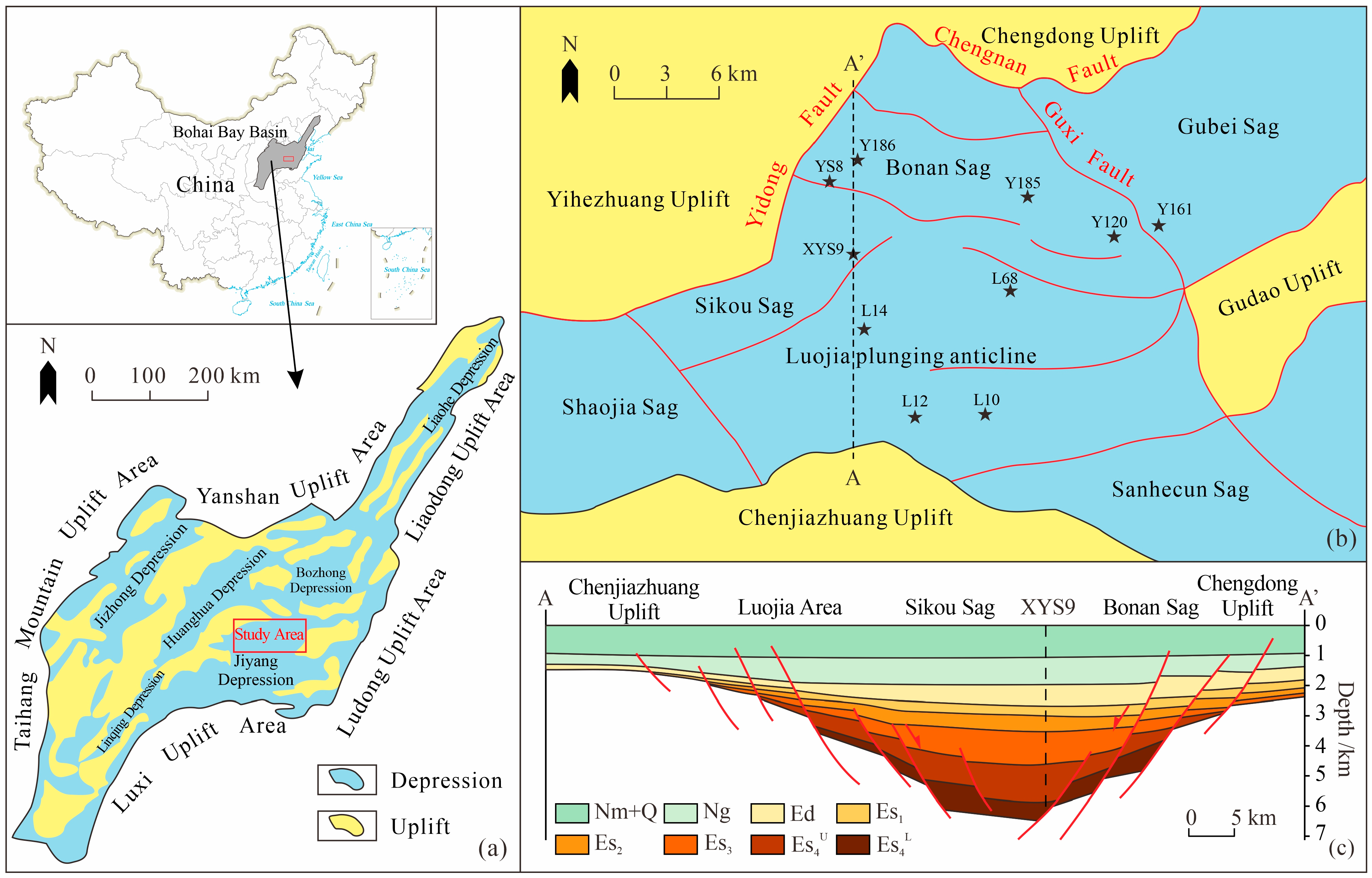
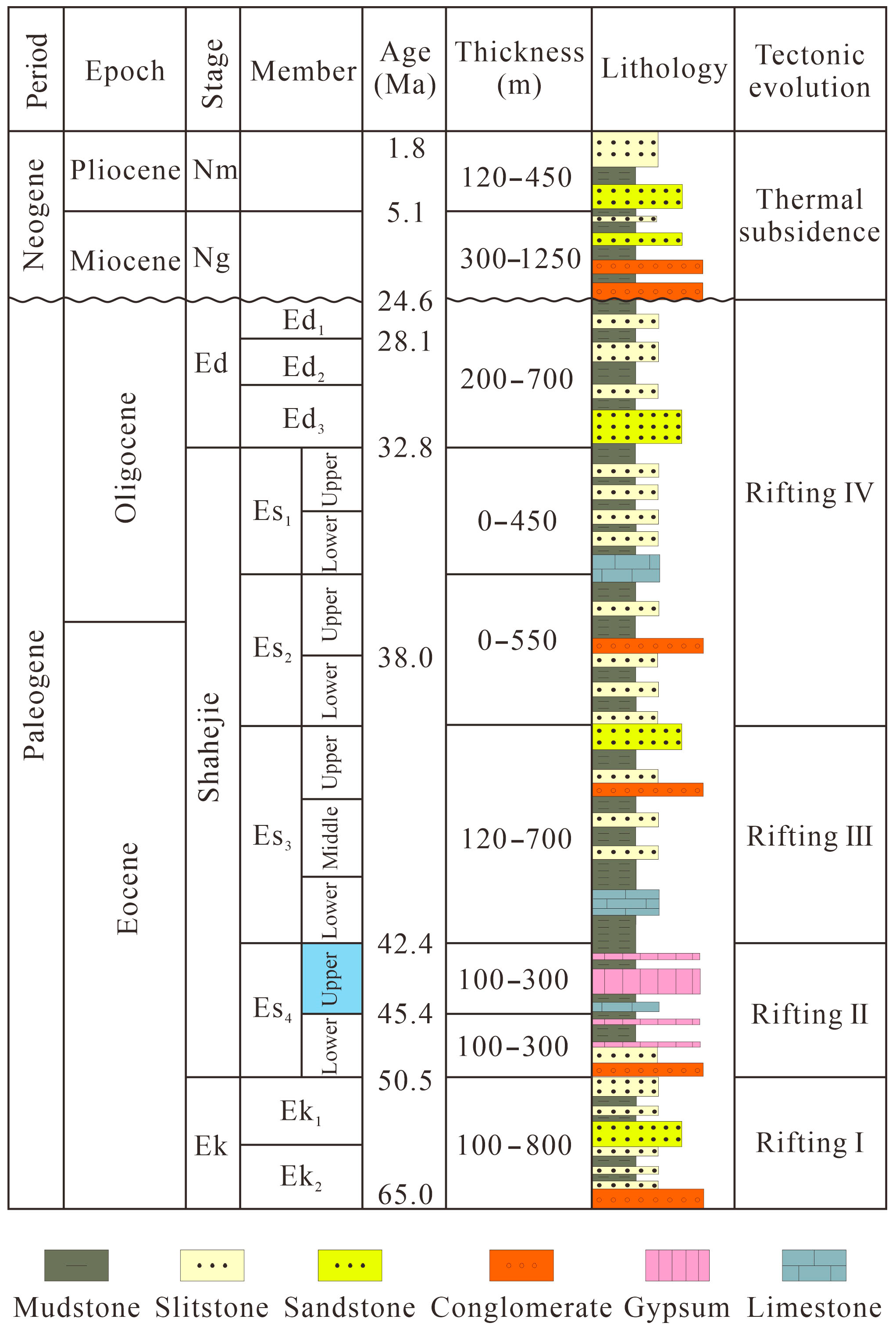
2. Geological Setting

The Zhanhua Sag is located in the northeastern part of the Bohai Bay Basin, covering an area of 2800 km2 [38] (Figure 1a). As a terrestrial half-graben basin with Paleozoic basement, the Zhanhua Sag is an extensional basin. Its formation is mainly controlled by the Indosinian–Yanshan orogenesis [39]. Several NE- and NEE-trending normal faults (e.g., Guxi and Yidong Faults) were created due to the intense tectonic activity (Figure 1b,c).
The Paleogene strata of the Zhanhua Sag include the Kongdian Formation (Ek), Shahejie Formation (Es), and Dongying Formation (Ed) [40]. The Eocene Shahejie Formation includes four members (Es4–Es1), with conformable contact relationships (Figure 2). This study focuses on the upper fourth member of the Shahejie Formation (Es4U). During the depositional period of the Es4U, a series of reverse faults reversed into southeast-trending normal faults, and there was a considerable change in topography, with a maximum tectonic subsidence rate of about 140–100 m/Ma [40]. The main lithologies of the Es4U include clastic rocks, carbonates, gypsum, and mudstone [41]. The lower fourth member of the Paleogene Shahejie Formation is dominated by red-bedded sediments and a few thin layers of gypsum, whereas the lower third member of the formation is dominated by oil shale and dark mudstone.

3. Materials and Methods

The key data are based on cores from 10 wells in the Es4U sub-member of Zhanhua Sag (Figure 1). Strontium isotope (87Sr/86Sr) and sulfur isotope (δ34S) testing were conducted in the Analysis and Testing Research Center of Beijing Geological Research Institute of the Nuclear Industry. The oxygen isotopes, organic geochemical data, and spore/pollen data were tested and provided by the Sinopec Shengli Oilfield Company.

3.1. Thin-Section

Rock samples were polished to a final thickness of 0.03 mm. Coverslips were placed on the sections, and excess resin was removed. A total of 26 thin sections were analyzed under plane-polarized light and cross-polarized light using a Zeiss Axio Imager A2m microscope from Carl Zeiss AG, Oberkochen, Germany.

3.2. Sulfur Isotope Measurement

Natural Sulfur exists in four stable isotopes with different abundances: 95.02% for 32S, 0.76% for 33S, 4.22% for 34S, and 0.0136% for 36S. Because 32S and 34S are the most abundant and easy to analyze, the ratio of the two (δ34S) is commonly used, which is expressed as follows:
δ S 34 = S 34 S 32 S a m / S 34 S 32 S t a 1 × 1000
The sulfur isotope was determined using a Finnigan MAT-251 mass spectrometer (Thermo Fisher Scientific, Waltham, MA, USA) and the testing method of “Determination of Sulfur Isotope Composition of Sulfides” (code: DZ/T 0184.14-1997). The precision and accuracy of δ34S values determined using this method are generally higher than ±0.2%.

3.3. Strontium Isotope Measurement

Natural strontium exists four stable isotopes, namely, 88Sr, 87Sr, 86Sr, and 84Sr, with relative abundances of 82.53%, 7.04%, 9.87%, and 0.56%, respectively [42]. 87Sr is formed by a single β decay of 87Rb, i.e., R b 87 S r 87 + β + γ + E . Therefore, the abundance of 87Sr in strontium isotopes is variable and depends on the Rb/Sr ratio in the Rb-bearing mineral and rock ratio and age. In addition, strontium undergoes slight isotopic fractionation when the salinity and evaporation conditions change. Based on these properties, 87Sr/86Sr ratio is a reliable tracer for studying the origin and migration of ions [43]. Extensive studies have reported that terrigenous input increases the 87Sr/86Sr ratio of lake water, whereas mantle-derived hydrothermal input decreases the 87Sr/86Sr ratio of lake water [44].
For strontium isotope measurement, the core samples were crushed to less than 75 μm (200 mesh) without contamination. Strontium isotope analysis was conducted using a Phoenix thermal surface ionization mass spectrometer (IsotopX, Middlewich, UK) and the testing method from the “Determination of Lead, Strontium, and Neodymium Isotopes in Rocks” (code: GB/T 17672-1999).

3.4. Oxygen Isotope Measurement

Oxygen isotope variations are important indicators of ion sources in the water column [45]. These variations are controlled by both fluid mixing and temperature fractionation effects, mainly dominated by the latter [46]. Under a certain physicochemical state, oxygen isotopes in mineral–water interactions can reach fractionation equilibrium. Hydrothermal action and atmospheric leaching can lead to low oxygen isotopes in sediments [47].
δ18OPDB measurements were determined using a liquid water isotope analyzer (TIWA-45EP) according to the Vienna Standard Mean Ocean Water (VSMOW) standards, with precision of ±0.1‰.

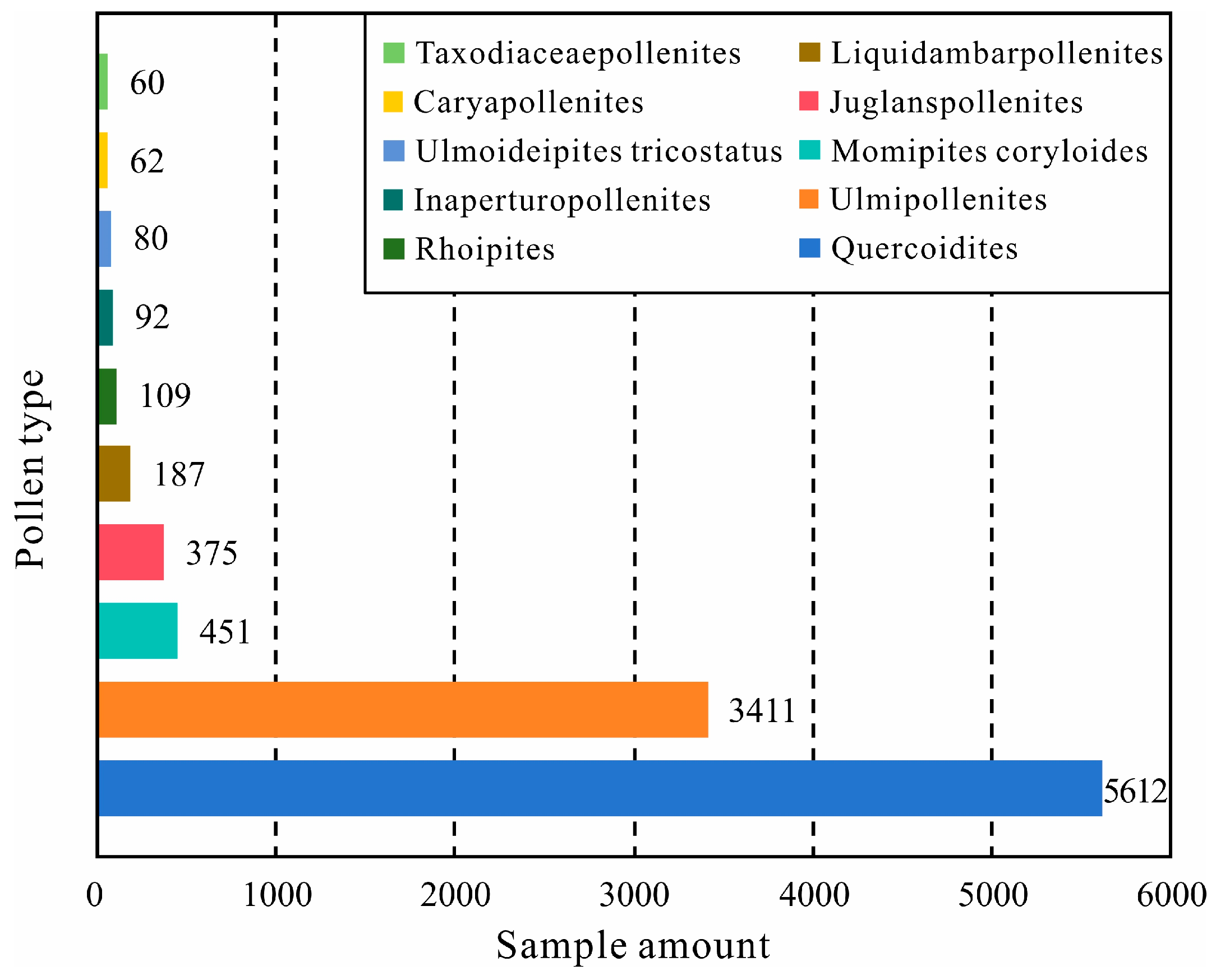
3.5. Palynological Characteristics

Sporopollen extracted from lake sediments are effective indicators for studying paleoclimate changes [48,49]. In this study, the spore and pollen identification results of 16 wells were scientifically counted (329 samples).

4. Results

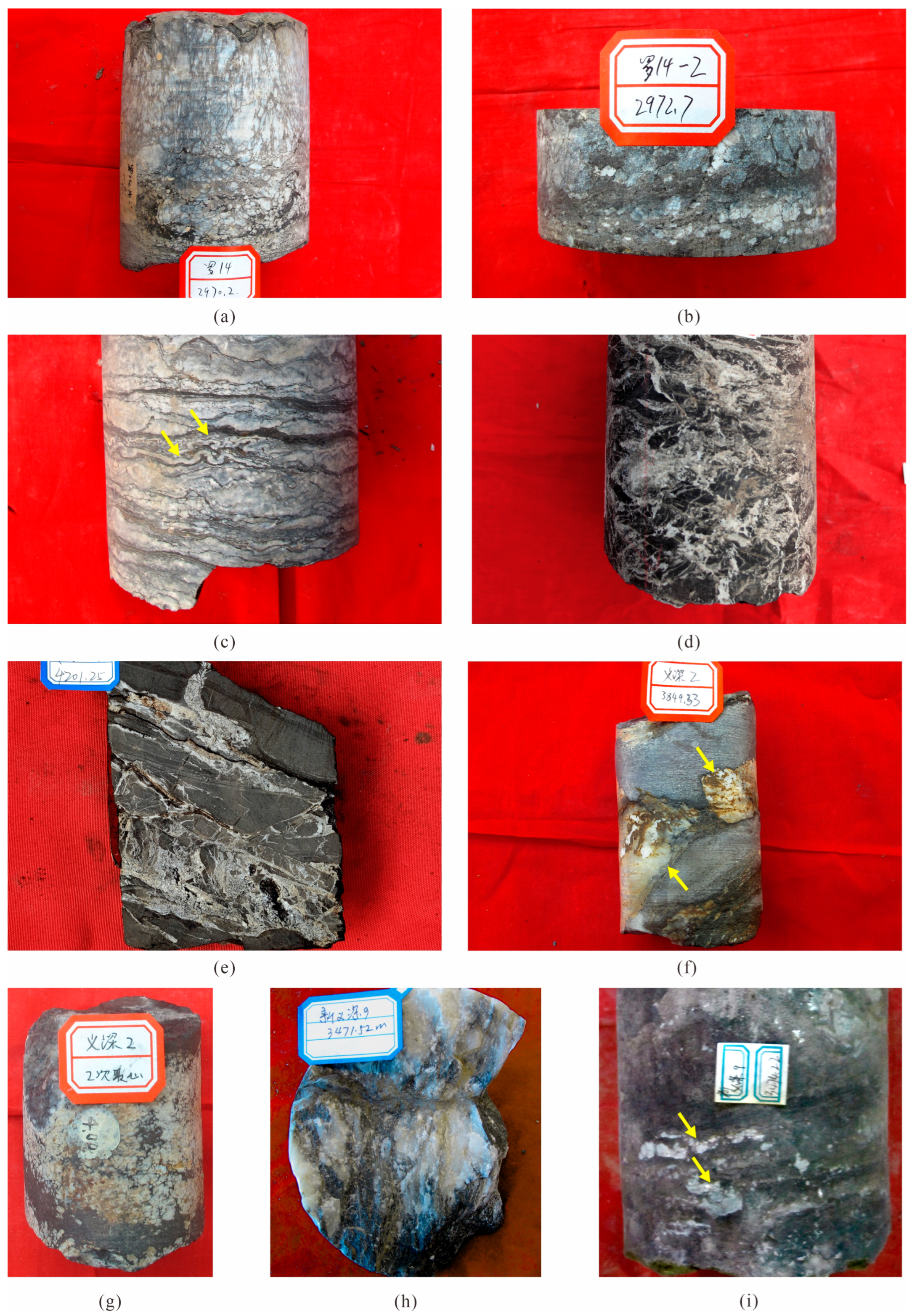
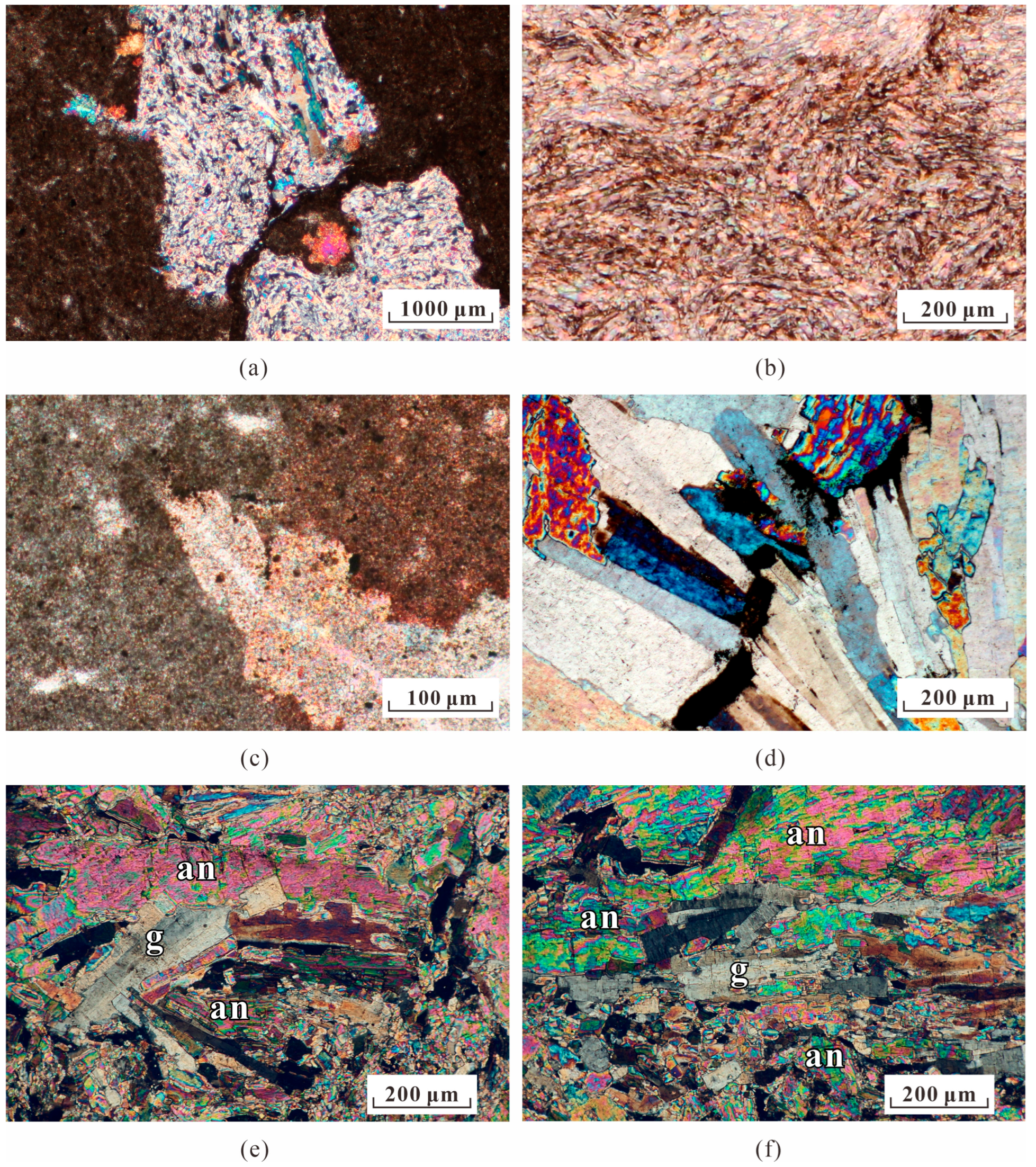
4.1. Petrology Characteristics

According to the core observations, the strata mainly consist of dark mudstone with white nodular or layered gypsum (Figure 3). Most gypsum rocks have enourmous structures and are interspersed with angular muddy debris (Figure 3a,b,f–h). The interbedded section of the gypsum forming elongated nodules and dark mudstone exhibits obvious deformation with unevenness at the boundary (Figure 3c). Some gypsum fills a network of small fractures (Figure 3d,e).
As can be seen through microscope observation, coarse fibrous gypsum and some prismatic gypsum types are produced in irregular patches or veins (Figure 4). There are gypsum veins embedded in the matrix in the gypsum–mud interbedded layers (Figure 4c). The overpressure fractures within the gypsum are haphazardly produced, developing from low to high angles, lacking a certain regularity, exhibiting noticeable bifurcation, and interconnecting to form a large-scale crack network. The length of these cracks can be dozens of centimeters long, filled with asphalt or muddy strips. In general, the cracks have small degrees of openness, typically less than 0.1 cm. Fibrous gypsum and tabular gypsum present an obvious directionality (Figure 4d). The gypsum crystals are engulfed by anhydrite (Figure 4e,f).

4.2. Elemental Geochemical Analysis

4.2.1. Sulfur Isotope

The results of sulfur isotope analysis tests indicate that the δ34S value of gypsum in the Es4U of the Zhanhua Sag, varies from 30.22‰ to 37.60‰, with an average value of 34.62‰ (Table 1). Notably, these values are higher than those of Paleoproterozoic seawater (15–24‰) [50].

4.2.2. Strontium Isotope

The results of the strontium analysis indicate that the 87Sr/86Sr ratio of gypsum varies from 0.709152 to 0.709750, with an average value of 0.709543 (Table 2).

4.2.3. Oxygen Isotope

The results of oxygen isotope analysis tests indicate that the δ18OPDB value of gypsum in the Es4U of the Zhanhua Sag, varies from −13.3‰ to −6.7‰, with an average value of −9.7‰ (Table 3).

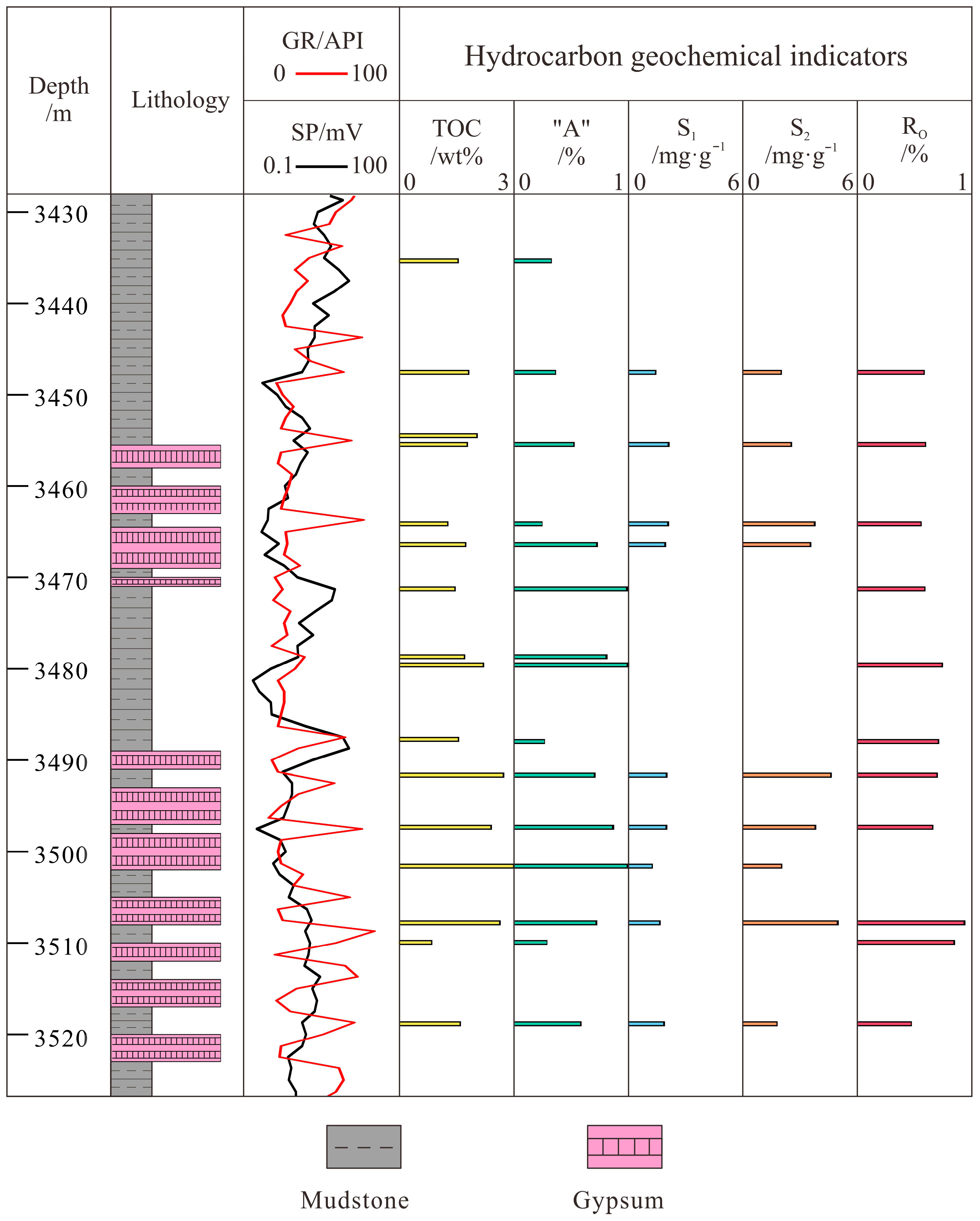
4.3. Organic Geochemical Characteristics

Compiling and analyzing the organic geochemical data of well XYS9, the TOC ranges from 0.88 wt% to 3.15 wt% (avg. 2.35 wt%), S1 + S2 ranges from 2.67 to 7.48 mg HC/g (avg. 5.5 mg HC/g), and RO ranges from 0.5% to 0.98% (avg. 0.75%) (Figure 5). The gypsum-bearing strata have been found to have a higher degree of organic matter evolution and to show stronger hydrocarbon potential than the non-gypsum-bearing strata. In particular, the hydrocarbon indicators of the mud intercalation in the thick gypsum are relatively superior (TOC: 1.25 wt% to 3.15 wt%).

5. Discussion

5.1. Controlling Factors of Gypsum Deposition

5.1.1. Climate

In considering Eocene depositional trends, it also bears noting that global Paleogene climate has been documented to influence marine deposition to varying degrees [51,52,53,54]. During the middle Eocene, the paleoclimate of China transitioned from a pattern of latitudinal precipitation differentiation dominated by westerly winds to a monsoon-controlled pattern with humid conditions in the east and arid conditions in the west [55]. The deposition of the Es4U in the study area was controlled by the East Asian monsoon [56]. The data analyzed from tests such as the spore/pollen humidity index test indicate that the middle and lower parts of the Es4U are in a relatively arid period, but the climate of the upper part of the Es4U changed from arid to hot and humid [57].
According to statistical analysis, the dominant genera of spore and pollen in the Es4U in the Zhanhua Sag are Quercoidites and Ulmipollenites (Figure 6). The study area also contains other types of spore/pollen such as Momipites coryloides, Juglanspollenites, and Liquidambarpollenites. The high content of Quercoidites, Ulmipollenites, and Liquidambarpollenites indicates that the region has warm and humid climates at this stage [58].
Under the warm and humid climate background, it is difficult for gypsum to form through evaporation. Different from the typical evaporation sequence, there is no carbonate–sulfate–halite–sylvite evaporitic sedimentary sequence in the vertical direction in the Es4U in the Zhanhua Sag (Figure 3). Three main sedimentary sequences exist in the gypsum sedimentary section. Type I consists of thick layers of grayish—white gypsum with little dark—gray mudstone interlayers. This type is mostly found in wells at the sedimentation center of the lake basin. Type II sedimentary sequence is characterized by interbedded deposits of gypsum and mudstone with unequal thicknesses, with most of the gypsum dehydrated to anhydrite. This type is widely developed in the study area. Type III sedimentary sequence is composed of lime mudstone and gypsum. This type of sedimentary sequence is generally found in the southern part of the study area in the tectonically gently sloping zone, and the scale of development is small.
The typical evaporation sequences of salt minerals are absent, and the gypsum is coeval with dark mudstones. Based on these sedimentological and lithological observations, in combination with geochemical principles related to redox conditions, it is inferred that the gypsum was precipitated from hot brine within a deep-water reducing environment, where low oxygen levels and specific chemical gradients favored its formation [59].

5.1.2. Salinity Stratification

The mechanism of salinity stratification in the lake basin waters determines that gypsum is mainly deposited in deep water close to tectonic fracture zones, thinning out in all directions. First, the lake water itself induces stratification, which is driven by density differences within the body of water. The temperature exerts a considerable effect on the density of the water. Warmer water is less dense and floats over colder water, given the same salinity [60]. Solar radiation warms the surface lake water, making it less dense than the water below and preventing mixing between the top and bottom, thus causing stratification [61,62]. Only a small temperature difference is required to prevent mixing between layers. The temperature difference needed depends on the surface area, shape, and winds of the lake. Salinity stratification is further exacerbated by the influx of deep hot brine, a highly saline water body, into a low-salinity lake body. Future study of salinity stratification could be augmented by biomarker analysis [63,64,65].
During the period of saline lake deposition in the Es4U in the Zhanhua Sag, the thickness of the developed gypsum rock layer in the sinking center of the lake basin accounted for 30–80% of the total thickness of the strata. The color of the gypsum is mainly white and gray, and the occurrence form is mainly nodular, irregular patches, laminated, etc. The dark mud shale interbedded with it develops horizontal grain layers. The stable stratigraphy of gypsum development, the good layering of mud interlayers, and the lack of exposure markers indicate that the depositional environment of the gypsum in the target section is a deep-water anoxic reducing environment of semi-deep to deep lakes.

5.1.3. Deep Fault System

Gypsum and dark mudstone are seen intruding and tearing each other in core observation, forming a large number of soft-sediment deformation structures (Figure 3). This phenomenon suggests that the gypsum was formed in the deep-water burial stage, when the mudstone had not been compacted and solidified into rock, and the brine intruded through the fracture from the bottom to the top to promote the deposition of gypsum. Simultaneously, the tectonic stress and hydrodynamic force together destroyed the horizontal lamination of the deep-lake-phase mudstone, and the gypsum intertwined with mudstone, forming soft-sediment deformation structures (Figure 3c). Contrarily, if the gypsum is precipitated by ions in the lake water, its deposition should be controlled by the cyclic changes in the depositional environment, and it is difficult to form a large number of syngenetic deformation structures [31]. The gypsum formed by environmental changes in the lake basin water body should be in horizontal contact with the integration of mudstone, forming a laminae-like structure that records frequent changes in the climate rather than the intertwined shape described above [21]. The thin-section at 3000.90 m of well L14 shows that the anhydrite is clumped and composed of stellate-cut grain layers in the mud crystal matrix, indicating the anhydrite is not formed in the synorogenic stage (Figure 4a,c). The gypsum crystals are engulfed by anhydrite (Figure 4e,f). This demonstrates that the process of anhydritization is still in progress, with the rims of the gypsum nodules consisting of anhydrite that has replaced gypsum. This configuration confirms primary gypsum formation followed by partial dehydration, analogous to the “gypsum with anhydrite rind” model built by Amadi et al. [66]. The thin-section at 4176.64 m in well Y186 shows that the size, axial direction, and extinction level of gypsum crystals on both sides of the fracture are inconsistent, suggesting the fracture is contemporaneous with or slightly earlier than the formation of gypsum crystals, which provides an ion transportation channel for the formation of gypsum crystals (Figure 4d).
The burial depth of the Es4U in the Zhanhua Sag is generally 2700–4000 m, with a maximum depth of up to 5 km, in which gypsum is concentrated in the middle and upper parts of the stratigraphic section, with a depth section of about 2800–3600 m [67]. The total stratigraphic thickness of gypsum is the largest in the Bonan sub-sag, in which gypsum–mudstone and gypsum rock are the most developed. The thickness of the gypsum layer can reach up to 10 m in lithology well logging. Combined with the seismic data, it was found that wells close to the fracture zones are characterized by the frequent interbedding of thick gypsum and thinner dark mudstone (with some gypsum) at the meter scale (Figure 7).
Isopach maps were based on core and logging data from 63 exploratory wells (Figure 8). The stratigraphic thickness in the Es4U in the Zhanhua Sag is generally higher than 100 m, with a maximum thickness close to wells YS8 and XYS9 in one area and well YS161 in another (Figure 8a). There are two main depositional centers: one is located in the downthrow of the Guxi Fault, with a maximum thickness of up to 500 m, rapidly pinching out to the northwest; the other is located in the downthrow of the Yidong Fault, with a maximum thickness of up to 600 m, and rapidly pinches out to the east. The two centers gradually thinning toward the Luojia plunging anticline in the southern part of the study area. Combined with the geological background that the study area is a typical single-break lake basin, steep in the north and slow in the south, and it has been observed that the sedimentary center is in the north–central part of the study area and that the fracture zones control the deposition in this period.
Horizontally, the gypsum is mainly deposited in the northern steep-slope zone, and the distributions of the three larger-scale gypsum deposits centered on wells Y186, XYS9, and L68 are connected in the plane. The distribution of the gypsum is elliptical in an east–west direction as a long axis and is thick in the center and thin around the circumference. The maximum thickness of the gypsum-containing section in the area of wells Y186 to XYS9 is more than 110 m. The thickness of the gypsum-containing section on the east side of the area centered on well L68 is approximately 50–80 m, which is less than that in the area of wells Y186 to XYS9 (Figure 8b). The thickness variation in the gypsum layer matches the stratigraphic isothickness map well. It indicates that the gypsum is mainly deposited in the sedimentation center of the lake basin and that the gypsum deposition is closely related to tectonic rupture activities.

5.1.4. Hot Brine

The δ34S values of the target layer section in the study area range from 30.22‰ to 37.60‰, which is higher than 20‰ overall (Table 1). Deep geothermal and magmatic activities lead to sulfur isotope enrichment. The hot brine serves as a finite reservoir of sulfate, providing a sulfur source with high δ34S. Sulfate-reducing bacteria promote isotope fractionation under relatively confined deep-lake environmental conditions [50]. Under the strong reducing effect of deep water, 32S is gradually removed from the deep brackish water of the lake, and δ34S increases. At the same time, sulfate ions are not replenished by open water. Thus, δ34S in the later formed gypsum is also characterized by high values, which exhibit a bottom-up increase in the vertical direction.
The overall 87Sr/86Sr ratio of gypsum in the Es4U is lower than the mean of 0.719 for the continental crust and is close to the 87Sr/86Sr ratio of 0.706 for deep-source hydrothermal fluids of the same period [68]. The data indicate that the gypsum was not formed by terrestrial input but rather evolved from deep fluids (Table 2).
Strontium and sulfur isotopes are important indicators for determining the hydrological characteristics and reconstructing the depositional environment. The isotope data match the signature of upper-mantle-derived fluids, indicating that the hot brine is essentially a mantle-source fluid. The basin sedimentary layers and basement make a limited contribution to the material components of the subsurface fluids. The mixing influence of the crust and sedimentary layers on the properties of the hot brine is negligible.
The negative oxygen isotope excursions suggest that the closed system of the mineral–water reaction was disrupted. The temperature of the sedimentary water body was increased by the intrusion of hot brine. Thus, gypsum precipitated from the water body was enriched with 16O (Table 3).
A correlation exists between the depositional spread of the gypsum layers and the deep thermohaline intrusion [69]. The zone with maximum gypsum deposition thickness shows a high correlation with the spatial distribution of deep faults. This suggests that the distribution of gypsum is controlled by the fault system [39]. The Zhanhua Sag has a fault block structure, and the Yidong and Guxi Fault zones cut into the asthenosphere, contributing to the rise in deep sulfur-rich hot brine and forming gypsum deposits [39]. The amount of hot brine input via the Yidong Fault zone is relatively large, thus causing the difference in the thickness of the gypsum-bearing layer system between the east and west sides of the study area (Figure 8b). The lateral and vertical heterogeneity of gypsum deposits have also been observed in the Zechstein Basin [70]. Moneron unveils a potentially distinct mode of gypsum accumulation in this major evaporitic basin.
The mineral composition and developmental characteristics of the gypsum, contact relationship, and depositional sequence are interpreted as evidence of intermittent gypsum deposition caused by the pulsed rise in deep thermohaline fluids. We suggest that the pressure produced by this pulsed rise modified the morphology of the unconsolidated incompetent layers. The thick layers of gypsum in the target section are pure and dense. Combined with the morphological characteristics of gypsum crystals as previously mentioned, this leads us to infer that the gypsum was rapidly deposited in large quantities within a short period, thus requiring high salinity and a considerable source. Changes in salinity affect sulfate precipitation, which controls gypsum deposition. Hot brine from deep layers causes fluctuations in lake salinity. The salinity of the water body in the study area rose abruptly in a short period. The intermittent sulfate precipitation in the deep-lake area resulted in gypsum deposition. These interpretations are anchored in the petrological and geochemical data presented herein, providing a framework for the hydrothermal gypsum deposition model proposed in this study.

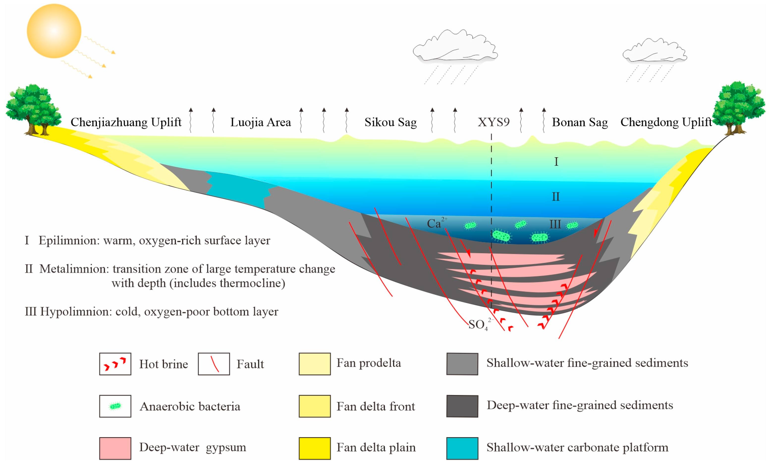
5.2. Model of Gypsum Deposition

Based on the petrological, geochemical, and sedimentological data presented herein, we propose a model for hydrothermal gypsum deposition in half-graben basins.
The source of gypsum is deep sulfur-rich hot brine, and sulfur is mainly found in the form of SO42− in the hot brine. Due to the strong tectonic activity, the deep fault system is the main pathway for the upward movement of the deep hot brine. The rise in deep thermal brine along the basal faults transported ions to the bottom of the lake. As the concentration of SO42− increased and reached the saturation point in combination with Ca2+, it led to the precipitation of gypsum. Gypsum was initially distributed mainly along fractures and overpressure cracks. Then, gradually, thick layers of gypsum formed on top of the dark mudstone as the hot brine continued to be uplifted and spewed out (Figure 9). Because of the combined effect of strong tectonic stress and hot brine intrusion disturbance, gypsum was often coeval and intertwined with dark mudstone (Figure 3).

5.3. Geological Significance of Unconventional Oil and Gas

The vertical configuration of the gypsum–mud interlayer favors the preservation and evolution of organic matter. During the depositional period of the Es4U, the climate was hot and humid and the gross primary productivity of the lake was high due to the abundance of nutrients provided by surface runoff [71]. The rise in deep hot brines led to the rapid deposition of gypsum layers, and biological remains were intact and converted to kerogen through anaerobic bacterial degradation in the strongly reducing environment of deep water. In particular, the dark mudstone interlayers immediately adjacent to the gypsum often reached a high level of evolution and exhibited stronger hydrocarbon production potential than the non-gypsum-bearing segments (Figure 5). Deeply buried mudstone or shale interlayers gradually undergo pyrolytic reactions and induce in situ hydrocarbon production as a result of the organic matter [72], which is sufficiently capped by the deformation of the overlying gypsum lithologies to sequester hydrocarbons in the mud shale. Because of the intermittent and multiperiod characteristics of the thermal brine rise, gypsum–mudstone is frequently stacked and interbedded. Individual gypsum–mudstone depositional cycles form small-scale source–reservoir–seal combinations, and the cumulative sedimentary thickness of this lithoface (as shown in the lithological columns of Figure 5) suggests a substantial reservoir scale in the target interval.
In addition, under the joint action of tectonic stress and vertical compaction, gypsum underwent dehydration to form anhydrite. During this transformation, released crystallization water initiates water–rock reactions in adjacent mudstones, increasing their porosity and permeability while inducing overpressure in the strata. This enhances the mudstone’s dual role as both a hydrocarbon source and reservoir. Concurrently, the thick gypsum layers maintain their sealing properties, acting as seal rock that restricts upward hydrocarbon migration. It should be emphasized that water–rock reactions modifying mudstone porosity do not compromise the gypsum seal: even with minor gypsum transformation, the resistance to migration from the mudstone (source–reservoir) to the overlying gypsum remains high, resulting in low migration efficiency. This establishes a coupled system where mudstones serve as active source reservoirs and gypsum acts as a robust seal.
Based on this study, it was found that (1) the main hydrocarbon source rock of the research section is the muddy interlayer in the gypsum-bearing section and the mud shale underlying the gypsum and that (2) the gypsum–mudstone interbedded sedimentary section is a potential high-quality shale oil and gas reservoir. At present, the gypsum–mudstone interbedded sedimentary section has low oil saturation and low permeability, so it is difficult to exploit oil from this section. The next step is to optimize the indicators and establish a new shale oil evaluation system based on the research results of the depositional mechanism of the gypsum–mudstone interbedded section.

6. Conclusions

(1)
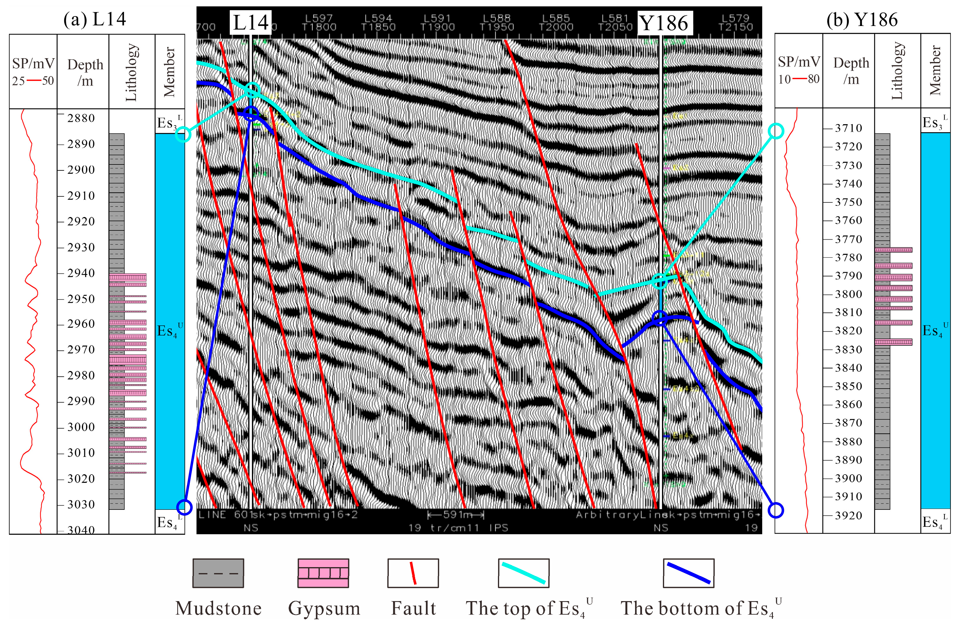
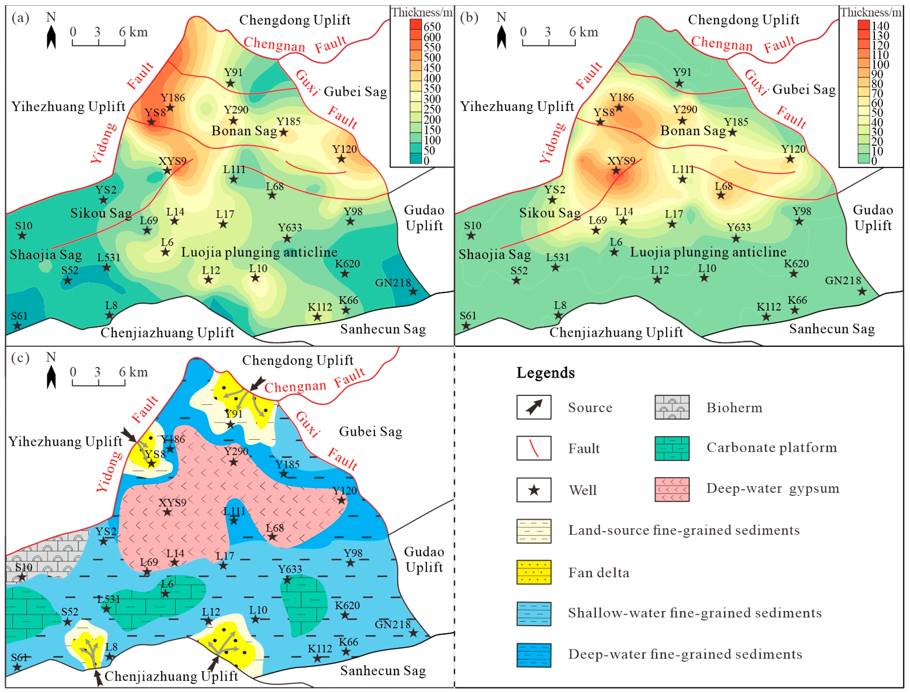
The deposition of gypsum in the Es4U of Zhanhua Sag is dominated by gypsum and gypsum–mudstone, with some gypsum–limestone and gypsum–dolomite. The cumulative thickness of the gypsum-containing section reaches a maximum of over 110 m. The zone with maximum gypsum deposition thickness shows a high coincidence with the spatial distribution of deep faults. Furthermore, the gypsum is more developed and purer in the center of the Zhanhua Sag. It is interbedded with dark mudstone in the vertical direction, showing the characteristic of alternate deposition.
(2)
Microscopic observation identifies the main minerals associated with deep thermohaline activity, such as anhydrite, barite, and authigenic quartz. The production and crystallization structures of the gypsum crystals indicate that the gypsum is not evaporated but is a typical hydrothermal product. The layers that developed the gypsum are extensively fractured, and the gypsum minerals on both sides are not produced simultaneously. Gypsum and mudstone intruded into each other and developed a large number of soft-sediment deformation structures, such as load cast and flame structures. This confirms that gypsum precipitation occurred while underlying mudstone was still unlithified, with hydrothermal fluids interacting with recently deposited mudstone. The mineral composition and developmental characteristics of the gypsum, the contact relationship between gypsum and mudstone, and the depositional sequence reflect the process of intermittent gypsum deposition induced by the pulsed rise in deep thermal brines.
(3)
The strontium isotope ratio (87Sr/86Sr) and other inorganic geochemical data are closely similar to that of the same period of deep-source hydrothermal fluids, indicating that the gypsum was precipitated in situ by the mixing of hot brine intrusion and that the saline materials in this period mainly came from deep hot brine. The isotope fractionation was exacerbated by the strong reduction in microorganisms in the deep-water environment. The mechanism of deep-lake gypsum deposition that establishes thermal brine genesis is summarized as follows: the source of gypsum-forming ions is deep thermal brine, and the deep fault system provides a transportation channel. The hot brine activity in the lake and the tectonic shelf are the main factors that control the depositional location and the spreading pattern of gypsum. The density stratification of the lake basin water body causes the deposition to show obvious zoning.
(4)
Organic geochemical data suggest that the deep-lake gypsum system has superior hydrocarbon potential. The stable layered brine structure provides anoxic and strong reducing conditions in the bottom water body, and the gypsum cover facilitates the preservation and evolution of organic matter. It is summarized that the genetic model of gypsum formation is based on the rise in deep hot brine, in which gypsum and hydrocarbon source rock are closely symbiotic. It could be a self-generation and self-storage model and has great potential to become the focus of shale oil exploration and development.
(5)
This study carries broad scientific and industrial implications. Scientifically, it establishes a hydrothermal genesis model for non-evaporitic gypsum in half-graben basins and provides a new framework for interpreting gypsum–mudstone systems globally. For the exploration of oil and gas, it identifies gypsum–mudstone interlayers as promising shale oil targets, with high TOC (up to 3.15 wt%) and hydrocarbon potential. The proposed self-generation and self-storage model, where gypsum acts as a seal and preserves organic matter, offers novel exploration strategies for basins in China and analogous global settings. This work also integrates isotopic and sedimentological methods for basin-scale resource evaluation, guiding the exploration of unconventional hydrocarbons worldwide.

Author Contributions

Conceptualization, M.C., J.Z. and Z.J.; methodology, M.C. and J.Z.; software, M.C., P.L. and C.J.; validation, J.L., T.M. and C.J.; formal analysis, M.C.; investigation, M.C., J.L. and T.M.; resources, J.Z., J.L., T.M., P.L. and C.J.; data curation, M.C. and J.Z.; writing—original draft preparation, M.C.; writing—review and editing, M.C., J.Z., Z.J. and J.L.; visualization, M.C., P.L. and C.J.; supervision, J.Z.; project administration, J.Z. and Z.J.; funding acquisition, J.Z. and Z.J. All authors have read and agreed to the published version of the manuscript.

Funding

The study was co-funded by the National Key Research and Development Program of China [SQ2023YFF0800034], the China National Key Research Project [2017ZX05009-002], and the National Natural Science Foundation of China [41772090, 41802130].

Data Availability Statement

Data will be made available on request.

Acknowledgments

We thank Sinopec Shengli Oilfield Company for their support. This manuscript benefited from the constructive suggestions of three anonymous reviewers.

Conflicts of Interest

Authors Tao Meng, Peng Liu and Chao Jiang were employed by the Sinopec Shengli Oil Field Company. The remaining authors declare that the research was conducted in the absence of any commercial or financial relationships that could be construed as a potential conflict of interest.

References

  1. Warren, J.K. Evaporites through time: Tectonic, climatic and eustatic controls in marine and nonmarine deposits. Earth-Sci. Rev. 2010, 98, 217–268. [Google Scholar] [CrossRef]
  2. Bouroullec, R.; Weimer, P.; Serrano, O. Petroleum Geology of the Mississippi Canyon, Atwater Valley, western DeSoto Canyon, and western Lloyd Ridge protraction areas, northern deep-water Gulf of Mexico: Traps, reservoirs, and tectono-stratigraphic evolution. AAPG Bull. 2017, 101, 1073–1108. [Google Scholar] [CrossRef]
  3. Hasan, M.N.; Pepper, A.; Mann, P. Basin-scale estimates of thermal stress and expelled petroleum from Mesozoic-Cenozoic potential source rocks, southern Gulf of Mexico. Mar. Pet. Geol. 2023, 148, 105995. [Google Scholar] [CrossRef]
  4. Wu, Z.; Yin, H.; Wang, X.; Zhao, B.; Zheng, J.; Wang, X.; Wang, W. The structural styles and formation mechanism of salt structures in the southern precaspian basin: Insights from seismic data and analog modeling. Mar. Pet. Geol. 2015, 62, 58–76. [Google Scholar] [CrossRef]
  5. Jackson, C.A.L.; Duffy, O.B.; Fernandez, N.; Dooley, T.P.; Hudec, M.R.; Jackson, M.P.A.; Burg, G. The Stratigraphic Record of Minibasin Subsidence, Precaspian Basin, Kazakhstan. Basin Res. 2020, 32, 739–763. [Google Scholar] [CrossRef]
  6. Iadanza, A.; Sampalmieri, G.; Cipollari, P. Deep-seated hydrocarbons in the seep “Brecciated Limestones” of the Maiella area (Adriatic foreland basin): Evaporitic sealing and oil re-mobilization effects linked to the drawdown of the Messinian Salinity Crisis. Mar. Pet. Geol. 2015, 66, 177–191. [Google Scholar] [CrossRef]
  7. Yi, S.; Li, M.; Guo, X.; Yang, F.; Miao, W.; Lin, S.; Gao, Y. Breakthrough direction of Cambrian pre-salt exploration fields in Tarim basin. Acta Petrol. Sin. 2019, 40, 1281–1295. [Google Scholar]
  8. Zhuo, X.; Zheng, X.; Chen, X.; Xu, T.; Cui, J. Forming conditions and indicators for deep-water evaporite deposits in inland lake basins: A case study of the Dongpu Sag and modern salt lakes. Earth Sci. Front. 2021, 28, 43–59. [Google Scholar]
  9. Wittig, C.; Argentino, C.; Panieri, G. Formation of non-evaporitic gypsum in gas hydrate-bearing sediments at Håkon Mosby mud volcano, SW Barents sea. Mar. Pet. Geol. 2024, 165, 106875. [Google Scholar] [CrossRef]
  10. Smith, M.E.; Carroll, A.R.; Singer, B.S. Synoptic reconstruction of a major ancient lake system: Eocene Green River Formation, western United States. Geol. Soc. Am. Bull. 2008, 120, 54–84. [Google Scholar] [CrossRef]
  11. Buck, B.J.; Van Hoesen, J.G. Assessing the applicability of isotopic analysis of pedogenic gypsum as a paleoclimate indicator, Southern New Mexico. J. Arid. Environ. 2005, 60, 99–114. [Google Scholar] [CrossRef]
  12. Gázquez, F.; Morellón, M.; Bauska, T.; Herwartz, D.; Surma, J.; Moreno, A.; Staubwasser, M.; Valero-Garcés, B.; Delgado-Huertas, A.; Hodell, D.A. Triple oxygen and hydrogen isotopes of gypsum hydration water for quantitative paleo-humidity reconstruction. Earth Planet. Sci. Lett. 2018, 481, 177–188. [Google Scholar] [CrossRef]
  13. Bishop, J.L.; Yeşilbaş, M.; Hinman, N.W.; Burton, Z.F.M.; Englert, P.A.J.; Toner, J.D.; McEwen, A.S.; Gulick, V.C.; Gibson, E.K.; Koeberl, C. Martian subsurface cryosalt expansion and collapse as trigger for landslides. Sci. Adv. 2021, 7, eabe4459. [Google Scholar] [CrossRef]
  14. Burton, Z.F.M.; Dafov, L.N. Salt diapir-driven recycling of gas hydrate. Geochem. Geophys. Geosyst. 2023, 24, e2022GC010704. [Google Scholar] [CrossRef]
  15. Vaniman, D.; Chipera, S.; Rampe, E.; Bristow, T.; Blake, D.; Meusburger, J.; Peretyazhko, T.; Rapin, W.; Berger, J.; Ming, D.; et al. Gypsum on Mars: A detailed view at Gale Crater. Minerals 2024, 14, 815. [Google Scholar] [CrossRef]
  16. Dafov, L.N.; Burton, Z.F.M.; Haines, S.S.; Hosford Scheirer, A.; Masurek, N.; Boswell, R.; Frye, M.; Seol, Y.; Graham, S.A. Terrebonne Basin, Gulf of Mexico gas hydrate resource evaluation and 3-D modeling of basin-scale sedimentation, salt tectonics, and hydrate system evolution since the early Miocene. Mar. Pet. Geol. 2025, 176, 107330. [Google Scholar] [CrossRef]
  17. Carmeille, M.; Bourillot, R.; Brunet, M.F.; Pellenard, P.; Fürsich, F.T.; Schnyder, J.; Barrier, E.; Blanpied, C.; Sidorova, I. Architecture and sedimentary evolution of the southwestern Gissar carbonate platform (Uzbekistan) during the Middle—Late Jurassic. Mar. Pet. Geol. 2018, 97, 437–465. [Google Scholar] [CrossRef]
  18. Borrelli, M.; Perri, E.; Critelli, S.; Gindre-Chanu, L. The onset of the Messinian Salinity Crisis in the central Mediterranean recorded by pre-salt carbonate/evaporite deposition. Sedimentology 2021, 68, 1159–1197. [Google Scholar] [CrossRef]
  19. Morad, S.; Farooq, U.; Mansurbeg, H.; Alsuwaidi, M.; Morad, D.; Al-Aasm, I.; Shahrokhi, S.; Hozayen, M.; Koyi, H. Variations in extent, distribution and impact of dolomitization on reservoir quality of Upper Cretaceous foreland-basin carbonates, Abu Dhabi, United Arab Emirates. Mar. Pet. Geol. 2023, 155, 106357. [Google Scholar] [CrossRef]
  20. Driussi, O.; Maillard, A.; Ochoa, D.; Lofi, J.; Chanier, F.; Gaullier, V.; Briais, A.; Sage, F.; Sierro, F.; Garcia, M. Messinian Salinity Crisis deposits widespread over the Balearic Promontory: Insights from new high-resolution seismic data. Mar. Pet. Geol. 2015, 66, 41–54. [Google Scholar] [CrossRef]
  21. Chen, C.; Jiang, Z.; Kong, X.; Wu, S.; Chen, F.; Yang, Y. Sedimentary characteristics of intersalt fine-grained sedimentary rocks and their control on oil-bearing ability of shales in the Qianjiang Formation, Qianjiang Sag. Earth Sci. Front. 2021, 28, 421–435. [Google Scholar]
  22. Briskin, M.; Schreiber, B.C. Authigenic gypsum in marine sediments. Mar. Geol. 1978, 28, 37–49. [Google Scholar] [CrossRef]
  23. Bain, R.J. Diagenetic, nonevaporative origin for gypsum. Geology 1990, 18, 447–450. [Google Scholar] [CrossRef]
  24. Pierre, C. Origin of the authigenic gypsum and pyrite from active methane seeps of the southwest African margin. Chem. Geol. 2017, 449, 158–164. [Google Scholar] [CrossRef]
  25. Burton, Z.F.M.; Bishop, J.L.; Englert, P.A.J.; Szynkiewicz, A.; Koeberl, C.; Dera, P.; McKenzie, W.; Gibson, E.K. A shallow salt pond analog for aqueous alteration on ancient Mars: Spectroscopy, mineralogy, and geochemistry of sediments from Antarctica’s Dry Valleys. Am. Mineral. 2023, 108, 1017–1031. [Google Scholar] [CrossRef]
  26. Foerder, A.B.; Englert, P.A.; Bishop, J.L.; Koeberl, C.; Burton, Z.F.; Patel, S.; Gibson, E.K. Don Juan Basin, Antarctica: A chemically altering environment with martian analog potential. Am. Mineral. 2024, 109, 682–700. [Google Scholar] [CrossRef]
  27. Yoshioka, J.; Kuroda, J.; Matsuzaki, K.M. Cyclostratigraphy of the Miocene Nakayama Formation on Sado Island in central Japan and paleoceanographic implications. Prog. Earth Planet Sci. 2025, 12, 33. [Google Scholar] [CrossRef]
  28. Liu, X.; Li, A.; Dong, J.; Zhuang, G.; Xu, F.; Wan, S. Nonevaporative origin for gypsum in mud sediments from the East China Sea shelf. Mar. Chem. 2018, 205, 90–97. [Google Scholar] [CrossRef]
  29. Zhao, J.; Wang, J.; Phillips, S.C.; Liang, J.; Su, P.; Lin, Q.; Chen, C.; Liu, J. Non-evaporitic gypsum formed in marine sediments due to sulfate-methane transition zone fluctuations and mass transport deposits in the northern South China Sea. Mar. Chem. 2021, 233, 103988. [Google Scholar] [CrossRef]
  30. Meng, T.; Liu, P.; Qiu, L.; Wang, Y.; Liu, Y.; Lin, H.; Cheng, F.; Qu, C. Formation and distribution of the high quality reservoirs in a deep saline lacustrine basin: A case study from the upper part of the 4th member of Paleogene Shahejie Formation in Bonan Sag, Jiyang depression, Bohai Bay Basin, east China. Pet. Explor. Dev. 2017, 44, 948–959. [Google Scholar] [CrossRef]
  31. Dela Pierre, F.; Clari, P.; Natalicchio, M.; Ferrando, S.; Giustetto, R.; Lozar, F.; Lugli, S.; Manzi, V.; Roveri, M.; Violanti, D. Flocculent layers and bacterial mats in the mudstone interbeds of the Primary Lower Gypsum unit (Tertiary Piedmont basin, NW Italy): Archives of palaeoenvironmental changes during the Messinian salinity crisis. Mar. Geol. 2014, 355, 71–87. [Google Scholar] [CrossRef]
  32. Andeskie, A.S.; Benison, K.C.; Eichenlaub, L.A.; Raine, R. Acid-saline-lake Systems of the Triassic Mercia Mudstone Group, County Antrim, Northern Ireland. J. Sediment. Res. 2018, 88, 385–398. [Google Scholar] [CrossRef]
  33. Guo, P.; Li, C. Genesis of evaporites in petroliferous basins and the sedimentary and climatic significances. J. Palaeogeogr. 2022, 24, 210–225. [Google Scholar]
  34. Ma, C. Study on Characteristics and Effectiveness of Lacustrine Shale Reservoir. Ph.D. Dissertation, China University of Petroleum (East China), Qingdao, China, 2017. [Google Scholar]
  35. Yang, Y. Study on Lacustrine Carbonate Reservoirs in Shaojia Area. Ph.D. Dissertation, China University of Geosciences (Beijing), Beijing, China, 2020. [Google Scholar]
  36. Dill, H.G.; Kaufhold, S. The Totumo mud volcano and its near-shore marine sedimentological setting (North Colombia)—From sedimentary volcanism to epithermal mineralization. Sediment. Geol. 2018, 366, 14–31. [Google Scholar] [CrossRef]
  37. Magoon, L.B.; Dow, W.G. The petroleum system. In The Petroleum System—From Source to Trap: AAPG Memoir 60; Magoon, L.B., Dow, W.G., Eds.; American Association of Petroleum Geologists: Tulsa, OK, USA, 1994; pp. 3–24. [Google Scholar]
  38. Zhang, J.; Jiang, Z.; Liu, L.; Yuan, F.; Feng, L.; Li, C. Lithofacies and depositional evolution of fine-grained sedimentary rocks in the lower submember of the member 3 of Shahejie Formation in Zhanhua Sag, Bohai Bay Basin. Acta Petrol. Sin. 2021, 42, 293–306. [Google Scholar]
  39. Tian, R.; Xian, B.; Wu, Q.; Shu, Q.; Liu, J.; Zhang, W.; Wang, Z.; Li, Q.; Rahman, N.U.; Gao, Y.; et al. Turbidite system controlled by fault interaction and linkage on a slope belt of rift basin: Zhanhua depression, Bohai Bay Basin, China. Mar. Pet. Geol. 2023, 155, 106377. [Google Scholar] [CrossRef]
  40. Lin, C.; Zheng, H.; Ren, J.; Qiu, Y. The control of syndepositional faulting on the Eogene sedimentary basin fills of the Dongying and Zhanhua sags, Bohai Bay Basin. Sci. China Ser. D Earth Sci. 2004, 47, 769–782. [Google Scholar] [CrossRef]
  41. Shi, J.; Jin, Z.; Liu, Q.; Huang, Z.; Hao, Y. Terrestrial sedimentary responses to astronomically forced climate changes during the early Paleogene in the Bohai Bay basin, eastern China. Palaeogeogr. Palaeoclimatol. Palaeoecol. 2018, 502, 1–12. [Google Scholar] [CrossRef]
  42. Gupta, D.K.; Deb, U.; Walther, C.; Chatterjee, S. Strontium in the Ecosystem: Transfer in Plants via Root System. In Behaviour of Strontium in Plants and the Environment; Gupta, D.K., Walther, C., Eds.; Springer International Publishing: Berlin/Heidelberg, Germany, 2018; pp. 1–18. [Google Scholar] [CrossRef]
  43. Baddouh, M.; Meyers, S.R.; Carroll, A.R.; Beard, B.L.; Johnson, C.M. Lacustrine 87Sr/86Sr as a tracer to reconstruct Milankovitch forcing of the Eocene hydrologic cycle. Earth Planet. Sci. Lett. 2016, 448, 62–68. [Google Scholar] [CrossRef]
  44. Geng, H.; Sun, M.; Yuan, C.; Xiao, W.; Xian, W.; Zhao, G.; Zhang, L.; Wong, K.; Wu, F. Geochemical, Sr–Nd and zircon U–Pb–Hf isotopic studies of Late Carboniferous magmatism in the West Junggar, Xinjiang: Implications for ridge subduction? Chem. Geol. 2009, 266, 364–389. [Google Scholar] [CrossRef]
  45. Viola, I.; Capozzi, R.; Bernasconi, S.M.; Rickli, J. Carbon, oxygen and strontium isotopic constraints on fluid sources, temperatures and biogeochemical processes during the formation of seep carbonates-Secchia River site, Northern Apennines. Sediment. Geol. 2017, 357, 1–15. [Google Scholar] [CrossRef]
  46. Brookfield, M.E.; Shellnutt, J.G.; Yui, T.-F. Climatic fluctuations during a mass extinction: Rapid carbon and oxygen isotope variations across the Permian-Triassic (PTr) boundary at Guryul Ravine, Kashmir, India. J. Asian Earth Sci. 2022, 227, 105066. [Google Scholar] [CrossRef]
  47. Li, Y.; Allen, M.B.; Li, X.H. Millennial pulses of ore formation and an extra-high Tibetan Plateau. Geology 2022, 50, 665–669. [Google Scholar] [CrossRef]
  48. Birks, H.; Lotter, A.; Juggins, S.; Smol, J. Data handling and numerical techniques. In Tracking Environmental Change Using Lake Sediments; Springer: Dordrecht, The Netherlands, 2012; Volume 5. [Google Scholar] [CrossRef]
  49. Zhao, Y. Vegetation and climate reconstructions on different time scales in China: A review of Chinese palynological research. Veg. Hist. Archaeobot. 2018, 27, 381–392. [Google Scholar] [CrossRef]
  50. Wang, J.; Chen, D.; Yan, D. Variation in carbon and sulphur isotopes and environments during the critical geological transitions. Earth Sci. Front. 2009, 16, 33–47. [Google Scholar]
  51. Wade, B.S.; O’NEill, J.F.; Phujareanchaiwon, C.; Ali, I.; Lyle, M.; Witkowski, J. Evolution of deep-sea sediments across the Paleocene-Eocene and Eocene-Oligocene boundaries. Earth-Sci. Rev. 2020, 211, 103403. [Google Scholar] [CrossRef]
  52. Pogge von Strandmann, P.A.; Jones, M.T.; West, A.J.; Murphy, M.J.; Stokke, E.W.; Tarbuck, G.; Wilson, D.J.; Pearce, C.R.; Schmidt, D.N. Lithium isotope evidence for enhanced weathering and erosion during the Paleocene-Eocene Thermal Maximum. Sci. Adv. 2021, 7, eabh4224. [Google Scholar] [CrossRef]
  53. Burton, Z.F.M.; McHargue, T.; Kremer, C.H.; Bloch, R.B.; Gooley, J.T.; Jaikla, C.; Harrington, J.; Graham, S.A. Peak Cenozoic warmth enabled deep-sea sand deposition. Sci. Rep. 2023, 13, 1276. [Google Scholar] [CrossRef]
  54. Burton, Z.F.M.; McHargue, T.R.; Graham, S.A. Global Eocene-Oligocene unconformity in clastic sedimentary basins. Earth-Sci. Rev. 2024, 258, 104912. [Google Scholar] [CrossRef]
  55. Bougeois, L.; Dupont-Nivet, G.; de Rafélis, M.; Tindall, J.C.; Proust, J.-N.; Reichart, G.-J.; de Nooijer, L.J.; Guo, Z.; Ormukov, C. Asian monsoons and aridification response to Paleogene sea retreat and Neogene westerly shielding indicated by seasonality in Paratethys oysters. Earth Planet. Sci. Lett. 2018, 485, 99–110. [Google Scholar] [CrossRef]
  56. Wang, J.; Peng, J.; Cao, Y.; Liu, K.; Song, M.; Liu, H. Mid-late Eocene paleoclimate characteristics and significance in the Dongying depression: An example from well hk-1. Acta Sedimentol. Sin. 2022, 40, 1059–1072. [Google Scholar]
  57. Liu, P.; Song, G.; Liu, Y.; Meng, T. Mechanism of depositional system in upper fourth member of Shahejie Formation in Bonan Sag. J. Cent. South Univ. 2014, 45, 3234–3243. [Google Scholar]
  58. Gou, H.; Wei, H.; Duan, R.; Chen, T.; Fan, Q.; Du, Y.; Cao, X. Spatial distribution of modern pollen and fungal spores and their ecological indication in Qinghai Lake on northeastern Tibetan Plateau, China. Ecol. Indic. 2022, 144, 109474. [Google Scholar] [CrossRef]
  59. Reiss, A.G.; Gavrieli, I.; Rosenberg, Y.O.; Reznik, I.J.; Luttge, A.; Emmanuel, S.; Ganor, J. Gypsum Precipitation under Saline Conditions: Thermodynamics, Kinetics, Morphology, and Size Distribution. Minerals 2021, 11, 141. [Google Scholar] [CrossRef]
  60. Kraemer, B.M.; Anneville, O.; Chandra, S.; Dix, M.; Kuusisto, E.; Livingstone, D.M.; Rimmer, A.; Schladow, S.G.; Silow, E.; Sitoki, L.M.; et al. Morphometry and average temperature affect lake stratification responses to climate change. Geophys. Res. Lett. 2015, 42, 4981–4988. [Google Scholar] [CrossRef]
  61. Ladwig, R.; Rock, L.; Dugan, H. Impact of salinization on lake stratification and spring mixing. Limnol. Oceanogr. Lett. 2021, 8, 93–102. [Google Scholar] [CrossRef]
  62. Woolway, R.I.; Sharma, S.; Weyhenmeyer, G.A.; Debolskiy, A.; Golub, M.; Mercado-Bettin, D.; Perroud, M.; Stepanenko, V.; Tan, Z.; Grant, L.; et al. Phenological shifts in lake stratification under climate change. Nat. Commun. 2021, 12, 2318. [Google Scholar] [CrossRef]
  63. Peters, K.E.; Walters, C.C.; Moldowan, J.M. The Biomarker Guide: Volume 1: Biomarkers and Isotopes in the Environment and Human History; Cambridge University Press: Cambridge, UK, 2004. [Google Scholar]
  64. Burton, Z.F.M.; Moldowan, J.M.; Magoon, L.B.; Sykes, R.; Graham, S.A. Interpretation of source rock depositional environment and age from seep oil, east coast of New Zealand. Int. J. Earth Sci. 2019, 108, 1079–1091. [Google Scholar] [CrossRef]
  65. Song, Y.; Gilleaudeau, G.J.; Algeo, T.J.; Over, D.J.; Lyons, T.W.; Anbar, A.D.; Xie, S. Biomarker evidence of algal-microbial community changes linked to redox and salinity variation, Upper Devonian Chattanooga Shale (Tennessee, USA). Geol. Soc. Am. Bull. 2020, 133, 409–424. [Google Scholar] [CrossRef]
  66. Amadi, F.O.; Major, R.P.; Baria, L.R. Origins of gypsum in deep carbonate reservoirs: Implications for hydrocarbon exploration and production. AAPG Bull. 2012, 96, 375–390. [Google Scholar] [CrossRef]
  67. Liu, P. Characteristics and petroleum geological significance of gypsum-salt beds in the upper part of fourth member of Shahejie Formation in Bonan Sag. J. Shengli Coll. China Univ. Petrol. 2019, 33, 10–13. [Google Scholar]
  68. Faure, G. Origin of Igneous Rocks: The Isotopic Evidence; Springer: Berlin/Heidelberg, Germany, 2001. [Google Scholar] [CrossRef]
  69. Weber, N.; Antler, G.; Lazar, B.; Stein, M.; Yechieli, Y.; Gavrieli, I. Hydrological and thermodynamic controls on late Holocene gypsum formation by mixing saline groundwater and Dead Sea brine. Geochim. Cosmochim. Acta 2022, 316, 363–383. [Google Scholar] [CrossRef]
  70. Moneron, J. Major heterogeneity in evaporitic depositional systems: The genesis of kilometre-scale gypsum networks in the Zechstein Basin. Global Planet. Change 2025, 246, 104710. [Google Scholar] [CrossRef]
  71. Zhang, S.; Zhang, L.; Li, Z.; Hao, Y. Formation conditions of Paleogene shale oil and gas in Jiyang depression. Pet. Geol. Recovery Effic. 2012, 19, 5. [Google Scholar]
  72. Zhao, Z.; Zhou, Y.; Ma, X.; Ji, G. The impact of saline deposit upon the hydrocarbon accumulation in petroliferous basin. Oil Gas Geol. 2007, 28, 299–308. [Google Scholar]
Figure 1. (a) Geological setting of the Bohai Bay Basin during the Eocene period. The Zhanhua Sag of the Jiyang Depression is shown in the red rectangle. (b) Tectonic units and stratigraphic characteristics of the Zhanhua Sag. The locations of the cored wells in the study are annotated by a pentagram. (c) Stratigraphic characteristics of the Zhanhua Sag (A–A’ see the location in (b)).
Jmse 13 01300 g001
Figure 2. Comprehensive stratigraphic column of the Zhanhua Sag. Es4: the fourth member of the Paleogene Shahejie Formation. The strata for this study are annotated by blue in the stratigraphy column. The age data are derived from Zhang et al. [38].
Jmse 13 01300 g002
Figure 3. Petrological characteristics of gypsum in the Es4U, Zhanhua Sag, Bohai Bay Basin: (a) 2970.20 m, well L14, gray muddy reticulated segmented gypsum; (b) 2972.70 m, well L14, irregular gypsum patches; (c) 2992.50 m, well L14, convolute laminations; (d) 3720.80 m, well TS12, dense networks of fibrous gypsum veins; (e) 4201.25 m, well YY1-2, gypsum veins intertwined in dark mudstone; (f) 2849.33 m, well YS2, two white gypsum nodules; (g) 3848.90 m, well YS2, gypsum rock interspersed with mudstone; (h) 3471.52 m, well XYS9, gypsum rock interspersed with mudstone; (i) 3474.22 m, well XYS9, gypsum is present as clusters of irregular patches in dark mudstone.
Jmse 13 01300 g003
Figure 4. Microscopic characteristics of gypsum in the Es4U, Zhanhua Sag, Bohai Bay Basin: (a) 3000.90 m, well L14, plane-polarized light, gypseous mudstone, large gypsum crystals, intergranular pores and seams, authigenic origin; (b) 3471.90 m, well XYS9, plane-polarized light; (c) 3000.90 m, well L14, cross-polarized light, a gypsum vein embedded in the matrix; (d) 4176.64 m, well Y186, cross-polarized light, coarse fibrous gypsum; (e) 4176.64 m, well Y186, cross-polarized light, gypsum (g) crystals completely engulfed by anhydrite (an); (f) 4176.64 m, well Y186, cross-polarized light.
Jmse 13 01300 g004
Figure 5. Histogram of the hydrocarbon generation index of well XYS9 in the Es4U, Zhanhua Sag, Bohai Bay Basin. Abbreviations: TOC = total organic carbon; “A” = chloroform bitumen A; S1 = residual hydrocarbon content; S2 = remaining hydrocarbon potential; RO = vitrinite reflectance. Average: TOC, 2.35 wt%; S1 + S2, 5.5 mg HC/g; RO, 0.75%.
Jmse 13 01300 g005
Figure 6. Statistical bar chart of the dominant species of pollen and fungal spores in the Es4U, Zhanhua Sag, Bohai Bay Basin. The dominant genera are Quercoidites and Ulmipollenites.
Jmse 13 01300 g006
Figure 7. North–south seismic profile through wells L14 and Y186. Es4U: the upper fourth member of the Paleogene Shahejie Formation.
Jmse 13 01300 g007
Figure 8. Sedimentary maps of the Es4U, Zhanhua Sag, Bohai Bay Basin. (a) Isopach map of true stratigraphic thickness. (b) Isopach map of gypsum-containing stratigraphic thickness. (c) Sedimentary facies diagram. The Bonan sub-sag exhibits the thickest gypsum deposits, with highly developed deep and extensive faults.
Jmse 13 01300 g008
Figure 9. Genetic model of gypsum produced by hydrothermal brine in the Es4U, Zhanhua Sag, Bohai Bay Basin. Ion source: deep thermal brine; transportation channel: deep fault system; controlling factors of gypsum depositional pattern: tectonic shelf and density stratification.
Jmse 13 01300 g009
Table 1. Sulfur isotope of gypsum in the Es4U, Zhanhua Sag, Bohai Bay Basin.
WellDepth (m)Lithologyδ34S (‰)σ (‰)
L142952.11Gypsum37.600.012
L143000.90Gypsum37.000.012
L6022650.51Gypsum35.100.012
L6022650.81Gypsum35.000.012
Y1864176.64Gypsum34.700.012
Y1864177.23Gypsum37.500.012
YS63503.60Gypsum30.930.012
YS63513.90Gypsum31.000.012
YS63523.70Gypsum30.220.012
XYS93470.22Gypsum35.100.012
XYS93471.00Gypsum35.200.012
XYS93473.00Gypsum35.900.012
XYS93473.14Gypsum34.800.012
Table 2. Strontium isotope of gypsum in the Es4U, Zhanhua Sag, Bohai Bay Basin.
WellDepth (m)Lithology87Sr/86SrAbsolute Error
(2σ)
L143000.90Gypsum0.7093590.000012
L142952.11Gypsum0.7095540.000014
L6022650.51Gypsum0.7097500.000018
L6022650.81Gypsum0.7097380.000016
Y1864176.64Gypsum0.7091520.000021
Y1864177.23Gypsum0.7091770.000021
L23125.50Gypsum0.7097070.000016
Table 3. Oxygen isotope of the Es4U, Zhanhua Sag, Bohai Bay Basin.
WellDepth (m)Lithologyδ18OPDB (‰)
L673380.5Gypseous mudstone−7
L673380.95Gypseous mudstone−7.5
L673382.75Gypsum rock−6.7
L673448.34Gypsum rock−11.8
L673448.87Gypsum rock−13.3
L673450.77Gypseous mudstone−11.9
Disclaimer/Publisher’s Note: The statements, opinions and data contained in all publications are solely those of the individual author(s) and contributor(s) and not of MDPI and/or the editor(s). MDPI and/or the editor(s) disclaim responsibility for any injury to people or property resulting from any ideas, methods, instructions or products referred to in the content.

