Article

Sequence Stratigraphic and Geochemical Records of Paleo-Sea Level Changes in Upper Carboniferous Mixed Clastic–Carbonate Successions in the Eastern Qaidam Basin

1
School of Energy Resources, China University of Geosciences (Beijing), 29th Xueyuan Rd., Haidian, Beijing 100083, China
2
Institute of Geomechanics, Chinese Academy of Geological Sciences, 11th Renmin University South Rd., Haidian, Beijing 100081, China
3
Chinese Academy of Geological Sciences, 26th Baiwanzhuang St., Haidian, Beijing 100044, China
4
Exploration and Development Research Institute, Zhongyuan Oilfield Company, SINOPEC, Puyang 457001, China
*
Author to whom correspondence should be addressed.
J. Mar. Sci. Eng. 2025, 13(7), 1299; https://doi.org/10.3390/jmse13071299
Submission received: 6 April 2025 / Revised: 11 June 2025 / Accepted: 19 June 2025 / Published: 2 July 2025

Abstract

The Upper Carboniferous strata in the eastern Qaidam Basin, comprising several hundred meters of thick, mixed clastic–carbonate successions that have been little reported or explained, provide an excellent geological record of paleoenvironmental and paleo-sea level changes during the Late Carboniferous icehouse period. This tropical carbonate–clastic system offers critical constraints for correlating equatorial sea level responses with high-latitude glacial cycles during the Late Paleozoic Ice Age. Based on detailed outcrop observations and interpretations, five facies assemblages, including fluvial channel, tide-dominated estuary, wave-dominated shoreface, tide-influenced delta, and carbonate-dominated marine, have been identified and organized into cyclical stacking patterns. Correspondingly, four third-order sequences were recognized, each composed of lowstand, transgressive, and highstand system tracts (LST, TST, and HST). LST is generally dominated by fluvial channels as a result of river juvenation when the sea level falls. The TST is characterized by tide-dominated estuaries, followed by retrogradational, carbonated-dominated marine deposits formed during a period of sea level rise. The HST is dominated by aggradational marine deposits, wave-dominated shoreface environments, or tide-influenced deltas, caused by subsequent sea level falls and increased debris supply. The sequence stratigraphic evolution and geochemical records, based on carbon and oxygen isotopes and trace elements, suggest that during the Late Carboniferous period, the eastern Qaidam Basin experienced at least four significant sea level fluctuation events, and an overall long-term sea level rise. These were primarily driven by the Gondwana glacio-eustasy and regionally ascribed to the Paleo-Tethys Ocean expansion induced by the late Hercynian movement. Assessing the history of glacio-eustasy-driven sea level changes in the eastern Qaidam Basin is useful for predicting the distribution and evolution of mixed cyclic succession in and around the Tibetan Plateau.

1. Introduction

The Upper Carboniferous coal-bearing strata in the eastern Qaidam Basin represent a very distinctive sedimentary unit, characterized by mixed clastic and carbonate rocks arranged in meter- to tens-of-meters-scale cycles. This unit is receiving increasing attention from petroleum geoscientists and is considered to be the most promising hydrocarbon-bearing system in the Qaidam Basin. Mixed siliciclastic–carbonate successions are more common during icehouse periods than in transitional and greenhouse periods [1,2,3,4] and are especially well-developed in the Permian–Carboniferous and Quaternary. This is a result of glacio-eustasy [1,3,5,6] and frequent alterations between wet and dry climatic conditions [6,7,8]. These cyclic successions provide critical insights into Earth’s paleoclimate dynamics and can serve as analogs for understanding future sea level responses to modern climate change. During glacial periods, high-frequency, large-magnitude sea level declines occur, and terrigenous debris is supplied in abundance to shelves and basins in humid climates. Subsequently, during sea level rises associated with glacier melting or interglacial periods and the flooding of coastal plains, carbonates are extensively deposited in warm climates [2]. Thus, mixed carbonate–clastic successions are typical during icehouse periods when sea level rises and falls are of high amplitude and high frequency.
The formation period of the Upper Carboniferous mixed succession in the eastern Qaidam Basin corresponds to the Gondwana Glacier event and the late stage of the Hercynian movement, during which the Paleo-Tethys Ocean subducted northward. The Qaidam Basin, located on the northern Tibetan Plateau, is an ideal place in which to study changes in Gondwana ice volume and the accompanying sea level changes and to understand the impact of the Paleo-Tethys Ocean expansion.
This study aims to contribute to answering the question of how glacier-driven sea level changes and tectonic movements have influenced the formation and evolution of the mixed clastic–carbonate succession in this region. The main purpose of the present study is to reconstruct the detailed regional sea level fluctuations and to explain the mechanisms behind the formation of mixed clastic–carbonate successions during the Late Carboniferous period in the Qaidam Basin. However, estimating the magnitude of relative sea level fluctuations from the deposition record is challenging. Therefore, we apply both sedimentological and geochemical data from the well-preserved, continuous stratigraphic record of the Shihuigou section (Figure 1), integrating carbon and oxygen isotope and trace element analyses in paleoenvironmental reconstruction. Carbon and oxygen isotopes are capable of recording global signals and excellent proxies for changes in paleo-oceanographic settings, including paleoenvironment and paleo sea level changes [9,10]. This approach has recently been widely used to reconstruct Carboniferous–Early Permian carbon cycles, paleo-ocean temperatures, and glaciation. In addition, redox-sensitive trace elements (RSTEs), such as Mo (molybdenum), U (uranium), and V (vanadium), are commonly considered indicators of redox conditions in paleo-marine systems [10,11,12,13]. In this context, reconstruction of paleo-sea-level can be achieved using sedimentology, sequence stratigraphy, and geochemical records. In turn, estimating the magnitude of relative sea level change is useful for better understanding the high-frequency cyclical successions [14] and the driving mechanisms behind the formation of mixed clastic–carbonate successions, which is a key issue in the geological study in the Qaidam Basin. Moreover, reconstruction of the relative sea level change history in the eastern Qaidam Basin is believed to have significant implications for assessing sea level change history to predict distribution and evolution of such cyclic successions in and around the Tibetan Plateau.

2. Geological Setting and Stratigraphy

2.1. Tectonic Background

The Qaidam Basin, located in the northeastern segment of the Tibetan Plateau, constitutes a crucial structural unit within the broader Cenozoic orogenic framework resulting from the India–Asia continental collision. Encompassing an area of approximately 240,000 km2 and situated at an average elevation of 2800 m, the basin exhibits a structurally complex and tectonically active architecture. It is bounded by three prominent orogenic systems: the Qilian Shan thrust system to the northeast, the Altyn Tagh fault zone—characterized by significant left-lateral strike–slip movement—to the northwest, and the Eastern Kunlun thrust belt to the south [17,18]. These bounding elements have significantly shaped the basin’s configuration and long-term sedimentary evolution (Figure 1).

2.2. Structural Evolution
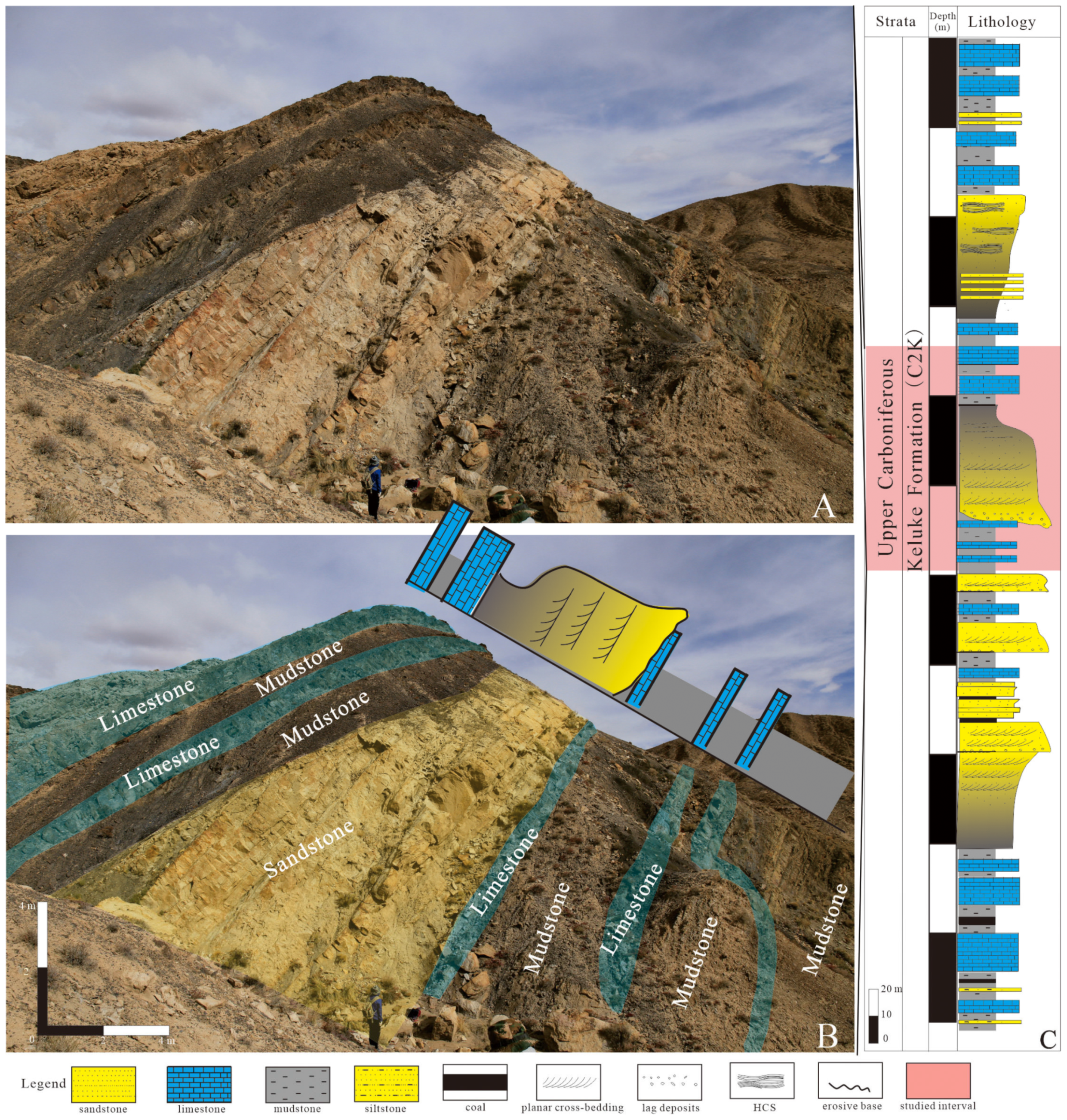
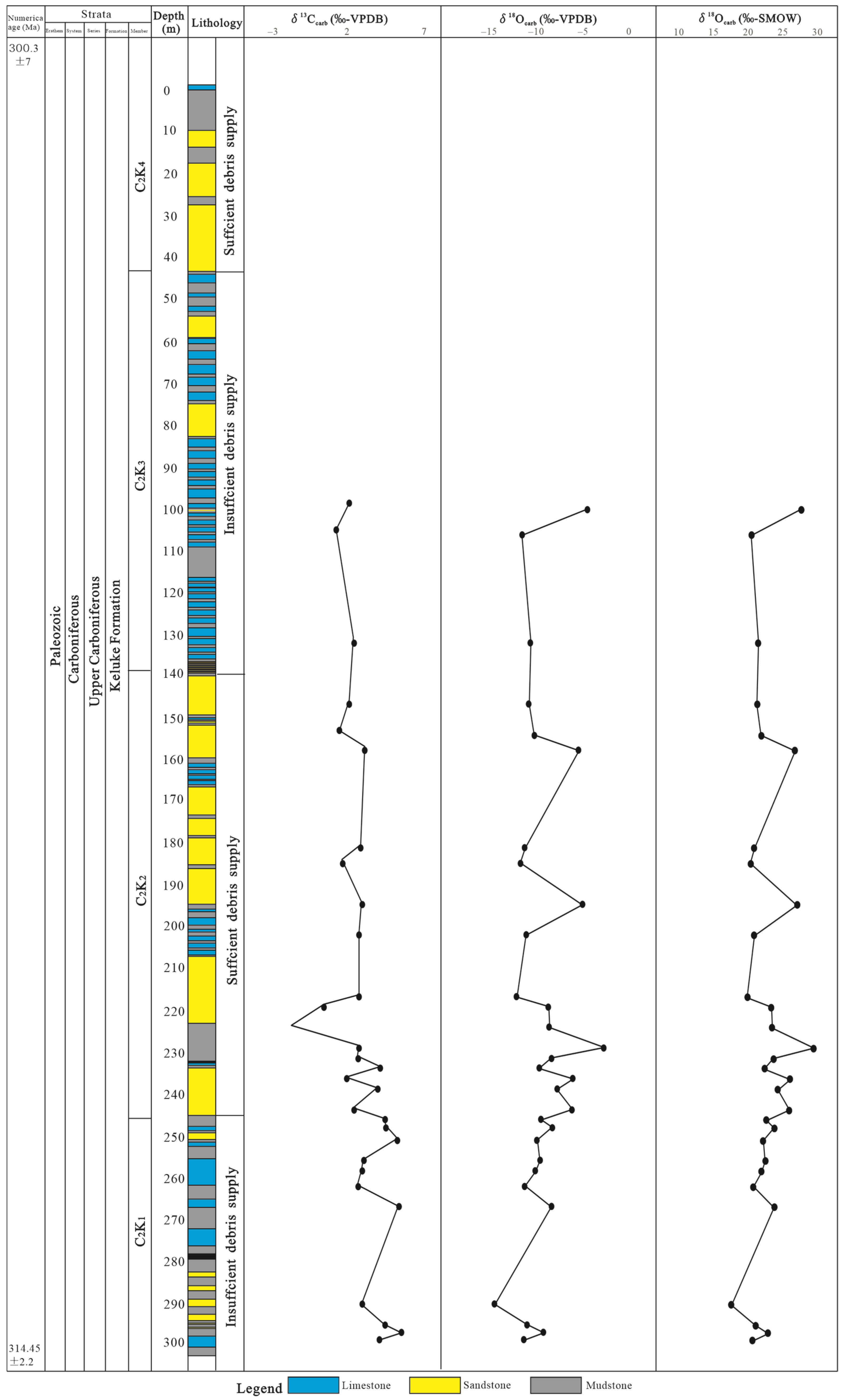
In its eastern part, the Qaidam Basin exhibits a distinct pattern of structural compartmentalization, composed of alternating sub-basins (such as the Delingha and Hobson depressions) and intervening structural highs (e.g., Oronbruck and Emnick). These elements are demarcated by NW–SE-trending fault systems, including the Zongwulong and Kunlun faults, which have acted as persistent tectonic boundaries since the Paleozoic era. During the Late Paleozoic, the Qaidam region was positioned between the active Paleo-Tethyan margin to the south and the relatively stable North China Craton to the east. Recent geodynamic reconstructions suggest that during this period, the basin functioned as a retroarc foreland system, displaying a marked north–south facies transition from fluvial–deltaic to shallow marine depositional environments.

2.3. Stratigraphy

The Carboniferous stratigraphic succession in the eastern Qaidam Basin is well differentiated, reflecting dynamic shifts in depositional environments (Figure 2). The Lower Carboniferous is composed of three major formations: the Chuanshangou Formation (C1ch) and the Chengqianggou Formation (C1c), consisting of fluvial to deltaic siliciclastics, and the Huaitoutala Formation (C1h), which represents shallow marine carbonate platform deposits. The Upper Carboniferous is dominated by the Keluke Formation (C2k), which is the primary focus of this study, and is characterized by a transitional setting of mixed siliciclastic–carbonate sediments. This formation is subdivided into four members: C2K1, comprising coal-bearing siliciclastics; C2K2, dominated by heterolithic clastic sequences; C2K3, consisting of sandstone-dominated, mixed clastic–carbonate packages; and C2K4, characterized by carbonate-rich intervals. Overlying these is the Lower Permian Zhabusagaxiu Formation (P1zh), consisting of regionally extensive carbonate platform deposits. Together, these strata reflect a complete transgressive–regressive cycle, with the Keluke Formation capturing the most complex and cyclic mixed sedimentary regime.

2.4. Paleoclimatic and Tectonic Controls

Deposition during the Late Carboniferous was strongly modulated by a combination of global and regional factors. The basin was affected by multiple Gondwanan glacial episodes (C1–C4), which occurred between 320 and 300 Ma, leading to high-amplitude (100–200 m) glacio-eustaticic sea level fluctuations [19,20]. Concurrently, the northward subduction of the Paleo-Tethys Ocean beneath the Asian continental margin induced flexural subsidence across the Qaidam region, providing sufficient accommodation for thick sediment accumulations [21]. Paleomagnetic data place the basin at a low northern paleolatitude (~10° N) during this interval, implying warm and humid climatic conditions favorable for both carbonate production and organic matter preservation [22]. These climatic and tectonic forces together generated cyclic mixed siliciclastic–carbonate successions, with high-frequency depositional cycles (104–105 years) driven primarily by glacio-eustasy and longer-term stratigraphic trends (106 years) governed by tectonic subsidence and regional paleoceanographic shifts [5,23].

3. Database and Methodology

3.1. Sample and Data Collection

The primary dataset for this study was derived from detailed field investigations of the Shihuigou section, a well-exposed Upper Carboniferous succession in the study area. The fieldwork included (1) high-resolution stratigraphic logging (1:50 scale) to document lithology, sedimentary structures, and facies variations and (2) systematic sampling of 34 representative rock samples for geochemical analysis, covering different lithologies including limestone, mudstone, and sandstone.

3.2. Depositional Environment Analysis

We distinguish and describe the grain size, lithology, sedimentary texture, sedimentary structure, facies stacking pattern, and intensity and diversity of trace fossils, with particular emphasis on the typical fluvial, tidal, and wave signatures [24,25,26]. These observations are interpreted to reconstruct depositional environments, aiming to understand their spatial relationship to the shoreline and thus assist in identifying trends in sea-level change [27].

3.3. Sequence Stratigraphic Framework

The sequence stratigraphic framework construction was constructed based on the facies analysis and the recognition of exposure surfaces, flooding surfaces, and the stacking patterns of parasequences [27,28]. This approach enabled the subdivision of the succession into systems tracts and the correlation of depositional cycles across the study area.

3.4. Carbon and Oxygen Isotope Analysis

In addition to outcrop measurement and description, 34 rock samples were processed into powder for carbon and oxygen isotope analysis (δ13C−δ13C− carb and δ18O−δ18O− carb). The carbonate extraction procedure involved acid digestion: finely ground samples were treated with 100% phosphoric acid in a vacuum. Reaction temperatures and durations were adjusted based on lithology; limestone samples were digested at 25 °C for 24 h, dolomite-rich samples at 50 °C for the same duration, dolostone at 75 °C for 16 h, and mudstone at 75 °C for 24 h, adhering to the previous methods [26]. The released CO2 was measured using a Finnigan MAT-253 mass spectrometer at the Analytical Laboratory of the Beijing Research Institute of Uranium Geology. Isotopic values are expressed in δδ-notation relative to the Vienna Pee Dee Belemnite (VPDB) standard, achieving an analytical accuracy of better than ±0.1‰ for δ13C−δ13C− and ±0.2‰ for δ18O−δ18O−.

3.5. Integrated Sea Level Reconstruction

The reconstruction of sea level change history involved the assessment and comparison of the sea level change trend through sequence stratigraphy and recorded paleoenvironmental indicators from geochemical data [1,29,30].

4. Results

4.1. Sedimentary and Sequence Stratigraphic Characteristics

According to the outcrop and core observations, we describe the clastic and carbonate facies assemblages separately, and five main types of facies associations are identified as follows based on the characteristics of lithology, grain size, sedimentary structure, bioturbation intensity and variety, and the vertical sedimentary sequence (Figure 3).

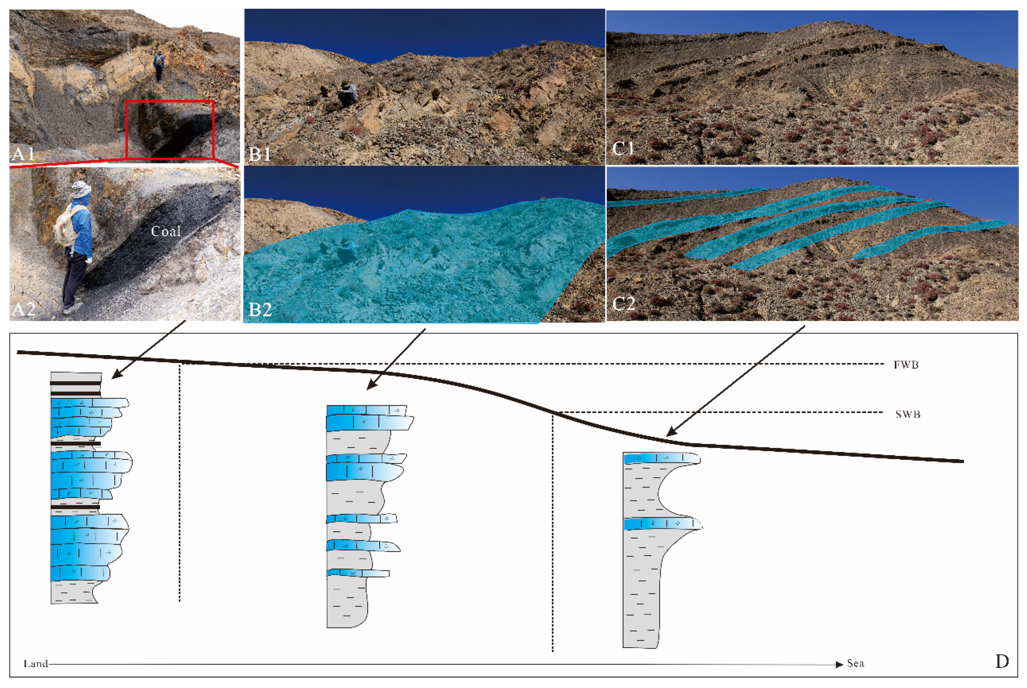
4.1.1. Facies Association and Interpretation

Facies Association 1: Fluvial Channels
Description: Facies Association 1 (FA1) is a relatively coarse-grained, finning-upward package only a few meters thick, formed above the basal erosion surface. It is volumetrically dominated by lithic conglomerates and coarse-grained and medium-grained sandstones. The primary sedimentary structures are unidirectional trough and planar cross-bedding, and crudely massive bedding. Coal layers, coal chips, root horizons, and plant fragments are occasionally present, and they typically lie above the internal erosion surfaces. Soft-sediment deformation can be observed locally but marine trace fossils are absent in FA1.
Interpretation: The association of coarse-grained sandstones, basal erosion surfaces, and unidirectional cross-stratification; the presence of coal layers, coal chips, root horizons, and plant fragments; and the lack of marine trace fossils strongly suggest deposition in a fluvial channel environment [31,32]. The presence of soft-sediment deformation is probably linked to episodic river events with high depositional rates [33].
Facies Association 2: Tide-Dominated Estuary
Description: Facies Association 2 (FA2) is positionally above fluvial channel deposits and can be further subdivided into two distinct parts, FA2.1 and FA2.2 (Figure 4). FA2.1 comprises coarse-grained, poorly-sorted sandstones with a sharp erosive base (Figure 4 B). The unit displays a finning-upward trend and exhibits scattered inclined bedding surfaces and low-angle stratification. Bedding contacts are irregular, and internal mudstone is sparse. The upper FA2.2 is dominated by thick-bedded, medium-grained sandstones that are exceptionally clean and well sorted. This interval is characterized by stacked sets of large-scale cross-stratification, including both planar and trough forms (Figure 4A,C,D). Cross-sets are internally well-preserved, often showing bidirectional dips at high angles (Figure 4A,D). Multiple cross-sets are organized into larger-scale structures composed of bottomsets and foresets, with individual units reaching several meters in thickness (typical of compound dunes) (Figure 4A). These units commonly show an upward increase in grain size, set thickness, and foreset dip angle, while mud content decreases upward. Beds are laterally continuous, and bounding surfaces are sharp and planar. The sandstones are exceptionally clean and mud-free, and the beds exhibit a slight fining- and thinning-upward trend. Near the top of FA2.2, a rhythmic alternation of sandstone and mudstone layers is present (Figure 4E). The sandstone beds are thin to medium in thickness and sharply bounded, whereas the mudstone intervals are fine-grained, laterally persistent, and may display horizontal lamination, desiccation cracks, or bioturbation structures.
Interpretation: FA2 is interpreted as a tide-dominated estuarine succession, with the two sub-units reflecting a progressive increase in tidal influence [24,28]. FA2.1 represents the inner-estuary reach, where fluvial channel fills were reworked by tidal currents. The sharp erosional base, poor sorting, and fining-upward trend are typical of tide-modified fluvial channels in the landward part of the estuary [24,34]. FA2.2 captures deposition under strong, cyclic tidal currents, particularly in the outer estuary or central basin. The abundance of compound dunes, defined by their internal stacking of multiple cross-sets, upward-coarsening motifs, increasing set thickness, and bidirectional foreset orientations, indicates sustained bedform migration under energetic ebb and flood flows. Such structures are typically formed under conditions of high tidal current velocity and regular flow reversals and are distinct from fluvial dunes in their internal complexity and rhythmically alternating paleoflow directions [24,35,36]. The near-absence of mud within these sandstones is attributed to intense tidal winnowing that removes fine particles in such high-energy settings [36,37]. The upper rhythmic sandstone–mudstone alternations are interpreted as tidal couplets, documenting regular tidal cyclicity; desiccation cracks in some fine-grained layers indicate periodic subaerial exposure on intertidal flats [31].
Facies Association 3: Tide-Influenced Delta
Description: Facies Association 3 (FA3) is a coal-bearing clastic interval that reaches tens of meters in thickness and exhibits an overall coarsening-upward trend followed by a finning-upward motif. Vertically, FA3 is divided into three distinct intervals (Figure 5). The basal part comprises intensively bioturbated muddy interval a few meters thick, which gradually transitions into the middle sandstone-dominated interval. The middle interval is several to tens of meters thick, well-organized, stacked cross-strata (compound dunes), which are relatively well sorted, showing carbonaceous drapes or mud laminae in places. The top heterolithic intervals contain varying lithology, ranging from mudstones to fine-grained sandstones with coarse-grained sandstones and conglomeratic sandstones. The uppermost interval is commonly erosively-based, poorly-sorted, fine-to coarse-grained sandstone packages, which are weakly to non-bioturbated without marine traces, showing a finning-upward trend above the erosive surfaces. Organic-rich mud clasts, coal fragments, and pebble conglomerate lags are lined above the erosion surfaces. The primary sedimentary structures in the sandstones are trough and planar cross-strata as well as flaser, lenticular and wavy bedding.
Interpretation: The vertical facies arrangement of FA3 reflects deposition within a tide-influenced deltaic system. The lower bioturbated mudstone interval is interpreted as a prodelta deposit, formed in a low-energy, marine-influenced setting [31,38]. The bottom bioturbated mudstone interval of these three intervals is likely made up of prodelta deposits formed in a low-energy, marine-influenced setting. The middle interval characterized by well-organized, cross-stratified sandstones is made up of stacked compound dunes formed as tidal bars in a tidally energetic environment within the delta front [31,36]. The presence of pebble conglomerates and coal fragments and the absence of brackish and marine trace fossils suggest a strong terrestrial influence [37]. The erosionally based finning-upward sandstone units dominated by unidirectional cross-strata that capped at the coarsening-upward succession are therefore interpreted as delta-plain fluvial channels. This upward transition from marine-influenced to terrestrial-dominated facies reflects delta progradation and increasing fluvial influence within a tide-influenced deltaic depositional system [34,38].
Facies Association 4: Wave-Dominated Shoreface
Description: Facies Association 4 (FA4) is made up of coarsening-upward packages that record a transition from highly bioturbated mudstones towards thin interbeds of very fine- to fine-grained sandstones dominated by wave ripples and a final evolution into clean, fine-grained sandstones dominated by amalgamated hummocky (HCS) and swaley (SCS) stratification (Figure 6). The bottom mudstones are usually highly bioturbated and show variable and intensive trace fossils. These mudstones are overlain by thinly interbedded very fine- to fine-grained sandstones and mudstones characterized by wave ripples and moderate bioturbation. In the above section, the succession grades into clean, fine-grained sandstones dominated by amalgamated hummocky cross-stratification (HCS) and swaley cross-stratification (SCS) (Figure 6B,D), occasionally showing low-angle parallel lamination and symmetrical ripples.
Interpretation: The coarsening-upward trend from bioturbated mudstone to amalgamated HCS/SCS sandstones reflects progradation of a wave-dominated shoreface. The HCS and SCS are widely recognized as products of storm-wave-generated structures and are typical of a storm-wave-dominated environment between the fairweather wave base and the storm wave base [39,40,41,42]. The basal bioturbated mudstones likely represent offshore to transition zone deposition under relatively low-energy, fair-weather conditions [42], while the overlying laminated and storm-structured sandstones correspond to lower and upper shoreface deposits formed under storm-dominated conditions with increasing wave influence.
Facies Association 5: Carbonate-Dominated Shallow Marine
Description: Facies Association 5 (FA5) consists of thin (<3 m) carbonaceous intervals of interbedded mudstone of variable thicknesses and stacking patterns (Figure 7). The carbonate lithofacies include calcareous shale, lime mudstone, skeletal wackstone, packstones, and grainstones. These facies contain abundant fossil assemblages, including brachiopods, bivalves, crinoid, and plant remains. In vertical profile, the succession typically initiates with relatively clean, fossil-rich carbonate beds that transition upward into calcareous shales and are commonly capped by red mudstone paleosols. In the Keluke Formation, additional thin (<2 m) skeletal packstones are enclosed by dark, fossiliferous, and often bioturbated shale layers. This overall succession presents a recurring pattern of carbonate buildup followed by fine-grained sedimentation and subaerial exposure.
Interpretation: The lithological variability and fossil content of FA5 suggest deposition in a shallow-marine shelf environment. The predominance of fine-grained calcareous shales and marl-like deposits, along with their interbedding with skeletal limestones, indicates sedimentation under low-energy conditions below the fair-weather wave base (FWB), likely in water depths >100 m on an open shelf [2,43]. However, the presence of red paleosols and relatively cleaner skeletal-rich carbonate beds points to occasional shallowing-upward trends and local subaerial exposure, especially in more protected, updip portions of the shelf or within restricted embayments [2] of the Qaidam Basin. The alternating patterns of carbonate and fine-grained siliciclastic input reflect fluctuations in accommodation and terrigenous input, consistent with deposition on a distal shelf setting under varying relative sea levels and sediment supply regimes (REFS).

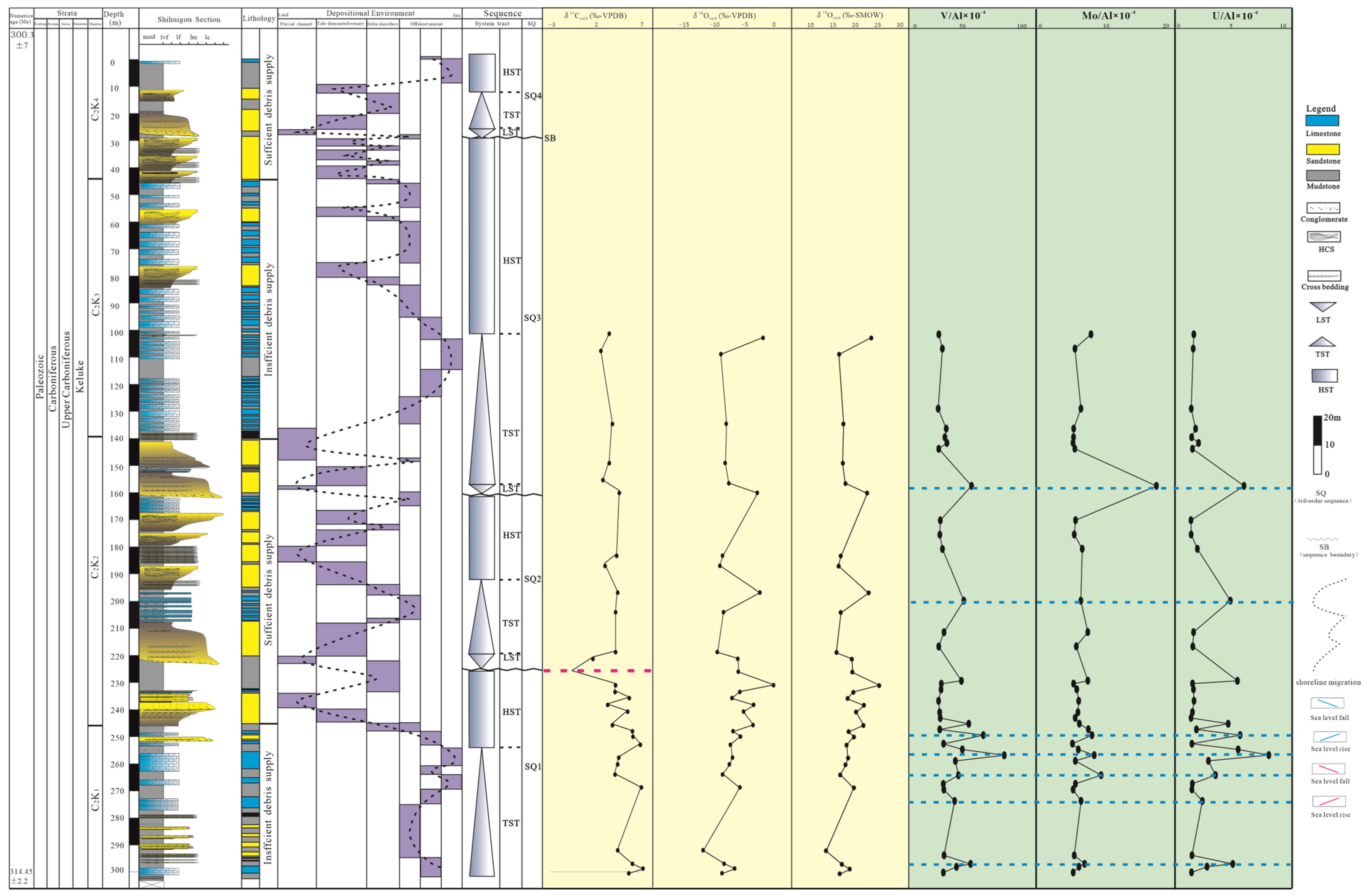
4.1.2. Sequence Stratigraphy Framework

Through detailed outcrop analysis, five major third-order sequence boundaries were identified within the Keluke interval, delineating four distinct sequences (SQ1 to SQ4 from base to top). These sequences are bounded by key stratigraphic surfaces, including sequence boundaries (SBs), transgressive surfaces (TSs), and maximum flooding surfaces (MFSs), each exhibiting diagnostic lithological and sedimentological features. Each third-order sequence comprises three system tracts—the lowstand systems tract (LST), the transgressive systems tract (TST), and the highstand systems tract (HST)—differentiated by changes in facies stacking patterns and depositional trends. The thickness of these system tracts varies across sequences, reflecting differences in accommodation space and sediment supply during deposition.
Sequence Boundary and (Maximum) Transgressive Surface
Sequence boundaries develop when relative sea level falls to its minimum position, which are traceable from subaerial into submarine erosion surfaces. In the mixed clastic–carbonate Keluke strata, the sequence boundaries are recognized as widespread and prominent unconformity surfaces. These surfaces exhibit consistent dip-direction continuity and are typically overlain by fluvial channel conglomerates, indicating a pronounced basinward migration of facies (Figure 8). Extensive rooting and pedogenesis occurred adjacent to the deeper incisions. The fluvial channel successions are truncated by a significant transgressive surface that represents marine transgression and landward shoreline migration, separating the fluvial lowstand deposits from the estuarine transgressive deposits. The maximum flooding surface is recognized as the turning point from landward-stepping to seaward-stepping successions within the marine–proximal portion of the coastal plain. In well-developed estuarine systems, the maximum flooding surface is preserved at the interface between tidal bar complexes and subsequent transgressive sediments.
System Tracts and Third-Order Sequences
Each third-order sequence in the Keluke Formation comprises three distinct system tracts delineated by transgressive surfaces (TS) and maximum flooding surfaces (MFS), detailed as follows. (1) Lowstand systems tracts (LSTs) are characterized by fluvial channel deposits overlying major erosional surfaces. These coarse-grained sediments, including tidally influenced fluvial facies, represent basin-ward shifts during sea level minima. Incised valley fills dominate this tract, with their bases marking maximum regression points. (2) Transgressive systems tracts (TSTs) are composed of landward-stepping estuarine deposits that onlap lowstand sediments. The drowning of fluvial systems during rising sea levels is evidenced by tidal influence in channel deposits and the progressive landward migration of facies. (3) Highstand systems tracts (HSTs) feature aggradational to progradational marine deposits, including offshore sediments overlain by wave-dominated shoreface or tide-influenced deltaic facies. These reflect decreasing rates of sea level rise and subsequent sediment surplus.
The four identified sequences (SQ1–SQ4) exhibit thickness variations (40–110 m) and distinct vertical architectures (Figure 8). SQ1 lacks identifiable LST deposits, potentially due to limited terrigenous sediment supply. Sequences SQ2–SQ4 display complete system tract development. The absence of LST in SQ1 contrasts with well-developed lowstand deposits in subsequent sequences, suggesting changing sediment supply patterns through time.
Generally, LST is dominated by fluvial channels; TST is dominated by tide-dominated estuary and marine deposits; and HST is composed of distal marine deposits and wave-dominated shoreface or tide-influenced delta. The change in sedimentary facies from continental to marine suggests shoreline migration and further reflects the trend of sea level changes (Figure 8).

4.2. Geochemical Characteristics

4.2.1. Carbon and Oxygen Isotope Characteristics

The δ13Ccarb value ranges between −2.40 and 5.40 ‰ VPDB, with a mean value of 2.27 ‰ (Table 1, Figure 9). Generally, the δ13Ccarb value shows an increasing trend upward. In the C2K1 member of the Keluke Formation, the δ13Ccarb values display relatively fewer variations and range from −1.20 ‰ to 2.80 ‰, although two small negative excursions are observed. In the lower part of the C2K2 member, a significant negative δ13Ccarb excursion is found (−2.3 ‰). In contrast, the δ13Ccarb values in the upper part of the C2K2 member and C2K3 member are quite stable, ranging from 1.50 to 5.40 ‰. The δ18Ocarb value ranges between −14.20 and −2.60 ‰, with a mean value of −9.05 ‰, both fluctuating frequently during the Late Carboniferous period. However, the relationship between δ13Ccarb and δ18Ocarb shows an inverse trend, and there is no obvious correlation between the two, suggesting that δ18Ocarb may be influenced by diagenesis and cannot effectively indicate the change in sea level rise and fall.

4.2.2. Elemental Geochemical Characteristics

The U/Al ratio (×10−4) in the Keluke Formation of the Shihuigou section in the eastern Qaidam Basin ranges from 0.246 to 9.007, with a mean value of 1.893 × 10⁻⁴, generally exceeding the average U/Al ratio of Post-Archean Australian Shale (PAAS), 0.31) [44,45], indicating a relative enrichment of the U element (Figure 10). It can be assumed that fractions of U/Al ratios above 3.30 reflect a more reducing environment for their formation [46], and, conversely, represent a relatively more oxidising environment. The study section (Figure 10) shows that the U/Al ratio varies relatively widely from C2K1 to the lower part of C2k2 member, reflecting frequent paleoenvironmental changes. Notably, the steep increase in U/Al values at 297 m depth in the C2k2 member and at the location of the maximum sea level may be directly related to the relative sea-level rise and may represent the location of the initial or maximum sea level; therefore, the inflection point marked by a steep increase in U/Al values can be used as a marker of the point of the relative sea level rise in this paper.
The V/Al ratio (×10−4) varies between 3.63 and 79.43, with a mean value of 17.86 × 10⁻⁴, which is higher than the PAAS standard (15.0) [44,47], and even higher than the Black Sea lagoon in some layers. The V/Al ratio of sediments in sulfur-bearing environments (28.8) [46] compared to the PAAS indicates that V/Al values are relatively reductive for enriched depositional environments (Figure 10). Vertically, the trends of V/Al values are generally consistent with U/Al values, reflecting similar redox condition change processes and paleowater properties and even reflecting similar processes of sea level rise and fall change. In the same way, the steeply increasing V/Al values are labeled as the relative sea level rise in this paper.
The Mo/Al ratio varies from 0.118 to 18.994 (×10−4), and the enrichment is greater than the standard PAAS value (0.10) [44,47]. The trends of Mo/Al values in the longitudinal direction are generally consistent with the trends in U/Al and V/Al values (Figure 10), and the indicated redox conditions change similarly.

5. Discussion

5.1. Sequence Development in Relation to Sea Level Changes

The studied mixed clastic–carbonate succession contains multiple third-order sequence stratigraphic units, and each third-order sequence itself is an indicator of a compound relative sea level change process on the thousand-year scale (kyr), i.e., the abrupt and repetitive m-scale alternation of mixed clastic–carbonate rocks suggests rapid and systematic changes in eustasy. The occurrence of the third-order surfaces is likely a product of a significant relative sea level fall, and the maximum flooding surfaces between the TST and HST are related to the increase in the sea level.
The overall profile from the key studied succession, the Shihuigou section, suggests that the four third-order sequences, SQ1, SQ2, SQ3 and SQ4, within the Keluke Formation are possibly linked to at least four significant sea-level fluctuation events (Figure 8), which suggests that there were at least four obvious sea level rises and falls in the eastern Qaidam Basin during the Late Carboniferous period over tens of million years. SQ1, located at the base of the Keluke succession, experienced a gradual and long-term sea level rise and a rapid sea level fall. SQ2 experienced a short and fast sea level fall to the minimum, followed immediately by a short and gradual period of sea level rise, and then ended with a steady decrease in sea level. In contrast, SQ3 experienced a similar process to SQ2, but each phase of sea level change had a longer duration than SQ2. SQ4 underwent a relatively shorter-term and more rapid process of sea level change.
On a long-term scale, the evolution from the late Early Carboniferous toward the Late Carboniferous into the Early Permian experienced a distinct, rapid sea level fall, followed by a frequently fluctuating but overall rising trend, as evidenced by the lithological assemblage (Figure 11), carbon isotope data, and trace element records. The strata transitioned from the C1h carbonate-dominated succession towards the coal-bearing, mixed clastic–carbonate dominated C2k interval and then evolved into the C2zh carbonate-dominated succession. This sequence exhibits a clear trend of gradually increasing and then decreasing in clastic content, and the depositional environment experienced a transition from a shallow marine environment to alternating from continent and marine environments back to a shallow marine environment again, which was usually accompanied by landward and then seaward migration of the shoreline, representing a rapid sea level fall followed by a fluctuating sea level rise.

5.2. Geochemical Record of Sea Level Changes

The carbon isotopes of ancient marine carbonate rocks mainly reflect the productivity and organic carbon burial. When the sea level rises and the climate is warm, the reef-building organisms flourish, and a large amount of organic matter absorbs δ12C that is buried rapidly. This makes the δ13C content in the water body rise; on the contrary, when the sea level falls and the climate turns cold or extremely hot, the reef-building communities may die out, and the δ12C substituted into the seawater due to oxidative denudation increases, while δ13C is relatively reduced [48]. A positive shift in the δ13C value indicates that the productivity of the ancient ocean is increasing, the sea level is rising, and the climate is warming, whereas a negative shift indicates that the productivity of the ancient ocean decreases, the sea level decreases, and the temperature drops. As δ13Ccarb is influenced by ocean productivity and influenced relatively little by terrigenous derived debris, in this paper, we mainly use δ13Ccarb to record the change in relative sea level. Initiated from the bottom of the Keluke Formation, the δ13C value changes from the lower part of the C2K1 towards C2K2 and C2K3 until the C2K4 member, with a large amplitude and high frequency (Figure 9), reflecting the process of frequent relative sea level rise and fall, in which the negative δ13C excursions may be influenced by the process of sea level fall. In other words, the negative δ13C offsets may represent a process of relative sea level rise. The frequent positive and negative offsets indicate the existence of multiphase sea level rise and fall cycles (Figure 11) in the Late Carboniferous of the eastern Qaidam Basin. Noticeably, the profile sampling data show a significant negative excursion at about 225 m (C2K2) as shown by the pink line, which almost perfectly coincides with the exposed unconformity (third-order sequence boundary) of the SQ2 via field observation (Figure 11), indicating that the regional unconformity (SB2) in the study area may have been caused by sea level fall.
Redox-sensitive trace elements (RSTEs), including Mo, U, and V, serve as reliable indicators of oxygenation conditions in ancient marine environments [11,12]. These elements accumulate differentially under varying redox states, with significant enrichments typically signaling anoxic or euxinic bottom waters [13]. The sedimentary inventory of trace elements originates from two primary sources: terrigenous detrital input and authigenic marine components. To isolate the redox-sensitive authigenic signal, elemental concentrations are commonly normalized to aluminum (X/Al ratios), following established methodologies [46]. Specifically, the ratios of U/Al, V/Al, and Mo/Al provide robust proxies for reconstructing paleoredox conditions, as these elements exhibit distinct geochemical behaviors under different oxygen levels [12,13]. This geochemical approach proves particularly valuable for investigating sea level fluctuations during the Late Carboniferous, as RSTE patterns can track watermass oxygenation changes associated with transgressive–regressive cycles. The degree of RSTE enrichment, when properly normalized, reflects the intensity and persistence of reducing conditions in the depositional environment.
Under aerobic to anaerobic conditions, element U exhibits positive hexavalence and is present mainly as soluble uranyl carbonate [UO2(CO3)34−]; however, under certain reducing conditions, element U is reduced to a positive tetravalent and precipitates into the sediment as crystalline bituminous uraninite [46]. Sulphate-reducing bacteria significantly contribute to the reduction of U ions from n-hexavalent to n-tetravalent, and the intensity of reduction by sulphate-reducing bacteria correlates with the presence of organic matter. Under anaerobic conditions without sulphur, the enrichment of U elements increases with increasing TOC values [49]. In contrast, in sulphide-stagnant environments, the enrichment of U elements shows limited correlation with TOC values, and TOC values do not change significantly with increasing U element concentrations [13].
Vanadium (V) exhibits significantly higher enrichment under reducing conditions than under oxygenated settings [13]. V can precipitate from the water column in two reducing environments: anaerobic conditions with or without sulfur [11]. In the sulfur-free anaerobic environment, humic and fulvic acids promote the reduction of vanadium ions from ortho-pentavalent to ortho-tetravalent, and thus the enrichment of V demonstrates a direct relationship with TOC values. On the contrary, in sulfur-rich stagnant environments, vanadium ions will be reduced from n-quaternary to n-trivalent, and this reaction is largely independent of organic matter, so the enrichment degree of V is not significantly correlated with TOC value.
Under aerobic conditions, elemental molybdenum (Mo) is a conserved element [12]. Under reducing conditions, H2S/HS- converts stable molybdates into active thiomolybdates, which precipitate from the water column [50]. Since H2S/HS- is mainly produced by sulfate-reducing bacterial degradation of organic matter, the degree of Mo enrichment is generally positively correlated with TOC values [13]. However, in sulfur-rich, stagnant depositional settings, the relationship between the degree of Mo enrichment and TOC values is not obvious, as abundant free H2S may enhance Mo accumulation independently of TOC.

5.3. Sedimentological and Geochemical Records of Sea Level Changes

In this case, the variations of U/Al, V/Al and Mo/Al show good similarity, which can indicate that the depositional environment experienced oxidation–reduction–oxidation multiple times during SQ1, SQ2, and SQ3 depositional periods, as indicated by the blue lines (Figure 11), reflecting multiple sea level changes of varying amplitude and frequency. Three of the significant sea level rises almost exactly correspond to the first or maximum flooding surfaces as observed in SQ1 and SQ2 from the vertical lithological profile via outcrop. Overall, four of these sea level changes are significant and of high amplitude in the study area during the deposition of C2K1~C2K3 formations, in which each large cycle contains several secondary cycles. These observations can be verified both in terms of lithology and correlation of carbon and oxygen isotopes and main trace elements.

5.4. Origins of Mixed Clastic–Carbonate Cycles in the Eastern Qaidam Basin

The geochemical results are in accordance with the sedimentological and sequence stratigraphic analyses to a large extent, and they are especially consistent at the points where there were significant sea level rises and falls, which are marked and recognized as sequence boundaries and maximum flooding surfaces. Integrated sedimentological and geochemical evidence from the studied section indicates that the Qaidam Basin underwent high-frequency, high-amplitude eustatic fluctuations during the Late Carboniferous. These sea level variations were characterized by (1) short-term cyclicity, i.e., repeated transgressive–regressive cycles, and (2) a long-term trend of a net rise in sea level.
Integrated analysis of sedimentological, stratigraphic, and geochemical data reveals that the Upper Carboniferous mixed clastic–carbonate successions recorded high-frequency glacio-eustaticic fluctuations during the Gondwana glaciation. These cyclic deposits reflect the following occurrences: (1) eustatic drivers, in which ice volume changes primarily controlled high-amplitude sea level oscillations; and (2) depositional response, during which the alternating stratigraphic architecture documented repeated marine transgression–regression cycles. The global sea level change, with the maximum value reaching approximately ca. 200 m [7,21,51], significantly influenced the depositional environment in the Qaidam Basin and displayed coincidence with the time of the SQ2 sequence boundary in geological time. Each cycle shows evidence of the rise and fall in sea level that, coupled with the magnitude and coincidence with inferred glacio-eustatic cyclothems elsewhere, suggests a glacio-eustatic origin. In other words, the relative sea level fluctuations driven by glacier events probably play a vital role in the formation and evolution of mixed clastic–carbonate succession. This glacio-eustaticic forcing mechanism fundamentally controlled the development of the transitional depositional system, in which ice growth phases promoted carbonate platform exposure and siliciclastic influx, and deglaciation events triggered rapid marine transgression and carbonate production.
However, it is noteworthy that the change from the Keluke Formation to the Zhabusagaxiu Formation is expressed as an obvious change from mixed clastic–carbonate succession into carbonate-dominated succession, reflecting a regional increase in the relative sea level in the eastern Qaidam Basin. However, the global sea level change history [5,52] suggests the opposite, indicating that a global sea level fall happened widely at the transition from the Late Carboniferous to the Early Permian (Figure 11). Integrating consideration of regional tectonic context, it is assumed that the carbonate-dominated deposition was likely the product of regional sea level rise caused by basal subsidence in the eastern Qaidam Basin. This subsidence process may be related to the expansion of the Paleo-Tethys Ocean, which led to the eastern Qaidam Basin receiving extensive, large-scale, and multiple-times marine intrusion during the Late Carboniferous and the Early Permian and thus further led to the formation of thick limestone intervals instead of the mixed clastic–carbonate succession shown in the Keluke Formation.
In summary, the short-term and high-frequency cycles of mixed clastic–carbonate deposition may be linked with the Gondwana glacio-eustasy, and the long-term and low-frequency cycles of mixed clastic–carbonate deposition within the Keluke and Zhabusagaxiu Formations were controlled by tectonic movement and ascribed to the Paleo-Tethys Ocean expansion.
The depositional features in the eastern Qaidam Basin are analogous to the mixed deposition in the neighboring North China block and Tarim Basin during the Late Carboniferous and Permian period. Therefore, reconstruction of sea level history via the mixed clastic–carbonate succession record in the eastern Qaidam Basin during the Late Carboniferous period not only has implications for the eastern Qaidam Basin but is also important for predicting the distribution of the mixed clastic–carbonate succession in the North China Block, Yangzi Block, Tarim Basin, and other areas in Tibet Plateau.

6. Conclusions

This integrated sedimentological, sequence stratigraphic, and geochemical study of the Upper Carboniferous mixed clastic–carbonate successions in the eastern Qaidam Basin provides new insights into the interplay between global glacio-eustatic forcing and regional tectonic evolution during the Late Paleozoic Ice Age. The results have significance not only for understanding basin-scale sedimentary processes but also for reconstructing regional paleogeography and global sea level dynamics.
The Keluke Formation exhibits well-defined cyclic successions composed of fluvial, estuarine, deltaic, shoreface, and marine facies. These are interpreted to reflect high-frequency sea level fluctuations induced by Gondwanan glacio-eustasy, superimposed upon a long-term regional transgressive trend. The subsequent development of the carbonate-rich Zhabusagaxiu Formation during the Early Permian highlights a shift toward increased marine influence, interpreted as a response to regional tectonic subsidence associated with the Paleo-Tethys Ocean expansion. This tectonic overprint over global climatic signals suggests that in regions like the eastern Qaidam Basin, accommodation space and marine incursions were as much a product of geodynamics as of global sea level trends. These findings provide critical analogs for interpreting similar mixed successions in adjacent basins, such as the Tarim Basin and North China Craton.
Geochemical proxies, particularly δ13C carbon and redox-sensitive trace elements, document at least four major high-amplitude sea level fluctuation events in the Late Carboniferous, consistent with global records of glacial–interglacial cycles. These results support the global synchrony of Gondwanan glacio-eustatic signals and offer a valuable dataset from a low-latitude paleo-tropical setting. However, the contrast between regional transgression and global regression during the Carboniferous–Permian transition emphasizes the need to disentangle eustatic and tectonic drivers in paleoclimate and sea level reconstructions. The Qaidam succession thus serves as a reference framework for interpreting mixed depositional systems in other icehouse-period basins globally.
Importantly, this study demonstrates how integrated sedimentological, stratigraphic, and geochemical analyses can reconstruct complex sea level histories and unravel the combined effects of global climatic forcing and regional tectonics. The findings provide not only a clearer picture of Carboniferous basin evolution in the Tibetan Plateau but also a globally relevant analog for deciphering sedimentary responses to icehouse climate conditions in similar geological settings.

Author Contributions

Conceptualization, X.W. and Y.L.; methodology, Y.L.; data curation, K.L.; writing—original draft preparation, Y.L. and X.W.; writing—review and editing, Y.L. and X.W.; visualization, K.Q.; project administration, X.W.; funding acquisition, X.W. and Y.L. All authors have read and agreed to the published version of the manuscript.

Funding

This work was supported by the National Natural Science Foundation of China (grant no. 41702124, 41602125, 41772272) who financially supported the field trip and the experimental test analysis costs.

Data Availability Statement

The original contributions presented in this study are included in the article. Further inquiries can be directed to the corresponding author.

Acknowledgments

We thank Longyi Shao, Shiyue Chen, and the three anonymous reviewers for their valuable comments on the topic.

Conflicts of Interest

Author Kening Qi was employed by the company Zhongyuan Oilfield Company, SINOPEC. The remaining authors declare that the research was conducted in the absence of any commercial or financial relationships that could be construed as a potential conflict of interest.

References

  1. Tucker, M.E. Mixed clastic–carbonate cycles and sequences: Quaternary of Egypt and Carboniferous of England. Geol. Croat. 2003, 56, 19–37. [Google Scholar] [CrossRef]
  2. Coffey, B.P.; Read, J.F. Mixed carbonate–siliciclastic sequence stratigraphy of a Paleogene transition zone continental shelf, southeastern USA. Sediment. Geol. 2004, 166, 21–57. [Google Scholar] [CrossRef]
  3. Seyedmehdi, Z.; George, A.D.; Tucker, M.E. Sequence development of a latest Devonian–Tournaisian distally-steepened mixed carbonate–siliciclastic ramp, Canning Basin, Australia. Sediment. Geol. 2016, 333, 164–183. [Google Scholar] [CrossRef]
  4. Eriksson, K.A.; McClung, W.S.; Simpson, E.L. Sequence stratigraphic expression of greenhouse, transitional and icehouse conditions in siliciclastic successions: Paleozoic examples from the central Appalachian basin, USA. Earth Sci. Rev. 2019, 188, 176–189. [Google Scholar] [CrossRef]
  5. Rygel, M.C.; Fielding, C.R.; Frank, T.D.; Birgenheier, L.P. The magnitude of Late Paleozoic glacioeustatic fluctuations: A synthesis. J. Sediment. Res. 2008, 78, 500–511. [Google Scholar] [CrossRef]
  6. Garrett, E.; Barlow, N.L.M.; Cool, H.; Kaufman, D.S.; Shennan, I.; Zander, P.D. Constraints on regional drivers of relative sea-level change around Cordova, Alaska. Quat. Sci. Rev. 2015, 113, 48–59. [Google Scholar] [CrossRef]
  7. Rankey, E.C. Relations between relative changes in sea level and climate shifts: Pennsylvanian–Permian mixed carbonate-siliciclastic strata, western United States. Geol. Soc. Am. Bull. 1997, 109, 1089–1100. [Google Scholar] [CrossRef]
  8. Isaack, A.; Gischler, E.; Hudson, J.H.; Anselmetti, F.S.; Lohner, A.; Vogel, H.; Garbode, E.; Camoin, G.F. A new model evaluating Holocene sediment dynamics: Insights from a mixed carbonate–siliciclastic lagoon (Bora Bora, Society Islands, French Polynesia, South Pacific). Sediment. Geol. 2016, 343, 99–118. [Google Scholar] [CrossRef]
  9. Emerson, S.; Hedges, J. Chemical Oceanography and the Marine Carbon Cycle; Cambridge University Press: Cambridge, UK, 2008. [Google Scholar]
  10. Li, Y.; Zhang, T.; Ellis, G.S.; Shao, D. Depositional environment and organic matter accumulation of Upper Ordovician–Lower Silurian marine shale in the Upper Yangtze Platform, South China. Palaeogeogr. Palaeoclimatol. Palaeoecol. 2017, 466, 252–264. [Google Scholar] [CrossRef]
  11. Morford, J.L.; Emerson, S. The geochemistry of redox sensitive trace metals in sediments. Geochim. et Cosmochim. Acta 1999, 63, 1735–1750. [Google Scholar] [CrossRef]
  12. Algeo, T.J.; Lyons, T.W. Mo–total organic carbon covariation in modern anoxic marine environments: Implications for analysis of paleoredox and paleohydrographic conditions. Paleoceanography 2006, 21, 1–23. [Google Scholar] [CrossRef]
  13. Tribovillard, N.; Algeo, T.J.; Lyons, T.; Riboulleau, A. Trace metals as paleoredox and paleoproductivity proxies: An update. Chem. Geol. 2006, 232, 12–32. [Google Scholar] [CrossRef]
  14. Plint, A.G. High-frequency relative sea-level oscillations in Upper Cretaceous shelf clastics of the Alberta foreland basin: Possible evidence for a glacio-eustatic control? Sediment. Tecton. Eustasy Sea-Level Changes Act. Margins 1991, 409–428. [Google Scholar] [CrossRef]
  15. Liu, K.; Li, Z.; Shi, X.; Wei, X.; Ren, Z.; Yang, X.; Peng, B. Late Hercynian-Indosinian denudation and uplift history in the eastern Qaidam Basin: Constraints from multiple thermometric indicators and sedimentary evidences. Chin. J. Geophys. 2020, 63, 1403–1421. (In Chinese) [Google Scholar]
  16. Chen, S.; Bi, M.; Sun, J.; Zhang, Y.; Zhuang, Y. Mixed sedimentary characteristics and controlling factors of Upper Paleozoic Group in Northern Qaidam Basin. Geol. Bull. China 2016, 35, 282–292. [Google Scholar]
  17. Yin, A.; Harrison, T.M. Geologic evolution of the Himalayan-Tibetan orogen. Annu. Rev. Earth Planet. Sci. 2000, 28, 211–280. [Google Scholar] [CrossRef]
  18. Tapponnier, P.; Zhiqin, X.; Roger, F.; Meyer, B.; Arnaud, N.; Wittlinger, G.; Jingsui, Y. Oblique stepwise rise and growth of the Tibet Plateau. Science 2001, 294, 1671–1677. [Google Scholar] [CrossRef]
  19. Fielding, C.R.; Frank, T.D.; Isbell, J.L. The late Paleozoic ice age—A review of current understanding and synthesis of global climate patterns. In Special Paper 441: Resolving the Late Paleozoic Ice Age in Time and Space; Geological Society of America Special Publication: Boulder, CO, USA, 2008. [Google Scholar]
  20. Isbell, J.L.; Henry, L.C.; Gulbranson, E.L.; Limarino, C.O.; Fraiser, M.L.; Koch, Z.J.; Ciccioli, P.L.; Dineen, A.A. Glacial paradoxes during the late Paleozoic ice age: Evaluating the equilibrium line altitude as a control on glaciation. Gondwana Res. 2012, 22, 1–19. [Google Scholar] [CrossRef]
  21. Metcalfe, I. Gondwana dispersion and Asian accretion: Tectonic and palaeogeographic evolution of eastern Tethys. J. Asian Earth Sci. 2013, 66, 1–33. [Google Scholar] [CrossRef]
  22. Torsvik, T.H.; Cocks, L.R.M. Earth History and Palaeogeography; Cambridge University Press: Cambridge, UK, 2017. [Google Scholar]
  23. Heckel, P.H. Pennsylvanian cyclothems in Midcontinent North America as far-field effects of waxing and waning of Gondwana ice sheets. In Special Paper 441: Resolving the Late Paleozoic Ice Age in Time and Space; Geological Society of America Special Publication: Boulder, CO, USA, 2008. [Google Scholar]
  24. Dalrymple, R.W. Tidal depositional systems. In Facies Models Response to Sea-Level Change; Geological Association of Canada: St. John’s, NL, Canada, 1992; pp. 195–218. [Google Scholar]
  25. Reineck, H.-E.; Singh, I.B. Depositional Sedimentary Environments: With Reference to Terrigenous Clastics; Springer Science & Business Media: Berlin/Heidelberg, Germany, 2012. [Google Scholar]
  26. Wachter, E.A.; Hayes, J.M. Exchange of oxygen isotopes in carbon dioxide-phosporic acid systems. Chem. Geol. Isot. Geosci. Sect. 1985, 52, 365–374. [Google Scholar] [CrossRef]
  27. Catuneanu, O.; Abreu, V.; Bhattacharya, J.P.; Blum, M.D.; Dalrymple, R.W.; Eriksson, P.G.; Fielding, C.R.; Fisher, W.L.; Galloway, W.E.; Gibling, M.R.; et al. Towards the standardization of sequence stratigraphy. Earth Sci. Rev. 2009, 92, 1–33. [Google Scholar] [CrossRef]
  28. Van Wagoner, J.C.; Mitchum, R.M.; Campion, K.M.; Rahmanian, V.D. Siliciclastic Sequence Stratigraphy in Well Logs, Cores, and Outcrops: Concepts for High-Resolution Correlation of Time and Facies; American Association of Petroleum Geologists: Tulsa, OK, USA, 1990. [Google Scholar]
  29. Sarg, J. Carbonate Sequence Stratigraphy; American Association of Petroleum Geologists: Tulsa, OK, USA, 1988. [Google Scholar]
  30. Algeo, T.J.; Tribovillard, N. Environmental analysis of paleoceanographic systems based on molybdenum–uranium covariation. Chem. Geol. 2009, 268, 211–225. [Google Scholar] [CrossRef]
  31. Dalrymple, R.W.; Choi, K. Morphologic and facies trends through the fluvial–marine transition in tide-dominated depositional systems: A schematic framework for environmental and sequence-stratigraphic interpretation. Earth Sci. Rev. 2007, 81, 135–174. [Google Scholar] [CrossRef]
  32. Dalrymple, R.W.; Zaitlin, B.A. High-resolution sequence stratigraphy of a complex, incised valley succession, Cobequid Bay—Salmon River estuary, Bay of Fundy, Canada. Sedimentology 1994, 41, 1069–1091. [Google Scholar] [CrossRef]
  33. Owen, G. Experimental soft-sediment deformation: Structures formed by the liquefaction of unconsolidated sands and some ancient examples. Sedimentology 1996, 43, 279–293. [Google Scholar] [CrossRef]
  34. Ainsworth, R.B.; Vakarelov, B.K.; Eide, C.H.; Howell, J.A.; Bourget, J. Linking the high-resolution architecture of modern and ancient wave-dominated deltas: Processes, products, and forcing factors. J. Sediment. Res. 2019, 89, 168–185. [Google Scholar] [CrossRef]
  35. Longhitano, S.G.; Mellere, D.; Steel, R.J.; Ainsworth, R.B. Tidal depositional systems in the rock record: A review and new insights. Sediment. Geol. 2012, 279, 2–22. [Google Scholar] [CrossRef]
  36. Wei, X.; Steel, R.J.; Ravnås, R.; Jiang, Z.; Olariu, C.; Ma, Y. Anatomy of anomalously thick sandstone units in the Brent Delta of the northern North Sea. Sediment. Geol. 2018, 367, 114–134. [Google Scholar] [CrossRef]
  37. Plink-Björklund, P. Stacked fluvial and tide-dominated estuarine deposits in high-frequency (fourth-order) sequences of the Eocene Central Basin, Spitsbergen. Sedimentology 2005, 52, 391–428. [Google Scholar] [CrossRef]
  38. Bhattacharya, J.P.; Giosan, L. Wave-influenced deltas: Geomorphological implications for facies reconstruction. Sedimentology 2003, 50, 187–210. [Google Scholar] [CrossRef]
  39. Dott Jr, R.; Bourgeois, J. Hummocky stratification: Significance of its variable bedding sequences. Geol. Soc. Am. Bull. 1982, 93, 663–680. [Google Scholar] [CrossRef]
  40. Duke, W.L. Hummocky cross-stratification, tropical hurricanes, and intense winter storms. Sedimentology 1985, 32, 167–194. [Google Scholar] [CrossRef]
  41. Dumas, S.; Arnott, R. Origin of hummocky and swaley cross-stratification—The controlling influence of unidirectional current strength and aggradation rate. Geology 2006, 34, 1073–1076. [Google Scholar] [CrossRef]
  42. Wei, X.; Steel, R.J.; Ravnås, R.; Jiang, Z.; Olariu, C.; Li, Z. Variability of tidal signals in the Brent Delta Front: New observations on the Rannoch Formation, northern North Sea. Sediment. Geol. 2016, 335, 166–179. [Google Scholar] [CrossRef]
  43. Collins, L.B. Sediments and history of the Rottnest Shelf, southwest Australia: A swell-dominated, non-tropical carbonate margin. Sediment. Geol. 1988, 60, 15–49. [Google Scholar] [CrossRef]
  44. Taylor, S.R.; McLennan, S.M. The Continental Crust: Its Composition and Evolution; Blackwell Scientific Publications: Oxford, UK, 1985. [Google Scholar]
  45. Li, Y.; Fan, T.; Zhang, J.; Zhang, J.; Wei, X.; Hu, X.; Zeng, W.; Fu, W. Geochemical changes in the Early Cambrian interval of the Yangtze Platform, South China: Implications for hydrothermal influences and paleocean redox conditions. J. Asian Earth Sci. 2015, 109, 100–123. [Google Scholar] [CrossRef]
  46. Calvert, S.; Pedersen, T. Geochemistry of recent oxic and anoxic marine sediments: Implications for the geological record. Mar. Geol. 1993, 113, 67–88. [Google Scholar] [CrossRef]
  47. McLennan, S.; Hemming, S.; McDaniel, D.K.; Hanson, G.N. Geochemical approaches to sedimentation, provenance, and tectonics. In Processes Controlling the Composition of Clastic Sediments; Geological Society of America Special Publication: Boulder, CO, USA, 1993. [Google Scholar]
  48. Li, Y.; Zhang, T.; Shao, D.; Shen, B. New U-Pb zircon age and carbon isotope records from the Lower Silurian Longmaxi Formation on the Yangtze Platform, South China: Implications for stratigraphic correlation and environmental change. Chem. Geol. 2019, 509, 249–260. [Google Scholar] [CrossRef]
  49. Algeo, T.J.; Maynard, J.B. Trace-element behavior and redox facies in core shales of Upper Pennsylvanian Kansas-type cyclothems. Chem. Geol. 2004, 206, 289–318. [Google Scholar] [CrossRef]
  50. Helz, G.; Miller, C.V.; Charnock, J.M.; Mosselmans, J.F.W.; Pattrick, R.A.D.; Garner, C.D.; Vaughan, D.J. Mechanism of molybdenum removal from the sea and its concentration in black shales: EXAFS evidence. Geochim. Cosmochim. Acta 1996, 60, 3631–3642. [Google Scholar] [CrossRef]
  51. Isbell, J.L.; Lenaker, P.A.; Askin, R.A.; Miller, M.F.; Babcock, L.E. Reevaluation of the timing and extent of late Paleozoic glaciation in Gondwana: Role of the Transantarctic Mountains. Geology 2003, 31, 977–980. [Google Scholar] [CrossRef]
  52. Haq, B.U.; Schutter, S.R. A chronology of Paleozoic sea-level changes. Science 2008, 322, 64–68. [Google Scholar] [CrossRef]
Figure 1. (A) Geological map of the eastern Qaidam Basin and surrounding areas, modified from Liu et al. (2020) [15]. The study area is indicated by the box. (B) Tectonic sketch of the eastern Qaidam Basin, modified from Chen et al. (2016) [16]. Red dots indicate sections where mixed clastic–carbonate strata developed.
Jmse 13 01299 g001
Figure 2. Stratigraphic division in the eastern Qaidam Basin during the Carboniferous–Permian period, modified from Chen et al. (2016) [16]. The studied interval is marked by a pink box.
Jmse 13 01299 g002
Figure 3. Example of mixed clastic–carbonate succession of the Upper Carboniferous strata in the eastern Qaidam Basin (a case from Shihuigou section): (A) original picture of mixed clastic–carbonate interval; (B) schematic depiction of a typical mixed interval; (C) vertical succession of mixed clastic–carbonate deposits in C2K2 formation of Shihuigou section, showing varying arrangements of clastic and carbonate rocks. The interval within the pink box corresponds to images (A,B).
Jmse 13 01299 g003
Figure 4. Characteristics of the tide-dominated estuary and its vertical succession in the eastern Qaidam Basin. (A) Overall succession of the tide-dominated estuary consisting of compound dunes (compound dunes 1 and 2), each comprising low-angle, finer-grained bottomsets and upward-coarsening, higher-angle foresets); (B) coarse-grained channel deposits; (C) unidirectional cross-bedding; (D) stacked compound cross-bedding exhibiting frequent changes of flow direction (as observed in sets 1 and 2, sets 3 and 4 etc.), interpreted as the product of alternating flood and ebb tidal currents; (E) vertical succession of the tide-dominated estuary and its overlying and underlying deposits.
Jmse 13 01299 g004
Figure 5. Typical characteristics of the tide-influenced delta and its vertical succession in the eastern Qaidam Basin. (A,B) Plain view of tide-influenced delta; (C) tidal signatures: lenticular-wavy-flaser bedding and (D) ripple lamination; (E) tidal signature: compound dunes expressed as well-organized stacked cross-bedding. The white lines mark foresets of the dunes, and red lines represent reactivation surfaces; (F) interbedded sandstones and mudstones; (G) overall vertical succession of tide-influenced delta. (H) The overall vertical evolution of the tide-influenced delta system shows a transition from a mud-dominated delta-front upward into a sand-dominated delta-plain, followed by an interval of alternating sand and mud representing the interdistributary delta plain, and finally grading into sand-rich fluvial channel deposits, which are capped by a carbonate-dominated interval.
Jmse 13 01299 g005
Figure 6. Characteristics of wave-dominated shoreface and its vertical succession in the eastern Qaidam Basin: (A) amalgamated hummocky cross-stratified sandstone, interpreted as the middle to upper shoreface; (B) storm-wave signature: hummocky and swaley cross-strata; (C) interbedded fine-grained sandstone and mudstone interpreted, as a transition zone; and (D) wave ripples and HCS.
Jmse 13 01299 g006
Figure 7. Characteristics of mixed carbonate- and mudstone-dominated offshore marine deposits and their different stacking patterns in the eastern Qaidam Basin: (A1,A2) interbedded thick-bedded limestone and mudstone with local coal layers, representing proximal offshore marine deposits below the fair-weather wave base; (B1,B2) interbedded thin-bedded mudstone and mudstone; (C1,C2) mudstone-dominated interval with thin limestone layers, representing distal offshore marine deposits below the storm wave base. (D) overall vertical succession of the carbonate-dominated shallow marine environment.
Jmse 13 01299 g007
Figure 8. Sequence stratigraphy of the Upper Carboniferous strata in the eastern Qaidam Basin. Five sequence boundaries (SB) were identified and subdivide the Upper Carboniferous into four third-order sequences, SQ1, SQ2, SQ3, and SQ4. LST is absent fro SQ1. SQ2, SQ3 and SQ4 consist of LST, TST and HST, respectively. Generally, LST is dominated by fluvial channels; TST is dominated by tide-dominated estuary and marine deposits; and HST is composed of distal marine deposits and wave-dominated shoreface or tide-influenced delta. The change in sedimentary facies from continental to marine suggests shoreline migration and further reflects the trend of sea level rise and fall.
Jmse 13 01299 g008
Figure 9. Relative sea level changes indicated by carbon and oxygen isotope. Influenced by diagenesis, there is no significant correlation between δ13C and δ18O. δ13C is primarily used to record the changes in relative sea level. Pink lines mark significant sea level falls. Multiple sea level falls are recorded by carbon isotope excursions.
Jmse 13 01299 g009
Figure 10. Relative sea level changes recorded by redox sensitive trace elements (RSTEs): V, Mo and U. The RSTEs exhibit similar trends and the inflection points of steep increases in V/Al, Mo/Al, and U/Al ratios are used as indicators of relative sea level rise in this study. Blue lines denote significant sea level rise events.
Jmse 13 01299 g010
Figure 11. Comprehensive study of relative sea level changes reflected by sequence stratigraphy, carbon and oxygen isotopes, and trace elements. The five sequence boundaries basically correspond to the inflection points of steep decreases in the δ13C, indicating the maximum sea level fall events. The positions of maximum flooding surfaces also almost correspond to the positions of the turning points of steep increases in RSTE values, representing the maximum sea level rise events. Overall, four significant sea level rise and fall events are identified, as shown above.
Jmse 13 01299 g011
Table 1. Isotopic data and elemental proxies from Shihuigou section of the eastern Qaidam Basin.
SampleMemberLithologyDepth (m)δ13Ccarb
(‰, VPDB)
δ18Ocarb
(‰, VPDB)
V/Al
× 10−4
Mo/Al
× 10−4
U/Al
× 10−4
shg2016310101C2K3Mudstone2983.80−11.109.560.300.31
shg2016310102Limestone2965.40−9.0024.571.572.06
shg2016310103Limestone2954.20−10.8040.812.864.96
shg2016310104Siltstone2922.60−14.2010.350.510.36
shg2016310105Limestone2735.20−8.2022.522.051.53
shg2016310106Siltstone2692.30−11.0010.130.260.35
shg2016310107Mudstone2672.60−9.909.460.780.40
shg2016310108C2K2Limestone2642.70−9.4026.876.573.01
shg2016310109Limestone2595.10−9.7023.350.772.22
shg2016310110Limestone2574.30−8.1079.435.029.01
shg2016310111Limestone2554.20−9.3031.311.445.56
shg2016310112Coal2532.00−6.009.740.120.35
shg2016310113Limestone2503.70−7.6055.484.525.78
shg2016320101Sandstone2481.50−5.905.413.700.86
shg2016320102Limestone2463.90−9.5038.701.664.44
shg2016320103Sandstone2442.30−8.205.980.730.26
shg2016320104Sandstone2422.40−2.605.311.340.41
shg2016320105Sandstone238−2.40−8.404.011.510.59
shg2016320107Siltstone234−0.10−8.506.901.090.53
shg2016320108Siltstone2322.40−11.907.210.370.42
shg2016330101C2K1Limestone2312.40−10.9030.293.585.48
shg2016330102Sandstone2192.60−4.904.260.970.46
shg2016330104Sandstone2141.20−11.5010.273.560.54
shg2016330105Limestone2032.50−11.0033.062.014.68
shg2016330106Mudstone1852.80−5.308.492.320.97
shg2016330107Limestone1801.00−10.005.500.510.27
shg2016330108Sandstone1751.70−10.606.010.820.25
shg2016330109Limestone1632.00−10.4041.9018.996.21
shg2016340101Sandstone1502.00−5.304.220.650.42
shg2016340102Limestone1481.90−10.0013.610.251.11
shg2016340103Mudstone1461.00−11.1011.250.360.33
shg2016340104Siltstone1430.80−11.3012.850.390.77
shg2016340105Sandstone1361.70−4.403.632.010.28
shg2016340107Mudstone115−0.90−9.008.440.680.50
shg2016360101Sandstone110−1.20−11.604.304.280.58
Disclaimer/Publisher’s Note: The statements, opinions and data contained in all publications are solely those of the individual author(s) and contributor(s) and not of MDPI and/or the editor(s). MDPI and/or the editor(s) disclaim responsibility for any injury to people or property resulting from any ideas, methods, instructions or products referred to in the content.

