
The Central Western Caucasus at the Jurassic–Cretaceous Transition: A Synthesis with a Case Study


Abstract
1. Introduction
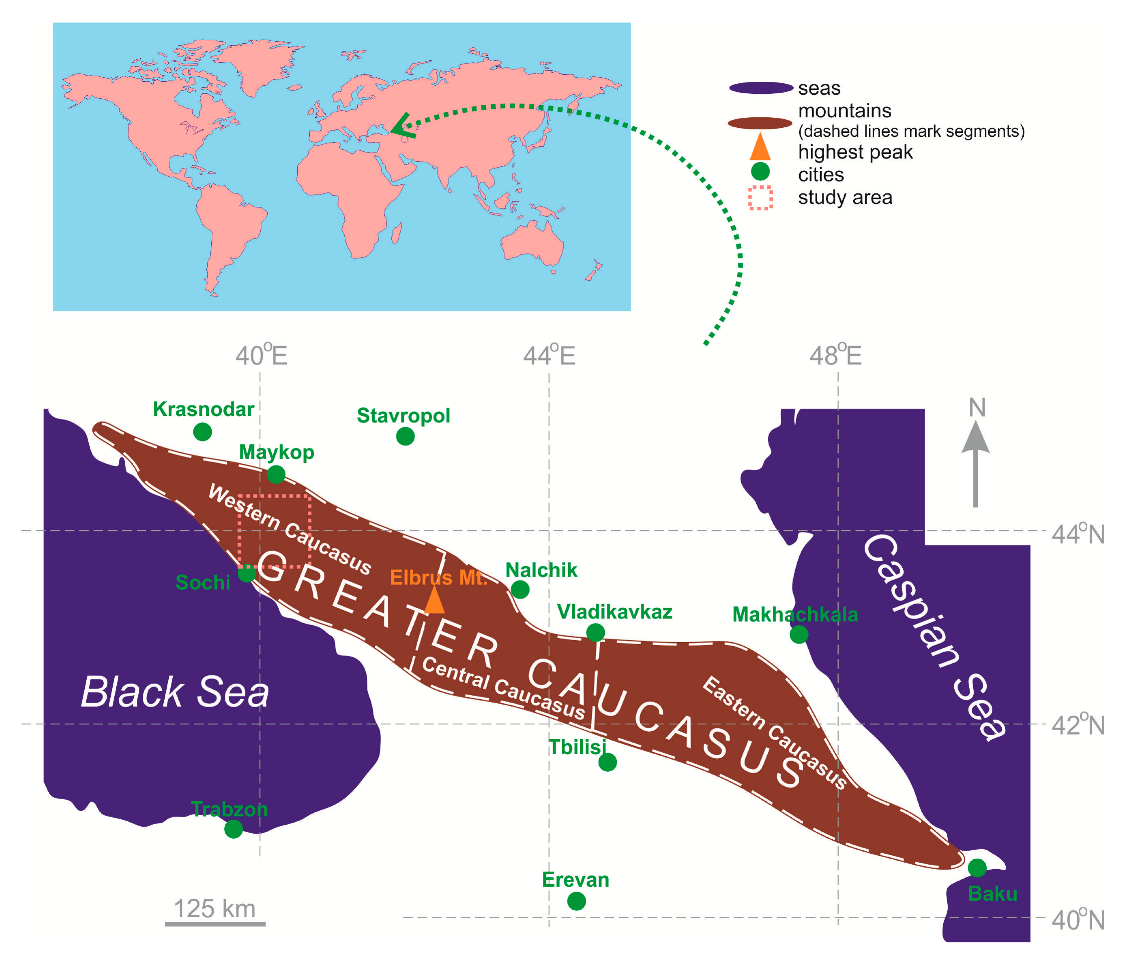
2. Geological Setting
3. Synthesis of Literary Evidence
3.1. Key Sources and Procedures
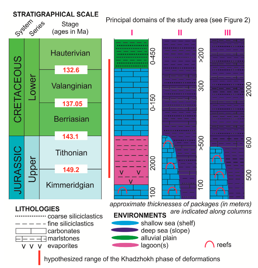
3.2. Generalized Vision of Kimmeridgian–Hauterivian Deposits
4. Case Study: Composition of Hauterivian Sandstones
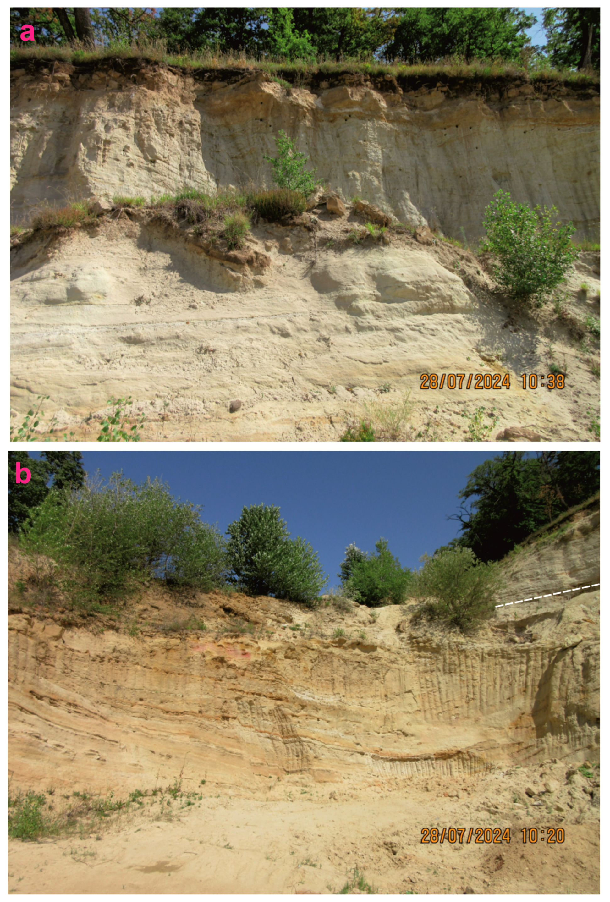
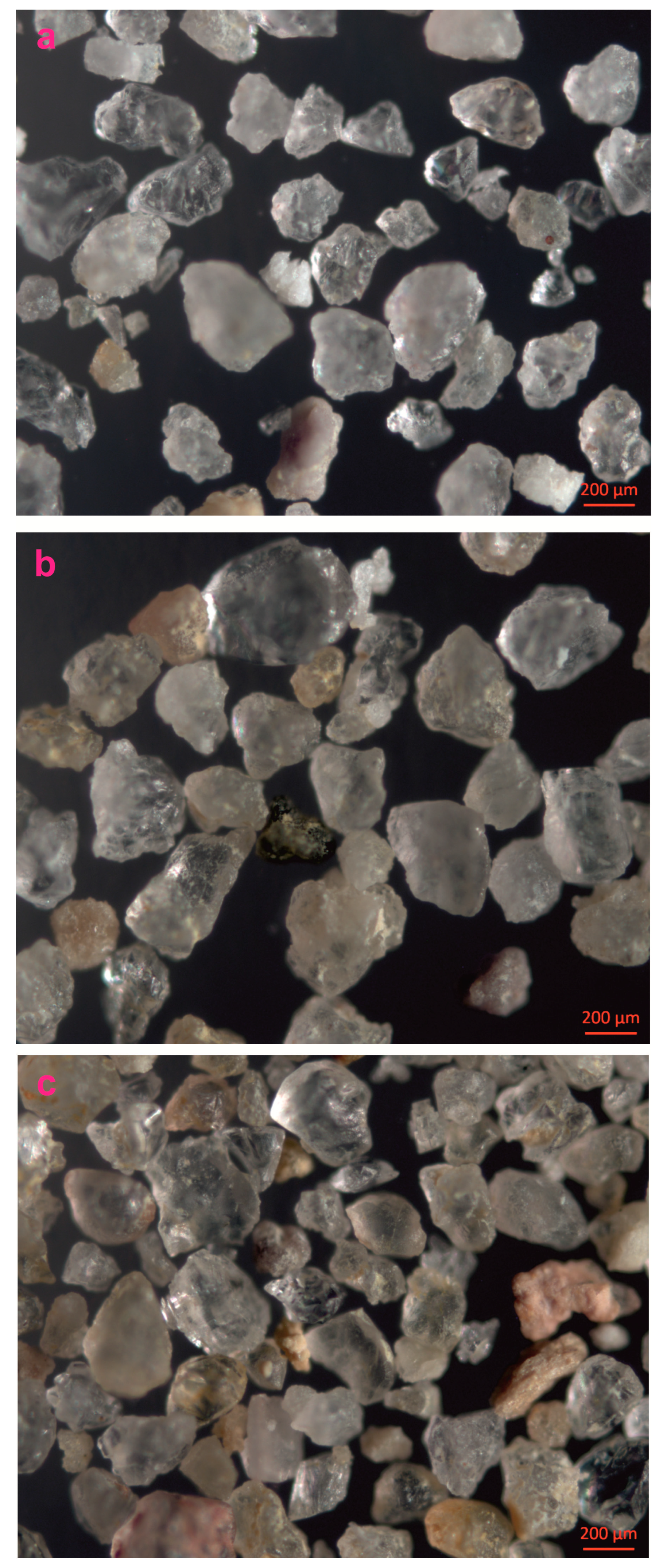
4.1. Material and Procedures
4.2. Results
5. Discussion
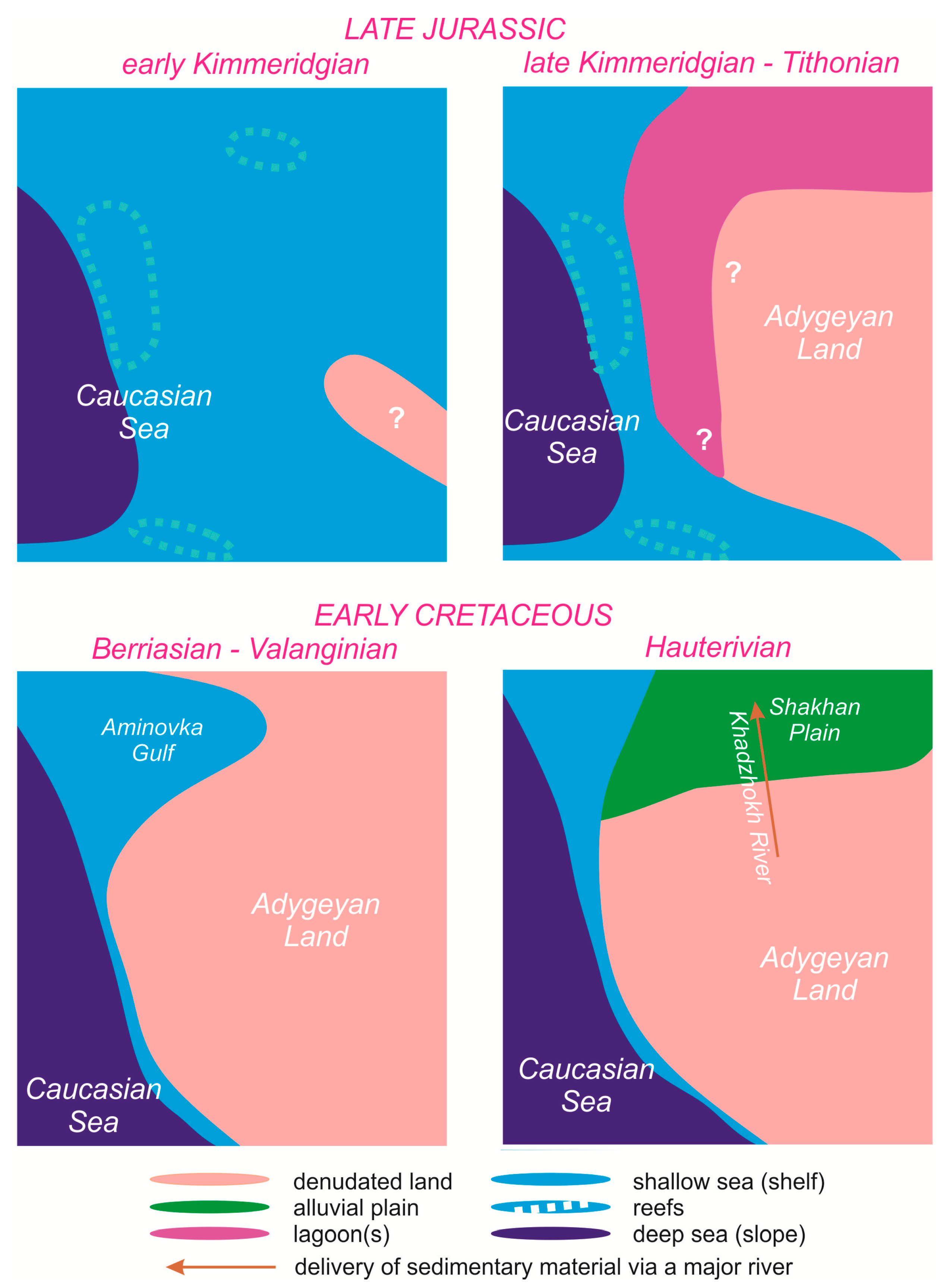
5.1. Tentative Paleogeographic Model
5.2. Possible Factors of Paleogeographical Changes
5.3. Paleogeographical Hypothesis for Further Verification
6. Conclusions
Author Contributions
Funding
Data Availability Statement
Acknowledgments
Conflicts of Interest
References
- Barrier, E.; Vrielynck, B.; Brouillet, J.F.; Brunet, M.F. Paleotectonic Reconstruction of the Central Tethyan Realm. In Tectono-Sedimentary-Palinspastic Maps from Late Permian to Pliocene. Atlas of 20 Maps; CGMW/CCGM: Paris, France, 2018. [Google Scholar]
- Golonka, J. Plate tectonic evolution of the southern margin of Eurasia in the Mesozoic and Cenozoic. Tectonophysics 2004, 381, 235–273. [Google Scholar] [CrossRef]
- Scotese, C.R. An Atlas of Phanerozoic Paleogeographic Maps: The Seas Come In and the Seas Go Out. Annu. Rev. Earth Planet. Sci. 2021, 49, 679–728. [Google Scholar] [CrossRef]
- Adamia, S.; Alania, V.; Chabukiani, A.; Kutelia, Z.; Sadradze, N. Great Caucasus (Cavcasioni): A long-lived North-Tethyan back-arc basin. Turk. J. Earth Sci. 2011, 20, 611–628. [Google Scholar] [CrossRef]
- Ruban, D.A. Islands in the Caucasian Sea in Three Mesozoic Time Slices: Novel Dimension of Geoheritage and Geotourism. J. Mar. Sci. Eng. 2022, 10, 1330. [Google Scholar] [CrossRef]
- Baraboshkin, E.Y.; Alekseev, A.S.; Kopaevich, L.F. Cretaceous palaeogeography of the North-Eastern Peri-Tethys. Palaeogeogr. Palaeoclimatol. Palaeoecol. 2003, 196, 177–208. [Google Scholar] [CrossRef]
- Drushits, V.V.; Mikhailova, I.A. Biostratigraphy of the Lower Cretaceous of the Northern Caucasus; MGU: Moscow, Russia, 1966. (In Russian) [Google Scholar]
- Guo, L.; Vincent, S.J.; Lavrishchev, V. Upper Jurassic Reefs from the Russian Western Caucasus: Implications for the Eastern Black Sea. Turk. J. Earth Sci. 2011, 20, 629–653. [Google Scholar] [CrossRef]
- Yasamanov, N.A. Landscape-Climatic Conditions of the Jurassic, the Cretaceous and the Paleogene of the South of the USSR; Nedra: Moscow, Russia, 1978. (In Russian) [Google Scholar]
- Forte, A.M.; Gutterman, K.R.; van Soest, M.C.; Gallagher, K. Building a Young Mountain Range: Insight Into the Growth of the Greater Caucasus Mountains From Detrital Zircon (U-Th)/He Thermochronology and 10Be Erosion Rates. Tectonics 2022, 41, e2021TC006900. [Google Scholar] [CrossRef]
- Kolodyazhny, S.Y.; Kuznetsov, N.B.; Makhinya, E.I.; Shalaeva, E.A.; Dantsova, K.I.; Romanyuk, T.V.; Antipov, M.P.; Parfenov, G.E. Tectono-Gravitational Detachments in the Alpine Cover of the Northern Slope of the Greater Caucasus and Western Pre-Caucasus Basin (Adygean Segment). Geotectonics 2024, 58, 611–638. [Google Scholar] [CrossRef]
- Makeev, V.M.; Revazov, M.O.; Pikulik, E.A.; Fikri, E.A. Structures of the alpine orogenesis southern slope of the Greater Caucasus Western segment related to the ensuring safety of engineering sites. Geol. I Geofiz. Yuga Ross. 2024, 14, 39–53. [Google Scholar]
- Vasey, D.A.; Garcia, L.; Cowgill, E.; Trexler, C.C.; Godoladze, T. Episodic evolution of a protracted convergent margin revealed by detrital zircon geochronology in the Greater Caucasus. Basin Res. 2024, 36, e12825. [Google Scholar] [CrossRef]
- Zelenin, E.; Garipova, S. Geological History and Active Tectonics of European Russia. Dokl. Earth Sci. 2024, 519, S7–S13. [Google Scholar] [CrossRef]
- Korsakov, S.G.; Semenukha, I.N.; Beluzhenko, E.V.; Chernykh, V.I.; Tuzikov, G.R.; Grekov, I.I.; Tokarev, V.N.; Derkacheva, M.G.; Sokolov, V.V. State Geological Map of Russian Federation of the Scale 1:200,000. Caucasian series. Maykop. Explanatory note; Russian Geological Research Institute: Saint Petersburg, Russia, 2004. (In Russian) [Google Scholar]
- Giorgobiani, T.V. Conditions of formation of the Alpine folded system of the Greater Caucasus and unique features of it’s structure. Geol. I Geofiz. Yuga Ross. 2019, 9, 43–57. [Google Scholar]
- Kushcheva, Y.V.; Latysheva, I.V.; Golovin, D.I.; Gavrilov, Y.O. Textural-structural, mineralogical, isotopic, and age characteristics of Jurassic terrigenous rocks of the northwestern Caucasus (the Belaya River section). Lithol. Miner. Resour. 2007, 43, 257–267. [Google Scholar] [CrossRef]
- Andreev, V.M. Stratigraphic scheme of the Caucasus Black Sea coast. In Geology and Biodiversity of the Mesozoic–Cenozoic Deposits of the Russian South; Pinchuk, T.N., Ed.; Tetis: Goryachiy Klyuch, Russia, 2015; pp. 4–10. (In Russian) [Google Scholar]
- Goryacheva, A.A.; Zorina, S.O.; Ruban, D.A. New palynological data from the Upper Jurassic deposits of the Western Caucasus. Vestn. Udmurt. universiteta. Ser. Biologija. Nauk. O Zemle 2022, 4, 449–459. (In Russian) [Google Scholar] [CrossRef]
- Egoyan, V.L. Tectonic development of the Western Ciscaucasus and the North-Western Caucasis in the Cretaceous Period. In Osobennosti Geologicheskogo Stroeniya i Neftegazonosnosti Predkavka’ya i Sopredel’nykh Rayonov; Nauka: Moscow, Russia, 1965; pp. 112–130. (In Russian) [Google Scholar]
- Egoyan, V.L.; Tkachuk, G.A. To the stratigraphy of the Hauterivian of the Northern Caucasus. Tr. KFVNIInetf’ 1965, 16, 244–285. (In Russian) [Google Scholar]
- Luppov, N.P. Lower Cretaceous Deposits of the North-Western Caucasus and Their Fauna; Gostoptekhizdat: Moscow, Russia, 1952. (In Russian) [Google Scholar]
- Mikhailenko, A.V.; Ruban, D.A. Geosites of Northern Mountainous Adygeya (Southwestern Russia): A Novel Vision. Geosciences 2024, 14, 249. [Google Scholar] [CrossRef]
- Mordvilko, T.N. Lower Cretaceous Deposits of the Morthern Caucasus and the Ciscaucasus; Izdatel’stvo Akademii nauk SSSR: Moscow, Russia, 1960. (In Russian) [Google Scholar]
- Rostovtsev, K.O.; Agaev, V.B.; Azarian, N.R.; Babaev, R.G.; Besnosov, N.V.; Hassanov, N.A.; Zesashvili, V.I.; Lomize, M.G.; Paitschadze, T.A.; Panov, D.I.; et al. Jurassic of the Caucasus; Nauka: St. Petersburg, Russia, 1992. (In Russian) [Google Scholar]
- Ruban, D.A.; Mikhailenko, A.V.; Zorina, S.O.; Yashalova, N.N. Geoheritage Resource of a Small Town: Evidence from Southwestern Russia. Geoheritage 2021, 13, 82. [Google Scholar] [CrossRef]
- International Commission on Stratigraphy. Available online: https://stratigraphy.org/ (accessed on 11 June 2025).
- Chavez, I.; Pe-Piper, G.; Piper, D.J.W.; Andrew MacRae, R. Late Mesozoic sediment provenance on Georges Bank: Enlargement of river drainages to the Atlantic Ocean in the Late Jurassic–Early Cretaceous. AAPG Bull. 2019, 103, 1321–1350. [Google Scholar] [CrossRef]
- Feil, S.; von Eynatten, H.; Dunkl, I.; Schönig, J.; Lünsdorf, N.K. Inherited Grain-Size Distributions: Effect on Heavy-Mineral Assemblages in Modern and Ancient Sediments. J. Geophys. Res. Earth Surf. 2024, 129, e2023JF007356. [Google Scholar] [CrossRef]
- Ravidà, D.C.G.; Caracciolo, L.; Heins, W.A.; Stollhofen, H. Towards an improved discrimination and correlation of Permian-Lower Triassic sediments in Central Europe: A chemostratigraphic approach. Sediment. Geol. 2023, 452, 106408. [Google Scholar] [CrossRef]
- Boiko, N.I. Gold mineralization in Upper Jurassic reefogenic rocks of the Northern Caucasus. Dokl. Earth Sci. 2000, 370, 37–38. [Google Scholar]
- Haq, B.U. Jurassic Sea-Level Variations: A Reappraisal. GSA Today 2018, 28, 4–10. [Google Scholar] [CrossRef]
- Haq, B.U. Cretaceous eustasy revisited. Glob. Planet. Chang. 2014, 113, 44–58. [Google Scholar] [CrossRef]
- Adamia, S.; Zakariadze, G.; Chkhotua, T.; Sadradze, N.; Tsereteli, N.; Chabukiani, A.; Gventsadze, A. Geology of the Caucasus: A Review. Turk. J. Earth Sci. 2011, 20, 489–544. [Google Scholar] [CrossRef]
- Kuznetsov, N.B.; Romanyuk, T.V.; Shatsillo, A.V.; Latysheva, I.V.; Fedyukin, I.V.; Strashko, A.V.; Novikova, A.S.; Shcherbinina, E.A.; Drazdova, A.V.; Makhinya, E.I.; et al. Cretaceous–Eocene Flysch of the Sochi Synclinorium (Western Caucasus): Sources of Clastic Material Based on the Results of U–Th–Pb Isotope Dating of Detrital Zircons. Lithol. Miner. Resour. 2024, 59, 47–69. [Google Scholar] [CrossRef]
- Nikishin, A.M.; Ershov, A.V.; Nikishin, V.A. Geological history of Western Caucasus and adjacent foredeeps based on analysis of the regional balanced section. Dokl. Earth Sci. 2010, 430, 155–157. [Google Scholar] [CrossRef]
- El-Yamani, M.S.; John, C.M.; Bell, R. Mechanism of island dolostones formation in the Cretaceous calcitic ocean: Insights from the Mid-Pacific Guyots. Mar. Pet. Geol. 2024, 163, 106741. [Google Scholar] [CrossRef]
- Johnson, M.E. Paleoislands in the stream: Paleogeography and expected circulation patterns. Geobios 2002, 35, 96–106. [Google Scholar] [CrossRef]
- Robles-Salcedo, R.; Vicedo, V. Palaeoenvironments of an Upper Cretaceous mixed carbonate-siliciclastic shelf of the external Prebetic domain (Valencia, SE Spain). Facies 2023, 69, 13. [Google Scholar] [CrossRef]
- Khain, V.E. On the role of the Transcaucasian transverse uplift in preorogenic alpine evolution of the Greater Caucasus. Dokl. Earth Sci. 2009, 426, 532–533. [Google Scholar] [CrossRef]
- Saintot, A.; Brunet, M.-F.; Yakovlev, F.; Sebrier, M.; Stephenson, R.; Ershov, A.; Chalot-Prat, F.; McCann, T. The Mesozoic-Cenozoic tectonic evolution of the Greater Caucasus. Geol. Soc. Mem. 2006, 32, 277–289. [Google Scholar] [CrossRef]
- Vincent, S.J.; Morton, A.C.; Carter, A.; Gibbs, S.; Barabadze, T.G. Oligocene uplift of the Western Greater Caucasus: An effect of initial Arabia-Eurasia collision. Terra Nova 2007, 19, 160–166. [Google Scholar] [CrossRef]
- Vincent, S.J.; Braham, W.; Lavrishchev, V.A.; Maynard, J.R.; Harland, M. The formation and inversion of the western Greater Caucasus Basin and the uplift of the western Greater Caucasus: Implications for the wider Black Sea region. Tectonics 2016, 35, 2948–2962. [Google Scholar] [CrossRef]
- Kuznetsov, N.B.; Latysheva, I.V.; Novikova, A.S.; Dubenskiy, A.S.; Erofeeva, K.G.; Sheshukov, V.S.; Dantsova, K.I.; Khafizov, S.F.; Romanyuk, T.V.; Fedyukin, I.V. To the question of the tectonic type of the Western-Kuban trough and the time of uplift of the western segment of the Greater Caucasus orogen. Neft. Khozyaystvo Oil Ind. 2024, 10, 58–63. [Google Scholar]
- Trikhunkov, Y.I.; Bachmanov, D.M.; Tesakov, A.S.; Titov, V.V.; Lomov, V.S.; Sokolov, S.A.; Latyshev, A.V.; Simakova, A.N.; Syromyatnikova, E.V.; Celik, H.; et al. Upper Pliocene–Lower Pleistocene Upper Molasse Belorechensk Formation of Western Ciscaucasia in Context of Regional Neotectonics and Paleogeography. Stratigr. Geol. Correl. 2024, 32, 348–373. [Google Scholar] [CrossRef]


| Literature Source | Type of Source | Time Interval | Principal Domains * |
|---|---|---|---|
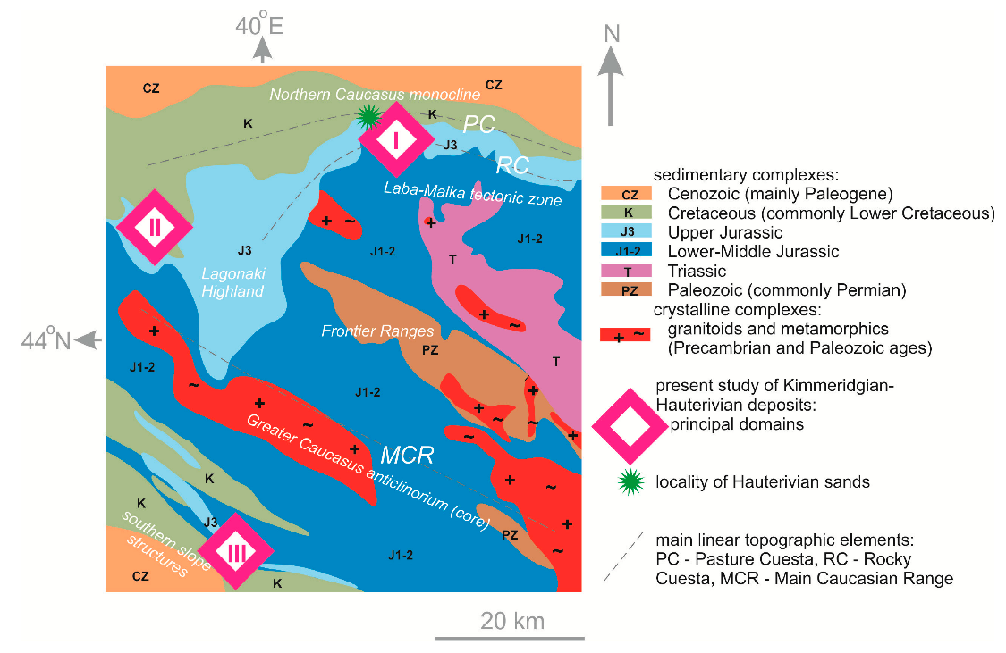
| Andreev [18] | Description of regional stratigraphy | Middle Jurassic–Cretaceous ** | III |
| Drushits and Mikhailova [7] | Stratigraphical, paleontological, and paleogeographical analyses | Early Cretaceous | I |
| Guo et al. [8] | Sedimentological and paleogeographical analyses | Late Jurassic *** | I, II, III |
| Egoyan [19] | Description of regional geological history | Cretaceous | I, II |
| Egoyan and Tkachuk [20] | Stratigraphical and paleogeographical analyses | Hauterivian | I |
| Goryacheva et al. [21] | Stratigraphical and palynological analyses | Tithonian | II |
| Korsakov et al. [15] | Description of local geology, including stratigraphy | Jurassic–Cretaceous ** | I |
| Luppov [22] | Stratigraphical, paleontological, and paleogeographical analyses | Early Cretaceous | I, II |
| Mikhailenko and Ruban [23] | Geoheritage inventory with geological descriptions | Late Jurassic–Early Cretaceous | I |
| Mordvilko [24] | Stratigraphical and paleogeographical analysis | Early Cretaceous | I |
| Rostovtsev et al. [25] | Stratigraphical reference book | Jurassic | I, II, III |
| Ruban et al. [26] | Geoheritage inventory with geological descriptions | Late Jurassic | I |
| Minerals | Samples * | |||||
|---|---|---|---|---|---|---|
| TF-1 | TF-2 | TF-3 | ||||
| Counts | Content, % | Counts | Content, % | Counts | Content, % | |
| Anatase | 12 | 5.36 | 29 | 18.35 | 44 | 9.59 |
| Rutile | 25 | 11.16 | 45 | 28.48 | 83 | 18.08 |
| Brookite | 4 | 1.79 | 4 | 2.53 | 2 | 0.44 |
| Zircon | 88 | 39.29 | 41 | 25.95 | 181 | 39.43 |
| Garnet ** | 10 | 4.46 | 14 | 8.86 | 37 | 8.06 |
| Chromite | 31 | 13.84 | 6 | 3.80 | 38 | 8.28 |
| Staurolite | 1 | 0.45 | 6 | 3.80 | 23 | 5.01 |
| Tourmaline ** | 9 | 4.02 | 10 | 6.33 | 6 | 1.31 |
| Siderite | 44 | 19.64 | 3 | 1.90 | 10 | 2.18 |
| Apatite ** | - | - | - | - | 11 | 2.40 |
| Monazite ** | - | - | - | - | 24 | 5.23 |
| TOTAL | 224 | 100.01 *** | 158 | 100.00 | 459 | 100.01 *** |
| Time Intervals | Traditional Scenario * | Hypothetic Scenario ** |
|---|---|---|
| Quaternary | Deformations, total uplift and erosion, exposure of Jurassic–Cenozoic and pre-Jurassic rocks | Deformations, total uplift and erosion, exposure of Jurassic–Cenozoic (where they accumulated) and pre-Jurassic rocks (in the core of the former denudated landmass), gravitational sliding of large slices of the Mesozoic–Cenozoic sedimentary complex |
| Second half of Ceonozoic | Accumulation of marine deposits around a denudated landmass (paleoisland?) | |
| Mid-Early Cretaceous–mid-Cenozoic | Widespread accumulation of marine deposits | |
| Tithonian–Hauterivian | Accumulation of marine deposits (widespread) and lagoonal and terrestrial deposits (local) | Deformations, uplift and erosion, exposure of Jurassic and pre-Jurassic rocks, accumulation of marine deposits around an eroded landmass (paleoisland?) |
| Callovian–Kimmeridgian | Carbonate platform development with partial transition to lagoons and sabkhas | |
| End-Bathonian | Deformation, total uplift and erosion, exposure of pre-Jurassic rocks | |
| Sinemurian–Bathonian | Accumulation of marine deposits | |
| Hettangian | Deformation, total uplift and erosion, exposure of pre-Jurassic rocks | |
Disclaimer/Publisher’s Note: The statements, opinions and data contained in all publications are solely those of the individual author(s) and contributor(s) and not of MDPI and/or the editor(s). MDPI and/or the editor(s) disclaim responsibility for any injury to people or property resulting from any ideas, methods, instructions or products referred to in the content. |
© 2025 by the authors. Licensee MDPI, Basel, Switzerland. This article is an open access article distributed under the terms and conditions of the Creative Commons Attribution (CC BY) license (https://creativecommons.org/licenses/by/4.0/).
Share and Cite
Ruban, D.A.; Zorina, S.O.; Nikashin, K.I.; Muzafarov, R.N. The Central Western Caucasus at the Jurassic–Cretaceous Transition: A Synthesis with a Case Study. J. Mar. Sci. Eng. 2025, 13, 1257. https://doi.org/10.3390/jmse13071257
Ruban DA, Zorina SO, Nikashin KI, Muzafarov RN. The Central Western Caucasus at the Jurassic–Cretaceous Transition: A Synthesis with a Case Study. Journal of Marine Science and Engineering. 2025; 13(7):1257. https://doi.org/10.3390/jmse13071257
Chicago/Turabian StyleRuban, Dmitry A., Svetlana O. Zorina, Konstantin I. Nikashin, and Rafael N. Muzafarov. 2025. "The Central Western Caucasus at the Jurassic–Cretaceous Transition: A Synthesis with a Case Study" Journal of Marine Science and Engineering 13, no. 7: 1257. https://doi.org/10.3390/jmse13071257
APA StyleRuban, D. A., Zorina, S. O., Nikashin, K. I., & Muzafarov, R. N. (2025). The Central Western Caucasus at the Jurassic–Cretaceous Transition: A Synthesis with a Case Study. Journal of Marine Science and Engineering, 13(7), 1257. https://doi.org/10.3390/jmse13071257