Article

Folding of Oceanic Crust Along the Davie Fracture Zone, Offshore Tanzania

1
College of Marine Science and Technology, Zhejiang Ocean University, Zhoushan 316022, China
2
Research Institute for Intelligent Earth Systems, Zhejiang Ocean University, Zhoushan 316022, China
3
Key Laboratory of Tectonics and Petroleum Resources (China University of Geosciences), Ministry of Education, Wuhan 430074, China
*
Authors to whom correspondence should be addressed.
J. Mar. Sci. Eng. 2025, 13(6), 1179; https://doi.org/10.3390/jmse13061179
Submission received: 13 May 2025 / Revised: 13 June 2025 / Accepted: 14 June 2025 / Published: 16 June 2025
(This article belongs to the Section Geological Oceanography)

Abstract

:
The Davie Fracture Zone (Davie FZ)—among the longest offshore transform systems in East Africa—mediated Madagascar’s southward displacement following Gondwana’s Early Jurassic breakup. This giant structure has a distinct topography and gravity field signals. However, it is buried by thick sediments in its northern segment offshore Tanzania, hindering understanding of the internal structures and their origin. In this study, we applied 2-D multichannel seismic to analyze the structural characteristics and evolution of the Davie FZ. The Davie FZ is located in the oceanic domain, which is bordered by the landwards-dipping overthrust fault at the continent–ocean boundary. Volcano sediments atop the basement with undulating Moho reflection below depict a typical oceanic domain. Distinct compressive deformation characterized by the crustal undulation of around 40 km wavelength forms folded oceanic crust, and Late Jurassic sediments onlap onto the crest of the folded basement. The Davie FZ is localized in a corridor with the thickened oceanic crust and is presented by positive flower structures with faulted uplifted basement and deepened Moho. The Davie FZ evolved from a proto-transform fault located in Gondwana before the spreading of the West Somali Basin. During the Late Jurassic, a kinematic change shifted the spreading direction from NW–SE to N–S, resulting in a strike-slip of the Davie FZ and contemporaneous transpressional deformation offshore Tanzania. The Davie FZ is an excellent case to understand the tectonic-magmatic process forming this transform margin.

1. Introduction

Two-end member scenarios of passive margins are divergent type controlled by normal fault extension and transform type governed by strike-slip extension, respectively [1,2,3,4]. All these margins record the tectonic-magmatic processes during the final continental breakup. By now, we have gained substantial insights into the characteristics of the continent–ocean transition at extensional margins [5,6]. As the oceanic lithosphere cools and thickens, it increases strength, and minor deformation is thought to occur in the oceanic domain away from plate boundaries [7]. However, passive continental margins are not generally tectonically passive. Instead, they underwent post-rift shortening, for example, in the NE Atlantic margin, resulting in compression of extremely thick sedimentary succession at the preexisting depocenters [8,9,10,11]. Similarly, several examples of intraplate compressive deformation in the oceanic crust have also been documented in the central Indian Ocean and the Equatorial Atlantic, resulting in the reactivation of fracture zones and generation of basement undulations with different wavelength scales [12,13,14,15,16,17]. The actual compressional deformation is speculated to be related to the rheological structure of the underlying lithosphere, regional stress field, or plume activity [11]. Therefore, the origins of compression structures in the basement are varied due to different geological settings.
Until the last decades, continental transform margins have been studied in the areas of Aghulas, Ivory Coast–Ghana, Exmouth plateau, and Demerara plateau, covered with deep industrial seismic data [18,19,20,21]. The Davie Fracture Zone (hereafter Davie FZ), one of the longest transform systems in offshore East Africa, accommodated the southward motion of Madagascar with respect to Africa, after the breakup of the Gondwana continent during the Early Jurassic [22,23]. Consequently, the oceanic crust in the West Somali and Mozambique Basins steadily grew. In most plate reconstructions, this transform fault is assumed to be located at the western edge of the West Somali Basin [22,24,25,26] (Figure 1).
Recently, seismic reflection profiles along the strike of the Davie FZ imaged a complex crustal fabric, and the likely oceanic crust in the extinct spreading center is present west of the Davie FZ [17,18,30,34]. Furthermore, the Davie FZ consists of transgressional and transtensional structures along different segments based on the basement structural map and cross-sections [18]. In the ocean domain offshore Kenya, the Davie FZ features a distinct thrust component that separates the typical oceanic crust to the east from the magmatic crust to the west, suggesting an oceanic transform in the spreading. Further south, in northern Mozambique, the Davie FZ bounds continental to oceanic crust. These findings conflict with the hypothesis that the Davie FZ is a single continent–ocean boundary. There seems to be a structural gap in the Davie FZ offshore Tanzania. Because transform faults are sub-vertical, the crustal thinning zones (such as “necking zones”) are narrow, and steep basement slopes are present adjacent to an oceanic domain [35]. There exists distinct crustal variability along the transform margin of East Africa [18,24]. The transform margin is a function of the pre-existing crustal architecture and syn- and post-transform geodynamic processes. Hence, the Davie FZ serves as an excellent case for examining crustal architectures and dynamic development of the East Africa transform passive margin.
Although previous studies have revealed a simple sheared direction of the Davie FZ by potential field data [28,34,36,37], as well as buckling and reverse faulting in the basement [17,18,29], the distribution of the Davie FZ and the crustal structures offshore Tanzania have not been characterized fully, yet the dynamic origin of the deformation is still controversial. In this paper, we present four profiles across the Davie FZ offshore Tanzania and the regional gravity data to analyze their structural characteristics and reconstruct their evolution processes.

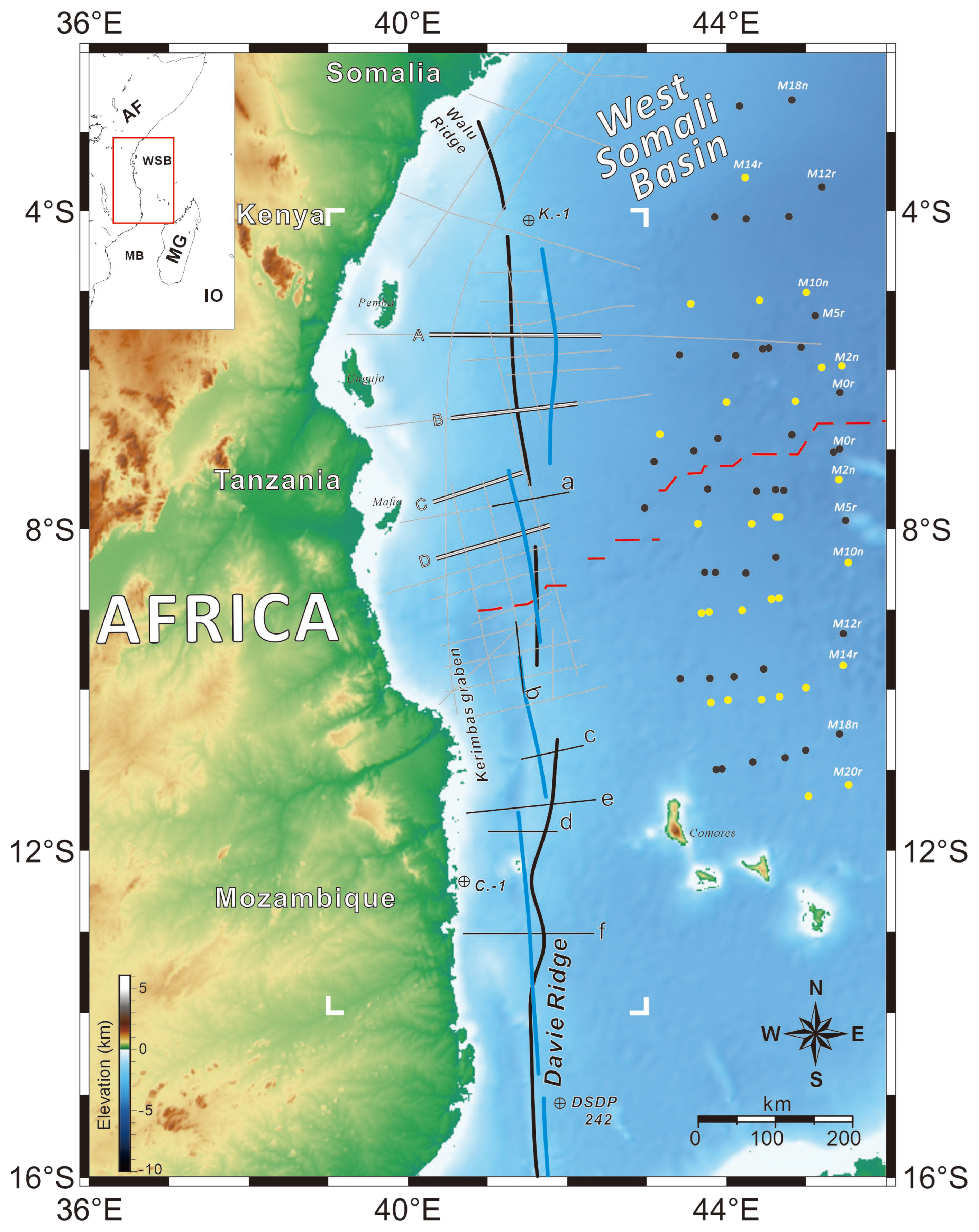
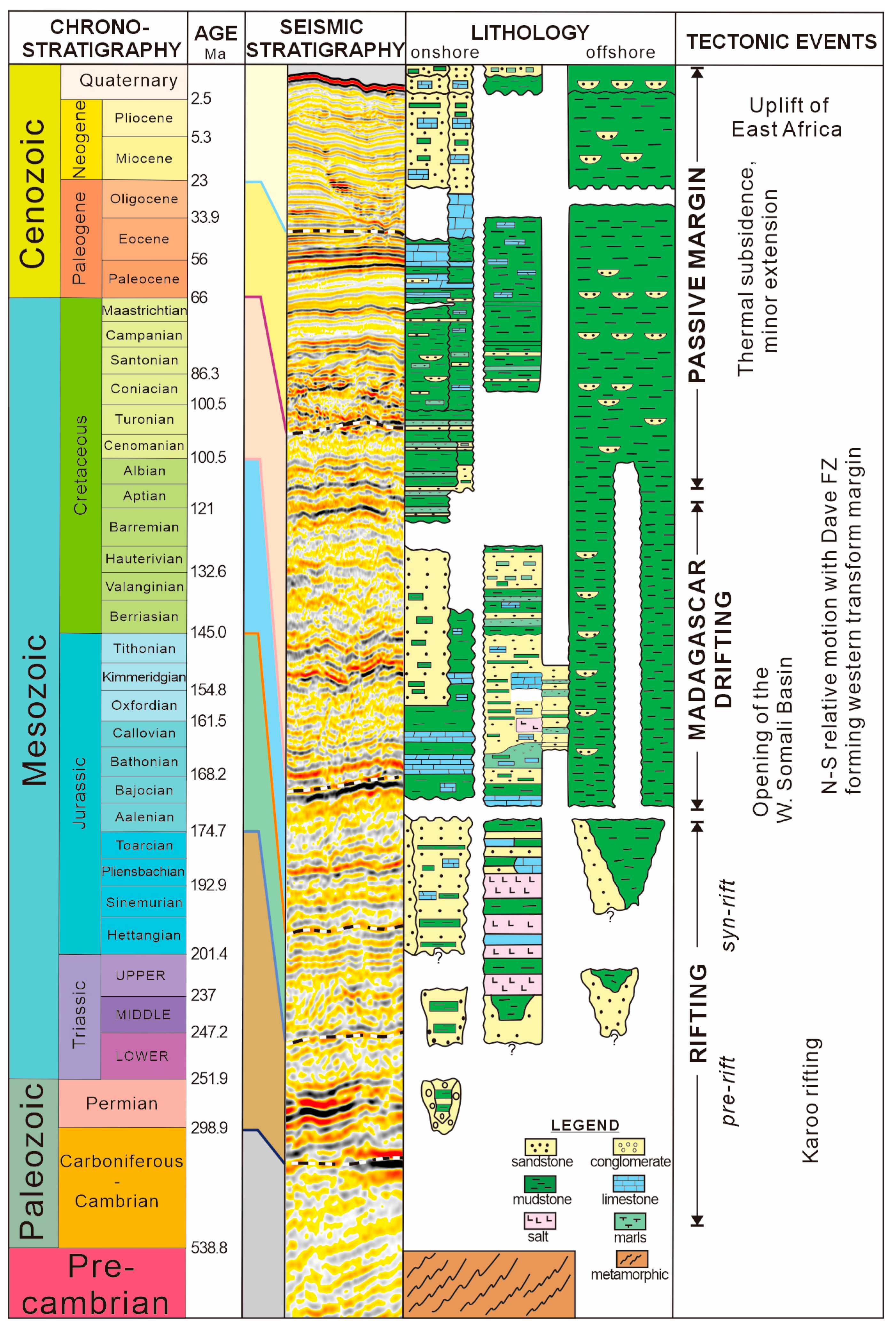
2. Geological Setting

Since the Neoproterozoic Pan-African orogeny, the evolution of East Africa is characterized by extensional events occurring from the Late Paleozoic to the Mesozoic eras, which superimpose upon the mobile accreted belts [26,38]. Therefore, structural inheritance is assumed to have been fundamental in the crustal breakup of offshore East Africa. The evolution of the Tanzania margin was preceded by three main development periods, namely, Karoo rifting, the breakup of Gondwana and the drift of Madagascar, and the formation of the East African passive margin (Figure 2). The first phase of rifting (Permian–Triassic), often referred to as the Karoo rifting, created half grabens bounded by NNW–SSE and NNE–SSW trending faults. The rifts were associated with volcanic rocks in southeast Tanzania and in southern Africa. Following the Karoo rifting event, the breakup of Gondwana in East Africa is marked by the inception of seafloor spreading between Africa and Madagascar in the Bajocian [39], which is older than recent magnetic anomalies (chron 24Bn, ca. 152 Ma) in the West Somali Basin [27]. Marine rocks were unconformably deposited over the break-up unconformity. The formation of the Tanzania passive margin occurred when Madagascar was completely separated from East Africa. Oceanic spreading created the West Somali Basin. The initial opening of the oceanic basin occurred in a northwest–southeast direction, followed by north–south spreading that governed the entire area around 156 Ma, resulting in the movement of Madagascar and Antarctica along the Davie FZ [25,40,41]. This new plate configuration lasted until 120 Ma when spreading between Africa and Madagascar ceased [28,42]. During the Late Cenozoic, there was a period of uplift, thermal doming, and erosion in East Africa, possibly related to the development of the modern East African rift systems (Figure 2).
The Davie FZ, also known as Davie Ridge, is clearly marked by a long linear contrast of positive and negative free-air anomalies between 9° S and 20° S [28,34]. South of 14° S, it is a distinctive bathymetric elevation rising ~1–2 km above the surrounding seafloor. In northern Mozambique and southern Tanzania, the Davie FZ represents a steep transform margin extending from 15° S to 10° S [29]. Recent data from wide-angle surveys indicate that the continental crust, with a thickness ranging from 10 km to 12 km, is situated along the Davie Ridge (14° S–16° S). Additionally, it is plausible that a high-velocity body underlies the extensively stretched continental crust [43]. Further north to 4° S, it seems to divide into two branches corresponding to the Seagap Fault and the Davie–Walu Fault as it approaches the Walu ridge, which is buried under unfaulted sediments [18]. Consequently, the Davie FZ is a multifaceted feature that exhibits diverse crustal and structural styles across its sections. Seismic profiles reveal extensional structures like Neogene rift-grabens in northern Mozambique. Also, compression along the west Davie Ridge forms a typical thrust wedge in the Mozambique Basin [44]. Sauter et al. found buckle folds along a 15 km–30 km wide corridor within the oceanic crust [17]. The interpretation of the Davie FZ is still debated due to its complexity and north–south variability. Although gravity and magnetic anomalies have been used to link the Walu Ridge to the Davie FZ, seismic reflection data lack clear evidence of the Davie FZ north of 9° S [22,29,34,36,42,43,45].

3. Data and Methods

We applied a total of 37 2-D reflection seismic profiles from the East Africa geophysical data set courtesy of CNOOC (Figure 1). This zero-phase multichannel data, displayed with variable density and SEG normal polarity (red peak represents increased acoustic impedance), has a 10 km long seismic streamer and an 18 s TWTT record length. The sample interval is 4 ms, and trace samples are 4501. The detailed acquisition such as air-gun array and data processing is not introduced in the text, and we finally interpreted it in the pre-stack time migration domain. The recorded time of seismic reflection data, when converted to depth, generally exceeds 25 km. Therefore, the data enables us to visualize sedimentary sequences above the basement, and in some areas, to identify the deep crustal reflectors. Most calibration wells we referred to are situated in the proximal zones of shallow water margins or even onshore oilfields. The stratigraphic framework derived from a deep water well (K.–1, Figure 1) has been utilized to constrain seismic facies down to the Hauterivian in the western West Somali Basin [31]. In the central section of the Davie FZ, near the Kerimbas basin, a well (C.–1, Figure 1) penetrating down to Barremian–Aptian is also used. However, since these two wells are situated at the upper and lower ends of the study area, it is necessary to seismically extend these sections further toward the central Davie FZ (5° S–9° S) and the oceanic domain. Ultimately, we obtained six seismic reflection horizons tied with different ages.
The seismic quality is superior for crustal deep imaging up to Moho, and even local intra-mantle reflections may also be identified. However, the specific interpretation of these reflections remains uncertain due to the absence of ocean bottom seismometer (OBS) data collection along the survey line. Typically, current seismic exploration techniques can delineate primary reflection boundaries, such as major faults, basement structures, and the Moho discontinuity, with relatively clear resolution. Based on a compilation of several geophysical attributes of the oceanic crust [46], we analyzed the crustal structure to identify if the basement beneath is continental, oceanic, or transitional. However, we need to exercise caution in areas affected by later rifts, like the Cenozoic grabens, and post-spreading magmatic additions. These features prominently impact the gravity data and obscure the true nature of crustal architectures. The gravity (surface free-air and Bouguer) dataset from the International Gravimetric Bureau (BGI) [47] has been applied to define key boundaries.

4. Results

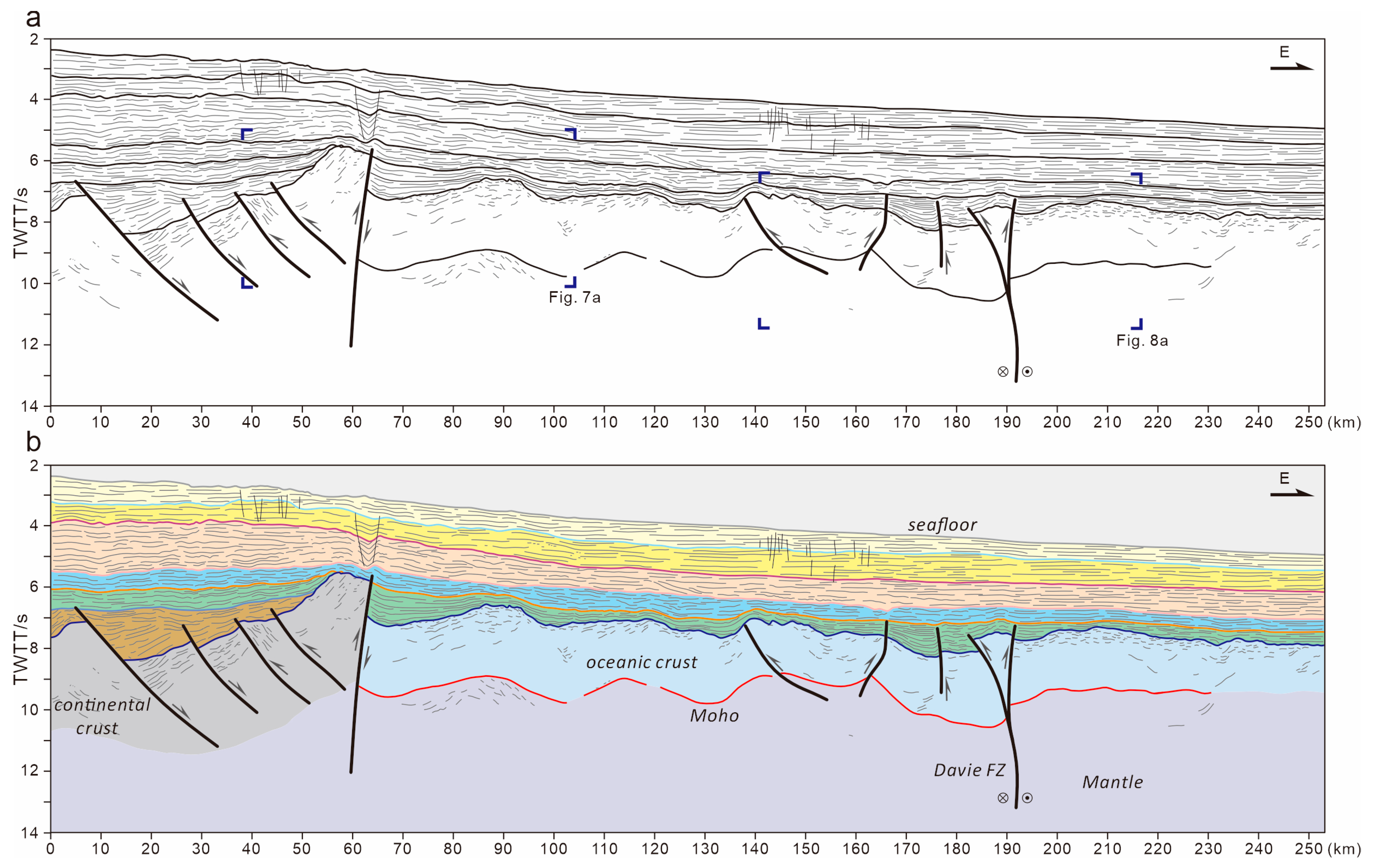
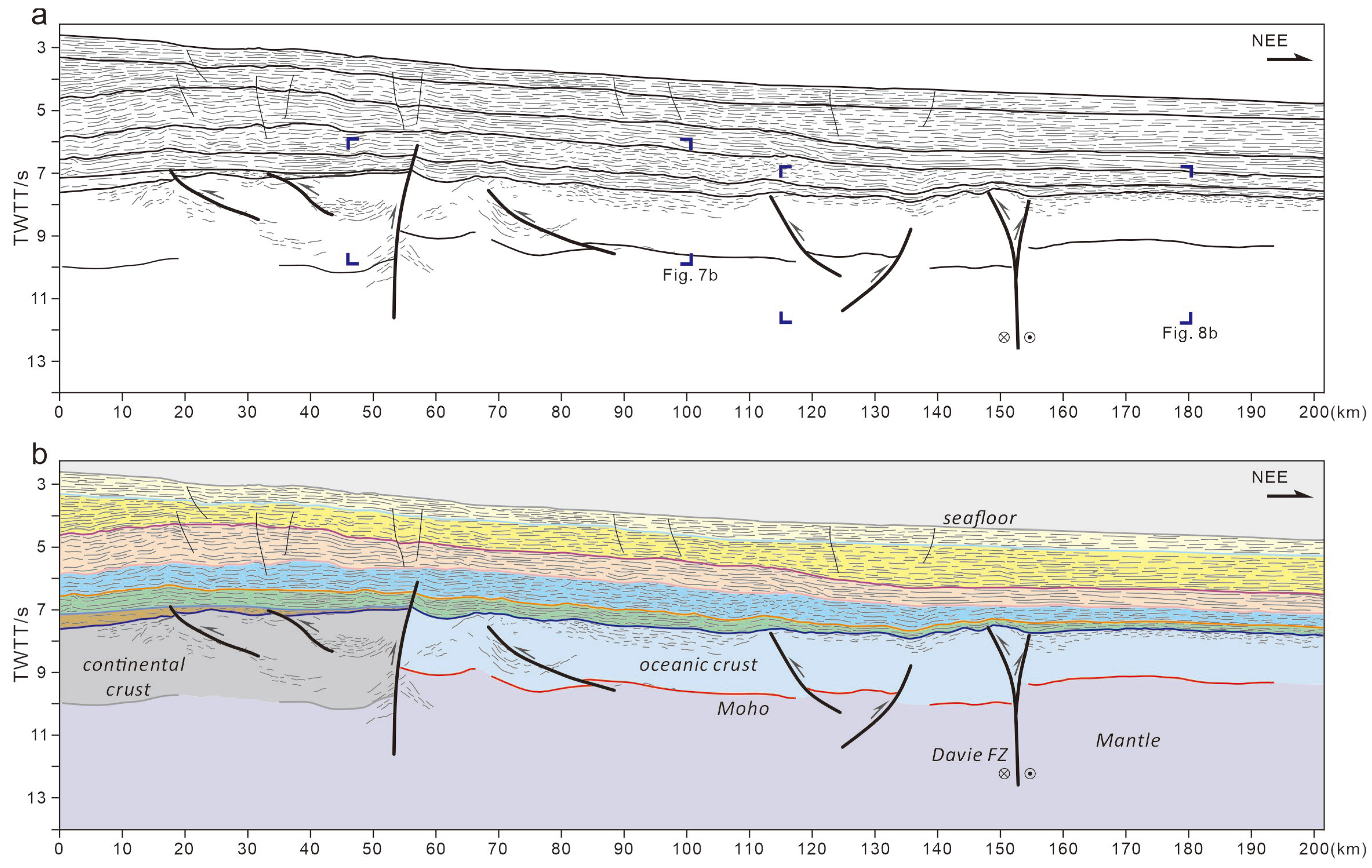
4.1. Crustal Domains

Two distinct structural zones were identified by stratigraphic architectures and deep reflectors (Figure 3, Figure 4, Figure 5 and Figure 6). The first is a continental domain, which is presented in the seismic lines along Pemba and Unguja islands (Figure 3 and Figure 4). The continental domain is typically characterized by rifted blocks underlain by a shallowing Moho surface towards the West Somali Basin. Assuming the P-wave velocity of the continental crust is 6.45 km/s [48], the crust is 9.7 km thick, consistent with that of a continental proximal part. Above the basement, the syn-rift sediments below the early Jurassic breakup unconformity are characterized by middle-high frequency reflectors with wedge-shaped geometries in the central Tanzania margin (Figure 3 and Figure 7a). It is bounded by oceanwards dipping normal faults and onlaps onto a basement high at around 60 km (Figure 3). The termination of the continental domains in profile A and B is located at the west side of a steep thrust fault (60 km in Figure 3 and 53 km in Figure 4). However, no continental domain is present in Figure 5 and Figure 6 east of the Mafia island, indicating a westwards concave continent–ocean boundary in this region.
In the West Somali Basin, the top basement is characterized by smooth and sub-horizontal reflectors representing the oceanic domain. Middle to Late Jurassic sediments above the basement agree with the breakup age deduced by marine magnetic anomalies in the West Somali Basin. Below the oceanic crust, a fair continuous reflection at a depth of 9 s~10 s (TWTT) is ~2.1 s below the top basement (Figure 3), and it is generally identified as Moho at this level. In this area, the oceanic crust typically reaches a normal thickness of about 6 km, assuming an average velocity of 6 km/s in the oceanic crust. This signifies strong magmatic accretion with minimal tectonic extension. In the upper section of the oceanic crust, a group of strong reflectors extends oceanward for up to 150 km, analogous to the volcano-sedimentary sequence delineated by Sauter et al. [17]. This layer is distinct from the overlying sediments, as the sequence is typically characterized by its strong reflectivity at the top basement. However, these distinct reflections are not as clearly defined in areas where the top basement is relatively smooth (Figure 5 and Figure 7c). We interpreted that this sequence results from intermittent volcanic activity during seafloor spreading, forming interlayered basalts and sediment like oceanic layer 2.

4.2. Compression Deformation in the Oceanic Domain

Profile A extends from the south of Pemba island eastwards to the West Somali Basin (Figure 3). The top basement in the oceanic domain is severely bent from the continent–ocean boundary (around 60 km) to nearly the eastern part (around 230 km), forming several ridge–trough–type structures. The Moho reflection below them has a fairly consistent variation with the basement undulation. The oceanic crust forms a buckle fold with a wavelength of around 40 km. For example, the oceanic crust at 60 km–100 km thickens from 2.16 s TWTT at the west limb to 2.34 s TWTT at the axis of anticline (Figure 7a). West of this buckle fold, the uplift and rotation of the continental basement led to the erosion of post-rifting sediments, as well as crustal thickening to some extent, supporting a reverse fault that juxtaposed the initial oceanic crust. The overlying Jurassic sedimentary packages in the footwall have a maximum thickness of 1.1 s TWTT near the fault plane, responding to the compressional tectonics. In the west part of the profile, the folded oceanic crust is further dissected into several fault blocks (Figure 8a). The antithetic reverse faults, cutting across the Moho and soling down into the mantle, result in basement uplift at 140 km–160 km. A prominent depocenter accompanied by thickened post-rifting sediments is located at 170 km–195 km, where the Moho reaches around 10.5 s TWTT, deeper than that on both sides. The basement above the Moho is also uplifted to 7.5 s TWTT by a group of antithetic faults. The crust thickness increases to 2.98 s TWTT around 190 km, thicker than the surrounding oceanic crust, no more than 2 s TWTT thick (Figure 8a).
In the southeast of Unguja island, the oceanic crust 100 km to the south of profile A has similar structures (Figure 4). The top basement of the oceanic crust gradually deepens from around 7.1 s TWTT in the west to 7.8 s TWTT in the east, showing a short wavelength buckle fold in the oceanic crust. At the continent–ocean boundary, the deepened top basement and thickened post-rifting sediments indicate a west-dipping reverse fault with a steep angle. A nearly vertical zone with chaotic reflection probably represents a hydrothermal vent along the fault. On the east side of the boundary, two groups of high-amplitude reflectors with opposite dip directions construct a triangle zone in the upper part of the oceanic crust (Figure 7b). The upper oceanic crust is characterized by high-amplitude and middle continuous reflectors, representing volcanic-clastic sediments. The Moho reflection is located at around 9.5 s TWTT in depth and is offset by a west-dipping reverse fault with a low angle at around 70 km–83 km (Figure 4 and Figure 7b). The Moho reflection at 115 km–154 km has an obvious offset and is uplifted by two pairs of antithetic reverse faults (Figure 8b). In the middle part of the enlarged image, the Moho is located at around 10 s deeper than that on both sides. A thickened oceanic crust of 2.53 s TWTT thickness indicates syn-compressional deformation, consistent with thinned sediments above the rough top basement.
A westward propagation of seafloor spreading is evidenced by total oceanic crust in profiles C and D, located east of the Mafia island. In profile C (Figure 5), the smooth top basement and Moho reflection define a fairly uniform oceanic crust with a thickness of 2 s TWTT at 60 km (Figure 7c). The top basement has an undulation with a wavelength of around 30 km. However, distinct compressive deformation of the top basement is identified by buckle folds at 65 km–135 km in the east part of the profile, consistent with a gradually uplifted basement towards the east (Figure 5). This deformation results in several depocenters by thickened Middle–Late Jurassic sediments accumulated in the low relief folds (e.g., 75 km–87 km, 95 km–107 km in Figure 5). The intra-crustal structure characterized by a group of eastward dipping reflectors is interpreted as thrust faults. A more undulated top basement is shown in most of profile D, indicating a compressive force nearly perpendicular to the spreading direction. Both the top basement and the base of the oceanic crust show undulations with a similar wavelength, forming an unequal thickness of the oceanic crust. Syn-compressive sediments sparsely accumulate in the troughs above the top basement. High-amplitude reflectors of volcanic sediments are located in the upper section of the oceanic crust. A group of dipping reflectors with middle-amplitude (35 km–53 km) soles down to the Moho and is truncated upward by volcanic sediments. These intra-crustal reflections are also interpreted as thrust faults (Figure 6 and Figure 7d).

4.3. Trace of the Davie FZ

The Davie FZ is characterized by an oceanic transform fracture that has distinct crustal structures. Buckle folding and thrusting accommodating compressional deformation result in crustal thickening in some places, particularly around the Davie FZ (Figure 8a–d). In profile A, the Davie FZ characterized by a group of steep faults marking a crustal discontinuity acting as the boundary between bent oceanic crust and normal oceanic crust at around 190 km (Figure 3 and Figure 8a). The abrupt variation of the crustal thickness across the Davie FZ indicates a compressive force field, resulting in a downward curved Moho surface at the left side of the main fault. Syn-compressive sediments with a large offset above the basement show a pop-up structure. These reverse faults steepening downward into the mantle comprise a positive flower structure, suggesting strike-slip deformation during seafloor spreading. In contrast with profile A, the Davie FZ occupies a 20 km wide zone of basement uplift in profile B (Figure 4, 140 km–160 km).
An obviously thickened crust floored by a deepened Moho surface is bounded by an undeformed oceanic crust across the fracture zone (Figure 8b). The syn-compressive sediments are also thickened on both sides of the uplifted basement. The Davie FZ in profile C is located in a local high relief at 110 km–125 km, where the sediments onlap towards the crest until the end of the Jurassic (Figure 8c). The Moho surface below the fracture zone bends upward, consistent with the basement uplift. The internal reflection in the crust forms a positive flower structure with a series of opposite dipping reflectors. Similar to profile C, the Davie FZ is presented by a positive terrain in the basement at around 116 km–132 km (Figure 6). The Moho surface deepens below the uplifted basement and forms a thickened oceanic crust adjacent to regular oceanic crust in the east (Figure 8d). The steep faults and variable throws of the Moho and top basement indicate a strike-slip nature, evidenced by their similar positive flower geometry.

5. Discussion

5.1. Basement Architecture Along the Davie FZ

Along the Tanzania margin, seismic reflection data reveal two distinct deformed zones, with the first one a proximal zone characterized by buckle folds of oceanic crust, and the second one the steep strike-slip faults with positive flower structures along the Davie FZ (Figure 3, Figure 4, Figure 5 and Figure 6). On the landward side of the West Somali Basin, the top basement and the Moho show folds with a roughly 20 km wavelength. This deformation is probably associated with significant thrust faults in the continent–ocean boundary, such as the Seagap Fault; however, it is out of range in profiles C and D. These thrusts have steep dips and extend downward into the basement, reaching even the Moho. In the upper crust, the volcanic sediments characterized by mound-shaped reflectors atop the basement are nearly parallel to the folded top oceanic crust, indicating that the volcanic sequence was folded simultaneously with the seafloor spreading [17]. An average thickness of about 6 km supports the oceanic nature of the crust in this proximal area [29].
The top basement in the Davie FZ is deformed to a convex-up geometry, and the Moho below is almost subparallel to the top basement. Highly dipping bright reflectors with jagged shape in the crust and faulted top basement probably resulted from the transpressional activity of the Davie FZ (Figure 9a) [29]. In the south, the basement below the Davie FZ is characterized by an N–S gravity high (Figure 10), which is named the Davie Ridge. Cutting across the Davie Ridge along an N–S direction profile (Figure 9b), a thickened crust with the shallowest part of the volcanic edifice indicates oceanic origin like in the volcano center [17]. The faulted top basement probably resulted from Cenozoic rifting, which is the seaward extension of the East African Rift System. Similarly, the Davie Ridge is defined by a bulged and extensively deformed top basement, with chaotic reflectors beneath it, evidencing substantial magmatic activity in an oceanic setting (Figure 9c) [29]. However, along the Kerimbas basin, the Davie Ridge has a distinct seabed relief with fault scarps, and the top basement is deformed to an anticline shape [31] (Figure 9d). The thick sediments infilling the trough above the top basement attest syn-transform faulting during the oceanic spreading. A hybrid flower structure exists with an anticline shape characterized by fault-bend folds and several normal faults merging downward into a single strand, implying a synchronous presence of compressional and extensional deformation along the Davie FZ [49].

5.2. Boundary of Oceanic Deformation

Previous research revealed a series of deformation corridors trending nearly N–S about 30 km–50 km wide from 4° S–10° S, 41° E [17]. In the east of the Pemba and Unguja islands, they are focused on two branches with N–S and NNW–SSE trends. These two branches divide the oceanic domain into two deformed zones. One is situated along the continent–ocean boundary, characterized by an anomalous high basement relief that trends north–south along the Seagap Fault, which is likely associated with oblique-slip tectonics. Based on Early Jurassic sediments in the continental graben, the deformed zone is inferred to be Middle–Late Jurassic age. This is consistent with Middle–Late Jurassic packages onlapping the folded top basement of the oceanic crust (Figure 3). The second one is localized along the Davie FZ, with the thickened oceanic crust deformed by transpressional force. The hinge points of the buckle folds along the NEE–SWW trending profiles reveal that these folds are aligned with the strike of gravity lineations (Figure 10a).
In the free-air gravity map, this domain is parallel to an area with a negative minimum value, corresponding to the relatively low basement relief in profiles A and B (Figure 3 and Figure 4). The gravity corridors border the Davie Ridge on both flanks around the inferred extinct ridge axis in the south. In the Bouguer gravity anomaly, the right boundary of the deformation is distinct and limited to a N–S elongated gravity lineation around 42° E (Figure 10b). The seawards increase in the gravity values indicates a sharp Moho uplift at the right boundary, and this is consistent with the change of the Moho depth in seismic reflection (Figure 3, Figure 4, Figure 5 and Figure 6). In gravity modeling along profile a (Figure 9a), it is assumed that additional volcanic materials below the oceanic crust can better match the magmatically thickened crust of the Davie FZ [29]. However, the largest thickness is distributed along the Davie FZ (Figure 8), where the deformed oceanic crust mostly exceeds 2 s TWTT and is nearly twice that of the normal oceanic crust, probably indicating syn-compressive deformation in the oceanization process. Due to transform faults, we propose that the inherited oceanic crust likely played a significant role in shaping the deformation of the oceanic crust.

5.3. Regional Tectonic Reconstruction

In an initial fit of Madagascar with respect to Africa, two pairs of conjugate margins are separated by the Aswa–Tombo fault system [25,50], which is replaced later by the Davie FZ (Figure 11a). On the left of the Tombo fault, an oblique rifting represented by a pull-apart margin is composed of the Tanga–Mombasa–Morondava system. The extension direction follows the strike of the Tombo fault. The rifting between East and West Gondwana coincides with the eruption of the Karoo Large Igneous Province in Mozambique [39,40]. The breakup of Gondwana was preceded by seafloor spreading in western Somalia at the end of the Early Jurassic (Figure 11b). The Bajocian–Bathonian carbonates are identifiable as the marine intrusion. The Early Bajocian unconformity is interpreted as the breakup unconformity [39]. From magnetic anomalies with a confident date [36,42], the oldest magnetic anomaly M41n in the West Somali Basin suggests a late Toarcian–Aalenian age for the breakup and seafloor spreading commenced around 170 Ma, which is consistent with the stratigraphic frame defined in this study (Figure 2).
Around 150 Ma, a regional kinematics change from NW–SE to N–S affected all of eastern Africa [26,27,51,52]. An onset phase of SSE plate separation translated Madagascar along the Tanzania coastal basins, which are likely connected by Davie transform faults to avoid plate overlapping. This significant kinematic reorganization may be related to the beginning of the South Atlantic rifting and/or the formation of the Indian Ocean between India and Antarctica [53,54]. The NW–SE trending proto-transform system transitions into the major N–S Davie transform system, which responds to this plate adjustment. This novel plate motion proved incompatible with the early SSE trending fracture zones located offshore Tanzania, resulting in transpressional deformation within the basement and the thrusting of oceanic crust along pre-existing fracture zones (Figure 11c,d). The analogue models clearly describe how normal boundary faults of pull-apart basins are inverted, including the fault’s polarity and dip direction in accommodation zones [55]. Numerical modelling showed that initial discrete spreading centers nucleate within the propagating rift, regardless of structural inheritance. When additional thermal perturbation occurs, a series of proto-transforms make disorganized spreading centers into an echelon array and finally form an organized ridge-transform geometry [29,56]. A series of spreading reorganizations with new magmatic accretion turn the initial oblique proto-transforms into one perpendicular to the spreading centers. This phenomenon can also be identified by the interpreted flow line geometries in the West Somali Basin [26,51].
Unlike the neighboring extensional margin, the transform margin remains heated in the post-breakup period. When the incipient oceanic ridge moves along the transform margin, lateral thermal exchange between the cold continental margin and the hot spreading center occurs through conduction [57]. The offshore Tanzania transform corridor is probably episodically heated to obtain additional magma when the newly formed spreading center passes along the transform margin. This spreading reorientation not only induced crustal shortening and overthrusting but also enhanced the melting between the fracture zones. A higher magma budget produced a thicker crust between the continent–ocean boundary and the Davie Ridge. As spreading gradually diminished, the magma budget at the spreading ridge decreased to produce a thinned oceanic crust. Large tilted fault blocks accompanied by syn-tectonic volcano-sedimentary sequences are distributed along the extinct ridge [17]. The southward migration of Madagascar, a fragment within Eastern Gondwana, resulted in its intersection with the Western Gondwana continent and gave rise to the collision of south Madagascar with northeast Mozambique. Metamorphic arkosic sediments along the Davie FZ support collisional settings [58]. The Davie Ridge, an inverted and thrust sequence in the Jurassic, likely resulted from this plate collision along the eastern edge of the Angoche Basin and may therefore represent the continent–ocean boundary in this area [44].

6. Conclusions

In this study, we applied a dataset of 2-D multichannel seismic combined with potential field and published data in order to analyze the structural characteristics and evolution of the Davie FZ. Several key points are as follows:
(1)
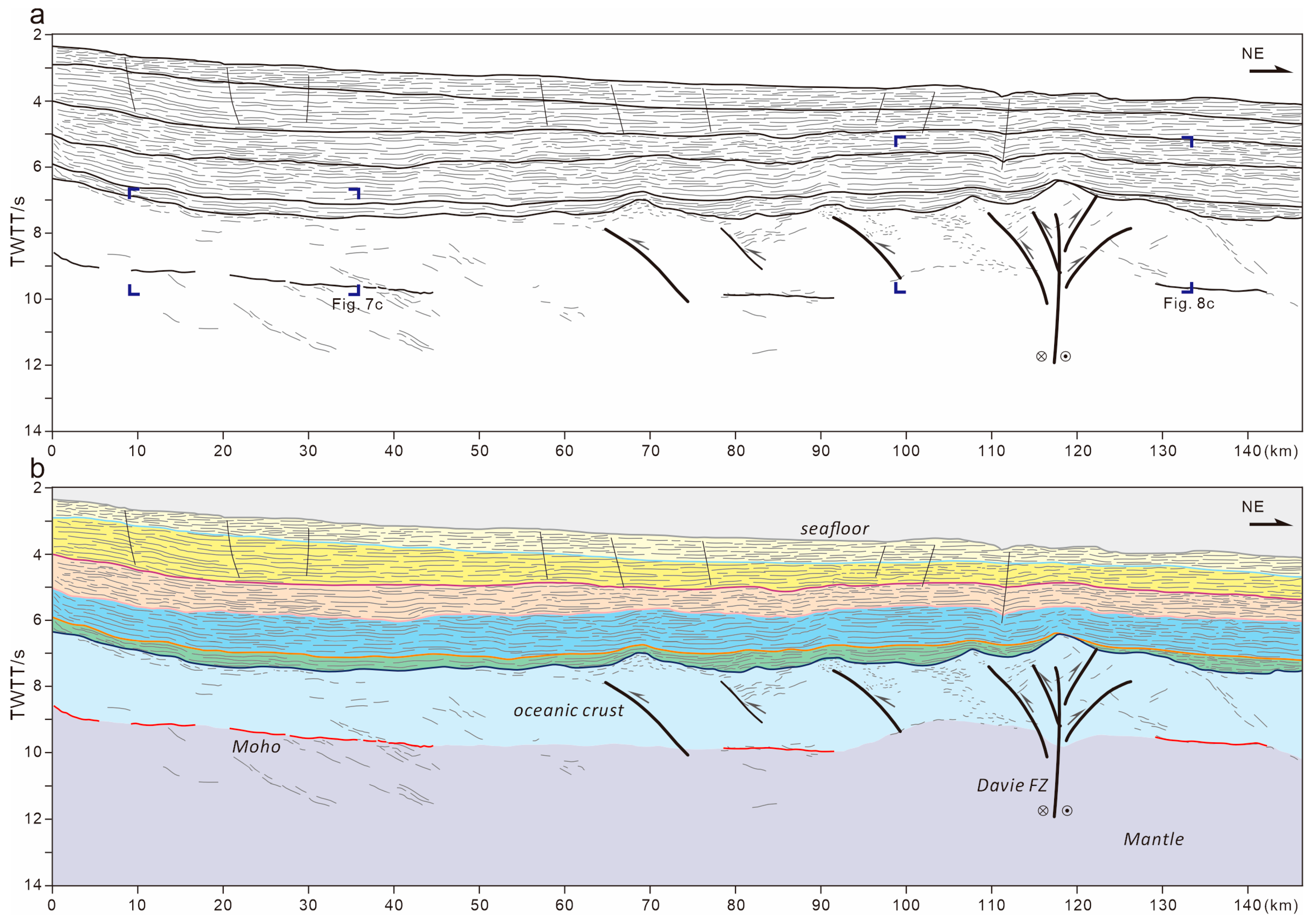
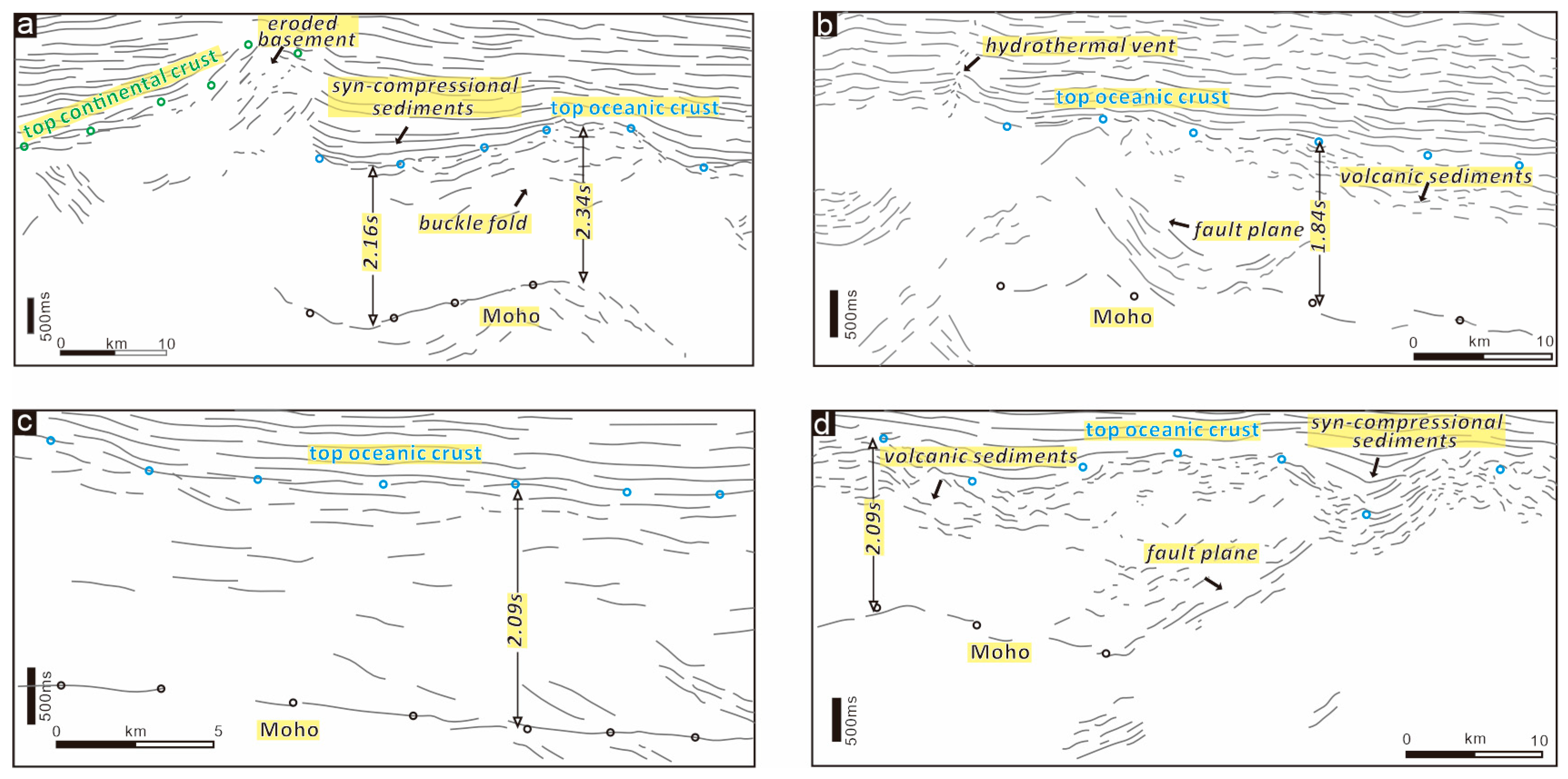
Stratigraphic architectures defined by several seismic horizons above the basement indicate a passive margin offshore Tanzania. The continental domain characterized by extended crust and seaward uplifted Moho is bordered by a landward dipping overthrust fault at the continent–ocean boundary. Seaward, a typical oceanic domain consists of volcanic sediments atop the basement and undulating Moho reflection in the deep.
(2)
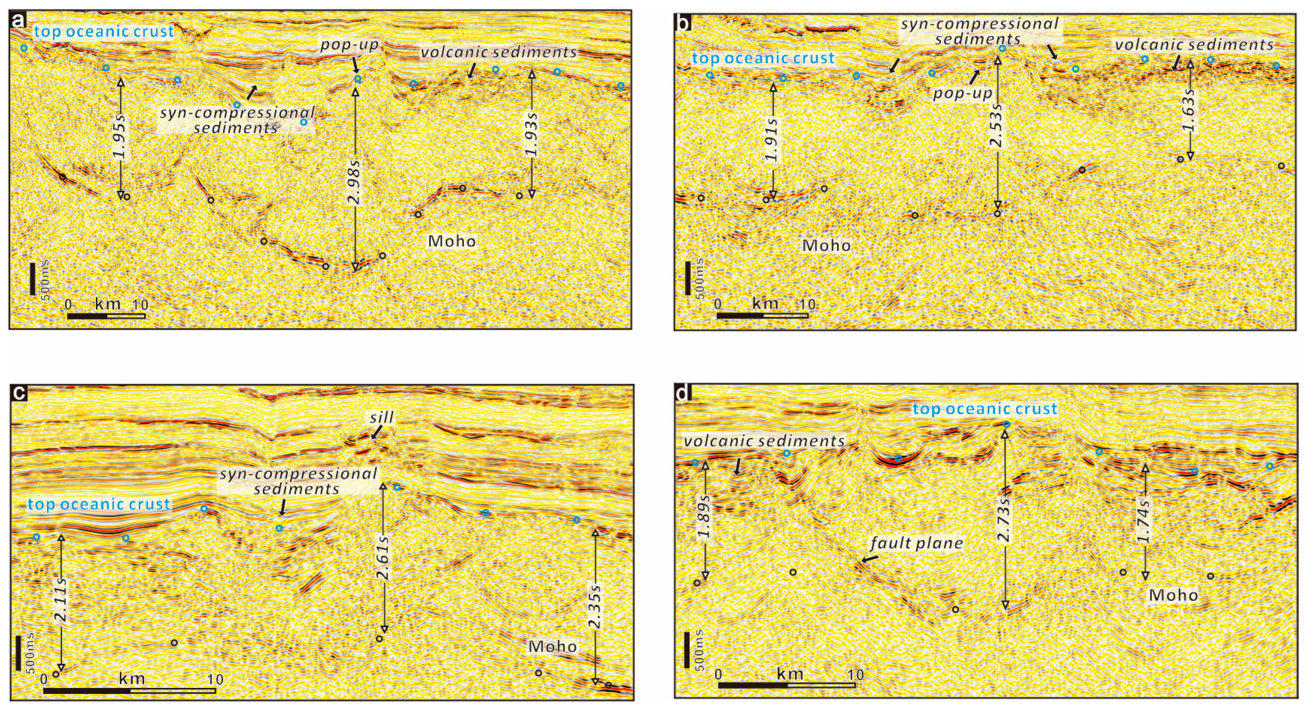
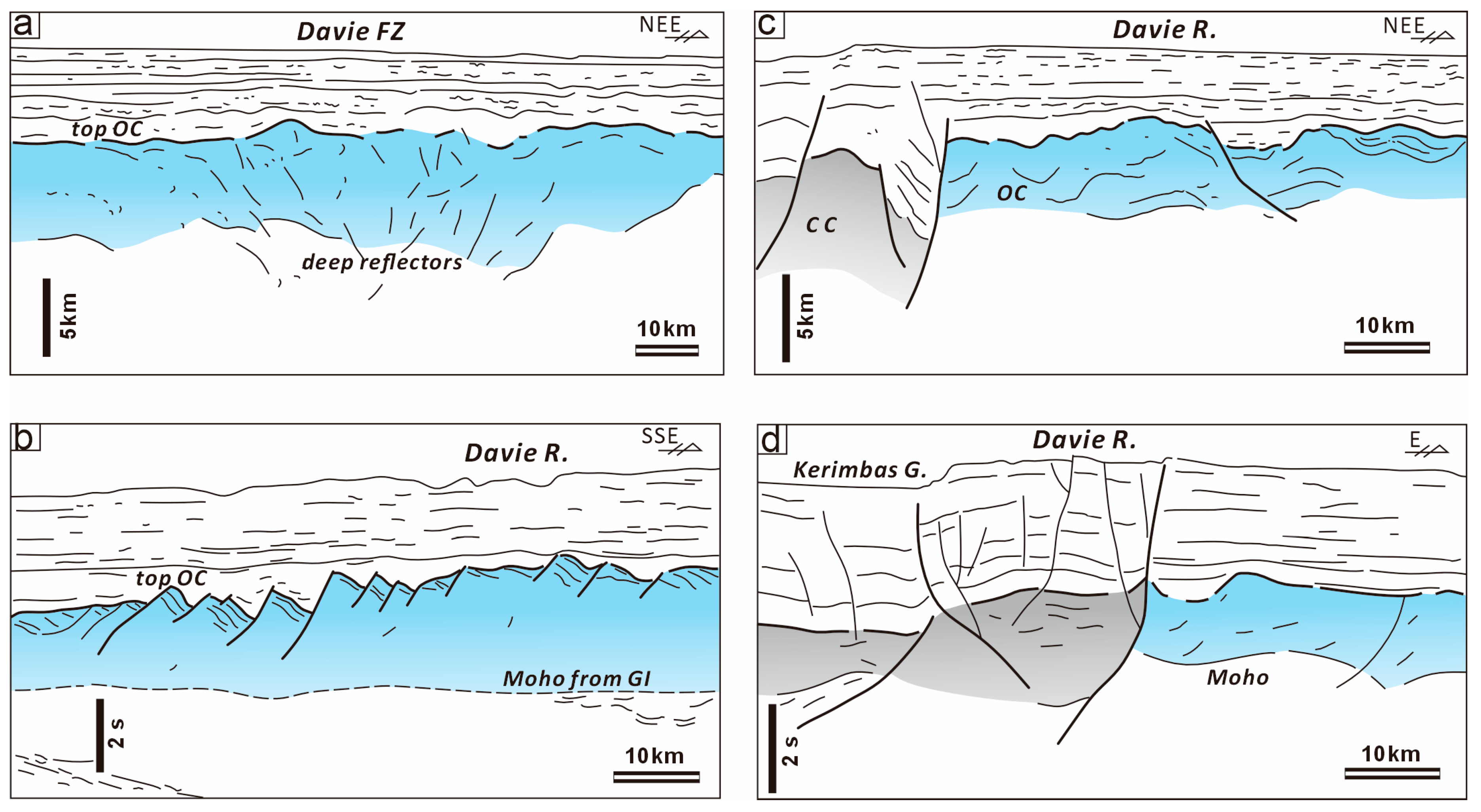
Distinct compressive deformation characterized by crustal undulation of around 40 km wavelength occurs in the ocean domain. The thickened oceanic crust forms typical folds accompanied by thrust faults in the basement. The Davie FZ, characterized by positive flower structures with uplifted basement and deepened Moho, suggest strike-slip activity evidenced by Late Jurassic sediments onlapping onto the fold crest.
(3)
The Davie FZ evolved from a proto-transform fault located in Gondwana before the spreading of the West Somali Basin. During the Late Jurassic, a kinematics change shifted the spreading direction from NW–SE to N–S, resulting in a contemporaneous transpressional deformation in offshore Tanzania.

Author Contributions

Conceptualization, X.P.; Validation, Y.Z. and L.W.; Formal analysis, Z.L.; Investigation, Y.Z., L.W. and Z.L.; Resources, X.P. and Z.L.; Data curation, Y.Z., L.W. and Z.L.; Writing—review & editing, X.P.; Project administration, X.P.; Funding acquisition, X.P. All authors have read and agreed to the published version of the manuscript.

Funding

This study was supported by the National Natural Science Foundation of China (No. 42206049).

Data Availability Statement

The original contributions presented in this study are included in the article. Further inquiries can be directed to the corresponding author.

Acknowledgments

The authors are grateful to CNOOC for providing the research data. Many thanks to the editors, two anonymous reviewers, and S. Kovachev in the P.P. Shirshov Institute of Oceanology of RAS for constructive suggestions.

Conflicts of Interest

The authors declare no conflict of interest.

References

  1. Bird, D. Shear margins: Continent-ocean transform and fracture zone boundaries. Lead. Edge 2001, 20, 150–159. [Google Scholar] [CrossRef]
  2. Lavier, L.L.; Manatschal, G. A mechanism to thin the continental lithosphere at magma-poor margins. Nature 2006, 440, 324–328. [Google Scholar] [CrossRef] [PubMed]
  3. Geoffroy, L. Volcanic passive margins. Comptes Rendus Géoscience 2005, 337, 1395–1408. [Google Scholar] [CrossRef]
  4. Lundin, E.R.; Doré, A.G.; Naliboff, J.; van Wijk, J. Utilization of continental transforms in break-up: Observations, models, and a potential link to magmatism. Geol. Soc. Lond. Spec. Publ. 2023, 524, 121–145. [Google Scholar] [CrossRef]
  5. Peron-Pinvidic, G. (Ed.) Continental Rifted Margins 1: Definition and Methodology; ISTE Ltd./John Wiley and Sons Inc: Hoboken, NJ, USA, 2022; ISBN 9781789450613. [Google Scholar]
  6. Peng, X.; Li, C.-F. Along-strike break-up variations of the continent–ocean transition zone in the northern South China Sea. J. Geol. Soc. 2024, 181, jgs2023-134. [Google Scholar] [CrossRef]
  7. McAdoo, D.C.; Sandwell, D.T. Folding of oceanic lithosphere. J. Geophys. Res. 1985, 90, 8563–8569. [Google Scholar] [CrossRef]
  8. Doré, A.G.; Lundin, E.R.; Fichler, C.; Olesen, O. Patterns of basement structure and reactivation along the NE Atlantic margin. J. Geol. Soc. 1997, 154, 85–92. [Google Scholar] [CrossRef]
  9. Doré, A.G.; Lundin, E.R. Cenozoic compressional structures on the NE Atlantic margin nature, origin and potential significance for hydrocarbon exploration. Pet. Geosci. 1996, 2, 299–311. [Google Scholar] [CrossRef]
  10. Paton, D. Post-Rift Deformation of the North East and South Atlantic Margins: Are “Passive Margins” Really Passive? In Tectonics of Sedimentary Basins: Recent Advances; Busby, C., Pérez Azor, A., Eds.; Wiley-Blackwell: Hoboken, NJ, USA, 2012; pp. 249–269. ISBN 9781444347166. [Google Scholar]
  11. Cloetingh, S.; Beekman, F.; Ziegler, P.A.; van Wees, J.-D.; Sokoutis, D. Post-rift compressional reactivation potential of passive margins and extensional basins. Geol. Soc. Lond. Spec. Publ. 2008, 306, 27–70. [Google Scholar] [CrossRef]
  12. Bull, J.M.; Scrutton, R.A. Fault reactivation in the central Indian Ocean and the rheology of oceanic lithosphere. Nature 1990, 344, 855–858. [Google Scholar] [CrossRef]
  13. Bull, J.M.; Scrutton, R.A. Seismic reflection images of intraplate deformation, central Indian Ocean, and their tectonic significance. J. Geol. Soc. 1992, 149, 955–966. [Google Scholar] [CrossRef]
  14. Weissel, J.K.; Anderson, R.N.; Geller, C.A. Deformation of the Indo–Australian plate. Nature 1980, 287, 284–291. [Google Scholar] [CrossRef]
  15. Briggs, S.E.; Davies, R.J.; Cartwright, J.; Morgan, R. Thrusting in oceanic crust during continental drift offshore Niger Delta, equatorial Africa. Tectonics 2009, 28, TC1004. [Google Scholar] [CrossRef]
  16. Lawrence, S.R.; Beach, A.; Jackson, O.; Jackson, A. Deformation of oceanic crust in the eastern Gulf of Guinea: Role in the evolution of the Cameroon Volcanic Line and influence on the petroleum endowment of the Douala-Rio Muni Basin. Geol. Soc. Lond. Spec. Publ. 2017, 438, 7–26. [Google Scholar] [CrossRef]
  17. Sauter, D.; Ringenbach, J.C.; Cannat, M.; Maurin, T.; Manatschal, G.; McDermott, K.G. Intraplate Deformation of Oceanic Crust in the West Somali Basin: Insights From Long-offset Reflection Seismic Data. Tectonics 2018, 37, 588–603. [Google Scholar] [CrossRef]
  18. Roche, V.; Ringenbach, J.-C. The Davie Fracture Zone: A recorder of continents drifts and kinematic changes. Tectonophysics 2022, 823, 229188. [Google Scholar] [CrossRef]
  19. Basile, C.; Loncke, L.; Roest, W.R.; Graindorge, D.; Klingelhoefer, F.; Museur, T.; Heuret, A.; Lesourd-Laux, T.; Vetel, W. Initiation of transform continental margins: The Cretaceous margins of the Demerara plateau. Geol. Soc. Lond. Spec. Publ. 2023, 524, 327–337. [Google Scholar] [CrossRef]
  20. Loncke, L.; de Lépinay, M.M.; Basile, C.; Maillard, A.; Roest, W.R.; de Clarens, P.; Patriat, M.; Gaullier, V.; Klingelhoefer, F.; Graindorge, D.; et al. Compared structure and evolution of the conjugate Demerara and Guinea transform marginal plateaus. Tectonophysics 2022, 822, 229112. [Google Scholar] [CrossRef]
  21. Graindorge, D.; Museur, T.; Klingelhoefer, F.; Roest, W.R.; Basile, C.; Loncke, L.; Sapin, F.; Heuret, A.; Perrot, J.; Marcaillou, B.; et al. Deep structure of the Demerara Plateau and its two-fold tectonic evolution: From a volcanic margin to a transform marginal plateau, insights from the Conjugate Guinea Plateau. Geol. Soc. Lond. Spec. Publ. 2023, 524, 339–366. [Google Scholar] [CrossRef]
  22. Scrutton, R.A. Davie fracture zone and the movement of Madagascar. Earth Planet. Sci. Lett. 1978, 39, 84–88. [Google Scholar] [CrossRef]
  23. Coffin, M.F.; Rabinowitz, P.D. Reconstruction of Madagascar and Africa: Evidence from the Davie Fracture Zone and Western Somali Basin. J. Geophys. Res. 1987, 92, 9385. [Google Scholar] [CrossRef]
  24. Vormann, M.; Jokat, W. Crustal variability along the rifted/sheared East African margin: A review. Geo-Mar. Lett. 2021, 41, 19. [Google Scholar] [CrossRef]
  25. Thompson, J.O.; Moulin, M.; Aslanian, D.; de Clarens, P.; Guillocheau, F. New starting point for the Indian Ocean: Second phase of breakup for Gondwana. Earth-Sci. Rev. 2019, 191, 26–56. [Google Scholar] [CrossRef]
  26. Reeves, C.V.; Teasdale, J.P.; Mahanjane, E.S. Insight into the Eastern Margin of Africa from a new tectonic model of the Indian Ocean. Geol. Soc. Lond. Spec. Publ. 2016, 431, 299–322. [Google Scholar] [CrossRef]
  27. Davis, J.K.; Lawver, L.A.; Norton, I.O.; Gahagan, L.M. New Somali Basin magnetic anomalies and a plate model for the early Indian Ocean. Gondwana Res. 2016, 34, 16–28. [Google Scholar] [CrossRef]
  28. Rabinowitz, P.D.; Coffin, M.F.; Falvey, D. The Separation of Madagascar and Africa. Science 1983, 220, 6. [Google Scholar] [CrossRef]
  29. Sinha, S.T.; Saha, S.; Longacre, M.; Basu, S.; Jha, R.; Mondal, T. Crustal Architecture and Nature of Continental Breakup Along a Transform Margin: New Insights From Tanzania-Mozambique Margin. Tectonics 2019, 38, 1273–1291. [Google Scholar] [CrossRef]
  30. Sauter, D.; Unternehr, P.; Manatschal, G.; Tugend, J.; Cannat, M.; Le Quellec, P.; Kusznir, N.; Munschy, M.; Leroy, S.; Mercier de Lepinay, J.; et al. Evidence for magma entrapment below oceanic crust from deep seismic reflections in the Western Somali Basin. Geology 2016, 44, 407–410. [Google Scholar] [CrossRef]
  31. Roche, V.; Ringenbach, J.-C.; Sapin, F.; Leroy, S. South and East African fracture zones: A long lifespan since the breakup of Gondwana. Geol. Soc. Lond. Spec. Publ. 2023, 524, 279–305. [Google Scholar] [CrossRef]
  32. Vormann, M.; Jokat, W. The crustal structure of the Kerimbas Basin across the offshore branch of the East African Rift System. Geophys. J. Int. 2021, 226, 2073–2102. [Google Scholar] [CrossRef]
  33. Simpson, E.S.; Schlich, R. DSDP Leg 25, Site 242; DSDP: College Station, TX, USA, 1974; Volume 25. [Google Scholar]
  34. Phethean, J.J.; Kalnins, L.M.; van Hunen, J.; Biffi, P.G.; Davies, R.J.; McCaffrey, K.J. Madagascar’s escape from Africa: A high-resolution plate reconstruction for the Western Somali Basin and implications for supercontinent dispersal. Geochem. Geophys. Geosyst. 2016, 17, 5036–5055. [Google Scholar] [CrossRef]
  35. Loncke, L.; Roest, W.R.; Klingelhoefer, F.; Basile, C.; Graindorge, D.; Heuret, A.; Marcaillou, B.; Museur, T.; Fanget, A.S.; Mercier de Lépinay, M. Transform Marginal Plateaus. Earth-Sci. Rev. 2020, 203, 102940. [Google Scholar] [CrossRef]
  36. Klimke, J.; Franke, D. Gondwana breakup: No evidence for a Davie Fracture Zone offshore northern Mozambique, Tanzania and Kenya. Terra Nova 2016, 28, 233–244. [Google Scholar] [CrossRef]
  37. Rabinowitz, P.D. Gravity Anomalies across the East African Continental Margin. J. Geophys. Res. 1971, 76, 7107–7117. [Google Scholar] [CrossRef]
  38. Rosendahl, B.R. Architecture of Continental Rifts with Special Reference to East Africa. Annu. Rev. Earth Planet. Sci. 1987, 15, 445–503. [Google Scholar] [CrossRef]
  39. Geiger, M.; Clark, D.N.; Mette, W. Reappraisal of the timing of the breakup of Gondwana based on sedimentological and seismic evidence from the Morondava Basin, Madagascar. J. Afr. Earth Sci. 2004, 38, 363–381. [Google Scholar] [CrossRef]
  40. Cox, K.G. Karoo igneous activity, and the early stages of the break-up of Gondwanaland. Geol. Soc. Lond. Spec. Publ. 1992, 68, 137–148. [Google Scholar] [CrossRef]
  41. Leinweber, V.T.; Jokat, W. The Jurassic history of the Africa–Antarctica corridor—new constraints from magnetic data on the conjugate continental margins. Tectonophysics 2012, 530–531, 87–101. [Google Scholar] [CrossRef]
  42. Gaina, C.; Torsvik, T.H.; van Hinsbergen, D.J.; Medvedev, S.; Werner, S.C.; Labails, C. The African Plate: A history of oceanic crust accretion and subduction since the Jurassic. Tectonophysics 2013, 604, 4–25. [Google Scholar] [CrossRef]
  43. Vormann, M.; Franke, D.; Jokat, W. The crustal structure of the southern Davie Ridge offshore northern Mozambique—A wide-angle seismic and potential field study. Tectonophysics 2020, 778, 228370. [Google Scholar] [CrossRef]
  44. Mahanjane, E.S. The Davie Fracture Zone and adjacent basins in the offshore Mozambique Margin—A new insight for the hydrocarbon potential. Mar. Pet. Geol. 2014, 57, 561–571. [Google Scholar] [CrossRef]
  45. Coffin, M.F.; Rabinowitz, P.D.; Houtz, R.E. Crustal structure in the Western Somali Basin. Geophys. J. Int. 1986, 86, 331–369. [Google Scholar] [CrossRef]
  46. Klimke, J.; Franke, D.; Gaedicke, C.; Schreckenberger, B.; Schnabel, M.; Stollhofen, H.; Rose, J.; Chaheire, M. How to identify oceanic crust—Evidence for a complex break-up in the Mozambique Channel, off East Africa. Tectonophysics 2016, 693, 436–452. [Google Scholar] [CrossRef]
  47. Bonvalot, S.; Briais, A.; Kuhn, M.; Peyrefitte, A.; Vales, N.; Biancale, R.; Gabalda, G.; Moreaux, G.; Reinquin, F.; Sarrailh, M. World Gravity Map; Commission for the Geological Map of the World, Ed.; BGI-CGMW-CNES-IRD: Paris, France, 2012. [Google Scholar]
  48. Christensen, N.I.; Mooney, W.D. Seismic velocity structure and composition of the continental crust: A global view. J. Geophys. Res. 1995, 100, 9761–9788. [Google Scholar] [CrossRef]
  49. Huang, L.; Liu, C. Three Types of Flower Structures in a Divergent-Wrench Fault Zone. J. Geophys. Res. Solid Earth 2017, 122, 10478–10497. [Google Scholar] [CrossRef]
  50. Collins, A.S.; Windley, B.F. The Tectonic Evolution of Central and Northern Madagascar and Its Place in the Final Assembly of Gondwana. J. Geol. 2002, 110, 325–339. [Google Scholar] [CrossRef]
  51. Mueller, C.O.; Jokat, W. The initial Gondwana break-up: A synthesis based on new potential field data of the Africa-Antarctica Corridor. Tectonophysics 2019, 750, 301–328. [Google Scholar] [CrossRef]
  52. Gaina, C.; van Hinsbergen, D.J.J.; Spakman, W. Tectonic interactions between India and Arabia since the Jurassic reconstructed from marine geophysics, ophiolite geology, and seismic tomography. Tectonics 2015, 34, 875–906. [Google Scholar] [CrossRef]
  53. Ben-Avraham, Z.; Hartnady, C.; Kitchin, K.A. Structure and tectonics of the Agulhas-Falkland fracture zone. Tectonophysics 1997, 282, 83–98. [Google Scholar] [CrossRef]
  54. Tuck-Martin, A.; Adam, J.; Eagles, G. New plate kinematic model and tectono-stratigraphic history of the East African and West Madagascan Margins. Basin Res. 2018, 30, 1118–1140. [Google Scholar] [CrossRef]
  55. Sadiki, N.; Godfray, G.; Msabi, M. Characterization of the accommodation zones along restraining and releasing bends from analogue modelling simulating the seagap fault, off-shore Tanzania. Pet. Res. 2021, 6, 431–442. [Google Scholar] [CrossRef]
  56. Gerya, T.V. Initiation of transform faults at rifted continental margins: 3D petrological-thermomechanical modeling and comparison to the Woodlark Basin. Petrology 2013, 21, 550–560. [Google Scholar] [CrossRef]
  57. Sage, F.; Basile, C.; Mascle, J.; Pontoise, B.; Whitmarsh, R.B. Crustal structure of the continent-ocean transition off the Côte d’Ivoire-Ghana transform margin: Implications for thermal exchanges across the palaeotransform boundary. Geophys. J. Int. 2000, 143, 662–678. [Google Scholar] [CrossRef]
  58. Bassias, Y. Petrological and geochemical investigation of rocks from the Davie fracture zone (Mozambique Channel) and some tectonic implications. J. Afr. Earth Sci. 1992, 15, 321–339. [Google Scholar] [CrossRef]
Figure 1. Regional map of offshore Tanzania in East Africa showing the topography and bathymetry, as well as key geological features. Magnetic lineations (black and yellow dots) are according to [27]. The red line is the extinct spreading ridge axis [17]. The bold black line is the Davie Ridge (10° south) and gravity high (10° north) [28]. The bold blue line is the Davie FZ in this study. Grey lines show the coverage of geophysical profiles. Locations of the seismic lines A–D in this study are indicated. Lines a–d are published reflection profiles [29,30,31] and e–f are published refraction profiles [32]. Cross-shaped circles are industrial wells [18] and DSDP drilling [33]. Others are AF (Africa), MG (Madagascar), IO (Indian Ocean), WSB (West Somali Basin), and MB (Mozambique Basin).
Jmse 13 01179 g001
Figure 2. Summary of lithostratigraphy, seismic unconformities, and main regional events in the study area.
Jmse 13 01179 g002
Figure 3. (a) Line drawings of seismic line A across the study area and (b) its interpretation showing the main stratigraphic and crustal structures. Crossed circle denotes motion away from the viewer and dotted circle denotes motion toward the viewer, and the same as hereafter. See Figure 1 for location. Refer to colors in Figure 2 for the ages of reflection surfaces and stratigraphy.
Jmse 13 01179 g003
Figure 4. (a) Line drawings of seismic line B across the study area and (b) its interpretation showing the main stratigraphic and crustal structures. See Figure 1 for location. Refer to colors in Figure 2 for the ages of reflection surfaces and stratigraphy.
Jmse 13 01179 g004
Figure 5. (a) Line drawings of seismic line C across the study area and (b) its interpretation showing the main stratigraphic and crustal structures. See Figure 1 for location. Refer to colors in Figure 2 for the ages of reflection surfaces and stratigraphy.
Jmse 13 01179 g005
Figure 6. (a) Line drawings of seismic line D across the study area and (b) its interpretation showing the main stratigraphic and crustal structures. See Figure 1 for location. Refer to colors in Figure 2 for the ages of reflection surfaces and stratigraphy.
Jmse 13 01179 g006
Figure 7. (ad) Enlarged seismic reflection profile showing Moho and crustal thickness in the oceanic domain. See Figure 3, Figure 4, Figure 5 and Figure 6 for locations.
Jmse 13 01179 g007
Figure 8. (ad) Enlarged seismic reflection profile showing deformed stratigraphic and oceanic structures across the Davie FZ. See Figure 3, Figure 4, Figure 5 and Figure 6 for locations.
Jmse 13 01179 g008
Figure 9. Comparison of the Davie FZ and Davie Ridge in the southern area. (a,c) modified from [29], (b) modified from [30], and (d) modified from [31]. CC, continental crust; OC, oceanic crust.
Jmse 13 01179 g009
Figure 10. (a) Fault distribution in the Davie FZ, modified from [17] overprinted in (a) free-air gravity anomaly and (b) Bouguer gravity anomaly, showing the relation between gravity lineation and structural boundary. White bold lines are the main faults; orange lines are the ridge axis. The yellow shadow is the thickened oceanic crust. The location indicates by white foci in the Figure 1.
Jmse 13 01179 g010
Figure 11. Schematic reconstruction scenarios showing the structural evolution of the Davie FZ during the separation of Madagascar from East Africa. TZA, Tanzania; MG, Madagascar; WSB, West Somali Basin; DR, Davie Ridge; CC, continental crust; OC, oceanic crust; MA, magnetic anomaly; MR, margin ridge; TF, transform fault.
Jmse 13 01179 g011
Disclaimer/Publisher’s Note: The statements, opinions and data contained in all publications are solely those of the individual author(s) and contributor(s) and not of MDPI and/or the editor(s). MDPI and/or the editor(s) disclaim responsibility for any injury to people or property resulting from any ideas, methods, instructions or products referred to in the content.

