Abstract
In the future, electricity generation through eco-friendly renewable energy will accelerate. Surrounded by sea on three sides, the Republic of Korea is gaining attention for offshore wind power as a future industry, leveraging advantages of its maritime environment. However, maritime navigation remains active in waters, with maritime transportation being crucial, as it accounts for over 95% of the country’s cargo volume. Therefore, ensuring the safety of vessel operations is vital when constructing offshore wind farms. This study proposed alternative routes to ensure the safety of vessels and secure existing routes in the waters of the southwestern sea, where intensive development of OWFs is expected. The routes were determined based on the Permanent International Association of Navigation Congresses (PIANC) Guidelines and Maritime Traffic Safety Act’s implementation guidelines. Clearance between a maritime route and OWF was set to the rule of 6 L + 0.3 NM + 500 m for safety. The route width was calculated while considering vessel maneuverability, environmental factors, seabed conditions, the depth-to-draft ratio, and two-way traffic. The alternative routes were categorized into four types—maritime highways, maritime provincial routes, approach routes for departure/arrival, and recommended routes based on vessel positions, engine status, and route function. By considering traffic flow and applying international and domestic standards, these routes will ensure safe, efficient, and orderly vessel operations.
1. Introduction
The increasing global demand for energy and the depletion of energy resources highlight the undeniable need for sustainable and stable power generation. Existing energy resources are not only finite but also contribute to environmental challenges such as global warming, which causes sea levels to rise. Consequently, a significant shift toward eco-friendly policies is being implemented to address these environmental issues. These concerns have been persistently raised since the late 20th century, leading to the formulation and adoption of climate agreements, including the Kyoto Protocol in 1997 and the Paris Agreement, which came into force in 2016, building upon and updating the goals of the former [1]. From the past to the present, various activities have been carried out regarding the development of renewable energy and the formulation of related policies [2,3]. In this context, the South Korean government has announced numerous policies and initiatives, including the Renewable Energy 3020 Plan and the 2050 Carbon Neutrality Strategy, to promote the generation of power through renewable energy. Among various renewable energy sources, offshore utilization presents significant advantages, particularly due to South Korea’s geographical characteristics, as the country is surrounded by the sea on three sides, making offshore energy resources highly valuable. Offshore areas experience stronger winds than onshore locations, enhancing the efficiency of wind power generation. Additionally, offshore wind farms (OWFs) offer superior advantages in terms of minimal noise disturbance and spatial utilization. Offshore wind power generation can be categorized into two types: fixed-bottom and floating systems. Fixed-bottom offshore wind turbines are securely anchored to the seabed, whereas floating offshore wind turbines are stabilized by anchors on the seabed and connected to turbine columns and platforms using anchor chains. Fixed-bottom offshore wind power has already established a dominant position in the global offshore wind market, which is led by Northern European countries, particularly in the North Sea region. As of 2022, fixed-bottom OWFs accounted for approximately 45% of global offshore wind energy production [4]. In Asia, China is leading in offshore wind power development, followed by Japan, Taiwan, Vietnam, and South Korea, all of which are actively promoting the expansion of wind energy. Depending on the water depth characteristics, a strategic combination of fixed-bottom and floating OWFs is expected to be implemented. Among these, fixed-bottom wind power is typically developed in shallow waters, allowing for installation in coastal areas. This presents advantages such as lower construction and maintenance costs, making it a promising option for future development. However, the increasing number of OWFs may pose risks to the safe navigation of vessels. In particular, coastal waters serve as entry routes for ships approaching ports, necessitating the secure establishment of maritime traffic routes. Northern European countries bordering the North Sea such as the United Kingdom, the Netherlands, Belgium, and Germany are recognized as global leaders in the development and operation of offshore wind farms. These nations have designated and operate shipping lanes and traffic separation schemes (TSSs) in waters adjacent to offshore wind farm sites [5,6]. The implementation of such navigational measures is particularly critical in areas with high traffic density and frequent crossing routes, as they significantly enhance maritime safety and should be considered an essential component of offshore wind farm development. The selection of development sites for offshore wind farms involves multiple factors, including maritime traffic. Accordingly, in this context, the following previous studies were reviewed in relation to the site selection process for offshore wind farm development.
Sanchez-Lozano et al. (2014) identified the optimal site for power generation facilities in the Murcia region of Spain by first excluding areas unsuitable for development due to legal restrictions and specific factors related to offshore wind power. They employed a geographic information system (GIS)-based ELECTRE-TRI method for this analysis [7]. Kim et al. (2022) utilized GIS techniques to determine the optimal location for OWFs from the perspective of mitigating coastal disaster risks. The authors comprehensively analyzed seismic activity and typhoon trajectories in the southwestern sea region of South Korea [8]. Konstantinos et al. (2019) proposed a methodology that integrates the analytical hierarchy process (AHP), a multi-criteria decision-making (MCDM) approach, with GIS to determine the most suitable location for OWF development in the Macedonia and Thrace regions of Greece, which are located in the Mediterranean Sea. To rank the identified locations based on installation suitability, they applied the Technique for Order Preference by Similarity to Ideal Solution (TOPSIS) [9]. Ayodele et al. (2018) proposed a GIS-based Interval Type-2 Fuzzy AHP model to determine suitable locations for OWFs in Nigerian waters. This model was designed to characterize uncertainties, ambiguities, and inconsistencies inherent in the decision-making process [10]. Xu et al. (2020) developed a site selection methodology for OWFs in the Wafangdian region of China by integrating the GIS-based interval analytic hierarchy process (IAHP) with the stochastic VIKOR method [11]. Wu et al. (2018) constructed a decision-making framework for OWF site selection by employing ELECTRE-III (Elimination et Choix Traduisant La Réalité-III) in an intuitionistic fuzzy environment. This approach aimed to address information loss in MCDM methodologies and interaction issues within fuzzy environments [12]. Lee et al. (2020) conducted a spatial analysis using vessel automatic identification system (AIS) data to identify and evaluate the influencing factors for optimal offshore wind farm site selection [13]. Lee et al. (2018) established appropriate criteria for maritime traffic survey methods and assessments that can evaluate the marine space, such as offshore wind farms, and investigated ways to process these systematically [14]. Kwon et al. (2018) analyzed the regulations on vessel traffic and fishing activities in major OWFs in Northern European countries and suggested considerations for establishing vessel traffic and fishing activity standards when developing OWFs in South Korean waters. However, the detailed methodology was left as a subject for future research [15].
Meanwhile, the following previous studies were reviewed regarding the assurance of maritime traffic safety in relation to the development of offshore wind farms and the extraction of navigational routes using vessel AIS data. Yang (2014) analyzed the traffic volume and maritime flow patterns of vessels operating in the waters surrounding the Daegyeong offshore wind farm to be installed southwest of Jeju island, Republic of Korea, based on the designation of reasonable alternative shipping routes, and proposed measures for ensuring safe vessel operations [16]. Qing et al. (2020) proposed a framework to assess the impact of offshore wind farms on maritime traffic flow, based on AIS data collected before and after the installation of the wind farms [17]. In addition, Rawson and Rogers (2015) presented a comparative analysis of changes in vessel traffic volume before and after the construction of offshore wind farms in the Thames Estuary near London, United Kingdom [18]. Tsai and Lin (2021) conducted a collision risk analysis for waters surrounding offshore wind farms to be developed in the western area of Taiwan using the fault tree analysis (FTA) method. Based on the analysis results, they proposed several countermeasures to enhance navigational safety, including the integration of vessel traffic service and management systems, the provision of remote pilotage service, and the deployment of salvage vessels [19]. Son and Cho (2024) conducted a comprehensive analysis of maritime routes in the vicinity of a proposed floating offshore wind farm along the eastern coast of the Republic of Korea. By incorporating a wide range of vessel sizes and configurations, they developed a simulation model capable of representing maritime traffic distribution. Utilizing this model, their study evaluated the probabilities and risks of collisions both between vessels and between vessels and the offshore wind farm [20]. Yan et al. (2023) developed a qualitative and quantitative accident analysis model, CAST-CN, by integrating Casual Analysis based on System Theory (CAST) and a complex network (CN) and applied it to analyze a case of collision between a vessel and a wind turbine in offshore wind farm waters [21]. Gao et al. (2022) developed a probabilistic safety distance model between vessel routes and offshore wind farm boundaries, taking into account actual meteorological and hydrographic conditions, vessel drift distances, and acceptable collision probabilities. The model was constructed based on the assumption of a normal distribution of vessel trajectories and incorporated reliability analysis to reflect the statistical tendencies and uncertainties inherent in maritime navigation [22]. Rawson and Brito conducted a maritime traffic risk assessment regarding the potential risks to ship operations caused by the development of offshore wind farms. Consequently, they identified the methodological limitations inherent in the process and proposed directions to enhance the accuracy of the assessments [23]. Marcjan and Kotkowska monitored maritime traffic in the designated area for an offshore wind farm planned along the Polish coast in order to identify and analyze risks associated with the development of new offshore renewable energy projects [24]. Mehdi et al. (2019) identified five categories of risks associated with the presence of offshore wind farms. Among these, the risk posed by offshore wind farms to vessel navigation was analyzed to be the most significant. Accordingly, the study recommended the development of appropriate safety measures to address this issue in the future [25]. Furthermore, Al-Quhali et al. (2018) presented a case in which the rerouting of a passenger ferry due to the construction of an offshore wind farm led to potential encounters with vessels approaching from other directions, thereby creating navigational confusion. The study highlighted that, in such situations, existing maritime spatial planning (MSP) frameworks have not effectively incorporated VTS data or existing guidelines, indicating a gap in their practical application [26]. Moreover, Bai et al. (2022) employed the DBSCAN algorithm to cluster meaningful data based on vessel AIS trajectory data and subsequently extracted navigational routes from the clustered results [27].
While the aforementioned studies have provided methodologies and models for selecting optimal sites for OWFs, they have not addressed the topic of securing maritime traffic routes based on vessel safety considerations in site selection criteria. Although numerous studies have been conducted using quantitative evaluation methods to ensure navigational safety such as risk assessments and collision probability analysis between offshore wind farms and vessels, evaluations of impacts on maritime traffic flow, and route extraction based on AIS trajectory data, research explicitly addressing the designation of essential and practical navigation routes in the vicinity of offshore wind farm installations, along with a rationale supporting such routes, remains insufficient. Vessels navigating the sea have established fixed or customary passage routes from the past to the present, regardless of OWF developments. Therefore, to prevent disruptions to maritime traffic flow, distance criteria must be applied to ensure vessel safety by maintaining an appropriate separation from OWFs. This study proposes an alternative maritime traffic route to accommodate OWF development in South Korean waters, which may encroach upon existing customary navigation routes. The proposed maritime traffic route applies the “Maritime route–OWF clearance rule” specified in maritime traffic safety assessments to ensure the secure passage of vessels. Additionally, the implementation of a traffic separation scheme (TSS) is intended to enhance the safety of both vessels and offshore structures. The designated maritime traffic route and the alternative navigation routes incorporating the TSS are expected to mitigate the risk of accidents caused by unregulated vessel movement, particularly in crossing traffic areas of customary navigation routes. By ensuring that vessels adhere to the designated routes, overall maritime safety can be significantly improved.
2. A Review Based on the Application of Domestic and International Regulations and Guidelines on OWFs and Vessel Traffic Safety
This chapter reviews domestic (Republic of Korea) and international regulations and guidelines concerning navigational safety between offshore wind farms and vessels. Based on this review, appropriate regulatory frameworks are adopted and applied as part of this study’s methodology. The objective is to ensure safe vessel navigation by maintaining a secure separation distance from offshore wind farm structures, which may pose potential hazards to maritime traffic.
To begin with, the Maritime Traffic Safety Act of South Korea regulates the safety management system for the safe operation of vessels, covering aspects such as waterway safety management, maritime traffic safety management, the safety management of vessels and facilities, and vessel navigation. This act aims to eliminate all risks and obstacles related to vessel navigation, thereby contributing to maritime safety and the smooth flow of vessel traffic. According to Article 13 (Maritime Traffic Safety Assessment) of the Maritime Traffic Safety Act [28], a maritime traffic safety assessment must be conducted for facilities built at sea, in accordance with the safety assessment standards prescribed by the Ministry of Oceans and Fisheries. Furthermore, the implementation guidelines for the maritime traffic safety assessment (Ministry of Oceans and Fisheries Announcement No. 2022-162) outline technical standards for safety assessment items Appendix 3 in [29]. The maritime route–OWF clearance rule specifies that, to ensure safe vessel operation, the clearance between the maritime route and OWFs must adhere to the guidelines set by the Permanent International Association of Navigation Congresses (PIANC), which recommends a distance of six times the length of the vessel plus a safety zone of 500 m. Additionally, if the wind farm is located on the starboard side, a 0.3 nautical mile buffer is also required.
The PIANC, which comprises approximately 45 member countries worldwide has eight specialized committees, one of which is the Maritime Navigation Commission. In 2018, the commission published guidelines on the mutual impacts between shipping lanes and OWFs [30]. These guidelines outline six key factors that must be considered when establishing a safe distance between vessels and OWFs: (1) the type of vessel, (2) maritime traffic patterns and traffic volume, (3) physical conditions such as water depth, (4) maritime and weather conditions, (5) piloting conditions, and (6) towing conditions. Based on these six factors, the guidelines estimate the safe distance between vessels and OWFs, which should be six times the length of the vessel plus a 500 m safety zone. Additionally, when the wind farm is located on the starboard side, a 0.3 nautical mile buffer is applied. The primary legal framework for these considerations is the International Regulations for Preventing Collisions at Sea or Collision Regulations (COLREGs), specifically Article 8, “Action to avoid collision” [31], which outlines the duties of give-way and stand-on vessels and requires a full rudder maneuver to avoid collision.
The United Nations Convention on the Law of the Sea (UNCLOS), Article 60 (Artificial Islands, Installations, and Structures in the Exclusive Economic Zone) [32], stipulates the establishment of a safety zone around artificial islands, facilities, and structures located in the sea to ensure the safety of vessels navigating in the area. The size of this safety zone is measured from the outermost points of the structure and should not exceed 500 m. While OWFs are not explicitly mentioned, wind turbines would fall under the category of offshore structures and would therefore be subject to these regulations.
In the waters near Japan, the depth increases rapidly beyond a certain distance from the coastline, which is why OWFs are typically developed in areas close to ports. According to the Ministry of Land, Infrastructure, Transport and Tourism (MLIT) guidelines (2015) [33], safety distance guidelines for OWFs and vessels in these areas have been established. The larger of the following two conditions should be applied: the distance that is unaffected by the wake (2D) and the safety distance (Hf) required in the event of a turbine collapse.
A comparison and analysis of domestic and foreign guidelines reveal the following: the 500 m safety zone specified by the UNCLOS has been incorporated into the PIANC guidelines, which have subsequently been applied in the Maritime Traffic Safety Act’s implementation guidelines for maritime traffic safety assessments in South Korea. Since this study focuses on OWFs to be developed in South Korean waters, applying the standards outlined in the implementation guidelines based on the Maritime Traffic Safety Act is appropriate.
3. Location of OWFs and Characteristics of Marine Traffic in the Study Area
In this chapter, a designated study area was established, encompassing specific zones within Korean waters where offshore wind farms are planned for future development. The geographic coordinates (latitude and longitude) and locations of these areas were visualized accordingly. Given the broad spatial extent of the study area, it was divided into eight sections (A–H). For each section, the locations of the proposed offshore wind farms and the existing maritime traffic flow patterns were analyzed to identify potential navigational corridors.
3.1. Study Area
The waters of the Republic of Korea are broadly divided into three regions: the East Sea, the South Sea, and the West Sea. Among these, the West and South Sea regions are favorable for OWF development due to optimal wind and depth conditions, and many future wind farms are expected to be developed in these areas. However, the southwestern sea region has numerous island areas, and several trade ports, such as Busan Port and Incheon Port, are located between them. Consequently, multiple maritime traffic routes for port entry and exit, as well as maritime routes to eastern Chinese ports and the South China Sea, are also present. Figure 1 demonstrates the study area. Given the depth conditions required for OWF development, the majority of wind farms are planned to be developed in the southwestern sea region. Therefore, this study is limited to the southwestern sea region.
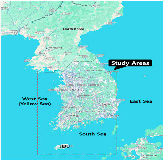
Figure 1.
Study areas for the characteristics of marine traffic.
The Korean Peninsula is connected to China and the mainland, but due to the presence of North Korea, land-based cargo imports and exports are not possible. Due to this, cargo transportation is exclusively conducted via ships or aircrafts. While air freight does take place, goods that require large volumes or bulk transportation, such as raw materials, oil, automobiles, and other industrial items, are all transported by sea. Thus, the role of maritime transportation is crucial in South Korea.
The southwestern waters of South Korea have 31 trade ports (14 nationally managed and 17 locally managed) and 31 coastal ports (12 nationally managed and 19 locally managed). As the term “trade port” implies, these ports are primarily for imports and exports, with not only South Korean-flagged vessels but also numerous foreign-flagged ships entering and departing to transport cargo. However, the locations for OWFs are often developed near areas where ships access ports or in open sea traffic routes where a certain flow of traffic is already established. In other words, a significant portion of OWF development occurs along major shipping lanes, which could require ships to divert their course or encounter blocked entry routes, leading to disruptions in port operations. In such cases, potential solutions include adjusting the location of the wind farm or modifying the location of the traffic routes, as well as designating alternative navigation routes.
In this study, the locations and forms of the alternative navigation routes were presented when the “Maritime-route OWFs clearance rule” was applied to the adjusted OWF areas, reflecting the maritime traffic flow as described above. Since the area is vast, it was divided into eight sections (Sections A~H), and alternative navigation routes were proposed based on the maritime traffic flow and characteristics of each section. The Figure 2 and Table 1 illustrate the target areas for each section and their corresponding coordinates. Except for Figure 1 and Figure 3, the software used to produce Figure 2 and Figure 4 through 20 was developed by a software company based in the Republic of Korea, and the supported language is presented in Korean:
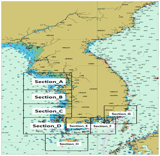
Figure 2.
The locations of each area from Section A to Section H.

Table 1.
Coordinates of each section.
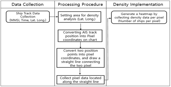
Figure 3.
Procedure for implementing maritime traffic density.
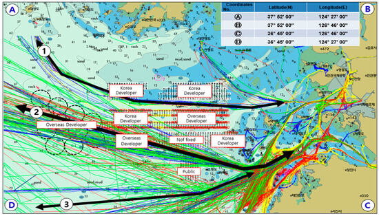
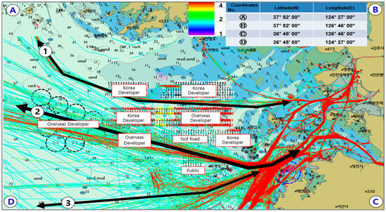
Figure 4.
The location of OWFs, the characteristics of marine traffic, and traffic density for Section A.
3.2. The Location of OWFs, the Characteristics of Marine Traffic, and Traffic Density for Each Section
To proceed with wind power projects, obtaining development project approval from the relevant permitting authorities is necessary. In each section, the points marked with black dashed circles indicate areas where development permits have been granted within a 5 km radius (10 km in diameter), but the placement of wind turbines has not yet been finalized. Once the final development approval is granted, development will proceed as per the designated placement of the turbines. However, when considering traffic flow, a significant overlap exists between the existing traffic flow and the wind farms, necessitating adjustments. The “Maritime route-OWFs clearance rule” should be applied to ensure the appropriate rerouting of maritime traffic. In this chapter, the analysis of maritime traffic flow for each designated area was conducted using the EyeMTAS (Version 3.0.0.7) software developed by GMT. The AIS track data used for the analysis were collected over a seven-day period, from 13 September to 19 September 2023. In this section, the characteristics of navigation route zones based on maritime traffic flow for each area were identified, and traffic-congested areas within the waters were delineated according to traffic density. According to Appendix 4 in [34], the “Scope of Projects Subject to Safety Audit” of the Enforcement Decree of the Maritime Traffic Safety Law of the Republic of Korea, a maritime traffic safety assessment must be conducted to evaluate the navigational safety of vessels when an offshore wind farm is planned in waters where vessels of 100 m or more in length pass an average of four times or more per day. Ohn and Namgung (2022) proposed optimal safe distances between offshore wind farms and vessel traffic routes by applying various parameters. Among these, in cases where vessels exceeding 100 m in length pass an average of four times or more per day, the length of the largest vessel (1 L) was additionally considered in the calculation of the safe distance from the perspective of maritime traffic density [35]. Accordingly, in this section, maritime traffic density was analyzed by identifying traffic congested areas for each evaluation zone, based on the aforementioned regulations and research methods. The analysis of maritime traffic density was conducted following the procedure shown Figure 3.
3.2.1. Section A
Section A is a rectangular area extending from the boundary line connecting Baengnyeong–Yeonpyeong–Incheon–Ganghwa–Incheon to the latitude boundary off the coast of Taean-gun, Chungcheongnam-do. In this area, Route 1 corresponds to the traffic flow of fast ferries operating between Incheon and Baengnyeong Island. Route 2 represents the traffic flow of large passenger and cargo ships traveling from Incheon or Pyeongtaek to northeastern China. Additionally, Route 3 is characterized by the traffic flow of large passenger and cargo ships heading from Incheon or Pyeongtaek to eastern China. Since the wind farm is planned to be developed on both the left and right sides of the Incheon–Baengnyeong Island route, the establishment of a straight-line route for safety is necessary. Furthermore, the development of wind farms is also planned for the left, right, and front sections of the route heading from Incheon and Pyeongtaek to China. In addition, a heat map based on maritime traffic density was created, with areas of high density represented in red and of low density in light blue. All of Route Zones 1 to 3 were found to have high traffic density, characterized by vessels over 100 m in length passing an average of four times or more per day. Particularly, extremely high levels of traffic density were observed along the routes approaching the port. Figure 4 illustrates the wind farm placement, the maritime traffic flow, and the traffic density heat map for Section A.
3.2.2. Section B
Section B is a rectangular area extending from the latitude boundary off the coast of Taean-gun, Chungcheongnam-do, to the latitude boundary off the coast of Gunsan, Jeollabuk-do, and the Saemangeum area. In this area, Route 1 represents the traffic flow from the southern coast or the East China Sea to the eastern ports of the West Sea (such as Incheon, Pyeongtaek, and Daesan). Route 2 corresponds to the traffic flow from Gunsan Port to northeastern Chinese ports. Additionally, Route 3 represents the traffic flow of large passenger and cargo ships traveling from eastern Chinese ports to Incheon and Pyeongtaek. Route 4 corresponds to the traffic flow of large passenger ships operating between Gunsan Port and the northeastern Chinese port of Xidao. Finally, Routes 5 and 6 represent the traffic flow of pilot vessels operating in the coastal navigation area. The wind farms are planned to be developed between the pilot vessel routes, as well as along the sections operating from the East China Sea to Incheon, Pyeongtaek, and Daesan ports and within the area. From the perspective of maritime traffic density, Route Zone 1 was found to be highly congested, with vessels over 100 m in length passing an average of four times or more per day. Meanwhile, Route Zones 2 through 5 demonstrated average levels of traffic density in certain areas. Figure 5 illustrates the wind farm placement, the maritime traffic flow, and the traffic density heat map for Section B.
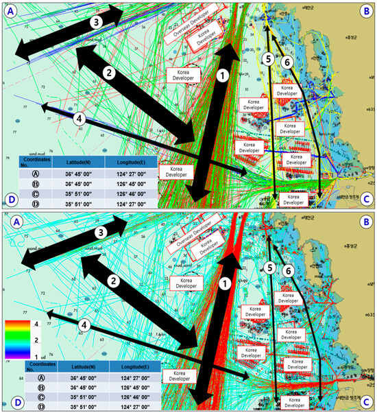
Figure 5.
The location of OWFs, the characteristics of marine traffic, and traffic density for Section B.
3.2.3. Section C
Section C is a rectangular area extending from the latitude boundary off the coast of Gunsan, Jeollabuk-do, and the Saemangeum area to the latitude boundary off the coast of Imjado, Sinan-gun, Jeollanam-do. In this area, Route 1 represents the traffic flow from the southern coast to the eastern ports of the West Sea (such as Incheon, Pyeongtaek, and Daesan). Route 2 corresponds to the traffic flow from the East China Sea to the eastern ports of the West Sea (such as Incheon, Pyeongtaek, and Daesan). Routes 3 and 4 represent the traffic flow of cargo ships traveling from the southern and eastern coasts to northeastern Chinese ports. Route 5 corresponds to the traffic flow of pilot vessels operating in the coastal navigation area. The wind farms are planned to be developed along major traffic routes operating from the East China Sea to Incheon, Pyeongtaek, and Daesan ports, necessitating adjustments to these routes. From the perspective of maritime traffic density, Route Zone 1 was found to be highly congested, characterized by vessels exceeding 100 m in length passing an average of four times or more per day. Furthermore, Route Zones 2 and 5 exhibited generally high traffic density, while Route Zones 3 and 4 demonstrated average levels of traffic density in certain areas. Figure 6 illustrates the wind farm placement, the maritime traffic flow, and the traffic density heat map for Section C.
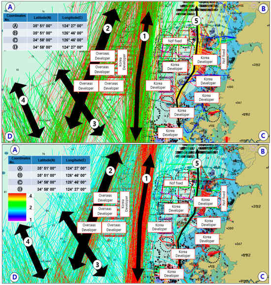
Figure 6.
The location of OWFs, the characteristics of marine traffic, and traffic density for Section C.
3.2.4. Section D
Section D is a rectangular area extending from the latitude boundary off Imjado, Sinan-gun, Jeollanam-do, to the latitude boundary near Chuja-do. In this area, Route 1 represents the traffic flow of vessels traveling from the southern and eastern coasts to the ports of the West Sea. Route 2 corresponds to the traffic flow from Jeju Port or the southern and eastern coasts to the northeastern and eastern ports of China. Routes 3 and 4 represent the traffic flow from the East China Sea to the eastern ports of the West Sea. Route 5 corresponds to the traffic flow from the East China Sea to the northeastern ports of China. Finally, Route 6 represents the traffic flow of small vessels operating along the coastal navigation area from Jeju Port. Several wind farms are planned in areas that overlap with major traffic routes, necessitating adjustments to the traffic flow through the designation of navigation routes. From the perspective of maritime traffic density, Route Zones 1 and 6 were found to be highly congested, characterized by vessels exceeding 100 m in length passing an average of four times or more per day. Moreover, Route Zones 2 through 5 also exhibited generally high traffic density. Figure 7 illustrates the wind farm placement, the maritime traffic flow, and the traffic density heat map for Section D.
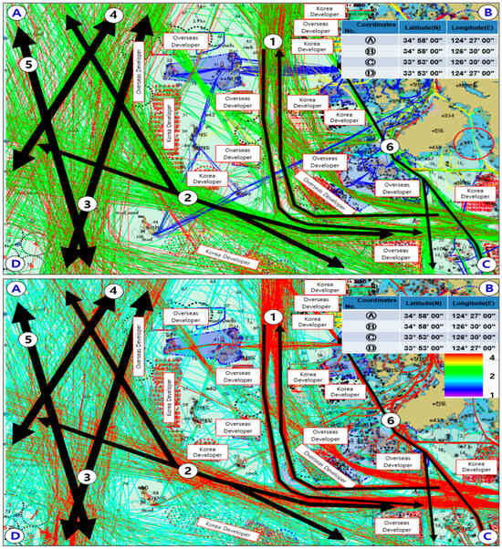
Figure 7.
The location of OWFs, the characteristics of marine traffic, and traffic density for Section D.
3.2.5. Section E
Section E shares the same latitude boundary as Section D at Chuja-do and extends from the longitude boundary of Haenam-gun, Jeollanam-do, to the boundary of Yeosu and Gwangyang ports, forming a rectangular area. In this area, Route 1 represents the traffic flow from major southeastern ports, such as Yeosu, Gwangyang, Busan, and Ulsan, to the ports of the West Sea or the northeastern ports of China. Routes 2 and 3 represent the traffic flow of passenger and cargo vessels traveling from Jeju Port or the East China Sea to Yeosu, Gwangyang, Busan, and Ulsan. Route 4 represents the traffic flow from major Japanese ports to southwestern ports or eastern ports of China. Finally, Route 5 corresponds to the traffic flow of small vessels operating along the coastal navigation area. Wind farms are planned around the major traffic route areas, with some wind farms being located directly in the flow of primary traffic routes. Therefore, adjustments, such as the designation of new navigation routes, will be necessary. From the perspective of maritime traffic density, Route Zones 1, 4, and 5 were found to be highly congested, characterized by vessels exceeding 100 m in length passing an average of four times or more per day. Moreover, Route Zones 2 and 3 also exhibited generally high traffic density. Figure 8 illustrates the wind farm placement, the maritime traffic flow, and the traffic density heat map for Section E.
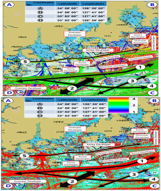
Figure 8.
The location of OWFs, the characteristics of marine traffic, and traffic density for Section E.
3.2.6. Section F
Section F shares the same latitude boundary as Sections D and E at Chuja-do and extends from the longitude boundary of Yeosu and Gwangyang ports to the boundary of Gaduk-do, forming a rectangular area. In this area, Route 1 represents the traffic flow of vessels traveling from trade ports such as Busan and Ulsan to major ports on the West Coast or Jeju Port. Route 2 represents the traffic flow of vessels heading toward Masan and Jinhae ports. Route 3 represents the traffic flow of vessels traveling from Yeosu and Gwangyang ports to the East China Sea. Route 4 represents the traffic flow of vessels traveling from major Japanese ports to Masan and Jinhae ports. Finally, Route 5 represents the traffic flow of vessels traveling from major Japanese ports to the West Coast or eastern ports of China. Wind farms are planned around the primary traffic route areas in this section, and some wind farms are located directly along the main traffic flow, necessitating adjustments, such as the designation of new navigation routes. From the perspective of maritime traffic density, Route Zones 1 to 3 were found to be highly congested, characterized by vessels over 100 m in length passing an average of four times or more per day. Moreover, Route Zones 4 and 5 also demonstrated generally high traffic density. Figure 9 illustrates the wind farm placement, the maritime traffic flow, and the traffic density heat map for Section F.
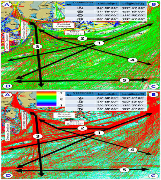
Figure 9.
The location of OWFs, the characteristics of marine traffic, and traffic density for Section F.
3.2.7. Section G
Section G forms a rectangular area extending from the longitude boundary of Tongyeong, Gyeongsangnam-do, to the waters off Ulsan Metropolitan City. In this area, Routes 1 and 2 represent the traffic flow of vessels traveling from major ports on the East Coast, such as Ulsan, to the West Coast or eastern ports of China. Route 3 represents the traffic flow of vessels traveling from major Japanese ports to Ulsan Port. Route 4 represents the traffic flow of large passenger ships and cargo vessels traveling from major Japanese ports to Busan Port. Wind farms are planned to be developed along the route between Ulsan, Busan, and the South West Coast, necessitating adjustments, such as the designation of navigation routes. From the perspective of maritime traffic density, all of the route zones (Routes 1 to 4) were found to be highly congested, as vessels exceeding 100 m in length passed an average of four times or more per day. Figure 10 illustrates the wind farm placement, the maritime traffic flow, and the traffic density heat map for Section G.
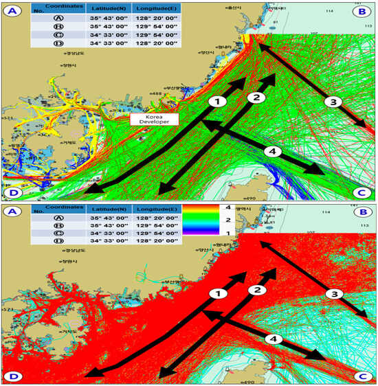
Figure 10.
The location of OWFs, the characteristics of marine traffic, and traffic density for Section G.
3.2.8. Section H
Section H is defined as a rectangular area surrounding Jeju Island. In this area, Routes 1 and 3 represent the traffic flow of vessels traveling from the East China Sea to Yeosu, Gwangyang, as well as the ports of Busan and Ulsan. Route 2 represents the traffic flow of vessels traveling from the East China Sea to Yeosu and Gwangyang ports. This section is particularly characterized by the intersection of traffic flows, including those heading from Yeosu and Gwangyang ports to the East China Sea, vessels entering and departing from Jeju Port, and vessels traveling in an east–west direction. These intersecting flows pose a potential risk of collisions. However, the wind farms are planned to be located close to the coastline, which has been reviewed to not significantly interfere with the flow of traffic. From the perspective of maritime traffic density, both Route Zones 2 and 3 were found to be highly congested, with vessels exceeding 100 m in length passing an average of four times or more per day. Meanwhile, Route Zone 1 demonstrated an average level of traffic density in certain areas. Figure 11 illustrates the wind farm placement, the maritime traffic flow, and the traffic density heat map for Section H.
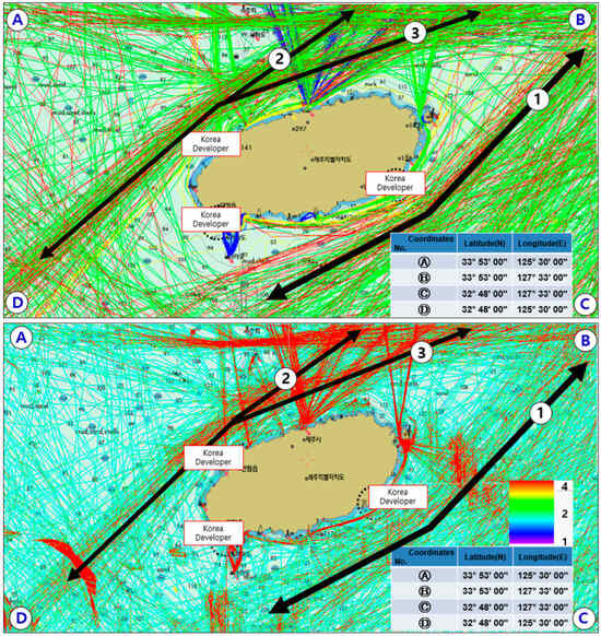
Figure 11.
The location of OWFs, the characteristics of marine traffic, and traffic density for Section H.
4. Conception of Terms and Methodology
4.1. Definition of Navigation Routes
4.1.1. Marine High-Speed Shipping Route
A marine high-speed shipping route refers to the major traffic flow connecting key ports along the coast or major ports to international ports. It is conceptually similar to a maritime highway, which is akin to highways in road traffic. In marine high-speed traffic routes, vessels do not enter ports but instead sail at a constant speed, maintaining a “run-up engine” and “navigation full ahead” state without changes in velocity.
4.1.2. Marine Feeder Shipping Route
A marine feeder shipping route refers to the traffic flow of relatively smaller vessels operating in coastal waters or the traffic flow connecting the major maritime routes. It is conceptually defined as the maritime equivalent of a provincial route or expressway in road traffic. In marine feeder shipping routes, vessels navigate in a “run-up engine” state with no change in speed when traveling through outer sections that do not approach ports or connect major maritime routes. However, when approaching entry and exit routes to ports, the vessels navigate in a “stand-by engine” state, preparing the main engine for entry.
4.1.3. Port Entry and Exit Approach Route
The port entry and exit approach route connects marine high-speed traffic routes to marine feeder shipping routes and is used by vessels approaching ports for entry or exit. This route can be compared to local roads or city roads in road traffic. In this traffic route, vessels navigate with the main engine in a “standby” state.
4.1.4. Recommended Route
The recommended route is a designated route set between wind farms or islands within coastal traffic lanes for the safe operation of small vessels, such as feeder ships, that are significantly affected by sea swells. In this recommended route, buoys or similar markers are installed along the central part of the route to allow safe two-way passage and help separate traffic flows, thereby improving the safety of vessel operations.
4.2. Design Methodology of the Routes
4.2.1. The PIANC Rule
According to the Harbour Approach Channels Design Guidelines, the PIANC Rule (2014) [36], various parameters for route design are specified. In particular, to determine the horizontal width, additional factors such as environmental conditions (wave height, wind, and current), vessel speed, seabed conditions, depth, and slope should be considered and applied. In this study, to establish the width of alternative routes due to wind farm development, the route width was adjusted by comprehensively considering various environmental forces, vessel maneuverability, vessel speed, depth/draft (h/d), and the possibility of two-way traffic. The following formula represents the required width for one-way traffic:
The following formula below describes the required width for two-way traffic:
Here, is the width of the basic maneuvering lane as a multiple of the design ship’s beam B, as shown in Table 2. represents additional widths to allow for the effects of wind, current, etc., as shown in Table 3. represents the passing distance by comparing the sum of a separation distance between both maneuvering lane and an additional distance for traffic density, as shown in Table 4. are the bank clearance on the “red” and “green” sides of the channel, as illustrated in Table 5.
Table 2.
Basic maneuvering lane WBM.
Table 3.
Additional width Wi for straight channel sections.
Table 4.
Additional widths for passing distance in two-way traffic.
Table 5.
Additional widths for bank clearance.
Here, the maneuverability for each vessel type, , is given in Table 2. The maneuverability of hazardous cargo vessels and bulk carriers is generally considered “Poor,” while container ships, car carriers, roll-on/roll-off (ro-ro) ships, and liquefied natural gas (LNG) and liquefied petroleum gas (LPG) vessels are considered average. Twin propeller ships, ferries, and cruise ships are considered to have good maneuverability.
4.2.2. The PIANC Guidelines
In this study, to ensure the safe operation of vessels navigating in the waters surrounding OWFs to be developed in South Korean waters, the PIANC Guidelines (2018), which specify a safe separation distance (presented in Table 6), were followed.
Table 6.
Safety distance between OWFs and ships.
As stated in Table 6, when the wind farm is located on the starboard side of the vessel, 0.3 NM is added compared to when it is on the port side. This adjustment accounts for the phenomenon of the vessel drifting to the left at the beginning of a turn due to the characteristics of the vessel’s turning propulsion. While left-handed propellers (LHPs) are also in use, the majority of operational vessels are equipped with right-handed propellers (RHPs). Accordingly, the PIANC Guideline presumes right-handed single-screw vessels as a baseline condition. Additionally, 6 L, which is six times the length of the ship, incorporates the 1 L safety margin added to 5 L, as specified in the IMO maneuvering standards. Also, 500 m refers to the safety zone size specified by the UNCLOS. However, since vessel navigation follows the principle of port-to-port navigation according to the COLREGs and the wind farm is always located on the starboard side of the vessel, this study applied a separation distance of “6 L + 0.3 NM + 500 m” for the wind farm when located on the vessel’s starboard side.
5. Suggestion of an Alternative Passage at the OWF Area
OWFs are planned for development in various areas, including the coastal waters and distant seas of South Korea. Consequently, the conventional trade routes between major ports, port entrances and exits, and offshore passage areas will no longer be fully usable. Therefore, the existing customary navigation routes have been relocated around the areas where wind farms are planned for development and the waters between the wind farms. The relocated alternative navigation routes apply the standard of “6 L + 0.3 NM + 500 m” when the wind farm is located on the starboard side, as outlined in the PIANC Guidelines. Vessel navigation follows the principle of port-to-port navigation, including TSS and designated crossing routes, and ships are always expected to approach wind farms from the starboard side. Based on this principle, an appropriate distance was maintained, and the navigation routes were arranged accordingly. Figure 12 demonstrates the alternative navigation routes due to the development of OWFs across South Korea.
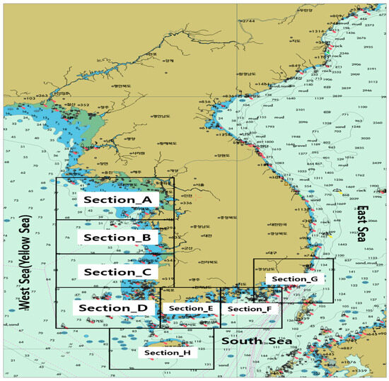
Figure 12.
Alternative passage in accordance with the development of OWFs.
As described in Section 4, maritime traffic routes can be broadly categorized into four types: the marine high-speed shipping route, which is the major traffic route connecting key ports or major ports to international ports; the marine feeder shipping route, which connects marine high-speed shipping routes; the port entry and exit approach route; and the recommended route. As defined and described in Section 4, each proposed traffic route is categorized according to its name and function, based on the geographical characteristics of the sea area and the interconnectivity between navigational routes. This approach parallels the concept of road traffic systems for automobiles in land-based transportation. The offshore areas and coastal waters adjacent to ports exhibit clear differences in vessel speed depending on the readiness of the main engine, which is influenced by traffic density and the frequency of multi-ship encounters depending on their proximity to ports. Considering these constraints, the function assigned to each route reflects the operational status of vessels. Therefore, vessel navigation within the proposed routes defined according to the functions and characteristics outlined in Section 4 is expected to ensure safe passage in sea areas developed for offshore wind farms.
5.1. An Alternative Passage and the Locations of OWFs for Each Section
5.1.1. Section A
In Section A, a recommended route was established in the waters between the OWFs planned on the Incheon–Baengnyeong Island route, on both the left and right sides of the route. This area is primarily used by relatively smaller vessels such as fast ferries, so instead of setting a fixed width for the route, a recommended route was proposed to allow exclusive use. Additionally, for large fast ferries or cargo vessels operating between Incheon or Pyeongtaek ports and northeastern China, the maritime route–OWF clearance rule was applied to the south side of the development area to ensure appropriate clearance before setting the marine feeder shipping route. This marine feeder shipping route uses TSS to ensure safe passage and was configured to merge with the first marine high-speed shipping route. Figure 13 demonstrates the layout of OWFs and surrounding alternative navigation routes for Section A.
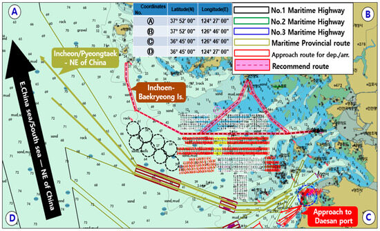
Figure 13.
Arrangement of the alternative passage and the locations of OWFs for Section A.
5.1.2. Section B
In Section B, a marine feeder shipping route was proposed to avoid the OWFs to be developed on the western side of Taean Port, connecting the northern route from Incheon and Pyeongtaek ports to the eastern Chinese ports. A similar route was also established on the southern side of the OWFs to be developed northwest of Gunsan Port, heading toward the eastern and northeastern Chinese ports. Additionally, the existing Maemul–Sudo TSS was extended to establish the third marine high-speed shipping route in a straight line, enabling vessels to head toward Incheon, Pyeongtaek, and Daesan ports. Furthermore, a second marine high-speed shipping route was established in a straight line on the western side of the third route, allowing vessels from the East China Sea and southern coastal ports to operate toward Daesan, Incheon, and Pyeongtaek ports. Finally, a recommended route was established to avoid the OWFs to be developed southeast of Gunsan Port, providing a route for small vessels, such as fast ferries, in the coastal navigation area. Figure 14 illustrates the layout of the OWFs and surrounding alternative navigation routes for Section B.
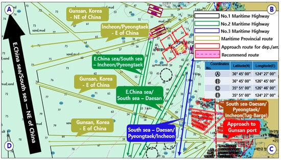
Figure 14.
Arrangement of the alternative passage and the locations of OWFs for Section B.
5.1.3. Section C
In Section C, due to the planned development of a large-scale OWF south of Gunsan Port, a third marine high-speed shipping route was established by extending the existing Maemul–Sudo TSS westward, allowing navigation toward Daesan, Pyeongtaek, and Incheon ports. As outlined in Section B, a second marine high-speed shipping route was configured to the west of the third marine highway, facilitating navigation from the East China Sea and southern coastal ports to Daesan, Pyeongtaek, and Incheon ports. A marine feeder shipping route was established between the second and third marine high-speed shipping routes to facilitate navigation from the southern coastal regions to northeastern Chinese ports. Additionally, at the terminus of the marine feeder shipping route, provisions were made to integrate it with the first marine high-speed shipping route, which operates from the East China Sea and southern coastal ports to northeastern Chinese ports. Finally, a recommended route was designated within the coastal traffic zone to the east of the third marine high-speed shipping route, enabling small vessels, such as tender boats, to navigate the waterway between the large-scale OWFs. Figure 15 illustrates the configuration of the OWFs and the surrounding alternative navigation routes for Section C.
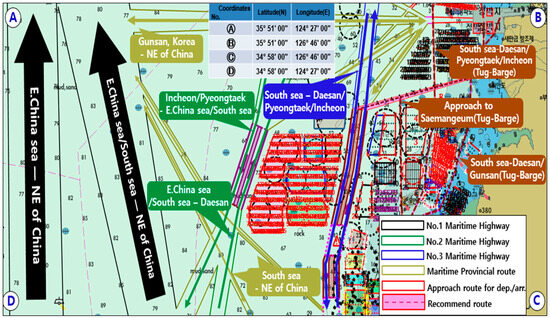
Figure 15.
Arrangement of the alternative passage and the locations of the OWFs for Section C.
5.1.4. Section D
As in Section C, a large-scale OWF is planned for development from the southern part of Gunsan Port to the southwestern part of Jindo. Consequently, a third marine high-speed shipping route was established by extending the existing Maemul–Sudo TSS westward, enabling navigation toward Daesan, Pyeongtaek, and Incheon ports. Additionally, a second marine high-speed shipping route was configured south of the third marine high-speed shipping route, creating a passage to northeastern China from the southern coast, as well as a route to Daesan Port on the west coast. A marine feeder shipping route was established between the second and third marine high-speed shipping routes, and the terminus of the second marine high-speed shipping route on the western side was connected to the first marine high-speed shipping route, which leads to northeastern Chinese ports. To the east of the third marine high-speed shipping route, a feeder shipping route was designated within the waters between the OWFs, allowing small vessels, such as tender boats, to utilize the coastal traffic zones. Figure 16 illustrates the configuration of OWFs and the surrounding alternative navigation routes for Section D.
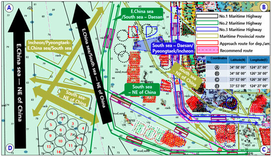
Figure 16.
Arrangement of the alternative passage and the locations of the OWFs for Section D.
5.1.5. Section E
In Section E, a large-scale OWF is planned for development on the east and west sides of Wando Port. Consequently, a marine feeder shipping route was established by extending the existing east–west recommended route to the south. Additionally, dedicated routes for passenger vessels operating regularly between Goheung and Yeosu Dolsando were established to avoid wind farms. To the south of the east–west recommended route, a large-scale OWF is expected to be developed. The “Maritime route-OWFs clearance rule” was applied, and the existing Yeokman-do–Bogildo TSS was extended to establish the third marine high-speed shipping route. To the south of the third marine high-speed shipping route, the second marine high-speed shipping route was set, and a marine feeder shipping route connecting the two high-speed routes was established, allowing navigation toward Yeosu, Busan, and Ulsan to the northeast and Daesan, Pyeongtaek, and Incheon to the northwest. Figure 17 illustrates the configuration of the OWFs and the surrounding alternative navigation routes for Section E.
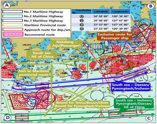
Figure 17.
Arrangement of the alternative passage and the locations of the OWFs for Section E.
5.1.6. Section F
In Section F, there is considerable traffic volume at the entry points to Yeosu and Gwangyang ports, necessitating the establishment of entry routes and other related navigation paths. The existing Hongdo TSS was connected to the Yeokman-do TSS and was designated as a general route, and the area where the marine feeder shipping route connects the second and third marine high-speed shipping routes was designated as a cautionary area. Furthermore, to ensure the safe passage of smaller vessels, such as pilot boats, the marine feeder shipping route was extended, and a cautionary area was established at the confluence of the routes entering and exiting Yeosu and Gwangyang ports. Figure 18 illustrates the configuration of the OWFs and the surrounding alternative navigation routes for Section F.
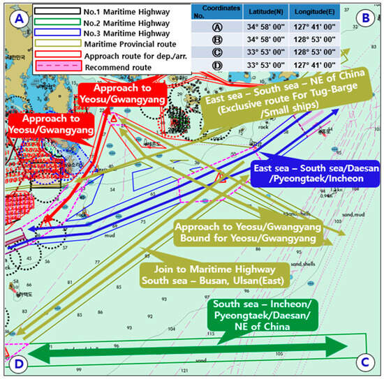
Figure 18.
Arrangement of the alternative passage and the locations of the OWFs for Section F.
5.1.7. Section G
In Section G, as mentioned in Section F, the marine feeder shipping route was extended and established to ensure the safe passage of smaller vessels, such as pilot boats. Additionally, an approach route was set up to avoid the OWFs for vessels entering Yeosu and Gwangyang ports. Currently, there are no plans for OWF development to the northeast of the Hongdo TSS; thus, the marine high-speed shipping routes were not connected. Figure 19 illustrates the configuration of the OWFs and the surrounding alternative navigation routes for Section G.
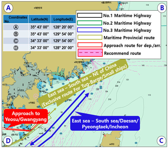
Figure 19.
Arrangement of the alternative passage and the locations of the OWFs for Section G.
5.1.8. Section H
In Section H, the marine feeder shipping routes are divided into five segments, passing through or merging with the second marine high-speed shipping route from Jeju Port to Incheon, Pyeongtaek, Daesan, and ports in northeastern China, as well as to Yeosu-Gwangyang, Busan, and Ulsan. As demonstrated in Figure 19, the marine feeder shipping routes are set in a straight-line configuration to follow the shortest possible distance. Should OWFs be developed in this area in the future, adjustments will be necessary. Figure 20 illustrates the arrangement of the OWFs and the surrounding alternative navigation routes for Section H.
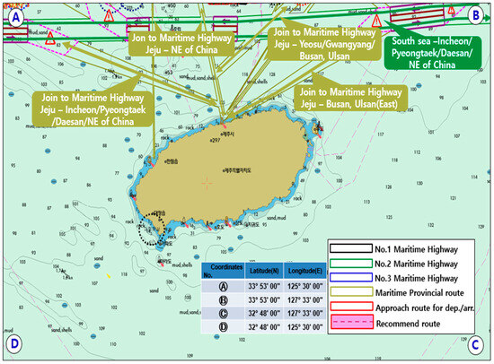
Figure 20.
Arrangement of the alternative passage and the locations of the OWFs for Section H.
5.2. Discussion
In the maritime areas designated for offshore wind farm development, wind turbines may pose navigational hazards to the safe operation of vessels. Therefore, this study aimed to secure safe separation distances between ships and offshore wind turbines. To achieve this, relevant domestic and international regulations and guidelines were reviewed and compared, with the implementation standards based on the Korean Maritime Traffic Safety Act applied. After securing safe separation distances, this study then sought to establish suitable route widths to maintain existing vessel traffic flow. For this purpose, various factors specified in the PIANC guidelines were utilized. Furthermore, the maritime routes were categorized into maritime highways, maritime provincial routes, approach routes for departure/arrival, and recommended routes, depending on their function in connecting major trading ports and the operational status of the main engine (M/E).
This study aimed to ensure the safe navigation of vessels by proposing alternative routes in adjacent waters in preparation for the potential development of large-scale offshore wind farms in designated maritime zones. By simultaneously applying the Guidelines for Distance between Maritime Traffic Routes and Offshore Wind Farms and the Standards for Route Design, this research established navigation routes and traffic separation schemes (TSSs) in areas adjacent to offshore wind farm zones. This integrated approach distinguishes this study from previous research in the field. Previous studies have primarily focused on determining the optimal siting of offshore wind farms using various methodologies and have employed quantitative evaluation techniques such as risk assessments of vessel navigation and collision probability analyses. However, they have generally not proposed practical safety measures, such as the designation of alternative routes that ensure the continuity of existing maritime traffic flows. In contrast, while this study does not incorporate advanced quantitative analytical methods such as clustering-based algorithms widely used in recent research, it aims to address practical aspects of navigational safety. Nonetheless, the implementation guidelines based on the Maritime Traffic Safety Act, which were applied to determine safe separation distances between offshore wind farms and vessels, have inherent limitations. These guidelines do not sufficiently account for variations in lateral dimensions according to ship type and main engine (M/E) status at specific locations, nor do they reflect the influence of environmental forces or ship encounter scenarios on evasive maneuvering areas. Moreover, the PIANC Rule adopted as the methodological basis for route width design uniformly categorizes vessel maneuverability (good, moderate, and poor) by ship type, which may not adequately represent the full diversity of vessels in practice. Therefore, further in-depth studies are necessary to address these limitations. Furthermore, although this study proposed alternative navigation routes aimed at maintaining existing traffic flows following the development of offshore wind farms, it has a limitation in that a clear validation framework, such as simulation-based verification, has not been presented. In the future, detailed studies are required to verify the safety of navigation in the proposed alternative routes developed in response to offshore wind farm projects in Korean waters. This includes applying actual environmental force conditions of the sea area and deploying representative vessels within ship maneuvering simulations to assess the feasibility of safe navigation.
6. Conclusions
As OWFs are scheduled to be developed in the waters of the Republic of Korea in the future, vessels that currently use customary navigation routes will face reduced efficiency, as they will need to detour around wind turbine structures. Additionally, since these routes have not been designated, safety cannot be ensured. Therefore, in this study, alternative navigation routes were proposed to replace the existing customary routes, considering efficiency and ensuring that the alternative routes align with the current traffic flow, without being too far apart. The established routes reflect the clearance rule of 6 L + 0.3 NM + 500 m, as specified in the “Maritime route-OWFs clearance rule.”
The established navigation routes are broadly categorized into four types. The first is the marine high-speed shipping routes, which are the main navigation routes connecting major trade ports within the Republic of Korea or leading to key overseas trade ports. The second is the marine feeder shipping route, which connects the traffic flow of vessels operating in coastal waters or between marine high-speed shipping routes. The third is the port entry and exit approach route, which refers to the approach sections for vessels entering and exiting ports. Finally, the fourth is the recommended route, designed to ensure safe navigation for small vessels, such as tenders, that operate in coastal traffic lanes rather than in deep seas due to the influence of waves. Each route can be used by vessels traveling in different directions, but they are categorized into TSS and recommended routes, with traffic flows that are either distinguishable or undistinguishable in the case of generally designated routes. In response to the significant shift in energy policies, many countries surrounding the oceans, including the Republic of Korea, will develop large-scale OWFs to take advantage of marine resources. Accordingly, this study proposed alternative navigation routes to ensure the safe navigation of numerous vessels operating in sea areas designated for offshore wind farm development. The designation of routes, reflecting the current traffic flow, will help prevent marine accidents through the application of international and domestic clearance rules and will enable more efficient monitoring to prevent safety incidents. However, this study does not incorporate advanced analytical methodologies commonly employed by many researchers in the field of maritime navigation. Moreover, the implementation guidelines based on the Maritime Traffic Safety Act, which were used to determine safe separation distances between offshore wind farms and vessels, have clear limitations. These guidelines do not account for critical factors such as vessel-specific maneuverability, variations in lateral clearance according to the operational status of main engines (M/Es), or the influence of external environmental forces. Furthermore, this study has a limitation in that it does not present a quantitative validation framework such as simulation-based analysis for the proposed alternative navigation routes. To address this, future research will aim to establish a systematic and comprehensive safe separation distance between offshore wind farms and vessels by considering various ship types, turning radii reflecting the characteristics of main engines, and the operational status of main engines (M/Es) depending on the siting characteristics of offshore wind farms. In addition, the verification of navigational safety will be conducted through ship maneuvering simulations by utilizing real-world environmental forces and a structured database that includes information on representative vessels and offshore wind farm developments.
Author Contributions
Conceptualization, S.-W.O. and H.N.; methodology, S.-W.O.; software, H.N.; validation, H.N.; formal analysis, S.-W.O.; investigation, H.N.; resources, S.-W.O.; data curation, H.N.; writing—original draft preparation, S.-W.O.; writing—review and editing, H.N.; visualization, H.N.; supervision, S.-W.O.; project administration, S.-W.O. All authors have read and agreed to the published version of the manuscript.
Funding
This research received no external funding.
Data Availability Statement
The data that support the findings of this study are available from the corresponding author upon reasonable request.
Conflicts of Interest
The authors declare no conflicts of interest.
Abbreviations
The following abbreviations are used in this manuscript:
| OWF | Offshore wind farm |
| PIANC | Permanent International Association of Navigation Congresses |
| GIS | Geographic Information System |
| AHP | Analytical hierarchical process |
| MCDM | Multi-criteria decision-making |
| TOPSIS | Technique by for Order Preference by Similarity to Ideal Solution |
| IAHP | Interval analytical hierarchy process |
| ELECTRE-III | Elimination et Choix Traduisant La Réalité-III |
| TSS | Traffic separation scheme |
| COLREGs | Convention on the International Regulations for Preventing Collisions at Sea |
| UNCLOS | United Nations Convention on the Law of the Sea |
| MLIT | Ministry of Land, Infrastructure, Transport and Tourism |
| Ro-ro | Roll-on/roll-off |
| LNG | Liquefied natural gas |
| LPG | Liquefied petroleum gas |
| IMO | International Maritime Organization |
References
- Ohn, S.W. A Study on Model Development for the Navigation Safety of Offshore Wind Farm and Vessel. Ph.D. Thesis, Mokpo National Maritime University, Mokpo, Republic of Korea, 2022. [Google Scholar]
- Ministry of Trade, Industry and Energy, Presentation of the Renewable Energy 3020 Implementation Plan Draft. Available online: http://www.motie.go.kr/kor/article/ATCL3f49a5a8c/159996/view (accessed on 1 February 2025).
- Ministry of Science and ICT. Presentation of the 2050 Strategy for Carbon Neutrality Implementation. Available online: http://www.msit.go.kr/bbs/view.do?sCode=user&mId=113&mPid=112&pageIndex=2&bbsSeqNo=94&nttSeqNo=3179667&searchOpt=ALL&searchTxt= (accessed on 3 February 2025).
- GWEC. Global Wind Report 2024. Available online: http://www.gwec.net/reports (accessed on 15 February 2025).
- An RWE Innogy Company. The Triton Knoll Offshore Wind Farm Marine Navigational Safety Risk Assessment for RWE Npower Renewables Ltd.; Strategic Marine Services Ltd.: Chester, UK, 2011; pp. 36–40. [Google Scholar]
- Kingfisher Information Service. Kingfisher Wind Farm Chart, Greater Gabbard Offshore Wind Farm; KIS-ORCA: Grimsby, UK, 2025; pp. 1–3. [Google Scholar]
- Sánchez-Lozano, J.M.; García-Cascales, M.S.; Lamata, M.T. Identification and Selection of Potential Sites for Onshore Wind Farms Development in Region of Murcia, Spain. Energy 2014, 73, 311–324. [Google Scholar] [CrossRef]
- Kim, J.H.; Ryu, G.H.; Kim, Y.G.; Kim, S.M.; Moon, C.J. Selecting the Geographical Optimal Safety Site for Offshore Wind Farms to Reduce the Risk of Coastal Disasters in the Southwest Coast of South Korea. J. Korea Inst. Electron. Commun. Sci. 2022, 17, 1003–1011. [Google Scholar] [CrossRef]
- Konstantinos, I.; Georgios, T.; Garyfalos, A. A Decision Support System Methodology for Selecting Wind Farm Installation Locations Using AHP and TOPSIS: Case Study in Eastern Macedonia and Thrace Region, Greece. Energy Policy 2019, 132, 232–246. [Google Scholar] [CrossRef]
- Ayodele, T.R.; Ogunjuyigbe, A.S.O.; Odigie, O.; Munda, J.L. A Multi-Criteria GIS Based Model for Wind Farm Site Selection Using Interval Type-2 Fuzzy Analytic Hierarchy Process: The Case Study of Nigeria. Appl. Energy 2018, 228, 1853–1869. [Google Scholar] [CrossRef]
- Xu, Y.; Li, Y.; Zheng, L.; Cui, L.; Li, S.; Li, W.; Cai, Y. Site Selection of Wind Farms Using GIS and Multi-Criteria Decision Making Method in Wafangdian, China. Energy 2020, 207, 118222. [Google Scholar] [CrossRef]
- Wu, B.; Yip, T.L.; Xie, L.; Wang, Y. A Fuzzy-MADM Based Approach for Site Selection of Offshore Wind Farm in Busy Waterways in China. Ocean Eng. 2018, 168, 121–132. [Google Scholar] [CrossRef]
- Lee, J.-S.; Son, W.-J.; Lee, H.-T.; Cho, I.-S. A Study on the Factors Affecting Optimal Site of Offshore Wind Farm from the Perspective of Maritime Traffic using Spatial Analysis. J. Coast. Disaster Prev. 2020, 2, 85–96. [Google Scholar] [CrossRef]
- Lee, B.-K.; Cho, I.-S.; Kim, D.-H. A Study on the Design of the Grid-Cell Assessment System for the Optimal Location of Offshore Wind Farms. J. Korean Soc. Mar. Environ. Saf. 2018, 24, 848–857. [Google Scholar] [CrossRef]
- Kwon, Y.-M.; Lee, C.-H.; Rim, G.-S. A Review of Vessel Traffic and Fishing Activity Standards for Offshore Wind Farm in Domestic Areas Based on the Analysis of Foreign Cases. J. Korean Soc. Mar. Environ. Saf. 2018, 24, 29–35. [Google Scholar] [CrossRef]
- Yang, H.-S.; Lee, C.-H.; Rim, G.-S. Study on the Vessel Traffic Safety Assessment for Routeing Measures of Offshore Wind Farm. J. Korean Soc. Mar. Environ. Saf. 2014, 20, 186–192. [Google Scholar] [CrossRef][Green Version]
- Qing, Y.; Kezhong, L.; Teixeira, A.P.; Soares, C.G. Assessment of the Influence of Offshore Wind Farms on Ship Traffic Flow Based on AIS Data. J. Navig. 2020, 73, 131–148. [Google Scholar] [CrossRef]
- Rawson, A.; Rogers, E. Assessing the Impacts to Vessel Traffic from Offshore Wind Farms in the Thames Estuary. Sci. J. Marit. Univ. Szczec. 2015, 43, 99–107. [Google Scholar]
- Tsai, Y.-M.; Lin, C.-Y. Investigation on improving strategies for navigation safety in the offshore wind farm in Taiwan Strait. J. Mar. Sci. Eng. 2021, 9, 1448. [Google Scholar] [CrossRef]
- Son, W.-J.; Cho, I.-S. Optimal Maritime Traffic Width for Passing Offshore Wind Farms based on Ship Collision Probability. Ocean Eng. 2024, 313, 119498. [Google Scholar] [CrossRef]
- Yan, K.; Wang, Y.; Wang, W.; Qiao, C.; Chen, B.; Jia, L. A System-Theory and Complex Network-Fused Approach to analyse Vessel-Wind Turbine Allisions in Offshore Wind Farm Waters. J. Mar. Sci. Eng. 2023, 11, 1306. [Google Scholar] [CrossRef]
- Gao, H.; Xie, C.; Liu, K.; Chen, S.; Zhou, L.; Liu, Z.; Wang, R. Modeling of Safe Distance Between Ship Routes and Offshore Wind Farm Based on Tolerable Collision Probability. IEEE 2022, 10, 71777–71790. [Google Scholar] [CrossRef]
- Rawson, A.; Brito, M. Assessing the Validity of Navigation Risk Assessment: A Study of Offshore Wind Farms in the UK. Ocean Coast. Manag. 2022, 219, 106078. [Google Scholar] [CrossRef]
- Marcjan, K.; Kotkowska, D. Identification of Navigational Risks Associated with Wind Farms. Eur. Res. Stud. J. 2023, 26, 595–611. [Google Scholar] [CrossRef]
- Mehdi, R.-A.; Schröder-Hinrichs, J.-U.; Baldauf, M. A Tale of Two Industries: Seafarer Perceptions of Navigational Safety Risks Near Offshore Wind Farms. Ocean Yearb. Online 2019, 33, 543–581. [Google Scholar] [CrossRef]
- Al-Quhali, M.-A.; Baldauf, M.; Fiorini, M. Enhanced Maritime Spatial Planning through VTS. In Proceedings of the 2018 16th International Conference on Intelligent Transportation Systems Telecommunications (ITST), Lisbon, Portugal, 15 October 2018. [Google Scholar]
- Bai, X.; Cheng, L.; Iris, C. Data-Driven Financial and Operational Risk Management: Empirical Evidence from the Global Tramp Shipping Industry. Transp. Res. Part E Logist. Transp. Rev. 2022, 158, 102617. [Google Scholar] [CrossRef]
- Maritime Traffic Safety Law, Article 13 (Maritime Traffic Safety Audit). Available online: http://www.law.go.kr/IsSc.do?menuld=1&submenuld=15&tabmenuld=81&eventGubun=060114#undefined (accessed on 26 February 2025).
- Ministry of Oceans and Fisheries (MOF). Marine Safety Audit Implementation Guidelines; Appendix [3]; Technical Standards for each Safety Audit Item; Ministry of Oceans and Fisheries: Seoul, Republic of Korea, 2022. [Google Scholar]
- PIANC. Interaction Between Offshore Wind Farms and Maritime Navigation; PIANC: Brussels, Belgium, 2018. [Google Scholar]
- International Regulations for Preventing Collisions at Sea, 1972, Article 8 (Action to Avoid Collision). Available online: http://www.imo.org/en/About/Conventions/Pages/COLREG.aspx (accessed on 25 February 2025).
- United Nations. Article 60, Artificial Islands, Installations, and Structures in the Exclusive Economic Zone. In United Nations Convention on the Law of the Sea; United Nations: New York, NY, USA, 1982. [Google Scholar]
- PIANC. Technical Guidelines for Offshore Wind Power Generation Facilities in Ports, Interaction Between Offshore Wind Farms and Maritime Navigation; PIANC: Brussels, Belgium, 2018. [Google Scholar]
- Enforcement Decree of the Maritime Traffic Safety Law, Appendix [4]: Scope of Projects Subject to Safety Audit. Available online: http://www.law.go.kr/IsSc.do?menuld=1&sunmenuld=15&tabmenuld=81&query=#J16390335 (accessed on 26 February 2025).
- Ohn, S.-W.; Namgung, H. Development of a Calculation Model for an Optimal Safe Distance between Ship Routes and Offshore Wind Sites. J. Korean Soc. Mar. Environ. Saf. 2022, 28, 973–991. [Google Scholar] [CrossRef]
- PIANC. Rule, Harbour Approach Channels Design Guidelines; PIANC: Brussels, Belgium, 2014. [Google Scholar]
Disclaimer/Publisher’s Note: The statements, opinions and data contained in all publications are solely those of the individual author(s) and contributor(s) and not of MDPI and/or the editor(s). MDPI and/or the editor(s) disclaim responsibility for any injury to people or property resulting from any ideas, methods, instructions or products referred to in the content. |
© 2025 by the authors. Licensee MDPI, Basel, Switzerland. This article is an open access article distributed under the terms and conditions of the Creative Commons Attribution (CC BY) license (https://creativecommons.org/licenses/by/4.0/).