Abstract
Storm surges represent a prominent and significant natural hazard in the coastal areas of China and cause substantial human and economic losses. We investigated historical storm surge events in these areas to assess the distribution of associated hazards and to construct a storm surge hazard index. The tide-gauge data from 83 observational stations along the Chinese coast were collected, and the assessment was based on two indicators, namely the storm surge height and the exceeded water warning level of these events. Further, we conducted a vulnerability assessment of coastal counties in China using population and economic distribution data. Thereafter, the distribution of storm surge hazards and vulnerability levels was considered, and we determined the county-level risk of storm surges covering 219 coastal counties in China. The findings revealed substantial spatial variations therein, with high-risk areas in terms of the population and economic effects of such surges accounting for 25.1% (55/219) and 27.4% (60/219) of all coastal counties, respectively. These results provide preliminary insight into storm surge risks in China and have implications for the prevention and mitigation of storm surges for central government.
1. Introduction
In China, devastating marine disasters, particularly storm surges [1,2,3], can potentially occur in every season and affect all regions of the coastline from south to north. Storm surge events are prone to causing coastal flooding and substantial casualties and economic losses in coastal areas [4,5,6]. The available statistical data indicate that storm surges have caused more than 90% of all direct economic losses from marine disasters on the Chinese mainland since 1989 [7,8,9]. The most destructive storm surge was caused by Typhoon Winnie in 1997 that claimed the life of 1482 people and caused economic losses of over RMB 26.1 billion in Zhejiang, Fujian, Shandong and Hebei Provinces [10]. It is critical to carry out storm surge disaster risk assessments to improve the disaster prevention and mitigation ability of storm surge disaster-prone areas [11].
Accordingly, it is crucial to investigate the distribution of storm surge disaster risks in coastal areas [12,13,14,15]. Traditional storm surge hazard assessments have been conducted at the site scale using historical tide-gauge observational data and statistical analysis methods [9,16]. For local-scale assessments, such as using a county as a study area, high-precision numerical models are often employed to evaluate storm surge inundation, which can be used in conjunction with regional land use and land cover data to conduct storm surge vulnerability assessments [17,18,19]. Large-scale storm surge risk maps can be created based on extreme inundation scenarios resulting from such events [20,21,22,23,24]. However, few studies have addressed the nationwide distribution of storm surge risk in coastal China due to insufficient tide-gauge observation data covering the entire Chinese coast.
The National Marine Environment Forecasting Center, in cooperation with Beijing Normal University. produced storm surge hazard maps of Chinese coastal areas based on the historical storm surge records of 37 tide-gauge stations published by the government [25]. The grid resolution of the storm surge hazard results is close to 1°, which cannot meet the needs of storm surge disaster prevention and mitigation. After the 3·11 earthquake and tsunami hitting Japan in 2011, countries around the world paid much more attention to marine disaster risk assessment, and China started a national marine disaster risk assessment project. The National Marine Hazard Mitigation Service, which belongs to the State Oceanic Administration of China, evaluated the hazard level of storm surges for each county using 55 tide-gauge stations distributed in the coastal areas of China, but the risk and vulnerability have not been taken into consideration [26]. In June 2020, China launched its first National Comprehensive Survey of Natural Disaster Risks, with storm surges ranking among the most significant marine hazards. The objective of the survey was to construct storm surge risk maps at four different levels, namely national, provincial, municipal, and county.
We assessed the national storm surge risk in China at the county level and, subsequently, we created national-scale population and economic zoning maps for storm surge risk. These outcomes are achievements of the first National Comprehensive Survey of Natural Disaster Risks of China. This study represents advancement in the assessment of national-scale storm surge risk and zonation efforts in China. Additional tide-gauge station data were used compared to previous assessments. Our study also provides a practical example of storm surge risk assessment and zonation in the coastal areas of China. In particular, we evaluated the storm surge hazard at the county level by integrating historical data related to storm surge intensity and degree of exceeding water warning levels. The hazard results were subsequently combined with GDP data based on county-level units and population data to map the population and economic risks of such events. This manuscript is structured as follows: in Section 2, the data and methods employed are described; the spatial distribution of storm surge hazards and risks based on GDP vulnerability and population vulnerability at the county scale are presented in Section 3; the results are discussed in Section 4; and the conclusions are presented in Section 5.
2. Data
Relevant data for this study were collected with the aim of determining the distribution of storm surge hazards, vulnerability, and risks along the Chinese coast while ensuring the scientific validity and applicability of the results (Table 1). The observational data were collected from 83 tide-gauge stations along the coast of China, aiming to cover the entire coastline from north to south (Figure 1). These data included hourly observational water levels and storm surges during the period 1978–2020.

Table 1.
Sources and description of data used in this study.
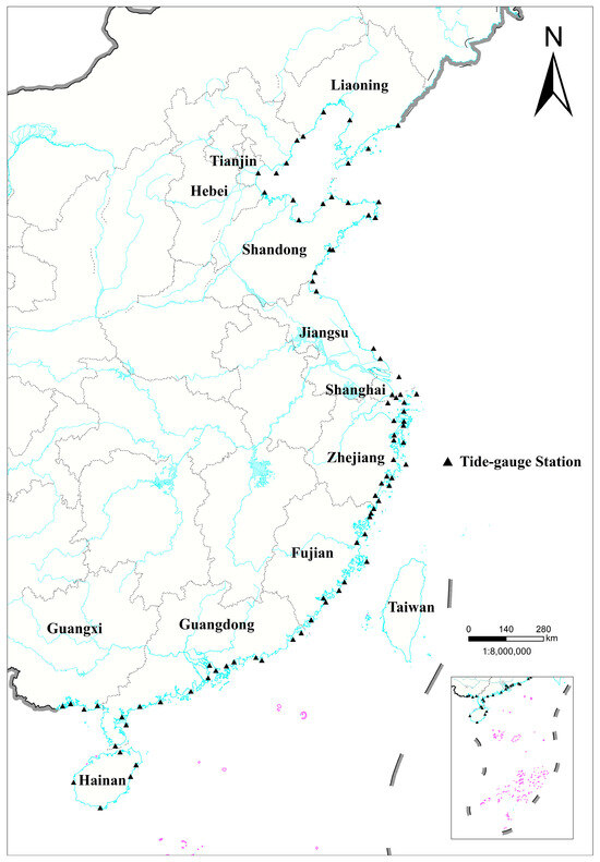
Figure 1.
Distribution of tide-gauge stations along coast of China.
Water warning levels at each station were also collected. The water warning level indicates the potential value of the water level that may cause a tidal disaster along the coast of the protection zone. The water warning level forms the basis for storm-surge forecasting, and plays an important role in prewarning and decision-making for a storm surge disaster response. An area with an exceeded water level needs to enter a state of alert or disaster relief. A quantitative method for determining the water warning level was recommended by the authorities, and detailed information can be found in Liu et al. [27]. The total water level minus the water warning level equals the exceeded water warning level. The distribution of four-color water warning levels along the coast of China is shown in Figure 2.
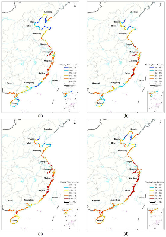
Figure 2.
Spatial distribution map of four-color water warning levels: (a) Blue; (b) Yellow; (c) Orange; (d) Red.
Further, the population and economic distribution data for 219 coastal counties in China was collected, which was used to calculate the vulnerability level for each coastal county. These data were provided by the Office of the Leading Group for the first National Comprehensive Survey of Natural Disaster Risks.
3. Methods
The storm surge hazard index was constructed to perform hazard assessments for each coastal county based on the observational data. A comprehensive consideration of the storm surge hazard and vulnerability level in each coastal county, i.e., a risk matrix, was used to assess the population and economic risk distribution in coastal areas.
3.1. Hazard Assessment
The height of the storm surge and high-water level are important factors determining the severity of coastal flood events. In this study, storm surge height and exceeded water warning level were selected as the key indicators for assessing storm surge hazard, and a storm surge hazard index was established based on these two indicators. As stipulated in the National Emergency Response Plan for Marine Disasters issued by the State Oceanic Administration of China, the storm surge height was divided into five levels (graded I–V, corresponding to particularly severe, severe, relatively severe, mild, and low) according to its natural intensity (Table 2). Additionally, the exceeded water warning levels were divided according to their alert level in storm surge forecasting and warning (Table 3) as grades I–IV, corresponding to particularly severe, severe, relatively severe, and mild, with designated color codes of red, orange, yellow, and blue, respectively.
Table 2.
Classification of storm surge heights (unit cm).
Table 3.
Classification of exceeded water warning levels.
In order to emphasize the gravity of grade I and grade II storm surge events, the concept of the storm surge hazard index was put forward. This index is centered entirely on the inherent hazard characteristics of storm surges. It does not factor in elements such as human casualties, property damage, and other secondary disasters that may occur as a result of a storm surge. Each hazard grade was assigned a different weight to highlight the importance of the hazard intensity of storm surge events above Level III. The storm surge hazard index was calculated by multiplying the number of occurrences of each grade of the hazard intensity indicator by the weight of the hazard grade. In other words, the storm surge hazard index was determined by how much a high tide level exceeded the local water warning level in a single storm surge event, and the frequency of these extreme storm surge heights.
The National Marine Environmental Forecasting Center of China and the National Marine Hazard Mitigation of China analyzed the storm surge hazards for coastal tide-gauge stations based on observational data from the years 1949 to 2015 referring to expert experience, and established the weight coefficient of storm surge heights and exceeded water warning levels to assess the hazard levels of storm surge events, which formed China’s Marine Industry Standard [28,29]. The correlation between exceeded water warning levels and the loss caused by a storm surge disaster is higher than that of storm surge height. We provided 40% and 60% weight to the surge height and exceeded water warning levels in this study according to China’s Marine Industry Standard [28], respectively.
Building upon these classifications, we defined a storm surge hazard index using Formula (1) and categorized it into four levels (Table 4). The equation for calculating the storm surge hazard index for a single station, , is as follows:
where is the storm surge height index, is an index of the exceeded water warning level, and is the number of years of the statistical data. The of a single station was calculated as follows:
where , , , , and are the number of times a single station experienced storm surge heights of grade I, II, III, IV, and V, respectively. The Hg of a single station was calculated as follows:
where , , , and are the number of times a single station experienced storm surges that exceeded the red, orange, yellow, and blue water warning levels, respectively.
Table 4.
Classification of storm surge hazard levels.
3.2. Vulnerability Assessment
The risk of storm surge disasters predominantly hinges on the interaction between the hazard posed by the storm surge and the vulnerability of the society that is at risk. When it comes to assessing vulnerability to storm surges, population distribution and economic activities are among the primary aspects to be considered. Although the disaster prevention capability of a coastal county is a significant factor influencing vulnerability, due to the fact that obtaining reliable data regarding this aspect is not straightforward and the local water warning level has already incorporated such a capability, the storm surge disaster risk assessment conducted in this study primarily relies on the vulnerability of the population and the economy. We considered a quantile-based grading method to categorize economic and population vulnerability into four levels. We have presented the grading criteria for the same as shown in Table 5. Briefly, according to the quantile-based grading method, we classified 219 counties into four categories, and the proportion of each category accounted for 25%, which indicated that each category has 55 counties (one of them contains 54).
Table 5.
Vulnerability level grading criteria for population and economy.
3.3. Risk Assessment
Our assessment of storm surge vulnerability incorporated coastal population and economic distribution data at the county level, with hazard levels also assessed at the county level. The storm surge risk at county level was assessed according to the hazard level and the economic and population vulnerability:
where and represents the storm surge risk, hazard, and vulnerability, respectively. Hazard (H) and vulnerability (V) levels were divided into four categories, ranging from high (I) to low (IV). Risk levels were also similarly categorized from high (I) to low (IV). The Equation (4) represents the classification matrix but not mathematical multiplication in assessing the risk level. The correlation between risk, hazard, and vulnerability levels for storm surge disasters is shown in Table 6, following the operational guidelines for storm surge risk assessment in China. The horizontal values represent vulnerability levels, and the vertical values represent hazard levels. The risk level can be calculated from Table 6 if the hazard and vulnerability levels are obtained.
Table 6.
Hazard and vulnerability corresponding to risk level relationship.
4. Results
In this section, we analyzed the storm surge hazard and risk distribution in the coastal areas of China. Our analysis presented distinct patterns characteristics of storm surge risk in the coastal areas of China, and the causes of storm surge disaster-related economic and population risk distribution patterns in coastal areas are revealed.
4.1. Storm Surge Hazard
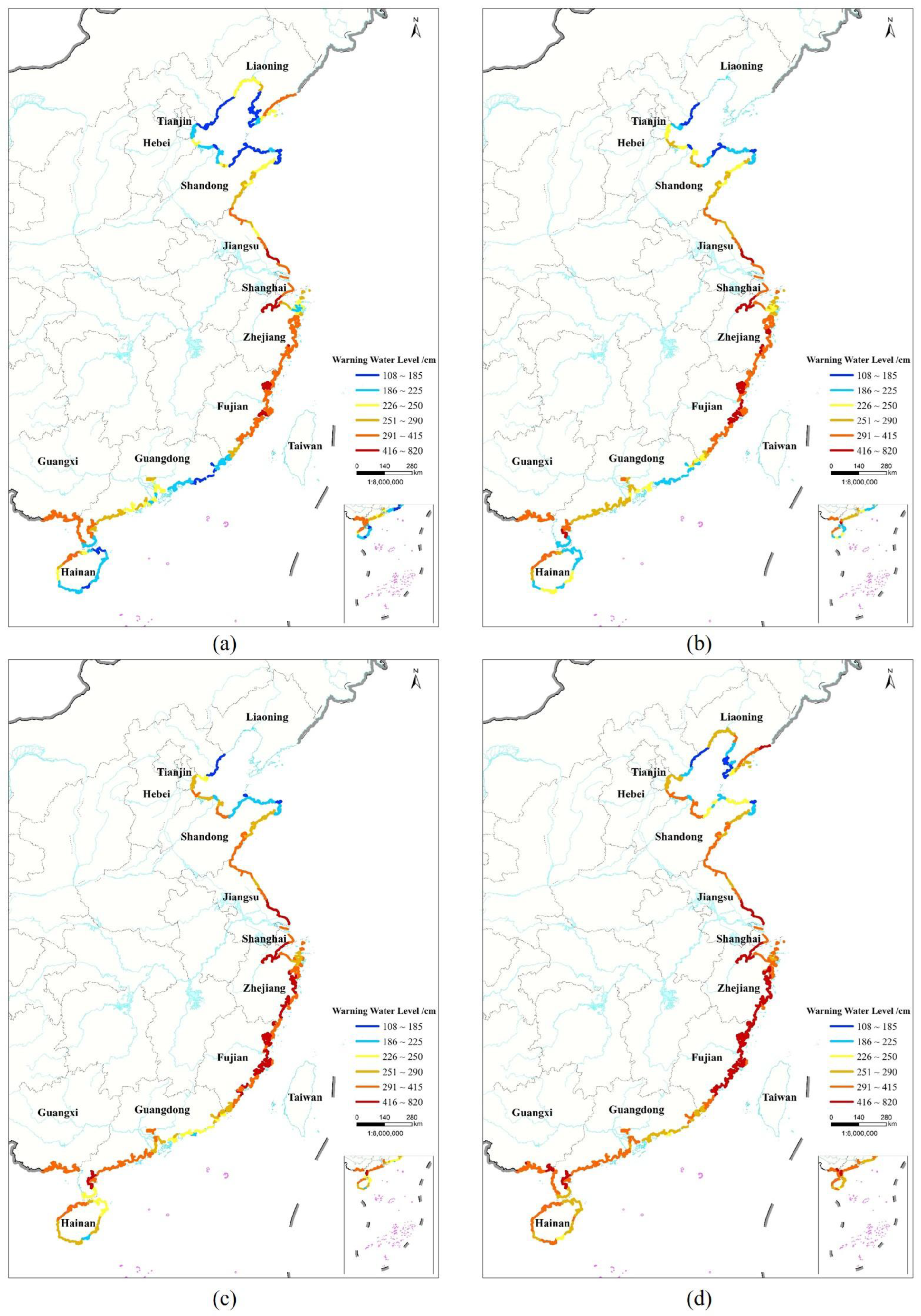
The storm surge hazard varies from north to south in the China coast (Figure 3). The results showed a low level of storm surge hazard for the northernmost and southernmost coastal areas but a high level for the central coastal area. Among a total of 219 coastal counties of China, the storm surge hazard level is I, II, III, and IV for 63, 67, 64, and 25 counties, respectively. Counties with high storm surge hazards (I and II) account for more than 59% of all coastal counties, indicating the urgent need for designing and implementing measures to prevent and mitigate such events in these areas. Very high hazard areas (I) are mainly affected by storm surges caused by extratropical cyclones in the north and typhoons in the south with high frequency and intensity. More specifically, level I areas, located along the bottom coast of Bohai Bay and the west coast of Laizhou Bay, are more affected by extratropical storm surges; level I areas, located along the south coast of Hangzhou Bay, the coast from southern Zhejiang to northern Fujian, east of the Leizhou Peninsula, and in the Pearl River Estuary, have a high frequency of typhoon landings, are prone to typhoon storm surges, and are mainly distributed in estuarine areas. We compared the hazards assessment results with those of previous studies, including Fang et al. [25], Shi et al. [26] and Fu et al. [9]. It can be found that the I-level areas located in this study were similar to previous studies.

Figure 3.
Distribution of storm surge hazards in coastal counties of China.
4.2. Storm Surge Vulnerability and Risk
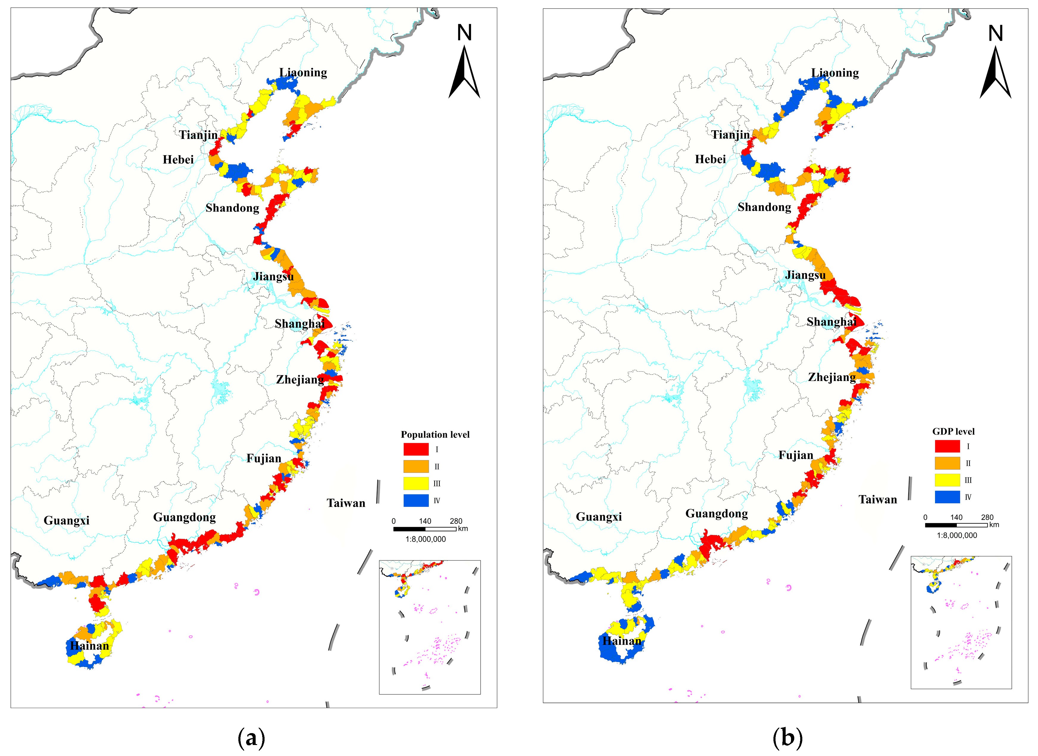
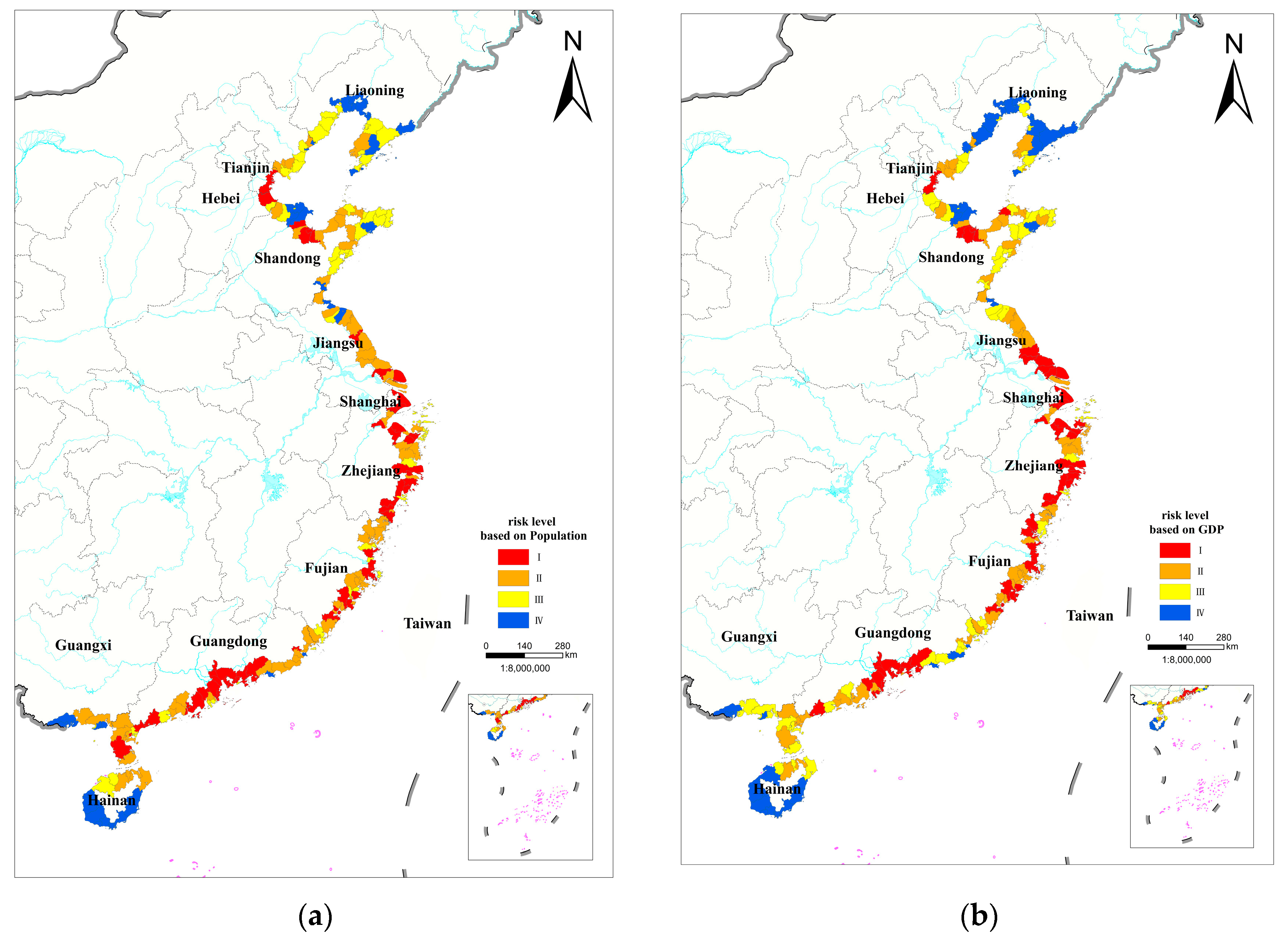
Relevant storm surge vulnerability levels were calculated based on the population and GDP distribution (Figure 4). The risk level was evaluated by combining the vulnerability and hazard results for each coastal county. The statistical results are shown in Figure 4. Among the 219 coastal counties in China, areas of high risk in terms of the effects of such events on the population and the economy accounted for 25.1% and 27.4%, respectively.

Figure 4.
Storm surge vulnerability of coastal counties in China according to population (a) and GDP (b).
The disaster risk of storm surges presents distinct spatial distribution characteristics along the China coast. Areas with high population risk are located at the bottom of Bohai Bay, bottom of Laizhou Bay, in Hangzhou Bay, along the coastline from southern Zhejiang to northern Fujian, in the Pearl River Estuary, and in the central part of the Leizhou Peninsula (Figure 5a). The population density is high in these coastal regions and a population vulnerability level of I (Figure 4a) was indicated in addition to a high storm surge hazard level. Areas with the highest economic risk exhibit similar spatial distribution with that of the highest population risk (Figure 5b), but include the south coast of Jiangsu Province and exclude the Leizhou Peninsula.
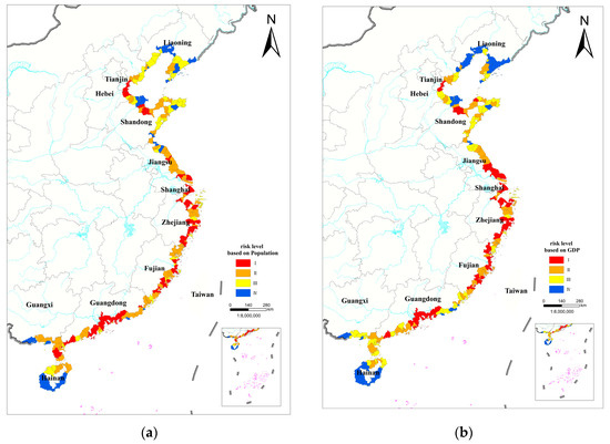
Figure 5.
Storm surge risk for coastal counties according to population (a) and GDP (b).
The south coast of Jiangsu Province, which falls within the Yangtze River Delta, has a hazard level of II. Because of its robust economic development, it has an economic vulnerability level of I (Figure 4b). However, its population vulnerability level is II, resulting in an economic risk level of I and a population risk level of II. Although the Leizhou Peninsula is an area of high population risk, its economic risk is comparatively lower owing to the relatively underdeveloped economy of the peninsula. Moreover, the peninsula’s distinctive geographic positioning renders it highly vulnerable to storm surge impacts, earning it a Level I storm surge risk designation. Although the population density in this area is high, its economic development level is relatively low. Consequently, the population risk level is I, whereas the economic risk level is II. Moreover, although some regions have a low storm surge hazard, the risk for population exposure is high owing to the high population density along the coastline, e.g., in Dalian in the eastern part of the Liaodong Peninsula, and Qingdao in the southeastern part of the Shandong Peninsula.
5. Discussion
This research involved a national storm surge risk assessment considering the exposure of economies and population, and provided the storm surge risk distribution from macroscopic aspects along the China coast, represents advancement in the assessment of county-level storm surge risk and zonation efforts in China. In addition, we compared the high risk distribution areas with a previous study conducted by Shi [1], named “Spatial-temporal distribution of storm surge damage in the coastal areas of China”, and we found that the Level I distribution areas in our research are all located in the provinces that suffer the most significant casualties and direct economic losses.
The results can serve as a basis for disaster risk management, offering valuable scientific information for mitigation measures in coastal regions. In this study, we employed two key indicators, namely storm surge height and exceeded water warning levels, for constructing a storm surge hazard index and assessing the distribution of such hazards across the coastal regions of China. Further, we assessed the storm surge vulnerability using population and economic distribution data at the county level. Subsequently, we integrated hazard and vulnerability distributions to generate a storm surge risk map for coastal areas at the county level. Hazard and vulnerability assessments of people and areas exposed to risk are crucial elements of a storm surge risk assessment. Nevertheless, due to constraints in data availability, the impacts of areas that are potentially subject to inundation and the losses incurred from storm surges have not been taken into account.
Rapid socioeconomic growth in the coastal regions of China has led to substantial changes in storm surge protective measures, population density, economic development, and urban planning. Therefore, current methods for assessing storm surge risk cannot fully account for the influence of such dynamic changes in socioeconomic factors on risk outcomes. Coastal regions are facing an increasing compounded risk of coastal flooding and rising sea levels that are driven by climate factors and non-climate factors such as population and economic growth, as well as changes in land use and land cover [30,31]. Therefore, adjusting economic development strategies and population migration policies should be a focal point of future comprehensive disaster risk management and sustainable development.
Moreover, it is essential to endeavor to analyze and quantify the correlations among additional relevant factors and the risk of storm surges in future research. This will contribute to enhancing the effectiveness of disaster management and minimizing the damage associated with disasters. Such factors include different sea level rise scenarios, population densities, and per capita GDP. Furthermore, to meet the demands of storm surge risk management and control in coastal areas, it is essential to elucidate the dynamic evolution results of storm surge risk considering the spatiotemporal dynamic changes of disaster factors and exposures, and explore a combined approach that integrates quantitative analysis with dynamic simulations to conduct high-resolution risk assessments of local areas.
6. Conclusions
The main findings of this study are as follows. The hazard distribution of storm surges in China varies from north to south, with the areas of highest hazard located along the bottom coast of Bohai Bay, west coast of Laizhou Bay, south coast of Hangzhou Bay, the Pearl River Delta, and the east coast of the Leizhou Peninsula. We ascribed the variability in storm surge risk to differences in the GDP, population, and storm surge hazard among the coastal counties. The risk in China exhibits significant spatial variations, with areas of high risk in terms of potential effects based on population and economic levels accounting for 25.1% and 27.4% of all coastal counties, respectively. Areas of high population risk are concentrated at the bottom of Bohai and Laizhou Bays, in the southern regions of Hangzhou Bay, southern coastal areas extending from southern Zhejiang to northern Fujian, the Pearl River Delta, and the central part of the Leizhou Peninsula. This pattern is similar for areas of high economic risk, with the exception of the south coast in Jiangsu Province.
Through this study, we found that the population and economic exposure risk of storm surge disasters in China presents distinct spatial distribution characteristics. Determining the spatial distribution of storm surge risks enabled us to provide local governments with essential information on disaster hotspots that can be employed to design and enhance protective measures against such events in specific regions. Our study also presents some limitations. A county-level storm surge risk assessment was performed for a coastal country, and large-scale inundation simulations along the coast from north to south were not performed. A more refined quantitative storm surge risk assessment combined with numerical simulation inundation results will be conducted in the future, not merely at the county level, but also with the use of high-precision population and economic grid data.
Author Contributions
X.S.: Data curation, Writing—original draft. Y.Z. (Yande Zhang): Supervision, Writing—review & editing. S.L.: Conceptualization, Methodology, Writing—review & editing. L.Y.: Data curation, review & editing. L.Y.: Writing—original draft. Y.Z. (Yao Zhang): Data curation, review & editing. N.J. and Z.T.: Formal analysis. All authors have read and agreed to the published version of the manuscript.
Funding
This work was funded by the National Key Research and Development Program of China (2023YFC3008505) and the National Natural Science Foundation of China (41701596).
Data Availability Statement
The datasets used and analyzed during the current study are available from the corresponding author on reasonable request.
Conflicts of Interest
The authors declare no conflict of interest.
References
- Shi, X.; Liu, S.; Yang, S.; Liu, Q.; Tan, J.; Guo, Z. Spatial-temporal distribution of storm surge damage in the coastal area of China. Nat. Hazards 2015, 79, 237–247. [Google Scholar] [CrossRef]
- Shi, X.W.; Qiu, J.F.; Chen, B.R.; Zhang, X.J.; Guo, H.S.; Wang, J.; Bei, Z.Y. Storm Surge Risk Assessment Method for a Coastal County in China: Case study of Jinshan District, Shanghai. Stoch. Environ. Res. Risk Assess. 2020, 34, 627–640. [Google Scholar] [CrossRef]
- Vincenzo, J.L.; Patton, S.K.; Lefler, L.L.; Mcelfish, P.A.; Wei, J.; Curran, G.M. A qualitative study of older adults’ facilitators, barriers, and cues to action to engage in falls prevention using health belief model constructs. Arch. Gerontol. Geriatr. 2022, 99, 104610. [Google Scholar] [CrossRef] [PubMed]
- Fang, J.; Liu, W.; Yang, S.; Brown, S.; Nicholls, R.J.; Hinkel, J.; Shi, X.; Shi, P. Spatial-temporal changes of coastal and Marine Disasters Risks and impacts in Mainland China. Ocean Coast. Manag. 2017, 139, 125–140. [Google Scholar] [CrossRef]
- Gori, A.; Lin, N.; Xi, D.; Emanuel, K. Tropical cyclone climatology change greatly exacerbates US extreme rainfall–surge hazard. Nat. Clim. Change 2022, 12, 171–178. [Google Scholar] [CrossRef]
- Xu, H.Q.; Ragno, E.; Tan, J.K.; Antonini, A.; Bricker, J.D.; Jonkman, S.N.; Liu, Q.; Wang, J. Perspectives on Compound Flooding in Chinese Estuary Regions. Int. J. Disaster Risk Sci. 2023, 14, 269–279. [Google Scholar] [CrossRef]
- Yang, H.T.; Tian, S.Z.; Ye, L.; Xu, F.X. Chinese Marine Disasters Four Decades Compilation; China Ocean Press: Beijing, China, 1991; pp. 4–7. [Google Scholar]
- Guo, T.J.; Li, G.S. Study on methods to identify the impact factors of economic losses due to typhoon storm surge based on confirmatory factor analysis. Nat. Hazards 2020, 100, 515–534. [Google Scholar] [CrossRef]
- Fu, X.; Hou, J.M.; Liu, Q.X.; Li, M.J.; Liang, S.D. Evaluation of Storm Surge Hazard Along the Mainland Coast of China. Nat. Hazards 2022, preprints. [Google Scholar] [CrossRef]
- Yu, F.J.; Dong, J.X.; Ye, L. Historical Data Collection of Storm Surge Disasters in China 1949–2009; China Ocean Press: Beijing, China, 2015. (In Chinese) [Google Scholar]
- Begmohammadi, A.; Blackshaw, C.Y.; Lin, N.; Gori, A.; Wallace, E.; Emanuel, K.; Donnelly, J.P. Integrating climatological-hydrodynamic modeling and paleohurricane records to assess Storm surge risk. J. Geophys. Res. Ocean. 2024, 129, e2023JC020354. [Google Scholar] [CrossRef]
- Cardona, O.D.; van Aalst, M.K.; Birkmann, J.; Fordham, M.; McGregor, G.; Perez, R.; Pulwarty, R.S.; Schipper, E.L.F.; Sinh, B.T. Determinants of risk: Exposure and vulnerability. In Managing the Risks of Extreme Events and Disasters to Advance Climate Change Adaptation; Special Report of the Intergovernmental Panel on Climate Change; Cambridge University Press: Cambridge, UK, 2012; pp. 65–108. [Google Scholar] [CrossRef]
- Liu, Q.; Yang, S. Review of Different Methodologies and Risk Assessment Models in Storm Surge Disaster Management. In Advances in Civil and Industrial Engineering IV: Selected, Proceedings of the 4th International Conference on Civil Engineering, Architecture and Building Materials (CEABM), Haikou, China, 24–25 May 2014; Trans Tech Publications: Wollerau, Switzerland, 2014; pp. 2592–2598. [Google Scholar]
- Shi, X.W.; Gao, T.; Tan, J.; Guo, Z.X. Research on Occurrence Frequency of Storm Surge Disaster Distribution in the Coastal Areas of China. J. Catastrophol. 2018, 33, 49–52. (In Chinese) [Google Scholar]
- Rashid, M.M.; Moftakhari, H.; Moradkhani, H. Stochastic simulation of storm surge extremes along the contiguous United States coastlines using the max-stable process. Commun. Earth Environ. 2024, 5, 39. [Google Scholar] [CrossRef]
- Wang, K.; Yang, Y.; Reniers, G.; Huang, Q. A study into the Spatiotemporal Distribution of Typhoon Storm Surge Disasters in China. Nat. Hazards 2021, 108, 1237–1256. [Google Scholar] [CrossRef]
- Seenath, A.; Wilson, M.; Miller, K. Hydrodynamic versus GIS modelling for coastal flood vulnerability assessment: Which is better for guiding coastal management? Ocean Coast. Manag. 2016, 120, 99–109. [Google Scholar] [CrossRef]
- Lin, N.; Emanuel, K.A.; Smith, J.A.; Vanmarcke, E. Risk assessment of Hurricane Storm Surge for New York City. J. Geophys. Res. 2010, 115, D18121. [Google Scholar] [CrossRef]
- Shi, X.W.; Lv, Y.F.; Dong, D.B.; Jia, N.; Ge, J.; Yin, J. Quantitative assessment of building risks and loss ratios caused by storm surge disasters: Acase study of Xiamen, China. Appl. Ocean. Res. 2024, 145, 103934. [Google Scholar] [CrossRef]
- Li, T.; Fu, C.F.; Wang, F.D.; Dong, J.X. Storm surge disaster risk assessment and zoning, taking Cangnan County for instance. Procedia IUTAM 2017, 25, 92–99. [Google Scholar] [CrossRef]
- Liu, Q.; Ruan, C.; Zhong, S.; Li, J.; Yin, Z.; Lian, X. Risk Assessment of Storm Surge Disaster based on Numerical Models and Remote Sensing. Int. J. Appl. Earth Obs. Geoinf. 2018, 68, 20–30. [Google Scholar] [CrossRef]
- Liu, Y.M.; Lu, C.; Yang, X.M.; Wang, Z.H.; Liu, B. Fine-Scale Coastal Storm Surge Disaster Vulnerability and Risk Assessment Model: A Case Study of Laizhou Bay, China. Remote Sens. 2020, 12, 1301. [Google Scholar] [CrossRef]
- Wang, S.; Mu, L.; Qi, M.N.; Yu, Z.K.; Yao, Z.F.; Zhao, E.J. Quantitative Risk Assessment of Storm Surge Using GIS techniques and Open Data: A Case Study of Daya Bay Zone, China. J. Environ. Manag. 2021, 289, 112514. [Google Scholar] [CrossRef]
- Zhang, S.; Zhang, J.; Li, X.; Du, X.; Zhao, T.; Hou, Q.; Jin, X. Quantitative Risk Assessment of Typhoon Storm Surge for Multi-Risk Sources. J. Environ. Manag. 2023, 327, 116860. [Google Scholar] [CrossRef]
- Fang, W.H.; Wang, J.A.; Shi, P.J. Integrated Risk Governance-Datebase, Risk Map and Network Platform; Science Press: Beijing, China, 2011. (In Chinese) [Google Scholar]
- Shi, X.W.; Han, Z.Q.; Fang, J.Y.; Tan, J.; Guo, Z.; Sun, Z. Assessment and Zonation of Storm Surge Hazards in the Coastal Areas of China. Nat. Hazards 2020, 100, 39–48. [Google Scholar] [CrossRef]
- Liu, S.; Shi, X.; Liu, Q.; Tan, J.; Sun, Y.; Liu, Q.; Guo, H. Warning Water Level Determination and its Spatial Distribution in Coastal Areas of China. Nat. Hazards Earth Syst. Sci. 2023, 23, 127–138. [Google Scholar] [CrossRef]
- Ministry of Natural Resources of China. Technical Directives for Risk Assessment and zoning of Marine Disaster-Part 1: Storm Surge: HY/T 0273–2019; National Standards Press of China: Beijing, China, 2019. (In Chinese) [Google Scholar]
- Yu, F.J.; Dong, J.X.; Li, T. Assessment of the Impact of Storm Surge on Coastal Areas of China; China Ocean Press: Beijing, China, 2015. [Google Scholar]
- IPCC. Climate Change 2021: The Physical Science Basis; Contribution of working group I to the Sixth Assessment Report of the IPCC; Cambridge University Press: Cambridge, UK; New York, NY, USA, 2021. [Google Scholar]
- Ministry of Natural Resources of China. China Sea Level Bulletin. 2022. Available online: http://gi.mnr.gov.cn/202304/t20230412_2781114.html (accessed on 29 June 2023).


Disclaimer/Publisher’s Note: The statements, opinions and data contained in all publications are solely those of the individual author(s) and contributor(s) and not of MDPI and/or the editor(s). MDPI and/or the editor(s) disclaim responsibility for any injury to people or property resulting from any ideas, methods, instructions or products referred to in the content. |
© 2025 by the authors. Licensee MDPI, Basel, Switzerland. This article is an open access article distributed under the terms and conditions of the Creative Commons Attribution (CC BY) license (https://creativecommons.org/licenses/by/4.0/).