Identification of Floating Green Tide in High-Turbidity Water from Sentinel-2 MSI Images Employing NDVI and CIE Hue Angle Thresholds
Abstract
1. Introduction
2. Data Source and Data Preprocessing
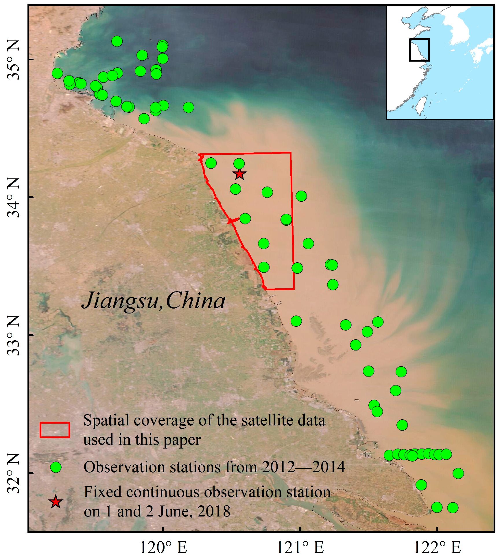
2.1. In Situ Measured Data
2.2. Satellite Data
2.3. Calculation of the NDVI
2.4. Calculation of the CIE Hue Angle
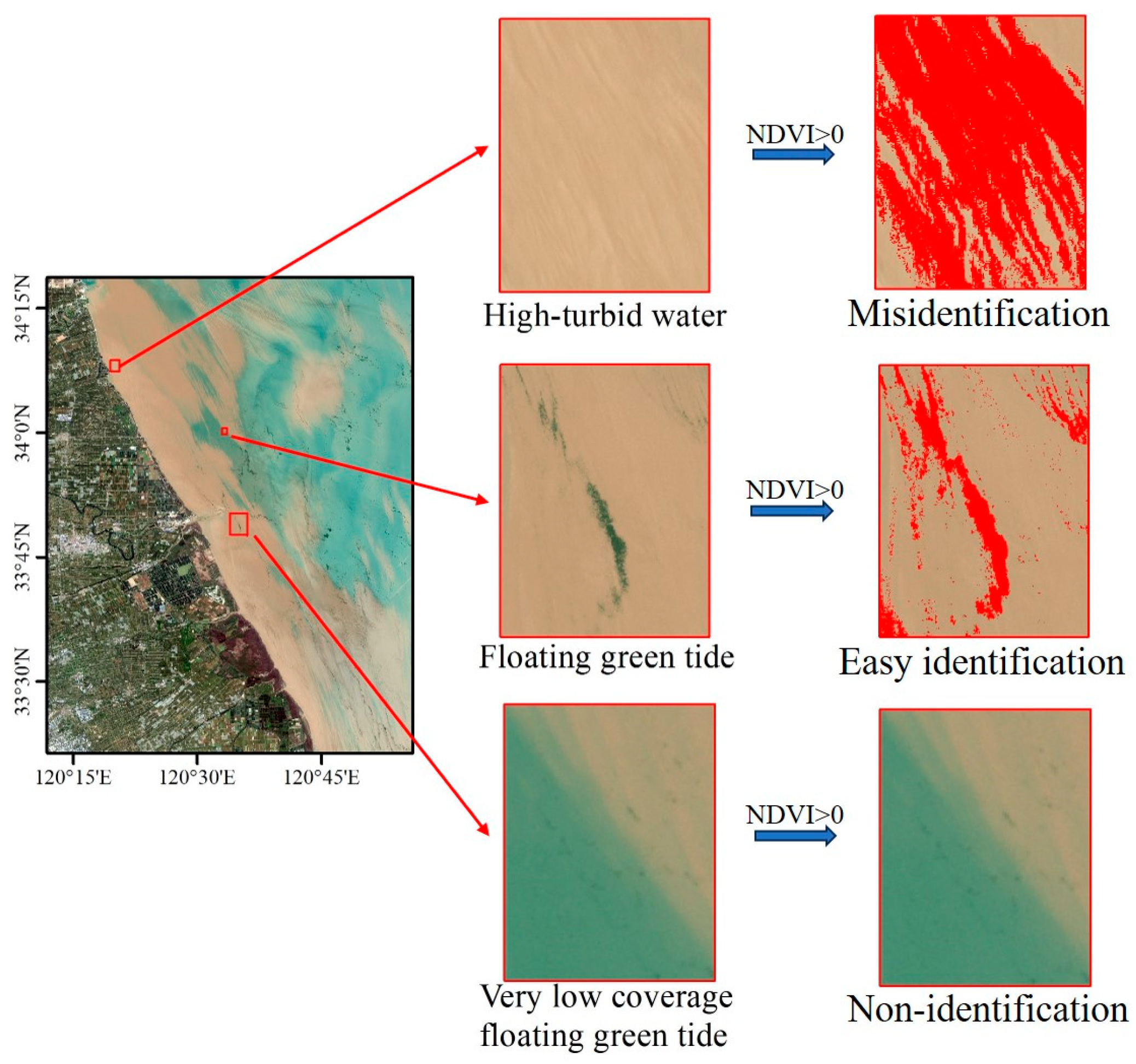
3. Mechanistic Analysis of Identification Method
3.1. Difference in Characteristic Spectrum between Floating Green Tide and HTW
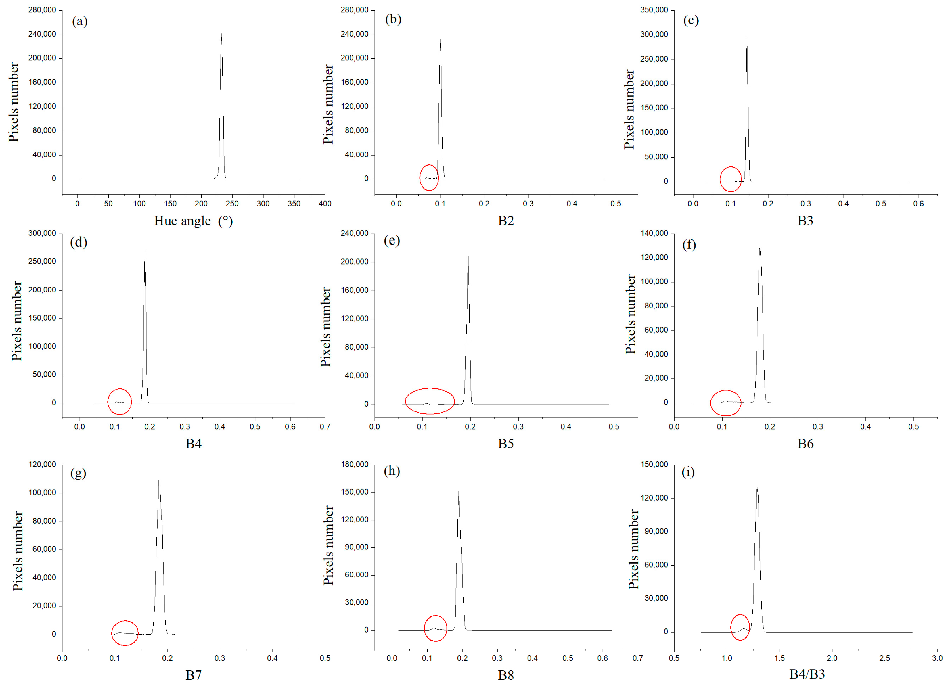
3.2. Different in Hue Angle between Floating Green Tide and Turbid Water
4. Determination of the NDVI and CIE Hue Angle Thresholds
4.1. NDVI Threshold
4.2. CIE Hue Angle Threshold
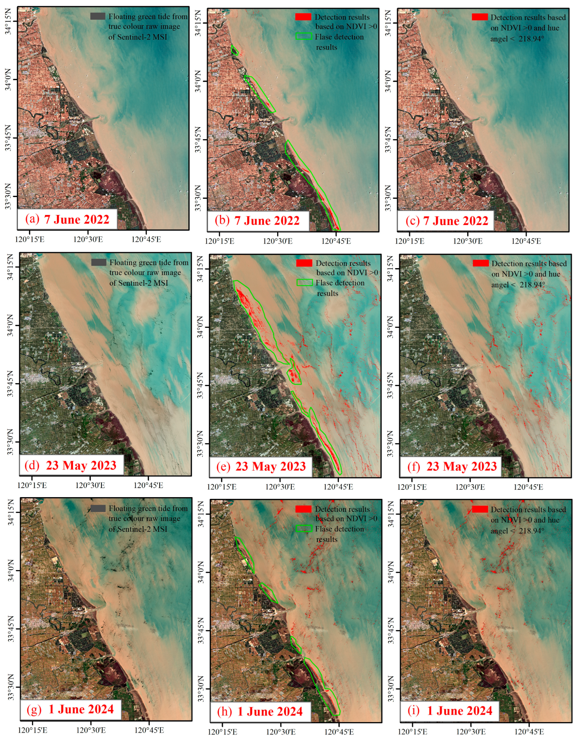
5. Demonstration of Method
- The identification error rate—the ratio of the number of HTW pixels misidentified as floating green tide to the number of floating green tide pixels;
- The loss rate—the ratio of the number of floating green tide pixels removed owing to a constantly increased NDVI threshold to the number of floating green tide pixels;
- The total misidentification rate—to the sum of the identification error rate and the loss rate.
6. Discussion
6.1. Selection of Identification Factors
6.2. Suitability of Other Satellite Data Sources
7. Conclusions
Author Contributions
Funding
Institutional Review Board Statement
Informed Consent Statement
Data Availability Statement
Conflicts of Interest
References
- Wang, X.H.; Li, L.; Bao, X.; Zhao, L.D. Economic cost of an algae bloom cleanup in China’s 2008 Olympic sailing venue. Eos Trans. Am. Geophys. Union. 2009, 90, 238–239. [Google Scholar] [CrossRef]
- Hu, C.; Cannizzaro, J.; Carder, K.L.; Muller-Karger, F.E.; Hardy, R. Remote detection of Trichodesmium blooms in optically complex coastal waters: Examples with MODIS full-spectral data. Remote Sens. Environ. 2010, 114, 2048–2058. [Google Scholar] [CrossRef]
- Hu, C.M.; He, M.X. Origin and offshore extent of floating algae in Olympic sailing area. Eos Trans. Am. Geophys. Union. 2008, 89, 302–303. [Google Scholar] [CrossRef]
- Hu, L.B.; Hu, C.M.; He, M.X. Remote estimation of biomass of Ulva prolifera macroalgae in the Yellow Sea. Remote Sens. Environ. 2017, 192, 217–227. [Google Scholar] [CrossRef]
- Cui, T.W.; Liang, X.J.; Gong, J.L.; Tong, C.; Xiao, Y.; Liu, R.; Zhang, X.; Zhang, J. Assessing and refining the satellite-derived massive green macro-algal coverage in the Yellow Sea with high resolution images. ISPRS J. Photogramm. Remote Sens. 2018, 144, 315–324. [Google Scholar] [CrossRef]
- Sun, D.Y.; Chen, Y.; Wang, S.Q.; Zhang, H.; Qiu, Z.; Mao, Z.; He, Y. Using Landsat 8 OLI data to differentiate Sargassum and Ulva prolifera blooms in the South Yellow Sea. Int. J. Appl. Earth Obs. Geoinf. 2021, 98, 102302. [Google Scholar] [CrossRef]
- Wang, X.H.; Xing, Q.G.; An, D.Y.; Meng, L.; Zheng, X.; Jiang, B.; Liu, H. Effects of spatial resolution on the satellite observation of floating macroalgae blooms. Water 2021, 13, 1761. [Google Scholar] [CrossRef]
- Zheng, L.; Wu, M.Q.; Cui, Y.T.; Tian, L.; Yang, P.; Zhao, L.; Xue, M.; Liu, J. What causes the great green tide disaster in the South Yellow Sea of China in 2021. Ecol. Indic. 2022, 140, 108988. [Google Scholar] [CrossRef]
- Keesing, J.K.; Liu, D.; Fearns, P.; Garcia, R. Inter-and intra-annual patterns of Ulva prolifera green tides in the Yellow Sea during 2007–2009, their origin and relationship to the expansion of coastal seaweed aquaculture in China. Mar. Pollut. Bull. 2011, 62, 1169–1182. [Google Scholar] [CrossRef]
- Xing, Q.G.; Tosi, L.; Braga, F.; Gao, X.; Gao, M. Interpreting the progressive eutrophication behind the world’s largest macroalgal blooms with water quality and ocean color data. Nat. Hazards 2015, 78, 7–21. [Google Scholar] [CrossRef]
- Sun, X.; Wu, M.Q.; Xing, Q.G.; Song, X.; Zhao, D.; Han, Q.; Zhang, G. Spatio-temporal patterns of Ulva prolifera blooms and the corresponding influence on chlorophyll-a concentration in the Southern Yellow Sea, China. Sci. Total Environ. 2018, 640, 807–820. [Google Scholar] [CrossRef] [PubMed]
- Li, D.X.; Gao, Z.Q.; Wang, Z.C. Analysis of the reasons for the outbreak of Yellow Sea green tide in 2021 based on long-term multi-source data. Mar. Environ. Res. 2022, 178, 105649. [Google Scholar] [CrossRef] [PubMed]
- Zhang, B.W.; Guo, J.Z.; Li, Z.W.; Cheng, Y.; Zhao, Y.; Boota, M.W.; Zhang, Y.; Feng, L. Identifying the spatio-temporal variations of Ulva prolifera disasters in all life cycle. J. Water Clim. Chang. 2021, 13, 629–644. [Google Scholar] [CrossRef]
- Xu, F.X.; Gao, Z.Q.; Shang, W.T.; Jiang, X.; Zheng, X.; Ning, J.; Song, D. Validation of MODIS-based monitoring for a green tide in the Yellow Sea with the aid of unmanned aerial vehicle. J. Appl. Remote Sens. 2017, 11, 012007. [Google Scholar] [CrossRef]
- Xing, Q.; Wu, L.; Tian, L.; Cui, T.; Li, L.; Kong, F.; Gao, X.; Wu, M. Remote sensing of early-stage green tide in the Yellow Sea for floating-macroalgae collecting campaign. Mar. Pollut. Bull. 2018, 133, 150–156. [Google Scholar] [CrossRef] [PubMed]
- Hu, L.; Zeng, K.; Hu, C.; He, M.-X. On the remote estimation of Ulva prolifera areal coverage and biomass. Remote Sens. Environ. 2019, 223, 194–207. [Google Scholar] [CrossRef]
- Yuan, C.; Xiao, J.; Zhang, X.; Zhou, J.; Wang, Z. A new assessment of the algal biomass of green tide in the Yellow Sea. Mar. Pollut. Bull. 2022, 174, 113253. [Google Scholar] [CrossRef] [PubMed]
- Son, Y.B.; Min, J.-E.; Ryu, J.-H. Detecting massive green algae (Ulva prolifera) blooms in the Yellow Sea and East China Sea using geostationary ocean color imager (GOCI) data. Ocean Sci. J. 2012, 47, 359–375. [Google Scholar] [CrossRef]
- Xiao, Y.F.; Zhang, J.; Cui, T.W.; Gong, J.; Liu, R.; Chen, X.; Liang, X. Remote sensing estimation of the biomass of floating Ulva prolifera and analysis of the main factors driving the interannual variability of the biomass in the Yellow Sea. Mar. Pollut. Bull. 2019, 140, 330–340. [Google Scholar] [CrossRef]
- Zheng, H.Y.; Liu, Z.; Chen, B.; Xu, H. Quantitative Ulva prolifera bloom monitoring based on multi-source satellite ocean color remote sensing data. Appl. Ecol. Environ. Res. 2020, 18, 4897–4913. [Google Scholar] [CrossRef]
- Hu, C.M. A novel ocean color index to detect floating algae in the global oceans. Remote Sens. Environ. 2009, 113, 2118–2129. [Google Scholar] [CrossRef]
- Hu, C.M.; Li, D.O.; Chen, C.S.; Ge, J.; Muller-Karger, F.E.; Liu, J.; Yu, F.; He, M.-X. On the recurrent Ulva prolifera blooms in the Yellow Sea and East China Sea. J. Geophys. Res. Ocean. 2010, 115, C005561. [Google Scholar] [CrossRef]
- Qi, L.; Hu, C.M.; Xing, Q.G.; Shang, S. Long-term trend of Ulva prolifera blooms in the western Yellow Sea. Harmful Algae 2016, 58, 35–44. [Google Scholar] [CrossRef]
- Xing, Q.G.; Hu, C.M. Mapping macroalgal blooms in the Yellow Sea and East China Sea using HJ-1 and Landsat data: Application of a virtual baseline reflectance height technique. Remote Sens. Environ. 2016, 178, 113–126. [Google Scholar] [CrossRef]
- Zhang, H.L.; Yuan, Y.B.; Xu, Y.J.; Shen, X.; Sun, D.; Qiu, Z.; Wang, S.; He, Y. Remote sensing method for detecting green tide using HJ-CCD top-of-atmosphere reflectance. Int. J. Appl. Earth Obs. Geoinf. 2021, 102, 102371. [Google Scholar] [CrossRef]
- Qi, L.; Hu, C.; Barnes, B.B.; Lapointe, B.E.; Chen, Y.; Xie, Y.; Wang, M. Climate and anthropogenic controls of seaweed expansions in the East China Sea and Yellow Sea. Geophys. Res. Lett. 2022, 49, e2022GL098185. [Google Scholar] [CrossRef]
- Alawadi, F. Detection of surface algal blooms using the newly developed algorithm surface algal bloom index (SABI). In Proceedings of the Remote Sensing of the Ocean, Sea Ice, and Large Water Regions 2010, Toulouse, France, 22–23 September 2010; Volume 7825, pp. 45–58. [Google Scholar] [CrossRef]
- Hu, C.; Qi, L.; Hu, L.; Cui, T.; Xing, Q.; He, M.; Wang, N.; Xiao, Y.; Sun, D.; Lu, Y.; et al. Mapping Ulva prolifera green tides from space: A revisit on algorithm design and data products. Int. J. Appl. Earth Obs. Geoinf. 2023, 116, 103173. [Google Scholar] [CrossRef]
- Xu, Q.; Zhang, H.; Cheng, Y. Multi-sensor monitoring of Ulva prolifera blooms in the Yellow Sea using different methods. Front. Earth Sci. 2016, 10, 378–388. [Google Scholar] [CrossRef]
- Zhang, G.; Wu, M.; Wei, J.; He, Y.; Niu, L.; Li, H.; Xu, G. Adaptive threshold model in google earth engine: A case study of Ulva prolifera extraction in the south yellow sea, China. Remote Sens. 2021, 13, 3240. [Google Scholar] [CrossRef]
- Qiu, Z.; Li, Z.; Bilal, M.; Wang, S.; Sun, D.; Chen, Y. Automatic method to monitor floating macroalgae blooms based on multilayer perceptron: Case study of Yellow Sea using GOCI images. Opt. Express. 2018, 26, 26810–26829. [Google Scholar] [CrossRef]
- Shang, W.; Gao, Z.; Gao, M.; Jiang, X. Monitoring green tide in the yellow sea using high-resolution imagery and deep learning. Remote Sens. 2023, 15, 1101. [Google Scholar] [CrossRef]
- Wan, X.; Wan, J.; Xu, M.; Liu, S.; Sheng, H.; Chen, Y.; Zhang, X. Enteromorpha coverage information extraction by 1D-CNN and Bi-LSTM networks considering sample balance from GOCI images. IEEE J. Sel. Top. Appl. Earth Obs. Remote Sens. 2021, 14, 9306–9317. [Google Scholar] [CrossRef]
- Gao, L.; Li, X.; Kong, F.; Yu, R.; Guo, Y.; Ren, Y. AlgaeNet: A deep-learning framework to detect floating green algae from optical and SAR imagery. IEEE J. Sel. Top. Appl. Earth Obs. Remote Sens. 2022, 15, 2782–2796. [Google Scholar] [CrossRef]
- Commission Internationale de l’Éclairage (CIE). Commission Internationale de l’Eclairage Proceedings, 1931; Cambridge University Press: Cambridge, UK, 1932. [Google Scholar]
- Wernand, M.R.; Hommersom, A.; van der Woerd, H.J. MERIS-based ocean colour classification with the discrete Forel–Ule scale. Ocean Sci. 2013, 9, 477–487. [Google Scholar] [CrossRef]
- Wang, S.; Li, J.; Shen, Q.; Zhang, B.; Zhang, F.; Lu, Z. MODIS-based radiometric color extraction and classification of inland water with the Forel-Ule scale: A case study of Lake Taihu. IEEE J. Sel. Top. Appl. Earth Obs. Remote Sens. 2015, 8, 907–918. [Google Scholar] [CrossRef]
- Wang, S.; Li, J.; Zhang, B.; Spyrakos, E.; Tyler, A.N.; Shen, Q.; Zhang, F.; Kuster, T.; Lehmann, M.K.; Wu, Y.; et al. Trophic state assessment of global inland waters using a MODIS-derived Forel-Ule index. Remote Sens. Environ. 2018, 217, 444–460. [Google Scholar] [CrossRef]
- Chen, Q.; Huang, M.; Tang, X. Eutrophication assessment of seasonal urban lakes in China Yangtze River Basin using Landsat 8-derived Forel-Ule index: A six-year (2013–2018) observation. Sci. Total Environ. 2020, 745, 135392. [Google Scholar] [CrossRef] [PubMed]
- Garaba, S.P.; Badewien, T.H.; Braun, A.; Schulz, A.-C.; Zielinski, O. Using ocean colour remote sensing products to estimate turbidity at the Wadden Sea time series station Spiekeroog. J. Eur. Opt. Soc. Rapid Publ. 2014, 9, 14020. [Google Scholar] [CrossRef]
- Garaba, S.P.; Voß, D.; Zielinski, O. Physical, bio-optical state and correlations in North–Western European Shelf Seas. Remote Sens. 2014, 6, 5042–5066. [Google Scholar] [CrossRef]
- Wang, S.; Li, J.; Zhang, B.; Lee, Z.; Spyrakos, E.; Feng, L.; Liu, C.; Zhao, H.; Wu, Y.; Zhu, L.; et al. Changes of water clarity in large lakes and reservoirs across China observed from long-term MODIS. Remote Sens. Environ. 2020, 247, 111949. [Google Scholar] [CrossRef]
- Liu, R.; Xiao, Y.; Ma, Y.; Cui, T.; An, J. Red tide detection based on high spatial resolution broad band optical satellite data. ISPRS J. Photogramm. Remote Sens. 2022, 184, 131–147. [Google Scholar] [CrossRef]
- Dai, Y.; Yang, S.; Zhao, D.; Hu, C.; Xu, W.; Anderson, D.M.; Li, Y.; Song, X.-P.; Boyce, D.G.; Gibson, L.; et al. Coastal phytoplankton blooms expand and intensify in the 21st century. Nature 2023, 615, 280–284. [Google Scholar] [CrossRef] [PubMed]
- Hou, X.; Feng, L.; Dai, Y.; Hu, C.; Gibson, L.; Tang, J.; Lee, Z.; Wang, Y.; Cai, X.; Liu, J.; et al. Global mapping reveals increase in lacustrine algal blooms over the past decade. Nat. Geosci. 2022, 15, 130–134. [Google Scholar] [CrossRef]
- Song, T.; Liu, G.; Zhang, H.; Yan, F.; Fu, Y.; Zhang, J. Lake cyanobacterial bloom color recognition and spatiotemporal monitoring with Google Earth engine and the Forel-Ule index. Remote Sens. 2023, 15, 3541. [Google Scholar] [CrossRef]
- Van der Woerd, H.J.; Wernand, M.R. Hue-angle product for low to medium spatial resolution optical satellite sensors. Remote Sens. 2018, 10, 180. [Google Scholar] [CrossRef]
- Meng, Q.; Li, Y.; Wang, X.; Wang, L.; Wang, X.; Su, D. Remote sensing identification of floating green tide in offshore high suspended sediment water based on Sentinel-2 imagery. Chin. J. Mar. Environ. Sci. 2022, 41, 904–909. [Google Scholar] [CrossRef]


| Date | Data | Object |
|---|---|---|
| 3 May 2022 | S2A_MSIL2A_20220503T023551_N0400_R089_T51STT_20220503T061017 | CIE hue angle threshold analysis |
| 19 December 2022 | S2A_MSIL2A_20221219T024121_N0509_R089_T51STT_20221219T060453 | |
| 18 January 2023 | S2A_MSIL2A_20230118T024031_N0509_R089_T51STT_20230118T055159 | |
| 28 January 2023 | S2A_MSIL2A_20230128T023951_N0509_R089_T51STT_20230128T055159 | |
| 27 February 2023 | S2A_MSIL2A_20230227T023641_N0509_R089_T51STT_20230227T055058 | |
| 9 March 2023 | S2A_MSIL2A_20230309T023531_N0509_R089_T51STT_20230309T055352 | |
| 14 March 2023 | S2B_MSIL2A_20230314T023529_N0509_R089_T51STT_20230314T045912 | |
| 7 June 2022 | S2B_MSIL2A_20220607T023549_N0400_R089_T51STT_20220607T052001 | Method application |
| 23 May 2023 | S2B_MSIL2A_20230523T023539_N0509_R089_T51STT_20230523T045758 | |
| 1 June 2024 | S2A_MSIL2A_20240601T023551_N0510_R089_T51STT_20240601T074558 |
| Target Type | Spatial Resolution Band | |||
|---|---|---|---|---|
| B5 | B6 | B7 | B8 | |
| Clean water | −0.3943 | −1.4495 | −1.3281 | −1.3253 |
| Turbid water | −0.1996 | −0.8570 | −0.8599 | −0.9075 |
| HTW | 0.0093 | −0.0649 | −0.0407 | −0.0678 |
| Low-coverage floating green tide | 0.1756 | 0.0267 | 0.0127 | −0.0439 |
| Mid-coverage floating green tide | 0.3350 | 0.4471 | 0.4446 | 0.4143 |
| 0.3434 | 0.4773 | 0.4760 | 0.4503 | |
| High-coverage floating green tide | 0.6816 | 0.8065 | 0.8052 | 0.7960 |
| 0.7474 | 0.8882 | 0.8896 | 0.8861 | |
| 0.7567 | 0.9196 | 0.9240 | 0.9226 | |
| Image Date | Total Number of Pixels | Number of Pixels Removed | Removal Rate | Number of Pixels Not Removed | Non-Removal Rate |
|---|---|---|---|---|---|
| 3 May 2022 | 905,110 | 904,699 | 99.95% | 411 | 0.05% |
| 19 December 2022 | 940,850 | 940,214 | 99.93% | 636 | 0.07% |
| 18 January 2023 | 259,933 | 254,483 | 97.90% | 5450 | 2.10% |
| 28 January 2023 | 425,700 | 425,081 | 99.85% | 619 | 0.15% |
| 27 February 2023 | 2524 | 2275 | 90.13% | 249 | 9.87% |
| 9 March 2023 | 802 | 633 | 78.93% | 169 | 21.07% |
| 14 March 2023 | 709,838 | 709,377 | 99.94% | 461 | 0.06% |
| No. | NDVI Threshold | Identification Error Rate | Loss Rate | Total Misidentification Rate |
|---|---|---|---|---|
| 1 | 0 | 101.76% | 0.00% | 101.76% |
| 2 | 0.01 | 62.74% | 2.41% | 65.14% |
| 3 | 0.02 | 35.08% | 4.84% | 39.91% |
| 4 | 0.03 | 19.56% | 7.15% | 26.71% |
| 5 | 0.04 | 11.84% | 9.36% | 21.20% |
| 6 | 0.05 | 7.97% | 11.46% | 19.42% |
| 7 | 0.06 | 5.99% | 13.50% | 19.49% |
| 8 | 0.07 | 4.84% | 15.48% | 20.32% |
| 9 | 0.08 | 3.96% | 17.44% | 21.40% |
| 10 | 0.09 | 3.23% | 19.32% | 22.55% |
| 11 | 0.10 | 2.64% | 21.14% | 23.78% |
| 12 | 0.15 | 1.00% | 29.58% | 30.58% |
| 13 | 0.20 | 0.39% | 36.97% | 37.35% |
| 14 | 0.25 | 0.16% | 43.42% | 43.57% |
| 15 | 0.30 | 0.06% | 49.13% | 49.19% |
Disclaimer/Publisher’s Note: The statements, opinions and data contained in all publications are solely those of the individual author(s) and contributor(s) and not of MDPI and/or the editor(s). MDPI and/or the editor(s) disclaim responsibility for any injury to people or property resulting from any ideas, methods, instructions or products referred to in the content. |
© 2024 by the authors. Licensee MDPI, Basel, Switzerland. This article is an open access article distributed under the terms and conditions of the Creative Commons Attribution (CC BY) license (https://creativecommons.org/licenses/by/4.0/).
Share and Cite
Wang, L.; Meng, Q.; Wang, X.; Chen, Y.; Wang, X.; Han, J.; Wang, B. Identification of Floating Green Tide in High-Turbidity Water from Sentinel-2 MSI Images Employing NDVI and CIE Hue Angle Thresholds. J. Mar. Sci. Eng. 2024, 12, 1640. https://doi.org/10.3390/jmse12091640
Wang L, Meng Q, Wang X, Chen Y, Wang X, Han J, Wang B. Identification of Floating Green Tide in High-Turbidity Water from Sentinel-2 MSI Images Employing NDVI and CIE Hue Angle Thresholds. Journal of Marine Science and Engineering. 2024; 12(9):1640. https://doi.org/10.3390/jmse12091640
Chicago/Turabian StyleWang, Lin, Qinghui Meng, Xiang Wang, Yanlong Chen, Xinxin Wang, Jie Han, and Bingqiang Wang. 2024. "Identification of Floating Green Tide in High-Turbidity Water from Sentinel-2 MSI Images Employing NDVI and CIE Hue Angle Thresholds" Journal of Marine Science and Engineering 12, no. 9: 1640. https://doi.org/10.3390/jmse12091640
APA StyleWang, L., Meng, Q., Wang, X., Chen, Y., Wang, X., Han, J., & Wang, B. (2024). Identification of Floating Green Tide in High-Turbidity Water from Sentinel-2 MSI Images Employing NDVI and CIE Hue Angle Thresholds. Journal of Marine Science and Engineering, 12(9), 1640. https://doi.org/10.3390/jmse12091640


