Abstract
Accurately identifying the Bottom Simulating Reflector (BSR) is a crucial and fundamental task in seismic exploration and the interpretation of gas hydrates in marine areas. During our seismic interpretation and inference work on a gas hydrate survey in the Qiongdongnan Sea area, we encountered a phenomenon that closely resembled the seismic reflection characteristics of BSR. By comparing and identifying various geological phenomena, we have determined that this unique seismic reflection phenomenon is, in fact, the reflection of the depositional bottom interface known as “mass transport deposits (MTDs)” as described by previous researchers. The physical properties of the MTDs developed on the shallow surface of the seafloor are similar to those of gas hydrate reservoirs in the seismic exploration of marine areas, particularly in the northern South China Sea’s Qiongdongnan Sea area. Due to the lack of active neotectonic movement in the area, most identified BSR reflection occurrences are parallel to the seafloor. Consequently, during the process of seismic interpretation of BSR in the Qiongdongnan Sea area, it may be confused with the bottom boundary reflection interface of MTDs. Accurately identifying MTDs’ sedimentary bodies in gas hydrate exploration activities in this area would greatly enhance the accurate identification of BSR and support the refined evaluation of gas hydrate resources. In this paper, the structural characteristics of MTDs are compared with the reflection characteristics of seismic profiles, the reflectors are identified as MTDs rather than BSR through analysis and interpretation, and the possible mechanism of hydrate accumulation in this region is discussed.
1. Introduction
The accurate identification of BSR in the seismic exploration of gas hydrates in marine areas is critical for the precise evaluation of gas hydrate resources. Generally, the reflection interface can only be interpreted as BSR if the following fundamental conditions are satisfied in the seismic profile. First, the water depth must meet the conditions for gas hydrate occurrence. Second, there should be strong abnormal reflection waves observed in the seismic profile. Third, a blanking zone above the abnormal reflection wave should be present, with a relatively high interval velocity. Fourth, the interval velocity below the abnormal reflection wave should be low. Fifth, the polarity of the abnormal reflection wave should be opposite to that of the seabed reflected wave [1]. However, during gas hydrate exploration in the Qiongdongnan area of the South China Sea, a geological phenomenon resembling BSR characteristics has been discovered. Through comparison and identification of the characteristics, it has been determined that this special sedimentary phenomenon highly resembles the reflection of the depositional bottom interface known as mass transport deposits (MTDs). The recognition and formation mechanism of MTDs have been discussed in previous studies [2]. Weimer (1990) initially introduced the term “mass transport complexes” to describe sedimentary stratigraphic units that erode at the base of sedimentary sequences and are overlain by channels and natural levees [3]. This sediment transport mechanism predominates on the outer shelf/upper continental slope and involves gravity flow processes such as sliding, slumping, and debris flows. Its seismic reflection features typically exhibit a hummocky shape, wavy reflection structure, weak amplitude (with local medium-strength amplitude), and poor continuity, with a chaotic interior. As it involves clastic flow plasticization, flow, dehydration, and remodeling, it exhibits characteristics such as low permeability, high resistivity, and high density [4,5,6,7]. The physical characteristics of gas hydrate reservoirs above the BSR are similar to the characteristics that are of interest in gas hydrate seismic exploration. However, the practice of gas hydrate exploration in the Qiongdongnan Sea area has shown that the neotectonic movement in this region is not active [8]. Most BSRs identified in seismic interpretation are parallel to the seafloor, and the key evidence of BSR identification, which is oblique to the strata, is largely absent. Consequently, there is a high risk of confusion with the reflection bottom interface of MTDs developed in the shallow surface of the seabed during BSR interpretation and identification research. The accurate identification of MTDs holds significant potential for accurately identifying BSR in the Qiongdongnan Sea area, thereby providing robust support for the precise assessment of gas hydrate resources in this area. Previous studies have addressed MTDs in the Qiongdongnan Basin to varying degrees, shedding light on their formation mechanisms from diverse perspectives. Wang et al. (2009) identified and investigated the MTDs occurring in the deepwater area of the Qiongdongnan Basin [9]. They highlighted that the genetic mechanism of MTDs is influenced by multiple factors, with seismic activity being a primary trigger and the gradual decomposition of gas hydrates representing a long-term influencing factor. However, the research conducted thus far has been limited to the Huaguang Sag, located in the southwest of the Qiongdongnan Basin. The relationship between MTD development and gas hydrate accumulation remains unclear. Li et al. (2013) investigated the formation of MTDs in the deepwater area of the Qiongdongnan Basin and pointed out that the Central Canyon area of the Qiongdongnan Basin developed multiple stages of MTDs [5], which constituted an important sedimentary unit in the strata since the Neogene period, and proposed that the high sediment supply rate and the activity of the Red River strike-slip fault are likely key factors contributing to the development of MTDs in the Central Canyon area. However, the study did not discuss the relationship between the MTDs observed in the Central Canyon area of the Qiongdongnan Basin and the accumulation of gas hydrates in the area.
In short, the identification of MTDs in the Qiongdongnan Basin and their relationship with gas hydrate accumulation have not been thoroughly investigated, possibly due to data limitations or divergent research focuses across disciplines. Therefore, based on previous studies, this study used the latest high-resolution 2D and 3D seismic data collected in the gas hydrate exploration in the Qiongdongnan Sea area to focus on the gas hydrate accumulation source conditions, focusing on the Lingnan low uplift and its adjacent areas in the Qiongdongnan Basin and identifying the MTDs that are prone to BSR confusion in the gas hydrate stability zone in the area. The origin mechanism of MTDs in the study area and its significance in gas hydrate accumulation are discussed.
2. Geological Background and Data
2.1. Geological Background
The Qiongdongnan Basin in the study area is a passive continental margin stretching basin. The basin is connected to the Yinggehai Basin in the northwest, the Hainan Island Uplift in the north, the Yongle Uplift in the south, and the Shenhu Ansha Uplift in the northeast, the Pearl River Mouth Basin. It is a Cenozoic sedimentary basin spreading in a NE direction, with a water depth of 150–2500 m and an area of about 4.5 × 10⁴ km2. The basin is distributed in the NE direction, showing a NS zoning and EW partitioning structure. From north to south, the basin can be divided into four parts, the northern depression belt, the northern uplift, the central depression belt, and the Yongle Uplift. Previous studies have shown that the stability region of gas hydrate spans several tertiary structural units from northeast to southwest, such as the Baodao Depression, Songnan Depression, Beijiao low bulge, Beijiao Depression, Lingshui Depression, and Ledong Depression.
2.2. Data and Collection Methods
The three-dimensional (3D) seismic acquisition system utilized an air gun with a capacity of 620 cu.in. as the source and covered an area of 411 km2. The source pressure was 2000 PSI, and both the air gun and cable were at depths of 4 m and 5 m, respectively. The number of receiving channels was 768, the coverage times were 48, the spacing was 3.125 m, and the sampling rate was 1.0 ms [10,11]. Moreover, the total length of the two-dimensional (2D) seismic data survey line was 7000 km. An air gun boasting a capacity of 570 cu.in. serves as the source of the seismic acquisition system. The source pressure was 2000 PSI, the depth of the air gun was 5 m, and the depth of the cable was 6 m. The number of receiving channels was 240, the coverage times were 60, the spacing was 12.5 m, and the sampling rate was 1.0 ms. The collected 3D and 2D seismic data were processed and loaded into Geofram 4.5 software for geological interpretation. The seismic reflection phenomena indicating fluid migration and gas hydrate enrichment, such as BSR, gully source fault, gas chimney, and MTDs, were mainly identified.
3. BSR Characteristics in the Qiongdongnan Sea Area
To date, over 200 gas hydrate target areas have been identified globally, with the majority of discoveries attributed to the seismic anomaly marker for gas hydrates known as “BSR”. BSR is one of the earliest, most widely used, most reliable, and most intuitive seismic markers for predicting the occurrence of gas hydrate. So far, the identification of marine gas hydrate in the world is mostly achieved through the identification of BSR on seismic profiles [12]. In addition, when the gas supply is sufficient and the reservoir is good, the distribution of the gas hydrate stability zone is solely determined by the temperature and pressure of the formation. BSR represents the lower boundary of the gas hydrate stability zone, which is an isothermal surface that resembles the seafloor in parallel and is unrelated to the occurrence of the formation. When the formation occurrence is not aligned with the seafloor, the BSR is often oblique to the formation. This is one of the main features to identify BSR [13,14,15]. In the field of gas hydrate exploration, previous studies have extensively investigated the BSRs that exist in the Qiongdongnan Sea region, confirming the significant distribution of BSRs within the Qiongdongnan Basin [16]. The sedimentary and structural characteristics of the Qiongdongnan Basin pose significant challenges to identifying BSR markers. Specifically, most identified BSR markers lack a fundamental criterion for BSR judgment, namely, the obliqueness of the BSR relative to the strata, which greatly increases the uncertainty of BSR identified in the Qiongdongnan Basin, and whether the horizon indicated by the blue and green arrows is really BSR needs further study (Figure 1). From a physical point of view of the formation, BSR is essentially the wave impedance difference interface on the seismic profile. Theoretically, any depositional interface with high-to-low impedance contrast has the potential to generate a reflection interface through which seismic waves can propagate and create seismic reflection characteristics similar to those of BSR. Because of this, identifying BSR on seismic profiles has multiple solutions. The difficulty of BSR identification lies in the extensive development of MTDs in the shallow surface of the Qiongdongnan Sea area.
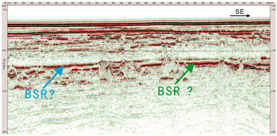
Figure 1.
The seismic profile in this area exhibits ambiguous BSRs (there are two different reflectors, and either of these two reflectors could be the BSR. The location of the 2D seismic profile is shown in Figure 2).
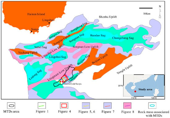
Figure 2.
Location of the study area (modified from [17,18]).
4. Lingnan Low Uplift and Adjacent MTDs in Qiongdongnan Basin
4.1. Classification of Mass Transport Deposits
Moscardelli and Wood (2008) classified deep-water MTDs into two distinctive categories based on their external morphology, triggering mechanism, sedimentary–provenance relationship, and provenance location (Figure 3) [19]. The first category is the adjunct type MTDs, primarily induced by regional geological events and typically producing large-scale MTDs. Adjunct-type MTDs can be further divided into two subcategories: adjunct continental shelf-type MTDs (fed by the marginal continental delta systems and triggered by sea level changes and high sedimentation rates) and adjunct continental slope-type MTDs (caused by upper continental slope collapse in response to earthquakes, coastal currents, or storms). The second category is non-adjunct MTDs, inducing relatively small MTDs due to local geological events. They can be divided into mud volcano or unilateral salt rock uplift, micro basin margin formed by salt rock, and channel-natural dike margin [20].
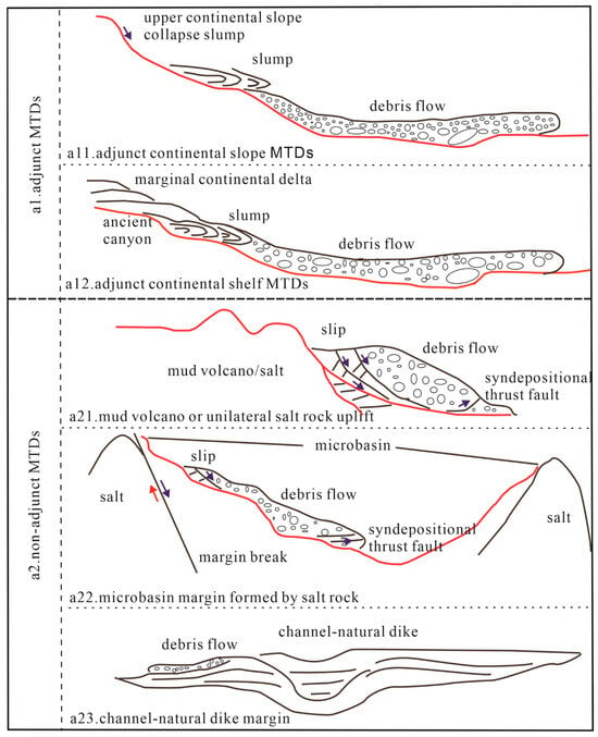
Figure 3.
Classification of deep-water MTDs into two distinctive categories based on their external morphology, triggering mechanism, sedimentary–provenance relationship and provenance location (modified from [21]).
Currently, it is the most crucial approach for identifying deep-water MTDs based on seismic data [22,23]. It is based on the seismic wave response to MTD boundary and internal kinematic direction or anisotropy characteristics to identify the overall morphology of deep-water MTDs or the formation distribution characteristics in the process of transport [20]. Previous research has identified and studied the MTD sedimentary bodies developed in the Qiongdongnan Basin. Wang et al. (2009) pointed out that deep-water MTDs have been widely developed in the continental slope of the Qiongdongnan Basin since the Quaternary period [9]. According to Wang et al. (2011), MTDs are widely distributed in the gas hydrate exploration areas of the Qiongdongnan Basin, and the high deposition rate and over-pressure environment unique to this basin contribute to their formation [24]. Furthermore, MTDs observed in Quaternary sediments are located within the hydrate stability zone. Numerous previous studies have confirmed the existence of a significant number of MTDs within the Qiongdongnan Basin. Based on recently acquired high-resolution 2D and 3D seismic data in the Qiongdongnan Basin, this study focuses on the Lingnan low uplift area and adjacent regions. We present an identification study of BSR in this area, delimiting MTDs that developed during the Late Quaternary across the study area (see Figure 2). Finally, we provide a detailed explanation of the inferred formation mechanism of these MTDs.
4.2. MTDs Identification of Lingnan Low Uplift and Adjacent Areas in Qiongdongnan Basin
Previous studies have shown that MTDs can generally be divided into three structural units, namely head extension area, slip area of the main sediment body, and toe extrusion area [24]. Each segment exhibits unique seismic reflection characteristics that assist in distinguishing between them. Figure 4 displays a slice of the 3D seismic reflection amplitude at a depth of 2100 ms in our study area (as indicated by the red box in Figure 2). Since the head extension area occurs within MTDs and lies in a stretching environment, its seismic reflection is characterized by inconsistent amplitudes and sudden changes in intensity (as depicted in the lower part of Figure 4). The slip area of the main sediment body represents the long-distance transport of sliding blocks, where sediments experience mixtures, compaction, and dehydration by the overlying sedimentary layer during later-stage transport. These factors result in a relatively single lithology, with seismic reflection frequently appearing as a blank zone on the plane (refer to the middle section of Figure 4). The toe compression zone belongs to a compression stress environment, and the seismic reflection also presents as a fuzzy zone. However, its physical properties should be stratified relative to the body slip zone deposits because its force is weaker than that of the body slip zone, the degree of sediment mixing is weak, and the seismic plane properties are enhanced compared to the amplitude of the body slip zone deposits (see the upper part of Figure 4).
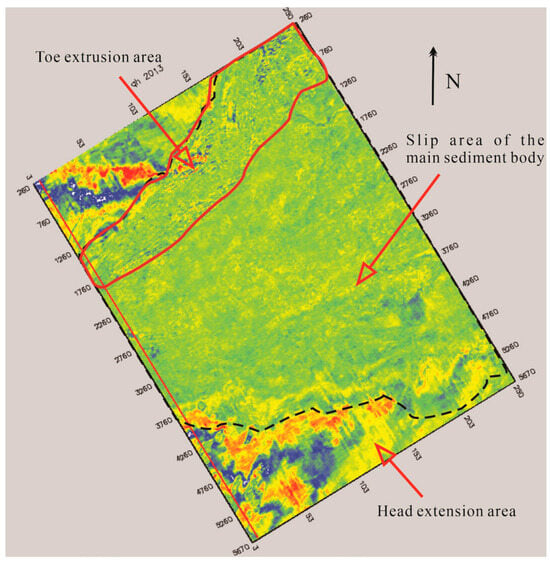
Figure 4.
The slice of 3D seismic reflection amplitude at 2100 ms in the study area, which divides the head extension area, slip area of the main sediment body, and toe extrusion area (the location of the 3D seismic zone is shown in Figure 2).
4.2.1. Head Extension Area
The head extension area of MTDs is readily identifiable during its current stage of development. This region generally develops a back wall characterized by one or more cliffs, which serves as a clear indicator of the extension range for the MTDs’ head. In the area of the development of the back wall, the seabed topography will generally change, the up-dip strata of the cliff usually will not be deformed, and the thickness of the strata in the downdip direction of the cliff will change, or even miss. Due to the tensile stress environment, a series of plow normal faults and small tensile faults commonly develop within the head tension area, which has been described in detail in prior research literature [25]. However, MTDs developed during certain geological periods are often buried beneath newer strata with a certain depth, leading to compaction or erosion of plow-type normal faults and small tensile faults within the head stretching area. The identification of these features can be challenging without high-resolution 3D seismic data. Nevertheless, the tension stress environment leaves distinctive characteristics that remain visible (Figure 5, with section location depicted in Figure 2), and the existence of vertical tensioning small faults is evident from Figure 5.
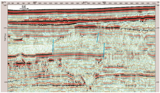
Figure 5.
The seismic profile of the head extension area. Small tensile faults in the head extension area of MTDs due to the tension stress environment (marked in blue near the vertical line) (the location of the 2D seismic profile is shown in Figure 2).
4.2.2. Slip Area of the Main Sediment Body
MTDs are multi-phase sedimentary bodies that originate from unstable geological features situated near continental slopes, canyons, channels, flanks of uplift structures, and channel sidewalls. These features move down the slope via overall “freezing” under gravitational influence for varied reasons [26]. It can be seen that the transport process of MTDs has a certain gravitational potential energy and can form a certain scale effect, which is mainly reflected in the slip area of the main sediment body. Due to the strong transport capacity of MTDs, they are often able to form a certain scale. The plane development area of MTDs identified in the study area in Figure 2 (the range of thick black solid lines) is preliminarily estimated to cover an area of 1240 km2 and the slip area of the main sediment body accounts for more than 75% of the total area (Figure 4). During the long-distance transport of MTDs, due to the uneven strength of sediments overturning and mixing, there are often some unmodified undisturbed strata and residual blocks in MTDs, which become one of the important features to identify the slip area of the main sediment body on seismic profiles (Figure 6, seismic profile location given in Figure 2). In seismic profiles, the physical properties between the residual block and the stirred sediment are different. The strata inside the residual block are continuous, with good stratification and strong amplitude, which is very easy to identify. Moreover, MTDs are severely deformed during transport and may also be subjected to modification by channels and underflows, resulting in an often irregular upper interface that is then filled and altered by various types of sediment fed into the basin, such as channel systems and underflows. The overlying sediments generally appear as channels, floodplains, and possibly matted sand. As shown in Figure 6, the upper interface of the block transport body has been identified in the study area as eroded into irregular grooves with non-uniform erosion degrees across different parts. The closer to the toe area, the stronger the erosion effect is, which may be related to the relatively fine toe area sediment and which is more susceptible to external forces.
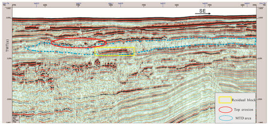
Figure 6.
The seismic profile of slip area of the main sediment body. Residual block and top erosion channel of MTD (the location of the 2D seismic profile is shown in Figure 2).
In addition, during the transportation of MTDs, rapid migration, uneven sediment particle sizes, and energetic migration processes often cause varying degrees of erosion on the bottom shear plane, leading to obviously stepped outlines in local areas with severe erosion. The bottom shear plane is characterized by multiple types of erosion grooves (Figure 7, the seismic profile location is shown in Figure 2).
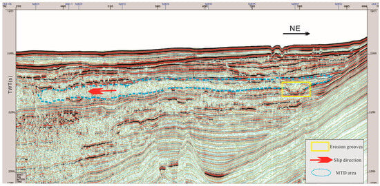
Figure 7.
The seismic profile of slip area of the main sediment body. Characteristics of erosion grooves in the lower part of MTD (the location of the 2D seismic profile is shown in Figure 2).
4.2.3. Toe Extrusion Area
Following the occurrence of MTDs, the sediment therein undergoes long-distance transport resulting in weakened gravitational potential energy. If the transport path encounters obstacles such as topographic protrusions, or if the movement’s energy is depleted, MTDs will cease migration and form a strong extrusion effect on the topographic protrusions. A variety of extrusion structures are developed along the MTD’s toe, characterized by parallel and continuous reflections. As shown in Figure 8 (the seismic profile location is shown in Figure 2), at the end of the marked MTDs (part of which is located inside the lateral wall of the MTDs), imbricated reflection features appear on the seismic profile, showing a typical thrust fault structure.
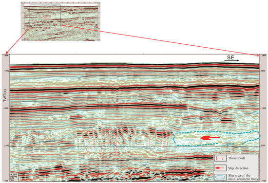
Figure 8.
The seismic profile of the toe extrusion area. The thrust fault structure developed in the toe of MTD (the location of the 2D seismic profile is shown in Figure 2).
Therefore, from the above analysis of the three structural regions, it can be confirmed that this region is definitely developed as MTDs. Although the characteristics are similar to BSR, from the multi-angle analysis on the seismic profile it can be found that the development of MTDs is caused by local structures. Figure 9 points out the velocity response with the sediments. Singular velocity information is not enough to identify MTDs, and seismic profiles are needed to assist in the identification.
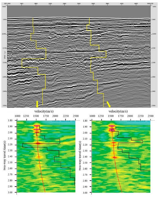
Figure 9.
The seismic profile of toe extrusion area beside the location in Figure 8 and seismic velocity (including the interval velocity).
5. Discussion
5.1. MTDs Trigger Mechanism
At present, the trigger mechanisms of deep-water MTDs are mainly qualitatively characterized [17,26,27]. According to the genetic classification method of deep-water MTDs mentioned above, adjunct MTDs can be further divided into shelf adjuncts and slope adjuncts, which are based on different trigger mechanisms. Shelf adjunct MTDs are mainly affected by three factors, namely deltaic sediment supply shelf margin, fluctuations in sea level, and high sedimentation rates. The study area located in the deep-water continental slope region of the Qiongdongnan Basin does not align with this type. The upper slope collapse type (continental slope dependent type) MTDs are mainly triggered by earthquakes, coastal currents, storms, and other mechanisms. Due to its location in the lower slope environment, it is unlikely for the study area to be associated with this MTD type. Non-adjunct MTDs are triggered by local geological events and can be divided into subcategories such as mud volcanoes, unilateral salt uplifts, and micro-basin margins formed by salt rocks and channel-natural dike margins [26]. According to Xia et al. (2008), the Cenozoic tectonic activities in the Qiongdongnan Basin migrated from north to south as a whole [28], with intense subsidence occurring during the Oligocene (E3) and Pliocene–Quaternary (N2-Q) periods. The latest research also shows that the neotectonic activity in the Qiongdongnan Basin also conforms to this rule, that is, the tectonic activity is early in the north and late in the south [29]. Seismic interpretations of numerous cross-cutting basins indicate that from the Pliocene to the Quaternary period, tectonic activities were particularly pronounced in the southern region of the Qiongdongnan Basin. This caused the uplift and formation of the Yongle uplift block while also leading to the absence of Pliocene and Quaternary strata in several magmatic active zones. Some magma even penetrated the seabed directly, resulting in the creation of volcanoes [30]. Comparisons between Figure 2 and Figure 7 reveal that the Qiongdongnan Basin’s Yongle uplift tectonic belt lies at the southeastern end of the study area. The area has active magmatic activity and was still in the tectonically active stage until the late Quaternary period (Figure 2 and Figure 7). Therefore, we infer that the study area was affected by the late basement uplift (Pliocene–Early Quaternary) in the southeastern Qiongdongnan Basin, which caused the pre-deposited strata to slip and extrude to the northwest direction, finally forming large-scale MTDs in the study area.
5.2. Contribution of MTDs to Gas Hydrate Accumulation Mechanism in the Study Area
Studies on the gas hydrate accumulation mechanism have shown that low temperature and high-pressure environments, adequate gas supply, favorable migration pathways, and good spatiotemporal matching of suitable reservoirs are sufficient and necessary conditions for marine gas hydrate accumulation mechanism. Given the distinctive geological backgrounds of different regions, each of the four reservoir-forming elements has its specific key requisites. With respect to the Qiongdongnan Sea area, recent studies on the temperature and pressure conditions of the gas hydrate accumulation mechanism in the Qiongdongnan Sea area have shown that most areas in the deep-water area of the southeast Qiongdongnan Sea area satisfy the temperature and pressure conditions of gas hydrate formation [30,31,32,33]. In addition, the deep-water oil and gas survey in the Qiongdongnan Basin has shown that the Qiongdongnan Sea area is located in the northwest atmospheric area of the South China Sea. In recent years, oil and gas exploration companies such as China National Offshore Oil Corporation (CNOOC) have successively discovered the LS17-2, LS25-1, and LS18-1 gas fields, as well as the BD21 high-production gas well in the deep-water and ultra-deep-water areas of the Qiongdongnan Basin, which have confirmed the ample gas sources in this area [34,35,36]. The potential gas source foundation of the gas hydrate accumulation mechanism is sufficient. However, the research results of gas hydrate reservoirs, especially a large number of gas hydrate drill-coring studies in the northern South China Sea in recent years, show that gas hydrates may occur in both muddy silty sand and sandy deposits, and the quality of gas hydrate reservoirs is not the key control factor for the gas hydrate accumulation mechanism in this region. Therefore, a good gas migration channel is the key factor for the gas hydrate accumulation mechanism in the Qiongdongnan Sea area.
The fluid transport system of the gas hydrate accumulation mechanism has been the subject of extensive discussion among experts from various fields in the Qiongdongnan Sea area. Wang et al. (2011) first pointed out that polygonal faults, tubular structures, and diapir structures destroyed the sealing property of the huge thick mudstone strata in the thermal settlement stage of the post-fracture in the Qiongdongnan Basin [24], causing a large number of fluids to migrate vertically or nearly vertically upward, providing a good gas migration channel for gas hydrate formation in this area. However, polygonal faults are not universally developed in the Qiongdongnan Basin. Moreover, it is only a small-scale fluid migration channel. Li et al. (2005) showed that the Paleogene fault activity in the Qiongdongnan Basin was strong and controlled sedimentary development [37]. In the early Neogene period, the basin underwent a peak in hydrocarbon generation and expulsion with clear evidence of fault-related fluid migration and hydrocarbon accumulation. However, during the late Miocene and Quaternary rapid subsidence, fault activities exhibited relatively weak vertical fluid transport capacity. The latest high-resolution seismic analysis of gas hydrate also shows that there have been few faults developed in the Qiongdongnan Basin, especially in large depressions, since the late Miocene and most unconformities were developed during the Paleogene era. Therefore, the gas channels of faults and unconformities should not be the dominant fluid migration modes of gas hydrate sources in this area. However, in recent years, there have been recent reports on the discovery of gas hydrates in the Qiongdongnan Sea area, among which a large number of leaking gas hydrates have been found [38]. Moreover, the existence of diffused gas hydrate has also been found [39]. Different scholars have discussed the fluid transport system in the gas hydrate discovery area to different degrees. On the whole, it is widely recognized that gas chimney is the dominant fluid transport mode in the area. However, studies have shown that the gas chimney development area is not completely consistent with the gas hydrate discovery areas. Furthermore, the gas migrating to the gas hydrate stability area relying on the gas chimney also needs a certain mechanism to aggregate to form the possibility of gas hydrate deposits.
Based on previous studies and MTD analysis in this paper, it is proven that MTDs are a widely developed sedimentary mode in the Qiongdongnan Sea area. Moreover, studies have shown that MTDs are a kind of plasticization and clastic flow, during which dehydration and remodeling occur, and differential compaction results in a higher impedance value relative to the surrounding rock, giving it characteristics of low permeability, high resistivity, and high density. The formation with “low permeability and high density characteristics” is a good cap layer for shallow deep-sea fluids. It has a good blocking effect on the upward migration of free gas in the lower stratum, which is conducive to the gas accumulation of hydrate accumulation in the lower stratum. When the fluid pressure blocked under MTDs is high enough, the MTDs’ sedimentary layer will be impaled and broken by the high-pressure hot fluid. At this time, the gas hydrate may be formed in the fracture zone of MTDs, forming a near-vertical fracture along the gas escape channel, enlarging the gas hydrate accumulation space and forming high-quality leaking gas hydrate. Even the fluid continues to move upward to the seafloor surface, forming a “cold seeps” phenomenon (Figure 10).
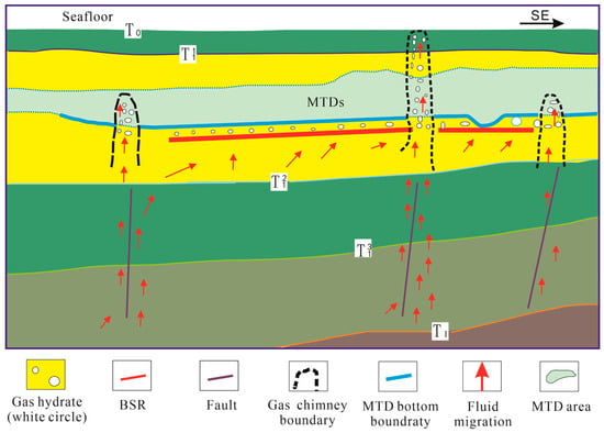
Figure 10.
The relationship between MTDs and gas hydrate accumulation.
6. Conclusions
(1) The MTDs of the study area are identified and delineated, and it is believed that the MTDs of the study area were caused by the late uplift of the southern Qiongdongnan Basin and the early platform uplift, which caused the large-scale collapse and slip of sediments in the central depression of the basin, plasticized and flowed in the long-distance transport process, and finally formed MTDs.
(2) The physical properties of MTDs generally depend on the original sediment type before their formation, which is determined by the deep-water environment in which they are formed, and most of them are mainly muddy. As they are formed by plasticization and clastic flow, dehydration and remodeling will occur in the flow, which determines its characteristics of low permeability and high density. It can form a good blocking effect on the upward migration of free gas in the lower layer and is favorable for gas accumulation of gas hydrate under it.
(3) When the fluid pressure under the MTDs is high enough, the MTDs’ sedimentary layer will be pierced by the high-pressure hot fluid. In this case, the gas hydrate may form in the MTDs’ layer or the entire fluid escape channel, forming high-saturation leakage gas hydrate, or the fluid will even continue to migrate upward to the seabed surface, forming “cold seeps”.
(4) In the process of BSR interpretation and inferential analysis, if the sedimentary background study suggests that MTDs may be formed in the gas hydrate stable zone in the study area, the MTDs’ sedimentary bodies must be accurately identified. Otherwise, they are easy to be confused with the bottom interface of MTDs. The accurate identification of MTD deposits is of great significance to the accurate evaluation of gas hydrate resources in the Qiongdongnan Sea area.
Author Contributions
Conceptualization, J.L. (Jinqiang Liang); Methodology, S.Y.; Formal analysis, W.D.; Investigation, J.L. (Jing’an Lu); Resources, M.M.; Writing—original draft, Y.G.; Writing—review & editing, D.T. All authors have read and agreed to the published version of the manuscript.
Funding
This research was funded by the National Natural Science Foundation of China (No. 42327901); Guangdong Major Project of Basic and Applied Basic Research (2020B0301030003); the China Geological Survey Project (No. DD20221700); the National Development Program of China (No. 2021YFC2800901); the National Natural Science Foundation of China (No. U2244224); the Guangdong Basic and Applied Basic Research Foundation (No. 2022A1515110764); the Basic Foundation of Guangzhou (No. 2023A04J0916); the project funded by China Postdoctoral Science Foundation (No. 2022M720887); National Natural Science Foundation of China (No. 42102144); Guangzhou Science and Technology Planning Project (No. 202201011409).
Institutional Review Board Statement
Not applicable.
Informed Consent Statement
Not applicable.
Data Availability Statement
Data are contained within the article.
Conflicts of Interest
The authors declare that they have no known competing financial interests or personal relationships that could have appeared to influence the work reported in this paper.
References
- Bangs, N.; Sawyer, D.S.; Golovchenko, X. Free gas at the base of the gas hydrate zone in the vicinity of the Chile triple junction. Geology 1993, 21, 905–908. [Google Scholar] [CrossRef]
- Nwoko, J.; Kane, I.; Huuse, M. Mass transport deposit (MTD) relief as a control on post-MTD sedimentation: Insights from the Taranaki Basin, offshore New Zealand. Mar. Pet. Geol. 2020, 120, 104489. [Google Scholar] [CrossRef]
- Weimer, P. Sequence stratigraphy, facies geometries, and depositional history of the Mis sissippi Fan, Gulf of Mexico. AAPG Bull. 1990, 74, 425–453. [Google Scholar] [CrossRef]
- Piper, D.J.W.; Pirmez, C.; Manley, P.L.; Long, D.; Flood, R.D.; Normark, W.R.; Showers, W. Mass-transport deposits of the Amazon Fan. In Proceedings ODP, Scientific Results; Ocean Drilling Program: College Station, TX, USA, 1997. [Google Scholar] [CrossRef]
- Li, W.; Wu, S.G.; Wang, X.J.; Wang, D.; Zhao, F. Seimic characteristics and distribution of pliocene mass transport deposits in central canyon of Qiongdongnan basion. Mar. Geol. Quat. Geol. 2013, 33, 9–15. [Google Scholar] [CrossRef]
- Azadbakht, F.; Monfared, M.S.; Radfar, A. New insights into the geometry of gas chimneys in the Gorgan plain through seismic attribute integration. Acta Geophys. 2023, 1–16. [Google Scholar] [CrossRef]
- Soltani, P.; Soleimani, M.; Aghajani, H. Faults and fractures detection in 2D seismic data based on principal component analysis. Int. J. Min. Geo-Eng. 2017, 51, 199–207. [Google Scholar] [CrossRef]
- Gong, Y.H.; Yang, S.X.; Wang, H.B.; Liang, J.Q.; Liang, J. Prospect of Gas Hydrate Resources in Qiong Dong-Nan Basin. J. Jilin Univ. (Earth Sci. Ed.) 2018, 48, 1030–1043. [Google Scholar] [CrossRef]
- Wang, D.W.; Wu, S.G.; Dong, D.D.; Yao, G.; Cao, Q. Seimic characteristics of quaternary mass transport deposits in Qiongdongnan basin. Mar. Geol. Quat. Geol. 2009, 29, 69–74. [Google Scholar] [CrossRef]
- Ren, J.; Cheng, C.; Xiong, P.; Kuang, Z.; Liang, J.; Lai, H.; Chen, Z.; Chen, Y.; Li, T.; Jiang, T. Sand-rich gas hydrate and shallow gas systems in the Qiongdongnan Basin, northern South China Sea. J. Pet. Sci. Eng. 2022, 215, 110630. [Google Scholar] [CrossRef]
- Geng, M.; Zhang, R.; Yang, S.; Guo, J.; Chen, Z. Focused Fluid Flow, Shallow Gas Hydrate, and Cold Seep in the Qiongdongnan Basin, Northwestern South China Sea. Geofluids 2021, 2021, 5594980. [Google Scholar] [CrossRef]
- Liang, J.; Zhang, Z.; Su, P.; Sha, Z.; Yang, S. Evaluation of gas hydrate-bearing sediments below the conventional bottom-simulating reflection on the northern slope of the South China Sea. Interpretation 2017, 5, SM61–SM74. [Google Scholar] [CrossRef]
- Monteleone, V.; Marin-Moreno, H.; Bayrakci, G. Seismic characterization and modelling of the gas hydrate system in the northern Bay of Bengal, offshore Bangladesh. Mar. Pet. Geol. 2022, 141, 105690. [Google Scholar] [CrossRef]
- Mosher, D.C. A margin-wide BSR gas hydrate assessment: Canada’s Atlantic margin. Mar. Pet. Geol. 2011, 28, 1540–1553. [Google Scholar] [CrossRef]
- Shipley, T.H.; Houston, M.H.; Buffler, R.T.; Shaub, F.J.; Mcmillen, K.J.; Laod, J.W.; Worzel, J.L. Seismic evidence for widespread possible gas hydrate horizons on continental slopes and rises. Am. Assoc. Pet. Geol. Bull. 1979, 63, 2204–2213. [Google Scholar] [CrossRef]
- Liang, J.; Zhang, W.; Lu, J.; Wei, J.; Kuang, Z.; He, Y. Geological occurrence and accumulation mechanism of natural gas hydrates in the eastern Qiongdongnan Basin of the South China Sea: Insights from site GMGS5-W9-2018. Mar. Geol. 2019, 418, 106042. [Google Scholar] [CrossRef]
- Du, H.; Shi, W.Z.; Liang, J.Q.; Wang, R.; He, Y.L.; Xu, L.T. Genesis of mass transport deposits and their effect on gas hydrate accumulation in the Qiongdondnan Basin. Oil Geophys. Prospect. 2021, 56, 869–881. (In Chinese) [Google Scholar]
- Zhang, W.; Liang, J.Q.; Lu, J.A.; Meng, M.M.; He, Y.L.; Deng, W.; Feng, J. Characteristics and controlling mechanism of typical leakage gas hydrate reservoirforming system in the Qiongdongnan Basin, northern South China Sea. Nat. Gas Ind. 2020, 40, 90–99. [Google Scholar]
- Moscardelli, L.; Wood, L. New classification system for mass transport complexes in offshore Trinidad. Basin Res. 2008, 20, 73–98. [Google Scholar] [CrossRef]
- Posamentier, H.W.; Walker, R.G. Deep-Water Turbidites and Submarine Fans. In Facies Models Revisited; SEPM (Society for Sedimentary Geology): Claremore, OK, USA, 2011; pp. 399–520. [Google Scholar] [CrossRef]
- Qin, Y.Q.; Wan, L.K.; Ji, Z.F.; Li, F.H.; Xu, H.L.; Ba, D. Progress of research on deep-water mass-transport deposits. Oil Gas Geol. 2018, 39, 140–152. [Google Scholar] [CrossRef]
- Ratzov, G.; Collot, J.-Y.; Sosson, M.; Migeon, S. Mass-transport deposits in the northern Ecuador subduction trench: Result of frontal erosion over multiple seismic cycles. Earth Planet. Sci. Lett. 2010, 296, 89–102. [Google Scholar] [CrossRef]
- Bull, S.; Cartwright, J.; Huuse, M. A review of kinematic indicatiors from mass-transport complexes using 3D seismic data. Mar. Pet. Geol. 2009, 26, 1132–1151. [Google Scholar] [CrossRef]
- Wang, X.; Wu, S.; Dong, D.; Guo, Y.; Deborah, H. Control of mass transport deposits over the occurrenceof gas hydrate in Qiong Dongnan Basin. Geol. Quat. Geol. 2011, 31, 109–118. [Google Scholar] [CrossRef]
- Wu, S.G.; Qin, Z.L.; Wang, D.W.; Peng, X.C.; Wang, Z.J.; Yao, G.S. Seismic charaetersties and triggering mechanism analysis of mass transport deposits in the northern continental slope of the South China Sea. Chin. J. Geophsics 2011, 54, 3184–3195. (In Chinese) [Google Scholar]
- Qin, L.; Mao, J.X.; Ni, F.L.; Xu, S.; Li, S.; Cai, C.; Shang, W.; Liu, J. A Brief Introduction to Deep-Water Mass-Transport Complexes: Structures, Genetic Classifications and Identification Methods. Adv. Earth Sci. 2020, 35, 632–642. [Google Scholar] [CrossRef]
- Jenner, K.A.; Piper, D.J.W.; Campbell, D.C.; Mosher, D.C. Lithofacies and origin of late Quaternary mass transport deposits in submarine canyons, central Scotian Slope, Canada. Sedimentology 2007, 54, 19–38. [Google Scholar] [CrossRef]
- Xia, B.; Lv, B.F.; Wu, G.G.; Chen, G.W.; Li, W.Q.; Wang, R. The cenozoc tectonic transport and its control on the source rock in the northen south china sea. Nat. Gas Geosci. 2007, 18, 629–634. [Google Scholar] [CrossRef]
- Wang, Z.Z.; Zhu, J.T.; Li, A.Q.; Hu, Q.W.; Mao, X.L.; Yin, H.W. Differential control of structures over reservoirs and its significance in Qiongdongnan Basin. Geol. Quat. Geol. 2021, 41, 157–169. [Google Scholar] [CrossRef]
- Fan, Q.; Li, Q.; Li, L.; Lyu, X.; Zhu, Z.; Sun, T. Gas hydrate accimilation model in the Central Canyon of Southeast Basin of Hainan. J. Northeast. Pet. Univ. 2021, 45, 13–20. [Google Scholar] [CrossRef]
- Chen, D.F.; Li, X.X.; Xia, B. Distribution of gas hydrate stable zones and resource prediction in the Qiongdongnan Basin of the South China Sea. Chin. J. Geophsics 2004, 47, 548–555. [Google Scholar]
- Zhu, J.T.; Deng, Y.; Guo, M.G.; Song, P.; Xiong, X.F.; Mao, X.F.; Li, F.; Huang, S.Z.; He, Y.; Ren, T. Mineralization conditions and accumulation pattern of the gas hydrate in Qiongdongnan basin floor plain. China Offshore Oil Gas 2020, 32, 11–19. [Google Scholar]
- Ren, J.; Xu, L.; Shi, W.; Yang, W.; Wang, R.; He, Y.; Du, H. Shallow Overpressure Formation in the Deep Water Area of the Qiongdongnan Basin. China. Front. Earth Sci. 2022, 10, 922802. [Google Scholar] [CrossRef]
- Huang, B.; Huang, H.; Wang, Z.; Huang, Y.; Sun, Z. Kinetics and model of gas generation of source rocks in the deepwater area, Qiongdongnan Basin. Acta Oceanol. Sin. 2015, 34, 11–18. [Google Scholar] [CrossRef]
- Zhu, W.; Huang, B.; Mi, L.; Wilkins, R.W.T.; Fu, N.; Xiao, X. Geochemistry, origin, and deep-water exploration potential of natural gases in the Pearl River Mouth and Qiongdongnan basins, South China Sea. AAPG Bull. 2009, 93, 741–761. [Google Scholar] [CrossRef]
- Zhu, Y.S.; Wang, Y.Q.; Feng, X.Z.; Wang, D.; Wang, S. Surface sediments and their geotechnical characteristics in the development area of deepwater gas field LS17-2. Mar. Geol. Quat. Geol. 2022, 42, 45–56. [Google Scholar] [CrossRef]
- Li, X.X.; Zhu, G.H. The fault system and its hydrocarbon carrier sigificance in Qiongdongnan basin. China Offshore Oil Gas 2005, 17, 1–7. [Google Scholar] [CrossRef]
- Wei, J.; Liang, J.; Lu, J.; Zhang, W.; He, Y. Characteristics and dynamics of gas hydrate systems in the northwestern South China Sea—Results of the fifth gas hydrate drilling expedition. Mar. Pet. Geol. 2019, 110, 287–298. [Google Scholar] [CrossRef]
- Hu, Y.; Luo, M.; Liang, Q.; Chen, L.; Feng, D.; Yang, S.; Liang, J.; Chen, D. Pore fluid compositions and inferred fluid flow patterns at the Haima cold seeps of the South China Sea. Mar. Pet. Geol. 2019, 103, 29–40. [Google Scholar] [CrossRef]
Disclaimer/Publisher’s Note: The statements, opinions and data contained in all publications are solely those of the individual author(s) and contributor(s) and not of MDPI and/or the editor(s). MDPI and/or the editor(s) disclaim responsibility for any injury to people or property resulting from any ideas, methods, instructions or products referred to in the content. |
© 2024 by the authors. Licensee MDPI, Basel, Switzerland. This article is an open access article distributed under the terms and conditions of the Creative Commons Attribution (CC BY) license (https://creativecommons.org/licenses/by/4.0/).