

A Novelty Methodological Approach to Coastal Scenic Quality Evaluation—Application to the Moroccan Mediterranean Coast


Abstract
1. Introduction
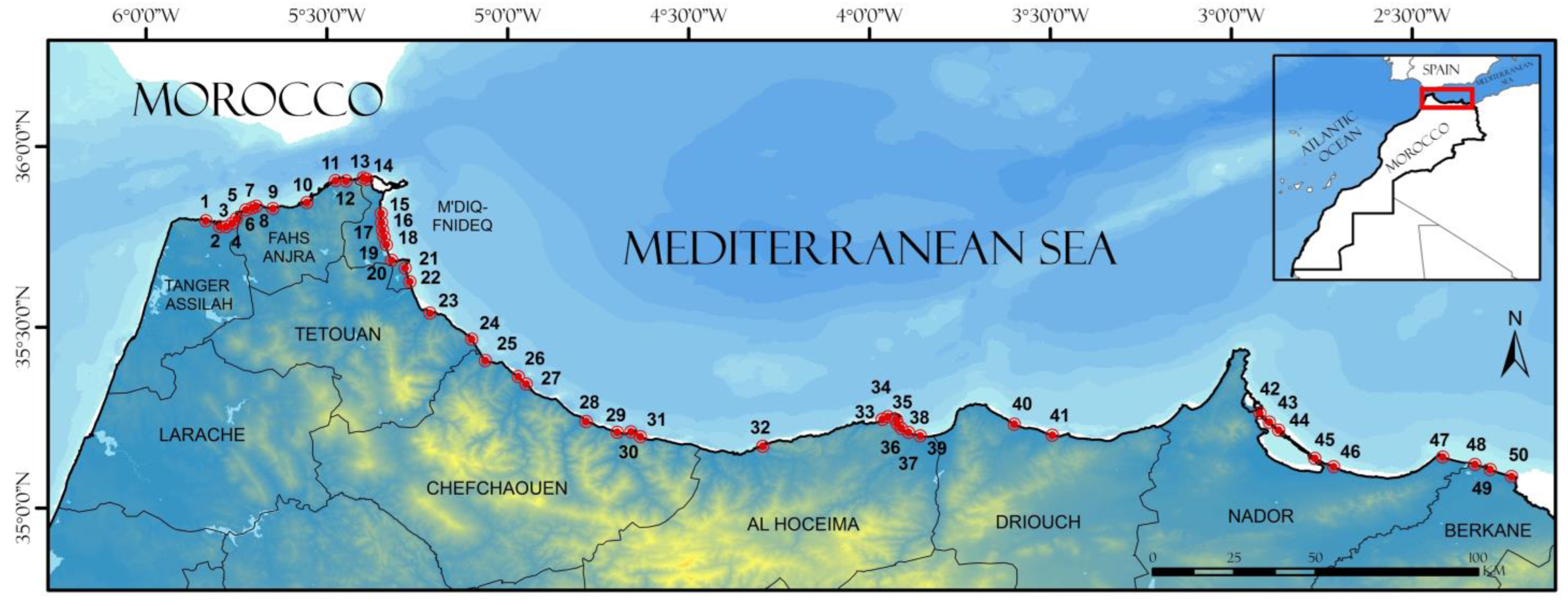
2. Study Area
3. Methods
- Step 1. Search for variables in the literature
- Due to a lack of data, a variable was replaced by another. As an example, environmental quality variables, the evaluation of which is required by González et al. [48] to determine healthy natural spaces that conserve their natural landscapes, is considered by many authors of great importance in any beach evaluation [49]. Therefore, “Foam”, “Tar” and “Oil” were replaced by “Bathing water quality”, “Sand quality” and “Presence of rainwater outfalls”, which are very important for beach users and constitute integrated measures of the aesthetic and hygienic quality of the beach [27,50];
- Due to the specific nature of the beaches investigated, some variables were changed. For example, “Existence of cobble windbreakers” was replaced by the variable “Presence of rocky shore”, since the original one was too specific and its existence limited to the place of application of the original method, and the new one is a very important scenic element for beach classification [25,51];
- It was necessary to change evaluation criteria depending on the type of data available (e.g., “Presence of beach litter” and “Vegetation”, in such cases the ranking of the data was changed from percentage to grades, or from percentage to typology);
- In some cases, related variables have been combined into a single variable (e.g., “Landscape integration of buildings” and “Horizontal line” from the original method have been combined into one variable since both analyze the presence/type of buildings, and named “Landscape Integration of Buildings SB-B”).
- Step 2. Classification and selection of appropriate indicators
- The Substratum (S) dimension includes a set of variables that describe the main structure and composition of the beach substrate within a coastal landscape, i.e., its natural, aesthetic, anthropogenic characteristics and properties [52]. This dimension includes six variables: nature, texture and color of sediment, substratum cleanness, presence of beach litter and presence of rocky shore.
- The Sea-Coastal Area (CA) dimension represents variables concerning the integrated measurement of the aesthetic and environmental quality of the beach [50] measured by natural, aesthetic and anthropogenic variables. It includes six variables: water transparency, bathing water quality, color of water, sand quality, presence of rainwater outfalls and jellyfishes.
- The Vegetation (V) dimension assesses the visual and natural characteristics of the land use/cover. Vegetation is an important parameter for assessing the quality of the landscape, and therefore its management and preservation. This dimension plays a fundamental role in the characterization and conservation of the natural landscape’s diversity [53,54]. The variables identified in the vegetation dimension are: contrast, temporality, structure, color, vegetation debris and agriculture.
- The Scenic Background (SB) dimension describes the visual characteristics of the landscape of a site according to the structure, composition and the general perception of the landscape in terms of the combination of natural and anthropogenic components [42]. This dimension was analyzed according to three major variables: (i) beach background (shape, length, width and slope), (ii) land and marine backgrounds (relief, water bodies, buildings and sea horizon) and (iii) their combination (natural perception, Viewshed and its shape, and landscape diversity).

| D | N° | Variable | Rating | Sources | Method | ||||
|---|---|---|---|---|---|---|---|---|---|
| 0 | 1 | 2 | 3 | 4 | |||||
| Substratum (S) | 1 | Nature (S-N) | Cobbles or boulders | Sand and cobbles | ----- | Coarse sand | Fine sand | [43,55,56] | [43,56] |
| 2 | Texture (S-T) | Cobbles | ----- | Mixed | ----- | Sand | [41,52,57,58,59,60] | [42] | |
| 3 | Color of sediment (S-C) | Black | Brown | ----- | Golden | White | [41,43,50,52,56,57,58,59,60,61] | [43,56] | |
| 4 | Substratum cleanness (S-S) | Unavailable | ----- | Seasonal/ occasional | ----- | Continuous | [43,56] | [43,56] | |
| 5 | Presence of beach litter (S-W) | Poor | Fair | ----- | Good | Excellent | [43,50,56,62] | [62] | |
| 6 | Presence of rocky shore (S-R) | Absent | <5 m | 5–10 m | 10–20 m | >20 m | [51] | [51] | |
| Sea-Coastal areas (CA) | 1 | Water transparency (CA-W) | Muddy | ----- | ----- | ----- | Transparent | [43,50,56,60] | [43,56] |
| 2 | Bathing water quality (CA-B) | Insufficient | Sufficient | ----- | Good | Excellent | [25,31,46,63] | [46] | |
| 3 | Color of water (CA-C) | Muddy brown/grey | Milky blue green; opaque | Green/grey blue | Clear blue/dark blue | Very clear turquoise | [41,50,51,52,57,58,59,64,65] | [51] | |
| 4 | Sand quality (CA-S) | Three types of contamination | Two types of contamination | ----- | One type of contamination | Absent | [66,67,68,69] | Authors | |
| 5 | Presence of rainwater outfalls (CA-R) | Present | Absent | [46,50,51] | [50] | ||||
| 6 | Presence of jellyfishes (CA-J) | Very frequent | Frequent | Infrequent | Very rare | Absent | [50] | [50] | |
| Vegetation (V) | 1 | Contrast (V-C) | No vegetation | Low contrast | ----- | Moderate contrast | High contrast | [43,56,57,70] | [43,56] |
| 2 | Temporality (V-T) | None | Occasional | Seasonal | Permanent | [41,58,60] | [60] | ||
| 3 | Structure (V-S) | Bare (<10% vegetation only) | Scrub/garigue/ grass | Wetland /meadow | Coppices, maquis | Variety of mature trees | [51,58,60,71] | [51] | |
| 4 | Color (V-L) | Brown | ----- | Light green | ----- | Dark green | [57] | [42] | |
| 5 | Vegetation debris (V-D) | Continuous (>50 cm High) | Full strand line | Single accumulation | Few scattered items | None | [51,58] | [51] | |
| 6 | Agriculture (V-A) | None | ----- | Hedgerow/ terracing/ monoculture | ----- | Mixed cultivation ± trees/natural | [51] | [51] | |
| Scenic background (SB) | 1 | Structure of beach–dune system | |||||||
| 1.1 | Beach shape (SB-S) | Closed (3/4) | ----- | Open (1/4) | ----- | Linear (1.5/4–2/4) | [41,43,52,55,56,57,59,60] | [43,56] | |
| 1.2 | Beach length (SB-L) | <250 m | 250-<1000 m | 1000-<2500 m | 2500-<5000 m | >5000 m | [25,43,56] | [25] | |
| 1.3 | Slope (SB-P) | >30% | 0–15% | 15–30% | [41,55,60,72,73] | [60] | |||
| 1.4 | Beach width (SB-W) | Absent | <5 m->100 m | 5-<25 m | 25-<50 m | 50–100 m | [43,51,55,56,65] | [51] | |
| 2 | Scenic background of the system | ||||||||
| 2.1 | Relief of land scenic background (SB-R) | Concave | ----- | Flat | ----- | Dunes/cliffs | [43,51,56,74] | [43,56] | |
| 2.2 | Existence of water bodies (SB-E) | Without water | ----- | ----- | ----- | With water | [43,56,72,73] | [43,56] | |
| 2.3 | Landscape integration of buildings (SB-B) | High-rise on the front line | Low-rise buildings | Stepped buildings on hillside | Sparse buildings | Without buildings | [43,56,59] | [43,56] | |
| 2.4 | Kind of sea horizon (SB-H) | Industrial/ port/shanty | Urban | Agricultural | With islands | Natural or free | [43,56] | [43,56] | |
| 3 | General scenic background | ||||||||
| 3.1 | Natural perception (SB-N) | Dunes, equipment and buildings | ----- | Natural landscape and equipment | ----- | Natural landscape | [36,70,71,75] | [42] | |
| 3.2 | Viewshed (SB-V) | Open on one side | Open on two sides | ----- | Open on three sides | Open on four sides | [51,55,60,72,75] | [51] | |
| 3.3 | Viewshed shape (SB-P) | Small coves | ----- | Open and flat beach | ----- | Cove between cliffs | [41,55,60,72] | [42] | |
| 3.4 | Landscape diversity (SB-D) | Dunes, equipment and buildings | ----- | Natural landscape | ----- | Natural landscape and equipment | [52,58,59,60,64,71,74,75] | [42] | |
- Step 3. Estimation of evaluation criteria for selected variables
- Step 4. Estimation and attribution of landscape variables
- (i)
- Fieldwork for the evaluation and examination of the variables through site observations/estimations (e.g., substratum nature, texture, color of sediment, etc.). As an example, the Substratum dimension has four variables—“Cobbles or boulders”, “Sand and cobbles”, “Coarse sand”, and “Fine sand”. A beach with “Sand and cobbles” is scored 1 and a “Fine sand” beach is scored 4;
- (ii)
- Geographic Information Systems (GIS) to check spatial variables such as beach length, width, slope and Viewshed, etc.;
- (iii)
- Searches for results in the database of public institutions, national reports and guides, for a few variables that require a monitoring program, such as the environmental quality variables (e.g., bathing water quality, sand quality, presence of jellyfishes), and the scores were obtained through the use of this database.
- Step 5. Landscape evaluation
4. Results and Discussion
4.1. Landscape Assessment of Selected Beaches
4.2. Assessment of Dimensions and Landscape Variables
4.2.1. Substratum Value
4.2.2. Sea-Coastal Area Value
4.2.3. Vegetation Value
4.2.4. Scenic Background Value
4.3. Correlation among Landscape Dimension Variables
4.4. The Need to Manage Moroccan Coastal Areas
4.4.1. Dune Maintenance and Enhancement
4.4.2. Beach Litter and Wastewater Management
- From 0.5 to 0.6 (medium to high value)—Rifienne, Stehat 1, Zamana, Isli;
- From 0.7 to 0.8 (high to very high value)—Belyounech 2, Bades;
- From 0.8 to 0.9—Oued Aliane.
- From 0.4 to 0.5—Restinga, Marina Smir, Calabonita, Izdhi, Sabadia, Miami;
- From 0.5 to 0.6 (medium to high value)—Rifienne, Stehat 1.
5. Conclusions
Author Contributions
Funding
Institutional Review Board Statement
Informed Consent Statement
Data Availability Statement
Acknowledgments
Conflicts of Interest
References
- Klein, Y.L.; Osleeb, J.P.; Viola, M.R. Tourism generated earnings in the coastal zone: A regional analysis. J. Coast. Res. 2004, 20, 1080–1088. [Google Scholar]
- United Nations World Tourism Organization. UNWTO Tourism Highlights, 2019th ed.; UNWTO: Madrid, Spain, 2019. [Google Scholar]
- Pranzini, E.; Anfuso, G.; Botero, C.; Cabrera, A.; Apin Campos, Y.; Casas Martinez, G.; Williams, A.T. Beach colour at Cuba and management issues. Ocean Coast. Manag. 2016, 126, 51–60. [Google Scholar] [CrossRef]
- Mejjad, N.; Rossi, A.; Pavel, A.B. The Coastal Tourism Industry in the Mediterranean: A Critical Review of the Socio-Economic and Environmental Pressures & Impacts. Tour. Manag. Perspect. 2022, 44, 101007. [Google Scholar] [CrossRef]
- Leposa, N. Problematic blue growth: A thematic synthesis of social sustainability problems related to growth in the marine and coastal tourism. Sustain. Sci. 2020, 15, 1233–1244. [Google Scholar] [CrossRef]
- Dimitrovski, D.; Lemmetyinen, A.; Nieminen, L.; Pohjola, T. Understanding coastal and marine tourism sustainability—A multi-stakeholder analysis. J. Destin. Mark. Manag. 2021, 19, 100554. [Google Scholar] [CrossRef]
- Smith, T.F.; Elrick-Barr, C.E.; Thomsen, D.C.; Celliers, L.; Le Tissier, M. Impacts of tourism on coastal areas. Camb. Prism. Coast. Futures 2023, 1, E5. [Google Scholar] [CrossRef]
- Dodds, R.; Kelman, I. How climate change is considered in sustainable tourism policies: A case of the Mediterranean islands of Malta and Mallorca. Tour. Rev. Int. 2008, 12, 57–70. [Google Scholar] [CrossRef]
- Alipour, H.; Olya, H.G.; Maleki, P.; Dalir, S. Behavioral responses of 3S tourism visitors: Evidence from a Mediterranean Island destination. Tour. Manag. Perspec. 2020, 33, 100624. [Google Scholar] [CrossRef]
- Mestanza-Ramón, C.; Pranzini, E.; Anfuso, G.; Botero, C.M.; Chica-Ruiz, J.A.; Mooser, A. An Attempt to Characterize the “3S” (Sea, Sun, and Sand) Parameters: Application to the Galapagos Islands and Continental Ecuadorian Beaches. Sustainability 2020, 12, 3468. [Google Scholar] [CrossRef]
- Zorpas, A.A.; Voukkali, I.; Loizia, P. The impact of tourist sector in the waste management plans. Desalin. Water Treat. 2015, 56, 1141–1149. [Google Scholar] [CrossRef]
- United Nations World Tourism Organization. UNWTO Tourism Highlights, 2020th ed.; UNWTO: Madrid, Spain, 2020. [Google Scholar]
- Vaz, B.; Pereira Da Silva, C.; Phillips, M.; Williams, A.T. The importance of user’s perception for beach management. J. Coast. Res. 2009, 56, 1164–1168. Available online: https://www.jstor.org/stable/25737970 (accessed on 18 April 2023).
- Ullah, Z.; Johnson, D.; Micallef, A.; Williams, A.T. Coastal scenic assessment: Unlocking the potential for coastal tourism in rural Pakistan via Mediterranean developed techniques. J. Coast. Conserv. 2010, 14, 285–293. [Google Scholar] [CrossRef]
- Houston, J.R. The economic value of beaches—A 2013 update. Am. Shore Beach Preserv. Assoc. 2013, 81, 3–11. [Google Scholar]
- Blondel, J.; Aronson, J.; Bodiu, J.; Boeuf, G. The Mediterranean Region: Biological Diversity Through Time and Space; Oxford University Press: Oxford, UK, 2010. [Google Scholar]
- Zorpas, A.A.; Tsartas, P.; Aristidis, G.; Theocharous, O. Mediterranean standard for sustainable tourism (MESST)-General requirements, objectives and the philosophy of MESST. Trans. Ecol. Environ. 2008, I, 85–94. [Google Scholar] [CrossRef]
- Luijendijk, A.; Hagenaars, G.; Ranasinghe, R.; Baart, F.; Donchyts, G.; Aarninkhof, S. The state of the world’s beaches. Sci. Rep. 2018, 8, 6641. [Google Scholar] [CrossRef]
- Barragan, J.M.; Andreis, M. Analysis and trends of the world’s coastal cities and agglomerations. Ocean Coast. Manag. 2015, 114, 11–20. [Google Scholar] [CrossRef]
- Ley, C.; Favennec, J.; Gallego-Fernández, J.; Pascual Vidal, C. (Eds.) Conservation des Dunes côtières. Restauration et Gestion Durables en Méditerranée Occidentale; UICN: Gland, Switzerland, 2012; 124p. [Google Scholar]
- Wolanski, E.; Day, J.W.; Elliott, M.; Ramachandran, R. Coasts and Estuaries: The Future; Elsevier: Amsterdam, The Netherlands, 2019; ISBN 978-0-12-814003-1. [Google Scholar] [CrossRef]
- OECD. Sustainable Ocean for All: Harnessing the Benefits of Sustainable Ocean Economies for Developing Countries, The Development Dimension; OECD Publishing: Paris, France, 2020. [Google Scholar] [CrossRef]
- White, V.; McCrum, G.; Blackstock, K.L.; Scott, A. Indicators and Sustainable Tourism: Literature Review; The Macaulay Institute: Aberdeen, UK, 2006. [Google Scholar]
- Rangel-Buitrago, N.; Williams, A.T.; Ergin, A.; Anfuso, G.; Micallef, A.; Pranzini, E. Coastal Scenery: An Introduction. In Coastal Scenery; Rangel-Buitrago, N., Ed.; Coastal Research Library; Springer International Publishing: Cham, Switzerland, 2019; Volume 26, pp. 1–16. [Google Scholar] [CrossRef]
- Williams, A.T.; Micallef, A. Beach Management: Principles and Practice, 1st ed.; Earthscan: London, UK, 2009. [Google Scholar] [CrossRef]
- Council of Europe. The European Landscape Convention (STE no. 176). 2000. Available online: http://www.coe.int (accessed on 18 April 2023).
- Araújo, M.C.B.; da Costa, M.F. Environmental quality indicators for recreational beaches classification. J. Coast. Res. 2008, 24, 1439–1449. [Google Scholar] [CrossRef]
- Williams, A.T.; Rangel-Buitrago, N.; Anfuso, G.; Cervantes, O.; Botero, C. Litter impact on scenery and tourism on the Colombian northern Caribbean coast. Tour. Manag. 2016, 55, 209–224. [Google Scholar] [CrossRef]
- White, M.P.; Smith, A.; Humphryes, K.; Pahl, S.; Cracknell, D.; Depledge, M. Blue space: The importance of water for preference, affect, and restorativeness ratings of natural and built scenes. Environ. Psychol. 2010, 30, 482–493. [Google Scholar] [CrossRef]
- Botero, C.M.; Cabrera, J.A.; Zielinski, S. Tourist Beaches. In Encyclopedia of Coastal Science; Encyclopedia of Earth Sciences Series; Finkl, C., Makowski, C., Eds.; Springer: Berlin/Heidelberg, Germany, 2018. [Google Scholar] [CrossRef]
- Morgan, R. Preferences and Priorities of Recreational Beach Users in Wales, UK. J. Coas. Res. 1999, 15, 653–667. [Google Scholar]
- Espejel, I.; Espinoza-Tenorio, A.; Cervantes, O.; Popoca, I.; Mejia, A.; Delhumeau, S.; Proposal for an integrated risk index for the planning of recreational beaches: Use at seven Mexican arid sites. J. Coast. Res. 2007, SI 50, 47–51. Available online: http://www.jstor.org/stable/26481554 (accessed on 18 April 2023).
- Steers, J.A. Coastal preservation and planning. Geogr. J. 1944, 104, 7–18. [Google Scholar] [CrossRef]
- Fines, K.D. Landscape evaluation: A research project in East Sussex. Reg. Stud. 1968, 2, 41–55. [Google Scholar] [CrossRef]
- Leopold, L.B. Landscape esthetics: How to quantify the scenic of a river valley. Nat. Hist. 1969, 78, 36–45. [Google Scholar]
- Bosque, J.; Gómez, M.; Rodríguez, A.E.; Rodríguez, V.M.; Vela, A. Valoración de los aspectos visuales del paisaje mediante la utilización de un sistema de información geográfica. Doc. Anàl. Geogr. 1997, 30, 19–38. [Google Scholar]
- Wascher, W. European landscapes in transition: Levels of intervention. In Threatened Landscapes, Conserving Cultural Environments; Green, B., Vos, W., Eds.; Spon Press: London, UK, 2001; pp. 129–138. [Google Scholar]
- Penning-Rowsell, E.C. A public preference evaluation of landscape quality. Reg. Stud. 1982, 16, 97–112. [Google Scholar] [CrossRef]
- Kaplan, R.; Kaplan, S. The visual environment: Public participation in design and planning. J. Soc. Issues 1989, 45, 59–86. [Google Scholar] [CrossRef]
- Scott, A. Assessing public perception of landscape: The LANDMAP experience. Land. Res. 2002, 27, 271–295. [Google Scholar] [CrossRef]
- Silva Terán, K.I. Análisis y Valoración del Paisaje de la Parroquia Atahualpa cantón Quito, Provincia Pichincha como Recurso para Potencializar el Turismo. Ph.D. Thesis, Universidad Católica del Ecuador, Quito, Ecuador, 2017; 188p. [Google Scholar]
- Pérez-Hernández, E.; Peña-Alonso, C.; Fernández-Cabrera, E.; Hernández-Calvento, L. Assessing the scenic quality of transgressive dune systems on volcanic islands. The case of Corralejo (Fuerteventura island, Spain). Sci. Total Environ. 2021, 784, 147050. [Google Scholar] [CrossRef]
- Peña-Alonso, C.; Pérez-Chacón, E.; Hernández-Calvento, L.; Ariza, E. Assessment of scenic, natural and cultural heritage for sustainable management of tourist beaches. A case study of Gran Canaria island (Spain). Land Use Policy 2018, 72, 35–45. [Google Scholar] [CrossRef]
- UNEP/MAP. Programme National de Surveillance Intégrée pour les Indicateurs Relatifs à la cote et à L’hydrographie. Secrétariat d’Etat auprès du Ministre de l’Energie, des Mines et du Développement Durable, Chargé du Développement Durable; Département de Développement Durable: Rabat, Maroc, 2016. [Google Scholar]
- Er-Ramy, N.; Nachite, D.; Anfuso, G.; Williams, A.T. Coastal Scenic Quality Assessment of Moroccan Mediterranean Beaches: A Tool for Proper Management. Water 2022, 14, 1837. [Google Scholar] [CrossRef]
- Department of the Environment. Surveillance de la Qualité des Eaux de Baignade. Rapport Analytique. Laboratoire National des Etudes et de la Surveillance de la Pollution; Ministère de l’Energie, des Mines et de l’Environnement: Rabat, Maroc, 2021. [Google Scholar]
- Ministry of Energy, Mines, & Water. Rapport sur l’état de l’environnement; Département de l’Environnement: Rabat, Maroc, 2000. [Google Scholar]
- González, S.; Loyola, D.; Yanez-Navea, K. Perception of environmental quality in a beach of high social segregation in northern Chile: Importance of social studies for beach conservation. Ocean Coast. Manag. 2021, 207, 10561. [Google Scholar] [CrossRef]
- Roca, E.; Villares, M.; Ortego, M. Assessing public perceptions on beach quality according to beach users’ profile: A case study in the Costa Brava (Spain). Tour. Manag. 2009, 30, 598–607. [Google Scholar] [CrossRef]
- Ariza, E.; Ballester, R.; Rigall, R.; Saló, A.; Roca, E.; Villares, M.; Jiménez, J.A.; Sardá, R. On the relationship between quality, user’s perception and economic valuation in NW Mediterranean beaches. Ocean Coast. Manag. 2012, 63, 55–66. [Google Scholar] [CrossRef]
- Ergin, A.; Karaesmen, E.; Micallef, A.; Williams, A.T. A new methodology for evaluating coastal scenery: Fuzzy logic systems. Area 2004, 36, 367–386. [Google Scholar] [CrossRef]
- Aguilo Alonso, M.; Aramburu Maqua, M.P.; Blanco Andray, A.; Calatayud Prieto-Lavin, T.; Carrasco González, R.M.; Castilla Castellano, G.; Castillo Sánchez, V.; Ceñal González Fierro, M.A.; Cifuentes Vega, P.; Diaz Martin, M.; et al. Guía para la Elaboración de Estudios del Medio Físico: Contenido y Metodología; Secretaría General para la prevención de la contaminación y del cambio climático, Serie monografías; Ministerio de Medio Ambiente: Madrid, Spain, 2004; 809p. [Google Scholar]
- Hall, R.M.; Penke, N.; Kriechbaum, M.; Kratschmer, S.; Jung, V.; Chollet, S.; Guernion, M.; Nicolai, A.; Burel, F.; Fertil, A.; et al. Vegetation management intensity and landscape diversity alter plant species richness, functional traits and community composition across European vineyards. Agric. Syst. 2020, 177, 102706. [Google Scholar] [CrossRef]
- Von Thaden, J.; Badillo-Montaño, R.; Lira-Noriega, A.; García-Ramírez, A.; Benítez, G.; Equihua, M.; Looker, N.; Pérez-Maqueo, O. Contributions of green Spaces andIsolated Trees to Landscape Connectivity in an Urban Landscape. Urban For. Urban Green. 2021, 64, 127277. [Google Scholar] [CrossRef]
- Mérida Rodríguez, M.; Vías Martínez, J.M.; Arrebola Castaño, J.A. Propuesta Metodológica para el Análisis Paisajístico de Senderos. 2° Congreso Paisaje e Infraestructuras; Libro de Actas. Consejería de Obras Públicas y Vivienda; Centro de Estudios Paisaje y Territorio: Málaga, Spain, 2010; pp. 115–122. [Google Scholar]
- Peña-Alonso, C. Diseño y Aplicación de Indicadores de Vulnerabilidad y Calidad para Playas y Dunas de Canarias: Una Propuesta Metodológica. Ph.D. Thesis, Universidad de Las Palmas de Gran Canaria, Las Palmas de Gran Canaria, Spain, 2015; 440p. [Google Scholar]
- Muñoz Pedreros, A. La evaluación del paisaje: Una herramienta de gestión ambiental. Rev. Chil. Hist. Nat. 2004, 77, 139–156. [Google Scholar] [CrossRef]
- Otero, I.; Casermeiro, M.A.; Ezquerra, A.; Esparcia, P. Landscape evaluation: Comparison of evaluation methods in a region of Spain. J. Environ. Manag. 2007, 85, 204–214. [Google Scholar] [CrossRef]
- Cañas, I.; Ayuga, E.; Ayuga, F. A contribution to the assessment of scenic quality of landscapes based on preferences expressed by the public. Land Use Policy 2009, 26, 1173–1181. [Google Scholar] [CrossRef]
- Servicio de Evaluación Ambiental (SEA). Guía para la Evaluación de Impacto Ambiental del valor Paisajístico en el Seia; Gobierno de Chile, Servicio Nacional de Turismo: Santiago, Chile, 2019; 115p. [Google Scholar]
- Ortiz, G. El Color de la arena y su efecto en la Percepción del paisaje de Playa en el Pacífico y Caribe Mexicanos. Caso de studio: Colima y Quintana Roo. Ph.D. Thesis, Universidad de Colima, Colima, Mexico, 2020; 70p. [Google Scholar]
- EA/NALG. Assessment of aesthetic quality of coastal and bathing beaches. In Monitoring Protocol and Classification Scheme; Environment Agency and The National Aquatic Litter Group: London, UK, 2000; p. 15. [Google Scholar]
- Unal, O.; Williams, A.T. Beach visits and willingness to pay: Çeşme peninsula, Turkey. In Medcoast 99—Land Ocean Interactions: Monitoring Coastal Ecosystems; Ozhan, E., Ed.; Medcoast: Ankara, Turkey, 1999; pp. 1149–1162. [Google Scholar]
- Bruni, D. Landscape quality and sustainability indicators. Agric. Sci. Proc. 2016, 8, 698–705. [Google Scholar] [CrossRef]
- Da Costa, S.; Portz, L.C.; Anfuso, G.; Camboin, G.; Guimarães, E. Coastal scenic evaluation at Santa Catarina (Brazil): Implications for coastal management. Ocean Coast. Manag. 2018, 160, 146–157. [Google Scholar] [CrossRef]
- Ergin, M.; Keskin, S.; Doğan, Ü.A.; Kadıoğlu, K.Y.; Karakaş, Z. Grain size and heavy mineral distribution as related to hinterland and environmental conditions for modern beach sediments from the Gulfs of Antalya and Finike, eastern Mediterranean. Mar. Geol. 2007, 240, 185–196. [Google Scholar] [CrossRef]
- Sabino, R.; Veríssimo, C.; Cunha, M.A.; Wergikoski, B.; Ferreira, F.C.; Rodrigues, R.; Parada, H.; Falcão, L.; Rosado, L.; Pinheiro, C.; et al. Pathogenic fungi: An unacknowledged risk at coastal resorts? Newinsights on microbiological sand quality in Portugal. Mar. Pollut. Bull. 2011, 62, 1506–1511. [Google Scholar] [CrossRef]
- Díaz Rizo, O.; Buzón González, F.; Arado López, J.O. Assessment of Ni, Cu, Zn and Pb levels in beach and dune sands from Havana resorts, Cuba. Mar Pollut Bull. 2015, 100, 571–576. [Google Scholar] [CrossRef]
- Department of the Environment. Surveillance de la Qualité du Sable des Plages du Royaume. Laboratoire National des Etudes et de la Surveillance de la Pollution; Ministère de l’Energie, des Mines et de l’Environnement: Rabat, Maroc, 2020. [Google Scholar]
- Geronta, C.H. The role of landscape in the sustainable planning and management of tourism destinations: The case study of the Island of Rhodes. In Proceedings of the 5th International Scientific Conference “Tourism Trends and Advances in the 21st Century”, Rodas, Grecia, 30 May–2 June 2013; pp. 1–10. [Google Scholar]
- Fry, G.; Tveit, M.S.; Ode, Å.; Velarde, M.D. The ecology of visual landscapes: Exploring the conceptual common ground of visual and ecological landscape indicators. Ecol. Indic. 2009, 9, 933–947. [Google Scholar] [CrossRef]
- Montoya, R.; Padilla, J.; Standford, S. Valoración de la calidad y fragilidad visual del paisaje en el valle de Zapotitlán de las Salinas, Puebla (México). Bol. A.G.E. 2003, 35, 123–136. [Google Scholar]
- García Romero, A.; Serrano de la Cruz, M.A.; Méndez, A.; Salinas, E. Diseño y aplicación de indicadores de calidad paisajística para la evaluación de atractivos turísticos en áreas rurales. Rev. Geogr. Norte Gd. 2019, 72, 55–73. [Google Scholar] [CrossRef]
- Sowińska-Świerkosz, B.; Chmielewski, T.J. Comparative assessment of public opinion on the landscape quality of two biosphere reserves in Europe. Environ. Manag. 2014, 54, 531–556. [Google Scholar] [CrossRef]
- Estévez-González, V. Calidad y fragilidad visual del paisaje: MCE, fuzzy logic y GIS. In Trabajo Final de Máster en Tecnologías de la Información Geográfica; Universidad Complutense de Madrid: Madrid, Spain, 2012; 234p. [Google Scholar]
- Van der Maarel, E. Some remarks on the functions of European coastal ecosystems. Phytocoenologia 2003, 33, 187–202. [Google Scholar] [CrossRef]
- Carboni, M.; Carranza, M.L.; Acosta, A. Assessing conservation status on coastal dunes: A multiscale approach. Landsc. Urban Plan 2009, 91, 17–25. [Google Scholar] [CrossRef]
- Sheavly, S.B.; Register, K.M. Marine debris and plastics: Environmental concerns, sources, impacts and solutions. J. Polym. Environ. 2007, 15, 301–305. [Google Scholar] [CrossRef]
- Ryan, P.G.; Moore, C.J.; van Franeker, J.A.; Moloney, C.L. Monitoring the abundance of plastic debris in the marine environment. Phil. Trans. R. Soc. 2009, 364, 1999–2012. [Google Scholar] [CrossRef]
- Krelling, A.; Williams, A.T.; Turra, A. Differences in perception and reaction of tourist groups to beach marine debris that can influence a loss of tourism revenue in coastal areas. Mar. Policy 2017, 85, 87–99. [Google Scholar] [CrossRef]
- Brouwer, R.; Hadzhiyska, D.; Ioakeimidis, C.; Ouderdorp, H. The social costs of marine litter along European coasts. Ocean Coast. Manag. 2017, 138, 38–49. [Google Scholar] [CrossRef]
- Chen, C.L.; Bau, Y.P. Establishing a multi-criteria evaluation structure for tourist beaches in Taiwan: A foundation for sustainable beach tourism. Ocean Coast. Manag. 2016, 121, 88–96. [Google Scholar] [CrossRef]
- Aouititen, A.; Bekkali, R.; Nachite, D.; Luan, X.; Mohammed Mrhraoui, M. Predicting Jellyfish Strandings in the Moroccan North-West Mediterranean Coastline. ESJ 2019, 15, 72–84. [Google Scholar] [CrossRef]
- Thorpert, P.; Nielsen, A.B. Experience of vegetation–borne colours. J. Landsc. Arch. 2014, 9, 60–69. [Google Scholar] [CrossRef]
- Rangel-Buitrago, N.; Anfuso, G.; Correa, I.; Ergin, A.; Williams, A.T. Assessing and managing scenery of the Caribbean coast of Colombia. Tour. Manag. 2013, 35, 41–58. [Google Scholar] [CrossRef]
- Anfuso, G.; Williams, A.T.; Cabrera Hernández, J.A.; Pranzini, E. Coastal scenic assessment and tourism management in western Cuba. Tour. Manag. 2014, 42, 307–320. [Google Scholar] [CrossRef]
- Shivlani, M.P.; Letson, D.; Theis, M. Visitor preferences for public beach amenities and beach restoration in South Florida. Coast. Manag. 2003, 31, 367–385. [Google Scholar] [CrossRef]
- Brenner, J.; Jiménez, J.A.; Sardá, R.; Garola, A. An assessment of the non-market value of the ecosystem services provided by the Catalan coastal zone, Spain. Ocean Coast. Manag. 2010, 53, 27–38. [Google Scholar] [CrossRef]
- Lizarbe-Palacios, M.; Aponte, H.; Botero, C.M. Multitemporal Scenic Evaluation of Urban Coastal Sites: A Peruvian Case Study. Water 2022, 14, 2336. [Google Scholar] [CrossRef]
- Tiwari, A.; Oliver, D.M.; Bivins, A.; Sherchan, S.P.; Pitkänen, T. Bathing Water Quality Monitoring Practices in Europe and the United States. Int. J. Environ. Res. Public Health 2021, 18, 5513. [Google Scholar] [CrossRef]
- Anfuso, G.; Martínez del Pozo, J.Á.; Nachite, D. Coastal Vulnerability in the Mediterranean Sector between Fnideq and M’diq (North of Morocco); Bulgarian Academy of Sciences: Sofia, Bulgaria, 2010; Volume 63, p. 4. [Google Scholar]
- Taiqui, L.; Azzouz, M. Le système dunaire de Cabo Negro, patrimoine naturel riche et menacé. In Conservación y Valorización de Koudiat Taifour; Taiqui, L., Araque, E., Youbi, M., Eds.; Al-Khalij Al-Arabi: Tétouan, Maroc, 2008; pp. 74–77. [Google Scholar]
- Wootton, L.; Miller, J.; Miller, C.; Peek, M.; Williams, A.; Rowe, P. New Jersey Sea Grant Consortium Dune Manual; New Jersey Sea Grant Consortium: Fort Hancock, NJ, USA, 2016; 76p. [Google Scholar]
- Anfuso, G.; Martínez del Pozo, J.A.; Nachite, D.; Benavente, J.; Macias, A. Morphological characteristics and medium-term evolution of the beaches between Ceuta and Cabo Negro. Environ. Geol. 2007, 52, 933–946. [Google Scholar] [CrossRef]
- Carter, R.W.G. Coastal Environments, An Introduction to the Physical, Ecological and Cultural Systems of Coastlines; Academic Press: London, UK, 1988; pp. 301–333. [Google Scholar]
- El Mrini, A.; Anthony, E.J.; Maanan, M.; Taaouati, M.; Nachite, D. Beach-dune degradation in a Mediterranean context of strong development pressures, and the missing integrated management perspective. Ocean Coast. Manag. 2012, 69, 299–306. [Google Scholar] [CrossRef]
- Martínez, M.L.; Hesp, P.A.; Gallego-Fernández, J.B. Coastal dune restoration: Trends and perspectives. In Restoration of Coastal Dunes; Martínez, M., Gallego-Fernández, J., Hesp, P., Eds.; Springer: Berlin/Heidelberg, Germany, 2013; pp. 323–339. [Google Scholar] [CrossRef]
- Houston, J.R. Beach nourishment provides resilient protection for critical coastal infrastructure. Shore Beach 2022, 90, 19. [Google Scholar] [CrossRef]
- Anfuso, G.; Williams, A.T.; Casas Martínez, G.; Botero, C.M.; Cabrera Hernández, J.A.; Pranzini, E. Evaluation of the scenic value of 100 beaches in Cuba: Implications for coastal tourism management. Ocean Coast. Manag. 2017, 142, 173–185. [Google Scholar] [CrossRef]
- Pranzini, E.; Williams, A.T. Coastal Erosion and Protection in Europe; Routledge: London, UK, 2013; 457p. [Google Scholar] [CrossRef]
- Sutton-Grier, A.E.; Wowk, K.; Bamford, H. Future of our coasts: The potential for natural and hybrid infrastructure to enhance the resilience of our coastal communities, economies and ecosystems. Environ. Sci. Policy 2015, 51, 137–148. [Google Scholar] [CrossRef]
- Basco, D.R. The economic analysis of ‘‘soft’’ versus ‘‘hard’’ solutions for shore protection: An example. In Proceedings of the 26th International Conference on Coastal Engineering, Copenhagen, Denmark, 22–26 June 1998; Edge, B.L., Ed.; ASCE: New York, NY, USA, 1998; pp. 1449–1460. [Google Scholar]
- Rella, A.; Miller, J. A Comparative Cost Analysis of Ten Shore Protection Approaches at Three Sites under Two Sea Level Rise Scenarios; Hudson River Sustainable Shorelines Project: Staatsburg, NY, USA, 2012; 101p. [Google Scholar]
- Glick, P.; Kostyack, J.; Pittman, J.; Briceno, T.; Wahlund, N. Natural Defenses from Hurricanes and Floods: Protecting America’s Communities and Ecosystems in an Era of Extreme Weather; National Wildlife Federation: Washington, DC, USA, 2014; 70p. [Google Scholar]
- Bridges, T.S.; Banks, C.J.; Chasten, M.A. Engineering with Nature: Advancing system resilience and sustainable development. Mil. Eng. 2016, 108, 52–54. Available online: http://www.jstor.org/stable/26357621 (accessed on 18 April 2023).
- Almarshed, B.; Figlus, J.; Miller, J.; Verhagen, H.J. Innovative coastal risk reduction through hybrid design: Combining sand cover and structural defenses. J. Coast. Res. 2020, 36, 174–188. [Google Scholar] [CrossRef]
- Matsushima, H.; Zhong, X. Challenging a Hybrid Between Green and Gray Infrastructure: Coastal Sand-Covered Embankments. In Green Infrastructure and Climate Change Adaptation; Nakamura, F., Ed.; Springer: Singapore, 2022. [Google Scholar] [CrossRef]
- Omori, Y.; Kuriyama, K.; Tsuge, T.; Onuma, A.; Shoji, Y. Coastal Community Preferences of Gray, Green, and Hybrid Infrastructure Against Tsunamis: A Case Study of Japan. In Green Infrastructure and Climate Change Adaptation; Nakamura, F., Ed.; Springer: Singapore, 2022. [Google Scholar] [CrossRef]
- Yamanaka, R.; Nakagawa, K. Effectiveness and Sustainability of Coastal Hybrid Infrastructures for Low-Frequency Large-Scale Disaster. In Green Infrastructure and Climate Change Adaptation; Nakamura, F., Ed.; Springer: Singapore, 2022. [Google Scholar] [CrossRef]
- Voorendt, M.Z. Design Principles of Multifunctional Flood Defences. Ph.D. Dissertation, Delft University of Technology, Delft, The Netherlands, 2017; 342p. [Google Scholar] [CrossRef]
- Stronkhorst, J.; Lagendijk, O. Toekomstbestendige ver-harde zeeweringen. In Opdracht Van Rijkswaterstaat, Water-Dienst, Rapport 1206188-000-VEB-0009; Deltares: Delft, The Netherlands, 2012; 81p. (In Dutch) [Google Scholar]
- Voorendt, M. Examples of Multifunctional Flood Defences; Working Report; Department of Hydraulic Engineering, Delft University of Technology: Delft, The Netherland, 2015; 72p. [Google Scholar]
- Irish, J.L.; Lynett, P.J.; Weiss, R.; Smallegan, S.M.; Cheng, W. Buried relic seawall mitigates Hurricane Sandy’s impacts. Coast. Eng. 2013, 80, 79–82. [Google Scholar] [CrossRef]
- Williams, A.T.; Khattabi, A. Beach scenery at Nador Province, Morocco. J. Coast. Conserv. 2015, 19, 743–755. [Google Scholar] [CrossRef]
- Jambeck, J.R.; Geyer, R.; Wilcox, C.; Siegler, T.R.; Perryman, M.; Andrady, A. Plastic waste inputs from land into the ocean. Science 2015, 347, 768–771. [Google Scholar] [CrossRef]
- Fossi, M.C.; Pedà, C.; Compa, M.; Tsangaris, C.; Alomar, C.; Claro, F.; Ioakeimidis, C.; Galgani, F.; Hema, M.; Deudero, S.; et al. Bioindicators for monitoring marine litter ingestion and its impacts on Mediterranean biodiversity. Environ. Pollut. 2017, 237, 1023–1040. [Google Scholar] [CrossRef]
- Werner, S.; Budziak, A.; Van Franeker, J.A.; Galgani, F.; Hanke, G.; Maes, T.; Matiddi, M.; Nilsson, P.; Oosterbaan, L.; Priestland, E.; et al. Harm Caused by Marine Litter; European Commission: Ispra, Italy, 2016; p. 92. [Google Scholar]
- Araújo, M.C.B.; Silva-Cavalcanti, J.S.; Costa, M.F. Anthropogenic Litter on Beaches With Different Levels of Development and Use: A Snapshot of a Coast in Pernambuco (Brazil). Front. Mar. Sci. 2018, 5, 233. [Google Scholar] [CrossRef]
- Galgani, F.; Hanke, G.; Maes, T. Global Distribution, Composition and Abundance of Marine Litter. In Marine Anthropogenic Litter; Bergmann, M., Gutow, L., Klages, M., Eds.; Springer: Cham, Switzerland, 2015. [Google Scholar] [CrossRef]
- Munari, C.; Corbau, C.; Simeoni, U.; Mistri, M. Marine litter on Mediterranean shores: Analysis of composition, spatial distribution and sources in north-western Adriatic beaches. Waste Manag. 2016, 49, 483–490. [Google Scholar] [CrossRef]
- Bergmann, M.; Lutz, B.; Tekman, M.B.; Gutow, L. Citizen scientists reveal: Marine litter pollutes Arctic beaches and affects wild life. Mar. Pollut. Bull. 2017, 125, 535–540. [Google Scholar] [CrossRef]
- Anfuso, G.; Bolivar-Anillo, H.J.; Asensio-Montesinos, F.; Manzolli, R.P.; Portz, L.; Villate-Daza, D.A. Beach litter distribution in Admiralty Bay, King George Island, Antarctica. Mar. Pollut. Bull. 2020, 160, 111657. [Google Scholar] [CrossRef]
- Woods, J.S.; Verones, F.; Jolliet, O.; Vázquez-Rowe, I.; Boulay, A.M. A framework for the assessment of marine litter impacts in life cycle impact assessment. Ecol. Indic. 2021, 129, 107918. [Google Scholar] [CrossRef]
- Ministry of Tourism, Handicrafts and Social and Solidarity Economy. Tourisme en Chiffres. Available online: https://mtaess.gov.ma/fr/tourisme/chiffres-cles/ (accessed on 20 February 2023).
- Jang, Y.C.; Hong, S.; Lee, J.; Lee, M.J.; Shim, W.J. Estimation of lost tourism revenue in Geoje Island from the 2011 marine debris pollution event in South Korea. Mar. Pollut. Bull. 2014, 81, 49–54. [Google Scholar] [CrossRef]
- Beaumont, N.J.; Aanesen, M.; Austen, M.C.; Borger, T.; Clark, J.R.; Cole, M.; Hooper, T.; Lindeque, P.K.; Pascoe, C.; Wyles, K.J. Global ecological, social and economic impacts of marine plastic. Mar. Pollut. Bull. 2019, 142, 189–195. [Google Scholar] [CrossRef]
- Nachite, D.; Maziane, F.; Anfuso, G.; Williams, A.T. Spatial and temporal variations of litter at the Mediterranean beaches of Morocco mainly due to beach users. Ocean Coast. Manag. 2019, 179, 104846. [Google Scholar] [CrossRef]
- Asensio-Montesinos, F.; Anfuso, G.; Corbí, H. Coastal scenery and litter impacts at Alicante (SE Spain): Management issues. J. Coast. Conserv. 2019, 23, 185–201. [Google Scholar] [CrossRef]
- Bolívar-Anillo, H.J.; Asensio-Montesinos, F.; Reyes Almeida, G.; Solano Llanos, N.; Sánchez Moreno, H.; Orozco-Sánchez, C.J.; Villate Daza, D.A.; Iglesias-Navas, M.A.; Anfuso, G. Litter Content of Colombian Beaches and Mangrove Forests: Results from the Caribbean and Pacific Coasts. J. Mar. Sci. Eng. 2023, 11, 250. [Google Scholar] [CrossRef]
- Panwanitdumrong, K.; Chen, C.-L. Are Tourists Willing to Pay for a Marine Litter-Free Coastal Attraction to Achieve Tourism Sustainability? Case Study of Libong Island, Thailand. Sustainability 2022, 14, 4808. [Google Scholar] [CrossRef]
- Zielinski, S.; Anfuso, G.; Botero, C.M.; Milanes, C.B. Beach Litter Assessment: Critical Issues and the Path Forward. Sustainability 2022, 14, 11994. [Google Scholar] [CrossRef]
- Burt, A.J.; Raguain, J.; Sanchez, C.; Brice, J.; Fleischer-Dogley, F.; Goldberg, R.; Talma, S.; Syposz, M.; Mahony, J.; Letori, J.; et al. The costs of removing the unsanctioned import of marine plastic litter to small island states. Sci. Rep. 2020, 10, 14458. [Google Scholar] [CrossRef]


| N° | Site | Beach Type | Dimensions | Scenic Quality | |||
|---|---|---|---|---|---|---|---|
| Substratum | Coastal Areas | Vegetation | Scenic Background | ||||
| 1 | Marqala | Urban | 0.7 | 0.5 | 0.8 | 0.4 | 0.6 |
| 2 | Tangier Municipal | Urban | 0.7 | 0.5 | 0.2 | 0.5 | 0.5 |
| 3 | Tangier Malabata | Urban | 0.7 | 0.6 | 0.1 | 0.5 | 0.5 |
| 4 | Ghandouri | Urban | 0.8 | 0.6 | 0.1 | 0.4 | 0.5 |
| 5 | Mrisat | Rural | 0.8 | 0.8 | 0.8 | 0.7 | 0.8 |
| 6 | Playa Blanca | Rural | 0.6 | 0.8 | 0.8 | 0.4 | 0.6 |
| 7 | Sidi Kankouche 1 | Rural | 0.8 | 0.9 | 0.8 | 0.7 | 0.8 |
| 8 | Sidi Kankouche 2 | Rural | 0.8 | 0.9 | 0.8 | 0.7 | 0.8 |
| 9 | Oued Aliane | Rural | 0.8 | 0.8 | 0.9 | 0.8 | 0.8 |
| 10 | Ksar Sghir | Village | 0.7 | 0.5 | 0.3 | 0.5 | 0.5 |
| 11 | Dalya | Rural | 0.8 | 0.8 | 0.8 | 0.6 | 0.8 |
| 12 | Oued El Marsa | Rural | 0.5 | 0.8 | 1.0 | 0.5 | 0.7 |
| 13 | Belyounech 2 | Village | 0.6 | 0.9 | 0.8 | 0.6 | 0.7 |
| 15 | Belyounech 1 | Village | 0.6 | 0.7 | 0.8 | 0.7 | 0.7 |
| 15 | Rifienne | Resort | 0.7 | 0.6 | 0.3 | 0.5 | 0.5 |
| 16 | Almina | Resort | 0.5 | 0.8 | 0.7 | 0.4 | 0.6 |
| 17 | Restinga | Resort | 0.6 | 0.6 | 0.1 | 0.4 | 0.4 |
| 18 | Marina Smir | Resort | 0.6 | 0.6 | 0.1 | 0.4 | 0.4 |
| 19 | Kabila | Resort | 0.5 | 0.8 | 0.1 | 0.4 | 0.4 |
| 20 | M’Diq | Urban | 0.7 | 0.5 | 0.1 | 0.3 | 0.4 |
| 21 | Cabo Negro | Resort | 0.8 | 0.8 | 0.7 | 0.6 | 0.7 |
| 22 | Martil | Urban | 0.7 | 0.5 | 0.5 | 0.6 | 0.6 |
| 23 | Amsa | Rural | 0.5 | 0.9 | 0.9 | 0.5 | 0.7 |
| 24 | Oued Laou | Village | 0.4 | 0.6 | 0.7 | 0.6 | 0.6 |
| 25 | Kaa Asrass | Rural | 0.5 | 0.6 | 0.5 | 0.6 | 0.6 |
| 26 | Stehat 2 | Remote | 0.4 | 0.8 | 0.7 | 0.8 | 0.7 |
| 27 | Stehat 1 | Village | 0.4 | 0.6 | 0.6 | 0.5 | 0.5 |
| 28 | Amtar | Rural | 0.4 | 0.9 | 0.5 | 0.5 | 0.6 |
| 29 | Jebha-Zamana | Village | 0.3 | 0.9 | 0.8 | 0.6 | 0.7 |
| 30 | Jebha-Maresdar | Remote | 0.5 | 0.9 | 0.6 | 0.6 | 0.6 |
| 31 | Jebha-El Hwad | Remote | 0.4 | 0.9 | 0.8 | 0.6 | 0.7 |
| 32 | Bades | Rural | 0.5 | 0.9 | 0.8 | 0.7 | 0.7 |
| 33 | Izdhi | Urban | 0.3 | 0.5 | 0.3 | 0.5 | 0.4 |
| 34 | Sabadia | Urban | 0.4 | 0.5 | 0.5 | 0.4 | 0.4 |
| 35 | Quemado | Urban | 0.8 | 0.8 | 0.8 | 0.4 | 0.7 |
| 36 | Cala Bonita | Urban | 0.3 | 0.6 | 0.6 | 0.3 | 0.4 |
| 37 | Isli | Rural | 0.3 | 0.7 | 0.6 | 0.6 | 0.5 |
| 38 | Sfiha | Rural | 0.5 | 0.8 | 1.0 | 0.5 | 0.7 |
| 39 | Souani | Rural | 0.3 | 0.9 | 0.9 | 0.7 | 0.7 |
| 40 | Sidi Driss | Rural | 0.3 | 0.9 | 0.8 | 0.6 | 0.6 |
| 41 | Sidi Amer O Moussa | Rural | 0.4 | 0.9 | 0.8 | 0.6 | 0.7 |
| 42 | Miami | Urban | 0.6 | 0.6 | 0.1 | 0.4 | 0.4 |
| 43 | Boqueronesa West | Rural | 0.7 | 0.8 | 0.9 | 0.7 | 0.8 |
| 44 | Boqueronesa East | Rural | 0.7 | 0.8 | 0.8 | 0.9 | 0.8 |
| 45 | Taourirt | Rural | 0.8 | 0.8 | 0.9 | 0.7 | 0.8 |
| 46 | Kariat Arekmane | Resort | 0.8 | 0.8 | 0.7 | 0.5 | 0.7 |
| 47 | Ras El Ma | Village | 0.7 | 0.8 | 0.8 | 0.4 | 0.7 |
| 48 | Saïdia Med West | Resort | 0.5 | 0.8 | 0.8 | 0.6 | 0.7 |
| 49 | Saïdia Med East | Resort | 0.5 | 0.8 | 0.7 | 0.5 | 0.6 |
| 50 | Saïdia | Urban | 0.6 | 0.7 | 0.7 | 0.5 | 0.6 |
| Mean | 0.6 | 0.7 | 0.6 | 0.5 | 0.6 | ||
| Substratum (S) | Sea-Coastal Areas (CA) | Vegetation (V) | Scenic Background (SB) | |||||||||||||||||||||||||||
|---|---|---|---|---|---|---|---|---|---|---|---|---|---|---|---|---|---|---|---|---|---|---|---|---|---|---|---|---|---|---|
| S-N | S-T | S-C | S-S | S-W | S-R | CA- B | CA-C | CA-S | CA-R | CA- J | V-C | V-T | V-S | V-L | V-D | V-A | SB-S | SB-L | SB-P | SB-W | SB-R | SB-E | SB-B | SB-H | SB-N | SB-V | SB-P | SB-D | ||
| Substratum | S-N | 1 | ||||||||||||||||||||||||||||
| S-T | 0.970 ** | 1 | ||||||||||||||||||||||||||||
| S-C | 0.463 ** | 0.378 ** | 1 | |||||||||||||||||||||||||||
| S-S | 0.513 ** | 0.485 ** | 0.227 | 1 | ||||||||||||||||||||||||||
| S-W | −0.279 * | −0.294 * | −0.310 * | −0.089 | 1 | |||||||||||||||||||||||||
| S-R | 0.034 | 0.037 | 0.168 | −0.244 | −0.336 * | 1 | ||||||||||||||||||||||||
| S-C. areas | CA-B | −0.124 | −0.105 | −0.078 | −0.317* | 0.322* | 0.140 | 1 | ||||||||||||||||||||||
| CA-C | −0.394 ** | −0.380 ** | 0.301 * | −0.441 ** | −0.131 | 0.218 | −0.053 | 1 | ||||||||||||||||||||||
| CA-S | −0.326 | −0.341 * | −0.310 | −0.323 | 0.109 | 0.179 | 0.120 | 0.000 | 1 | |||||||||||||||||||||
| CA-R | −0.067 | −0.094 | −0.060 | −0.195 | 0.179 | 0.108 | 0.461 ** | −0.188 | 0.101 | 1 | ||||||||||||||||||||
| CA-J | −0.265 | −0.302 * | −0.409 ** | −0.095 | 0.312 * | 0.039 | 0.060 | −0.395 ** | 0.151 | 0.483 ** | 1 | |||||||||||||||||||
| Vegetation | V-C | −0.049 | −0.075 | −0.061 | −0.227 | 0.080 | 0.376 ** | 0.408 ** | 0.013 | 0.051 | 0.617 ** | 0.372 ** | 1 | |||||||||||||||||
| V-T | −0.337 * | −0.361 ** | −0.324 * | −0.261 | 0.149 | 0.237 | 0.186 | −0.070 | 0.218 | 0.572 ** | 0.544 ** | 0.716 ** | 1 | |||||||||||||||||
| V-S | 0.090 | 0.073 | −0.130 | −0.080 | −0.075 | 0.403 ** | 0.197 | −0.077 | 0.202 | 0.514 ** | 0.316 * | 0.816 ** | 0.682 ** | 1 | ||||||||||||||||
| V-L | −0.220 | −0.246 | −0.243 | −0.244 | 0.037 | 0.278 | 0.187 | −0.125 | 0.255 | 0.634 ** | 0.526 ** | 0.761 ** | 0.895 ** | 0.705 ** | 1 | |||||||||||||||
| V-D | 0.237 | 0.197 | 0.146 | 0.310 * | 0.156 | −0.253 | −0.134 | −0.030 | −0.335 * | 0.011 | −0.087 | −0.183 | −0.156 | −0.106 | −0.145 | 1 | ||||||||||||||
| V-A | −0.314 * | −0.363 ** | −0.210 | −0.213 | 0.275 | 0.019 | 0.473** | −0.066 | 0.403 * | 0.417 ** | 0.351 * | 0.328 * | 0.411 ** | 0.260 | 0.342 * | −0.240 | 1 | |||||||||||||
| Scenic background | SB-S | −0.012 | 0.000 | 0.008 | 0.118 | 0.144 | −0.235 | 0.217 | 0.043 | −0.235 | −0.149 | −0.200 | −0.177 | −0.228 | −0.172 | −0.280 * | −0.112 | 0.060 | 1 | |||||||||||
| SB-L | −0.060 | −0.082 | −0.191 | −0.082 | 0.311 * | −0.287 * | 0.192 | −0.209 | 0.287 | 0.091 | −0.106 | −0.072 | 0.086 | 0.065 | 0.026 | −0.198 | 0.292 * | 0.342 * | 1 | |||||||||||
| SB-P | 0.436 ** | 0.419 ** | 0.015 | 0.534 ** | 0.084 | −0.286 * | −0.289 * | −0.452 ** | −0.135 | −0.162 | 0.086 | −0.202 | −0.262 | −0.053 | −0.254 | 0.233 | −0.353 * | 0.062 | 0.091 | 1 | ||||||||||
| SB-W | 0.299 * | 0.244 | 0.285 * | 0.107 | 0.176 | −0.054 | 0.072 | −0.173 | −0.014 | 0.226 | 0.005 | 0.188 | 0.112 | 0.123 | 0.261 | 0.246 | 0.075 | −0.115 | 0.282 * | 0.215 | 1 | |||||||||
| SB-R | −0.199 | −0.247 | −0.257 | −0.074 | 0.108 | 0.337 * | 0.093 | −0.146 | 0.120 | 0.418 ** | 0.471 ** | 0.591 ** | 0.752 ** | 0.476 ** | 0.694 ** | −0.040 | 0.234 | −0.293 * | −0.238 | −0.242 | −0.056 | 1 | ||||||||
| SB-E | 0.125 | 0.091 | −0.051 | 0.211 | −0.027 | 0.123 | 0.018 | −0.031 | 0.000 | −0.144 | −0.141 | 0.029 | −0.002 | 0.192 | −0.147 | −0.075 | 0.154 | 0.233 | 0.131 | 0.323* | −0.114 | −0.009 | 1 | |||||||
| SB-B | −0.355 * | −0.399 ** | −0.011 | −0.371 ** | 0.150 | 0.302 * | 0.320 * | 0.198 | 0.169 | 0.526 ** | 0.388 ** | 0.649 ** | 0.500 ** | 0.395 ** | 0.555 ** | −0.134 | 0.315 * | −0.078 | −0.052 | −0.385 ** | 0.171 | 0.402 ** | −0.156 | 1 | ||||||
| SB-H | −0.302 * | −0.329 * | −0.089 | −0.112 | 0.301 * | 0.184 | 0.437 ** | 0.102 | −0.031 | 0.414 ** | 0.252 | 0.517 ** | 0.469 ** | 0.326 * | 0.468 ** | 0.130 | 0.248 | 0.053 | −0.032 | −0.229 | 0.129 | 0.447 ** | −0.112 | 0.691 ** | 1 | |||||
| SB-N | −0.232 | −0.249 | −0.012 | −0.182 | 0.266 | 0.191 | 0.361 ** | 0.114 | −0.051 | 0.452 ** | 0.315 * | 0.527 ** | 0.353 * | 0.266 | 0.432 ** | 0.037 | 0.076 | 0.028 | 0.068 | −0.078 | 0.251 | 0.246 | −0.133 | 0.787 ** | 0.788 ** | 1 | ||||
| SB-V | 0.221 | 0.247 | −0.196 | 0.146 | 0.066 | −0.158 | 0.283 * | −0.332 * | −0.009 | −0.031 | −0.097 | −0.056 | −0.041 | 0.041 | −0.104 | −0.182 | 0.033 | 0.540 ** | 0.475 ** | 0.167 | −0.039 | −0.143 | 0.141 | −0.175 | −0.008 | −0.039 | 1 | |||
| SB-P | −0.211 | −0.187 | 0.059 | −0.207 | −0.163 | 0.468 ** | −0.034 | 0.399 ** | 0.024 | 0.244 | 0.206 | 0.444 ** | 0.373 ** | 0.287 * | 0.341 * | 0.050 | 0.061 | −0.387 ** | −0.584 ** | −0.377 ** | −0.138 | 0.513 ** | −0.061 | 0.558 ** | 0.385 ** | 0.365 ** | −0.534 ** | 1 | ||
| SB-D | −0.145 | −0.179 | 0.047 | −0.190 | 0.161 | 0.206 | 0.332 * | 0.060 | 0.000 | 0.446 ** | 0.370** | 0.497 ** | 0.368 ** | 0.378 ** | 0.451 ** | 0.032 | 0.250 | 0.070 | 0.025 | −0.150 | 0.325 * | 0.177 | −0.078 | 0.710 ** | 0.704 ** | 0.774 ** | 0.021 | 0.317* | 1 | |
Disclaimer/Publisher’s Note: The statements, opinions and data contained in all publications are solely those of the individual author(s) and contributor(s) and not of MDPI and/or the editor(s). MDPI and/or the editor(s) disclaim responsibility for any injury to people or property resulting from any ideas, methods, instructions or products referred to in the content. |
© 2023 by the authors. Licensee MDPI, Basel, Switzerland. This article is an open access article distributed under the terms and conditions of the Creative Commons Attribution (CC BY) license (https://creativecommons.org/licenses/by/4.0/).
Share and Cite
Er-Ramy, N.; Nachite, D.; Anfuso, G.; Azaaouaj, S. A Novelty Methodological Approach to Coastal Scenic Quality Evaluation—Application to the Moroccan Mediterranean Coast. J. Mar. Sci. Eng. 2023, 11, 953. https://doi.org/10.3390/jmse11050953
Er-Ramy N, Nachite D, Anfuso G, Azaaouaj S. A Novelty Methodological Approach to Coastal Scenic Quality Evaluation—Application to the Moroccan Mediterranean Coast. Journal of Marine Science and Engineering. 2023; 11(5):953. https://doi.org/10.3390/jmse11050953
Chicago/Turabian StyleEr-Ramy, Noureddine, Driss Nachite, Giorgio Anfuso, and Soria Azaaouaj. 2023. "A Novelty Methodological Approach to Coastal Scenic Quality Evaluation—Application to the Moroccan Mediterranean Coast" Journal of Marine Science and Engineering 11, no. 5: 953. https://doi.org/10.3390/jmse11050953
APA StyleEr-Ramy, N., Nachite, D., Anfuso, G., & Azaaouaj, S. (2023). A Novelty Methodological Approach to Coastal Scenic Quality Evaluation—Application to the Moroccan Mediterranean Coast. Journal of Marine Science and Engineering, 11(5), 953. https://doi.org/10.3390/jmse11050953