Article

Sedimentary Facies, Architectural Elements, and Depositional Environments of the Maastrichtian Pab Formation in the Rakhi Gorge, Eastern Sulaiman Ranges, Pakistan

1
Department of Earth Science, Quaid-e-Azam University, Islamabad 45320, Pakistan
2
Department of Earth and Environmental Sciences, Bahria University, Islamabad 44000, Pakistan
3
Department of Geology, Abdul Wali Khan University, Mardan 23200, Pakistan
4
Department of Historical Geology-Paleontology, Faculty of Geology and Geoenvironment, School of Earth Sciences, National and Kapodistrian University of Athens, Panepistimiopolis, Zografou, 15784 Athens, Greece
5
Department of Geology, Shaheed Benazir Bhutto University, Sheringal 18050, Pakistan
6
Department of Geology, University of Malakand, Chakdarrah 18000, Pakistan
*
Authors to whom correspondence should be addressed.
J. Mar. Sci. Eng. 2023, 11(4), 726; https://doi.org/10.3390/jmse11040726
Submission received: 27 January 2023 / Revised: 9 March 2023 / Accepted: 24 March 2023 / Published: 27 March 2023
(This article belongs to the Special Issue Recent Advances in Sedimentology)

Abstract

:
An integrated study of sediments was conducted to examine the facies architecture and depositional environment of the Cretaceous Pab Formation, Rakhi Gorge, and Suleiman Ranges, Pakistan. This research focused on analyzing architectural elements and facies, which are not commonly studied in sedimentary basins in Pakistan. To identify lithofacies, outcrop analysis and section measurement were performed. The identified lithofacies were then categorized based on their depositional characteristics and facies associations, with a total of nine types identified within a stratigraphic thickness of approximately 480 m. These facies were mainly indicative of high-energy environments, although the specifics varied by location. Sedimentary structures such as planar and trough crossbedding, lamination, nodularity, load-casts, and fossil traces were found within these facies, indicating high-energy environments with a few exceptions in calm environments. The identified facies were grouped into seven architectural elements according to their depositional environments: delta-dominated elements, including laminated shale sheet elements (LS), fine sandstone elements (SF), planar cross-bedded sandstone elements (SCp), trace sandstone elements (ST), and paleosol elements (Pa); and river-dominated elements, including trough cross-bedded sandstone elements (SCt), channel deposit elements (CH), and paleosol elements (Pa). These architectural elements, along with their vertical and lateral relationships, indicate a transitional fluvio-deltaic environment within the Pab Formation. In conclusion, by interpreting facies and architectural elements, it is possible to gain a better understanding of the depositional history of the formation and the distribution of reservoir units.

1. Introduction

Architectural element analysis of the fluvial and fluvio-deltaic transitional sedimentary sequences has been studied by different researchers around the world during the last few years [1,2,3,4]. Field studies, outcrop analysis, and section measurement have been considered of prime importance in the study of architectural element analysis. Due to a series of cyclic depositional events, lateral and vertical facies migration, and the superposition of depositional units, the study of architectural element analysis has always been exceedingly difficult [4]. Facies description and sedimentary architecture elements are well studied throughout the world in different sedimentary basins. These studies are very important for the explanation of traditional scientific knowledge, but they are also important for economic purposes. These rocks can act as good reservoir rocks [5]. Research on architectural elements preserved in the fluvial and transitional marine deposits in Pakistan is not fully developed yet. However, clastic deposits are of great importance in terms of their hydrocarbon potential. The eastern Sulaiman ranges contain some excellent Cretaceous sedimentary succession exposures, including the Pab Formation. These rocks are very well exposed along the roadside cut. The lithologic units belonging to the study area are located in an active fold-belt region and are therefore very important in terms of their geology and reservoir properties [5] (Figure 1). Thick siliciclastic sequences of the Pab Formation are well exposed (480 m thickness) in the Rakhi gorge [6] and composed of thick sandstone beds with thinner interbedded horizons of shales, clays, and paleosols. Although the Pab Formation has been studied by various researchers in terms of its reservoir properties and geophysical studies, explanations regarding its fluvial-deltaic characters and architectural elements are not very well understood [7,8]. The sediments of this succession deliver one of the best prospects for sedimentological study in the eastern Sulaiman Ranges.
This study is aimed at investigating the first detailed facies analysis within the Pab Formation in the Rakhi Gorge section. Understanding the facies will provide insights into the depositional environment in which the sandstone was formed. Moreover, this study will provide valuable information about the depositional processes and sedimentary environments of the past. The goal of the study also includes explaining the cyclic depositional events of the different facies, including architectural elements of the Pab Formation. The target of the architectural element analysis is to get a better understanding of the clastic input within the fluvio-deltaic succession as well as their lateral and vertical arrangement within the formation’s units, which is also critical in assessing the reservoir quality of sandstone deposits. Porosity, permeability, and grain size distribution are key factors that determine the potential for hydrocarbon accumulation in sandstone reservoirs. Through the sedimentary facies identification and architectural element analysis, the present study uses the fluvial facies knowledge as a solid foundation for the future identification of multiple sedimentary facies in the field of lithofacies paleogeography. The optimized understanding of sandstone lithofacies and architectural elements is important for a range of geological applications, including hydrocarbon exploration, paleoenvironmental reconstruction, and stratigraphic correlations.

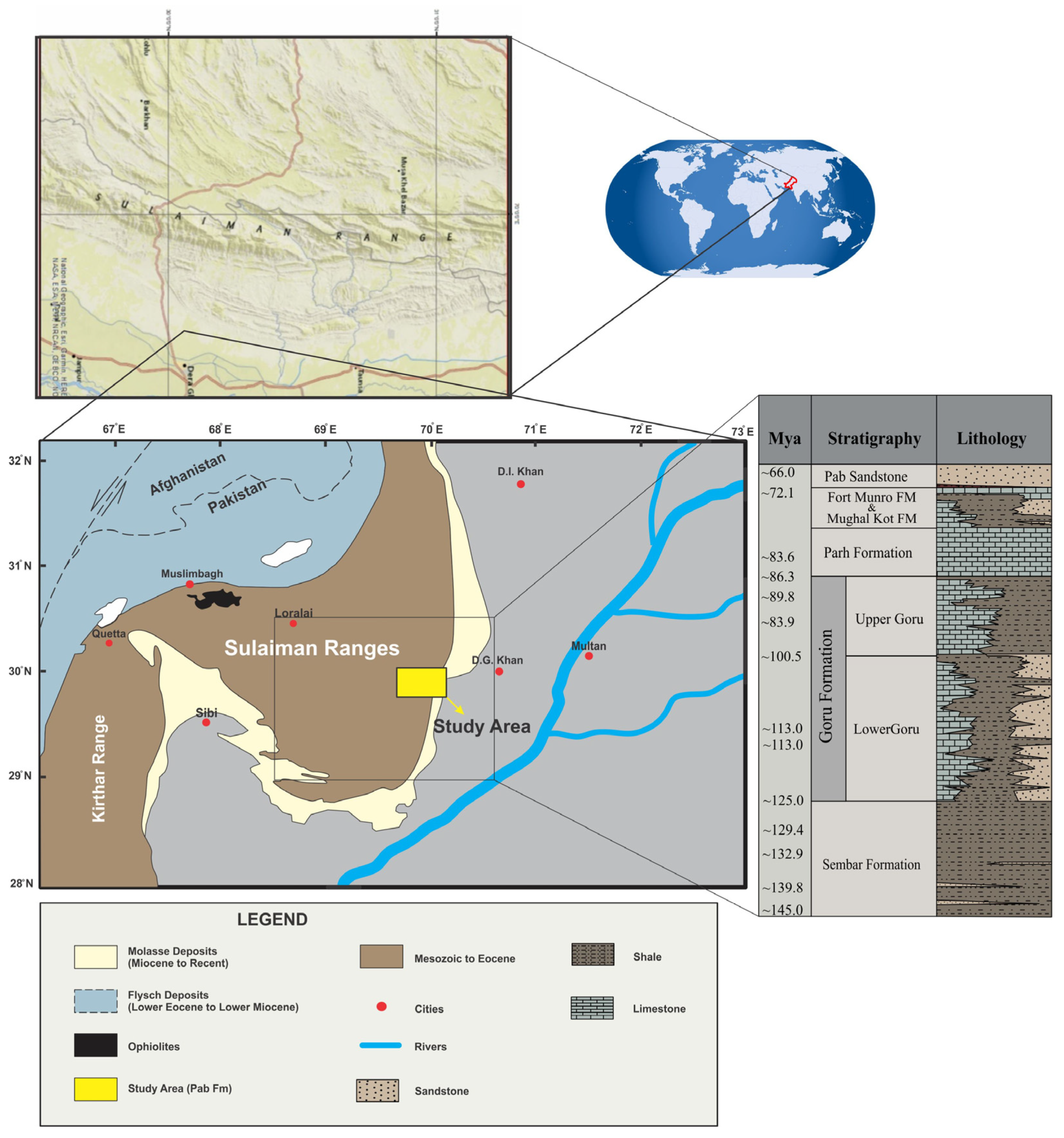
2. Geological Setting

Along the western edge of the Himalayan collisional belt, there are many faults and fold-thrust belts [9,10,11]. Because of these faults and fold and thrust belts, Pakistan is split into different tectonic belts that extend from the Salt Range in the north-east to the Kirthar and Sulaiman Ranges in the south-west. Vernant et al. [12] identified that the westernmost strike-slip fault has been extended to the fold and thrust sequences in the Makran subduction zone. This is where the Oceanic-Arabian plate passes under the Eurasian plate in Afghanistan. The Himalayas and Eurasia are drawing closer together in the north. This is assumed to be the result of the subduction. When the Indian and Eurasian plates collided about 30 Ma ago, they caused a fold and thrust belt to form in the Sulaiman Ranges. Because the Indian Plate moves counterclockwise and strikes the Eurasian Plate, the Sulaiman Ranges have some of the most complicated tectonic features in the world [13]. The Sulaiman lobe was formed by strike-slip movement to the left along the Chaman fault and southward thrusting along the western edge of the Indian subcontinent. The molasse layers kept changing because of prograde deformation, which moved the center of deposition to the south and east [14]. The study area and outcrop are located in an area called the “Rakhi Gorge”, which is in the eastern Sulaiman Ranges of the Central Indus Basin (Figure 1). The Sulaiman Fold belt is a large tectonic structure close to the collision zone. Even though the Pab Formation has the same types of rocks in both the Central and Southern Indus Basins, it seems to have formed in different geographic locations in each basin. Numerous faults along with the fold-thrust belts are present along the western margin of the Himalayan collisional belt [13,14]. As a result of these faults and fold and thrust belts, Pakistan has been divided tectonically into different belts extending from the Salt Range in the north-east to the Kirthar and Sulaiman Ranges in the south-west. The westernmost strike-slip fault has been extended up to the fold and thrust sequences present in the Makran subduction zone, where the Oceanic Arabian plate is subducted under the Eurasian plate (Afghanistan) [12]. The ultimate consequence of the subduction has been linked with the Himalayan-Eurasian convergence in the north. The Sulaiman Ranges were formed as a fold and thrust belt due to the collision between the Indian and Eurasian plates about 30 Ma ago [12]. The Sulaiman Ranges have some of the most intricate tectonic features in the world as a result of the Indian Plate’s counterclockwise rotation, resulting in the clash with the Eurasian Plate [13]. Due to left-lateral strike-slip motion along the Chaman fault and southward thrusting along the western edge of the Indian subcontinent, the Sulaiman lobe was formed through transgression. Prograde deformation kept changing the molasses layers, which moved the center of deposition to the south and east [14]. The study region (Pab Formation) and associated successions was deposited on the north-western margin of the Indian plate derived and originated from the Aravali and Deccan ranges [14]. These are now located in the Central Indus Basin’s eastern Sulaiman Ranges (Figure 1). The Sulaiman Fold Belt is a significant tectonic structure close to the collision zone. Despite having identical lithological components in both the Central and Southern Indus Basins, the Pab Formation appears to have been deposited in different environments in both basins [14].

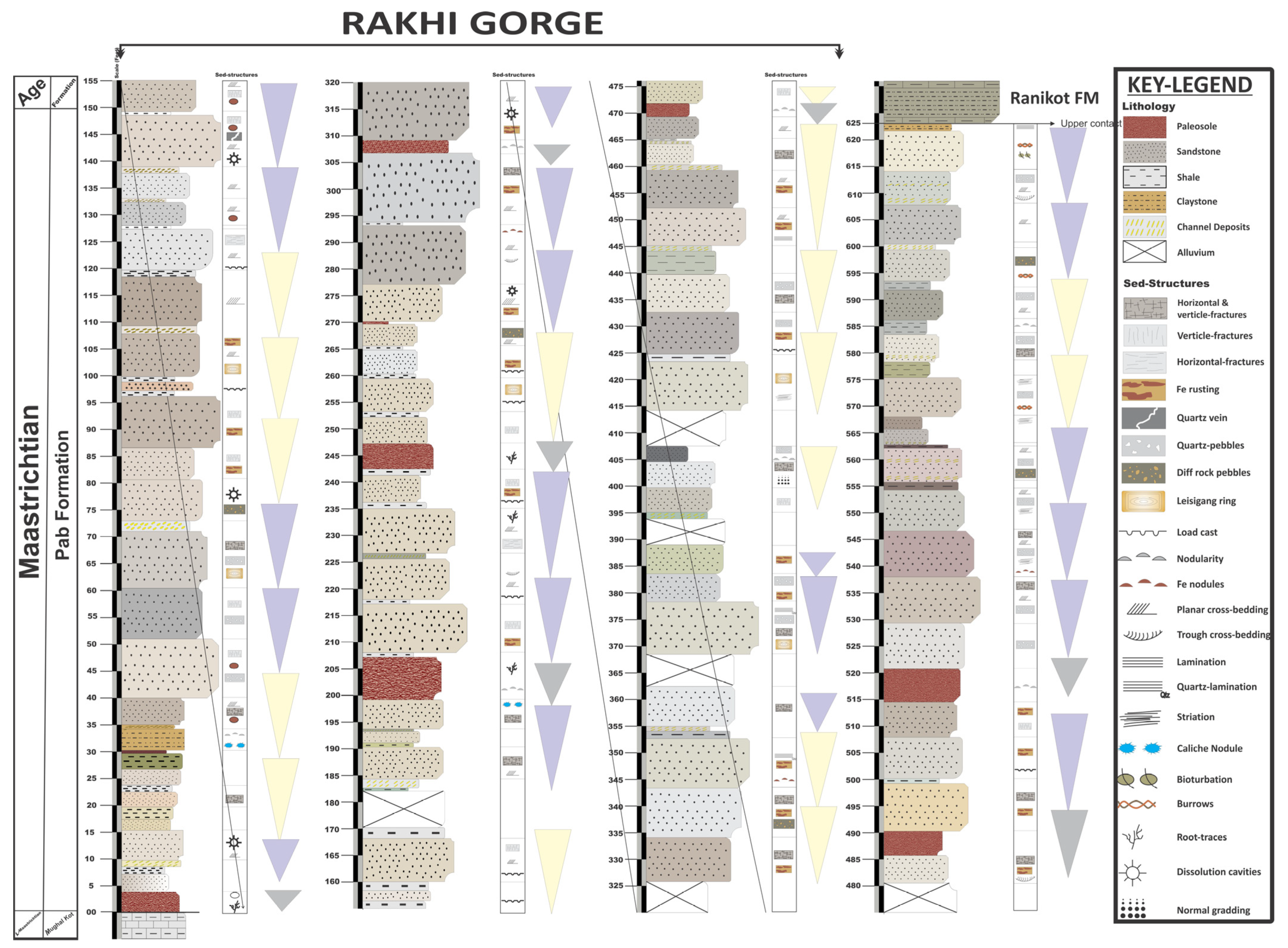
2.1. Stratigraphy of the Study Area

In the Central Indus Basin, the Cretaceous succession includes alternating carbonate and clastic intervals and includes the Mughal Kot, Ranikot, and Pab Formations with more than 1500 m thickness along the Rakhi Gorge anticline (Figure 1 and Figure 2). The Pab Formation is generally devoid of fossil assemblages; however, Vredenburg [15] reported some Cretaceous Orbitoides minor species in the Pab Formation. No detailed biostratigraphic record is present or published yet. The Pab Formation (with interbeds of clay and shale) reaches a maximum thickness of 480 m along the eastern limb of the Mughalkot anticline in the eastern Sulaiman Ranges. The Paleocene and Cretaceous sections are divided by a locally preserved unconformity characterized by red lateritic nodules. The Ranikot Formation of lower Paleocene age was deposited in a variable setting and consists of strata that are sandy in the eastern part and shaly in the western part [5]. The Paleocene strata are represented by the Dunghan Formation, which is primarily limestone in the eastern and western portions with some shale units present in the central part.

Pab Formation

The Eastern-Sulaiman Fold belt contains the double-plunging Fort Munro anticlinorium. The oldest rock exposed in Rakhi Gorge is the Late Cretaceous Mughal Kot Formation. The Late Cretaceous Mughal Kot (mudstone/marl, and sandstone), Fort Munro Limestone and Pab Sandstone, and the latest Cretaceous Vitakri Formation (sandstone and red mudstone) of the Fort Munro Group are exposed in the Shadiani, Rakhi Gaj, and other gorges as core strata [15]. The Cretaceous Pab Formation consists of sandstone with minor shale units. The study area is present within the Rakhi Gorge section of the Eastern Sulaiman Ranges, where the lower contact of the Pab Formation is with the late Cretaceous Mughal Kot Formation and the upper contact is with the Paleocene Ranikot Formation. The first unit of the Pab Formation in the Rakhi Gaj area is the Paleosol unit. At the lower contact of the Pab Formation, the total thickness of the paleosol unit is 5.4 m. The paleosol varied in color from pale brown to rusty brown. The paleosol unit recognizes different layers at the base of color variation. The paleosol is recognized in the Pab Formation at different locations, and therefore, its thickness is varied at different locations in the field. The Pab Formation is dominantly sandstone. The sandstone unit is mostly medium grains to very coarse; some beds are fine grains, subangular to subrounded, and moderately sorted (Figure 2 and Figure 3A,B). The Pab Formation has some thin shale units. The shale is a dusty yellowish green claystone that ranges from light olive gray to grayish olive gray. The lower part of the Pab Formation consists of intercalated claystone and shale. The claystone is sandy and very fine-grained locally.

3. Material and Methods

In Rakhi Gorge, Eastern Sulaiman Range, the Pab Formation of the Cretaceous age was examined in depth. A comprehensive field investigation was conducted to reconstruct the depositional environment of the Pab Formation by analyzing the facies and sedimentary architectural features. Sedimentary characteristics of the lithological assemblages and units were considered and studied in detail. The details from the sedimentological record of the formation and the characters were evaluated using the Miall classification schemes [16,17,18] for facies and architectural elements. The facies codes and classification scheme of Farrell et al. [19] were also used. Different depositional cycles and facies associations were identified. Using field data, a complete lithological record of the formation was compiled (Figure 2). On the log, the lithologic units were denoted and documented according to their representative properties. Based on their respective qualities, traditional sedimentology concepts have been used to distinguish the various units. By performing textural, mineralogical, depositional, and provenance analyses, sandstone samples were systematically collected to define the classification’s key components. QFL diagrams were used to analyze the composition and origin of the examined samples [20]. Nevertheless, the exact depositional environment of the formation has been determined through a combined evaluation of petrography, architectural elements, and facies study. Individual architectural elements have been evaluated based on a detailed analysis of the corresponding facies set [18]. The cyclicity of the facies and architectural elements in this paper are presented based on a modified version of the classification system after Ghazi et al. [21]. Thirty thin-section investigation slides were prepared and studied under the petrographic microscope in the Petrographic Laboratory of the National Center of Excellence in Geology, University of Peshawar. The Gazzi and Dickinson point counting method was used, and a total of 400-point counts were used to study the thin section. Sandstone categorization models, which provide the percentages of three framework grains on a QFR ternary diagram [20,21,22], namely quartz, feldspar, and rock fragment, were used to analyze the detrital grain composition of the examined sandstone samples.

4. Results

4.1. Petrography

The late Cretaceous Pab Formation is dominated by fine to extreme coarse-grained and well-sorted sandstone. According to detrital mineral composition, Pab sandstone is mostly quartz arenite and partly sublitharenite. The average modal composition of the sandstone, based on the QFL diagram, was Q 93% F 0.4% L 3.7%, and the percentages derived based on the QmFLt diagram were Qm 91% F 0.33% L 2.3%. The petrographic study of Pab sandstone shows grain-to-grain contact that is concave to convex, point, sutured, and plane contacts. The Pab sandstone reservoir is dominantly a fine- to medium-grained, course-to very coarse-grained, moderately to well sorted, cross-bedded quartz arenite of possible fluvio-deltaic origin. Based on the QFR [22] and QmFLt diagrams of Dickinson and Suczek [20], the source area for Pab Formation deposits was Quartz recycled to the cratonic interior (Figure 3). The formation is present in an active fold belt, and the results from the microscopic study show that in some samples, the quartz exhibits concave-convex contact, with some showing plane contact (Figure 3A,B). The formation is composed of very coarse- to coarse-grained quartz (mono-crystalline); however, in some places fine-grained (poly-crystalline) sandstone is also found (Figure 3C,D). These results show that the sediments present in the Pab Formation are derived from an origin present at a greater distance (Figure 3E,F).
Figure 3. (A) Concave–convex contact highlighted by green arrows between medium- to coarse-grained sandstone; (B) plane contact highlighted by the yellow arrows; (C) (Qm) mono-crystalline quartz grains; (D) (Cp) poly-crystalline quartz grain; (E) classification of sandstone showing the quartz-arenite with a few samples belonging to sub-litharenite; and (F) classification showing the Cratonic interior origin of the sandstone [20,21,22].
Jmse 11 00726 g003

4.2. Lithofacies

The Eastern Sulaiman Range’s Pab Formation sediments are divided into different lithofacies that maintain a record of the depositional conditions. Using the Miall [23] classification technique, the Pab Formation can be divided into nine lithofacies. All these lithofacies are defined by their sedimentary structures, types of sediment, bed thickness, and sediment grain sizes (Table 1).

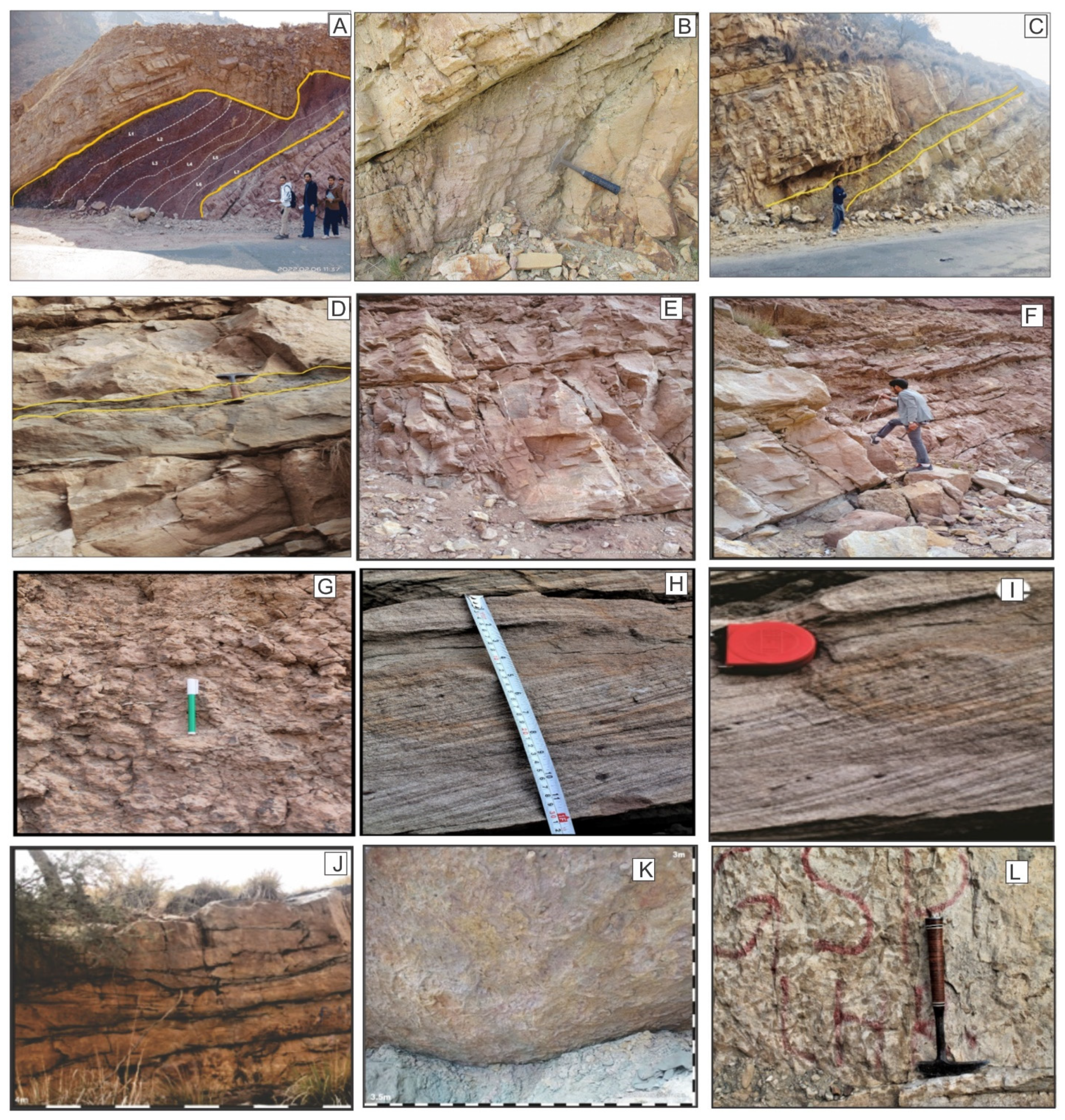
4.2.1. Paleosol Facies (Pf)

Description: The Paleosol facies represents 10% of the total succession. The maximum thickness of the paleosol facies identified in the formation is around 5.4 m. However, the thickness is not uniform and varies at different places. The sediments in these facies are fragmented and devoid of sedimentary features. These facies consist of different features, including peds and cutans. Abundant visible cones and cone structures are found. These facies consist of fine-grained sediments, including clays and silt. The color of this facies is variable, i.e., from dark brown to rusty reddish and, in some places, pale brown (Figure 4A). The sedimentary characters of these facies are nodular and contain traces of ancient rootlets.
Interpretation: the characteristics and properties the paleosol consist of is indicative of the environment of formation. The properties of the paleosol exhibit the past climate, exposure of sediments and their time, the environmental influence including flooding conditions [24]. They also indicate the source rock characters and mineralogical characters of the parent material [25]. Root traces, soil structure, and soil horizons are the three characteristics that characterize paleosols. Paleosols are useful local marker beds, and as a result, they may provide essential data on basin stratigraphy. The presence of root traces is one of the most important diagnostic indicators. If there are no other indications of ancient soil formation, the presence of root remains on a rock indicates that it was formerly open to the atmosphere and inhabited by plants and is thus a soil by almost any definition [25]. This lithofacies is indicative of soil formation in a humid climate, as most of the authors suggest a humid climate for reddish paleosols with abundant bioturbation and root traces [26,27].

4.2.2. Sandstone with Channel Deposit Facies (Sch)

Description: The channel-deposit sandstone facies is common throughout the formation and occurs at different intervals. This facies accounts for approximately 11% of the total succession. The channel deposits range in thickness from 0.08 to 0.16 m and reach 8 to 10 m in some intervals. These facies are found in association with the fine-grained sandstone beds. The thickness of the channel deposit facies varies throughout the formation (Figure 4B). These facies consist of coarse-grained sediment particles. In certain instances, the sand-gravel size of the channel deposit facies is clearly different from the grain size of the associated upper and lower sandstone beds. This facies also contains quartz sediments with a 1-cm diameter. Cross-bedded sedimentary structures are common sedimentary structures found in channel deposit facies. However, these deposits are found in sandstone with coarse grains, and the channel grains are poorly sorted and have irregular shape and size. Fining upward sequences have been observed within the channel deposit facies at some locations.
Interpretation: The coarse-grained, channelized sandstone bodies are deposited as a result of small bodies of channels. The coarse grain particle usually represents the running water and energy conditions [28]. The existence of planar sedimentary structures represents the transitional environment, which is a kind of and intermediate zone between the deltaic channels and marine. The presence of large amounts of coarse pebbles represents high-energy conditions [29]. The high-energy rivers and channels are responsible for the transport of various loads, including suspended and bed loads [30]. The poor sorting of the sediments and the abundance of large-sized clasts suggest a high-energy environment and quick sedimentation [31]. The properties of this facies represent deposition from a high-velocity environment within a channel [32]. Based on the characteristics of these facies, it is assumed that they have been formed through a channel levee complex. It represents the deposition along the channel margins as a result of high-energy currents.

4.2.3. Thin Bedded Claystone Facies (Cf)

Description: This facies represents 2% of the whole succession. The thickness of the clay beds is mostly thin-bedded. The thickness is about 0.2 m to 0.4 m. These facies are composed of fine-grained claystone. The weathering color of this facies is greenish gray, while the fresh color is generally medium-brown to grey. The clay is almost sandy. The clay beds lie between the sandstone beds (Figure 4C). Sometimes they show gradational contact with the overlying sandstone beds.
Interpretation: Claystone is a lithified, non-fissile mud rock. To qualify as claystone, the rock must contain at least 50% clay particles [30,31].The characteristics of the facies and lithologies indicate that they have been formed as a result of settling out from a suspension. The consistency of these facies suggest little or no interreference from strong currents [33]. These facies are interpreted to have been formed as suspension fall-out as the result of a flooding stage and associated subsequent deposition on the sides of the channels [34].

4.2.4. Thin-Medium Bedded Shale Facies (Sh)

Description: The Cretaceous Pab Formation consists of a few shale units, which in total account for 18% of the whole outcrop. The Sh facies is usually found as a thin- to medium-bedded unit; no thick-bedded units were preserved. In certain locations, the thickness of the bed varies between 0.1 m and 0.9 m. The Sh facies present in the formation consist of sand particles and are described as sandy shale (Figure 4D). The Sh facies is ranked from fine- to medium-grained based on the grain size analysis. In these facies, fissility is readily apparent. In some areas, the color of the shale is light brown; in general, the shale ranges in color from greenish gray to pale yellowish, and sometimes it is light brown. They occur in a sheetlike geometries. They represent a ball and socket structure at the contact within the overlying sandstone beds. In some places, cone and cone structures are present. Numerous caliche nodules are also present at some intervals.
Interpretation: Shale facies usually appear in a tranquil sedimentary setting. Shale layers in sand-braided stream deposits are frequently widespread as a result of flooding conditions and longstanding still water [35]. Typically, sediments originate in environments where muds, silts, and other sands were deposited and compacted by calm water conditions. The accumulation of fine sediments associated with low energy conditions results in the Sh type of facies [35]. Slow-moving currents that lack disturbance and are quite calm usually result in the formation of this kind of facies [36]. These facies consist of fine-grained uniform characters and a reddish brown to black color, indicating that they have been formed in a uniform depositional environment [37]. The lack of identified sedimentary structures was the result of a post-depositional event, for example cone and cone structures.

4.2.5. Thick Bedded Sandstone Facies (St)

Description: The Cretaceous Pab Formation consists of a large number of thick-bedded sandstone units. This St. facies contributes 32 percent of the overall succession. The beds are typically medium to thickly bedded. The thickness of these beds ranges from 2.1 to 5 m (Figure 4E,F). The weathered color is mostly medium-brown, grayish, to medium yellowish, with some pinkish beds. The grain size varies across these facies, being mostly medium- to coarse-grained and fine-grained in places. Coarse-grained pebbles with a size of more than 2 cm are also found. Vertical and horizontal deformational structures (fractures) are present. These facies are also comprised of abundant bioturbation in some places. The sandstone in these units is tabular, erosive, and has irregular basal contacts marked by balls and sockets. Some sandstone units within these facies are massive (St) and have no clear record of sedimentary structures. However, in some places, the sandstone consists of troughs and planar cross-beds.
Interpretation: The thick-bedded sandstone facies results from small channels caused by bank failure [38]. These types of facies are believed to have been formed as a result of the rapid accumulation of denser currents loaded with sediment. Arnot et al. [38] suggested that these types of facies developed as a result of the accumulation of sandy debris-loaded flow. Thick-bedded sandstone facies can also form as a result of a turbidite ramp system that is usually supplied with sediments from a deltaic source [35]. Based on the characteristics and interpretations of different authors, it is suggested that St. facies were formed as a result of direct feeding from a fluvial source in a deeper shelf setting [33,34,35,36,37,38,39]. The thick-bedded sandstone associated with thick burrowed units suggests they have been deposited as a result of continuous sediment aggradation [40]. Based on the observed characteristics and absence of slope facies, it is assumed that these facies formed within a shelfal delta lobe setting.

4.2.6. Nodular Sandstone Facies (Sn)

Description: The name “nodular sandstone facies” has been attributed to the amalgamated sandstone units that consist of nodular type sandstone. These sandstone beds are chaotic and irregular in their nature. The sandstone units of this facies are thin- to thick-bedded. Texturally, these sandstones are medium- to coarse-grained. These nodular sandstone units in the Pab formation comprise 4% of the whole sequence. They exhibit a light brown to dark grayish brown color. These sandstone units consist of small iron nodules. The diameter of the nodular sandstone in the section ranges from 2 to 4 cm (Figure 4G).
Interpretation: Nodules in sedimentary rocks are often understood as the result of post-depositional and secondary mineralization during diagenesis with an early diagenetic cementation history [37]. Sedimentary rock composed of scattered to loosely packed nodules in a matrix of similar or dissimilar composition is referred to as a nodule. The chaotic nature and nodularity developed in this sandstone facies are the result of different sedimentary processes [38]. In most cases, these types of facies are associated with the falling down of sediments deposited on slopes and the rapid deposition of these sediments. The coarse grain characteristics further suggest that these facies formed along the channel margin, where sediments frequently fall down the steep slope [39].

4.2.7. Coarse Grained Sandstone with Planar Cross Beds Facies (Sp)

Description: The Pab Formation has facies of coarse-grained sandstone with planar crossbedding that makes up 20% of the whole sequence. It consists of mostly coarse-grained sediments. Planar cross-bedded sedimentary structures are common in the entire facies’ units. The length of the planar crossbedding is about 0.1 m on average of 0.1 m (Figure 4H,I). The weathered color of this facies is varied, from dark greyish to dark brown, and at some places, the color is pinkish, while the color on the fresh surface is off-white, light greyish, pale yellow, and brown. This facies consists of thick to massive bedding, ranging from 1.5 m to 2.5 m. Because of the coarse grain and high density, the lower portion of these beds is usually undulating. The grains are normal and graded in some places. The thickness of these facies changes with the change in sediment size.
Interpretation: High-energy conditions are thought to have formed sand with grain sizes ranging from coarse to extremely coarse, forming planar cross-bedded sedimentary structures. These high-energy conditions are possibly associated with the water flow linked to rivers and channels associated with delta [40]. Cross-bed sets are seen in granular sediments, notably sandstone, and they indicate that sediments were deposited in the form of flowing ripples or dunes because of water or air movement [41]. These facies are considered to form as shelfal delta lobe deposits, they are suggested to form as a result of uni-directional channel water flow laden with sediments toward the main body [42].

4.2.8. Coarse Grained Trough Cross Bedded Sandstone Facies (Stc)

Description: This sandstone facies is characterized by its ferrugenic character. The sandstone in these facies is medium grained. The grains are mostly sub-rounded to rounded, and sandstone incorporates shale in places. They represent poor sorting of sediments. The fresh color is off-white to light brown while the weathering color is dark brown to grey. The cross-bedded trough sandstone facies comprise 3% of the overall sequence. The thickness of the beds ranges between 0.3 m and 1 m. It is composed of sandstone with trough cross-beds having curved foresets. (Figure 4I). These facies are found within a sedimentary unit exhibiting a fining downward sequence. These facies consist of a large scale of trough cross-beds up to 1 m.
Interpretation: These facies were most likely deposited under high-energy conditions associated with rivers. Such currents are well-established on several contemporary wave-dominated shorefaces, where they provide laterally constrained, efficiently channelized paths across the shoreline region for sediment deposition offshore [43,44]. They are energized by the water currents derived from high-energy flow conditions. The stronger flow in the deeper areas of the channel produces subaqueous dunes in the sediment, and as the sand accumulates, trough or planar crossbedding forms. It is believed that high-energy unidirectional traction currents in the upper shore face formed the cross-bedded sandstone facies and resulted in the formation of migrating dunes.

4.2.9. Bioturbated, Trace Fossils Sandstone Facies (Sb)

Description: This facies comprises 10% of the overall succession. The color of this facies ranges from light brown and grayish to dark brown and greenish grey. The original color, a dark brown, has been changed to a greenish gray due to weathering. The bed’s thickness is around 0.30 m to 1.5 m and is usually uniform. The sandstone in these facies is fine- to medium grained. Laminated sandstone beds have been identified. The bioturbation occurs near the bottom of the sandstone layers and is found at random places throughout the outcrop (Figure 4K,L). In the SB facies, trace fossils in sandstone are also observed in different areas. The intensity of bioturbation ranges between 61 and 90, with a grade of 4 [24].
Interpretation: The movement of the solutes and solids induced by the macrobenthos’ movements and feeding resulted in the generation of bioturbated sandstone units. The organisms responsible for the generation of these traces include arthropods, annelids, and mollusks [45]. Very few primary sedimentary structures were preserved, since the reworking of sediments caused by the organism destroyed the primary characters [46]. These facies are believed to have formed in an inner shoreface setting under a normal wave condition with less disturbance resulting from turbulence [47].

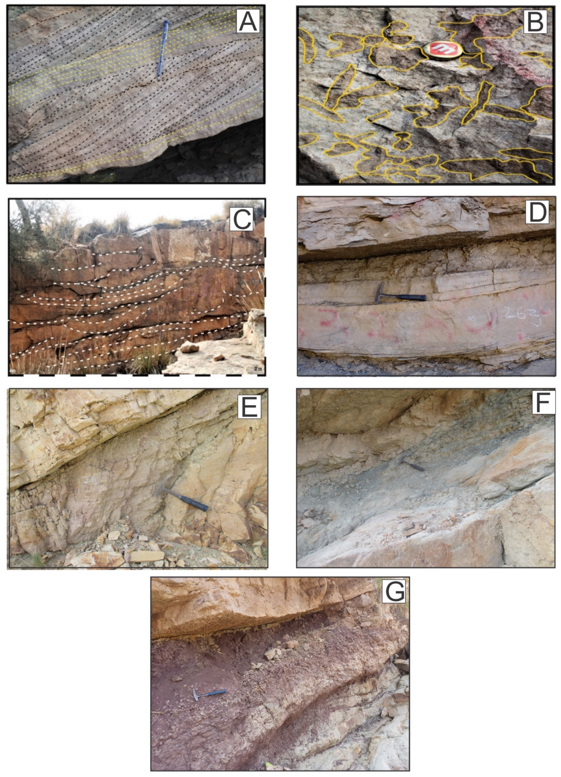
4.3. Architectural Element Analysis

Architectural element analysis is a helpful tool that goes beyond facies analysis to identify genetic facies in addition to facies analysis [25,26] (Table 2). Individuals or groups of lithofacies are divided in architectural element analysis by the bounding surfaces of various hierarchies. Based on the Pab sandstone’s sedimentary structures, geometry, paleocurrent indicators, and lateral and vertical arrangement of lithofacies, seven architectural elements were identified (Table 2).

4.3.1. Planar Cross-Bedded Sandstone Element (Scp)

Description: each architectural element of Planar cross-bedded sandstone element is bounded at its base by an erosion surface that approximates paleohorizontal, as measured relative to an underlying shale bed and sandstone beds (Figure 5A). Their upper contact is irregular with coarse-grained sandstone beds. Such an element is common all over the formation and characterized by tabular geometry, up to 2 m thick and 150 m to 200 m wide, which can be traced laterally in a few instances for distances of 250 m (Figure 6A). The element SCp consists of different sandstone facies i.e., Sn and Sp, with sub-ordinate sets of facies St, all overlain by medium-coarse grained channel facies Sm and Sch. The most abundant sedimentary structure in SCp elements is planar cross-beds, which have set thicknesses up to 0.6 m thick. In the basal part of the SCp element, the planar crossbedding is found in coarse to very-coarse grained sandstone. As they extend upward, the grain size of the sandstone becomes finer.
Interpretation: As a result of decreasing (possibly seasonal) flood events, coarse-grained, discontinuous materials accumulate as bar-top sand sheets and channel deposits [48,49]. Intercalation of coarse-grained sediments with the lithofacies Scp may reflect a rapid change in flood.

4.3.2. Trace Fossil-Sandstone Element (St)

Description: The element ST comprises facies Sb and Sp (Figure 5B). Their geometry is lobate or sheet-like. The traces are present in the medium- to coarse-grained sandstone. They are laterally extended up to 10 m and their average thickness is 1 to 2 m. The element ST have sharp erosional bases with SF overlain by Sp and Sch facies. Their upper contact is flat but erosional, with Sch facies.
The lithofacies Sb and Sch are recognized in this element. The common sedimentary structures found in element ST is traces of fossils.
Interpretation: In the case of trace fossil sandstone elements, the organism activity plays an important role in the development of this facies. Trace-sandstone elements such as Skolithos and Planolites are common in high-energy transitional marine environments [50,51,52]. Trace fossil diversity is low, in part due to high currents and sedimentation rates in tidal inlet settings [53].

4.3.3. Trough Cross-Bedded Sandstone Element (Sct)

Description: The trough crossbedding sandstone element is bounded at its base by alluvium with irregular contact and its upper contact with Sp and Sm facies in some places, while in the middle portion of the stratigraphic succession the upper contact marks the skyline (Figure 5C). It is characterized by a lenticular shape geometry, up to 3 m thick and 10 m to 20 m wide (Figure 6B). This element is mostly present in the middle of the stratigraphic succession, not present in the overall formation. The element SCt consists of different sandstone facies i.e., Sn, Sp, and St all overlain by medium coarse-grained channel facies Sch. The sedimentary structure found in the SCt element is trough crossbedding, low angle planar crossbedding, and some minor fractures. The trough crossbedding is found in medium- to coarse-grained sandstone.
Interpretation: It is believed that the element Sct results from the movement of three-dimensional dunes along channels during a low-flow regime. Their lenticular geometry, inclinations of their axes, moderate to poor sediment sorting, and scouring surfaces are indicative of the formation of troughs by migrating sinuous crested dunes [54]. While the smaller troughs were most likely formed by migrating dunes or mega ripples along with the lee sides of these bars, the larger foresets, with their progressively sloping dip and coarse-grained size, indicate deposition in low-angle bar fronts.

4.3.4. Fine Sandstone Element (Sf)

Description: The element Sf lies near the middle of the stratigraphic succession. The SF element deposits have a sheet-like geometry, reflecting their origin by vertical aggradation (Figure 5D). Their lower boundary is bounded by Sf facies with irregular-erosive contact (Figure 7A). The top surface is bounded by SCp element with flat contact and at some locations they are irregular. Characterized by sheet geometry, up to 3 feet thick and 50 m to 90 m in width. The SF element comprises lithofacies Sch, Sp, and Sm. Small-scale sedimentary structures of trace fossils are found in the SF element.
Interpretation: These laminated sand-sheet sections were deposited by non-channelized rivers. Their thin, discontinuous, sheet-like shape, along with the small-scale sedimentary formations and fine-grained lithology, supports deposition as overbank flood sand sheet. When laminae accreted vertically during sheet flooding in an upper flow regime, they were deposited in the shallower sections of channels [55].

4.3.5. Channel Deposit Element (Ch)

Description: The channel deposit element is bounded at its basal contact by a sharp erosional boundary, and the top of the channel fill may be erosional or gradational with the Sn facies (Figure 5E). It is characterized by tabular geometry (Figure 7B). The CH element is up to 0.30 m thick and 10 m to 50 m wide. The element CH is present between the Sp and St facies. The CH element comprises the lithofacies Sch, Sn, and Sh. Cavities and nodular sedimentary structures are found in the CH element.
Interpretation: The presence of coarse-grained conglomerates may suggest a sudden increase in the velocity of the depositional current. This is often done by correlating closely spaced outcrop or subsurface sections, but since most deposits include a hierarchical network of channels of different sizes, such correlation may be difficult or impossible [55]. In the Pab Formation, the Ch element is filled by the lithofacies Sp, Sm, Sch, and Sh.

4.3.6. Laminated Shale Sheet Element (Ls)

Description: Laminated shale sheet element is found all over the study section (Pab Formation). These are the small-scale shale units interbedded in a sandstone (Figure 5F). Their lateral extension is up to 10 m and the average thickness is about 0.05 m up to 0.4 m The geometry of the LS element is tabular in between the Sp, St, and Sm facies (Figure 7C). The base contact is sharp with Sm facies, while at some places the lower contact is with gradational to paleosol Pf facies, and the top contact is also sharp with Sm and Sp facies. The Sn and Sm facies are associated with this element. The fissility sedimentary structure is well recognized in the LS element.
Interpretation: The fine laminated shale element is associated with the lateral extension of the bars [56]. These elements and associated facies are attributed to deposit in channels associated high energy environment [57]. However, these types of lithologies can also form in sheet floods [58]. In the channels and associated deposits these lithologies can occur as bar flank sheet deposits [59].

4.3.7. Paleosol Element (Pa)

Description: The paleosol element is found at the starting point of the Pab Formation and in the middle portion of the study area (Pab Formation) (Figure 5G). The thickness is varying from place to place, at the starting point, the thickness is more than that of the middle portion (Figure 8A). At the starting point, they are up to 2 m thick, while in the middle portion the thickness is reduced up to 0.6 m. The geometry of the Pa element is lobate, tabular-like. Their basal contact is the erosional boundary with the cretaceous Mughal Kot Formation at the starting point, while in the middle the contact is with the Sh and Sm facies. The top surface is bounded by Sm, Sh, and Sp facies. The rootlet’s sedimentary structure is found in paleosol elements.
Interpretation: Paleosols are developed in floodplain units at the top of channel belts and stacked channel-belt complexes [60]. The preservation of shrink–swell features suggests that the paleosol developed under conditions of repeated wetting–drying cycles in a climate characterized by seasonal precipitation [61]. Abundant iron-oxide concentrations, iron-oxide coated grains and cross-cutting relationships indicating iron-oxide concentrations are secondary and likely formed during shallow burial. The dominance of clay content and the absence of large number carbonate nodules suggests that the paleosol formed on a well-drained floodplain without prolonged periods of aridity [62].

5. Discussion

5.1. Facies Association

In the Rakhi Gorge section of the Pab Formation, five facies’ relationships were observed. These facies are connected to one another based on their genetic and lithological similarities.

5.1.1. Fluvio-Deltaic Facies Associations

The Pab Formation contains facies that are associated with the fluvio-deltaic facies. The fluvio-deltaic facies association includes the Nodular sandstone facies (Sn). The fluvio-deltaic facies are characterized by the presence of large-scale sedimentary structures such as trough cross-bedded, cross-laminated, and hummocky sandstone, as well as bioturbated sandstone. These facies suggest that they were formed under conditions of strong tractional energy that varied from constant to periodic and are commonly found in settings ranging from deltaic to high-energy settings [63] (Figure 8A).

5.1.2. Shelfal Delta Lobe Facies Association

The predominant facies in this association are thick, massive sandstones, as well as bioturbated sandstones, hummocky sandstone, and mudstone. They include thick-bedded sandstone facies, coarse-grained sandstone with planar cross-bedding facies, thin bedded claystone facies. It has been proposed that these facies were deposited under a fair weather wave-base or storm wave base on the outer shelf, and most likely originated from a sand-rich delta [64]. These facies display characteristics of both shelfal delta lobe and flood-associated delta-front sandstones, as noted by Mutti et al. [65] (Figure 8B).

5.1.3. Delta Front Facies Association

The facies association includes thin-medium bedded shale facies (Sh), they are characterizing by thin- to medium-bedded shale. They also consist of some mudstone. The shales are bioturbated with no preserved sedimentary structures. These facies are usually sandwiched between the thick, massive sandstones consisting of hummocky sandstone beds [66]. These facies associations were deposited under fair weather wave base and quite environment, and the massive sandstones are the distal equivalent of the delta-front unit. It is likely that the source of these deposits was a suspension fall out from flood [67] (Figure 8C).

5.1.4. Channels Facies Association

These facies include the sandstone with channel deposit facies (Cf) and are composed of thick bedded, coarse-grained sandstone, with channelized sandstone deposits being a prominent feature. In some areas, the sandstone occurs in a lenticular shape. At the boundary between the sandstone and finer lithologies such as shale, sole marks such as grooves, flutes, and load casts are widespread. Poorly graded sandstone beds are common. Thick sandstone beds are common, with pinching and thinning occurring and being separated by intercalated fine mudstone. Mud clasts inclusions are abundant in these facies. The highly deformed sandstone beds in certain areas suggest the collapse of the channel margin. Based on the overall characteristics and features of these associated facies, it is believed that they were deposited in a channel by a high-density turbidity current [68] (Figure 8D).

5.1.5. Shore Face Facies Association

These facies association consist of the coarse sandstone with trough cross bed facies (Stc) and sandstone with bioturbation (Sb). These facies association of the shore face environment includes large-scale planar cross-bedded sandstones, trough cross-bedded sandstones, massive sandstones, bioturbated sandstones, and hummocky sandstones. The characteristics of these facies suggest that they were deposited in a high-energy fluvial deltaic environment. The presence of hummocky bedforms indicates the influence of storms [68] (Figure 8E).

5.2. Depositional Model

The Pab Formation was deposited on the western, northwest side of the Indian Plate. The early collision between the Indian plate and the Afghan block is when the Cretaceous and Eocene series emerged. Tertiary age deposits were created during the collision of the Indian plate with the Laurasian plate, and during that time transgressions and regressions were also seen [69,70]. The distribution and internal characteristics of the facies association and associated architectural elements (e.g., fluvio-deltaic facies, channel deposits facies) show that the Pab Formation belongs to a fluvio-deltaic dominated environment. The depositional environment, based on the observed lithofacies, was perceived as a fluvial deltaic. The depositional model for Pab Formation in the Rakhi Gorge section is shown in (Figure 9B). A total of nine architectural lithofacies were established in the Pab Formation. The high proportion of coarse sediments compares to the fluvial sedimentation, while the Paleosol facies demonstrate the arid climate. The Pab sandstones are a remarkably lower flow regime than some facies (facies Sp, St). The interpretation of different sedimentary structures within facies (facies Sp, St, and Sb) are confirmed as a point bar sequence. The base lithological units have channeled deposits that interpret the inner channel bends. The fine sandstone facies (facies Sf) interpret the deep-sea environment. The associations of seven architectural elements also provide a good clue about the environment of high sinuosity fluvial to the deltaic environment. At the base of these, all lithofacies and architectural elements and various sedimentary structures demonstrate a fluvio-deltaic environment.

6. Conclusions

Based on a field experiment in the Maastrichtian Pab Formation, this study proposed a methodology for evaluating architectural elements and facies. The studied sandstone deposits at the base of the Miall classification system are classified by nine lithofacies (Pf, Sch, Cf, Sh, St, Sn, Sp, Stc and Sb). The lithofacies Sp, St, and Sn indicate that the succession was deposited during a lower flow regime, but the lithofacies Sm and Sb indicate a deltaic environment. The intercalation of a few thin strata of shale, denoted by facies Sh, indicates a deep to semi-deep lake sedimentary setting. The channel deposits (Sch facies) near the base of the Pab Formation suggest that these facies were deposited in a flowing-water and deltaic environment. The distinct types of seven architectural elements (SCp, ST, SCt, CH, LS, and Pa) were identified, with their respective geometries and vertical facies correlations. These multistory sandstone structures complement the fluvio-deltaic setting. The lateral study of channelized sandstone indicates the rapid migration and expansion of point bars and channels. The pattern of coarsening facies associations is one of the distinguishing features of a deltaic environment. The various sedimentary features, such as Fe rusting, nodules, and fractures, suggest subaerial exposure. The associated facies characteristics indicate that the formation’s fluvio-deltaic origin can be inferred from examinations of its facies.

Author Contributions

M.M.; Conceptualization, Field work, writing—original draft preparation, A.A.N.; methodology, M.S.; validation, J.u.R., Resources.; G.K. and H.T.J.; formal analysis and writing—review and editing, E.U.K., H.T.J., G.K. and A.A.; statistical analysis and data curation, I.K. and A.u.R.; Visualization, editing, S.M.S., administration. All authors have read and agreed to the published version of the manuscript.

Funding

This research received no external funding.

Institutional Review Board Statement

Not applicable.

Informed Consent Statement

Not Applicable.

Data Availability Statement

The data used in this work is available on request to the corresponding author(s).

Acknowledgments

The authors acknowledge Department of Earth Sciences, Quaid-e-Azam University for providing necessary support for this research.

Conflicts of Interest

The authors declare no conflict of interest (financial or non-financial).

References

  1. Ali, S.K.; Janjuhah, H.T.; Shahzad, S.M.; Kontakiotis, G.; Saleem, M.H.; Khan, U.; Zarkogiannis, S.D.; Makri, P.; Antonarakou, A. Depositional Sedimentary Facies, Stratigraphic Control, Paleoecological Constraints, and Paleogeographic Reconstruction of Late Permian Chhidru Formation (Western Salt Range, Pakistan). J. Mar. Sci. Eng. 2021, 9, 1372. [Google Scholar] [CrossRef]
  2. Ghazi, S.; Mountney, N.P. Facies and architectural element analysis of a meandering fluvial succession: The Permian Warchha Sandstone, Salt Range, Pakistan. Sediment. Geol. 2009, 221, 99–126. [Google Scholar] [CrossRef]
  3. Miall, A. The Geology of Fluvial Sediments; Springer: Berlin, Germany, 1996. [Google Scholar]
  4. Zang, D.; Bao, Z.; Li, M.; Fu, P.; Li, M.; Niu, B.; Li, Z.; Zhang, L.; Wei, M.; Dou, L.; et al. Sandbody architecture analysis of braided river reservoirs and their significance for remaining oil distribution: A case study based on a new outcrop in the Songliao Basin, Northeast China. Energy Explor. Exploit. 2020, 38, 2231–2251. [Google Scholar] [CrossRef]
  5. Khan, M.; Ghazi, S.; Mehmood, M.; Yazdi, A.; Naseem, A.A.; Serwar, U.; Zaheer, A.; Ullah, H. Sedimentological and provenance analysis of the Cretaceous Moro formation Rakhi Gorge, Eastern Sulaiman Range, Pakistan. Iran. J. Earth Sci. 2021, 13, 251–265. [Google Scholar]
  6. Euzen, T.; Eschard, R.; Albouy, E.; Deschamps, R. Reservoir architecture of a turbidite channel complex in the Pab Formation, Pakistan; AAPG Studies in Geology 56: Atlas of Deep-Water Outcrops: Tulsa, OK, USA, 2007; Chapter 139. [Google Scholar] [CrossRef]
  7. Mehmood, M.; Ghazi, S.; Naseem, A.A.; Yaseen, M.; Dar, Q.U.Z.; Khan, M.J.; Sarwar, U.; Zaheer, A. Petrofacies investigations of the Cretaceous Pab Formation Rakhi Gorge Eastern Sulaiman Range Pakistan—Implication for reservoir potential. Bull. Geol. Soc. Malays. 2021, 72, 37–46. [Google Scholar] [CrossRef]
  8. Umar, M.; Friis, H.; Khan, A.S.; Kassi, A.M.; Kasi, A.K. The effects of diagenesis on the reservoir characters in sandstones of the Late Cretaceous Pab Formation, Kirthar Fold Belt, southern Pakistan. J. Asian Earth Sci. 2011, 40, 622–635. [Google Scholar] [CrossRef]
  9. Reynolds, K.; Copley, A.; Hussain, E. Evolution and dynamics of a fold-thrust belt: The Sulaiman Range of Pakistan. Geophys. J. Int. 2015, 201, 683–710. [Google Scholar] [CrossRef]
  10. Stein, S.; Sella, G.; Okal, E.A. The January 26, 2001 Bhuj Earthquake and the Diffuse Western Boundary of the Indian Plate, in Plate Boundary Zones; AGU: Washington, DC, USA, 2002; pp. 243–254. [Google Scholar]
  11. Szeliga, W.; Bilham, R.; Kakar, D.M.; Lodi, S.H. Interseismic strain accumulation along the western boundary of the Indian subcontinent. J. Geophys. Res. Atmos. 2012, 117. [Google Scholar] [CrossRef]
  12. Vernant, P.; Nilforoushan, F.; Hatzfeld, D.; Abbassi, M.R.; Vigny, C.; Masson, F.; Nankali, H.; Martinod, J.; Ashtiani, A.; Bayer, R.; et al. Present-day crustal deformation and plate kinematics in the Middle East constrained by GPS measurements in Iran and northern Oman. Geophys. J. Int. 2004, 157, 381–398. [Google Scholar] [CrossRef]
  13. Kassi, A.M.; Kelling, G.; Kasi, A.K.; Umar, M.; Khan, A.S. Contrasting Late Cretaceous–Palaeocene lithostratigraphic successions across the Bibai Thrust, western Sulaiman Fold–Thrust Belt, Pakistan: Their significance in deciphering the early-collisional history of the NW Indian Plate margin. J. Asian Earth Sci. 2009, 35, 435–444. [Google Scholar] [CrossRef]
  14. Ghazi, A.; Hafezi Moghadas, N.; Sadeghi, H.; Ghafoori, M.; Lashkaripour, G. The effect of geomorphology on engineering geology properties of alluvial deposits in Mashhad City. Sci. Q. J. Geosci. 2015, 24, 17–28. [Google Scholar]
  15. Vredenburg, E.W. Report on the Geology of Sarawan, Jhalawan, Mekran and the State of Las Bela, Considered Principally from the Point of View of Economic Development. Rec. Geol. Surv. India 1909, 3, 189–215. [Google Scholar]
  16. Miall, A.D. Facies architecture in clastic sedimentary basins. In New Perspectives in Basin Analysis; Springer: New York, NY, USA, 1988; pp. 67–81. [Google Scholar]
  17. Miall, A.D. In defense of facies classifications and models. J. Sediment. Res. 1999, 69, 2–5. [Google Scholar] [CrossRef]
  18. Miall, A.D. Fluvial Depositional Systems; Springer International Publishing: Cham, Switzerland, 2014; Volume 14, p. 316. [Google Scholar]
  19. Farrell, K.M.; Harris, W.B.; Mallinson, D.J.; Culver, S.J.; Riggs, S.R.; Pierson, J.; Self-Trail, J.M.; Lautier, J.C. Standardizing Texture and Facies Codes for A Process-Based Classification of Clastic Sediment and Rock. J. Sediment. Res. 2012, 82, 364–378. [Google Scholar] [CrossRef]
  20. Dickinson, W.R. Interpreting Provenance Relations from Detrital Modes of Sandstones. In Provenance of Arenites; Springer: Dordrecht, The Netherlands, 1985; pp. 333–361. [Google Scholar] [CrossRef]
  21. Ghazi, S.; Mountney, N.P.; Sharif, S. Lower Permian fluvial cyclicity and stratigraphic evolution of the northern margin of Gondwanaland: Warchha Sandstone, Salt Range, Pakistan. J. Asian Earth Sci. 2015, 105, 1–17. [Google Scholar] [CrossRef]
  22. McBride, E.F. A Classification of Common Sandstones. J. Sediment. Res. 1963, 33. [Google Scholar] [CrossRef]
  23. Miall, A.D. Architectural-element analysis: A new method of facies analysis applied to fluvial deposits. Earth-Sci. Rev. 1985, 22, 261–308. [Google Scholar] [CrossRef]
  24. Gustavson, T.C. Arid Basin Depositional System and Paleosol: Fort Hancock and Camp Rice Formation (Pliocene-Pleistocene), Hueco Bolson, West Texas and adjacent Mexico; Report of Investigation; Bureau of Economic Geology, Exploration Way: Austin, TX, USA, 1991; p. 198. [Google Scholar]
  25. Retallack, G.J. Scoyenia burrows from Ordovician palaeosols of the Juniata Formation in Pennsylvania. Palaeontology 2001, 44, 209–235. [Google Scholar] [CrossRef]
  26. Li, J.; Wen, X.; Huang, C. Lower Cretaceous paleosols and paleoclimate in Sichuan Basin, China. Cretac. Res. 2016, 62, 154–171. [Google Scholar] [CrossRef]
  27. Tabor, N.J.; Myers, T.S.; Michel, L.A. Sedimentologist’s guide for recognition, description, and classification of paleosols. In Terrestrial Depositional Systems; Elsevier: Amsterdam, The Netherlands, 2017; pp. 165–208. [Google Scholar]
  28. Malaza, N.; Liu, K.; Zhao, B. Facies Analysis and Depositional Environments of the Late Palaeozoic Coal-Bearing Madzaringwe Formation in the Tshipise-Pafuri Basin, South Africa. ISRN Geol. 2013, 2013, 120380. [Google Scholar] [CrossRef]
  29. Mayall, M.; Jones, E.; Casey, M. Turbidite channel reservoirs—Key elements in facies prediction and effective development. Mar. Pet. Geol. 2006, 23, 821–841. [Google Scholar] [CrossRef]
  30. Schumm, S.A. Evolution and Response of the Fluvial System, Sedimentologic Implications; SEPM: Broken Arrow, OK, USA, 1981; pp. 19–29. [Google Scholar] [CrossRef]
  31. Allen, J.R.L. Studies in fluviatile sedimentation: A comparison of fining upwards cyclothems, with particular reference to coarse member composition and interpretation. J. Sediment. Petrol. 1970, 40, 298–323. [Google Scholar]
  32. Collinson, J.D. Alluvial Sediments, In Sedimentary Environments and Facies, 3rd ed.; Reading, H.G., Ed.; Blackwell Publishing: Oxford, UK, 1996; pp. 37–82. [Google Scholar]
  33. Jackson II, R.G. Sedimentology of muddy fine-grained channel deposits in meandering streams of the American Middle West. J. Sediment. Petrol. 1981, 51, 1169–1192. [Google Scholar]
  34. Hjellbakk, A. Facies and fluvial architecture of a high-energy braided river: The Upper Proterozoic Seglodden Member, Varanger Peninsula, northern Norway. Sediment. Geol. 1997, 114, 131–161. [Google Scholar] [CrossRef]
  35. Ghazi, S.; Mountney, N.P. Subsurface lithofacies analysis of the fluvial early permian Warchha Sandstone, Potwar Basin, Pakistan. J. Geol. Soc. India 2010, 76, 505–517. [Google Scholar] [CrossRef]
  36. Walker, R.G. Facies models and modern stratigraphic concepts. In Facies Models: Response to Sea-level Change; Walker, R.G., James, N.P., Eds.; Geological Asociation of Canada: St. John’s, NL, Canada, 1992; pp. 1–14. [Google Scholar]
  37. Kingsley, C.S. Stratigraphy and Sedimentology of the Ecca Group in the Eastern Cape Province, South Africa. Ph.D. Thesis, University of Port Elizabeth, Port Elizabeth, South Africa, 1977; p. 290. [Google Scholar]
  38. Jamil, M.; Siddiqui, N.A.; Rahman, A.H.B.A.; Ibrahim, N.A.; Ismail, M.S.B.; Ahmed, N.; Usman, M.; Gul, Z.; Imran, Q.S. Facies Heterogeneity and Lobe Facies Multiscale Analysis of Deep-Marine Sand-Shale Complexity in the West Crocker Formation of Sabah Basin, NW Borneo. Appl. Sci. 2021, 11, 5513. [Google Scholar] [CrossRef]
  39. Bhattacharya, J.P.; Miall, A.D.; Ferron, C.; Gabriel, J.; Randazzo, N.; Kynaston, D.; Jicha, B.R.; Singer, B.S. Time-stratigraphy in point sourced river deltas: Application to sediment budgets, shelf construction, and paleo-storm records. Earth Sci. Rev. 2019, 199, 102985. [Google Scholar] [CrossRef]
  40. Arnot, M.J.; Browne, G.H.; King, P.R. Thick-bedded Sandstone Facies in a Middle Basin-floor-fan Setting; Mount Messenger Formation: Mohakatino Beach, New Zealand, 2007. [Google Scholar]
  41. Jones, B.G.; Rust, B.R. Massive sandstone facies in the Hawkesbury Sandstone, a Triassic fluvial deposit near Sydney, Australia. J. Sediment. Res. 1983, 53, 1249–1259. [Google Scholar]
  42. Fisher, W.L.; Galloway, W.E.; Steel, R.J.; Olariu, C.; Kerans, C.; Mohrig, D. Deep-water depositional systems supplied by shelf-incising submarine canyons: Recognition and significance in the geologic record. Earth Sci. Rev. 2021, 214, 103531. [Google Scholar] [CrossRef]
  43. Stow, D.A.; Hernández-Molina, F.J.; Llave, E.; Sayago-Gil, M.; Del Río, V.D.; Branson, A. Bedform-velocity matrix: The estimation of bottom current velocity from bedform observations. Geology 2009, 37, 327–330. [Google Scholar] [CrossRef]
  44. Selim, S.; El-Gwad, M.A.; Abu Khadrah, A. Sedimentology, petrography, hydraulic flow units, and reservoir quality of the bayhead delta reservoirs: Late Messinian Qawasim formation, Nile Delta, Egypt. Mar. Pet. Geol. 2021, 130, 105125. [Google Scholar] [CrossRef]
  45. Boulesteix, K.; Poyatos-More, M.; Flint, S.S.; Hodgson, D.M.; Taylor, K.G.; Parry, G.R. Sedimentary facies and stratigraphic architecture of deep-water mudstones beyond the basin-floor fan sandstone pinchout. J. Sediment. Res. 2020, 90, 1678–1705. [Google Scholar] [CrossRef]
  46. Aigbadon, G.O.; Akakuru, O.C.; Chinyem, F.I.; Akudo, E.O.; Musa, K.O.; Obasi, I.A.; Overare, B.; Ocheli, A.; Sanni, Z.J.; Bala, J.A., II. Facies analysis and sedimentology of the Campanian–Maastrichtian sediments, southern Bida Basin, Nigeria. Carbonates Evaporites 2023, 38, 27. [Google Scholar] [CrossRef]
  47. Nichols, G. Sedimentology and Stratigraphy; John Wiley & Sons: Hoboken, NJ, USA, 2009. [Google Scholar]
  48. Finthan, B.; Mamman, Y.D. The lithofacies and depositional paleoenvironment of the Bima Sandstone in Girei and Environs, Yola Arm, Upper Benue Trough, Northeastern Nigeria. J. Afr. Earth Sci. 2020, 169, 103863. [Google Scholar] [CrossRef]
  49. Dar, Q.U.Z.; Renhai, P.; Ghazi, S.; Ahmed, S.; Ali, R.I.; Mehmood, M. Depositional facies and reservoir characteristics of the Early Cretaceous Lower Goru Formation, Lower Indus Basin Pakistan: Integration of petrographic and gamma-ray log analysis. Petroleum 2021. [Google Scholar] [CrossRef]
  50. Eschard, R.; Albouy, E.; Gaumet, F.; Ayub, A. Comparing basin floor fan versus slope fan depositional architecture in the Pab sandstone, Maastrichtian, Pakistan. Geol. Soc. Lond. Spec. Publ. 2002, 222, 159–185. [Google Scholar] [CrossRef]
  51. Wang, C.-Z.; Wang, J.; Hu, B.; Lu, X.-H. Trace fossils and sedimentary environments of the upper cretaceous in the Xixia Basin, Southwestern Henan Province, China. Geodin. Acta 2016, 28, 53–70. [Google Scholar] [CrossRef]
  52. Okoro, A.U.; Igwe, E.O.; Umo, I.A. Sedimentary facies, paleoenvironments and reservoir potential of the Afikpo Sandstone on Macgregor Hill area in the Afikpo Sub-basin, southeastern Nigeria. SN Appl. Sci. 2020, 2, 1–17. [Google Scholar] [CrossRef]
  53. Ali, S.; Gingras, M.K.; Wilson, B.; Winter, R.; Gunness, T.; Wells, M. The influence of bioturbation on reservoir quality: Insights from the Columbus Basin, offshore Trinidad. Mar. Pet. Geol. 2023, 147, 105983. [Google Scholar] [CrossRef]
  54. Stow, D.; Nicholson, U.; Kearsey, S.; Tatum, D.; Gardiner, A.; Ghabra, A.; Jaweesh, M. The Pliocene-Recent Euphrates river system: Sediment facies and architecture as an analogue for subsurface reservoirs. Energy Geosci. 2020, 1, 174–193. [Google Scholar] [CrossRef]
  55. Coronel, M.D.; Isla, M.F.; Veiga, G.D.; Mountney, N.P.; Colombera, L. Anatomy and facies distribution of terminal lobes in ephemeral fluvial successions: Jurassic Tordillo Formation, Neuquén Basin, Argentina. Sedimentology 2020, 67, 2596–2624. [Google Scholar] [CrossRef]
  56. Bjerstedt, T.W. Trace fossils from the early Mississippian price delta, southeast west Virginia. J. Paleontol. 1988, 62, 506–519. [Google Scholar]
  57. Amireh, B.; Schneider, W.; Abed, A. Fluvial-shallow marine-glaciofluvial depositional environments of the Ordovician System in Jordan. J. Asian Earth Sci. 2001, 19, 45–60. [Google Scholar] [CrossRef]
  58. Fielding, C.R. Upper flow regime sheets, lenses and scour fills: Extending the range of architectural elements for fluvial sediment bodies. Sediment. Geol. 2006, 190, 227–240. [Google Scholar] [CrossRef]
  59. Maceachern, J.A.; Pemberton, S.G. Ichnological Aspects of Incised-Valley Fill Systems from the Viking Formation of the Western Canada Sedimentary Basin, Alberta, Canada. In Incised-Valley Systems: Origin and Sedimentary Sequences; SEPM Society for Sedimentary Geology: Broken Arrow, OK, USA, 1994. [Google Scholar] [CrossRef]
  60. Boggs, S. Principles of Sedimentology and Stratigraphy; Pearson: London, UK, 2012. [Google Scholar]
  61. Abdel-Fattah, Z.A. Fluvial architecture of the Upper Cretaceous Nubia Sandstones: An ancient example of sandy braided rivers in central Eastern Desert, Egypt. Sediment. Geol. 2021, 420, 105923. [Google Scholar] [CrossRef]
  62. Capuzzo, N.; Wetzel, A. Facies and Basin architectural of the late Carboniferous Salvan-Dorenaz continental basin (western Alps, Switzerland/France). Sedimentology 2004, 51, 675–697. [Google Scholar] [CrossRef]
  63. Olsen, H. The architecture of a sandy braided-meandering river system: An example from the Lower Triassic Solling Formation (M. Buntsandstein) in W Germany. Geol. Rundsch. 1988, 77, 797–814. [Google Scholar] [CrossRef]
  64. Bordy, E.M.; Head, H.; Runds, M.J. Paleoenvironment and provenance in the early Cape Basin of southwest Gondwana: Sedimentology of the lower ORDOVICIAN Piekenierskloof Formation, Cape Supergroup, South Africa. S. Afr. J. Geol. 2016, 119, 399–414. [Google Scholar] [CrossRef]
  65. Cant, D.J.; Walker, R.G. Fluvial processes and facies sequences in the sandy braided South Saskatchewan River, Canada. Sedimentology 1978, 25, 625–648. [Google Scholar] [CrossRef]
  66. Kraus, M.J. Paleosols in clastic sedimentary rocks: Their geologic applications. Earth-Sci. Rev. 1999, 47, 41–70. [Google Scholar] [CrossRef]
  67. Wilding, L.P.; Tessier, D. Genesis of Vertisols: Shrinkswell Phenomena. In Vertisols: Their Distribution, Properties, Classification and Management; Wilding, L.P., Puentes, R., Eds.; Texas A&M University Publishing Center: College Station, TX, USA, 1988; pp. 55–81. [Google Scholar]
  68. Buol, S.W.; Southard, R.J.; Graham, R.C.; Mcdaniel, P.A. Soil Genesis and Classification, 5th ed.; Iowa State University Press: Ames, Lowa, 2003; 494p. [Google Scholar]
  69. Shahzad, A.; Tan, J.; Ahsan, S.A.; Abbasi, I.A.; Shahzad, S.M. Identification of Potential Hydrocarbon Source Rocks Using Biological Markers in the Kohat-Potwar Plateaus, North Pakistan. In Proceedings of the 2022 Goldschmidt Conference, Honolulu, HI, USA, 11–15 July 2022. [Google Scholar]
  70. Khan, S.; Nisar, U.B.; Ehsan, S.A.; Farid, A.; Shahzad, S.M.; Qazi, H.H.; Khan, M.J.; Ahmed, T. Aquifer vulnerability and groundwater quality around Brahma Bahtar lesser Himalayas Pakistan. Environ. Earth Sci. 2021, 80, 454. [Google Scholar] [CrossRef]
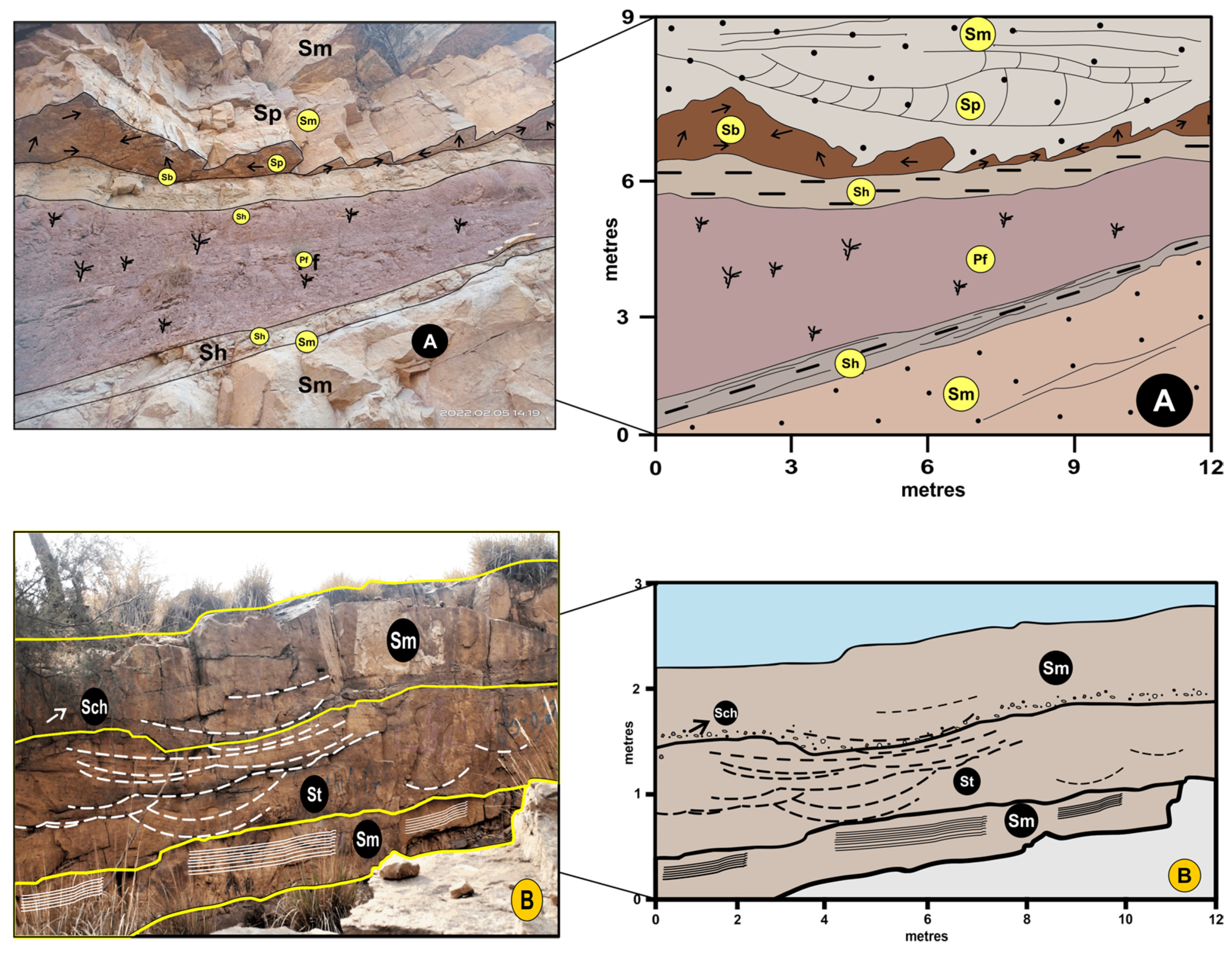
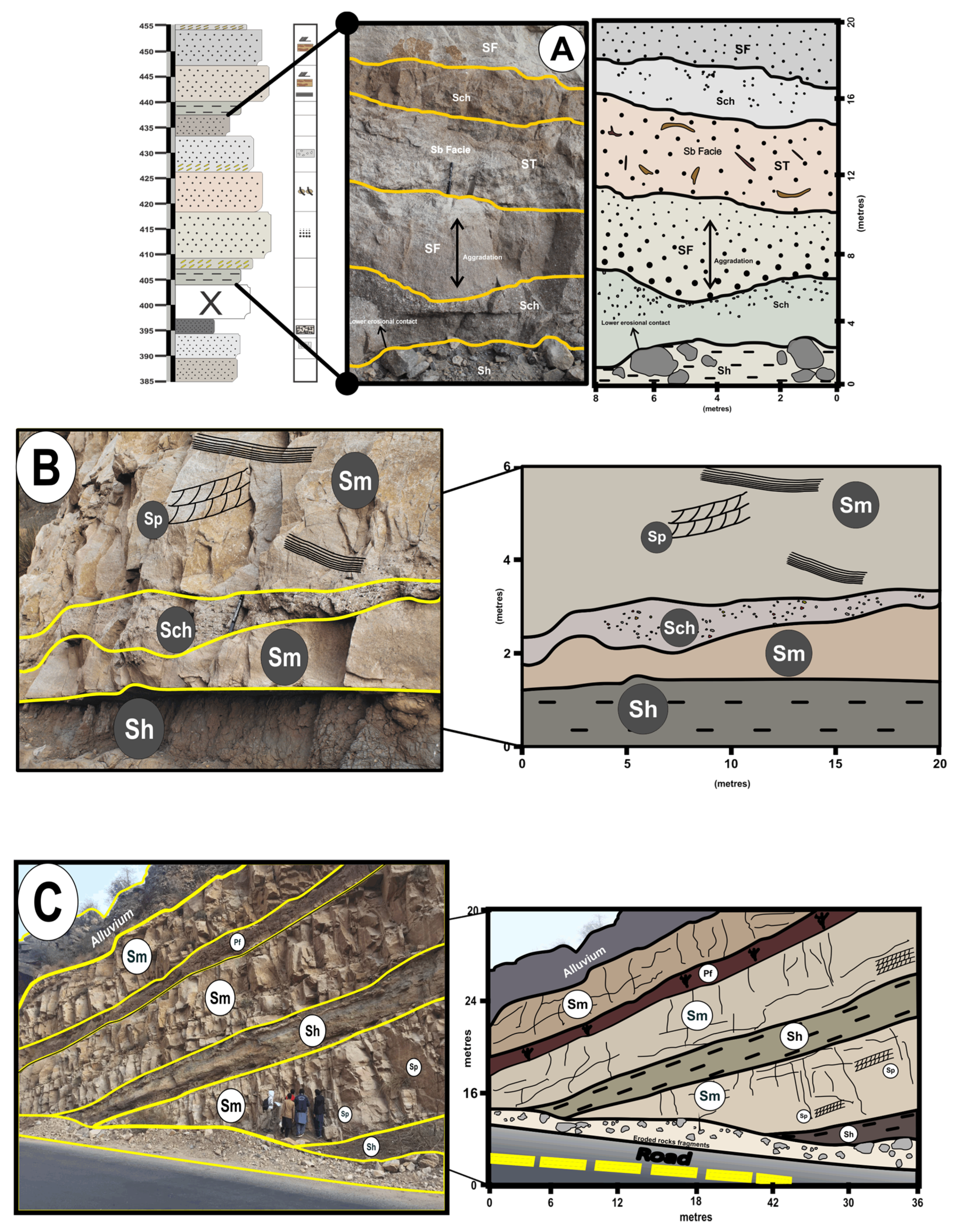
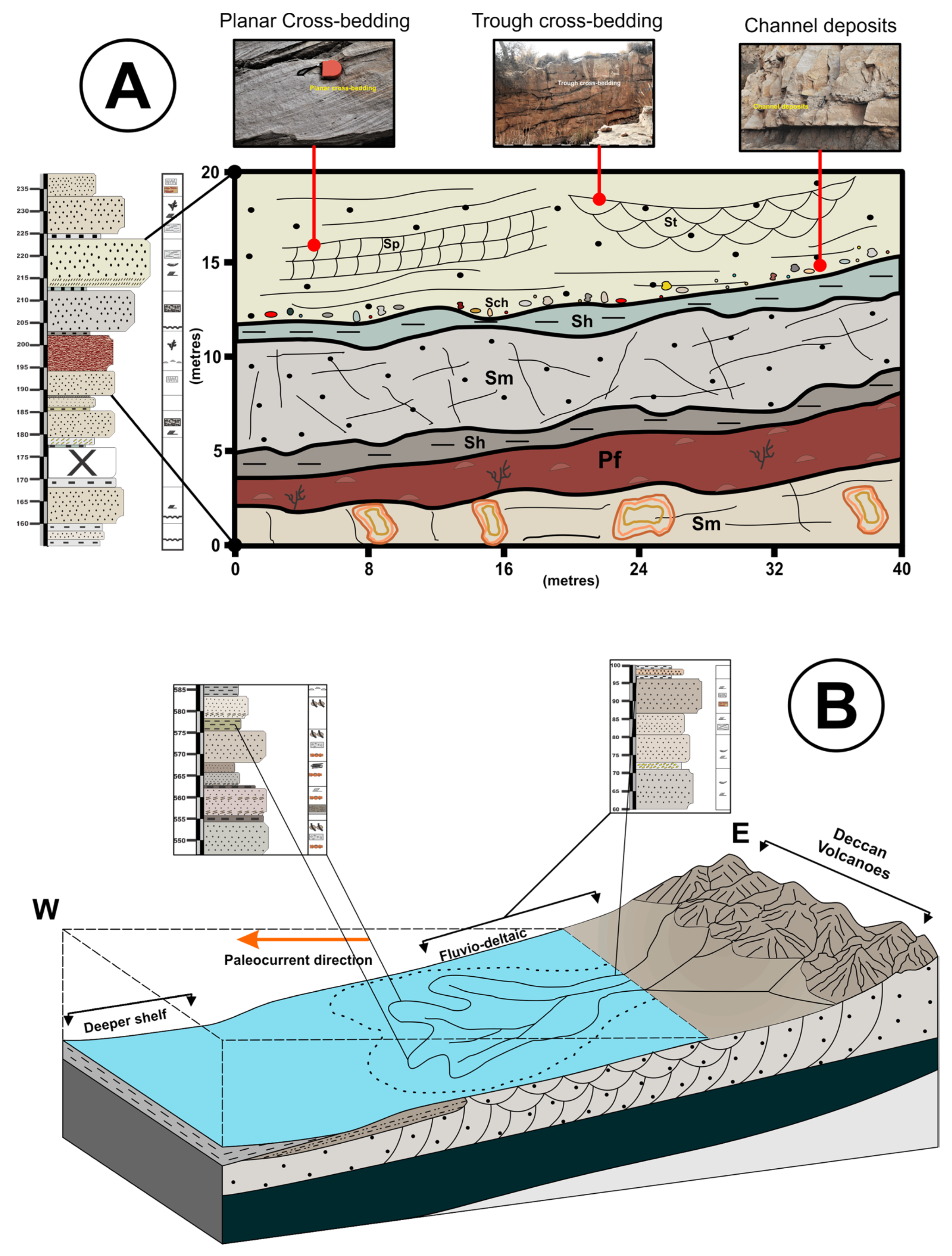
Figure 1. Map showing the outcrop belt of the Pab Sandstone in the Rakhi gorge, Eastern Sulaiman range of Pakistan, inset shows the generalized stratigraphic column.
Jmse 11 00726 g001
Figure 2. Showing the overall lithologic log of the Pab Formation in Eastern Sulaiman Ranges, the cyclic changes have been represented by the funnel shape with faded color representing fluvial and light color representing the deltaic sediments. The off-black color represents the development of a humid climate resulting in paleosol.
Jmse 11 00726 g002
Figure 4. (A) Paleosol unit in the Pab Formation and their different colors variation; (B) field photograph showing the channelized sandstone unit in Pab Formation; (C) very fine-grained claystone unit; (D) shale unit interbedded in sandstone; (E) and (F) massive bedding sandstone unit; (G) nodules in sandstone; (H) and (I) planar cross-bedded sandstone; (J) large-scale trough cross-bedded sandstone; and (K) and (L) trace fossils and bioturbation in Pab Formation.
Jmse 11 00726 g004
Figure 5. (A) Planar cross-bedded sandstone element; (B) trace fossil sandstone element; (C) trough cross-bedded sandstone element; (D) fine sandstone element; (E) channel fill deposit element; (F) laminated shale sheet element; (G) Paleosol element.
Jmse 11 00726 g005
Figure 6. (A) Field sketch showing Planar cross-bedding element (SCp) and traces sandstone element (ST), asymmetrically filled with facies Sb, Pf, Sm, and Sh in Pab Formation. Arrows show the bioturbation in the Sb facies and heavy lines delineate the facies boundaries; and (B) photomosaic of trough cross-bedding element (SCt) in the middle part of the study area. This element is filled with facies Sm, St, and Sch in the Pab Formation. Heavy lines delineate the facies boundaries while the dashed lines show the trough crossbedding.
Jmse 11 00726 g006
Figure 7. (A) Field sketch of fined-sandstone element (SF), filled with facies Sb, Sch, and Sh in the study area. The element SF is found in the lower and middle part of the Pab Formation, in the middle portion the aggradation is found in the Sf element; (B) photomosaic of channel deposit element (CH) interbedded with coarse-grained sandstone with Sm and Sp; and (C) field sketch of laminated shale element (LS) in the middle part of the Formation. This element presents in b/w the Sm facies all over the Pab Formation and filled with facies Sp, Pf, Sm, and Sh in Pab Formation.
Jmse 11 00726 g007
Figure 8. (A) Sedimentary cross bed representing fluvio-deltaic facies; (B) highly bioturbated bed red arrow associated with shelfal delta lobe; (C) shale unit highlighted by the meter stick of the delta front; (D) load cast belonging to channels; and (E) trough cross-bedded sandstone belonging to shore face environment.
Jmse 11 00726 g008
Figure 9. (A) Generalized section depicting the Pab architectural element b/w the Sh and Sm facies. This element consists of facies Sm, Sp, St, Sch, pf, and Sh. Showing the detailed lateral and vertical facies variations; and (B) depositional model of Pab sandstone in Eastern Sulaiman Ranges, Pakistan.
Jmse 11 00726 g009
Table 1. Summary of sedimentary facies from the studied area (Pab Formation).
Grain SizeBed-ThicknessSed-StructuresDescriptionInterpret-Ation
1. Paleosol Facies (Pf)Fine soilThin to Thick bedded. From 0.30 m to 5.4 m.Rootlets, Nodular Paleosol.The Paleosol facies consists of fine-grained soil. The color of this facies is variable i.e., dark brown to rusty reddish, and in some places, the color is pale brown. Typically, the Paleosol are nodular and trace fossils of rootlets are found in this facies.These lithofacies represents soil development in a humid climate.
2. Sandstone with Channel Deposit Facies (Sch)Coarse-grained sandstone, sand-gravel size in the channel deposits.0.08 m–0.16 m width and 8 m–10 m laterally extend along the bedsChannel deposits, Liesegang rings.Channel deposits are in a layer and somewhere in the irregular form in the sandstone succession in the Pab Formation. It occurs at the base and also in the middle of sandstone beds.Channel deposits indicate running water/Channel levee complex.
3. Thin Bedded Clay stone Facies (Cf)Very fine-grained clay.Thin bedded, approximately 0.2 m to 0.4 mNoneThe clay is almost sandy. The clay beds lie between the sandstone beds. The thickness of the clay beds is mostly thin-bedded. Color is varying, from med-brown-greyish to greenish-grey.Suspension fall out/Flooding condition, overbank deposition.
4. Thin-Medium Bedded Shale Facies (Sh)Fine-grained sandy shale.Thin to medium bedded. From 0.16 m up to 0.9 m.Load cast, Fe rusting.Thin-medium bedded shale b/w the. The color of the shale is from greenish-grey to pale yellowish and in some places, the color is light brown.Deep to semi-deep sedimentary settings/overbank deposits/fills of floodplain-drainage channels
5. Thick bedded Sandstone Facies (St)Coarse to very coarse2.1 m to 3 m.Planar cross-bedding, Trough cross-bedding, Liesegang rings, post deformational fractures.Weathered color is mostly med-brown, med-greyish to med-yellowish, also pinkish beds are found. Mostly post deformational vertical and horizontal fractures. Also, iron rusting is common in Sm facies.Delta lobe
6. Nodular sandstone Beds Facies (Sn)Med-coarse grain and nodules diameter is typically 4-2-4 cm.0.25 m to 0.7 m. Nodularity/Chaotic natureNodular Sandstone is present. The Fe and chert nodules are common in this facies. color is med-brown to dark greyish brown.Slumping/sudden fall out along the margins and slope and rapid deposition.
7. Coarse-grained Sandstone with Planar Cross-Bedding Facies (Sp)Coarse to very coarse-grained size.5 m to 2.5 m.Planar cross-bedding, Liesegang rings. Irregular post deformational fractures.Consists of coarse-grained sandstone with planar crossbedding. The weathered color is varied, from dark greyish to dark brown, and at some places, the color is pinkish, while the fresh color is off-white, light greyish to pale yellow and brown.Shelfal delta lobe
8. Coarse-grained Sandstone with Trough Cross-Bedding Facies (Stc)Medium-coarse-grained sandstone.0.30 m–1 m.Trough cross-bedding, post deformational horizontal and vertical fractures.Med-Coarse grained sandstone with crossbedding. The weathered color is a pale yellow to brownish while the fresh color is light grey to off-white.Shoreface facies
9. Sandstone with bioturbation and Trace Fossils Facies (Sb)Medium to coarse-grained.0.30 m to 1.5 m.Trace fossils, Bioturbation, Fe rusting.The color of this facies is from light brown and greyish to dark brown and greenish-grey. The bed’s thickness is about from 0.30 m to 1.5 m. The bioturbation occurs at the bottom of the sandstone beds.Low-energy deltaic environment.
Table 2. Summary and generalized table of architectural element analysis from the studied area (Pab Formation).
Element
(Code)
GeometryFacies Assoc.DescriptionInterpretation
Planar Cross-Bedded Sandstone Element. (SCp)Tabular, Sheet likeSp
Sm
Sch
The SCp consisits of medium- to coarse-grained sandstone with planar cross-beds. They are pebbly and lenticular in nature. The planar cross-bedding sandstone element is abundant laterally and thegrain size of sandstone becomes finer in the upward side. They have a gradational contact with the lower beds.The intercalation of coarse-grained sediments with the lithofacies Sp may reflect a rapid change in flood regime or imply high-energy sheet floods into a lower energy environment.
Traces-Sandstone Element. (ST)Lobate and sheet-likeSb
Sp
Sch
Medium to coarse-grained, lobate geometry of ST element. They are laterally extended up to 10 m and their average thickness is 1 m to 2 m. Their upper contact is flat but erosional with Sch facies. The common sedimentary structures found in element ST is traces of fossils.The lobate geometry and traces of different fossils indicate in low-energy deltaic environment.
Trough Cross-Bedding Sandstone Element. (SCt)Lenticular geometry.St
Stc
Sch
Extended to the lower and central portion of the Formation. The trough cross-bedding element is found in medium to coarse-grained sandstone. Abundant trough cross bedding structures are commom. Low angle planar cross-bedding, and some minor fractures.SCt is interpreted as the product of three-dimensional dunes migrating in channels under lower flow regime conditions.
Fined-Sandstone Element. (SF)Sheet likeSch
Sp
Sm
The SF element is fined-grained sandstone. SF deposits have a sheet-like geometry, reflecting their origin by vertical aggradation. Trace fossils are found in the SF element.Sheet-like geometry, together with the small-scale sedimentary structures and the fine-grained lithology suggests deposition as a bar-top or bar-flank sand sheet.
Channel Deposit Element. (CH)TabularSn
Sch
Sp
The CH element is up to 0.30 m thick and 10 m to 50 m wide. The element CH is present in between the Sp and St facies. The CH element comprises lithofacies Sch and Sn. The cavities and nodular sedimentary structures are found in the CH element. They have a coarse and erosive geometry. Their upper and lower contacts are not uniform.Recognition of the CH element in a fluvial deposit depends on the ability to define the sloping channel margins. The presence of coarse-grained conglomerates may designate a sudden increase in the velocity of the depositional current.
Laminated Shale Sheet Element. (LS)Tabular, lobate-like.Sn
Sh
The LS element is interbedded in the sandstone unit. Their lateral extension is up to 10 m and the average thickness is about 0.05 m up to 0.45 m. Having a deformational upper and lower contact. Abundant ball and socket structures at the upper contact.Deep to semi-deep lake sedimentary settings are where shale element emerges.
Paleosol Element. (Pa)TabularSn
Sb
The fine-grained paleosol element has lobate and tabular shape geometry. They are present in the upper and lower part of the Formation. Thay exhibit a variable geometry and thickness. Thicness is from 0.60 m to 5.4 m thick Sedimentary structures includes rootlets and cone and cone structures.This element interpreted soil development in a humid climate.
Disclaimer/Publisher’s Note: The statements, opinions and data contained in all publications are solely those of the individual author(s) and contributor(s) and not of MDPI and/or the editor(s). MDPI and/or the editor(s) disclaim responsibility for any injury to people or property resulting from any ideas, methods, instructions or products referred to in the content.

