
A Review of Unmanned Aerial Vehicles Usage as an Environmental Survey Tool within Tidal Stream Environments

 ,
,  ,
,
Abstract
:1. Introduction
2. Advantages and Limitations of Multirotor Unmanned Aerial Vehicle Usage
2.1. Background
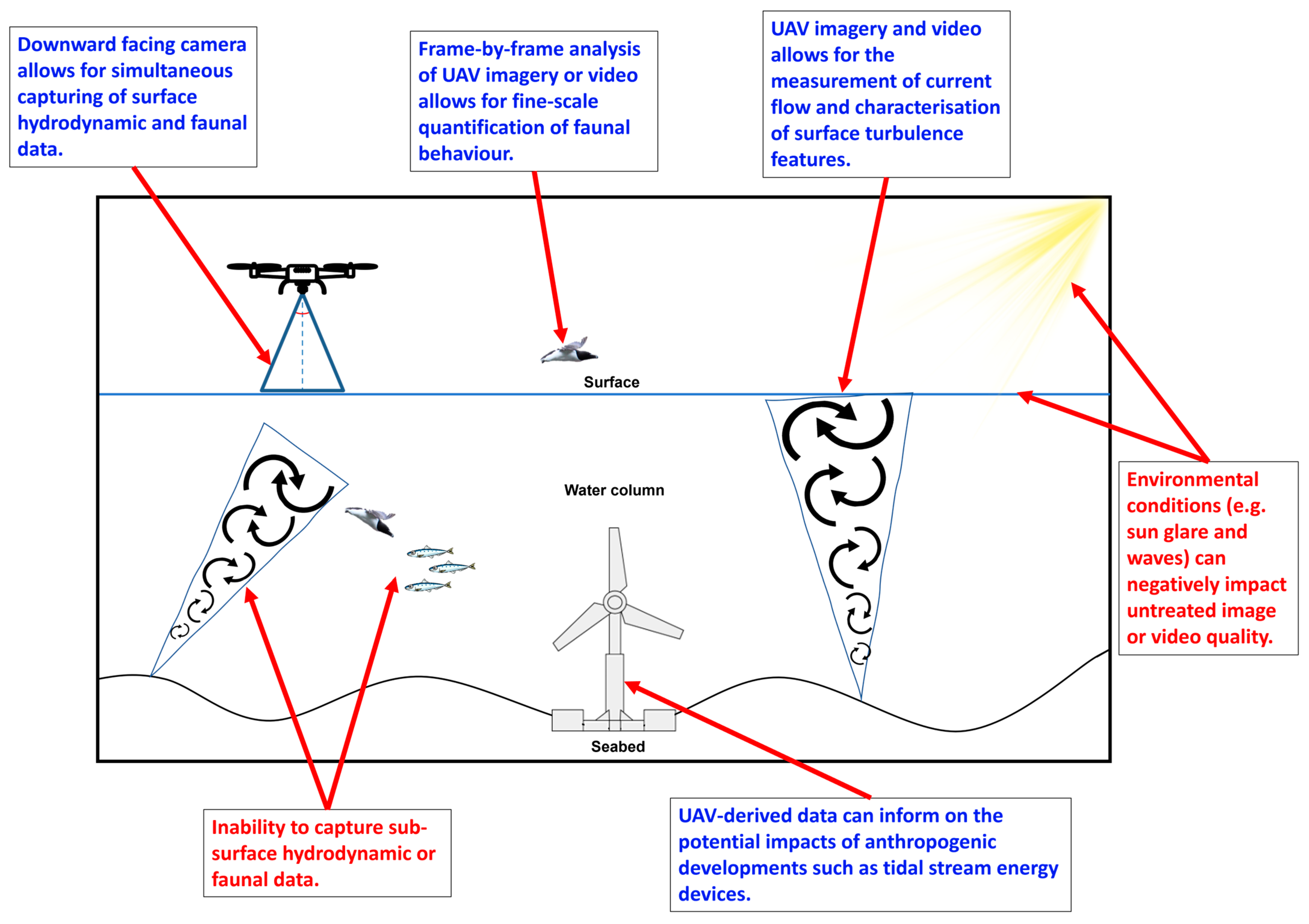
2.2. Advantages
2.3. Limitations
3. Complementary Image Processing and Automation Techniques
3.1. Background
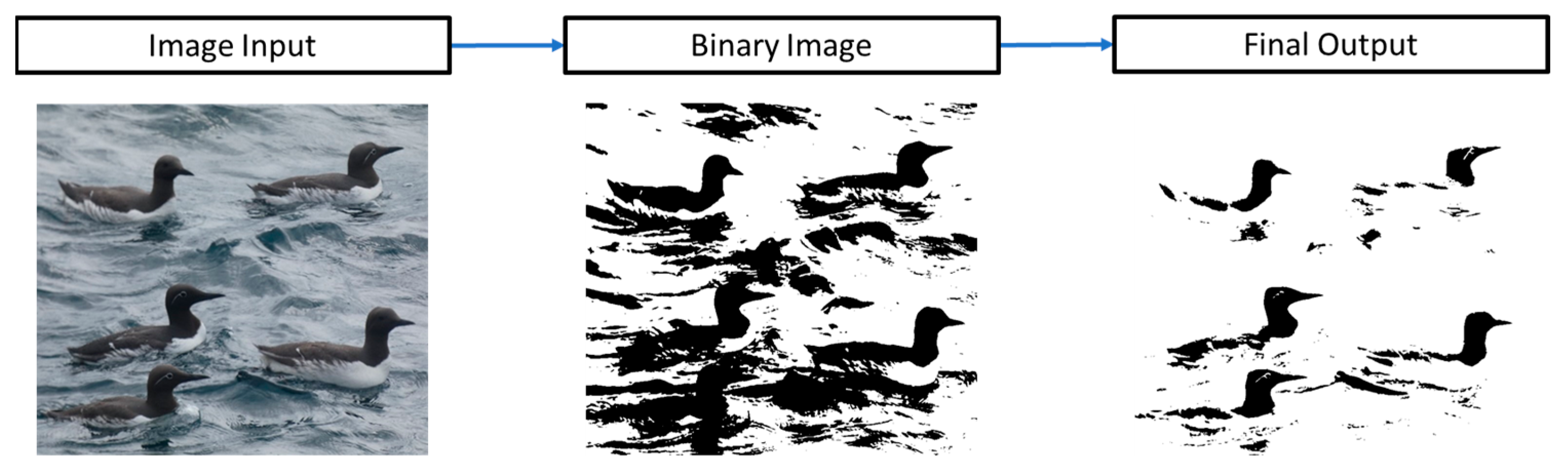
3.2. Image Segmentation and Thresholding
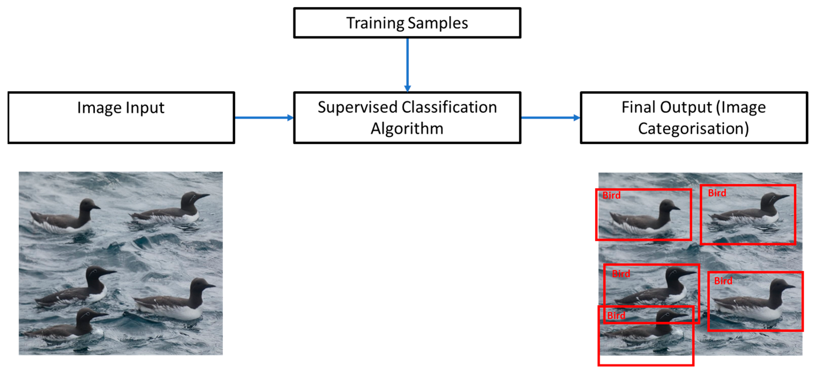
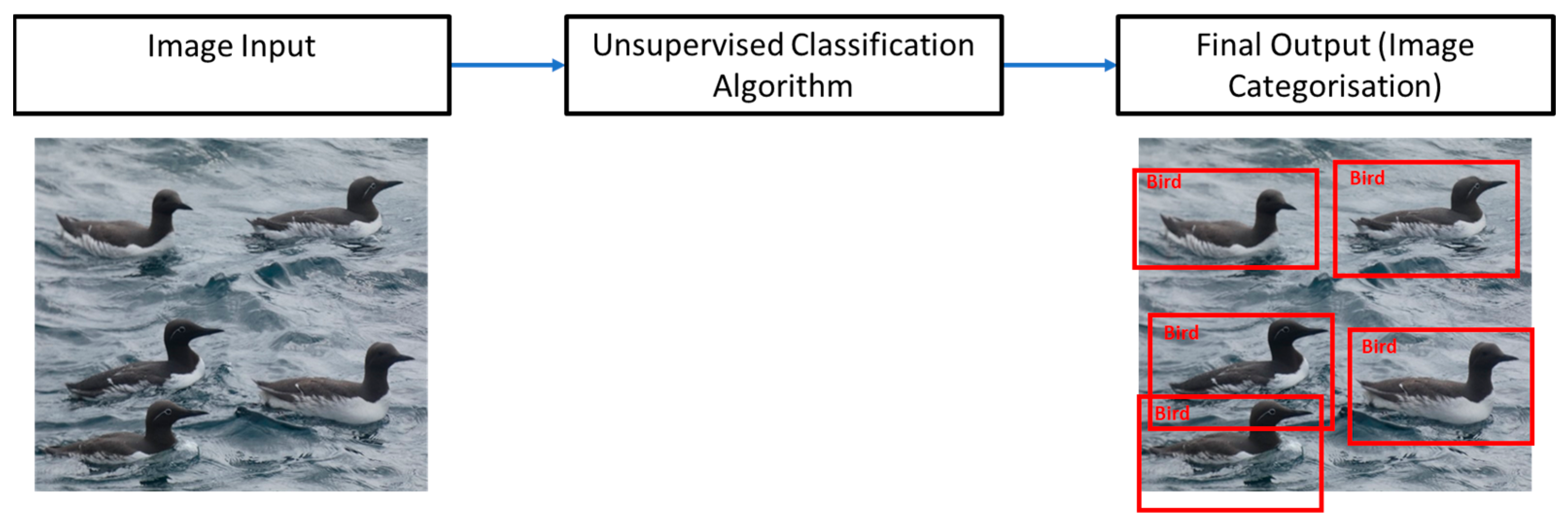
3.3. Supervised and Unsupervised Classification
3.4. Object-Based Image Analysis
3.5. Machine Learning and Deep Learning
4. Current Examples and Future Recommendations of Multirotor UAV Usage within Tidal Stream Environments
4.1. Current Examples
4.2. Future Recommendations
5. Conclusions
Supplementary Materials
Author Contributions
Funding
Data Availability Statement
Conflicts of Interest
References
- BEIS. Net Zero Strategy: Build Back Greener; HM Government: London, UK, 2021. [Google Scholar]
- Lewis, M.; Neill, S.P.; Robins, P.E.; Hashemi, M.R. Resource Assessment for Future Generations of Tidal-Stream Energy Arrays. Energy 2015, 83, 403–415. [Google Scholar] [CrossRef]
- Scherelis, C.; Penesis, I.; Hemer, M.A.; Cossu, R.; Wright, J.T.; Guihen, D. Investigating Biophysical Linkages at Tidal Energy Candidate Sites: A Case Study for Combining Environmental Assessment and Resource Characterisation. Renew. Energy 2020, 159, 399–413. [Google Scholar] [CrossRef]
- Zambrano, C. Lessons Learned from Subsea Tidal Kite Quarter Scale Ocean Trials. In Proceedings of the WTE16—Second Workshop on Wave and Tidal Energy, Valdivia, Chile, 16–18 November 2016. [Google Scholar]
- Magagna, D.; Uihlein, A. Ocean Energy Development in Europe: Current Status and Future Perspectives. Int. J. Mar. Energy 2015, 11, 84–104. [Google Scholar] [CrossRef]
- Jha, R.; Singh, V.P.; Singh, V.; Roy, L.B.; Thendiyath, R. River and Coastal Engineering; Springer: Berlin/Heidelberg, Germany, 2022; Volume 117. [Google Scholar]
- Burrows, R.; Yates, N.C.; Hedges, T.S.; Li, M.; Zhou, J.G.; Chen, D.Y.; Walkington, I.A.; Wolf, J.; Holt, J.; Proctor, R. Tidal Energy Potential in UK Waters. Proc. Inst. Civ. Eng. Marit. Eng. 2009, 162, 155–164. [Google Scholar] [CrossRef]
- Coles, D.; Angeloudis, A.; Greaves, D.; Hastie, G.; Lewis, M.; MacKie, L.; McNaughton, J.; Miles, J.; Neill, S.; Piggott, M.; et al. A Review of the UK and British Channel Islands Practical Tidal Stream Energy Resource. Proc. R. Soc. A Math. Phys. Eng. Sci. 2021, 477, 20210469. [Google Scholar] [CrossRef]
- Isaksson, N.; Masden, E.A.; Williamson, B.J.; Costagliola-Ray, M.M.; Slingsby, J.; Houghton, J.D.R.; Wilson, J. Assessing the Effects of Tidal Stream Marine Renewable Energy on Seabirds: A Conceptual Framework. Mar. Pollut. Bull. 2020, 157, 111314. [Google Scholar] [CrossRef] [PubMed]
- Rajgor, G. Tidal Developments Power Forward. Renew. Energy Focus 2016, 17, 147–149. [Google Scholar] [CrossRef]
- Fox, C.J.; Benjamins, S.; Masden, E.A.; Miller, R. Challenges and Opportunities in Monitoring the Impacts of Tidal-Stream Energy Devices on Marine Vertebrates. Renew. Sustain. Energy Rev. 2018, 81, 1926–1938. [Google Scholar] [CrossRef]
- Copping, A.; Battey, H.; Brown-Saracino, J.; Massaua, M.; Smith, C. An International Assessment of the Environmental Effects of Marine Energy Development. Ocean. Coast Manag. 2014, 99, 3–13. [Google Scholar] [CrossRef]
- Hunt, G.L.; Russell, R.W.; Coyle, K.O.; Weingartner, T. Comparative Foraging Ecology of Planktivorous Auklets in Relation to Ocean Physics and Prey Availability. Mar. Ecol. Prog. Ser. 1998, 167, 241–259. [Google Scholar] [CrossRef]
- European Parliament. Directive 2009/147/EC of the European Parliament and of the Council. Available online: https://eur-lex.europa.eu/legal-content/EN/TXT/?uri=CELEX:32009L0147 (accessed on 2 June 2022).
- Department for Environment Food & Rural Affairs. The Conservation of Habitats and Species (Amendment) (EU Exit) Regulations 2019. Available online: https://www.legislation.gov.uk/ukdsi/2019/9780111176573 (accessed on 14 November 2023).
- Frid, C.; Andonegi, E.; Depestele, J.; Judd, A.; Rihan, D.; Rogers, S.I.; Kenchington, E. The Environmental Interactions of Tidal and Wave Energy Generation Devices. Environ. Impact Assess. Rev. 2012, 32, 133–139. [Google Scholar] [CrossRef]
- Furness, R.W.; Wade, H.M.; Robbins, A.M.C.; Masden, E.A. Assessing the Sensitivity of Seabird Populations to Adverse Effects from Tidal Stream Turbines and Wave Energy Devices. ICES J. Mar. Sci. 2012, 69, 1466–1479. [Google Scholar] [CrossRef]
- Hutchison, I. Wave and Tidal Stream Critical Evidence Needs. Available online: https://tethys.pnnl.gov/publications/wave-tidal-stream-critical-evidence-needs (accessed on 29 January 2021).
- Lieber, L.; Nimmo-Smith, W.A.M.; Waggitt, J.J.; Kregting, L. Localised Anthropogenic Wake Generates a Predictable Foraging Hotspot for Top Predators. Commun. Biol. 2019, 2, 123. [Google Scholar] [CrossRef] [PubMed]
- Waggitt, J.J.; Cazenave, P.W.; Torres, R.; Williamson, B.J.; Scott, B.E. Predictable Hydrodynamic Conditions Explain Temporal Variations in the Density of Benthic Foraging Seabirds in a Tidal Stream Environment. ICES J. Mar. Sci. 2016, 73, 2677–2686. [Google Scholar] [CrossRef]
- Waggitt, J.J.; Cazenave, P.W.; Torres, R.; Williamson, B.J.; Scott, B.E. Quantifying Pursuit-Diving Seabirds’ Associations with Fine-Scale Physical Features in Tidal Stream Environments. J. Appl. Ecol. 2016, 53, 1653–1666. [Google Scholar] [CrossRef]
- Johnston, D.T.; Furness, R.W.; Robbins, A.M.C.; Tyler, G.; Taggart, M.A.; Masden, E.A. Black Guillemot Ecology in Relation to Tidal Stream Energy Generation: An Evaluation of Current Knowledge and Information Gaps. Mar. Environ. Res. 2018, 134, 121–129. [Google Scholar] [CrossRef] [PubMed]
- Lieber, L.; Langrock, R.; Nimmo-Smith, A. A Bird’s Eye View on Turbulence: Seabird Foraging Associations with Evolving Surface Flow Features. Proc. R. Soc. B 2021, 288, 20210592. [Google Scholar] [CrossRef] [PubMed]
- Couto, A.; Williamson, B.J.; Cornulier, T.; Fernandes, P.G.; Fraser, S.; Chapman, J.D.; Davies, I.M.; Scott, B.E. Tidal Streams, Fish, and Seabirds: Understanding the Linkages between Mobile Predators, Prey, and Hydrodynamics. Ecosphere 2022, 13, e4080. [Google Scholar] [CrossRef]
- Chabot, D.; Bird, D.M. Wildlife Research and Management Methods in the 21st Century: Where Do Unmanned Aircraft Fit In? J. Unmanned Veh. Syst. 2015, 3, 137–155. [Google Scholar] [CrossRef]
- Anderson, K.; Gaston, K.J. Lightweight Unmanned Aerial Vehicles Will Revolutionize Spatial Ecology. Front. Ecol. Environ. 2013, 11, 138–146. [Google Scholar] [CrossRef]
- Hendrickx, M.; Gheyle, W.; Bonne, J.; Bourgeois, J.; de Wulf, A.; Goossens, R. The Use of Stereoscopic Images Taken from a Microdrone for the Documentation of Heritage—An Example from the Tuekta Burial Mounds in the Russian Altay. J. Archaeol. Sci. 2011, 38, 2968–2978. [Google Scholar] [CrossRef]
- Christie, K.S.; Gilbert, S.L.; Brown, C.L.; Hatfield, M.; Hanson, L. Unmanned Aircraft Systems in Wildlife Research: Current and Future Applications of a Transformative Technology. Front. Ecol. Environ. 2016, 14, 241–251. [Google Scholar] [CrossRef]
- Barnas, A.F.; Chabot, D.; Hodgson, A.J.; Johnston, D.W.; Bird, D.M.; Ellis-Felege, S.N. A Standardized Protocol for Reporting Methods When Using Drones for Wildlife Research. J. Unmanned Veh. Syst. 2020, 8, 89–98. [Google Scholar] [CrossRef]
- Wolinsky, H. Biology Goes in the Air. EMBO Rep. 2017, 18, 1284–1289. [Google Scholar] [CrossRef] [PubMed]
- Rush, G.P.; Clarke, L.E.; Stone, M.; Wood, M.J. Can Drones Count Gulls? Minimal Disturbance and Semiautomated Image Processing with an Unmanned Aerial Vehicle for Colony-Nesting Seabirds. Ecol. Evol. 2018, 8, 12322–12334. [Google Scholar] [CrossRef] [PubMed]
- Waite, C.E.; van der Heijden, G.M.F.; Field, R.; Boyd, D.S. A View from above: Unmanned Aerial Vehicles (UAVs) Provide a New Tool for Assessing Liana Infestation in Tropical Forest Canopies. J. Appl. Ecol. 2019, 56, 902–912. [Google Scholar] [CrossRef]
- Colefax, A.P.; Butcher, P.A.; Kelaher, B.P. The Potential for Unmanned Aerial Vehicles (UAVs) to Conduct Marine Fauna Surveys in Place of Manned Aircraft. ICES J. Mar. Sci. 2018, 75, 1–8. [Google Scholar] [CrossRef]
- Hodgson, J.C.; Baylis, S.M.; Mott, R.; Herrod, A.; Clarke, R.H. Precision Wildlife Monitoring Using Unmanned Aerial Vehicles. Sci. Rep. 2016, 6, 22574. [Google Scholar] [CrossRef]
- Yaney-Keller, A.; San Martin, R.; Reina, R.D. Comparison of UAV and Boat Surveys for Detecting Changes in Breeding Population Dynamics of Sea Turtles. Remote Sens. 2021, 13, 2857. [Google Scholar] [CrossRef]
- Edney, A.J.; Wood, M.J. Applications of Digital Imaging and Analysis in Seabird Monitoring and Research. Ibis 2020, 163, 317–337. [Google Scholar] [CrossRef]
- Kiszka, J.J.; Mourier, J.; Gastrich, K.; Heithaus, M.R. Using Unmanned Aerial Vehicles (UAVs) to Investigate Shark and Ray Densities in a Shallow Coral Lagoon. Mar. Ecol. Prog. Ser. 2016, 560, 237–242. [Google Scholar] [CrossRef]
- Sweeney, K.L.; Helker, V.T.; Perryman, W.L.; LeRoi, D.J.; Fritz, L.W.; Gelatt, T.S.; Angliss, R.P. Flying beneath the Clouds at the Edge of the World: Using a Hexacopter to Supplement Abundance Surveys of Steller Sea Lions (Eumetopias Jubatus) in Alaska. J. Unmanned Veh. Syst. 2016, 4, 70–81. [Google Scholar] [CrossRef]
- Casella, E.; Collin, A.; Harris, D.; Ferse, S.; Bejarano, S.; Parravicini, V.; Hench, J.L.; Rovere, A. Mapping Coral Reefs Using Consumer-Grade Drones and Structure from Motion Photogrammetry Techniques. Coral Reefs 2017, 36, 269–275. [Google Scholar] [CrossRef]
- Li, T.; Zhang, B.; Cheng, X.; Hui, F.; Li, Y. Leveraging the UAV to Support Chinese Antarctic Expeditions: A New Perspective. Adv. Polar. Sci. 2021, 32, 67–74. [Google Scholar] [CrossRef]
- Smith, C.E.; Sykora-Bodie, S.T.; Bloodworth, B.; Pack, S.M.; Spradlin, T.R.; LeBoeuf, N.R. Assessment of Known Impacts of Unmanned Aerial Systems (UAS) on Marine Mammals: Data Gaps and Recommendations for Researchers in the United States. J. Unmanned Veh. Syst. 2016, 4, 31–44. [Google Scholar] [CrossRef]
- Goebel, M.E.; Perryman, W.L.; Hinke, J.T.; Krause, D.J.; Hann, N.A.; Gardner, S.; LeRoi, D.J. A Small Unmanned Aerial System for Estimating Abundance and Size of Antarctic Predators. Polar. Biol. 2015, 38, 619–630. [Google Scholar] [CrossRef]
- Yang, Z.; Yu, X.; Dedman, S.; Rosso, M.; Zhu, J.; Yang, J.; Xia, Y.; Tian, Y.; Zhang, G.; Wang, J. UAV Remote Sensing Applications in Marine Monitoring: Knowledge Visualization and Review. Sci. Total Environ. 2022, 838, 155939. [Google Scholar] [CrossRef]
- Durban, J.W.; Michael, S.A.; Moore, J.; Gloria, S.A.; Bahamonde, P.-L.A.; Perryman, W.L.; Donald, S.A.; Leroi, J. Photogrammetry of Blue Whales with an Unmanned Hexacopter. Notes Mar. Mammal Sci. 2016, 32, 1510–1515. [Google Scholar] [CrossRef]
- Durban, J.; Fearnbach, H.; Barrett-Lennard, L.; Perryman, W.; Leroi, D. Photogrammetry of Killer Whales Using a Small Hexacopter Launched at Sea. J. Unmanned Veh. Syst. 2015, 3, 131–135. [Google Scholar] [CrossRef]
- Sardà-Palomera, F.; Bota, G.; Viñolo, C.; Pallarés, O.; Sazatornil, V.; Brotons, L.; Gomáriz, S.; Sardà, F. Fine-Scale Bird Monitoring from Light Unmanned Aircraft Systems. Ibis 2012, 154, 177–183. [Google Scholar] [CrossRef]
- Rieucau, G.; Kiszka, J.J.; Castillo, J.C.; Mourier, J.; Boswell, K.M.; Heithaus, M.R. Using Unmanned Aerial Vehicle (UAV) Surveys and Image Analysis in the Study of Large Surface-Associated Marine Species: A Case Study on Reef Sharks Carcharhinus Melanopterus Shoaling Behaviour. J. Fish Biol. 2018, 93, 119–127. [Google Scholar] [CrossRef] [PubMed]
- Borowicz, A.; McDowall, P.; Youngflesh, C.; Sayre-Mccord, T.; Clucas, G.; Herman, R.; Forrest, S.; Rider, M.; Schwaller, M.; Hart, T.; et al. Multi-Modal Survey of Adélie Penguin Mega-Colonies Reveals the Danger Islands as a Seabird Hotspot. Sci. Rep. 2018, 8, 3926. [Google Scholar] [CrossRef] [PubMed]
- Gooday, O.J.; Key, N.; Goldstien, S.; Zawar-Reza, P. An Assessment of Thermal-Image Acquisition with an Unmanned Aerial Vehicle (UAV) for Direct Counts of Coastal Marine Mammals Ashore. J. Unmanned Veh. Syst. 2018, 6, 100–108. [Google Scholar] [CrossRef]
- Žydelis, R.; Dorsch, M.; Heinänen, S.; Nehls, G.; Weiss, F. Comparison of Digital Video Surveys with Visual Aerial Surveys for Bird Monitoring at Sea. J. Ornithol. 2019, 160, 567–580. [Google Scholar] [CrossRef]
- Hodgson, J.C.; Koh, L.P. Best Practice for Minimising Unmanned Aerial Vehicle Disturbance to Wildlife in Biological Field Research. Curr. Biol. 2016, 26, R404–R405. [Google Scholar] [CrossRef] [PubMed]
- Acevedo-Whitehouse, K.; Rocha-Gosselin, A.; Gendron, D. A Novel Non-Invasive Tool for Disease Surveillance of Free-Ranging Whales and Its Relevance to Conservation Programs. Anim. Conserv. 2010, 13, 217–225. [Google Scholar] [CrossRef]
- Geoghegan, J.L.; Pirotta, V.; Harvey, E.; Smith, A.; Buchmann, J.P.; Ostrowski, M.; Eden, J.S.; Harcourt, R.; Holmes, E.C. Virological Sampling of Inaccessible Wildlife with Drones. Viruses 2018, 10, 300. [Google Scholar] [CrossRef]
- Christiansen, F.; Rojano-Doñate, L.; Madsen, P.T.; Bejder, L. Noise Levels of Multi-Rotor Unmanned Aerial Vehicles with Implications for Potential Underwater Impacts on Marine Mammals. Front. Mar. Sci. 2016, 3, 277. [Google Scholar] [CrossRef]
- Pomeroy, P.; O’Connor, L.; Davies, P. Assessing Use of and Reaction to Unmanned Aerial Systems in Gray and Harbor Seals during Breeding and Molt in the UK. J. Unmanned Veh. Syst. 2015, 3, 102–113. [Google Scholar] [CrossRef]
- Zink, R.; Kmetova-Biro, E.; Agnezy, S.; Klisurov, I.; Margalida, A. Assessing the Potential Disturbance Effects on the Use of Unmanned Aircraft Systems (UASs) for European Vultures Research: A Review and Conservation Recommendations. Bird Conserv. Int. 2023, 33, e45. [Google Scholar] [CrossRef]
- Verfuss, U.K.; Aniceto, A.S.; Harris, D.V.; Gillespie, D.; Fielding, S.; Jiménez, G.; Johnston, P.; Sinclair, R.R.; Sivertsen, A.; Solbø, S.A.; et al. A Review of Unmanned Vehicles for the Detection and Monitoring of Marine Fauna. Mar. Pollut. Bull. 2019, 140, 17–29. [Google Scholar] [CrossRef] [PubMed]
- Fiori, L.; Doshi, A.; Martinez, E.; Orams, M.B.; Bollard-Breen, B. The Use of Unmanned Aerial Systems in Marine Mammal Research. Remote Sens. 2017, 9, 543. [Google Scholar] [CrossRef]
- Rees, A.; Avens, L.; Ballorain, K.; Bevan, E.; Broderick, A.C.; Carthy, R.R.; Christianen, M.J.A.; Duclos, G.; Heithaus, M.R.; Johnston, D.W.; et al. The Potential of Unmanned Aerial Systems for Sea Turtle Research and Conservation: A Review and Future Directions. Endanger. Species Res. 2018, 35, 81–100. [Google Scholar] [CrossRef]
- Zu, C.X.; Li, H. Thermodynamic Analysis on Energy Densities of Batteries. Energy Environ. Sci. 2011, 4, 2614–2624. [Google Scholar] [CrossRef]
- Galkin, B.; Kibilda, J.; DaSilva, L.A. UAVs as Mobile Infrastructure: Addressing Battery Lifetime. IEEE Commun. Mag. 2019, 57, 132–137. [Google Scholar] [CrossRef]
- Lee, D.; Zhou, J.; Lin, W.T. Autonomous Battery Swapping System for Quadcopter. In Proceedings of the 2015 International Conference on Unmanned Aircraft Systems, ICUAS, Denver, CO, USA, 9–12 June 2015; pp. 118–124. [Google Scholar]
- Mangewa, L.J.; Ndakidemi, P.A.; Munishi, L.K. Integrating UAV Technology in an Ecological Monitoring System for Community Wildlife Management Areas in Tanzania. Sustainability 2019, 11, 6116. [Google Scholar] [CrossRef]
- Hardin, P.; Jensen, R. Small-Scale Unmanned Aerial Vehicles in Environmental Remote Sensing: Challenges and Opportunities. GIScience Remote Sens. 2011, 48, 99–111. [Google Scholar] [CrossRef]
- Hodgson, A.; Kelly, N.; Peel, D. Unmanned Aerial Vehicles (UAVs) for Surveying Marine Fauna: A Dugong Case Study. PLoS ONE 2013, 8, e79556. [Google Scholar] [CrossRef]
- Ortega-Terol, D.; Hernandez-Lopez, D.; Ballesteros, R.; Gonzalez-Aguilera, D. Automatic Hotspot and Sun Glint Detection in UAV Multispectral Images. Sensors 2017, 17, 2352. [Google Scholar] [CrossRef]
- Drever, M.C.; Chabot, D.; O’hara, P.D.; Thomas, J.D.; Breault, A.; Millikin, R.L. Evaluation of an Unmanned Rotorcraft to Monitor Wintering Waterbirds and Coastal Habitats in British Columbia, Canada. J. Unmanned Veh. Syst. 2015, 3, 259–267. [Google Scholar] [CrossRef]
- Chabot, D.; Francis, C.M. Computer-Automated Bird Detection and Counts in High-Resolution Aerial Images: A Review. J. Field Ornithol. 2016, 87, 343–359. [Google Scholar] [CrossRef]
- Glasbey, C.A.; Horgan, G.W.; Darbyshire, J.F. Image Analysis and Three-dimensional Modelling of Pores in Soil Aggregates. J. Soil Sci. 1991, 42, 479–486. [Google Scholar] [CrossRef]
- Laliberte, S.; Ripple, W.J. Automated Wildlife Counts from Remotely Sensed Imagery. Wildl. Soc. Bull. 2003, 31, 362–371. [Google Scholar]
- Trathan, P.N. Image Analysis of Color Aerial Photography to Estimate Penguin Population Size. Wildl. Soc. Bull. 2004, 32, 332–343. [Google Scholar] [CrossRef]
- Hollings, T.; Burgman, M.; van Andel, M.; Gilbert, M.; Robinson, T.; Robinson, A. How Do You Find the Green Sheep? A Critical Review of the Use of Remotely Sensed Imagery to Detect and Count Animals. Methods Ecol. Evol. 2018, 9, 881–892. [Google Scholar] [CrossRef]
- Minaee, S.; Boykov, Y.; Porikli, F.; Plaza, A.; Kehtarnavaz, N.; Terzopoulos, D. Image Segmentation Using Deep Learning: A Survey. IEEE Trans. Pattern Anal. Mach. Intell. 2020, 44, 3523–3542. [Google Scholar] [CrossRef] [PubMed]
- Wellner, P.D. Adaptive Thresholding for the DigitalDesk; Rank Xerox Ltd.: Cambridge, UK, 1993. [Google Scholar]
- Bradley, D.; Roth, G. Adaptive Thresholding Using the Integral Image. J. Graph. Tools 2007, 12, 13–21. [Google Scholar] [CrossRef]
- LaRue, M.A.; Stapleton, S.; Porter, C.; Atkinson, S.; Atwood, T.; Dyck, M.; Lecomte, N. Testing Methods for Using High-Resolution Satellite Imagery to Monitor Polar Bear Abundance and Distribution. Wildl. Soc. Bull. 2015, 39, 772–779. [Google Scholar] [CrossRef]
- Fretwell, P.T.; LaRue, M.A.; Morin, P.; Kooyman, G.L.; Wienecke, B.; Ratcliffe, N.; Fox, A.J.; Fleming, A.H.; Porter, C.; Trathan, P.N. An Emperor Penguin Population Estimate: The First Global, Synoptic Survey of a Species from Space. PLoS ONE 2012, 7, e33751. [Google Scholar] [CrossRef]
- Fretwell, P.T.; Staniland, I.J.; Forcada, J. Whales from Space: Counting Southern Right Whales by Satellite. PLoS ONE 2014, 9, 88655. [Google Scholar] [CrossRef]
- Terletzky, P.A.; Ramsey, R.D. Comparison of Three Techniques to Identify and Count Individual Animals in Aerial Imagery. J. Signal Inf. Process. 2016, 07, 123–135. [Google Scholar] [CrossRef]
- Chrétien, L.P.; Théau, J.; Ménard, P. Visible and Thermal Infrared Remote Sensing for the Detection of White-Tailed Deer Using an Unmanned Aerial System. Wildl. Soc. Bull. 2016, 40, 181–191. [Google Scholar] [CrossRef]
- Blaschke, T. Object Based Image Analysis for Remote Sensing. ISPRS J. Photogramm. Remote Sens. 2010, 65, 2–16. [Google Scholar] [CrossRef]
- Guirado, E.; Tabik, S.; Alcaraz-Segura, D.; Cabello, J.; Herrera, F. Deep-Learning Versus OBIA for Scattered Shrub Detection with Google Earth Imagery: Ziziphus Lotus as Case Study. Remote Sens. 2017, 9, 1220. [Google Scholar] [CrossRef]
- Groom, G.; Petersen, I.K.; Anderson, M.D.; Fox, A.D. Using Object-Based Analysis of Image Data to Count Birds: Mapping of Lesser Flamingos at Kamfers Dam, Northern Cape, South Africa. Int. J. Remote Sens. 2011, 32, 4611–4639. [Google Scholar] [CrossRef]
- Zhong, S.; Zhang, K.; Bagheri, M.; Burken, J.G.; Gu, A.; Li, B.; Ma, X.; Marrone, B.L.; Ren, Z.J.; Schrier, J.; et al. Machine Learning: New Ideas and Tools in Environmental Science and Engineering. Environ. Sci. Technol. 2021, 55, 12741–12754. [Google Scholar] [CrossRef]
- Zhao, R.; Li, C.; Ye, S.; Fang, X. Butterfly Recognition Based on Faster R-CNN. Proc. J. Phys. Conf. Ser. 2019, 1176, 032048. [Google Scholar] [CrossRef]
- Lürig, M.D.; Donoughe, S.; Svensson, E.I.; Porto, A.; Tsuboi, M. Computer Vision, Machine Learning, and the Promise of Phenomics in Ecology and Evolutionary Biology. Front. Ecol. Evol. 2021, 9, 148. [Google Scholar] [CrossRef]
- Goodfellow, I.; Bengio, Y.; Courville, A. Deep Learning; MIT Press: Cambridge, MA, USA, 2016. [Google Scholar]
- Ren, S.; He, K.; Girshick, R.; Sun, J. Faster R-CNN: Towards Real-Time Object Detection with Region Proposal Networks. IEEE Trans. Pattern Anal. Mach. Intell. 2017, 39, 1137–1149. [Google Scholar] [CrossRef]
- Ben Boudaoud, L.; Maussang, F.; Garello, R.; Chevallier, A. Marine Bird Detection Based on Deep Learning Using High-Resolution Aerial Images. In Proceedings of the OCEANS 2019-Marseille, Marseille, France, 17–20 June 2019; pp. 1–7. [Google Scholar]
- Maganathan, T.; Senthilkumar, S.; Balakrishnan, V. Machine Learning and Data Analytics for Environmental Science: A Review, Prospects and Challenges. In Proceedings of the IOP Conference Series: Materials Science and Engineering; IOP Publishing: Bristol, UK, 2020; Volume 955, p. 012107. [Google Scholar]
- McIlvenny, J.; Williamson, B.J.; Fairley, I.A.; Lewis, M.; Neill, S.; Masters, I.; Reeve, D.E. Comparison of Dense Optical Flow and PIV Techniques for Mapping Surface Current Flow in Tidal Stream Energy Sites. Int. J. Energy Environ. Eng. 2022, 14, 273–285. [Google Scholar] [CrossRef]
- Thielicke, W.; Sonntag, R. Particle Image Velocimetry for MATLAB: Accuracy and Enhanced Algorithms in PIVlab. J. Open Res. Softw. 2021, 9, 12. [Google Scholar] [CrossRef]
- Fairley, I.; Williamson, B.J.; McIlvenny, J.; King, N.; Masters, I.; Lewis, M.; Neill, S.; Glasby, D.; Coles, D.; Powell, B.; et al. Drone-Based Large-Scale Particle Image Velocimetry Applied to Tidal Stream Energy Resource Assessment. Renew. Energy 2022, 196, 839–855. [Google Scholar] [CrossRef]
- Slingsby, J.; Scott, B.E.; Kregting, L.; Mcilvenny, J.; Wilson, J.; Couto, A.; Roos, D.; Yanez, M.; Williamson, B.J. Surface Characterisation of Kolk-Boils within Tidal Stream Environments Using UAV Imagery. J. Mar. Sci. Eng. 2021, 9, 484. [Google Scholar] [CrossRef]
- Slingsby, J.; Scott, B.E.; Kregting, L.; McIlvenny, J.; Wilson, J.; Yanez, M.; Langlois, S.; Williamson, B.J. Using Unmanned Aerial Vehicle (UAV) Imagery to Characterise Pursuit-Diving Seabird Association With Tidal Stream Hydrodynamic Habitat Features. Front. Mar. Sci. 2022, 9, 820722. [Google Scholar] [CrossRef]
- Faye, E.; Rebaudo, F.; Yánez-Cajo, D.; Cauvy-Fraunié, S.; Dangles, O. A Toolbox for Studying Thermal Heterogeneity across Spatial Scales: From Unmanned Aerial Vehicle Imagery to Landscape Metrics. Methods Ecol. Evol. 2016, 7, 437–446. [Google Scholar] [CrossRef]
- Williamson, B.J.; Blondel, P.; Williamson, L.D.; Scott, B.E. Application of a Multibeam Echosounder to Document Changes in Animal Movement and Behaviour around a Tidal Turbine Structure. ICES J. Mar. Sci. 2021, 78, 1253–1266. [Google Scholar] [CrossRef]
- Benjamins, S.; Dale, A.; Van Geel, N.; Wilson, B. Riding the Tide: Use of a Moving Tidal-Stream Habitat by Harbour Porpoises. Mar. Ecol. Prog. Ser. 2016, 549, 275–288. [Google Scholar] [CrossRef]
- Albahli, S.; Nawaz, M.; Javed, A.; Irtaza, A. An Improved Faster-RCNN Model for Handwritten Character Recognition. Arab. J. Sci. Eng. 2021, 46, 8509–8523. [Google Scholar] [CrossRef]


| Title | Citation Number | Origin | Purpose | Image Processing Technique | Summary |
|---|---|---|---|---|---|
| Computer-automated bird detection and counts in high-resolution aerial images | [68] | droneMetrics, Ontario, Canada | To review the literature on automated approaches for counting birds in aerial images | Thresholding, spectral thresholding and object-based image analysis (OBIA) | There have been major advances over the past three decades, from performing rudimentary spectral analysis of scanned film photographs to developing elaborate algorithms capable of detecting multiple species in thousands of digital images with complex backgrounds. |
| Image analysis and three-dimensional modelling of pores in soil aggregates | [69] | University of Edinburgh, Edinburgh, UK | Image analysis and three-dimensional modelling of pores in soil aggregates | Mathematical morphology thresholding | The three-dimensional simulation of soil aggregates using image analysis based on some characteristics measured in two-dimensional sections of soil aggregates appears to be possible. |
| Automated wildlife counts from remotely sensed imagery | [70] | Oregon State University, Corvallis, USA | To develop an image processing technique for detection and automated counts of wildlife from aerial photos | Thresholding | The techniques are simple to use and require only basic image analysis knowledge. In addition, all the analyses could be performed using a public domain programme accessible for download from the Internet. |
| Image analysis of colour aerial photography to estimate penguin population size | [71] | British Antarctic Survey, Cambridge, UK | To develop a method of estimating penguin population size (with confidence intervals) from colour aerial photography using image analysis techniques | Segmentation thresholding | The image analysis techniques described provide a reliable method, but the use of segmentation and threshold filters may be inefficient. |
| How do you find the green sheep? A critical review of the use of remotely sensed imagery to detect and count animals | [72] | University of Melbourne, Melbourne, Australia | To examine methods for analysing remotely sensed imagery to estimate the abundance of wild and domestic animals by directly detecting, identifying and counting individuals | Thresholding, image segmentation, supervised classification, OBIA, linear discriminant analysis, birth-and-death algorithm, morphological-based detection, artificial neural network, image differencing using principal components analysis and supervised spectral classification | The direct detection and counting of individual animals to establish an accurate population measure using automated and semiautomated techniques is still problematic in most situations, particularly in nonhomogeneous environments, and is currently ineffective for most large-scale applications. |
| Adaptive thresholding for the DigitalDesk | [74] | Rank Xerox Research Centre, Cambridge, UK | To describe the various techniques that were developed and tested for thresholding on the DigitalDesk and end with a description of an algorithm that was found to be suitable | Global thresholding, adaptive thresholding, adaptive thresholding based on Wall’s algorithm and quick adaptive thresholding | Several techniques are explored, leading eventually to a quick adaptive thresholding algorithm that has proven to be quite suitable for current purposes. |
| Adaptive thresholding using the integral image | [75] | Carleton University, Canada | To present a very simple and clear adaptive thresholding technique using integral images | Adaptive thresholding | The technique is well-suited for scenes with strong spatial changes in illumination. The main drawback to the method is that images must be processed twice. |
| Testing methods for using high-resolution satellite imagery to monitor polar bear abundance and distribution | [76] | University of Minnesota, Minneapolis, USA | To evaluate opportunities for expanding large-scale applications of satellite imagery | Percent reflectance and image thresholding | Very high-resolution satellite imagery is among the new tools available to estimate the abundance of large mammals, but more research is needed to understand how this tool can best be applied to studying and managing wildlife. |
| Title | Citation Number | Origin | Purpose | Image Processing Technique | Summary |
|---|---|---|---|---|---|
| How do you find the green sheep? A critical review of the use of remotely sensed imagery to detect and count animals | [72] | University of Melbourne, Melbourne, Australia | To examine methods for analysing remotely sensed imagery to estimate the abundance of wild and domestic animals by directly detecting, identifying and counting individuals | Thresholding, image segmentation, supervised classification, OBIA, linear discriminant analysis, birth-and-death algorithm, morphological-based detection, artificial neural network, image differencing using principal components analysis and supervised spectral classification | The direct detection and counting of individual animals to establish an accurate population measure using automated and semiautomated techniques is still problematic in most situations, particularly in nonhomogeneous environments, and is currently ineffective for most large-scale applications. |
| An emperor penguin population estimate: the first global, synoptic survey of a species from space | [77] | British Antarctic Survey, Cambridge, UK | To present the first synoptic survey of the entire population of a single species (breeding in a single year) using satellite remote sensing | Supervised classification | The results of this survey increase our knowledge of species’ population and distribution, and the techniques developed in this study may be applicable to several other animals. |
| Whales from space: counting southern right whales by satellite | [78] | British Antarctic Survey, Cambridge, UK | To describe a method of identifying and counting southern right whales breeding in part of the Golfo Nuevo in Argentina using satellite imagery | Maximum likelihood supervised classification | Methods can potentially help provide within and between-season population estimates both for right whales and other species of whale that breed in sheltered locations. |
| Comparison of three techniques to identify and count individual animals in aerial imagery | [79] | Utah State University, Logan, USA | To examine three methods to enumerate animals in remotely sensed aerial imagery | Manual processing, unsupervised classification: iterative self-organising analysis technique (ISODATA), segmentation, multi-image and multistep (MIMS) technique | If animals were present in an image, the ISODATA technique correctly identified most of the animals but greatly overestimated numbers. |
| Visible and thermal infrared remote sensing for the detection of white-tailed deer using an unmanned aerial system | [80] | Universite de Sherbrooke, Sherbrooke, Canada | To evaluate the performance of an aircraft sensor system developed for detecting and counting white-tailed deer in a controlled environment | Supervised pixel-based image classification, unsupervised pixel-based image classification and OBIA | The OBIA approach has the potential to reduce and standardise visibility bias using imaging sensors and, contrary to the pixel-based approach, can indicate the absence of deer. |
| Title | Citation Number | Origin | Purpose | Image Processing Technique | Summary |
|---|---|---|---|---|---|
| Computer-automated bird detection and counts in high-resolution aerial images | [68] | droneMetrics, Ontario, Canada | To review the literature on automated approaches for counting birds in aerial images | Thresholding, spectral thresholding and object-based image analysis (OBIA) | There have been major advances over the past three decades, from performing rudimentary spectral analysis of scanned film photographs to developing elaborate algorithms capable of detecting multiple species in thousands of digital images with complex backgrounds. |
| How do you find the green sheep? A critical review of the use of remotely sensed imagery to detect and count animals | [72] | University of Melbourne, Melbourne, Australia | To examine methods for analysing remotely sensed imagery to estimate the abundance of wild and domestic animals by directly detecting, identifying and counting individuals | Thresholding, image segmentation, supervised classification, OBIA, linear discriminant analysis, birth-and-death algorithm, morphological-based detection, artificial neural network, image differencing using principal components analysis and supervised spectral classification | The direct detection and counting of individual animals to establish an accurate population measure using automated and semiautomated techniques is still problematic in most situations, particularly in nonhomogeneous environments, and is currently ineffective for most large-scale applications. |
| Object-based image analysis for remote sensing | [81] | University of Salzberg, Salzberg, Austria | To assess recent developments in object-based image analysis | Object-based image analysis | OBIA methods are making considerable progress towards a spatially explicit information extraction workflow, such as is required for spatial planning as well as for many monitoring programmes. |
| Visible and thermal infrared remote sensing for the detection of white-tailed deer using an unmanned aerial system | [80] | Universite de Sherbrooke, Sherbrooke, Canada | To evaluate the performance of an aircraft sensor system developed for detecting and counting white-tailed deer in a controlled environment | Supervised pixel-based image classification, unsupervised pixel-based image classification and OBIA | The OBIA approach has the potential to reduce and standardise visibility bias using imaging sensors and, contrary to the pixel-based approach, can indicate the absence of deer. |
| Using object-based analysis of image data to count birds: mapping of lesser flamingos at Kamfers Dam, Northern Cape, South Africa | [83] | Aarhus University, Rønde, Denmark | To report the application of OBIA for a count of lesser flamingos (Phoeniconaias minor) at the Kamfers Dam Lake, Kimberley, South Africa | Object-based image analysis | The work has demonstrated the possibilities for using automated object-based image analysis methods for counting and mapping bird individuals and exploiting image data patterns in ways that would not be possible with a per-pixel approach. |
| Title | Citation Number | Origin | Purpose | Image Processing Technique | Summary |
|---|---|---|---|---|---|
| Applications of digital imaging and analysis in seabird monitoring and research | [36] | University of Gloucestershire, Cheltenham, UK | To assess the accuracy and cost of manual, semiautomated and automated image analysis methods, as well as consider future developments needed in the field | Manual image analysis, semiautomated classification and convolutional neural networks | Automated image analysis can be cost-effective once machine learning algorithms are up and running. For small-scale studies on a single species, manual or semiautomated analysis may be more achievable. |
| How do you find the green sheep? A critical review of the use of remotely sensed imagery to detect and count animals | [72] | University of Melbourne, Melbourne, Australia | To examine methods for analysing remotely sensed imagery to estimate the abundance of wild and domestic animals by directly detecting, identifying and counting individuals | Thresholding, image segmentation, supervised classification, OBIA, linear discriminant analysis, birth-and-death algorithm, morphological-based detection, artificial neural network, image differencing using principal components analysis and supervised spectral classification | The direct detection and counting of individual animals to establish an accurate population measure using automated and semiautomated techniques is still problematic in most situations, particularly in nonhomogeneous environments, and is currently ineffective for most large-scale applications. |
| Machine learning: new ideas and tools in environmental science and engineering | [84] | Case Western Reserve University, Cleveland, USA | To discuss the status, essential knowledge, shortcomings, challenges and future opportunities of machine learning (ML) in environmental science and engineering (ESE) to highlight the potential of ML in the ESE field | Supervised machine learning and unsupervised machine learning | ML shows great potential for solving ESE issues, with wide-ranging applicability, but inexperience with ML may lead to unsatisfactory performance or inappropriate applications of ML tools. |
| Butterfly recognition based on faster R-CNN | [85] | Zhengzhou University, Zhengzhou, China | To use deep learning technology to apply faster R-CNN to butterfly recognition | Deep learning: faster R-CNN | Faster R-CNN can achieve stable classification and high levels of recognition accuracy. However, adequate training data sample sizes and randomness of samples when testing must be maintained to ensure this. |
| Computer vision (CV), machine learning, and the promise of phenomics in ecology and evolutionary biology | [86] | Lund University, Lund, Sweden | To provide an entry point for ecologists and evolutionary biologists to the automatic and semiautomatic extraction of phenotypic data from digital images | Machine learning and deep learning | This review provided a broad overview of various computer vision techniques and gave some recent examples of their application in ecological and evolutionary research. |
| Deep learning | [87] | Massachusetts Institute of Technology, Cambridge, USA | To describe machine learning concepts, established deep learning algorithms and future research | Machine learning and deep learning | Deep learning can be used to solve applications in computer vision, speech recognition, natural language processing and other areas of commercial interest. |
| Faster R-CNN: towards real-time object detection with region proposal networks | [88] | University of Science and Technology of China, Hefei, China | To introduce a region proposal network (RPN) that shares full-image convolutional features with a detection network, thus enabling nearly cost-free region proposals | Deep learning: faster R-CNN | The method enables a unified, deep-learning-based object detection system to run at near real-time frame rates. The learned RPN also improves region proposal quality and, thus, overall object detection accuracy. |
| Marine bird detection based on deep learning using high-resolution aerial images | [89] | IMT Atlantique, Nantes, France | To consider recent developments in deep learning. More specifically, the use of convolutional neural networks (CNNs) for the task of detection and classification | Deep learning: convolutional neural networks | CNNs are a suitable tool for detecting marine birds in aerial images. However, there is room for performance improvement regarding classification accuracy and processing time. |
| Machine learning and data analytics for environmental science: a review, prospects and challenges | [90] | Bannari Amman Institute of Technology, Sathyamangalam, India | To describe the basic concepts of machine learning, deep learning and data analytics and find state-of-the-art applications in environmental science | Machine learning and deep learning | Existing machine learning and deep learning algorithms have been implemented to overcome diverse environmental issues, but further discussion is required to frame the policies to address and resolve environmental challenges. |
Disclaimer/Publisher’s Note: The statements, opinions and data contained in all publications are solely those of the individual author(s) and contributor(s) and not of MDPI and/or the editor(s). MDPI and/or the editor(s) disclaim responsibility for any injury to people or property resulting from any ideas, methods, instructions or products referred to in the content. |
© 2023 by the authors. Licensee MDPI, Basel, Switzerland. This article is an open access article distributed under the terms and conditions of the Creative Commons Attribution (CC BY) license (https://creativecommons.org/licenses/by/4.0/).
Share and Cite
Slingsby, J.; Scott, B.E.; Kregting, L.; McIlvenny, J.; Wilson, J.; Williamson, B.J. A Review of Unmanned Aerial Vehicles Usage as an Environmental Survey Tool within Tidal Stream Environments. J. Mar. Sci. Eng. 2023, 11, 2298. https://doi.org/10.3390/jmse11122298
Slingsby J, Scott BE, Kregting L, McIlvenny J, Wilson J, Williamson BJ. A Review of Unmanned Aerial Vehicles Usage as an Environmental Survey Tool within Tidal Stream Environments. Journal of Marine Science and Engineering. 2023; 11(12):2298. https://doi.org/10.3390/jmse11122298
Chicago/Turabian StyleSlingsby, James, Beth E. Scott, Louise Kregting, Jason McIlvenny, Jared Wilson, and Benjamin J. Williamson. 2023. "A Review of Unmanned Aerial Vehicles Usage as an Environmental Survey Tool within Tidal Stream Environments" Journal of Marine Science and Engineering 11, no. 12: 2298. https://doi.org/10.3390/jmse11122298
APA StyleSlingsby, J., Scott, B. E., Kregting, L., McIlvenny, J., Wilson, J., & Williamson, B. J. (2023). A Review of Unmanned Aerial Vehicles Usage as an Environmental Survey Tool within Tidal Stream Environments. Journal of Marine Science and Engineering, 11(12), 2298. https://doi.org/10.3390/jmse11122298