Article

First Documentation of Large Submarine Sinkholes on the Ganquan Carbonate Platform in the Xisha Islands, South China Sea

1
Key Laboratory of Marine Mineral Resources, Ministry of Natural Resources, Guangzhou Marine Geological Survey, China Geological Survey, Guangzhou 511458, China
2
National Engineering Research Center for Gas Hydrate Exploration and Development, Guangzhou 511458, China
3
Institute of Deep-Sea Science and Engineering, Chinese Academy of Sciences, Sanya 572000, China
*
Authors to whom correspondence should be addressed.
J. Mar. Sci. Eng. 2023, 11(11), 2171; https://doi.org/10.3390/jmse11112171
Submission received: 8 October 2023 / Revised: 4 November 2023 / Accepted: 13 November 2023 / Published: 15 November 2023
(This article belongs to the Section Geological Oceanography)

Abstract

:
Submarine sinkholes are unique and important geomorphological features with a typical cavity structure that are of great scientific value. Submarine sinkholes were discovered for the first time in the isolated Ganquan carbonate platform on the Xisha Islands, the northwestern South China Sea. Based on high-resolution multibeam bathymetric data and seismic profile data, we identified 37 submarine sinkholes at water depths ranging from 550 to 1267 m. They are subcircular to circular negative-relief features, and most of them are V- or compound V-shaped in the cross-section. Their average diameters range from 57 to 667 m, and the depth of the depression ranges from 2.5 to 241 m. By comparing submarine sinkholes in the Ganquan platform with those in other carbonate platforms worldwide, we can infer that the Ganquan platform submarine sinkholes are the largest sinkholes developed on an isolated carbonate platform. Remotely operated vehicle (ROV) “Haima 2” images revealed that the inner walls of submarine sinkholes are characterized by stalactite-like structures, possible dikes, flow marks, and corroded holes, which are typical karstic landscape features. The temperature within submarine sinkholes is 2 °C higher than that of the open ocean at the same water depth. Based on the results of the shallow formation profile and multichannel seismic profiles, we propose that the submarine sinkholes in the Ganquan platform probably formed via the dissolution of the carbonate platform via acidic hydrothermal fluids that originated from magmatic activity and migrated along faults.

1. Introduction

Subcircular depressions are common in karstic carbonate-dominated regions worldwide [1,2,3,4]. They are termed sinkholes, dolines, cenotes, blue holes, and caves according to their positions (inland or coastal) [5]. They are produced by long-term dissolution processes (such as epigenic carbonic acid and deep-seated water recharge) on paleo- or modern carbonate platforms [6]. Among them, submarine sinkholes have unique karstic features that are different from inland and coastal sinkholes or caves. They are located in deep waters, which makes detailed study difficult [7]. Their unusual positions and unique geomorphological features with steep biogeochemical gradients and distinct microbial communities provide natural laboratories to study marine karst processes, climate-related issues, marine ecology, and carbonate geochemistry.
Submarine sinkholes have been widely found worldwide with the advancement in observation equipment. Submarine sinkholes were first reported on the Pourtales Terrace south of the Florida Keys and were assumed to have formed during a Tertiary sea-level low stand [1]. These submarine karst terranes were hypothesized to have been caused by groundwater discharge into the marine environment along the margins of the Florida platform [8]. Twelve sinkholes were imaged and described via side-scan sonar data, seismic profiles, and echosounder profilers aboard the U.S. Navy’s submersible vehicle NR-1 [9,10]. The length of the largest sinkhole was 1.2 km, with a maximum vertical depth of 260 m. Subsequently, 11 submarine sinkholes were found offshore of the Apulian margin of the southern Adriatic Sea; these sinkholes exhibited circular depressions with diameters of tens of meters to 150 m and depths of 0.50–20 m and were proposed to have been submerged ~12,500 years ago [11]. More than 36 sinkhole-like features were investigated along the middle and outer shelves of the Abrolhos Bank [12,13]. They are 10–75 m in diameter and 8–39 m deep. They formed during low sea levels during the last glacial period and later experienced carbonate accretion along the sinkhole margins during the Holocene based on side-scan sonar, seismic surveys, and radiocarbon dating. Recently, more submarine sinkholes have been reported in the Bahamas and Caribbean Sea [7]. Seismic reflection and bathymetric data show that 29 sinkholes are located at the toe of the Bahamian carbonate platform and have been corroded by the circulation of saltwater. Their water depths range from 4584 to 4967 m, and their diameters range from 255 to 1819 m, with vertical depths from 30 to 185 m [7]. In addition, more than 21 submarine sinkholes have been discovered on Luymes Bank, which is a part of Saba Bank in the Caribbean Netherlands, and their water depths range from 93 to 187 m. These submarine sinkholes were formed via carbonate platform dissolution caused by acidic seawater from a submerged lake, which is a novel mechanism for submarine sinkhole formation and growth [14].
Extensive Cenozoic paleo- and modern carbonate platforms are present in the South China Sea (SCS) [15]. However, to date, no submarine sinkholes have been reported in the SCS. A recent study showed that submarine sinkholes are probably distributed on the drowned, isolated Ganquan carbonate platform located in the northwestern Xisha Islands of the SCS [16]. However, the nature of these submarine sinkholes and their origins have remained unclear due to a lack of evidence and documentation.
From 2021 to 2022, the Guangzhou Marine Geological Survey (GMGS) of the China Geological Survey performed several geological and geophysical cruises with underwater observations made using ROV Haima 2 in the northwestern SCS. A large amount of data, including high-resolution multibeam bathymetry, shallow formation profiles, seismic profiles, underwater observation photos, and hydrological profiles (conductivity–temperature–depth, CTD), were acquired over the submerged isolated Ganquan carbonate platform. Based on these data, this study mainly focuses on the distribution, geomorphology, and water environment inside and outside these submarine sinkholes in the Ganquan platform. Finally, a preliminary genesis is proposed to explain the formation of these submarine sinkholes by combining multichannel seismic and shallow formation profiles.

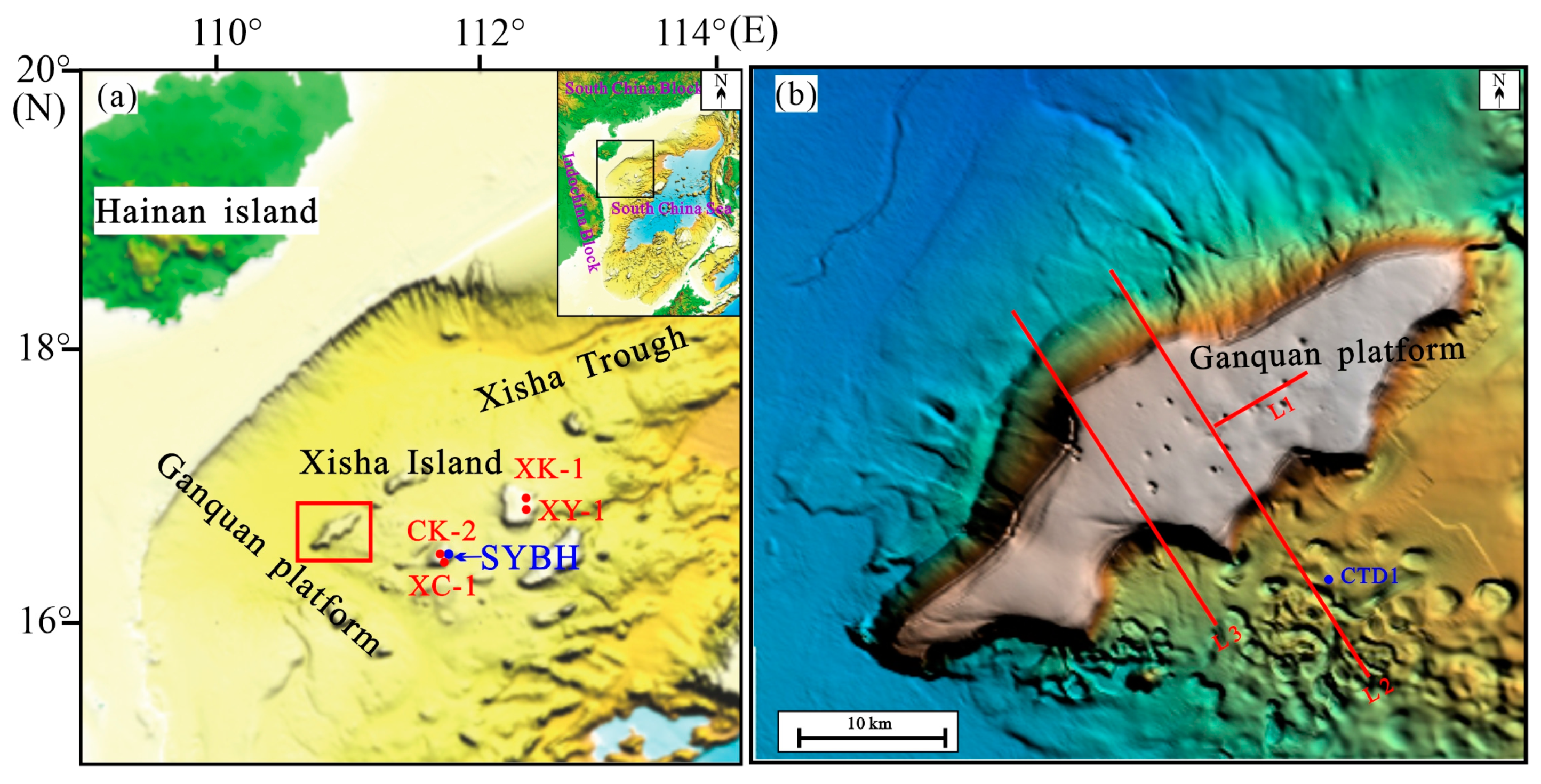
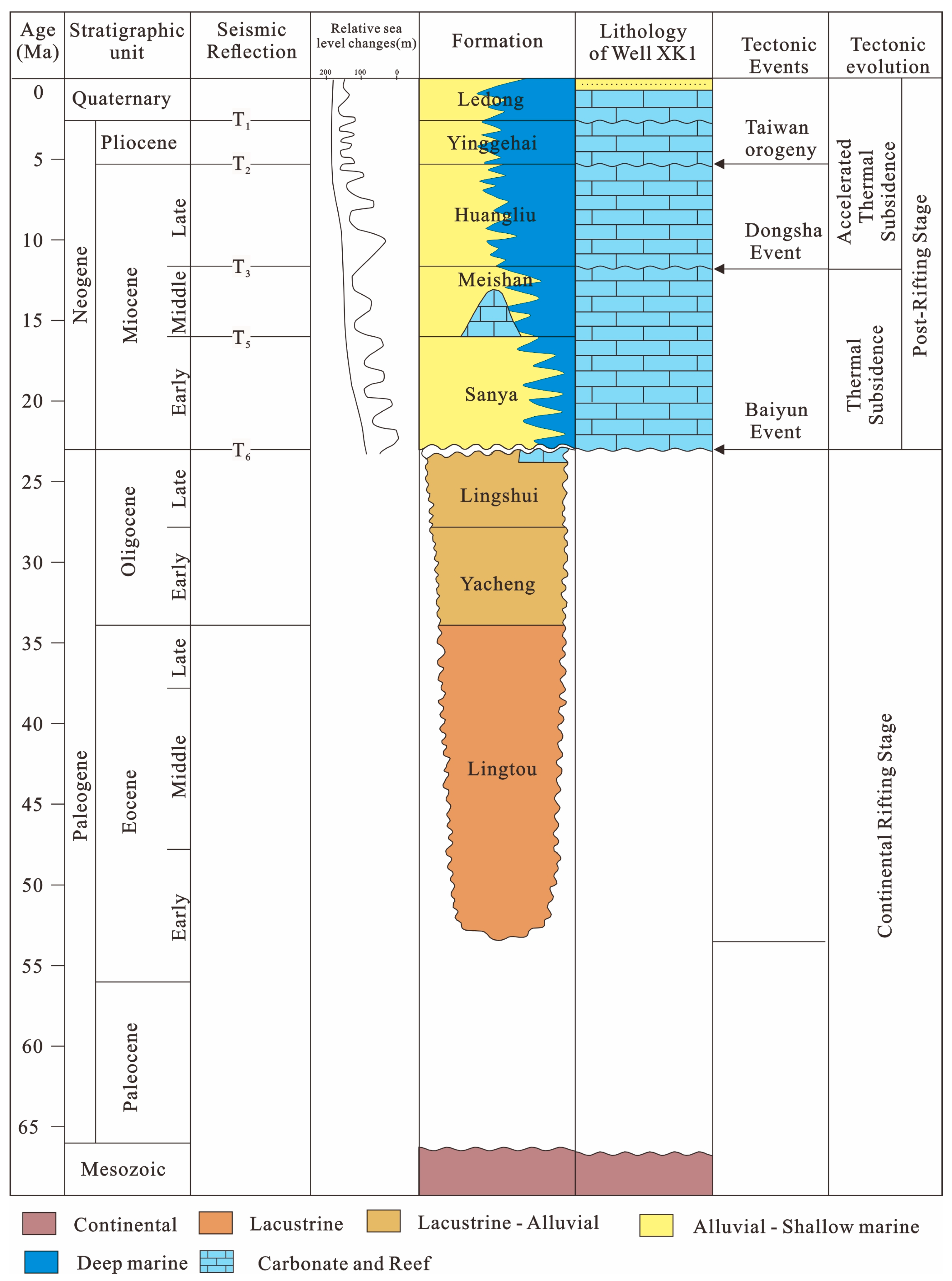
2. Geological Background

The SCS is one of the largest marginal seas in the western Pacific Ocean, covering 3.5 × 10⁶ km2 [17]. It has undergone a complex tectonic evolution, which can be divided into the following three stages: the rifting stage (from the Paleocene to early Oligocene), the seafloor spreading stage (from the late Oligocene to early Miocene), and post-seafloor spreading stage (from the middle Miocene to Quaternary) [18,19]. Cenozoic magmatism occurred extensively in the SCS and can generally be divided into the following three stages: rifting, seafloor spreading, and post-seafloor spreading [20]. The widely distributed carbonate platforms exhibit large thicknesses and obvious spatiotemporal variations in the SCS [21]. Statistical data from previous studies have shown that there are ca. 128 atolls with an approximate area of ~8000 km2 in the SCS at present [22].
The Xisha Islands are located on the Xisha Uplift of the northwest SCS, and their water depth varies greatly from tens to thousands of meters (Figure 1). The Xisha Uplift has been separated from South China and the Indochina mainland by deep-water troughs since the early Miocene and is far from terrigenous sediment sources, which are unable to strongly affect the Xisha carbonate platform. Previous studies have shown that carbonate deposits are sufficiently developed on the faulted blocks and volcanic seamounts of the Xisha Uplift from the Eocene to the present [21]. A series of scientific wells, including XC-1, XY-1, XK-1, and CK-2, are located near the Xisha Islands (Figure 1a), revealing that a vast reef formation has developed in the basement since the Miocene (Figure 2). Post-spreading magmatism occurred intensely in the Xisha Uplift from the late Miocene, and tectonic subsidence and magmatic intrusion probably controlled the development and drowning of the Xisha carbonate platforms [15]. The Xisha carbonate platforms have experienced four stages of evolution, including initiation (early Miocene), flourishing (middle Miocene), drowning (late Miocene), and relict (Pliocene to the present) [23]. Most of the isolated carbonate platforms were drowned in the late Cenozoic (and are now considered drowned carbonate platforms [15]). Our study area, the Ganquan platform, is located west of the Xisha Islands. It is a typical drowned, isolated carbonate platform. New evidence from a foraminifer and stratigraphic correlation showed that it was drowned during the middle of the Miocene [16].

3. Data and Methods

The multibeam bathymetric data used in this study were acquired in 2021 via GMGS and were obtained using the EM 122 echosounder system. Raw bathymetric data were processed using Caris HIPS, and the major processing steps included navigation and sound-speed corrections, noise elimination, and the preservation of various seafloor microgeomorphic features. The cell size of the raster grids was ca. 20 m. The error was 0.6 m when the water depth was less than 30 m, and it was 2‰ when the water depth was greater than 30 m. They were used to identify the geomorphologic parameters of the submarine sinkholes (e.g., water depth, depression depth, average diameter, etc.) on the Ganquan platform.
The shallow formation profile measurement used the Atlas Parasounnd P70 type shallow formation profiler. The recorded formation reflection signal was coherent and clear, and the formation reflection interface layer was clear and easy to trace continuously. The penetration depth of the shallow formation profile in the study area reached 30 m with a maximum value of 150 m. A multichannel time-migrated seismic profile was acquired in 2020. The seismic source was a bigshot gun with a total volume of 4740 in3 towed at a depth of 7 m. The working pressure was 1,262,000 PSI. Its common midpoint (CMP) was 12.5 m with a record length of 9.1 s (two-way travel time, hereafter TWTT) and an I confirm average sonic velocity of 2500 m/s for the carbonates. The seismic profile was interpreted with Geoframe 4.4. Seismic profiles are used to identify the seismic reflection characteristics of submarine sinkholes to discuss their origins.

4. Results

4.1. Morphology of the Ganquan Platform

Generally, the spindle-shaped Ganquan platform is oriented NE, has a flat top, and extends ~48.3 km (Figure 1b and Figure 3). It is wide in the middle part (~14.7 km) and narrow at both ends (~0.2 km). Its total area is ~424 km2. The water depths at the top of the platform range from 559 to 687 m and the average water depth of the outer platform edge is ~1200 m, with a relative elevation difference of ~500 m from the platform top to the edges. Its average slopes are less than 0.08°, but its southeastern slope is steeper than its western and northern slopes (Figure 3).

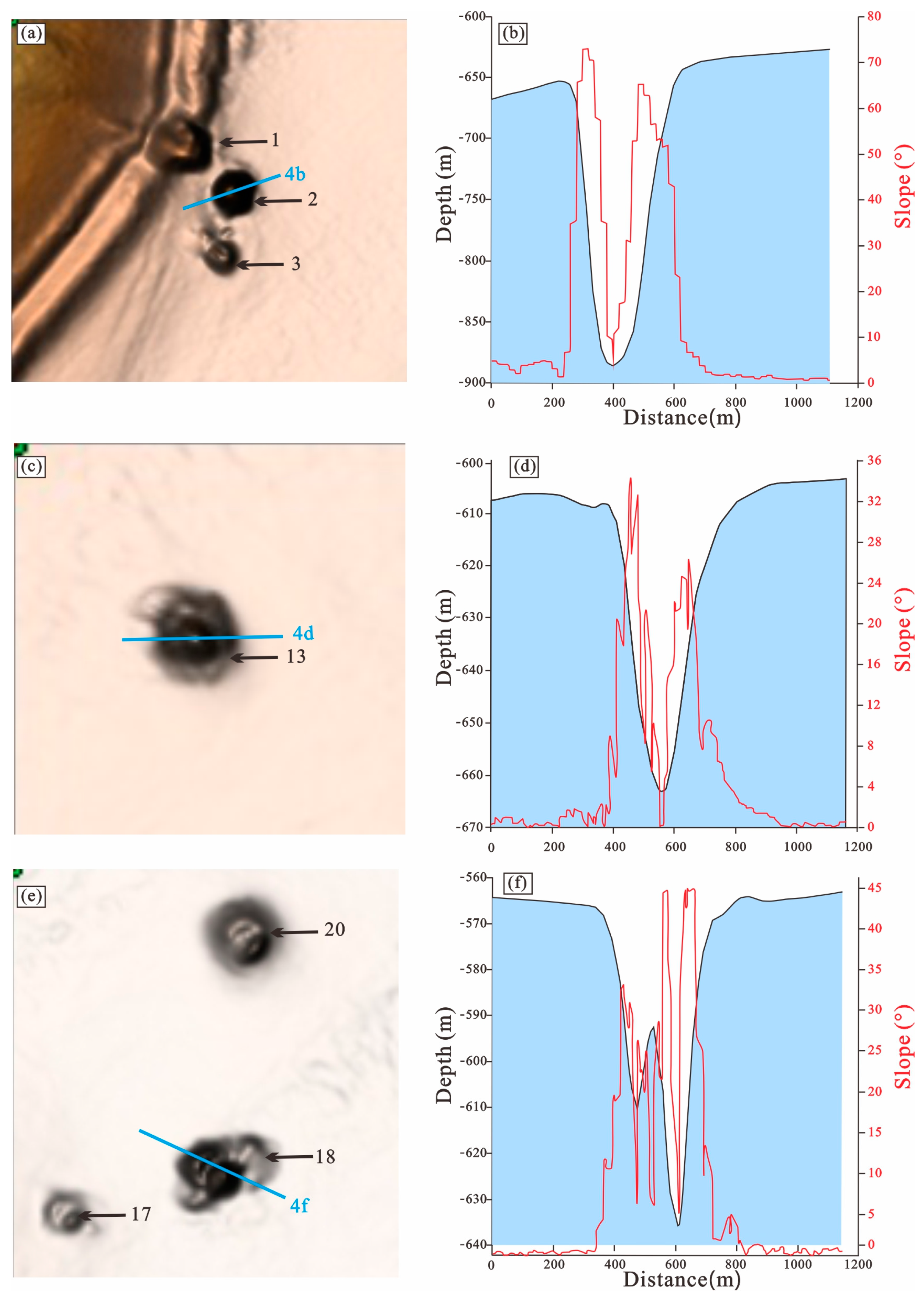
4.2. Distribution and Morphologies of Submarine Sinkholes

Thirty-seven submarine sinkholes were identified on the Ganquan platform’s top and edges according to the high-resolution multibeam bathymetric map (Figure 3 and Figure 4). Among them, 32 were distributed on the top of the Ganquan platform, while five were distributed at the platform edges. The distribution density of these submarine sinkholes was ca. 8–9/100 km2. They present irregular circular or subcircular shapes oriented in the SW–NE direction and are nearly parallel to the long-axis direction of the Ganquan platform. A brief account of the morphological parameters of the submarine sinkholes, including water depth, depression depth, length, width, and average diameters, is presented below (Figure 3 and Figure 4; Table 1).
Although the water depths of the submarine sinkholes ranged from 550 to 1267 m, most of them were between 550 and 750 m. The vertical interior depth of these depressions ranged from 2.5 to 241 m, with a main range of 2.5–50 m. Their diameters ranged from 57 to 667 m, with an average diameter of 334 m (Table 1). Their cross sections show that the inner walls of these submarine sinkholes have steep angles on both sides ranging from 6° to 45° and are asymmetrically V- and compound V-shaped (Figure 4).

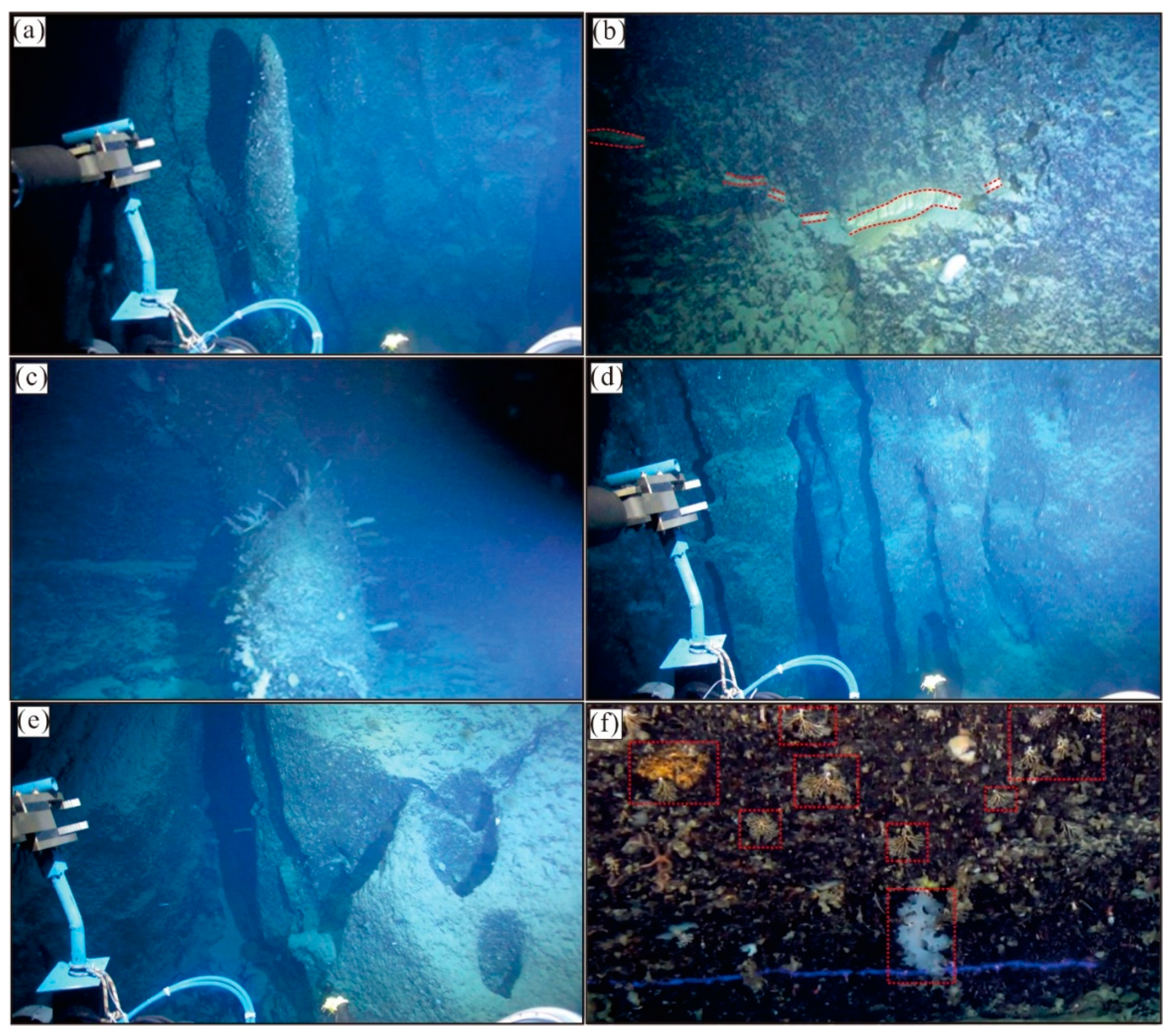
4.3. ROV Observations

ROV Haima 2 observed the inner walls of submarine sinkhole No. 2 (Figure 5), in which the bottom depth is 883 m. The observation images showed that the inner wall of this depression is irregular, and a large amount of white foraminiferal sand (fine coral debris, algae, and microscopic organisms) is present at the bottom. Variable characteristics are observed on the inner wall, including stalactite-like structures (Figure 5a,c), possible dikes (Figure 5b), flow marks (Figure 5d), and corroded holes (Figure 5e). In addition, a variety of marine organisms, such as jellyfish and cold corals, are found at various depths in these submarine sinkholes (Figure 5a,c,f), presenting abundant ecological resources contained in this unique semi-enclosed environment.

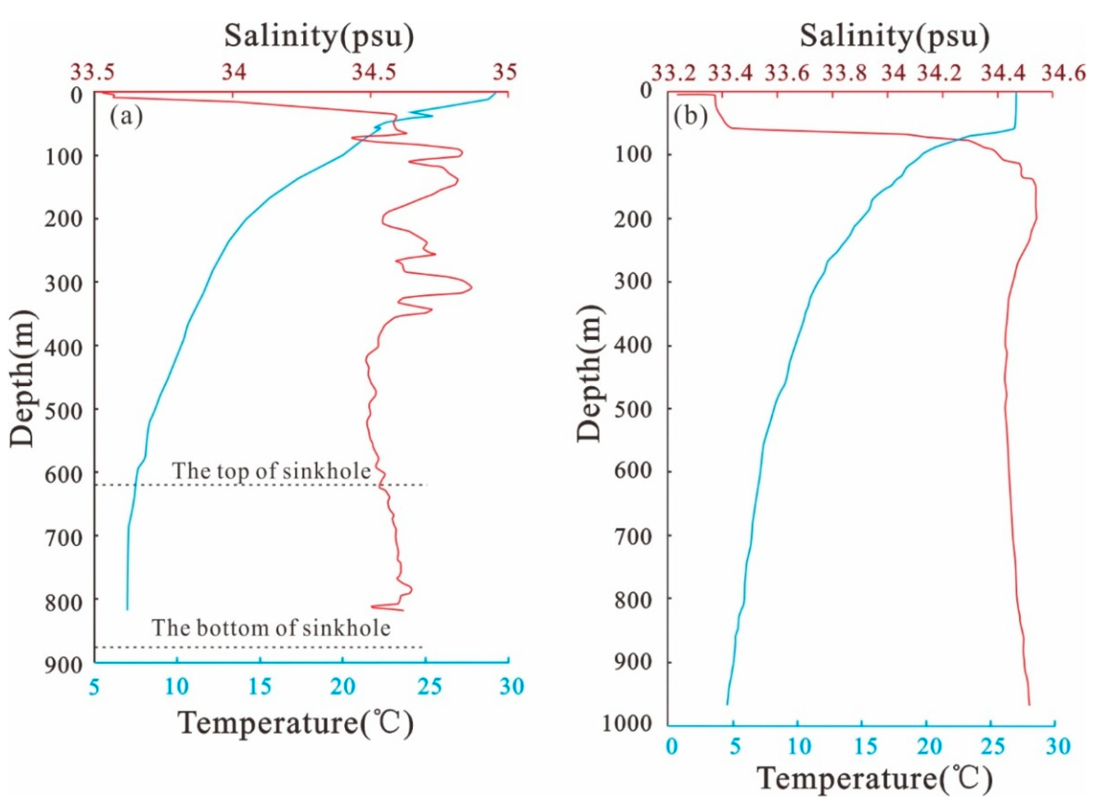
4.4. Hydrological Features

The temperature and salinity profiles show that the water column above submarine sinkhole No. 2 and the water column in the open sea have clearly stratified systems that are slightly different from each other (Figure 6a,b). The obvious stratification change in submarine sinkhole No. 2 was located at a depth of 30 m, where the temperature decreased from 29 to 23 °C and the salinity increased from ~33.5 to 34.6 psu. The clear stratification change in the open sea was located at a depth of 55 m, where the temperature decreased from 26 to 22 °C and the salinity increased from 33.2 to 34.3 psu. Toward the top (642 m deep) of submarine sinkhole No. 2, the temperature gradually decreased from 23 to 8 °C, with numerous haloclines resulting in a change between 34.5 and 34.9 psu (Figure 6a). Correspondingly, the temperature gradually decreased from 22 to 7 °C, and the salinity slightly increased from 34.3 to 34.5 psu and then decreased to 34.4 psu in the open sea (Figure 6b). The bottom (883 m deep) of submarine sinkhole No. 2 featured a temperature of approximately 7 °C and a salinity of 34.6 psu, whereas the open ocean at the same depth featured a temperature of approximately 5 °C and a salinity of 34.5 psu, showing that the temperature of submarine sinkhole No. 2 was 2 °C higher than that of the open ocean at the same depth and that these salinities were similar (Figure 6a,b).
The dissolved oxygen (DO) concentration was 6 mg/L in the surface water, which increased to 8 mg/L at a 30 m depth and dramatically decreased to 3 mg/L at the top of submarine sinkhole No. 2 (Figure 7). The DO concentration slightly decreased to 2.8 mg/L at the bottom of submarine sinkhole No. 2.

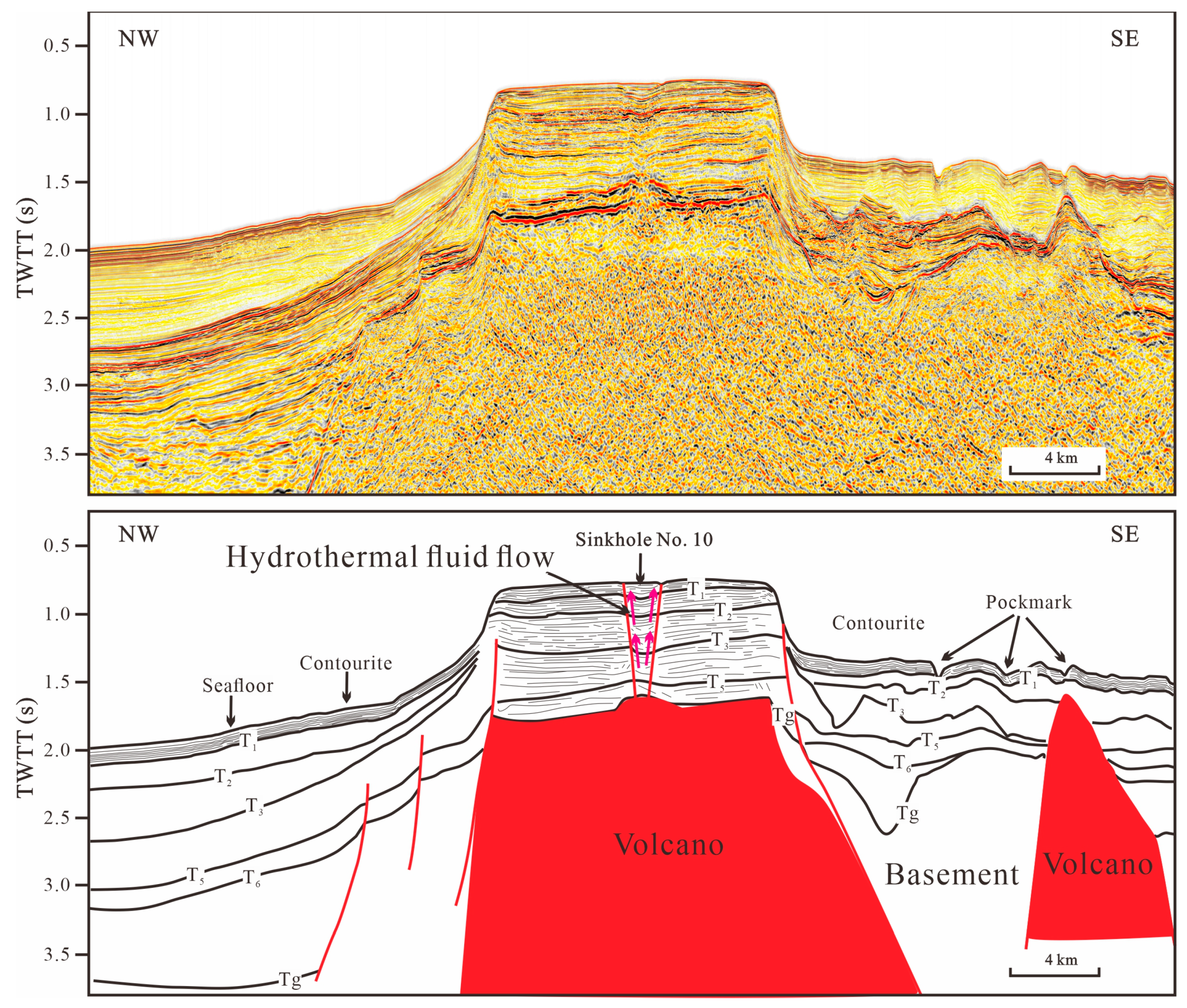
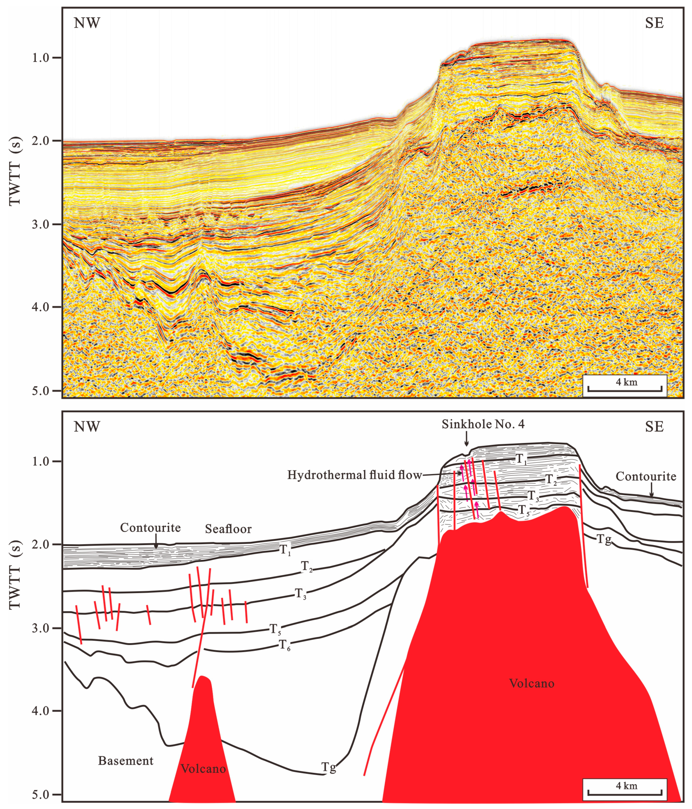
4.5. Seismic Reflection Characteristics

The shallow formation profile across the submarine sinkholes of No. 16 and No. 20 showed V shapes similar to those imaged via multibeam bathymetric profiles (Figure 4b,d and Figure 8). The seafloor was characterized by continuous, high-amplitude, and low-frequency seismic reflections, while the interior of the carbonate platform had no obvious seismic reflections, similar to the seawater body. The inner wall of submarine sinkhole No. 16 was characterized by inclined, low- to moderate-amplitude, and low-frequency seismic reflections, while that of submarine sinkhole No. 20 showed low-amplitude and chaotic seismic reflections. There are strongly discontinuous, moderate-to-high amplitude, and low-frequency seismic reflections beneath the two sinkholes (Figure 8). Acidic hydrothermal fluids produced via magmatic activity dissolve carbonate, causing stratum sinking. The seismic profile associated with dissolution showed high-amplitude anomalies.
The multichannel seismic profile shows that the carbonate platform is characterized as subparallel to parallel, relatively continuous to continuous, moderate-to-high amplitude with low-to-moderate frequency seismic reflections (Figure 9). A depression was imaged in the middle platform and exhibited concave-folded seismic reflections from 0.8 to 1.5 s (TWTT) in depth. Acidic hydrothermal fluids dissolved the upper formation and caused a collapse phenomenon, which is the reason why seismic reflections show concave folding. Due to magmatic activity intruding on the overlying strata, seismic reflections appear folded upward from 1.5 to 1.7 s (TWTT) in depth (Figure 9).
Figure 10 shows that the seismic profile crosses submarine sinkhole No. 4, which is also identified using the multibeam bathymetric map. Ganquan carbonate sequences display parallel continuous reflections and overlap the basement from the middle Miocene (T5). An upward-bounded solution feature forms at the top of the volcano from 1.5 to 1.7 s (TWTT) in depth and has chaotic discontinuous seismic reflection characteristics in Figure 10. This means acidic hydrothermal fluids caused by volcanoes flow upward and dissolve carbonate formations along faults.

5. Discussion

5.1. Nature of the Submarine Sinkholes

Our high-resolution multibeam bathymetric data showed well-developed submarine sinkholes on the Ganquan carbonate platforms (Figure 3). ROV Haima 2 imaged corals (Figure 5a,c), flow marks (Figure 5e), and corroded holes (Figure 5f) in the inner wall of submarine sinkhole No. 2, indicating that these submarine sinkholes show strong morphologic similarities (e.g., size, depth, and shape) with those developed on other carbonate platforms worldwide, such as the southern Florida Straits [8,9,10], southern Adriatic Sea [11], Abrolhos Bank of Australia [12,13], and the Bahamas and Caribbean Seas [7,14].

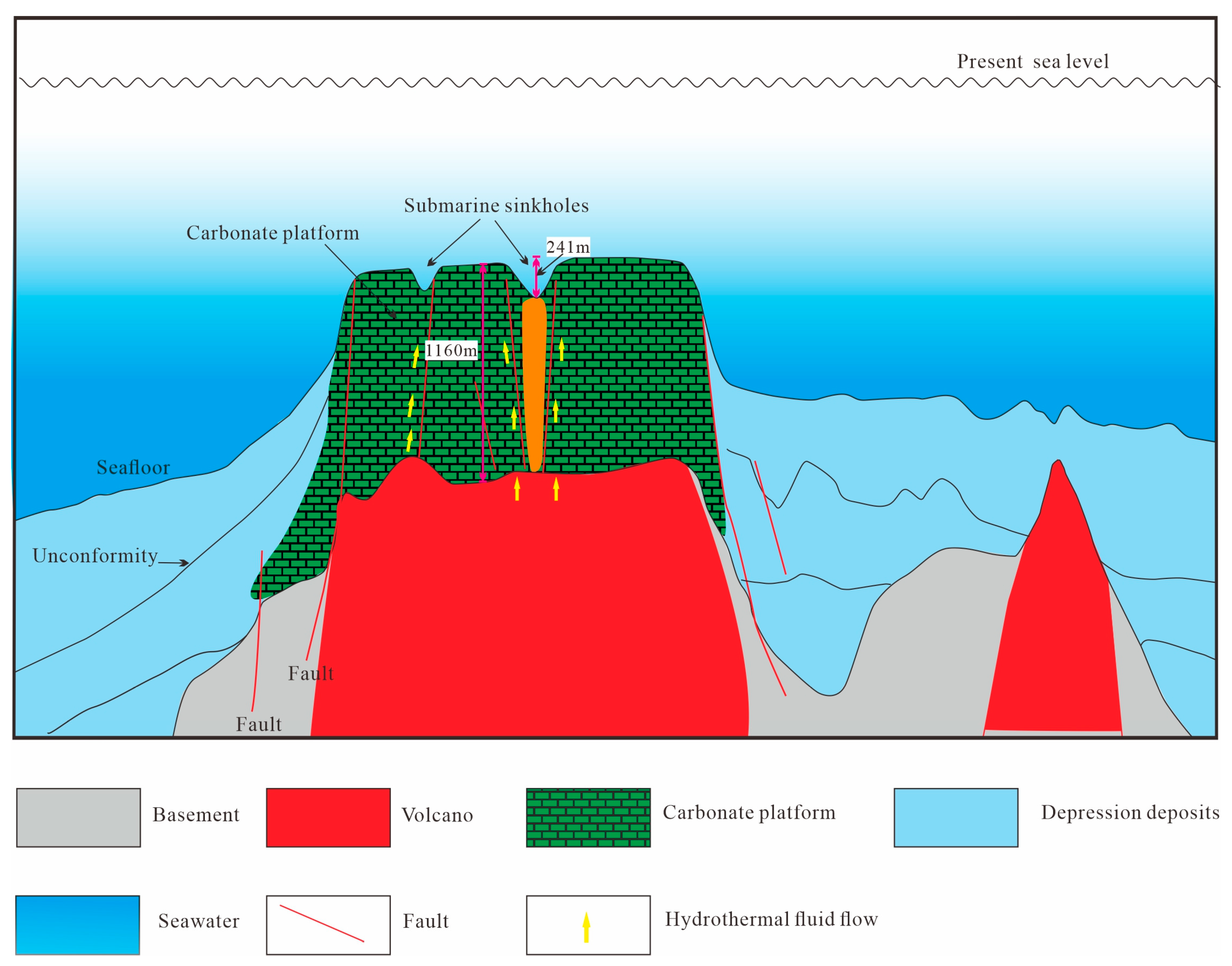
5.2. Origins of the Submarine Sinkholes in the Ganquan Platform

Most sinkholes globally are thought to have resulted from the dissolution of carbonate platforms caused by fresh meteoric groundwater rich in CO2 in a subaerial environment [24,25]. Submarine sinkholes in marine environments are also related to tectonic uplift or sea level drop, such as in Florida, Japan, Belize, Mexico, and the Mediterranean [6,9]. However, in areas where subsurface waters with different compositions mix, solution–collapse sinkholes in carbonate platforms may have never been subaerially exposed. Land and Paull [10] proposed that the collapse of carbonate rocks resulted from the mixing of deep freshwater and seawater near land in the Florida Straits because the sea level could not have dropped by 600 m to expose the surface. Michaud et al. [26] deduced that the dissolution of carbonate rocks was caused by underlying thermal convection derived from volcanic or basement hydrothermal systems.
A recent study showed that the Ganquan platform was drowned during the middle Miocene [16] when most other Xisha carbonate platforms were in a flourishing stage (middle Miocene) and were later drowned in the late Miocene [15,27]. Hence, there is little chance that the Ganquan platform experienced a subaerial environment with fresh meteoric dissolution. By contrast, the Xisha Uplift experienced multiple phases of magmatic activity in the Cenozoic [19,28]. In particular, massive magmatic intrusions and volcanic eruptions occurred in the Xisha Uplift during the early Pliocene, and this magmatism phase was considered the most intense [29]. A large amount of hydrothermal fluid was produced by magmatism and resulted in the strong dolomitization of strata in the Upper Miocene [30]. Furthermore, magmatic activity can increase the temperature of acidic fluid and accelerate the dissolution rate of carbonate rocks [31,32].
Our shallow formation profile showed that columnar zones below submarine sinkholes are characterized by highly discontinuous or disturbed reflections with vertically to subvertically stacked amplitude anomalies (Figure 8), which have been indicated as pipes in previous studies [33,34]. By contrast, our multichannel seismic profiles showed that some pipes may be derived from the basement of the carbonate platform rather than from the sediments (Figure 11), which is similar to hydrothermal pipes developed around the Yongle carbonate platform. Additionally, the flow marks and corroded holes imaged by ROV Haima 2 indeed indicate fluid flow activity in submarine sinkholes (Figure 5e,f). Possible dikes also indicate that hydrothermal fluid flow activity from the deep basement was involved in the dissolution process of the carbonate platform (Figure 5b). Acidic hydrothermal fluids flow upward through faults to dissolve carbonate formations, and the carbonate strata at the top of the sinkhole cannot bear the load of the upper strata and collapse, resulting in the formation of a sinkhole (Figure 11). Based on the analysis above, we propose that the submarine sinkholes originated from the dissolution of the Ganquan carbonate platform via acidic hydrothermal fluids produced by magmatic activity.

6. Conclusions

1.
Based on high-resolution multibeam bathymetry data and geophysical data, 37 submarine sinkholes were discovered for the first time in the Ganquan platform of the Xisha Islands in the northwestern SCS, and their water depths range from 550 to 1267 m. They are probably the largest submarine sinkholes developed in an isolated carbonate platform worldwide.
2.
Analyses of the temperature, salinity, and dissolved oxygen in the submarine sinkholes showed that the temperature of submarine sinkholes is 2 °C higher than that of the open ocean at the same water depth. In addition, the inner walls of submarine sinkholes are characterized by stalactite-like structures, possible dikes, flow marks, and corroded holes, which are typical karstic landscape features. These results may indicate that submarine sinkholes contain distinctive microbial communities based on variations in marine environmental conditions.
3.
This study proposes that submarine sinkholes were formed by acidic hydrothermal fluids produced from magmatic activity below the Ganquan platform. The hydrothermal fluids probably flowed upward along faults and dissolved the carbonate platform.

Author Contributions

Conceptualization, W.D., C.Y. and H.Z.; Formal analysis, H.Z.; Supervision, C.Y.; Methodology, X.H.; Visualization, C.Y. and J.G.; Data curation, X.H., Z.X., X.N. and R.Z.; Investigation, M.W.; Writing—original draft, W.D.; Writing—review and editing, C.Y. and J.G. All authors have read and agreed to the published version of the manuscript.

Funding

This work was funded by the China Geological Survey Project, grant numbers DD20221712 and DD20221719.

Institutional Review Board Statement

Not applicable.

Informed Consent Statement

Not applicable.

Data Availability Statement

All data have been provided in this paper. Further inquiries can be directed to the corresponding authors.

Acknowledgments

The authors wish to thank all crew members for their efforts in acquiring the data used in this study.

Conflicts of Interest

The authors declare no conflict of interest.

References

  1. Jordan, G.F. Large sinkholes in Straits of Florida. American Association of Petroleum. Geol. Bull. 1954, 38, 1810–1817. [Google Scholar]
  2. Jordan, G.F.; Malloy, R.J.; Kofoed, J.W. Bathymetry and geology of Pourtalès Terrace, Florida. Mar. Geol. 1964, 1, 259–287. [Google Scholar] [CrossRef]
  3. Gutiérrez, F.; Guerrero, J.; Lucha, P. A genetic classification of sinkholes illustrated from evaporite paleokarst exposures in Spain. Environ. Geol. 2008, 53, 993–1006. [Google Scholar] [CrossRef]
  4. Yechieli, Y.; Abelson, M.; Baer, G. Sinkhole formation and subsidence along the Dead Sea coast, Israel. Hydrogeol. J. 2015, 24, 601–612. [Google Scholar] [CrossRef]
  5. Backshall, D.G.; Barnett, J.; Davies, P.J.; Duncan, D.C.; Harvey, N.; Hopley, D.; Isdale, P.J.; Jennings, J.N.; Moss, R. Drowned dolines—The blue holes of the Pompey Reefs, Great Barrier Reef. J. Aust. Geol. Geophys. 1979, 4, 99–109. [Google Scholar]
  6. Hengstum, P.; Scott, D.B.; Grocke, D.R.; Charette, M.A. Sea level controls sedimentation and environments in coastal caves and sinkholes. Mar. Geol. 2011, 286, 35–50. [Google Scholar] [CrossRef]
  7. Cavailhes, T.; Gillet, H.; Guiastrennec-Faugas, L.; Mulder, T.; Hanquiez, V. The abyssal giant sinkholes of the Blake Bahama Escarpment: Evidence of focused deep-ocean carbonate dissolution. Geomorphology 2022, 398, 108058. [Google Scholar] [CrossRef]
  8. Kohout, F.A. Ground-water flow and the geothermal regime of the Floridian Plateau. Gcags Trans. 1967, 17, 339–354. [Google Scholar]
  9. Land, L.A.; Paull, C.K.; Hobson, B. Genesis of a submarine sinkhole without subaerial exposure: Straits of Florida. Geology 1995, 23, 949–951. [Google Scholar] [CrossRef]
  10. Land, L.A.; Paull, C.K. Submarine karst belt rimming the continental slope in the Straits of Florida. Marine Geology. Letters 2000, 20, 123–132. [Google Scholar]
  11. Taviani, M.; Angeletti, L.; Campiani, E.; Ceregato, A.; Foglini, F.; Maselli, V.; Morsilli, M.; Parise, M.; Trincardi, F. Drowned karst landscape offshore the Apulian margin (Southern Adriatic Sea, Italy). J. Cave Karst Stud. Natl. Speleol. Soc. Bull. 2012, 74, 197–212. [Google Scholar] [CrossRef]
  12. Bastos, A.C.; Amado-Filho, G.M.; Moura, R.L.; Sampaio, F.M.; Bassi, D.; Braga, J.C. Origin and sedimentary evolution of sinkholes (buracas) in the abrolhos continental shelf, Brazil. Palaeogeogr. Palaeoclimatol. Palaeoecol. 2016, 462, 101–111. [Google Scholar] [CrossRef]
  13. Bastos, A.C.; Moura, R.L.; Amado-Filho, G.M.; D’Agostini, D.P.; Secchin, N.A.; Francini-Filho, R.B.; Guth, A.Z.; Sumida, P.Y.G.; Mahiques, M.M.; Thompson, F.L.; et al. Buracas; novel and unusual sinkhole-like features in the Abrolhos Bank. Cont. Shelf Res. 2013, 70, 118–125. [Google Scholar] [CrossRef]
  14. Humphreys, M.P.; Meesters, E.H.; De Haas, H.; Karancz, S.; Delaigue, L.; Bakker, K.; Duineveld, G.; De Goeyse, S.; Haas, A.F.; Mienis, F.; et al. Dissolution of a submarine carbonate platform by a submerged lake of acidic seawater. Biogeosciences 2022, 19, 347–358. [Google Scholar] [CrossRef]
  15. Wu, S.; Zhang, X.; Yang, Z.; Wu, T.; Gao, J.; Wang, D. Spatial and temporal evolution of Cenozoic carbonate platforms on the continental margins of the South China Sea: Response to opening of the ocean basin. Interpretation 2016, 4, SP1–SP19. [Google Scholar] [CrossRef]
  16. Chen, W.; Wu, S.; Wang, D.; Betzler, C.; Ma, Y. Stratigraphic evolution and drowning steps of a submerged isolated carbonate platform in the northern South China Sea. Front Mar. Sci. 2023, 10, 1200788. [Google Scholar] [CrossRef]
  17. Zhu, S.; Li, X.; Zhang, H.; Sha, Z.; Sun, Z. Types, characteristics, distribution, and genesis of pockmarks in the South China Sea: Insights from high-resolution multibeam bathymetric and multichannel seismic data. Int. Geol. Rev. 2020, 63, 1–21. [Google Scholar] [CrossRef]
  18. Song, X.; Li, C.F.; Yao, Y.; Shi, H. Magmatism in the evolution of the South China Sea: Geophysical characterization. Mar. Geol. 2017, 394, 4–15. [Google Scholar] [CrossRef]
  19. Xie, X.; Ren, J.; Wang, Z.; Li, X.; Lei, C. Difference of tectonic evolution of continental marginal basins of South China Sea and relationship with SCS spreading. Earth Sci. Front 2015, 22, 77–87. [Google Scholar]
  20. Zhang, Q.; Wu, S.; Dong, D. Cenozoic magmatism in the northern continental margin of the South China Sea: Evidence from seismic profiles. Mar. Geophys. Res. 2016, 37, 71–94. [Google Scholar] [CrossRef]
  21. Ma, B.; Qin, Z.; Wu, S.; Cai, G.; Li, X.; Wang, B.; Liu, X.; Qin, Y.; Huang, X. High-resolution acoustic data revealing peri-platform sedimentary characteristics in the Xisha archipelago, South China Sea. Interpretation 2021, 9, T533–T547. [Google Scholar] [CrossRef]
  22. Wu, F.; Xie, X.; Li, X.; Coletti, G.; Bwtzler, C.; Cui, Y.; Bai, H.; Chen, B.; Shang, Z. Early development of carbonate platform (xisha islands) in the northern South China Sea. Mar. Geol. 2021, 441, 106629. [Google Scholar] [CrossRef]
  23. Liu, Y.; Wu, S.; Li, X.; Chen, W.; Han, X.; Yang, C.; Qin, Y.; Huang, X.; Yang, Z.; Sun, J.; et al. Seismic stratigraphy and development of a modern isolated carbonate platform (Xuande atoll) in the South China Sea. Front. Earth Sci. 2023, 10, 1042371. [Google Scholar] [CrossRef]
  24. Mylroie, J.E. Late Quaternary sea-level position: Evidence from Bahamian carbonate deposition and dissolution cycles. Quat. Int. 2008, 183, 61–75. [Google Scholar] [CrossRef]
  25. Mylroie, J.E.; Carew, J.L.; Moore, A.I. Blue holes: Definitions and genesis. Carbonates Evaporites 1995, 10, 225–233. [Google Scholar] [CrossRef]
  26. Michaud, F.; Chabert, A.; Collot, J.Y.; Sallarès, V.; Flueh, E.R.; Charvis, P.; Graindorge, D.; Gustcher, M.-A.; Billas, J. Fields of multi-kilometer scale sub-circular depressions in the Carnegie Ridge sedimentary blanket: Effect of underwater carbonate dissolution. Mar. Geol. 2005, 216, 205–219. [Google Scholar] [CrossRef]
  27. Wu, S.; Yang, Z.; Wang, D.; Lü, F.; Lüdmann, T.; Fulthorpe, C.; Wang, B. Architecture, development and geological control of the Xisha carbonate platforms, northwestern South China Sea. Mar. Geol. 2014, 350, 71–83. [Google Scholar] [CrossRef]
  28. Wang, H.; Zhao, Q.; Wu, S.; Wang, D.; Wang, B. Post-rifting magmatism and the drowned reefs in the Xisha Archipelago domain. J. Ocean Univ. China 2018, 17, 195–208. [Google Scholar] [CrossRef]
  29. Du, W.B.; Cai, G.Q.; Huang, W.K.; Chen, J.L.; Nie, X.; Wan, X.M. Seismic reflection characteristics of Neogene carbonate in the Xisha Sea area and their controlling factors. Mar. Geol. Front. 2021, 37, 20–30, (In Chinese with English abstract). [Google Scholar]
  30. Zhao, M.; Yu, K.; Shi, Q.; Yang, H.; Riegl, B.; Zhang, Q.; Yan, H.; Chen, T.; Liu, G.; Lin, Z. The coral communities of Yongle atoll: Status, threats and conservation significance for coral reefs in South China Sea. Mar. Freshw. Res. 2016, 67, 1888–1896. [Google Scholar] [CrossRef]
  31. Cornet, T.; Cordier, D.; Le Bahers, T.; Bourgeois, O.; Fleurant, C.; Le Mouélic, S.; Altobelli, N. Dissolution on Titan and on Earth: Toward the age of Titan’s karstic landscapes. J. Geophys. Res. Planets 2015, 120, 1044–1074. [Google Scholar] [CrossRef]
  32. Zhang, K.; Guan, Y.; Song, H.; Fan, W.; Li, H.; Kuang, Y.; Geng, M. A preliminary study on morphology and genesis of giant and mega pockmarks near Andu seamount, Nansha Region (South China Sea). Mar. Geophys. Res. 2020, 41, 2. [Google Scholar] [CrossRef]
  33. Cartwright, J.; Huuse, M.; Aplin, A. Seal Bypass Systems. AAPG Bull. 2007, 91, 1141–1166. [Google Scholar] [CrossRef]
  34. Moss, J.L.; Cartwright, J. 3D seismic expression of km-scale fluid escape pipes from offshore Namibia. Basin Res. 2010, 22, 481–501. [Google Scholar] [CrossRef]
Figure 1. Location map of the study area in the northern South China Sea. (a) Regional bathymetric maps showing the location of the Xisha Islands. The upper right inset shows the location of the northwestern SCS. The red rectangle is the study area. Red solid circles represent the locations of scientific wells. The blue solid circle marks the location of the Sansha Yongle blue hole (SYBH). (b) Multibeam bathymetric map showing the geomorphology of the Ganquan platform. Red lines represent the locations of the shallow formation profile and multichannel seismic profiles. See (a) for location.
Jmse 11 02171 g001
Figure 2. Comprehensive stratigraphic column of the Qiongdongnan Basin and Xisha Islands in the northwestern SCS.
Jmse 11 02171 g002
Figure 3. High-resolution multibeam bathymetric map of the Ganquan platform showing the locations of 37 submarine sinkholes. See Figure 1a for location. The numbers with black lines mark the locations of the submarine sinkholes.
Jmse 11 02171 g003
Figure 4. Detailed views of typical submarine sinkholes with high-resolution multibeam bathymetric maps (a,c,e) and cross sections (b,d,f). See Figure 3 for locations. Submarine sinkholes No. 2, No. 13, and No. 18 are V-shaped and compound V-shaped. The numbers with black lines mark the locations of submarine sinkholes. Blue lines mark the locations of cross sections of submarine sinkholes No. 2, No. 13, and No. 18.
Jmse 11 02171 g004
Figure 5. Observation images of ROV Haima 2 of the inner walls and bottom of submarine sinkholes No. 2. (a) A vertical stalactite-like structure. (b) The possible dikes (marked by dashed red lines) developed in the inner wall. (c) Corals developed on a horizontal stalactite-like structure. (d) Flow marks in the inner wall. (e) The corroded holes in the inner wall. (f) Cold water coral.
Jmse 11 02171 g005
Figure 6. Vertical profiles of temperature and salinity. (a) Submarine sinkhole No. 2. (b) CTD 1 (open ocean).
Jmse 11 02171 g006
Figure 7. Vertical profiles of dissolved oxygen (DO) of submarine sinkhole No. 2.
Jmse 11 02171 g007
Figure 8. Shallow formation profile of L1 and its interpretation crossing sinkholes No. 16 and No. 20. TWTT: Two-way travel time. See Figure 1b for location.
Jmse 11 02171 g008
Figure 9. Multichannel seismic profile of L2 and its interpretation crossing sinkhole No. 10. TWTT: Two-way travel time. See Figure 1b for location.
Jmse 11 02171 g009
Figure 10. Multichannel seismic profile of L3 and its interpretation crossing sinkhole No. 4. TWTT: Two-way travel time. See Figure 1b for location.
Jmse 11 02171 g010
Figure 11. A cartoon model illustrating the formation of submarine sinkholes in the Ganquan platform.
Jmse 11 02171 g011
Table 1. Measured geomorphologic parameters of submarine sinkholes.
No.Water
Depth (m)
Top
Water Depth (m)
Bottom
Depression Depth (m)Length (m)Length
Orientation (°N)
Width (m)Width Orientation (°N)Average Diameter (m)
172477854596132.9354544.85572
2642883241483175.4236983.53449
36476934635489.86301138.11330
459165564453197.05371121.25441
55936839066766.2550443.33566
659862426489176.6639283.85465
75976515447462.06388150.21435
85866728658257.79380147.85459
958663145261135.2623742.56252
105736628960260.57427156.26501
115996202135947.93258142.67320
1261369178360133.1632847.21339
1360967869503141.8541454.14468
1458070012054663.64456124.96487
1558260725506172.3535180.06416
165805991961091.75462183.47519
1757159322408132.0932943.75333
185716507969656.55418153.16550
1956157514295140.0728748.81293
2057162756542157.5349966.64502
2159567681626154.6557162.48574
22550.55565.515271.22113176.2172
23596.56058.521490.6821119.23213
24559.25633.828530.79234131.34267
251267.3128214.735140.6830898.26321
261242.3125411.736386.9327178.94338
27821.286341.8263179.6324089.01264
287767982221859.98195150.9207
29583.55862.530561.5213168268
30589.85966.222931208121214
31593.15962.9150167.1142.888.1148
32600.76043.3201118.815745.6180
33704.17094.9151.4204137117143.6
34794799517710497191145
3511011115141092277814995
361089111526832293813066
371143115916882315714576
Disclaimer/Publisher’s Note: The statements, opinions and data contained in all publications are solely those of the individual author(s) and contributor(s) and not of MDPI and/or the editor(s). MDPI and/or the editor(s) disclaim responsibility for any injury to people or property resulting from any ideas, methods, instructions or products referred to in the content.

