Article

Systematization of Legal Procedures for Collision Avoidance between a Fully Autonomous Ship and a Traditional Manned Ship

Division of Navigation and Information Systems, Mokpo National Maritime University, Mokpo 58628, Republic of Korea
J. Mar. Sci. Eng. 2023, 11(10), 1850; https://doi.org/10.3390/jmse11101850
Submission received: 20 August 2023 / Revised: 21 September 2023 / Accepted: 21 September 2023 / Published: 22 September 2023

Abstract

:
Discussions of autonomous ships are actively being conducted in the industry and by the International Maritime Organization (IMO). In addition, it is anticipated that a significant number of autonomous ships will be operational at sea soon, as a trial run of autonomous ships is underway. Fully autonomous ships will operate based on pre-programmed algorithms to prevent collisions, eliminating the need for onboard navigators or remote operators onshore. Most collision avoidance algorithms are typically based on an engineering approach that predicts the future movement of an approaching ship by observing its vector. However, it is worth noting that even if fully autonomous ships navigate at sea, the majority of ships encountered are still operated by humans. These ships adhere to the Convention on the International Regulations for Preventing Collisions at Sea (COLREG). Therefore, even fully autonomous ships can effectively and legally avoid approaching ships only when they are steered in compliance with the COLREG. However, it has rarely been addressed which procedures should be followed to determine the legally correct action in various situations where fully autonomous ships encounter traditional manned ships. Therefore, this study is divided into two parts. First, a decision-making tree is presented, as simply as possible, to determine the legally correct collision avoidance action according to the COLREG. Secondly, a quantitative analysis is presented for qualitative expressions such as “narrow channel”, “restricted visibility”, and “best aid to avoid collision”. This review will help fully autonomous ships determine legitimate collision avoidance actions and operate safely in seas where human-operated ships are sailing. However, for autonomous ships, the “Trolley problem” and issues related to decision-making for collision avoidance through communication with other ships are left as future challenges.

1. Introduction

1.1. Background

Autonomous ships have emerged in the maritime industry to improve logistics efficiency (OPEXs) and enhance safety at sea through the use of artificial intelligence (AI), information and communications technology (ICT), and the Internet of Things (IoT). These key technologies are driving the fourth industrial revolution. With the advancement of technology, autonomous ships equipped with features that enable them to avoid collisions by identifying their position and assessing the risk of collision with approaching ships have been undergoing sea trials [1,2,3]. AI is being widely studied and utilized in decision-making processes [4,5,6,7,8]. The maritime industry is also adopting it as an engineering method to prevent collisions at sea [9,10]. An autonomous ship is a vessel that can navigate independently by identifying maritime obstacles such as reefs, weather conditions, and surrounding ships without any human assistance. Autonomous ships are referred to as Maritime Autonomous Surface Ships (MASSs) by the International Maritime Organization (IMO) [11]. This refers to autonomous ships operating on the water’s surface with minimal human intervention and relying on the necessary infrastructure for stable operation.
Autonomous ships, currently being discussed by the International Maritime Organization (IMO), are classified into four levels, as shown in Table 1. The classification depends on whether humans are on board and whether they are involved in operating the ship.
There are legal problems and challenges that need to be addressed in the operation of autonomous ships. These concerns include security and safety, providing assistance in distress situations, determining the legal status of remote operators, and interpreting the ordinary practices of seamen as outlined by the COLREG [12,13,14,15,16,17,18,19].
Nevertheless, autonomous ships can reduce human errors, prevent accidents caused by human factors, and operate efficiently by replacing crew members on board, both in normal situations and emergencies, with an AI system [20,21].
On the other hand, there are studies that have shown that automation can reduce the risk of certain types of accidents but may increase the risk of others. Also, automation introduces new types of human error, such as over-reliance on automation and degraded skills. Finally, people will always be in the loop of the maritime transportation system, so human errors will simply be shifted to another stage. The fact that will perhaps have the greatest impact on safety is that in the case of unmanned ships, fewer crew members will be exposed to various hazards on board [22,23,24].
The government of the Republic of Korea believes that introducing autonomous ships will improve OPEXs by more than 10% and reduce maritime accidents by 75%. It is also expected to reduce operating costs by more than 22% due to reduced labor costs and losses due to marine accidents and insurance costs [25].
From the perspective of maritime safety, introducing autonomous ships offers the most noteworthy advantage of reducing maritime accidents caused by human factors. These factors account for the considerable influential proportion of maritime accidents [26,27,28,29,30]. However, new forms of human error, such as negligent management of onshore remote operators, may arise when humans intervene in any case classified by the IMO as level 1 to level 3. Therefore, accidents caused solely by human factors are eliminated only in the case of fully autonomous ships, which fall under the 4th level.
However, even in this case, fully autonomous ships are limited to situations where there is physical, mechanical, and software reliability. In addition, situations that may lead to human error, not only for the vessel but also for nearby vessels, should be avoided. In the level 4 stage of autonomous navigation, humans are entirely excluded from the ship, and the ship must be maneuvered using an onboard algorithm to avoid collisions in any situation.
Studies on the decision-making procedures in autonomous ships using engineering methods are being carried out; this involves assessing the risk of collision with approaching vessels and equipping various reliable high-tech hardware, AI, and robotics systems to determine collision avoidance action [31,32,33,34,35,36,37]. Some studies have also been conducted on how MASSs should be operated in compliance with COLREG regulations under specific situations such as head-on collisions, crossing paths, and overtaking [1,38,39].
A common technique for preventing collisions in an autonomous ship could involve an engineering approach to early collision avoidance. Research is being conducted on algorithms for MASSs that determine collision avoidance maneuvering trajectories based on the interpolation of ship state vectors [40].
If a vessel forward of the beam is detected, early and substantial action could be taken to avoid a close-quarters situation. This action is one of the newly enforced navigation rules since 1965 by the COLREG, an annex of the 1960 SOLAS Convention. In addition, as the use of radar in commercial ships spread, a recommendation on it was included as an annex to the 1960 COLREG [41]. It is known that in the case of a 15,000 TEU container ship that recently successfully navigated autonomously for about 800 nautical miles (NMs) from Busan, Korea to Kaohsiung, Taiwan, the radar detected obstacles and automatically changed course when approaching within 1 NM [2].
This could be a legal maneuver specified in Rules 8 and 16 of the COLREG. However, the maneuvering area for early action is limited, or there will be no cooperation from the other vessels in the restricted waterway. In that case, a situation may arise where it is challenging to avoid a vessel unilaterally. Under the assumption that the vector of an approaching ship would remain constant, a unilateral method of avoiding the ship’s approach was determined. However, it should be noted that the speed or course of the approaching ship could change. Suppose the system is configured solely to continuously determine a new avoidance method by repeatedly analyzing the vector change of the approaching vessel. In that case, it may encounter an irreversible, dangerous situation during tracking and assessment due to spatial and temporal limitations.
As such, ships can find themselves in various situations, so it may not be sufficient to identify approaching ships and unilaterally and pre-emptively avoid them. In other cases, if the ship’s avoidance action, based on arbitrary engineering judgment, differs from international navigation rules and causes confusion for an approaching ship, it cannot be considered an appropriate action.
In particular, it is essential to consider that human operators control most ships currently in operation and adhere to the navigation regulations known as the COLREG. Therefore, a legal and appropriate judgment is made when an autonomous ship complies with the COLREG and acts accordingly.
One more case will be added, as follows. The most well-known navigation rule for ships is “Port to Port” steering. When encountering a vessel, it is customary to alter the course to the starboard side so the vessels pass each other while keeping the port side in view, as shown in Figure 1.
However, several conditions must be met for this method to be applied. First of all, the vessels must be visible to each other, and the encounter angle must be 112.5 degrees from the fore and aft centerline of the vessel toward the starboard side, as specified in COLREG Rule 21 (b,c) and illustrated in Figure 2. Even if the vessels can see each other, the second vessel must have the same maneuverability as the first vessel. If there is a collision accident after altering the course to starboard for “port to port” navigation in other situations, the ship’s responsibility will be assumed.
In summary, when an autonomous vessel encounters another vessel, it must first determine the legal situation, such as whether it should give way or stand on concerning the other vessel. Then, a judgment must be made as to whether legally correct actions are feasible, considering the size of the waters and the prevailing weather conditions at the time. Moreover, action must be implemented based on engineering judgment for legal proceedings.
On the other hand, while rapid research and development (R&D) on advanced equipment, AI, and robotics systems have been carried out for implementing autonomous ships, the R&D of scenarios to establish legal collision avoidance measures based on the COLREG are considered relatively limited.
Therefore, this study was reviewed because autonomous ships must also comply with international navigation rules and must operate alongside traditional unmanned ships for significant periods.
Accidents caused by the misidentification of navigation rules are expected to be reduced by providing legitimate judgment procedures for each encounter situation. This would ensure that legally correct collision avoidance actions can be taken between an autonomous ship and a ship operated by humans under the COLREG.

1.2. Contributions

Although collision avoidance technology and equipment for autonomous ships are being researched and developed in various fields, there needs to be more research on legal collision avoidance methods complying with the COLREG. Therefore, this paper aims to contribute to the prevention of collisions by ensuring that both autonomous and conventional ships adhere to legal navigation methods. Compared with existing articles and reviews, the primary contributions of this paper are twofold:
(1)
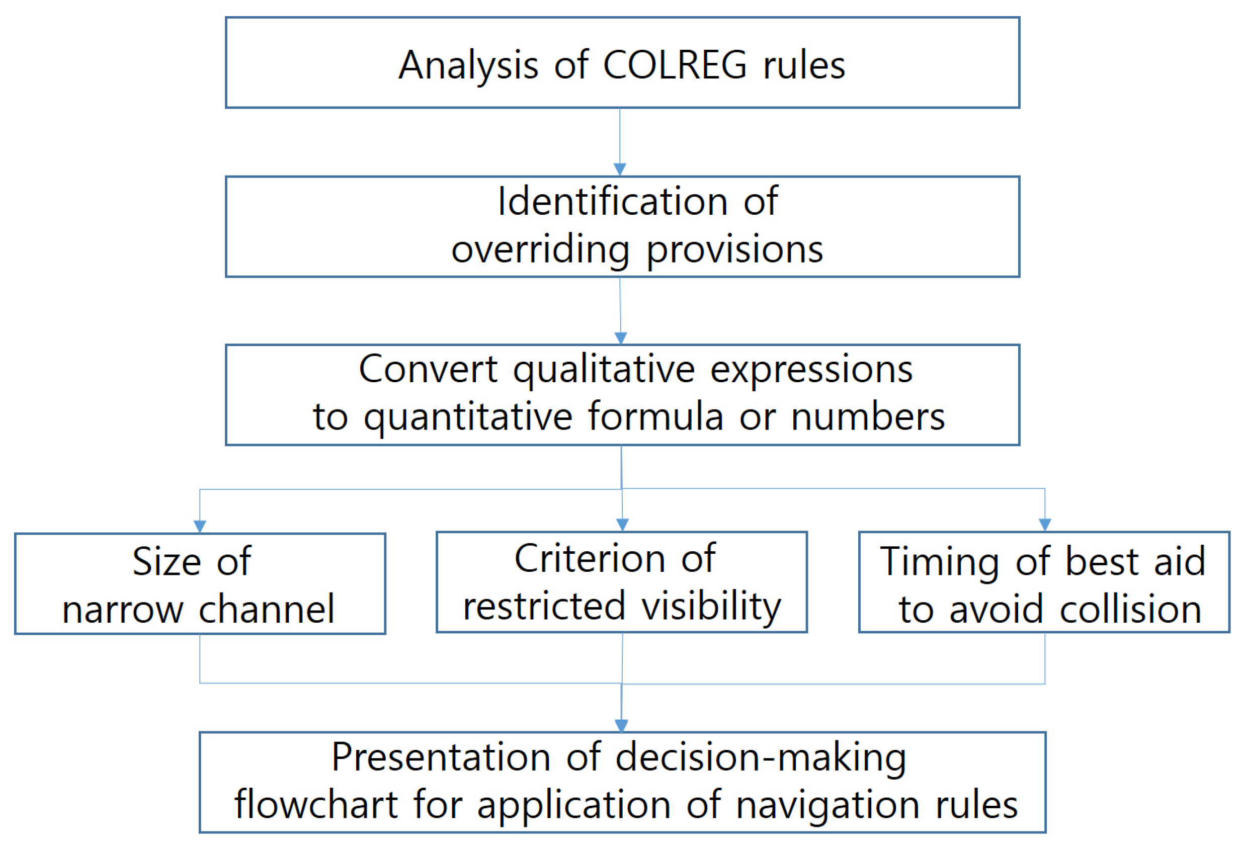
This paper carefully analyzes the navigation rules of the COLREG and develops a decision-making flowchart that is essential for determining the appropriate legal actions to avoid collisions between ships;
(2)
Numbers and formulas have enabled autonomous ships to interpret legal terms written for human navigators by the COLREG.

2. Methodology

This study proposes a legal framework for decision-making to mitigate collision risks in autonomous vessels. Legal collision avoidance action refers to actions taken by the COLREG. The goal was to establish the priority of each provision within its application. Therefore, this research method involved analyzing the COLREG rules and their history to identify the provisions that should be prioritized among various provisions.
The COLREG consists of a total of 41 rules and four annexes, as shown in Table 2. Among these, Part F is unrelated to navigation and the contents related to steering the ship are stipulated in Part B. Therefore, this paper thoroughly analyzes Part B and presents a flowchart for applying navigation rules.
COLREG Part B can be divided into at least four layers, as shown in Figure 3. Therefore, if an attempt is made to avoid a collision through engineering methods without considering the ship’s legal position, only one out of sixteen possible outcomes is legal. This is because, assuming that the possibility of choosing the correct action at each layer is 1/2, if you go through four layers, the final probability of choosing the legally correct action that satisfies the conditions of the previous layers will become 1/16. However, 1/16 is a value calculated purely based on a layer of situational judgment and does not represent the possibility that all autonomous ships currently developed or under development will adhere to legal navigation.
In addition, there may be situations where the autonomous ship’s steering, which is based on an engineering method to avoid collision, will be considered illegal and will not comply with the COLREG. In such cases, the autonomous ship may be held responsible for any maritime accidents that occur as a result.
In addition, efforts have been made to offer a quantitative interpretation, allowing autonomous ships to adhere to the provisions initially qualitatively intended for humans.
The terms “narrow channel”, “restricted visibility”, and “best aid to avoid collision” are not suitable for MASSs. So, features such as CPA (Closest Point of Approach), TCPA (Time to CPA), LOA (Length Overall), advance, and transfer were extracted and selected for quantitative interpretation of qualitative terms. For this purpose, previous studies and court judgments were thoroughly reviewed.
In terms of the areas where rules are applied, some rules apply to certain bodies of water and some rules apply to other marine areas. Specific water areas include narrow channels and Traffic Separation Scheme (TSS) areas. In ports and entrance areas within the territorial sea, there is an area where the navigation rules of the coastal state take precedence.
TSS areas are marked on the chart, but this does not indicate whether they are water areas where narrow channel navigation rules are applied. Therefore, it is necessary to establish a quantitative criterion for determining the width of a narrow channel for autonomous ships. This criterion will help determine whether an area should be subject to rules for narrow channel navigation.
In open waters, navigation rules vary depending on the visibility of other vessels. Radar may detect another vessel, but what radar detects has yet to be considered visually found. Then, the question remains whether it is considered restricted visibility if the other ship is not visible from a certain distance. Therefore, a criterion is needed for determining whether the sighting of another vessel for the first time at a certain distance is considered to be in restricted visibility. However, the COLREG has not presented this standard in numerical values. Therefore, this study presents the distance that serves as the standard for restricted visibility, considering the purpose and history of navigation rules.
When the risk of colliding with another vessel increases, it is essential to take early and decisive actions. However, it is worth noting that the specific amount of time and type of actions to be taken are not specified. Applying these rules is essential for navigators to determine the optimal time or distance to apply in each situation through learning and experience. However, implementing measures for autonomous ships becomes challenging if specific numerical values or formulas are provided for only some scenarios. In particular, if a vessel is stand-on, the navigators must take the best course of action for collision avoidance at the specific moment when the other vessel continues to approach dangerously without making any maneuvers.
Therefore, this paper provides a quantitative method that autonomous ships can adopt for situational judgment, along with a decision-making flowchart, simplifying the application of navigation rules as much as possible. It is also hoped that this will lead to further discussions of advantages and disadvantages and the presentation of alternatives.
This study was conducted for this analysis as depicted in the flowchart shown in Figure 4.

3. Analysis of Navigation Rules

3.1. History of Navigation Rules

The International Convention on the Prevention of Collisions at Sea, adopted in 1972, was prompted by growing international trade through seas in Europe since the mid-19th century. Ship collision accidents also rose as ship traffic increased in ports and along coasts because there was an increased need to establish traffic rules that applied to ships. In 1846, the British Parliament enacted the Steam Navigation Act, based on representative navigational practices compiled and outlined by Trinity House [41,42,43]. Two years later, in 1848, new regulations on lighting were added. These regulations stipulated that steam vessels should have red and green sidelights and white masthead lights.
The Convention on the Safety of Life at Sea (14 SOLAS) was adopted in 1914, following the Titanic accident in 1912. It included ship traffic rules under “Safety of Navigation”. However, 14 SOLAS was not enforced due to the outbreak of World War I. In 1972, a diplomatic conference led by the International Maritime Consultative Organization (IMCO) was held in London and adopted the International Convention on the Prevention of Collisions at Sea (COLREG 72). This convention separated the ship traffic rules from the SOLAS Convention.
COLREG 72 has been amended several times over the years, as shown in Table 3, and each provision carries a precise legal significance.
The COLREG was adopted to ensure consistent operational methods for collision avoidance between vessels. Provisions in the COLREG accurately describe specific situations and outline the corresponding obligations that must be fulfilled. However, these sentences were all written assuming that human beings would fulfill them.
In the COLREG, the term “vessel” was used as the subject of the sentence, but it was used in place of the Officer of the Watch (OOW) or any other watch keeper. In navigation rules, a vessel is required to maintain a proper lookout (COLREG Rule 5); proceed at a safe speed (COLREG Rule 6); determine if there is a risk of collision (COLREG Rule 7); and take collision avoidance action that is positive, made in ample time, and made with due regard to the observance of good seamanship (COLREG Rule 8).
The collision avoidance method of MASSs is actively being studied, taking into account the angles and vectors of encounters with approaching vessels [40]. It is believed, however, that this is a matter that should be reviewed step-by-step and considered in the final stage. Therefore, in order to apply engineering techniques to avoid collision with approaching vessels, it is necessary to review legal navigation regulations one-by-one.

3.2. Geographic Coverage of the COLREG

The COLREG is applied to all vessels on the high seas and in all waters connected to them that are navigable by seagoing vessels. So, all vessels, including autonomous vessels, must navigate on the sea and the connected navigable waters following COLREG Rule 1(a). Some provisions apply to confined water areas, such as narrow channels (COLREG Rule 9) and TSS zones (COLREG Rule 10). Water areas are designated as “ports and access routes” within the territorial waters of most coastal states. As a result, each state may have its domestic navigation regulations.

3.2.1. Narrow Channel

COLREG Rule 9(a) is one of the regulations that govern navigation in confined waters: “A vessel proceeding along the course of a narrow channel or fairway shall keep as near to the outer limit of the channel or fairway which lies on her starboard side as is safe and practicable”. Let us call this No. 1.1.

3.2.2. TSS Zones

Among confined water areas, the navigation rules applied in TSS Zones are prescribed in COLREG Rule 10(b) as follows: “(i) proceed in the appropriate traffic lane in the general direction of traffic flow for that lane; (ii) so far as practicable keep clear of a traffic separation line or separation zone; (iii) normally join or leave a traffic lane at the termination of the lane, but when joining or leaving from either side shall do so at as small an angle to the general direction of traffic flow as practicable”. Let us refer to this as No. 1.2.

3.2.3. Port Zone and the Other Waters

Most areas within port zones and access routes, including anchorages, ports, rivers, lakes, and inland waterways, fall within the territorial sea of a coastal state. As a result, the coastal state may establish specific navigation rules for these areas. This is legitimate according to COLREG Rule 1(b). Let us refer to this as No. 1.3, while the other waters are grouped as No. 1.4.

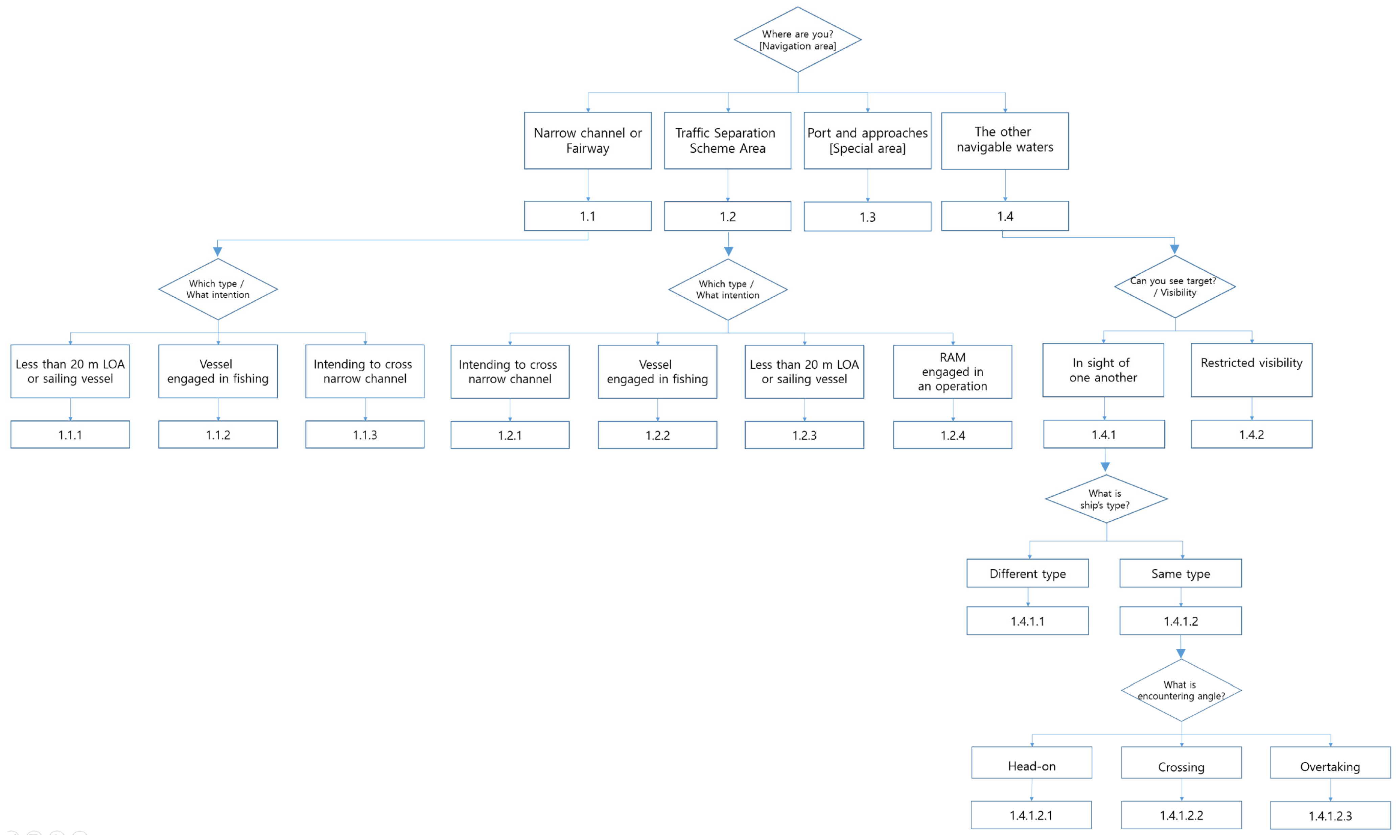
3.2.4. Flowchart of Geographical Application

If the abovementioned numbers are schematized, they can be displayed as shown in Figure 5, depending on the body of water in which the ship is located.

3.3. Application of Navigation Rules in Confined Waters

No. 1.1 applies in narrow channels, and No. 1.2 applies in TSS zones, regardless of visibility. In No. 1.3, marked in a gray color, the laws and regulations of the coastal state are applied. However, it is specified that these laws and regulations should be separate from the COLREG and have been excluded from this study.

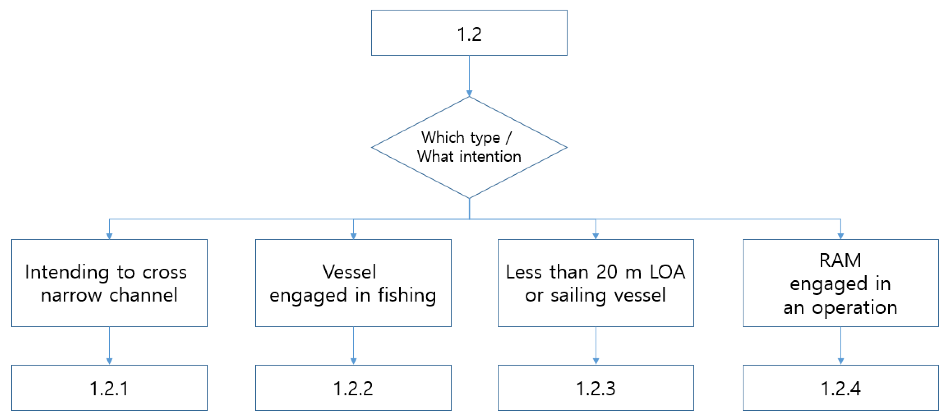
3.3.1. Navigation Rules in a Narrow Channel

In waters where No. 1.1 applies, there are separate navigation rules. These rules can be divided into No. 1.1.1, No. 1.1.2, and No. 1.1.3, as shown in Figure 6.
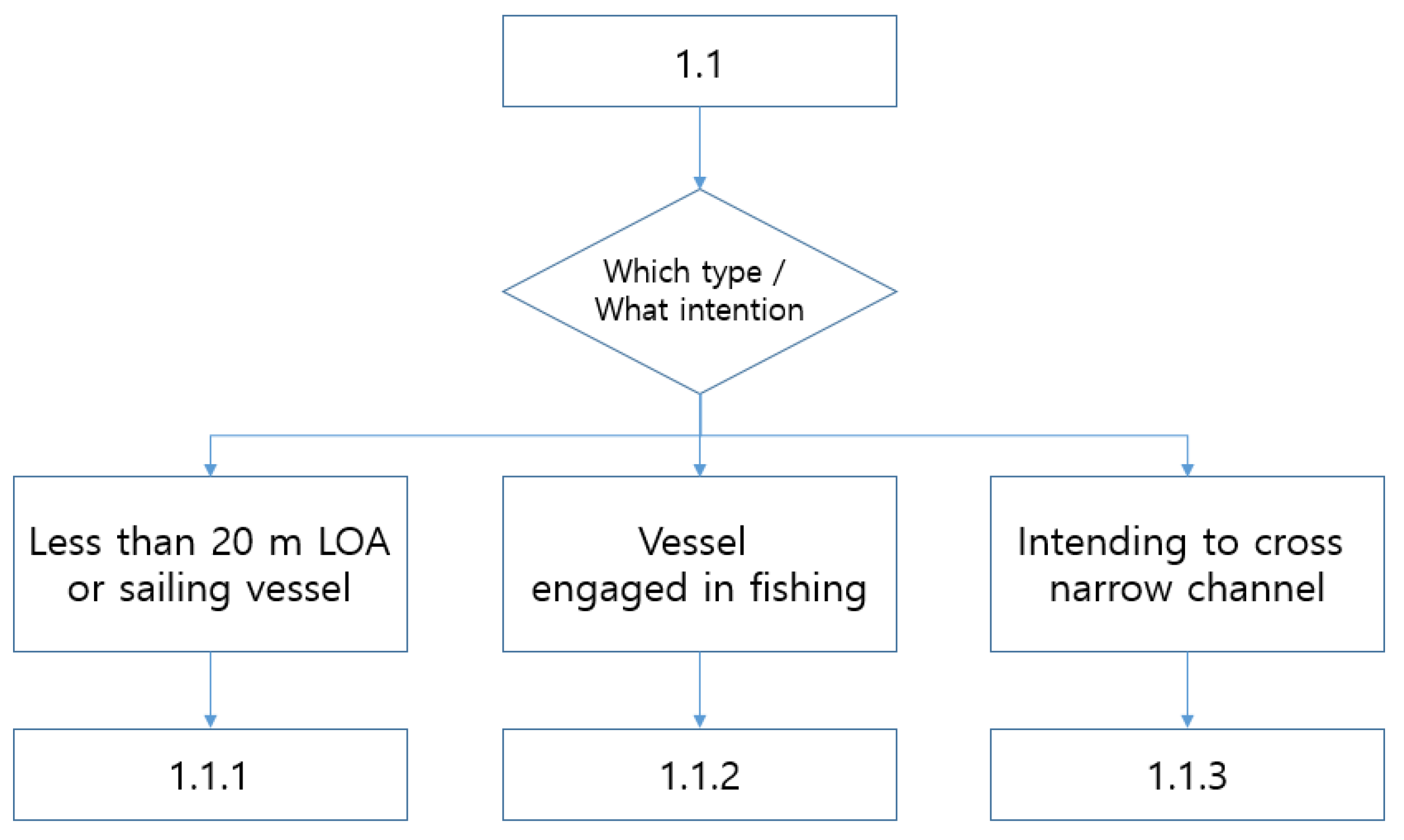
  • No. 1.1.1 is provided in COLREG Rule 9(b): “A vessel of less than 20 m in length or a sailing vessel shall not impede the passage of a vessel which can safely navigate only within a narrow channel or fairway.”
  • No. 1.1.2 is provided in COLREG Rule 9(c): “A vessel engaged in fishing shall not impede the passage of any other vessel navigating within a narrow channel or fairway.”
  • No. 1.1.3 is prescribed in COLREG Rule 9(d): “A vessel shall not cross a narrow channel or fairway if such crossing impedes the passage of a vessel which can safely navigate only within such channel or fairway. The latter vessel may use the sound signal prescribed in Rule 34(d) if in doubt as to the intention of the crossing vessel.”

3.3.2. Navigation Rules in TSS Zones

Representative navigation rules for ships using a TSS zone fall under COLREG Rule 10(b): “(i) Proceed in the appropriate traffic lane in the general direction of traffic flow for that lane; (ii) so far as practicable keep clear of a traffic separation line or separation zone; (iii) normally join or leave a traffic lane at the termination of the lane, but when joining or leaving from either side shall do so at as small an angle to the general direction of traffic flow as practicable”.
In the water area where No. 1.2 is applied, there are four types of vessels: (1) vessels of fewer than 20 m in length or sailing vessels, (2) vessels engaged in fishing, (3) vessels intending to cross the TSS, and (4) vessels restricted in their ability to maneuver (RAM) when engaged in an operation for the maintenance of safety of navigation or the laying, servicing, or picking up of a submarine. The navigation rules at this time can be classified as shown in Figure 7.
Since this study is not intended to explain specific navigation rules but rather to identify application priorities, from now on, only the COLREG provision number will be presented, and the contents of the rule will be included if necessary.

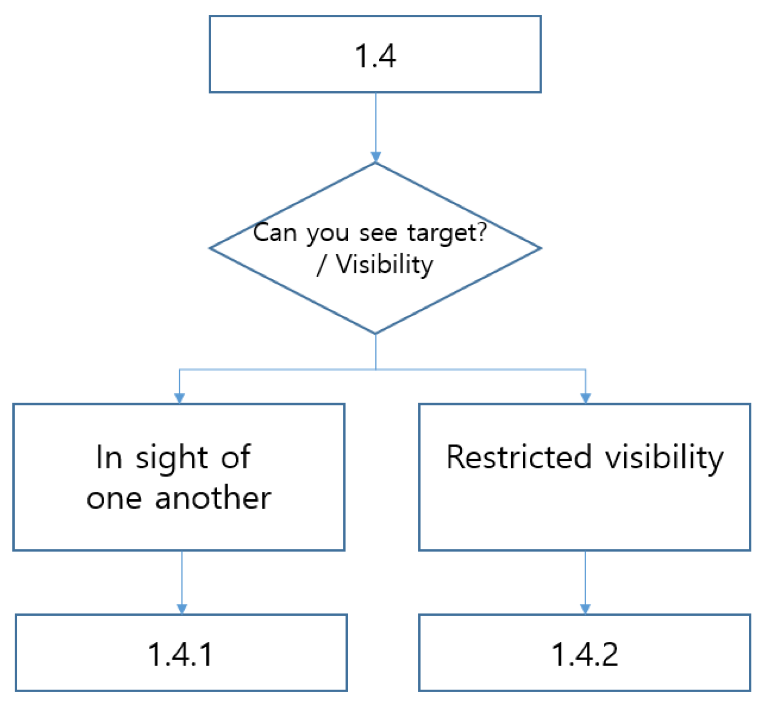
3.4. Application of Navigation Rules Based on Visibility

To classify navigation rules based on visibility, we can refer to No. 1.4.1, which applies when another ship is visible, and No. 1.4.2, which applies when visibility is restricted. Their structure is shown in Figure 8.

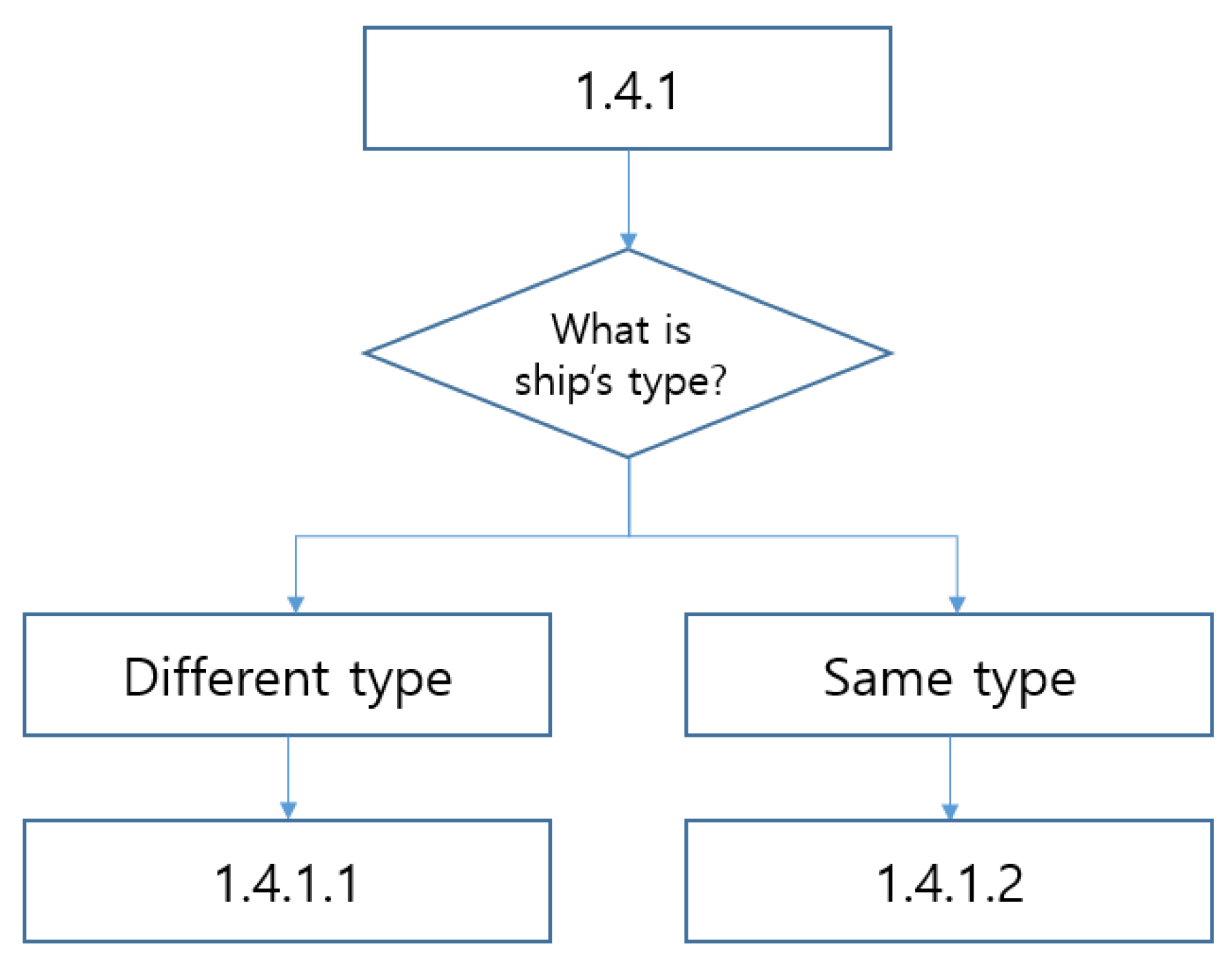
3.4.1. Navigation Rules When Vessels Are in Sight of One Another

In terms of visibility when vessels are in sight of one another, there are two categories, No. 1.4.1.1 and No. 1.4.1.2, as shown in Figure 9. This classification depends on whether the ship’s maneuvering performance will be the same or not.

Responsibilities to Give Way between Vessels

When two ships encounter, if the types of the ships are different, the ship with better maneuverability should avoid the inferior ship (COLREG Rule 18).
Ship type, however, is not classified based on the ship’s maneuvering performance, such as its speed or turning ability. The classification should be designed to allow anyone to identify the type of ship when they encounter one. The types of ships are classified as follows: vessel not under command (NUC), vessel restricted in their ability to maneuver (RAM), vessel constrained by their draft (CBD), vessel engaged in fishing, sailing vessel, power-driven vessel (PDV), seaplane, and wing-in-ground (WIG) craft.
A give-way vessel is a vessel that is required to yield to another vessel. Give-way vessels should, whenever possible, take early and substantial action to keep well clear. A stand-on vessel is a vessel that should maintain its course and speed when encountering another vessel.
When a PDV encounters a sailing ship, it should alter its course or reproduce it to avoid the sailing ship, regardless of the angle of the encounter. In this scenario, the sailing ship assumes the role of the stand-on vessel, while the PDV becomes the give-way vessel.
Vessels with priority are divided into seven categories. The order of precedence, from most privileged to least, is as follows: (1) NUC, (2) RAM, (3) CBD, (4) vessel engaged in fishing, (5) sailing vessel, (6) PDV, and (7) seaplane and WIG craft. This is shown in Table 4. The give-way ship in the leftmost column of Table 4 must avoid the paths of ships marked in blue in the right columns of the same row.

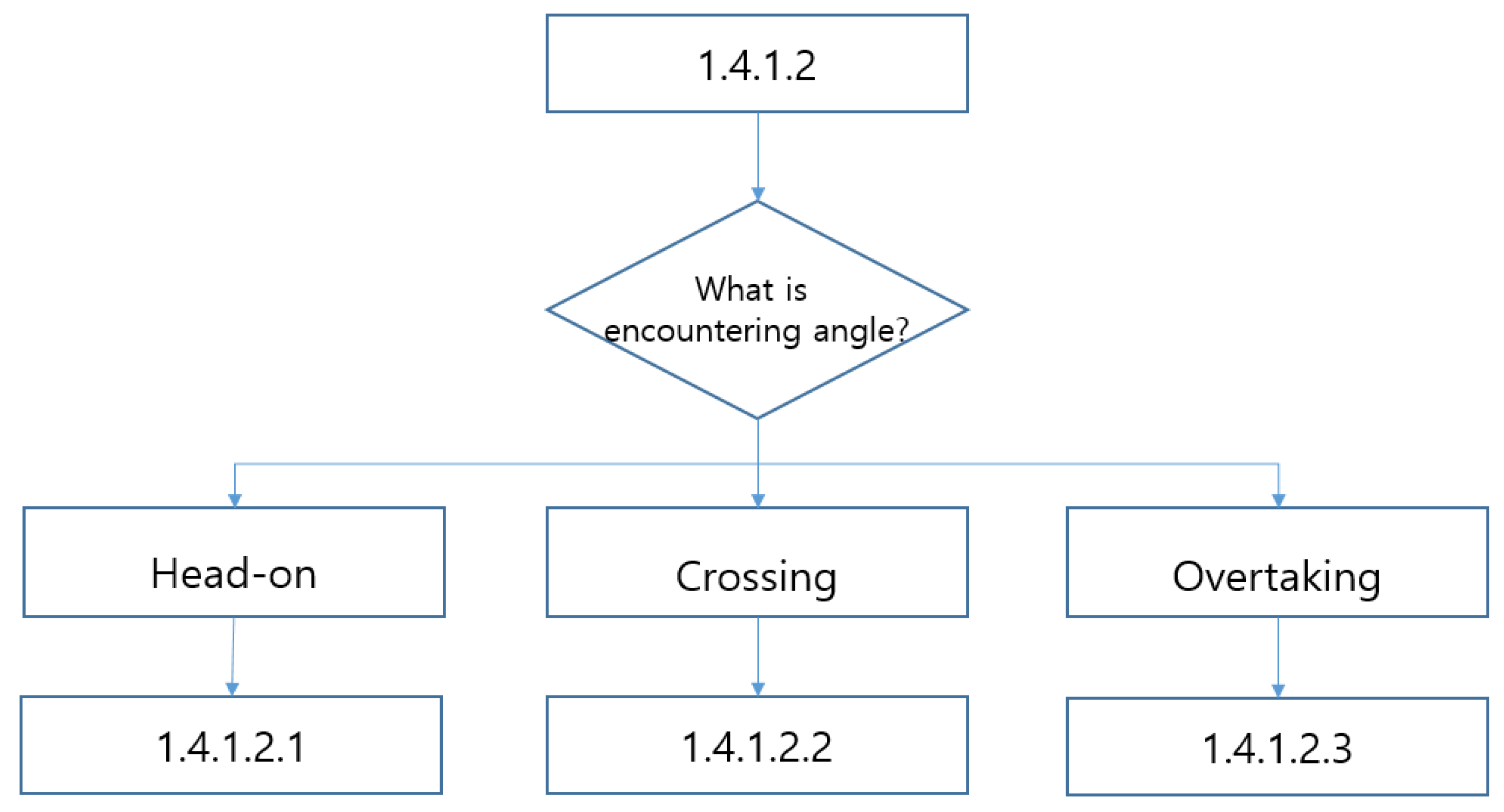
Responsibilities for Encounter Angle

The risk of collision will increase if the overtaking vessel following is faster than the preceding vessel being overtaken, as depicted on the left side of Figure 10. It will also increase in head-on situations, as shown in the middle of Figure 10, or when crossing vessels continue to proceed, as shown on the right side of Figure 10.
The rules of conduct for vessels in sight of one another (No. 1.4.1.2) apply when the other vessel is visually observable, while the rules of conduct in restricted visibility (No. 1.4.1.1) apply when the other vessel is not visible due to fog or heavy rain. Assume that the navigation rules based on the encounter angle are No. 1.4.1.2.1, No. 1.4.1.2.2, and No. 1.4.1.2.3, respectively, as depicted in Figure 11.

3.4.2. Conduct of Vessels in Restricted Visibility

The rule of restricted visibility applies to vessels not in sight of each other while navigating in or near an area with restricted visibility (COLREG Rule 19). If the vessels navigating in restricted visibility can see each other once the visibility improves, the provisions of COLEG Rule 19 will not apply. Instead, the navigation regulations that apply when vessels are in sight of one another (COLREG Rules 11 to 18) should be followed.
The relationship between stand-on and give-way vessels is formed only when they can visually observe each other without any devices. In other words, it is binding when they are in sight of one another. In conditions of restricted visibility, where all ships have equal legal status in terms of navigation priority, all ships should be considered give-way vessels. When two ships encounter each other in restricted visibility, they have to take early and positive action in accordance with the relevant regulations for preventing collisions at sea [41,51]. They should then verify that their actions are achieving the intended outcome.

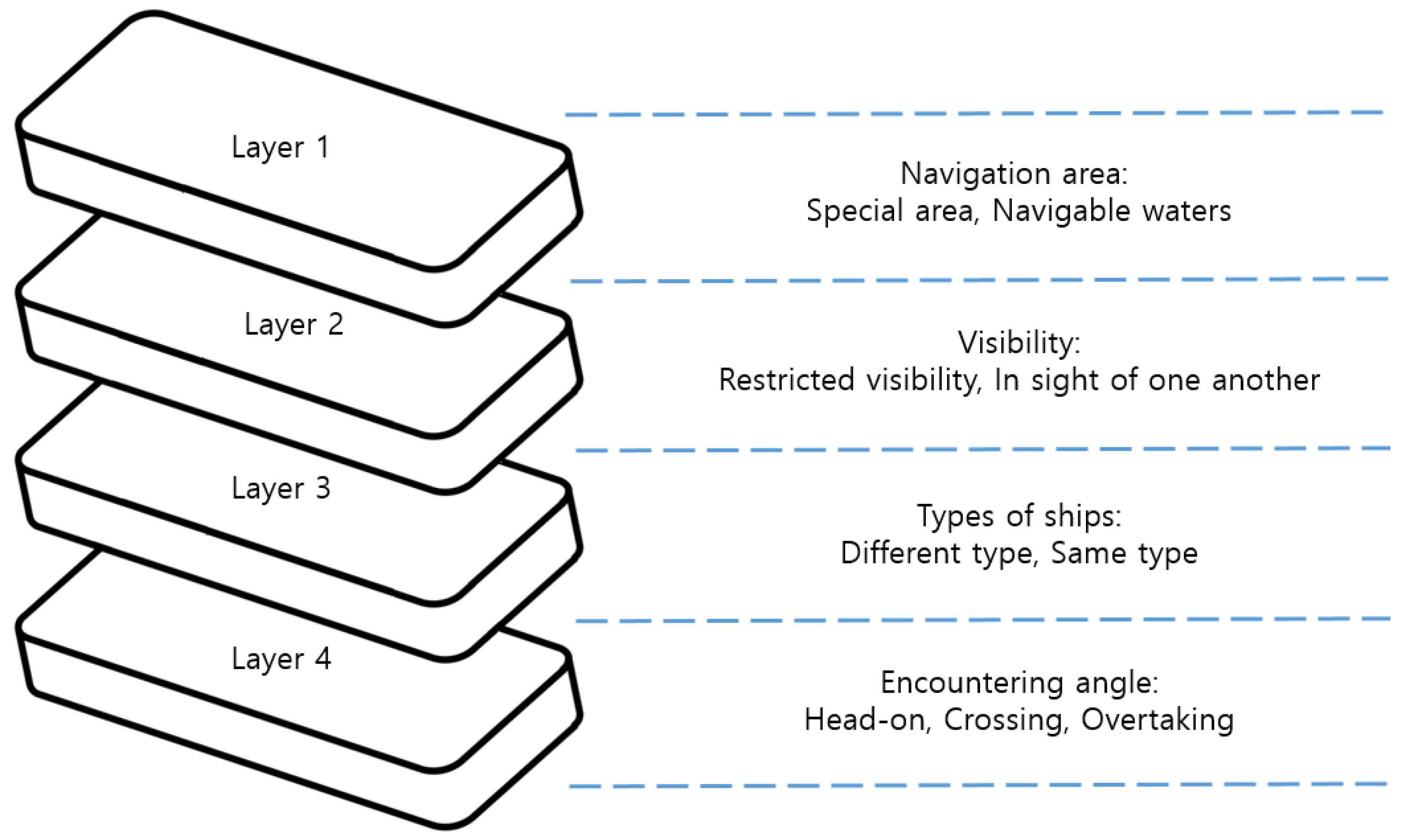
3.4.3. Summary of Tree Structure for Decision-Making

The application order of COLREG provisions has been carefully reviewed, and a decision-making tree has been developed. It has been structured as simply as possible. The flowchart for decision-making is outlined below, in Figure 12.

4. Quantification of Qualitative Expression

Provisions in the COLREG are all written with the assumption that human beings will fulfill them. The interpretation of all laws and regulations must adhere to a consistent standard, ensuring predictability. However, for MASSs to fulfill these provisions, it is necessary to quantify qualitative representations. The terms of significance related to the implementation of the COLREG include “narrow channel”, “restricted visibility”, and “best aid to avoid collision”.
In order to quantitatively calculate the parameters of “narrow channel”, “restricted visibility,” and “best aid to avoid collision”, which are of significant importance in COLREG interpretation but currently expressed non-quantitatively, a proposed quantitative interpretation is as follows.

4.1. Width of Narrow Channel

A TSS is a designated sea area established by the competent authorities of coastal states. It is easily identifiable because it will be marked on a nautical chart. However, there are various theories about narrow channels because they have no fixed width or formula.
Navigation rules in narrow channels and fairways precede the general rules applicable in the open sea because they have a special legal status [52]. However, narrow channels are more of a de facto matter than a legal one. The size of a vessel, maneuverability, draft, maritime traffic, geographical conditions, and tidal range are all significant factors that determine the width of a channel [53].
Some theories regarding the criteria for evaluating narrow channels are as follows.

4.1.1. Distance Exposed to Risk of Collision

First, this theory considers a scenario in which ships traveling in opposite directions are at risk of colliding in a channel [54,55,56,57].
This theory holds that a narrow channel should vary according to the size of the vessel and does not need to exceed approximately 3 NMs. In addition, this is generally based on comprehensive criteria, including the depth of the waterway, the width of the navigable area, the size of the passing vessel, navigational practices, and the natural conditions of the water area, such as the speed and strength of the currents, the tidal range, and the presence of sandbanks. The presence of a shallow-water area is considered a key factor in defining the concept of a narrow channel. It serves as a general criterion based on natural conditions.
This theory has the advantage of providing flexible analogical analysis for narrow channels, but it has the weakness of not guaranteeing predictability regarding legal stability. Crucially, there is a disadvantage to adopting an autonomous ship unless a specific formula or numerical value is provided.

4.1.2. Judgment Based on Legal Stability

The interpretation of all laws and regulations must adhere to a consistent standard that ensures predictability. From this perspective, a theory suggests that narrow channels should be marked with buoys and included on charts. There is a theory that a narrow channel should be judged based on the cases announced or declared by the government or competent authorities to be narrow channels [58,59,60,61].
The basis for this theory is that large ships and small ships have different turning radii. Therefore, if a narrow channel is determined based on the turning circle, it will become a narrow channel for large ships rather than small ones. This may undermine legal stability due to its lack of consistency. Even in this case, the waterway’s width is will be up to 2 NMs.
This theory has the disadvantage of a channel not being recognized as a narrow channel even though it is one in reality. This is because creating a flexible analogy for a narrow channel is tough. From the perspective of ships navigating global waters, there is a notable drawback in that this method is challenging to implement due to the absence of pre-established narrow channels maintained by all coastal states along their coastlines.

4.1.3. Audible Distance of Sound Signal

It is said that width can be determined based on the audible distance of a ship’s sound signal, as shown in Table 5. There is a belief that the width will be less than 2 NMs, as determined with the fog signal used for ships longer than 200 m. This is considered one of the methods that can be utilized for autonomous ships, but it is challenging to find instances of its application in court precedents concerning narrow channels.

4.1.4. Ship’s Safe Domain

Another theory suggests that a ship is a geographical area where close-quarters situations occur. Maritime traffic engineering, developed by Fujii and Tanaka, utilizes ship domains [62] to calculate the occupied area of a vessel sailing freely at its maximum speed in a given water area. Inspired by ship trajectory and Closest Points of Approach (CPAs), numerous studies have been conducted [63,64,65,66,67].
Meanwhile, PIANC guidelines can also be useful in determining the widths of narrow waterways. The PIANC guidelines are based on the maximum vessel’s beam when determining the width of the route [68]. It has been confirmed that, depending on regional geographic conditions and environmental differences, the minimum width of the route can range from 4 to 8 times and even up to 10 times the beam of the largest entering or leaving vessel [69]. However, in the COLREG, this was regulated based on the length of the vessel. Therefore, this review was conducted based on ship length, which is also closely related to maneuverability.
If two ships encounter each other and turn simultaneously, the turning circles of both ships and the available space of free water should be considered. This determination is made by adding the port and starboard turns and the cross turns of both ships. On the other hand, if the width is narrower than the turning circles, the channel will be considered narrow. In autonomous ships, the width of the sea area to be entered is expected to be calculated using the turning circle. This calculation can then be used to determine whether an area is a narrow channel or not. However, there is a disadvantage in terms of legal stability when it comes to a sea area that is not a narrow channel for small vessels but rather a narrow channel for large vessels. Therefore, it is necessary to have a plan to address this issue.

4.1.5. Judicial Precedent

The court precedents regarding the width of narrow channels in the United Kingdom, the United States, and Korea are as follows:
The UK has not explicitly defined a narrow waterway. However, the courts have made decisions based on the customary navigation practices of sailors in the area and the advice of the Elder Brethren (experienced seafarers). Narrow waterways do not have a specific length requirement, and in some cases, the width of a passage is considered to be approximately 2 NMs [51].
In the US, in a collision between two tows—a towing boat and a towed barge—on the lower Mississippi River, one tow was approximately 451 m (1480 ft) long and approximately 43 m (140 ft) wide, while the other tow was approximately 387 m (1269 ft) long. The area measured approximately 53 m (175 ft) in length and width. A narrow channel is typically a body of water with a depth and width sufficient for a tow of 366 m (1200 ft) or longer to pass through. US courts have applied narrow channel navigation rules to channels up to approximately 610 m (2000 ft) wide [70].
Meanwhile, the US National Transportation Safety Board (NTSB) has determined that it has needed to provide more guidance to navigators on the correct and consistent application of narrow channels for over 20 years. The NTSB has noted that navigators can only determine whether a body of water was narrow months or years after a crash, depending on a court ruling. Therefore, the NTSB has recommended that the United States Coast Guard (USCG) issue interpretive standards for narrow waterways. However, the USCG’s narrow-channel interpretation rules have yet to be publicly published.
After reviewing the precedents of the Supreme Court of the Republic of Korea, it was determined that the Geumosudo in Nam-myeon, Yeocheon-gun, Jeollanam-do, has a narrow navigable channel width of approximately 0.5 of a NM [71]. Similarly, Gao-do’s nearby channel on Geoje Island has a narrow navigable channel width of about 0.8 of a NM [72]. Lastly, Hoeng-gansudo, located on Soan-myeon in Wando-gun, Jeollanam-do, has a narrow navigable channel width of 1.5 NMs [73].

4.1.6. Discussion and Proposal

In the cases of several states, only a channel determined uniformly by the competent coastal authority can be considered a narrow waterway. A narrow channel is a sea area where collision avoidance actions, such as making significant changes in course and turning, are difficult. It is necessary to establish a standard for interpretation [74].
The specifications and conditions of vessels are also criteria for determining whether or not a narrow channel is necessary. A ship’s turning ability is the most critical criterion.
To achieve this, a sufficient length is necessary for a ship to complete a turn safely. This length should be determined by considering twice the turning radius and considering the time required for two ships to approach each other and turn simultaneously. The ship’s advance will be the minimum distance required to avoid hazards, such as obstacles in front of the ship. Therefore, this is one of the most important factors for determining a ship’s turning ability, as shown in Figure 13.
The “Interim Standards for Ship Manoeuvrability” were adopted by the IMO in 1993 concerning ship maneuverability. These standards apply to all chemical tankers, all gas carriers, and all types of ships with lengths of 100 m or more that were constructed on or after 1 July 1994 [75]. The IMO superseded the interim standards with the “Standards for Ship Manoeuvrability” in 2002 [76] and issued new explanatory notes for the standards for ship maneuverability, which replaced the previous notes adopted in 1994 [77].
In order to meet the IMO maneuverability standard, the advance should be less than 4.5 times the ship length (4.5L) and the tactical diameter should be less than five times the ship length (5L) in the turning trial conducted at the maximum steering angle of 35°.
Referring to Rules 8 and 9 of the COLREG, altering course alone may be the most effective action to avoid a close-quarters situation with sufficient sea room. Therefore, based on the maximum value of the IMO maneuverability standard, a length of 5 times the ship’s length (5L) has been considered. It has been suggested that if the width of a navigable waterway is less than 20L, it should be considered a narrow channel. This is the combined capacity of two 5L ships when turning to port and starboard and another two 5L units when both ships cross or approach head-on.
Ship’s safe domains would be a suitable approach for autonomous ships, as they utilize formulas to calculate the widths and lengths of narrow channels. However, since the application will vary depending on the size of the vessel, it may be necessary to consider a supplementary measure for determining whether a channel is narrow, based on the length of the largest vessel that passes through the area.

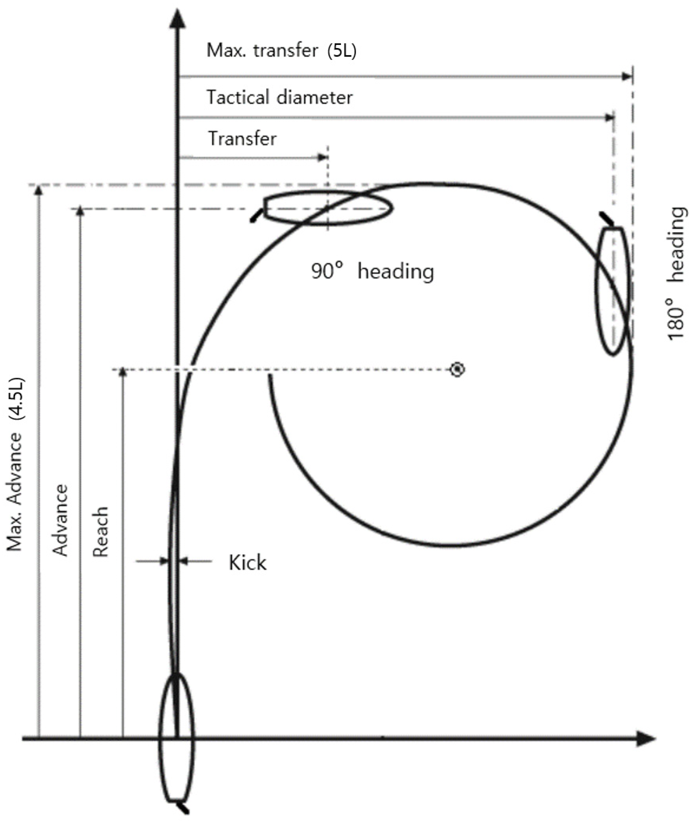
4.2. Time to Take the Best Aid to Avoid Collision

Actions to avoid collisions should be positive and made in ample time, in accordance with COLREG Rule 8. However, the COLREG has not provided specific figures regarding avoidance methods based on the risk of collision by approach distance.
In the case of a stand-on vessel, the appropriate action to be taken is to maintain the current course and speed (COLREG Rule 17(a)(i)). Any vessel that is required to give way to another vessel should, to the extent possible, take immediate and significant action to maintain a safe distance from the other vessel (COLREG Rule 8(f)(i)).
If a vessel is a give-way vessel, compliance with the COLREG can be achieved by taking early and significant action to keep well clear. In the case of a stand-on vessel, the course and speed should be maintained. However, the stand-on vessel may take action to avoid a collision by maneuvering alone as soon as it becomes apparent that the give-way vessel is not taking appropriate action (COLREG Rule 17(a)(ii)). When the stand-on vessel finds itself so close that collision cannot be avoided through the action of the give-way vessel alone, it should take the necessary action to help avoid a collision (COLREG Rule 17(b)).
A stand-on vessel cannot accurately know the details of the lookout being conducted on a give-way vessel or the ship’s maneuverability. Still, it is unsettling for a vessel to maintain its course and speed, increasing the risk of collision, until the most appropriate cooperative actions are necessary.
The longer a vessel remains in this dilemma zone, the less likely it is for the vessel to make an appropriate decision. Therefore, the stand-on vessel should decide at what distance from the give-way vessel or how long before the estimated time of collision to take action to avoid a collision solely through the maneuvering of the ship. If a CPA is calculated, the stand-on vessel should determine the distance (DCPA) or amount of time (TCPA) to allow the vessel to take appropriate action and avoid a collision by maneuvering its ship.
To make this judgment, it is necessary to determine that every vessel has unique maneuverability and refer to the IMO maneuverability standard. According to the standard, as found during the turning trial conducted at the ship’s maximum steering angle (35°), the advance should be less than 4.5 times the ship’s Length Overall (4.5L), which means that it may be possible to move up to a distance of 4.5L after initiating the turn. In addition, it is considered appropriate to turn at twice the time of 4.5L, since a situation in which the other vessel will turn in the same direction as the primary ship should be taken into consideration.
The distance for last-chance turning is nine times the vessel’s overall length (9L). The 9L TCPA method, expressed as the equation below, can be selected to determine the time distance at which to take action.
9 L   TCPA = 9 × LOA m 1852 m / Speed Knots 60 min
For instance, if the length of a vessel is 250 m and its speed is 24 knots, action should be taken 3.4 min early. Similarly, if the length is the same but the speed is 12 knots, action should be taken 6.1 min early. If a ship with a length of 200 m is traveling at a speed of 24 knots, action should be taken 2.4 min early. Similarly, for a ship of the same length traveling at 12 knots, action should be taken 4.9 min early.

4.3. Visual Length in Restricted Visibility

The first step in determining the legal relationship of collision avoidance actions between ships is to know where the primary ship is and whether the other ship is visible or invisible. To see means to perceive or observe with the eyes.
After World War II, radar began to be widely used for commercial ships [41,78]. However, what was discovered with radar still needs to be regarded in the same way as what is discovered visually. Then, the question remains whether it is considered restricted visibility if another vessel is not visible from a certain distance. However, the COLREG does not specify this standard numerically. Instead, it has aimed to establish the distance that serves as the standard for restricted visibility and the corresponding time to be applied to autonomous ships, considering the purpose and historical context of the COLREG.
COLREG rules are derived from longstanding rules of navigation that have evolved since the era of sailing ships in the 19th century. These regulations are designed to enable navigators to intuitively comprehend the movements of other vessels and take evasive actions without relying on machinery or equipment. So, although a navigator can locate another ship with radar, it does not mean the ship found with radar has been visually found. Thus, even if a ship is located using radar, it does not qualify as a visually spotted ship.
In the precedents of the Korea Maritime Safety Tribunal (KMST), restricted visibility has generally referred to cases where the area beyond the illuminated range of the ship’s sidelight is invisible. For ships of 50 m or more, the minimum luminous range of the sidelight is 3 NMs, as indicated in Table 6 (COLREG Rule 22, Annex I). Therefore, in an autonomous ship with a length of 50 m or more, if a ship is detected at a distance of 3 NMs with radar but not visible to the camera or any other visual device, it can be determined to have restricted visibility.
It is believed that using masthead lights would be safer since their minimum range is longer than that of sidelights. However, since the use of sidelights is a common practice among marine accident investigation agencies in each country, it has been adopted.

4.4. Summary of Quantitative Analysis of Qualitative Expression

The conclusions of Section 4.1, Section 4.2 and Section 4.3 can be summarized in Table 7 below.

5. Discussion

It is possible to respond to risks at an earlier stage by assuming the riskiest cases for which movement performance has been identified. Although there could be argument, maximum advance and the transfer of the turning circle were used in this study.
With respect to Section 4.1 and Section 4.2, which are based on the IMO’s Standards for Ship Maneuverability, the basic criteria have been multiplied by two to account for the presence of another ship. However, if the lengths of the two ships are different, the criteria for judgment must also differ for each ship. For such practical considerations, it is necessary to establish technical standards for related equipment and regulations for the exchange of specific information between the two ships. Afterward, it seems that a new proposal considering the length difference between ships would be feasible.
Without knowing the length and maneuverability of the other ship, the first ship will have no choice but to use its own specifications as a standard. For example, on a ship, a close-quarters situation is generally considered to begin at a distance of at least 2 NMs in any direction forward of the beam. This is because that is the typical range at which the whistle of a large vessel can be heard in still conditions [51].
The COLREG has not provided navigation instructions for every situation, nor is it feasible to describe all possible conditions. Even if that were to be carried out, there are concerns that it would actually add to confusion in interpretation. Therefore, it is necessary to study cases where attempting to adhere to navigation rules has led to collisions with small vessels, such as speedboats or leisure ships, that do not comply with navigation rules.
This may result in ethical issues. Therefore, even if some of the rules are quantifiable, relying solely on the COLREG is not sufficient. When it comes to autonomous ships, the issue of decision-making for collision avoidance, commonly known as the “Trolley problem,” needs to be addressed. However, the COLREG has only suggested that “Good seamanship” should be practiced to prevent collisions in any condition. The “Trolley problem” caused by the programmed actions of MASSs should be a research topic in the future.

6. Conclusions

When a MASS encounters a traditional manned ship, a decision-making procedure is needed to confirm the legal status between the two ships. To achieve this objective, a comprehensive analysis of COLREG Part B was conducted. The order of application of navigation rules was carefully reviewed, and a decision-making tree was developed in minimal form. This flowchart is depicted in Figure 12.
In addition, this review aimed to quantify provisions that had yet to be previously quantified, such as “narrow channels”, “best aid to avoid collision”, and “restricted visibility”.
When determining the water area to which the navigation rules for narrow channels apply, it is necessary to check whether a collision can be avoided by changing course before entering the water area. Therefore, based on the maximum value of the maneuverability standard set by the IMO, a width of 20 times the ship’s length (20L) has been proposed. The reason is that when the ship turns to one side, it requires a distance of 5 times the length of the ship (5L), which is known as the maximum transfer. In turning to port or starboard, a distance of 10 times the ship’s length is required. In addition, when two ships cross each other or encounter each other head-on, it will be necessary for each ship to give way to the other. Therefore, it is suggested that if there is no open water area that is 20 times the length of the ship (20L) in total, the water area should be considered a narrow channel.
The recommended time distance to take the best aid to avoid collision with a stand-on vessel is called “9L TCPA”, expressed as the equation below. This calculation considers the ship’s advance of the turning circle based on the IMO maneuverability standard. Considering a situation where two ships are approaching, the required distance is doubled to 9L.
9 L   TCPA = 9 × LOA m 1852 m / Speed Knots 60 min
The standard for restricted visibility recommends using particular luminous ranges for ship sidelights. In the cases of ships with lengths of 50 m or more, the luminous range of each sidelight should be 3 nautical miles. Therefore, for autonomous ships with lengths of 50 m or more, if another ship is detected with radar at a distance of 3 nautical miles but not visible with a camera or any other visual device, the navigation rules for restricted visibility should be applied.
In order to implement this proposed decision-making process for MASSs, it is necessary to introduce new equipment that is not currently standard, such as visual range measuring equipment. In this study, the descriptions of the types and performances of any additional equipment required have not been provided.
In addition, many traditional ships have a practice of communicating with approaching ships through VHF (Very High Frequency) to determine the best course of action. This agreed-upon navigation method takes priority over the COLREG. Nonetheless, little research has been conducted on the type of ship-handling information that should be provided or the most effective method of delivery for fully autonomous ships. It is believed that future research should be conducted on this topic.

Funding

This research received no external funding.

Institutional Review Board Statement

Not applicable.

Informed Consent Statement

Not applicable.

Data Availability Statement

Data was from IMO documents.

Conflicts of Interest

The author declares no conflict of interest.

Abbreviations

AIArtificial intelligence
CBDVessel constrained by her draft
COLREGConvention on the International Regulations for Preventing Collisions at Sea
CPAClosest Point of Approach
DCPADistance to CPA
ICTInformation and communications technology
IMOInternational Maritime Organization
IoTInternet of Things
KMSTKorea Maritime Safety Tribunal
LOALength Overall
MASSMaritime Autonomous Surface Ship
NMNautical mile
NTSBUnited States National Transportation Safety Board
NUCVessel not under command
OPEXOperating expenditure
PDVPower-driven vessel
R&DResearch and development
RAMVessel restricted in her ability to maneuver
SOLASInternational Convention for the Safety of Life at Sea
TCPATime to CPA
TSSTraffic Separation Scheme
USCGUnited States Coast Guard
VHFVery High Frequency
WIGWing-in-ground craft

References

  1. Burmeister, H.; Bruhn, W. Designing an autonomous collision avoidance controller respecting COLREG. In Maritime-Port Technology and Development; Taylor & Francis Group: London, UK, 2015; pp. 83–88. [Google Scholar]
  2. Marine News. First Commercial Operation of an Autonomous Vessel Begins. Available online: https://www.marinetopia.com/news/articleView.html?idxno=43549 (accessed on 25 April 2023).
  3. Yonhap News. A Large Ship without a Crew—Full-Scale Competition in the Autonomous Navigation Market. Available online: https://yonhapnewstv.co.kr/news/MYH20230712006200641 (accessed on 12 July 2023).
  4. Li, L.; Wu, D.; Huang, Y.; Yuan, Z.M. A path planning strategy unified with a COLREGS collision avoidance function based on deep reinforcement learning and artificial potential field. Appl. Ocean Res. 2021, 113, 102759. [Google Scholar] [CrossRef]
  5. Sawada, R.; Sato, K.; Majima, T. Automatic ship collision avoidance using deep reinforcement learning with LSTM in continuous action spaces. J. Mar. Sci. Technol. 2021, 26, 509–524. [Google Scholar] [CrossRef]
  6. Fan, Y.; Sun, Z.; Wang, G. A novel reinforcement learning collision avoidance algorithm for USVs based on maneuvering characteristics and COLREGs. Sensors 2022, 22, 2099. [Google Scholar] [CrossRef] [PubMed]
  7. Xu, X.; Cai, P.; Ahmed, Z.; Yellapu, V.S.; Zhang, W. Path planning and dynamic collision avoidance algorithm under COLREGs via deep reinforcement learning. Neurocomputing 2022, 468, 181–197. [Google Scholar] [CrossRef]
  8. Zhai, P.; Zhang, Y.; Shabo, W. Intelligent Ship Collision Avoidance Algorithm Based on DDQN with Prioritized Experience Replay under COLREGs. J. Mar. Sci. Eng. 2022, 10, 585. [Google Scholar] [CrossRef]
  9. Huang, Y.; Chen, L.; Negenborn, R.R.; Van Gelder, P.H.A.J.M. A ship collision avoidance system for human-machine cooperation during collision avoidance. Ocean Eng. 2020, 217, 107913. [Google Scholar] [CrossRef]
  10. Puisa, R.; McNay, J.; Montewka, J. Maritime safety: Prevention versus mitigation? Saf. Sci. 2021, 136, 105151. [Google Scholar] [CrossRef]
  11. IMO (International Maritime Organization). Outcome of the Regulatory Scoping Exercise for the Use of Maritime Autonomous Surface Ships (MASS) (MSC.1/Circ.1638); IMO: London, UK, 2021. [Google Scholar]
  12. Kim, G.; Lee, S.I. A Study on Adaptation of the ISM Code to Maritime Autonomous Surface Ships (MASS). Marit. Law Rev. 2022, 34, 359–396. [Google Scholar] [CrossRef]
  13. Issa, M.; Ilinca, A.; Ibrahim, H.; Rizk, P. Maritime Autonomous Surface Ships: Problems and Challenges Facing the Regulatory Process. Sustainability 2022, 14, 15630. [Google Scholar] [CrossRef]
  14. Choi, J.H.; Lee, S.I. Brief Study on Duty to Render Assistance in Distress at Sea of Maritime Autonomous Surface Ship. Marit. Law Rev. 2020, 32, 147–178. [Google Scholar]
  15. Lee, S.I.; Choi, J.H.; Yoo, J.H. Current Status and Legal Issues of Autonomous Ships; Dasom: Busan, Republic of Korea, 2021. [Google Scholar]
  16. Yoo, J.H.; Jung, C.S.; Lee, S.I. A Study on the Ordinary Practice of Seamen as a Controlling Principle of MASS and its Revision of Maritime Laws. Marit. Law Rev. 2019, 31, 55–88. [Google Scholar] [CrossRef]
  17. Lee, S.I.; Choi, J.H.; Yoo, J.H. Normative Issues of Maritime Autonomous Surface Ships (MASS) Pursuant to the State Jurisdictions under UNCLOS. KMI Ocean Policy Res. 2018, 33, 145–180. [Google Scholar] [CrossRef]
  18. Choi, J.H.; Yoo, J.H.; Lee, S.I. Roles and Legal Status of the Remote Operator in a Maritime Autonomous Surface Ship: Focusing on the Concept of a Crew and a Master. Marit. Law Rev. 2018, 30, 155–186. [Google Scholar] [CrossRef]
  19. Choi, J.H.; Lee, S.I. An Interpretive Consideration relating to the Ship’s Definition of the Unmanned Ship. KMI Ocean Policy Res. 2018, 33, 171–192. [Google Scholar] [CrossRef]
  20. Kim, J.; Jang, H.S. Autonomous ship technology trends and preparations. BSNAK 2019, 56, 4–7. [Google Scholar]
  21. Huang, Y.; Chen, L.; Chen, P.; Negenborn, R.R.; Van Gelder, P.H.A.J.M. Ship collision avoidance methods: State-of-the-art. Saf. Sci. 2020, 121, 451–473. [Google Scholar] [CrossRef]
  22. Krzysztof, W.; Montewka, J.; Kujala, P. Towards the assessment of potential impact of unmanned vessels on maritime transportation safety. Reliab. Eng. Syst. Saf. 2017, 165, 155–169. [Google Scholar]
  23. De Vos, J.; Hekkenberg, R.; Valdez Banda, O. The Impact of Autonomous Ships on Safety at Sea—A Statistical Analysis. Reliab. Eng. Syst. Saf. 2021, 210, 107558. [Google Scholar] [CrossRef]
  24. Bačkalov, I.; Vidić, M.; Rudaković, S. An analysis of accidents in inland navigation in context of autonomous shipping. In Proceedings of the 1st International Conference on the Stability and Safety of Ships and Ocean Vehicles, Scotland, UK, 7–11 June 2021. [Google Scholar]
  25. Bizwatch. ‘Tesla of the Sea’ When will the Autonomous Ship Launch? Available online: http://news.bizwatch.co.kr/article/industry/2022/05/06/0004 (accessed on 25 April 2023).
  26. Choi, J.Y. A Study on the Causes of Marine Accidents and Prevention of Marine Accidents in Vessels. CISSPC 2021, 25, 337–360. [Google Scholar] [CrossRef]
  27. Choi, C.W.; Noh, Y.; Shin, D.S.; Kim, H.M.; Park, H.C. Identifying Risk Factors of Marine Accidents in Coastal Area by Marine Accident Types. J. Korean Soc. Transp. 2021, 39, 540–554. [Google Scholar] [CrossRef]
  28. Kim, I.C.; Lee, H.H.; Lee, D.H. Development of a new tool for objective risk assessment and comparative analysis at coastal waters. J. Int. Marit. Saf. Environ. Aff. Shipp. 2019, 2, 58–66. [Google Scholar] [CrossRef]
  29. Kizilay, F.E.; Arslan, O.; Akyuz, E.; Kececi, T. Prediction of human error probabilitiy for officers during watchkeeping process under SLIM approach. Aust. J. Marit. Ocean Aff. 2023, 1–18. [Google Scholar] [CrossRef]
  30. Sheng, T.; Weng, J.; Shi, K.; Han, B. Analysis of human errors in maritime accidents: A Bayesian spatial multinomial logistic model. J. Transp. Saf. Secur. 2023, 1–17. [Google Scholar] [CrossRef]
  31. Ahmed, Y.A.; Hannan, M.A.; Oraby, M.Y.; Maimun, A. COLREGs compliant fuzzy-based collision avoidance system for multiple ship encounters. J. Mar. Sci. Eng. 2021, 9, 790. [Google Scholar] [CrossRef]
  32. Chen, C.; Ma, F.; Xu, X.; Chen, Y.; Wang, J. A novel ship collision avoidance awareness approach for cooperating ships using multi-agent deep reinforcement learning. J. Mar. Sci. Eng. 2021, 9, 1056. [Google Scholar] [CrossRef]
  33. Lee, H.J.; Park, D.J. SASD Modeling Using an ANFIS to Prevent the Collision of MASS in Restricted Areas. J. Mar. Sci. Eng. 2022, 10, 961. [Google Scholar] [CrossRef]
  34. Shaobo, W.; Yingjun, Z.; Lianbo, L. A collision avoidance decision-making system for autonomous ship based on modified velocity obstacle method. Ocean Eng. 2020, 215, 107910. [Google Scholar] [CrossRef]
  35. Wang, W.; Huang, L.; Liu, K.; Wu, X.; Wang, J. A COLREGs-Compliant Collision Avoidance Decision Approach Based on Deep Reinforcement Learning. J. Mar. Sci. Eng. 2022, 10, 944. [Google Scholar] [CrossRef]
  36. Zhu, Z.; Lyu, H.; Zhang, J.; Yin, Y. An Efficient Ship Automatic Collision Avoidance Method Based on Modified Artificial Potential Field. J. Mar. Sci. Eng. 2021, 10, 3. [Google Scholar] [CrossRef]
  37. Zhang, X.; Wang, C.; Chui, K.T.; Liu, R.W. A Real-Time Collision Avoidance Framework of MASS Based on B-Spline and Optimal Decoupling Control. Sensors 2021, 21, 4911. [Google Scholar] [CrossRef]
  38. Benjamin, M.R.; Curcio, J.A. COLREGS-based navigation of autonomous marine vehicles. In Proceedings of the 2004 IEEE/OES Autonomous Underwater Vehicles (IEEE Cat. No.04CH37578), Sebasco, ME, USA, 17–18 June 2004; pp. 32–39. [Google Scholar] [CrossRef]
  39. Ramos, M.A.; Utne, I.B.; Mosleh, A. Collision avoidance on maritime autonomous surface ships: Operators’ tasks and human failure events. Saf. Sci. 2019, 116, 33–44. [Google Scholar] [CrossRef]
  40. Borkowski, P.; Pietrzykowski, Z.; Magaj, J. The Algorithm of Determining an Anti-Collision Manoeuvre Trajectory Based on the Interpolation of Ship’s State Vector. Sensors 2021, 21, 5332. [Google Scholar] [CrossRef] [PubMed]
  41. Kim, I.C.; Cheong, D.Y. Regulations for Preventing Collision at Sea; Doonam: Seoul, Republic of Korea, 2020; p. 13. [Google Scholar]
  42. The History of the Rule of the Road—Sailing Vessel History. Available online: https://www.allatsea.net/the-history-of-the-rule-of-the-road/ (accessed on 17 August 2003).
  43. History of the Collision Regulations. Available online: https://www.academia.edu/14931412/History_of_the_Collision_Regulations (accessed on 17 August 2003).
  44. IMCO (International Maritime Consultative Organization). Amendments to the International Regulations For Preventing Collisions At Sea, 1972 (IMCO Res. A.464(12I)); IMO: London, UK, 1981. [Google Scholar]
  45. IMO (International Maritime Organization). Amendments to the International Regulations For Preventing Collisions At Sea, 1972 (IMO Res. A.626(15)); IMO: London, UK, 1987. [Google Scholar]
  46. IMO (International Maritime Organization). Amendments to the International Regulations For Preventing Collisions At Sea, 1972 (IMO Res. A.478(16)); IMO: London, UK, 1989. [Google Scholar]
  47. IMO (International Maritime Organization). Amendments to the International Regulations For Preventing Collisions At Sea, 1972 (IMO Res. A.736(18)); IMO: London, UK, 1993. [Google Scholar]
  48. IMO (International Maritime Organization). Amendments to the International Regulations For Preventing Collisions At Sea, 1972 (IMO Res. A.910(22)); IMO: London, UK, 2001. [Google Scholar]
  49. IMO (International Maritime Organization). Amendments to the International Regulations For Preventing Collisions At Sea, 1972 (IMO Res. A.1004(25)); IMO: London, UK, 2007. [Google Scholar]
  50. IMO (International Maritime Organization). Amendments to the International Regulations For Preventing Collisions At Sea, 1972 (IMO Res. A.1085(28)); IMO: London, UK, 2013. [Google Scholar]
  51. Cockcroft, A.N. A Guide to the Collision Avoidance Rules, 6th ed.; Elsevier: Amsterdam, The Netherlands, 2004. [Google Scholar]
  52. Lee, Y.C. Instruction of Maritime Traffic Law, 2016th ed.; Dasom: Busan, Republic of Korea, 2016; p. 248. [Google Scholar]
  53. Park, S.H.; Lee, Y.C. A Study on the Application of Navigation Rule in a Narrow Channel. J. Fish. Mar. Sci. Educ. 2018, 30, 1022–1031. [Google Scholar]
  54. Park, Y.S. Theory of Maritime Traffic Law; Hyungseol: Busan, Republic of Korea, 1998; p. 315. [Google Scholar]
  55. Yoon, J.D. COLREGs, 1972 and Related Domestic Rules in Korea, 12th ed.; Sejong: Busan, Republic of Korea, 2008; p. 102. [Google Scholar]
  56. Lee, C.H. A Study on the Definition and Navigation Rules for Narrow Channels. Res. Mar. Law 2017, 29, 42. [Google Scholar]
  57. Ji, S.W. A Study on the Status of Vessel Restricted in Her Ability to Manoeuvre in Narrow Channel. J. Navig. Port Res. 2010, 34, 833–838. [Google Scholar] [CrossRef]
  58. Kang, D.H. A Comments on the Case about Application of Navigation Rule in a Narrow Channel -Supreme Court Decision 2020.1.16. Docket No. 2019du54092 and Daejeon High Court Decision 2019.9.18. Docket No. 2019nu10342-. J. Law 2020, 44, 339–372. [Google Scholar]
  59. Kim, J.S. Narrow Channel Navigation Rule and whether a Vessel Engaged in a Towing is Restricted in her Ability to Manoeuvre or not—Focused on the Korean Supreme Court Judgment 2005.9.28 Docket No 2004chu65. JKMLA 2007, 29, 105–128. [Google Scholar]
  60. Kim, I.H. Maritime Traffic Law, 5th ed.; Samwoo: Seoul, Republic of Korea, 2018; p. 132. [Google Scholar]
  61. Lim, S.W. A Study about Navigation Application on Ship Collision Accident at Narrow Waterway. Korean Assoc. Marit. Police Sci. 2021, 11, 55–76. [Google Scholar] [CrossRef]
  62. Fujii, Y.; Tanaka, K. Traffic Capacity. J. Navig. 1971, 24, 543552. [Google Scholar] [CrossRef]
  63. Hasegawa, K. Fuzzy modelling of the behaviors and decision-making of ship navigators. In Proceedings of the 3rd International Fuzzy Systems Association (IFSA) Congress, Tokyo, Japan, 20–25 July 1989; pp. 663–666. [Google Scholar]
  64. Hasegawa, K.; Kouzuki, A. Automation Collision Avoidance System for Ships Using Fuzzy Control. J. Kansai Soc. Nav. Archit. 1987, 205, 1–10. [Google Scholar]
  65. Kijima, K.; Furukawa, Y. Design of Automatic Collision Avoidance System Using Fuzzy Inference. IFAC Proc. 2001, 34, 65–70. [Google Scholar] [CrossRef]
  66. Park, Y.S.; Park, J.S.; Shin, D.W.; Lee, M.K.; Park, S.W. Application of potential assessment of risk (PARK) model in Korea waterways. J. Int. Marit. Saf. Environ. Aff. Shipp. 2017, 1, 1–10. [Google Scholar] [CrossRef]
  67. Um, J.C.; Jang, W.J.; Cho, K.M.; Cho, I.S. A Study on the Assessment of the Marine Traffic Congestion and the Improvement of a Technical Standards. Korean Soc. Mar. Environ. Saf. 2012, 18, 416–422. [Google Scholar] [CrossRef]
  68. 68. DNV GL. Risikoanalyse av Farleder. Lengdebegrensninger ved Bruk av Farledsbevis; Kystverket Vest: Oslo, Norway, 2015. [Google Scholar]
  69. Kim, H.S. A Study on the safe width and alignment of the navigation channel. Korean Soc. Mar. Environ. Saf. 1995, 1, 9–25. [Google Scholar]
  70. Craig, H.A. Farewell’s Rules of the Nautical Road; Naval Institute Press: Annapolis, MD, USA, 2005; p. 286. [Google Scholar]
  71. Supreme Court of Korea Decision, 11 June 1993, Docket No. 1992chu55; Supreme Court of Korea: Seoul, Republic of Korea, 1993.
  72. Supreme Court of Korea Decision, 10 Dec. 1991, Docket No. 1991chu10; Supreme Court of Korea: Seoul, Republic of Korea, 1991.
  73. Supreme Court of Korea Decision, 28 Sep. 2005, Docket No. 2004chu65; Supreme Court of Korea: Seoul, Republic of Korea, 2005.
  74. Lee, Y.C. Theory of Maritime Traffic Law, 3rd ed.; Dasom: Busan, Republic of Korea, 2013; pp. 246–279.
  75. IMO (International Maritime Organization). Interim Standards for Ship Manoeuvrability (A.751 (18)); IMO: London, UK, 1993. [Google Scholar]
  76. IMO (International Maritime Organization). Standards for Ship Manoeuvrability (MSC.137 (76)); IMO: London, UK, 2002. [Google Scholar]
  77. IMO (International Maritime Organization). Appendix 3 on Stopping Ability of Very Large Ships of Interim Standards for Ship Manoeuvrability (MSC/Circ.644); IMO: London, UK, 1994. [Google Scholar]
  78. Eldridge, C. Electronic eyes for the allies: Anglo-American cooperation on radar development during World War II. Hist. Technol. 2000, 17, 1–20. [Google Scholar] [CrossRef]
Figure 1. Port-to-port steering: head-on (left) and crossing (right).
Jmse 11 01850 g001
Figure 2. Luminous angles of side lights and stern light.
Jmse 11 01850 g002
Figure 3. Layers of navigation rules.
Jmse 11 01850 g003
Figure 4. Workflow of the methodology.
Jmse 11 01850 g004
Figure 5. Navigation rules based on navigation areas.
Jmse 11 01850 g005
Figure 6. Navigation rules in a narrow channel or fairway.
Jmse 11 01850 g006
Figure 7. Navigation rules for a TSS.
Jmse 11 01850 g007
Figure 8. Navigation rules based on visibility.
Jmse 11 01850 g008
Figure 9. Navigation rules based on maneuverability.
Jmse 11 01850 g009
Figure 10. Ship-to-ship encounters: overtaking (left), head-on (middle), and crossing (right).
Jmse 11 01850 g010
Figure 11. Navigation rules based on encounter angle.
Jmse 11 01850 g011
Figure 12. Structure of COLREG for decision-making.
Jmse 11 01850 g012
Figure 13. Turning circle.
Jmse 11 01850 g013
Table 1. Degrees of automation.
DegreeLevelDescription
1Ship with automated processes and decision support for seafarers on boardSeafarers are on board to operate and control shipboard systems and functions. Some operations may be automated and at times be unsupervised but with seafarers on board ready to take control.
2Remotely controlled ship with seafarers on boardThe ship is controlled and operated from another location. Seafarers are available on board to take control and to operate the shipboard systems and functions.
3Remotely controlled ship without seafarers on boardThe ship is controlled and operated from another location. There are no seafarers on board.
4Fully autonomous shipThe operating system of the ship is able to make decisions and determine actions by itself.
Table 2. Structure of COLREG.
PartTitle (Section)Rule No.
Part AGeneral1–3
Part BSteering and Sailing Rules
  • (Section I) Conduct of vessels in any condition of visibility
  • (Section II) Conduct of vessels in sight of one another
  • (Section III) Conduct of vessels in restricted visibility
4–10
11–18
19
Part CLights and Shapes20–31
Part D Sound and Light Signals32–37
Part EExemptions38
Part FVerification of Compliance with the Provisions of the Convention39–41
Annex
  • (Annex I) Positioning and Technical Details of Lights and Shapes
  • (Annex I) Additional Signals for Fishing Vessels Fishing in Close Proximity
  • (Annex I) Technical Details of Sound Signal Appliances
  • (Annex I) Distress Signals
-
Table 3. Amendments to COLREG 72 guidelines. (Data are from IMO documents).
Revised YearAdopted/Entered into ForceAmended Rules
197220 October 1972
15 July 1977
Adoption
198119 November 1981
1 June 1983
Rule 1(c), 3(g), 3(g,v), 10(b,iii), 10(d), 10(e), 10(k), 10(1), 13(a), 22(d), 23(c), 24((a)(i), 24(c)(1), 24(d), 24(e), 24(g), 24(h), 24(1),25(b), 27(b), 27(b)(iii), 27(c) 27(d), 27(e), 27(f), 27(g), 29(a)(iii), 30(e), 30(f), 33(a), 34(b)(iii), 35(d), 36, 37, 38, 38h), Annex l/sec. 1, 2(f), 2(i)(i)„ 2(i)(ii), 2(j), 2(k), 3(b), 3(c), 5, 8, 9(a)(i), 9(a)(ii), 10(a), 10(b), 13, Annex lll/1(d), 2(a), 2(b), 3 [44]
198719 November 1987
19 November 1989
Rule 1(e), 3(h), New rule 8(f), 10(a), 10(c), Annex 1/section 2(d), 2(i)(ii), 10(a), (b), Annex IV/new para 1(o) [45]
198919 October 1989
19 April 1991
Rule 10(d)(i), 10(d)(ii) [46]
19934 November 1993
4 November 1995
Rule 26(b)(i), 26(c)(i), 26(d), Annex l/sec. 3(d), sec. 9(b), 9(b) (ii), New sec. 13, Annex ll/sec. 2(a), 2(b), 2(c), Annex IV/subpara. 1(0) [47]
200129 November 2001
29 November 2003
Rule 3(a), (m), Rule 8(a), Rule 18(f), Rule 23(c), Rule 31, Rule 33(a), Rule 35(i), Annex l/sec. 13, Annex 11 l/sec. 1-Whistles para, (a), (c), sec. 2-Bell or gong para. (b) [48]
200729 November 2007
1 December 2009
Annex IV [49]
201310 December 2013
1 January 2016
Rule 39 (new), Rule 40 (new), Rule 41 (new) [50]
Table 4. Responsibility of vessels: hierarchy of respect.
Ship
(Give-Way)
NUCRAMCBDVessel Engaged in FishingSailing VesselPDVSeaplane, WIG Craft
Seaplane, WIG Craft
PDV
Sailing vessel
Vessel engaged in fishing
CBD
RAM
NUC
Table 5. Technical details of sound signal appliances.
Length of Vessel in Meters1/3rd-Octave Band Level at 1 m in dB Referred to 2 × 10⁻⁵ N/M2Audibility Range in NMs
200 or More1432.0
75 but Less than 2001381.5
20 but Less than 751301.0
Less than 201200.5
115
111
Table 6. Minimum ranges of lights.
Light (NMs)Masthead LightSide LightsStern LightTowing LightAll-Round Light
LOA (Meter)
50 or More63333
20~5052222
12~2032222
Less than 1221222
Table 7. Numbers and formulas corresponding to qualitative terms.
Qualitative TermsProposal of FormulaNumbers
Width of Narrow ChannelFirst ship’s transfer (port 5L + starboard 5L) + approaching ship’s transfer (port 5L + starboard 5L)Less than 20L
Time to Take the Best Aid to Avoid CollisionFirst ship’s advance (4.5L) + approaching ship’s advance (4.5L) and time to CPA9L TCPA
Visual Length in Restricted VisibilityIlluminated range of side lights
  • LOA of 50 m or more: 3 NMs
  • LOA of 50~12 m: 2 NMs
  • LOA of less than 12: 1 NM
Disclaimer/Publisher’s Note: The statements, opinions and data contained in all publications are solely those of the individual author(s) and contributor(s) and not of MDPI and/or the editor(s). MDPI and/or the editor(s) disclaim responsibility for any injury to people or property resulting from any ideas, methods, instructions or products referred to in the content.

