
Integrating Different Databases to Offer a Geological Perspective of Coastal Management: A Review Case from the Northern Tuscany Littoral Cell (Italy)


Abstract
:1. Introduction
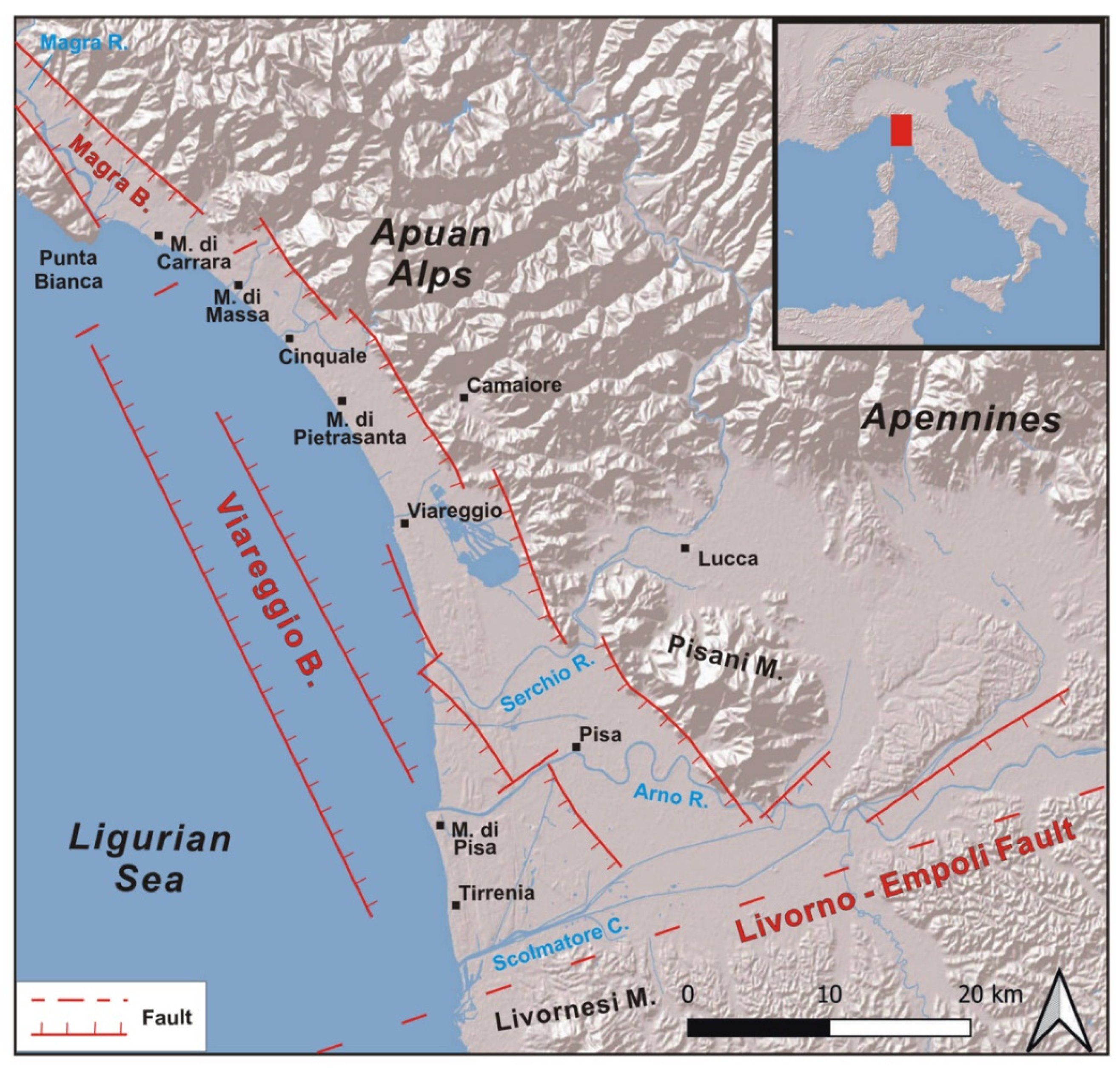
2. Physical Setting
2.1. Geological and Morphological Setting
2.2. Morphodynamic Setting
3. Dataset
3.1. Subsurface Data
3.2. Chronological and Archeological Data
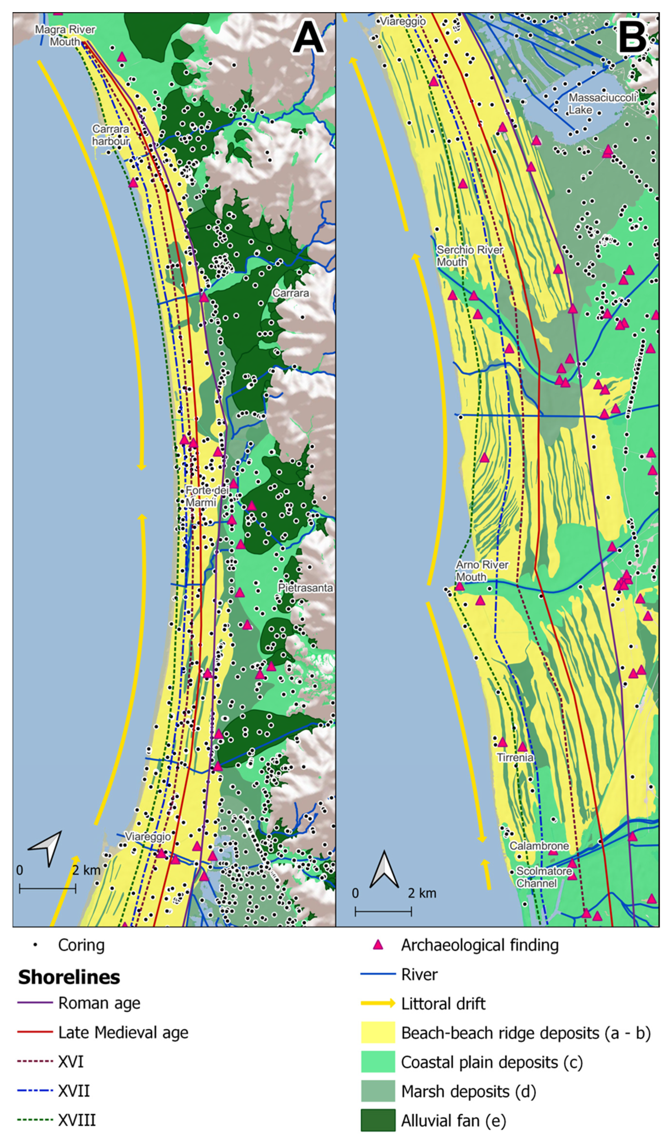
3.3. Morphological Data
4. Dataset Analysis
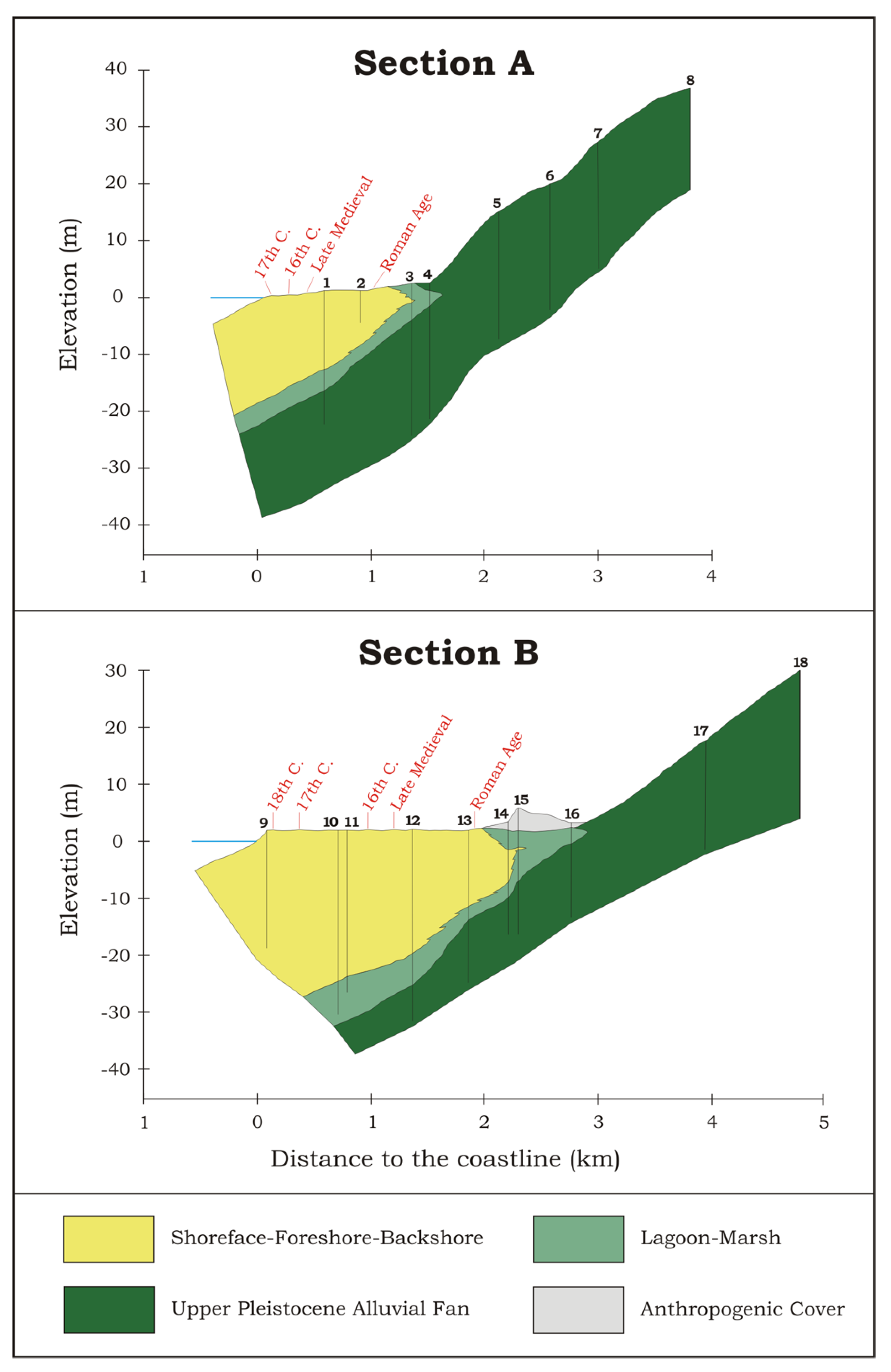
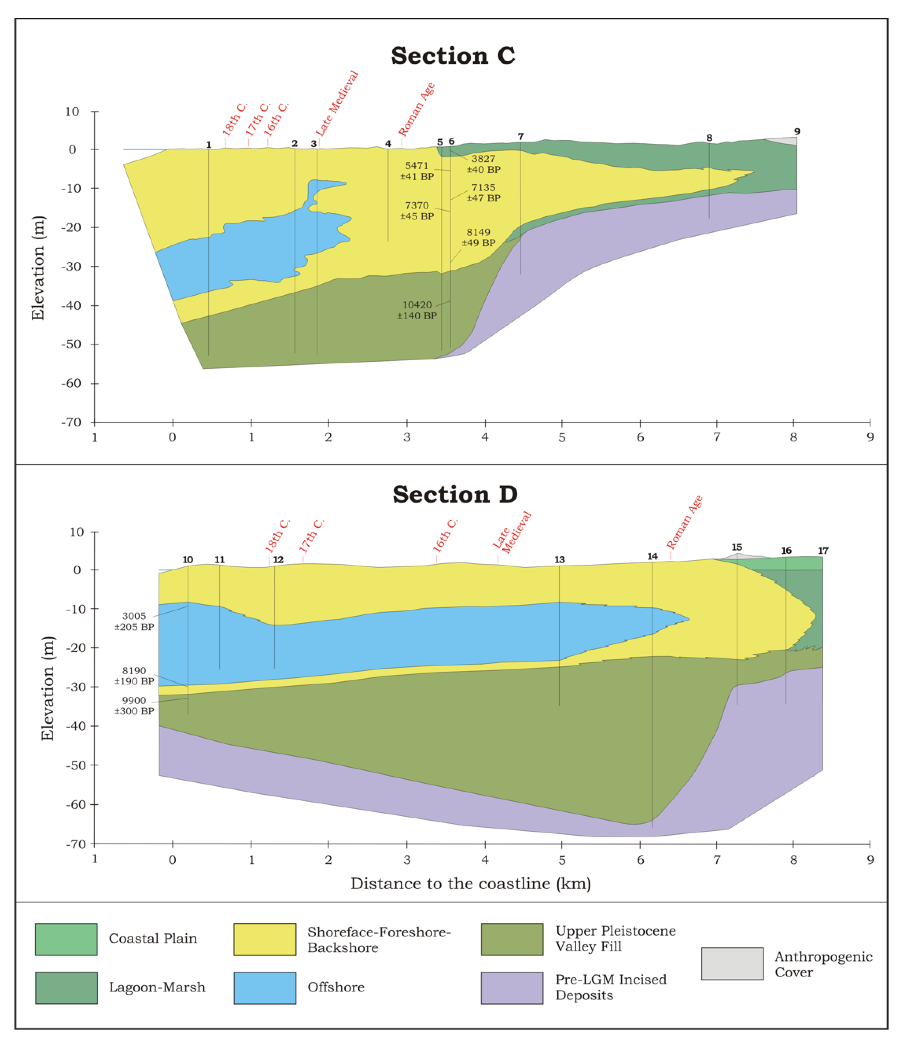
4.1. Holocene Evolution (Tens of Thousands of Years)
4.2. Historical Evolution (Tens of Centuries of Years)
4.3. Current Situation (Tens of Years)
5. Discussion
5.1. Geological and Geomorphological Legacy
5.2. Sediment Supplies and Conveyor Belts
5.3. Natural vs. Anthropogenic Driving Factors
6. Conclusions
Author Contributions
Funding
Institutional Review Board Statement
Informed Consent Statement
Data Availability Statement
Acknowledgments
Conflicts of Interest
References
- Ramieri, E.; Hartley, A.; Barbanti, A.; Duarte Santos, F.; Gomes, A.; Hilden, M.; Laihonen, P.; Marinova, N.; Santini, M. Methods for assessing coastal vulnerability to climate change. In ETC CCA Technical Paper 1/2011; ETC/CCA: Bologna, Italy, 2011; Volume 1, pp. 1–93. [Google Scholar]
- Engelbert, A.; Collet, I. Coastal regions: People living along the coastline and integration of NUTS 2010 and latest population grid. Eurostat Stat. Focus 2013, 30, 1–12. [Google Scholar]
- McMichael, C.; Dasgupta, S.; Ayeb-Karlsson, S.; Kelman, I. A review of estimating population exposure to sea-level rise and the relevance for migration. Environ. Res. Lett. 2020, 15, 123005. [Google Scholar] [CrossRef] [PubMed]
- Census Bureau Website. Available online: https://www.census.gov/topics/preparedness/about/coastal-areas.html (accessed on 7 February 2022).
- Maul, G.A.; Duedall, I.W. Demography of coastal population. In Encyclopedia of Coastal Science, 2nd ed.; Finkl, C.W., Makowski, C., Eds.; Springer: Cham, Switzerland, 2019; pp. 692–700. [Google Scholar]
- Burke, L.; Kura, Y.; Kassem, K.; Revenga, C.; Spalding, M.; McAllister, D. Coastal Ecosystems; World Resources Institute: Washington, DC, USA, 2001; p. 77. [Google Scholar]
- Frihy, O.E.; El-Sayed, M.K. Vulnerability risk assessment and adaptation to climate change induced sea level rise along the Mediterranean coast of Egypt. Mitig. Adapt. Strateg. Glob. Change 2013, 18, 1215–1237. [Google Scholar] [CrossRef]
- Aiello, A.; Canora, F.; Pasquariello, G.; Spilotro, G. Shoreline variations and coastal dynamics: A space–time data analysis of the Jonian littoral, Italy. Estuar. Coast. Shelf Sic. 2013, 129, 124–135. [Google Scholar] [CrossRef]
- Brahim, M.; Abdelfattah, A.; Sammari, C.; Aleya, L. Surface sediment dynamics along with hydrodynamics along the shores of Tunis Gulf (north-eastern Mediterranean). J. Afr. Earth Sci. 2015, 103, 30–41. [Google Scholar] [CrossRef]
- Jiménez, J.A.; Valdemoro, H.I.; Bosom, E.; Sánchez-Arcilla, A.; Nicholls, R.J. Impacts of sea-level rise-induced erosion on the Catalan coast. Reg. Environ. Change 2017, 17, 593–603. [Google Scholar] [CrossRef]
- Martínez, M.L.; Landgrave, R.; Silva, R.; Hesp, P. Shoreline dynamics and coastal dune stabilization in response to changes in infrastructure and climate. J. Coastal Res. 2019, SI92, 6–12. [Google Scholar] [CrossRef]
- Kelly, J.T.; McSweeney, S.; Shulmeister, J.; Gontz, A.M. Bimodal climate control of shoreline change influenced by Interdecadal Pacific Oscillation variability along the Cooloola Sand Mass, Queensland, Australia. Mar. Geol. 2019, 415, 105971. [Google Scholar] [CrossRef]
- Chu, L.; Oloo, F.; Sudmanns, M.; Tiede, D.; Hölbling, D.; Blaschke, T.; Teleoaca, I. Monitoring long-term shoreline dynamics and human activities in the Hangzhou Bay, China, combining daytime and nighttime EO data. Big Earth Data 2020, 4, 242–264. [Google Scholar] [CrossRef]
- Awad, M.; El-Sayed, H.M. The analysis of shoreline change dynamics and future predictions using automated spatial techniques: Case of El-Omayed on the Mediterranean coast of Egypt. Ocean Coast. Manag. 2021, 205, 105568. [Google Scholar] [CrossRef]
- Athanasiou, P.; van Dongeren, A.; Giardino, A.; Vousdoukas, M.I.; Ranasinghe, R.; Kwadijk, J. Uncertainties in projections of sandy beach erosion due to sea level rise: An analysis at the European scale. Sci. Rep. 2020, 10, 11895. [Google Scholar] [CrossRef]
- Shirzaei, M.; Freymueller, J.; Törnqvist, T.E.; Galloway, D.L.; Dura, T.; Minderhoud, P.S. Measuring, modelling and projecting coastal land subsidence. Nature Rev. Earth Environ. 2021, 2, 40–58. [Google Scholar] [CrossRef]
- Deelstra, T. Impact of Climatic Change on Coastal Cities. In Climate Change—Impact on Coastal Habitation, 1st ed.; Eisma, D., Ed.; CRC Press: Boca Raton, FL, USA, 1995; pp. 163–188. [Google Scholar]
- Cazenave, A.; Cozannet, G.L. Sea level rise and its coastal impacts. Earth’s Future 2014, 2, 15–34. [Google Scholar] [CrossRef]
- Slangen, A.B.; Meyssignac, B.; Agosta, C.; Champollion, N.; Church, J.A.; Fettweis, X.; Ligtenberg, S.R.M.; Marzeion, B.; Melet, A.; Palmer, M.D.; et al. Evaluating model simulations of twentieth-century sea level rise. Part I: Global mean sea level change. J. Climate 2017, 30, 8539–8563. [Google Scholar] [CrossRef]
- Taramelli, A.; Manzo, C.; Valentini, E.; Cornacchia, L. Coastal Subsidence: Causes, Mapping and Monitoring. In Natural Hazards—Earthquakes, Volcanoes, and Landslides, 1st ed.; Singh, R., Bartlett, D., Eds.; CRC Press: Boca Raton, FL, USA, 2018; pp. 253–290. [Google Scholar]
- Wolff, C.; Nikoletopoulos, T.; Hinkel, J.; Vafeidis, A.T. Future urban development exacerbates coastal exposure in the Mediterranean. Sci. Rep. 2020, 10, 14420. [Google Scholar] [CrossRef]
- Calabrese, L.; Luciani, P.; Perini, L. A review of impact of subsidence induced by gas exploitation on costal erosion in Emilia-Romagna, Italy. Boll. Geofis. Teor. Appl. 2021, 62, 279–300. [Google Scholar]
- Malinverno, A.; Ryan, W.B.F. Extension in the Tyrrhenian Sea and shortening in the Apennines as result of arc migration driven by sinking of the lithosphere. Tectonics 1986, 5, 227–245. [Google Scholar] [CrossRef]
- Mariani, M.; Prato, R. I bacini neogenici costieri del margine tirrenico: Approccio sismico-stratigrafico. Mem. Soc. Geol. Italy 1988, 41, 519–531. [Google Scholar]
- Antonioli, F.; Ferranti, L.; Fontana, A.; Amorosi, A.; Bondesan, A.; Braitenberg, C.; Dutton, A.; Fontolan, G.; Furlani, S.; Lambeck, K.; et al. Holocene relative sea-level changes and vertical movements along the Italian and Istrian coastlines. Quatern. Int. 2009, 206, 102–133. [Google Scholar] [CrossRef]
- Molli, G.; Manighetti, I.; Bennett, R.; Malavieille, J.; Serpelloni, E.; Storti, F.; Giampietro, T.; Bigot, A.; Pinelli, G.; Giacomelli, S.; et al. Active Fault Systems in the Inner Northwest Apennines, Italy: A Reappraisal One Century after the 1920 Mw ~6.5 Fivizzano Earthquake. Geosciences 2021, 11, 139. [Google Scholar] [CrossRef]
- Bartole, R.; Torelli, L.; Mattei, G.; Peis, D.; Brancolini, G. Assetto stratigrafico del Tirreno Settentrionale: Stato dell’arte. Studi Geol. Camerti 1991, 1, 115–140. [Google Scholar]
- Aguzzi, M.; Amorosi, A.; Colalongo, M.L.; Lucchi, M.R.; Rossi, V.; Sarti, G.; Vaiani, S.C. Late Quaternary climatic evolution of the Arno coastal plain (Western Tuscany, Italy) from subsurface data. Sediment. Geol. 2007, 202, 211–229. [Google Scholar] [CrossRef]
- Amorosi, A.; Rossi, V.; Sarti, G.; Mattei, R. Coalescent valley fills from the late Quaternary record of Tuscany (Italy). Quatern. Int. 2013, 288, 129–138. [Google Scholar] [CrossRef]
- Sarti, G.; Rossi, V.; Amorosi, A.; Bini, M.; Giacomelli, S.; Pappalardo, M.; Ribecai, C.; Ribolini, A.; Sammartino, I. Climatic signature of two mid–late Holocene fluvial incisions formed under sea-level highstand conditions (Pisa coastal plain, NW Tuscany, Italy). Palaeogeogr. Palaeocl. 2015, 424, 183–195. [Google Scholar] [CrossRef]
- Federici, P.R.; Raggi, G. Una nuova interpretazione della tettonica dei monti della Spezia. B. Soc. Geol. Italy 1975, 94, 945–960. [Google Scholar]
- Storti, F. Tectonics of the Punta Bianca promontory: Insights for the evolution of the Northern Apennines-Northern Tyrrhenian Sea basin. Tectonics 1995, 14, 832–847. [Google Scholar] [CrossRef]
- Pascucci, V. Neogene evolution of the Viareggio basin, northern Tuscany (Italy). GeoActa 2005, 4, 123–138. [Google Scholar]
- Bertoni, D.; Giacomelli, S.; Ciulli, L.; Sarti, G. Litho-sedimentological and morphodynamic characterization of the Pisa Province coastal area (northern Tuscany, Italy). J. Maps 2020, 16, 108–116. [Google Scholar] [CrossRef] [Green Version]
- Alquini, F.; Bertoni, D.; Sarti, G. Extreme erosion of a dune crest within a short timespan (January-September 2016): The recent case in the Migliarino—San Rossore—Massaciuccoli Regional Park (Tuscany, Italy). Atti Soc. Toscana Sci. Nat. Mem. Ser. A 2016, 123, 5–16. [Google Scholar]
- Mazzanti, R.; Pasquinucci, M. L’evoluzione del litorale lunense-pisano fino alla metà del XIX secolo. Boll. Soc. Geogr. Italy 1983, 12, 605–628. [Google Scholar]
- Ceccarelli Lemut, M.L.; Mazzanti, R.; Morelli, P. Il contributo delle fonti storiche alla conoscenza della geomorfologia. In La Pianura di Pisa e i Rilievi Contermini; Mazzanti, R., Ed.; Società Geografica Italiana: Roma, Italy, 1994; pp. 401–429. [Google Scholar]
- Fabiani, F. “…Stratam Antiquam que est per Paludes et Boscos…”. Viabilità Romana tra Pisa e Luni; Edizioni Plus: Pisa, Italy, 2006; p. 191. [Google Scholar]
- Piccardi, M.; Pranzini, E. Le foci del Serchio e del Fiume Morto nelle restituzioni cartografiche pre-geodetiche. Studi Costieri 2016, 23, 21–58. [Google Scholar]
- Bini, M.; Baroni, C.; Ribolini, A. Geoarchaeology as a tool for reconstructing the evolution of the Apuo-Versilian Plain (NW Italy). Geogr. Fis. Din. Quat. 2013, 36, 215–224. [Google Scholar]
- Conti, P.; Carmignani, L.; Massa, G.; Meccheri, M.; Fantozzi, P.L.; Masetti, G.; Rossetto, R. Note Illustrative della Carta Geologica d’Italia alla Scala 1:50.000 “Foglio 260—Viareggio”; Servizio Geologico d’Italia: Roma, Italy, 2012; p. 145. [Google Scholar]
- Bertoni, D.; Bini, M.; Luppichini, M.; Cipriani, L.E.; Carli, A.; Sarti, G. Anthropogenic Impact on Beach Heterogeneity within a Littoral Cell (Northern Tuscany, Italy). J. Mar. Sci. Eng. 2021, 9, 151. [Google Scholar] [CrossRef]
- Pranzini, E. Updrift river mouth migration on cuspate deltas: Two examples from the coast of Tuscany (Italy). Geomorphology 2001, 38, 125–132. [Google Scholar] [CrossRef]
- Cipriani, L.E.; Ferri, S.; Iannotta, P.; Paolieri, F.; Pranzini, E. Morfologia e dinamica dei sedimenti del litorale della Toscana settentrionale. Studi Costieri 2001, 4, 119–156. [Google Scholar]
- Cipriani, L.E.; Pranzini, E.; Vitale, G. Coastal erosion in Tuscany: Short vs. medium term evolution. In Coastal Erosion Monitoring. A Network of Regional Observatories—Results from RESMAR Project; Cipriani, L.E., Ed.; Nuova Grafica Fiorentina: Florence, Italy, 2013; pp. 135–155. [Google Scholar]
- Gandolfi, G.; Paganelli, L. Il litorale pisano-versiliese (Area campione Alto Tirreno). Composizione, provenienza e dispersione delle sabbie. Boll. Soc. Geol. Italy 1975, 94, 1273–1295. [Google Scholar]
- Garzanti, E.; Canclini, S.; Moretti Foggia, F.; Petrella, N. Unraveling magmatic and orogenic provenance in modern sand: The back-arc side of the Apennine thrust belt, Italy. J. Sediment. Res. 2002, 72, 2–17. [Google Scholar] [CrossRef]
- Bertoni, D.; Biagioni, C.; Sarti, G.; Ciccarelli, D.; Ruocco, M. The role of sediment grain-size, mineralogy, and beach morphology on plant communities of two Mediterranean coastal dune systems. Italy J. Geosci. 2014, 133, 271–281. [Google Scholar] [CrossRef]
- Sarti, G.; Bertoni, D. Monitoring backshore and foreshore gravel deposits on a mixed sand and gravel beach (Apuane-Versilia coast, Tuscany, Italy). GeoActa 2007, 6, 73–81. [Google Scholar]
- Bertoni, D.; Sarti, G. Grain size characterization of modern and ancient dunes within a dune field along the Pisan coast (Tuscany, Italy). Atti Soc. Toscana Sci. Nat. Mem. Ser. A 2011, 116, 11–16. [Google Scholar]
- Nordstrom, K.F.; Pranzini, E.; Jackson, N.L.; Coli, M. The marble beaches of Tuscany. Geogr. Rev. 2008, 98, 280–300. [Google Scholar] [CrossRef]
- Bertoni, D.; Sarti, G.; Benelli, G.; Pozzebon, A. In situ abrasion of marked pebbles on two coarse-clastic beaches (Marina di Pisa, Italy). Italy J. Geosci. 2012, 131, 205–214. [Google Scholar]
- Mappa Project Website. Available online: http://www.mappaproject.org/?lang=en (accessed on 8 February 2022).
- GEOscopio Website. Available online: https://www.regione.toscana.it/-/geoscopio (accessed on 8 February 2022).
- Provincia di Pisa Open Data Website. Available online: https://opendata.provincia.pisa.it (accessed on 8 February 2022).
- Bergamin, L.; Di Bella, L.; Frezza, V.; Devoti, S.; Nisi, M.F.; Silenzi, S.; Carboni, M.G. Late Quaternary palaeoenvironmental evolution at the Versilian coast (Tuscany, Italy): Micropalaentological proxies. In Proceedings of the Second and Third Italian Meetings on Environmental Micropaleontology, Urbino, Italy, 10–12 June 2003 and 8–9 June 2004; Special Publications 11. Coccioni, R., Marsili, A., Eds.; Grzybowski Foundation: Krakow, Poland, 2006; pp. 1–11. [Google Scholar]
- Amorosi, A.; Ricci Lucchi, M.; Rossi, V.; Sarti, G. Climate change signature of small-scale parasequences from Lateglacial–Holocene transgressive deposits of the Arno valley fill. Palaeogeogr. Palaeocl. 2009, 273, 142–152. [Google Scholar] [CrossRef]
- Carboni, M.G.; Bergamin, L.; Di Bella, L.; Esu, D.; Cerone, E.P.; Antonioli, F.; Verrubbi, V. Palaeoenvironmental reconstruction of late Quaternary foraminifera and molluscs from the ENEA borehole (Versilian plain, Tuscany, Italy). Quat. Res. 2010, 74, 265–276. [Google Scholar] [CrossRef]
- Sarti, G.; Rossi, V.; Amorosi, A. Influence of Holocene stratigraphic architecture on ground surface settlements: A case study from the City of Pisa (Tuscany, Italy). Sediment. Geol. 2012, 281, 75–87. [Google Scholar] [CrossRef]
- Rossi, V.; Amorosi, A.; Sarti, G.; Mariotti, S. Late Quaternary multiple incised valley systems: An unusually well-preserved stratigraphic record of two interglacial valley-fill successions from the Arno Plain (northern Tuscany, Italy). Sedimentology 2017, 64, 1901–1928. [Google Scholar] [CrossRef]
- Amorosi, A.; Bini, M.; Fabiani, F.; Giacomelli, S.; Pappalardo, M.; Ribecai, C.; Ribolini, A.; Rossi, V.; Sammartino, I.; Sarti, G. MAPPA cores: An interdisciplinary approach. MapPapers 2012, 4en-II, 149–200. [Google Scholar]
- Smith, C.D. Changing Environment and Roman Landscape: The ager Lunensis. In Luni and the Ager Lunensis—The Rise and Fall of a Roman Town and Its Territory; Smith, C.D., Gadd, D., Mills, N., Ward-Perkins, B., Eds.; Papers British School at Rome 1986, Volume 54; Cambridge University Press: New York, NY, USA; pp. 123–140.
- Della Rocca, B.; Mazzanti, R.; Pranzini, E. Studio geomorfologico della pianura di Pisa. Geogr. Fis. Din. Quat. 1987, 10, 56–84. [Google Scholar]
- Raggi, G.; Sansoni, G. Variazioni storiche e tendenza evolutiva della linea di riva lunense. Mem. Accad. Lunigianese Sci. 1993, 62–63, 3–43. [Google Scholar]
- Mazzanti, R.; Nencini, C. La morfologia. In La Pianura di Pisa e i Rilievi Contermini; Mazzanti, R., Ed.; Società Geografica Italiana: Roma, Italy, 1994; pp. 89–102. [Google Scholar]
- Dall’Antonia, B.; Mazzanti, R. Geomorfologia e Idrografia. In Tombolo. Territorio della Basilica di San Piero a Grado; Paglialunga, S., Ed.; Felici: Pisa, Italy, 2001; pp. 28–36. [Google Scholar]
- Bini, M.; Chelli, A.; Pappalardo, M. Caratterizzazione geomorfologica della Piana Lunense nell’ottica di una ricostruzione del paesaggio costiero in età romana. Atti Soc. Toscana Sci. Nat. Mem. Ser. A 2006, 111, 57–66. [Google Scholar]
- Sarti, G.; Bini, M.; Giacomelli, S. The growth and decline of Pisa (Tuscany, Italy) up to the Middle Ages: Correlations with landscape and geology. Alp. Mediterr. Quat. 2010, 23, 311–322. [Google Scholar]
- Amorosi, A.; Bini, M.; Giacomelli, S.; Pappalardo, M.; Ribecai, C.; Rossi, V.; Sammartino, I.; Sarti, G. Middle to late Holocene environmental evolution of the Pisa coastal plain (Tuscany, Italy) and early human settlements. Quatern. Int. 2013, 303, 93–106. [Google Scholar] [CrossRef]
- Bini, M.; Casarosa, N.; Ribolini, A. Multitemporal (1938–2004) evolution of the Pisan shoreline based on the comparison of georeferenced aerial images. Atti Soc. Toscana Sci. Nat. Mem. Ser. A 2008, 113, 1–12. [Google Scholar]
- Bini, M.; Casarosa, N.; Luppichini, M. Exploring the relationship between river discharge and coastal erosion: An integrated approach applied to the Pisa coastal plain (Italy). Remote Sens. 2021, 13, 226. [Google Scholar] [CrossRef]
- Mazzanti, R.; Paribeni, E.; Storti, S.; Vaggioli, M.A. La pianura versiliese nel contesto geomorfologico. In Etruscorum Ante Quam Ligurum: La Versilia tra VII e III Secolo a.C.; Paribeni, E., Ed.; Bandecchi & Vivaldi: Pontedera, Italy, 1990; pp. 33–43. [Google Scholar]
- Federici, P.R.; Mazzanti, R. Notes on the coastal plains of Tuscany. Mem. Soc. Geogr. Italy 1995, 53, 165–270. [Google Scholar]
- Pranzini, E. Airborne LIDAR survey applied to the analysis of the historical evolution of the Arno River delta (Italy). J. Coast. Res. 2007, 50, 400–409. [Google Scholar]
- Baroni, C.; Pieruccini, P.; Bini, M.; Coltorti, M.; Fantozzi, P.L.; Guidobaldi, G.; Nannini, D.; Ribolini, A.; Salvatore, M.C. Geomorphological and neotectonic map of the Apuan Alps (Tuscany, Italy). Geogr. Fis. Din. Quat. 2015, 38, 201–227. [Google Scholar]
- Bini, M.; Sarti, G.; Da Prato, S.; Fabiani, F.; Paribeni, M.; Baroni, C. Geoarcheological evidences of changes in the coastline progradation rate of the versilia coastal plain between Camaiore and Viareggio (Tuscany, Italy): Possible relationships with Late Holocene high-frequency transgressive regressive cycles. Il Quaternario 2009, 22, 257–266. [Google Scholar]
- Sestini, A. Un’antica ripa marina nella pianura costiera apuana. Atti Soc. Toscana Sci. Nat. Mem. Ser. A 1957, 57, 1–6. [Google Scholar]
- Federici, P.R. The Versilian transgression of the Versilia area (Tuscany, Italy) in the light of drillings and radiometric data. Mem. Soc. Geogr. Italy 1993, 49, 217–225. [Google Scholar]
- Bini, M.; Rossi, V.; Amorosi, A.; Pappalardo, M.; Sarti, G.; Noti, V.; Capitani, M.; Fabiani, F.; Gualandi, M.L. Palaeoenvironments and palaeotopography of a multilayered city during the Etruscan and Roman periods: Early interaction of fluvial processes and urban growth at Pisa (Tuscany, Italy). J. Archaeol. Sci. 2015, 59, 197–210. [Google Scholar] [CrossRef]
- Amorosi, A.; Milli, S. Late Quaternary depositional architecture of Po and Tevere river deltas (Italy) and worldwide comparison with coeval deltaic successions. Sediment. Geol. 2001, 144, 357–375. [Google Scholar] [CrossRef]
- Anthony, E.J.; Marriner, N.; Morhange, C. Human influence and the changing geomorphology of Mediterranean deltas and coasts over the last 6000 years: From progradation to destruction phase? Earth-Sci. Rev. 2014, 139, 336–361. [Google Scholar] [CrossRef]
- Anthony, E.J. Sand and gravel supply from rivers to coasts: A review from a Mediterranean perspective. Atti Soc. Toscana Sci. Nat. Mem. Ser. A 2018, 125, 13–33. [Google Scholar]
- Pratellesi, M.; Ciavola, P.; Ivaldi, R.; Anthony, E.J.; Armaroli, C. River-mouth geomorphological changes over > 130 years (1882–2014) in a small Mediterranean delta: Is the Magra delta reverting to an estuary? Mar. Geol. 2018, 403, 215–224. [Google Scholar] [CrossRef]
- Catuneanu, O. Sequence stratigraphy: Guidelines for a standard methodology. In Advances in Sequence Stratigraphy, 1st ed.; Montenari, M., Ed.; Academic Press: Cambridge, MA, USA, 2017; pp. 1–57. [Google Scholar]
- Engelhart, S.E.; Horton, B.P. Holocene sea level database for the Atlantic coast of the United States. Quat. Sci. Rev. 2012, 54, 12–25. [Google Scholar] [CrossRef]
- García-Artola, A.; Stéphan, P.; Cearreta, A.; Kopp, R.E.; Khan, N.S.; Horton, B.P. Holocene sea-level database from the Atlantic coast of Europe. Quat. Sci. Rev. 2018, 196, 177–192. [Google Scholar] [CrossRef] [Green Version]
- Vacchi, M.; Marriner, N.; Morhange, C.; Spada, G.; Fontana, A.; Rovere, A. Multiproxy assessment of Holocene relative sea-level changes in the western Mediterranean: Sea-level variability and improvements in the definition of the isostatic signal. Earth-Sci. Rev. 2016, 155, 172–197. [Google Scholar] [CrossRef] [Green Version]
- Bird, E.C. Present and future sea level: The effects of predicted global changes. In Climate Change—Impact on Coastal Habitation, 1st ed.; Eisma, D., Ed.; CRC Press: Boca Raton, FL, USA, 1995; pp. 29–56. [Google Scholar]
- Cronin, T.M. Rapid sea-level rise. Quat. Sci. Rev. 2012, 56, 11–30. [Google Scholar] [CrossRef]
- Church, J.A.; Clark, P.U.; Cazenave, A.; Gregory, J.M.; Jevrejeva, S.; Levermann, A.; Merrifield, M.A.; Milne, G.A.; Nerem, R.S.; Nunn, P.D.; et al. Sea Level Change. In Climate Change 2013: The Physical Science Basis. Contribution of Working Group I to the Fifth Assessment Report of the Intergovernmental Panel on Climate Change; Stocker, T.F., Qin, D., Plattner, G.K., Tignor, M., Allen, S.K., Boschung, J., Nauels, A., Xia, Y., Bex, V., Midgley, P.M., Eds.; Cambridge University Press: Cambridge, UK; New York, NY, USA, 2013; pp. 1137–1216. [Google Scholar]
- Vacchi, M.; Joyse, K.M.; Kopp, R.E.; Marriner, N.; Kaniewski, D.; Rovere, A. Climate pacing of millennial sea-level change variability in the central and western Mediterranean. Nat. Commun. 2021, 12, 4013. [Google Scholar] [CrossRef]
- Rossi, V.; Amorosi, A.; Sarti, G.; Potenza, M. Influence of inherited topography on the Holocene sedimentary evolution of coastal systems: An example from Arno coastal plain (Tuscany, Italy). Geomorphology 2011, 135, 117–128. [Google Scholar] [CrossRef]
- Chelli, A.; Pappalardo, M.; Bini, M.; Brückner, H.; Neri, G.; Neri, M.; Spada, G. Assessing tectonic subsidence from estimates of Holocene relative sea-level change: An example from the NW Mediterranean (Magra Plain, Italy). Holocene 2017, 27, 1988–1999. [Google Scholar] [CrossRef]
- Annuario ISPRAmbiente Website. Available online: https://annuario.isprambiente.it/sys_ind/78 (accessed on 9 February 2022).
- Cappucci, S.; Bertoni, D.; Cipriani, L.E.; Boninsegni, G.; Sarti, G. Assessment of the anthropogenic sediment budget of a littoral cell system (Northern Tuscany, Italy). Water 2020, 12, 3240. [Google Scholar] [CrossRef]
- Rinaldi, M.; Simoncini, C.; Piégay, H. Scientific design strategy for promoting sustainable sediment management: The case of the Magra River (Central-Northern Italy). River Res. Appl. 2009, 25, 607–625. [Google Scholar] [CrossRef]
- Posamentier, H.M.; Jervey, M.T.; Vail, P.R. Eustatic Controls on Clastics Deposition I–Conceptual Framework. In Sea Level Changes: An Integrated Approach; Special Publication No. 42; Wilgus, C.K., Hastings, B.S., Kendall, C.G.S.C., Posamentier, H.W., Ross, C.A., Van Wagoner, J.C., Eds.; Society of Economic Paleontologists and Mineralogists: Broken Arrow, OK, USA, 1988; pp. 109–124. [Google Scholar]
- Deng, J.; Harff, J.; Zhang, W.; Schneider, R.; Dudzińska-Nowak, J.; Giza, A.; Terefenko, P.; Furmańczyk, K. The dynamic equilibrium shore model for the reconstruction and future projection of coastal morphodynamics. In Coastline Changes of the Baltic Sea from South to East; Harff, J., Furmańczyk, K., von Storch, H., Eds.; Springer: Cham, Switzerland, 2017; pp. 87–106. [Google Scholar]
- Eichentopf, S.; Karunarathna, H.; Alsina, J.M. Morphodynamics of sandy beaches under the influence of storm sequences: Current research status and future needs. Water Sci. Eng. 2019, 12, 221–234. [Google Scholar] [CrossRef]
- Ozkan, C.; Perez, K.; Mayo, T. The impacts of wave energy conversion on coastal morphodynamics. Sci. Total Environ. 2020, 712, 136424. [Google Scholar] [CrossRef] [PubMed]
- Zăinescu, F.; Anthony, E.; Vespremeanu-Stroe, A. River Jets Versus Wave-Driven Longshore Currents at River Mouths. Front. Mar. Sci. 2021, 8, 708258. [Google Scholar] [CrossRef]
- Fitton, J.M.; Hansom, J.D.; Rennie, A.F. A national coastal erosion susceptibility model for Scotland. Ocean Coast. Manag. 2016, 132, 80–89. [Google Scholar] [CrossRef] [Green Version]
- Mentaschi, L.; Vousdoukas, M.I.; Pekel, J.F.; Voukouvalas, E.; Feyen, L. Global long-term observations of coastal erosion and accretion. Sci. Rep. 2018, 8, 12876. [Google Scholar] [CrossRef] [Green Version]
- Rangel-Buitrago, N.; Neal, W.J.; de Jonge, V.N. Risk assessment as tool for coastal erosion management. Ocean Coast. Manag. 2020, 186, 105099. [Google Scholar] [CrossRef]
- Bitencourt, V.J.B.; Dillenburg, S.R.; Manzolli, R.P.; Barboza, E.G. Control factors in the evolution of Holocene coastal barriers in Southern Brazil. Geomorphology 2020, 360, 107180. [Google Scholar] [CrossRef]
- Barboza, E.G.; Rosa, M.L.C.; Dillenburg, S.R.; Watanabe, D.S.; Esteves, T.; Martins, E.M.; Gruber, N.L. Diachronic condition between maximum transgressive and maximum eustatic sea-level in Holocene: Subsidies for coastal management. J. Coast. Res. 2018, 85, 446–450. [Google Scholar] [CrossRef]
- Amorosi, A.; Barbieri, G.; Bruno, L.; Campo, B.; Drexler, T.M.; Hong, W.; Rossi, V.; Sammartino, I.; Scarponi, D.; Vaiani, S.C.; et al. Three-fold nature of coastal progradation during the Holocene eustatic highstand, Po Plain, Italy–close correspondence of stratal character with distribution patterns. Sedimentology 2019, 66, 3029–3052. [Google Scholar] [CrossRef]
- Salomon, F.; Vittori, C.; Noirot, B.; Pleuger, E.; Rosa, C.; Mazzini, I.; Carbonel, P.; Djerbi, H.; Bellotti, P.; Goiran, J.P. Reconstruction of the Tiber Deltaic stratigraphic successions near Ostia using the PADM chart and tracking of the bedload-derived facies (Rome, Italy). Geomorphology 2020, 365, 107227. [Google Scholar] [CrossRef]
- Tvedt, T. ‘Water Systems’, Environmental History and the Deconstruction of Nature. Environ. Hist. 2010, 16, 143–166. [Google Scholar] [CrossRef]


| Year | Ownership Organization | Data Type | Reference |
|---|---|---|---|
| 1878 | IGM | Carthography | [70] |
| 1907 | IGM | Carthography | [70] |
| 1928 | IGM | Carthography | [70] |
| 1938 | IGM | Airborne Images | [70] |
| 1944 | RAF | Airborne Images | [70] |
| 1954 | Tuscany Region | Airborne Images | [70] |
| 1975 | Tuscany Region | Airborne Images | [70] |
| 1978 | Tuscany Region | Airborne Images | [70] |
| 1986 | IGM | Airborne Images | [70] |
| 1990 | IGM | Airborne Images | [70] |
| 1996 | Tuscany Region | Airborne Images | [70] |
| 2003 | Tuscany Region | Airborne Images | [70] |
| 2004 | Province of Pisa | Airborne Images | [70] |
| 2008 | Province of Pisa, University of Pisa | DGPS survey | [71] |
| 2009 | Province of Pisa, University of Pisa | DGPS survey | [71] |
| 2010 | Province of Pisa, University of Pisa | DGPS survey | [71] |
| 2011 | Province of Pisa, University of Pisa | DGPS survey | [71] |
| 2012 | Province of Pisa, University of Pisa | DGPS survey | [71] |
| 2013 | Province of Pisa, University of Pisa | DGPS survey | [71] |
| 2014 | Province of Pisa, University of Pisa | DGPS survey | [71] |
| 2015 | Province of Pisa, University of Pisa | DGPS survey | [71] |
| Roman Age | CNR, University of Pisa | Geoarchaeological data | [36] |
| Late Medieval Age | CNR, University of Pisa | Geoarchaeological data | [36] |
| XVI | CNR, University of Pisa | Geoarchaeological data | [36] |
| XVII | CNR, University of Pisa | Geoarchaeological data | [36] |
| XVIII | CNR, University of Pisa | Geoarchaeological data | [36] |
Publisher’s Note: MDPI stays neutral with regard to jurisdictional claims in published maps and institutional affiliations. |
© 2022 by the authors. Licensee MDPI, Basel, Switzerland. This article is an open access article distributed under the terms and conditions of the Creative Commons Attribution (CC BY) license (https://creativecommons.org/licenses/by/4.0/).
Share and Cite
Sarti, G.; Bertoni, D.; Bini, M. Integrating Different Databases to Offer a Geological Perspective of Coastal Management: A Review Case from the Northern Tuscany Littoral Cell (Italy). J. Mar. Sci. Eng. 2022, 10, 353. https://doi.org/10.3390/jmse10030353
Sarti G, Bertoni D, Bini M. Integrating Different Databases to Offer a Geological Perspective of Coastal Management: A Review Case from the Northern Tuscany Littoral Cell (Italy). Journal of Marine Science and Engineering. 2022; 10(3):353. https://doi.org/10.3390/jmse10030353
Chicago/Turabian StyleSarti, Giovanni, Duccio Bertoni, and Monica Bini. 2022. "Integrating Different Databases to Offer a Geological Perspective of Coastal Management: A Review Case from the Northern Tuscany Littoral Cell (Italy)" Journal of Marine Science and Engineering 10, no. 3: 353. https://doi.org/10.3390/jmse10030353
APA StyleSarti, G., Bertoni, D., & Bini, M. (2022). Integrating Different Databases to Offer a Geological Perspective of Coastal Management: A Review Case from the Northern Tuscany Littoral Cell (Italy). Journal of Marine Science and Engineering, 10(3), 353. https://doi.org/10.3390/jmse10030353