1. Introduction
Gas hydrates in the shallow layers of the deep sea may cause harm to the oceanic environment and climate environment to a certain extent, whether by artificial exploitation or by natural decomposition. More than 70% of all wells shown in the cases of global hydrocarbon exploration and development are subject to the geologic-hazard risks caused by water flow and/or gas hydrate, such as the explosion of the BP (British Petroleum) Deepwater Horizon platform in 2010 caused by gas hydrate decomposition that resulted in serious environmental pollution and economic losses [
1]. Some studies have been conducted on submarine geologic hazards in the northern continental-slope area of the South China Sea, which is rich in gas hydrate resources and where exploitation and trial production activities have become more and more frequent [
2,
3,
4]. The types, characteristics and spatial distribution of more than 20 geologic-hazard factors were studied at the Shenhu continental slope in the northern South China Sea that provide a strong reference for the safety of deep-sea engineering in the future [
5]. Various types of geologic hazards, such as pockmarks, mounds, submarine landslides, faults and fluid pipes, were identified and analyzed with 3D seismic data at the Lingshui continental slope in the northern South China Sea and three dominant control factors were indicated and proved to be important for the site selection of drilling and pipeline construction [
6]. The continental margin area of the southern South China Sea is also rich in gas hydrate resources, which are developed in a complex tectonic setting and an important geological background for hazard prevention [
7,
8]. However, the research on submarine geologic hazards in this area is relatively weak.
In general, submarine landslides are typically caused by earthquakes, volcanic eruptions, storm waves, rapid accumulation of sediment and other events or excessive slope inclinations [
9]. However, recent studies have shown that the decomposition of seabed gas hydrate that decreases slope stability is also an important cause of submarine landslides. Thick overpressure formation is also frequently developing in the continental shelf margin and slope area of the South China Sea [
10,
11,
12]. After the release of fluid in the overpressure formation, a large number of fluid leakage structures can be generated, such as gas chimneys, mounds and pockmarks [
13,
14,
15]. These fluid activities reduce the shear strength of shallow strata and easily lead to geological hazards.
The decomposition of gas hydrates can also cause shallow formation slumps and massive fluid release [
16,
17]. Hornbach et al. studied the genesis of submarine landslides along the Coast of Cape Fear in the United States and the results showed that large-scale gas hydrate decomposition may be the main factor triggering the occurrence of landslides [
17]. Taylor used seismic data to conduct a detailed analysis of hydrate-related methane trapping and leakage in the Black Sea Platform diapir area and found that gas was trapped above the diapir and below the stable region and that gas migrated upward through faults [
18]. Gas hydrate decomposition can cause vast disasters, such as large-scale submarine landslides, destruction of optical cables and offshore engineering facilities and tsunamis. At the same time, the large amount of methane released will lead to drastic climate change, ocean hypoxia [
19], global warming and other catastrophic consequences.
At present, the hazardous geological effect caused by hydrate decomposition is still insufficient and may lead to many catastrophic accidents in the process of exploration and exploitation in the future. Studying the hazardous geological effects that may occur in hydrate development areas is the premise of safe development areas in the future and provides a geological basis for formulating a safety guarantee scheme for deep-water hydrocarbon or gas-hydrate development projects.
2. Geological Background
The South China Sea is located at the conjuncture of the Eurasian, Pacific and Indo-Australian plates and has undergone the transformation of tectonic movement such as extensional, strike-slip and compressional shear, successively, with an area of approximately 3.5 × 10
6 km
2, an average water depth of 1212 m and a relatively complex tectonic evolution [
20,
21,
22]. Since the Mesozoic period, it has experienced large-scale block assembly, extrusion and strike-slip extension on the East Asian margin, as well as the rupture of the South China continental lithosphere in the Cenozoic period, the expansion of the South China Sea basin and the subduction and collision of the Pacific plate and the Indo-Australian plate. There are four different margins in the South China Sea, of which the southern part of the South China Sea is an extrusion continental margin [
23]. The southern continental-shelf slope of the South China Sea has undergone complex tectonic evolution since the Cenozoic period, with a series of basins developed, including the Zengmu, Beikang, Nanweixi and Wan’an Basins, and the formation and evolution of these basins are quite different [
24,
25].
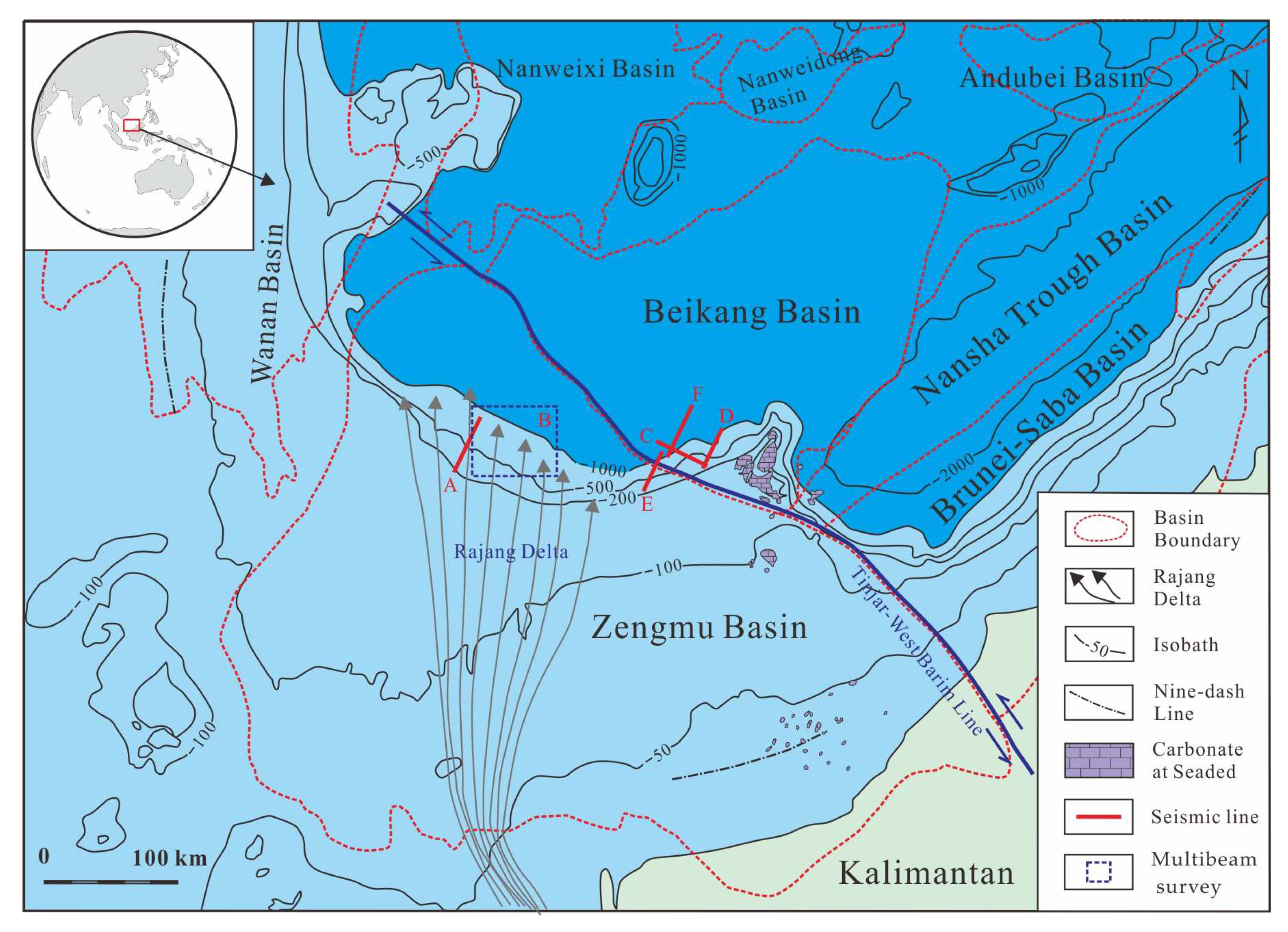
The Tinjar-West Baram line is the boundary between the Zengmu Basin and the Beikang Basin and is a NW-trending strike-slip fault, which causes the displacement and rotation of the blocks on both sides [
26,
27]. During the Miocene period, the study area of the Zengmu and Beikang basins experienced significant changes in the sedimentary environment. The early Miocene littoral–neritic environment changed to the late Miocene semi-deep deep-sea environment. During this period, the Rajang Delta developed and expanded. A large amount of terrigenous debris was injected into the northern Zengmu Basin and the southwestern Beikang Basin, forming a very thick stratum (
Figure 1) [
28]. Since the Quaternary period, the northern Zengmu Basin and the whole Beikang Basin have developed a semi-abyssal sedimentary environment with a small amount of delta front deposition. Large-scale mass transport deposits have developed in more than 50% of this area, with the main extension direction of SSE-NNW and the longest extension distance up to 130 km [
4]. The water depth of the southern-continental margin of the South China Sea varies greatly, ranging from 100 to 2000 m, and the current water-depth pattern was mainly established in the Miocene period. When the water depth is greater than 500 m in this area, the water temperature is less than 4–10 °C and varies little with season and the submarine hydrostatic pressure is greater than 5–10 MPa, which meets the conditions for the formation of gas hydrate [
29,
30].
3. Data and Methods
The data include approximately 20,000 km of seismic profiles covering almost the entire research area, obtained from several two-dimensional seismic surveys by Guangzhou Marine Geological Survey (GMGS) in the 1990s and in 2019. The spacing of most seismic profiles is 4 × 8 km, with a certain spacing of 1 × 2 km in some local areas. The data used in the present research were mainly acquired by the Marine Geology 12 using a generator/injector (GI) gun with a capacity of 2250 scf and working pressure of 2000 PSI as the seismic source, collected at 0 ms to 9.0 s, with a cable length of 3200 m and an average line spacing of 26 m to 50 m. The Marine Geology 12 is one of two two-dimensional multichannel seismic survey ships from the GMGS with 87 m long and 3574 tons of full-load displacement, equipped with an international advanced comprehensive navigation and positioning system, long-array multi-channel seismic data acquisition, single-beam echo sounder and other geophysical exploration equipment to gather the data.
High-fidelity noise attenuation technology, amplitude-compensation technology and multiple-wave suppression technology were used to improve the seismic signal-to-noise ratio and resolution by the GMGS using Focus 4.2 software between 2016 and 2020 before interpretation. The high-resolution seismic dataset was loaded into a Geoframe 4.5 (from Schlumberger, Houston, TX, USA) workstation for interactive interpretation as poststack time-migrated data (postSTM) with a zero-phase signal and frequency range from 6 to 200 Hz. Potential geological hazards caused by fluid flow, mass transport deposits and faults were identified and described on the seismic profiles. Based on the analysis of seismic reflection characteristics such as the continuity and amplitude of the reflection axis and the contact relationship with the surrounding strata, various geological hazards bodies are identified and characterized. The fluid activities associated with geological hazards, such as mud diapirs, gas chimneys and other fluid flows under geological disasters, are also described and discussed by seismic reflection characteristics. The structural characteristics of each geological hazard were determined and analyzed as part of the seismic interpretation. Geological models were established that were related to the developmental characteristics of the geological hazards.
4. Results
4.1. Submarine Mound
Submarine mounds that show as negative topographic structures formed on the seafloor by mud diapirs or mud volcanoes were found at the continental margin in the Zengmu Basin of the southern South China Sea [
8,
11,
32] (
Figure 2), with a height of 5–30 m and a diameter of 100–1.2 km. These mounds are developed independently or in patches and are more abundant in tectonically active and relatively weak shelf-slope break zones (
Figure 3). Submarine mounds are a common microtopography in hydrate development areas and are often associated with seafloor seepage. The lower part of the mound is often accompanied by fluid passages [
8]. Mud diapirs/mud volcanoes are found below mounds in the southern South China Sea. Both are caused by the plastic flow of large, thick and compacted mud/fluid into the overlying strata due to differential gravity action caused by density inversion under high temperature and high pressure. Thus, there is a special forward geological structure of curved uplift or piercing strata [
11,
32,
33]. The top of the submarine mound exhibits strong reflection characteristics, the below of which is columnar reflection. The reflection characteristics are internal chaotic reflections or blank reflections and passive folds of the formation, and strong amplitude anomalous reflections that could be the shallow gas reservoir are common around and/or at the top of the channel. The occurrence of the bottom simulating reflector (BSR) between the submarine mound and the mud diapirs/volcano indicates the existence of potential gas hydrate in this area (
Figure 2).
4.2. Pockmark
Pockmarks are negative topographic structures formed by the leakage of shallow formation fluids to the seabed [
6,
11,
13]. They are generally circular or oval, 50–200 m in diameter and extend vertically from a few meters to nearly a thousand meters, mainly in the shape of a “V” or a “U” (
Figure 4). Pockmarks tend to form in unconsolidated fine-grained sediments and are usually formed by CH
4 gas from deep fluids or upward leakages of hydrate decomposition. In the occurrence area of gas hydrate, pockmarks and pockmark aggregates of different shapes, sizes and scales can be formed on the seabed surface due to the continuous overflow of the underlying active fluid. The seismic profile shows that the pockmark terrain has obvious height difference variations and the bottom of the pockmark terrain is often connected with the fluid flow passage, which shows as columnar or faults; the seismic reflection intensity is weak and the in-phase axis shows a “drop down” shape (
Figure 4). The pockmark topography can accurately indicate the fluid flow activity in past and present seafloor sediments.
Pockmarks are often developed at the margin of the continental shelf, which is the accumulation area of abnormal submarine pressure. The formation strength in this area is relatively weak and it is easy to induce the release of overpressure fluid, which is an unfavorable engineering geological condition that must be avoided in submarine engineering construction. There are many kinds of geological hazards caused by pockmarks formed by the overflow of active fluid, which are mainly reflected in the destruction of the stability of the strata, the intensification of the greenhouse effect and the triggering of marine disasters.
4.3. Mass Transport Deposits
Mass transport deposits (MTDs), also known as submarine landslides, are hazardous geological bodies caused by gravity, usually requiring a certain terrain slope, with thick unstable loose sediments on the slope, and earthquakes or fault activities that trigger or accelerate development. Gas hydrate decomposition is also an important cause of formation landslides in gas hydrate developed areas [
3]. According to the development stage, it can be divided into slump, slip or debris flow. There are two types of landslides that can be recognized in the continental margin of the southern South China Sea: slumps and slips at the edge of the continental shelf and upper continental slope (
Figure 5) and block transport deposits in the middle and lower parts of the continental slope (
Figure 4,
Figure 6 and
Figure 7). The topography of the shelf edge and upper continental slope is steep and the MTD forms are mainly slumps and slips. The slump often rotates and slips along the shear plane of the fault or the fault plane, the internal formation is twisted and deformed and the seismic section often appears as a cluttered blank reflection (
Figure 5). The slip appears to move along the surface, showing small deformation of the inner strata and continuous reflection on the seismic profile (
Figure 6). The landslides leave rugged trenches and cliffs on the shelf slope break and the upper continental slope (
Figure 5). The MTD seismic section developed in the middle and lower parts of the continental slope shows a slip plane with high amplitude and a continuous in-phase axis, with chaotic seismic reflections inside; irregular folds or thrust-compression structures can be identified in the lower part of the sedimentary body (
Figure 6 and
Figure 7).
4.4. Submarine Collapse
Submarine collapse is typically caused by changes in the mechanical properties of the stratum due to fluid activity or hydrate decomposition at the bottom, resulting in the uneven bearing capacity of the surrounding stratum, which easily causes local subsidence deformation of the stratum (
Figure 7). When fluid diapirs or migrates upward along faults, the density of overlying and under-pressed field layers is inverted, resulting in a gravity differential effect. At the same time, tensile stress is generated at the top and dense normal faults are formed, which eventually results in the subsidence of the strata in this area.
Submarine collapse usually develops in active tectonic areas, where there are many tectonic activities (such as diapirs or faults). The decomposition of gas hydrates causes formations to collapse and the collapse may further damage the temperature and pressure environment in the gas hydrate stable zone. The further instability and collapse of the overlying sediments will not only destroy the accumulation of gas hydrates, but also cause uneven bearing capacity of the stratum, resulting in accidents such as subsidence of seabed foundations and catastrophic geological collapse, which seriously threaten the safety of marine engineering.
4.5. Fault
Fault activity will cause the sliding of blocks on both sides, triggering landslides. Meanwhile, faults, as important fluid passages, will result in collapses of the seafloor, which could cause serious damage to seafloor facilities (
Figure 4,
Figure 5 and
Figure 7). Faults as an important fluid flow passage are one of the factors that cause the above four kinds of geologic hazards. There are many faults in the continental shelf margin of the southern South China Sea and it is common for fluids to migrate through faults. In the seismic profile, along both sides of the fault, there are often “flag-like” anomalies with strong amplitude; there are also weak amplitude disorderly reflection areas caused by migration. The southern continental margin of the South China Sea is located near the Tinjar-West Baram tectonic line, which is the boundary between the Loconia Block (“Zengmu Block“) and the Nansha Block [
28,
34]. The Tinjar-West Baram tectonic line presents multistage movement, which makes the region structurally active and produces a large number of faults and fluid activities. The submarine landslide caused by the fault activity will break the temperature and pressure conditions of the gas hydrate reservoir and cause the hydrate decomposition. The active fluid flow generated by the decomposition will lead to the submarine collapse, landslide and a series of chain geologic hazards. In engineering construction, if the fault activity causes a large displacement distance between the upper and lower disks, then the exploration drill pipe or laid pipeline will be twisted or broken and the nearby structures will be damaged, resulting in significant economic losses.
5. Discussion
5.1. Formation Conditions
5.1.1. Tectonic and Sedimentary
The special tectonic and sedimentary environment is one of the main factors that lead to the formation of geologic hazards in this area. The formation and evolution of the Beikang Basin and Zengmu Basin, in which the study area is located, are both influenced by the seafloor spreading of the South China Sea and the Tinjar-West Baram tectonic line [
28,
35,
36]. After the middle Miocene period, the expansion of the South China Sea stopped and both basins entered a period of thermal subsidence. The subsidence and deposition centers were both in the study area and the maximum subsidence rate reached 300–460 m/Ma [
28,
37]. At the same time, due to the continuous development of the Rajang delta and the provision of continental margin debris during this period, the study area deposited the thickest strata in the entire South China Sea, with a thickness of more than 16,000 m [
10,
12,
36]. From the late Miocene period to the Quaternary period, large-scale volcanic activity occurred in the southern basin of the South China Sea and the Tingjia fault became active again, from dextral to left-handed with heat flow as high as >80 mW/m
2 nearby, all of which resulted in active faults and underground fluids in the continental margin of the southern South China Sea [
34,
35,
38]. During this period, the Beikang Basin was further stretched and the differential subsidence occurred, which was significantly thickened from northeast to southwest, making the study area become the center of subsidence and deposition [
28,
36]. These reasons may lead to the formation of overpressure fluids in the study area, resulting in the formation of submarine mounds, pockmarks, mass transport deposits, submarine collapses and other hazardous geological bodies.
5.1.2. Fluid Flow Activity
The primary condition for the formation of pockmarks and submarine mounds is the existence of active fluid flow, which is connected with fluid flow passages and derived from the release of overpressure fluid flow. Active fluid is a potential signal of seabed instability. Different properties of active fluid flow (i.e., different velocities and flows of fluid) may produce different overflow forms, resulting in the formation of different geological phenomena such as submarine mounds and pockmarks [
39,
40]. The overpressure fluid flow formed by the overlying thick stratum is released and migrates vertically to form a fluid pipeline. When the overpressure fluid is supplied adequately, the seabed surface will liquefy and collapse and the mass transport deposits and submarine collapse are subsequently formed. A variety of fluid flow activities, such as mud diapirs/volcanoes and gas chimneys and pipes, have been found in the southern continental margin of the South China Sea. At the same time, a large number of faults have developed in this area to connect deep and shallow strata, which can be used as passages for fluid flow. Plastic fluid or gas migrates vertically along the confined hyper-permeability zone, causing geologic hazards [
8,
36].
5.1.3. Gas Hydrate Decomposition
A lot of research for the submarine geologic hazards related to gas hydrate has been conducted and shows that gas hydrate decomposition is one of the important causes that trigger geologic hazards at many continental margins around the world [
4,
16,
17,
41]. The formation of gas hydrate is strictly controlled by temperature and pressure. A special structure and a very thick sedimentary layer are favorable conditions for its accumulation. When methane escapes from gas hydrate consolidated in seafloor sediments, it will change the physical and chemical properties of sediments (increase porosity, sediment liquefaction, and so on), greatly reduce the mechanical strength of seafloor sediments, and soften the seafloor, thus leading to large-scale geological hazards such as seafloor landslides [
42,
43,
44]. Submarine mounds formed in the gas hydrate development area on the southern margin of the South China Sea, where a string of bubbles and porridge-like sediments in the core from site CL37A presented, probably due to the decomposition of gas hydrate [
8]. At the same time, the occurrence of geological disasters breaks the temperature and pressure conditions of gas hydrate reservoirs and further causes gas hydrate decomposition [
45,
46,
47].
The geophysical and geothermal properties of gas hydrate-bearing sediment systems are probably controlled by the thermal state, saturation and pore-scale distribution of the co-existing phases that may be susceptible to external natural and/or anthropogenic factors, resulting in the instability and decomposition of gas hydrate [
48]. The natural factors may include geological hazards, fluid activities, volcanic activities and earthquakes and the anthropogenic factors mainly include undersea engineering construction, hydrocarbon drilling and gas hydrate recovery testing conducted by humans [
1,
4,
5]. The active fluid generated by decomposition will lead to a series of chain geological hazards such as stratum collapses and landslides, which are also characterized by universality, complexity and disaster causation. Ultimately it could cause harm to engineering facilities such as submarine pipelines and drilling platform pile drivers, which may also lead to major blowout accidents and seriously threaten the safety of construction workers.
5.2. Geological Model
Based on the above geological hazard identification through seismic interpretation and formation-condition analysis, a geological hazard model is established in the southern continental margin of the South China Sea. There are five major geological hazard bodies in the study area, including submarine mounds, pockmarks, mass transport deposits, submarine collapses and faults (
Figure 8).
These geological hazards are mainly developed near the shelf-slope break belt and are genetically related to the activities of fluid flow and faults in this area. Columnar fluid flow activities, such as mud diapirs, mud volcanoes and gas chimneys are found below the submarine mound and pockmark, which may be formed by deep fluid or CH
4 gas generated by an upward leakage of hydrate decomposition (
Figure 8a).
Mass transport deposits (MTDs) are mainly formed due to gravity, accompanied by faults, primarily slumps and slips. Slumps mostly occur in the continental shelf edge and upper-continental slope area; slips mainly occur in the middle and lower parts of the continental slope with relatively flat terrain (
Figure 8b,c). There are obvious slip planes in the lower part and the stratum has certain deformation and compression characteristics. Submarine collapse is accompanied by normal fault development and is also associated with underlying fluid activity. In general, in the southern-continental margin of the South China Sea, fluid activity and the decomposition of gas hydrates have caused changes in the mechanical strength of the seabed strata, resulting in uplift, collapse or slump developing in various types of geological hazards.
5.3. Impact on Exploration and Development
The stability of submarine hazard geological bodies also has a significant influence on the safety of marine engineering, especially for submarine pipelines such as optical cables and oil and gas pipelines on the seabed surface [
1,
5,
6]. Submarine mounds and pockmarks represent highly plastic geological bodies and high-stress action areas [
10,
11]. Due to the difference with surrounding rock, an uneven bearing capacity is prone to accidents, especially when it is affected by an external force or earthquake, which will cause damage to offshore drilling operations, therefore it should be avoided as much as possible. The characteristics and distribution rules of submarine geologic hazards are very important to the site selection of submarine engineering construction and help to avoid or reduce the damage degree.
5.4. Suggestions for Further Study
The relationship between the causes of submarine geological hazards and gas hydrates is complicated [
6,
49]. Many factors often act together and restrict each other, and the formation and decomposition of gas hydrates show a dynamic equilibrium relationship, which may be one of the important directions of future research. On one hand, submarine geological disasters may play a constructive role in hydrate formation and various special disaster-prone geological bodies may provide certain favorable conditions for the source generation, migration and accumulation of gas hydrate. On the other hand, when the development and evolution of geological hazards destroy the temperature and pressure conditions in the gas hydrate stable region, it will lead to gas hydrate decomposition. For example, the slump is a favorable reservoir or cap layer of hydrate and the collapse may destroy the temperature and pressure environment of the gas hydrate stability zone and lead to gas hydrate decomposition. After hydrate decomposition, the sediments in the upper strata will be further unstable and collapse, thus damaging the hydrate accumulation [
45,
46,
47]. Typical geologic hazards at Zengmu and Beikang continental-slope areas in the southern South China Sea and Shenhu and Linshui continental-slope areas in the northern South China Sea could be further investigated and dissected by the method presented in this paper. The geologic hazards at these fields will provide a lot of opportunities to study the dynamic equilibrium relationship between the geological hazards and hydrate decomposition. The multi-regional comparative studies are necessary to be conducted.
The development of deep faults and fluid channels provides channels for vertical gas migration [
5,
8]. When gas migrates to the temperature-pressure zone of gas hydrate formation, it is beneficial to gas hydrate accumulation; however, at the same time, some geological hazards lead to the decomposition and leakage of gas hydrate. The method in this paper is limited by the quantity and quality of seismic data and it is difficult to further analyze the mechanism under dynamic conditions. Therefore, further study of the temperature and pressure transition and the trigger linkage mechanism of submarine geological hazards related to gas hydrate by field-scale simulations is suggested. It is also important to model the effect of simulated hydration decomposition on seafloor changes under different temperature and pressure conditions. How to improve the prediction of seabed stability and to provide more reliable and accurate scientific models for submarine engineering construction is also an important direction of future research by carefully studying the formation process and generation mechanism caused by gas hydrate decomposition. The impact of hydrate decomposition caused by geological hazards on global climate change and marine biological environments needs more work in the future.
6. Conclusions
Five types of hazardous geobodies were identified in the southern margin of the South China Sea, including submarine mounds, pockmarks, mass transport deposits, submarine collapses and faults, which not only destabilize the formation but are also associated with fluid flow activities and gas hydrate decomposition and show strong amplitude anomalous reflections at the top.
These different submarine geologic hazards developed independently or in patches near shelf-slope break zones, where tectonic activity is more frequent and the strata are relatively weak, often accompanied by mud diapirs and/or mud volcanoes, gas chimneys or other columnar fluid flows below. Submarine mounds and pockmarks formed on the seafloor in positive and negative topographic structures, respectively, with generally circular or oval boundaries. The mass transport deposits and submarine collapses relatively developed on a bigger scope and scale, with more normal faults.
The large amounts of sediment supply and active fault activity are the special tectonic and sedimentary conditions in this area, as well as fluid activity and gas hydrate decomposition, which are the important reasons for the formation of geological hazards in the research area. The occurrence of geological hazards will affect the stable temperature and pressure conditions of gas hydrate accumulation, resulting in the further decomposition of gas hydrate, which causes a series of chain geological hazards with a more complex formation mechanism, posing a serious threat to the development and exploration of gas hydrate or marine engineering construction.
Author Contributions
Conceptualization, Z.X.; Investigation, W.Y., G.Z., D.L. and Z.Z.; Methodology, W.Y.; Writing-original draft, Z.X.; Writing-review & editing, Y.L. (Yang Li) and Y.L. (Yaoyao Lv). All authors have read and agreed to the published version of the manuscript.
Funding
This research was funded by Guangzhou Science and Technology Project, grant number 202201011397; Project of Sanya Yazhou Bay Science and Technology City, grant number SCKJ-JYRC-2022-41; Hainan Research Institute of China Engineering Science and Technology Development Strategy, grant number 21-HN-ZD-02-3; Key Special Project for Introduced Talents Team of Southern Marine Science and Engineering Guangdong Laboratory (Guangzhou), grant number GML2019ZD0208; Geological Investigation Programs of China Geological Survey, grant number DD20190224, DD20221860 and DD20191009.
Institutional Review Board Statement
Not applicable.
Informed Consent Statement
Not applicable.
Acknowledgments
Ocean University of China and Guangzhou Marine Geological Survey are acknowledged for supporting this study and permission for publication of these results.
Conflicts of Interest
The authors declare no conflict of interest.
References
- Wu, S.; Wang, D.; Qin, Z. Geohazards and prediction techniques in deep-water oil and gas development. J. Nat. Disasters 2011, 20, 1–8. [Google Scholar]
- Li, X.P.; He, S.M. Progress in stability analysis of submarine slopes considering dissociation of gas hydrates. Environ. Earth Sci. 2012, 66, 741–747. [Google Scholar] [CrossRef]
- Wang, L.; Wu, S.-G.; Li, Q.-P.; Wang, D.-W.; Fu, S.-Y. Architecture and development of a multi-stage Baiyun submarine slide complex in the Pearl River Canyon, northern South China Sea. Geo-Mar. Lett. 2014, 34, 327–343. [Google Scholar] [CrossRef]
- Sha, Z.B.; Xu, Z.Q.; Wang, P.K.; Liang, J.Q.; Wan, X.; Wang, L.; Su, P. World progress in gas hydrate research and its enlightenment to accelerating industrialization in China. Mar. Geol. Front. 2019, 35, 1–10. [Google Scholar]
- Ma, Y.; Li, S.Z.; Xia, Z.; Zhang, B.; Wang, X.; Cheng, S. Characteristics of hazardous geological factors on Shenhu continental slope in the northern South China Sea. Earth Sci. J. China Univ. Geosci. 2014, 39, 1364–1372. [Google Scholar]
- Wang, J.Q.; Zhang, G.X.; Chen, D.X. Geological hazards in Lingshui region of Qiongdongnan Basin: Type, distribution and origin. Mar. Geol. Quat. Geol. 2018, 39, 87–94. [Google Scholar]
- Wang, S.H.; Song, H.B.; Yan, W.; Shi, X.B.; Yan, P.; Fan, S.S. Thickness and resource estimation of gas hydrate stability zone in southern South China. Nat. Gas Ind. 2005, 25, 24–27. [Google Scholar]
- Huang, W.; Meng, M.; Zhang, W.; Shang, J.; Liang, J.; Wan, Z.; Yang, T.B. Geological, geophysical, and geochemical characteristics of deep-routed fluid seepage and its indication of gas hydrate occurrence in the Beikang Basin, Southern South China Sea. Mar. Pet. Geol. 2022, 139, 105610. [Google Scholar] [CrossRef]
- Locat, J.; Lee, H.J. Submarine landslide: Advances and challenges. Can. Geotechnol. J. 2002, 39, 193–212. [Google Scholar] [CrossRef]
- Fournier, F.; Borgomano, J.; Montaggioni, L. Development patterns and controlling factors of Tertiary carbonate buildups: Insights from high-resolution 3D seismic and well data in the Malampaya gas field (offshore Palawan, Philippines). Sediment. Geol. 2005, 175, 189–215. [Google Scholar] [CrossRef]
- Sun, Q.L.; Wu, S.G.; Chen, D.X.; Mi, L.J. Focused fluid flow systems and their implications for hydrocarbon and gas hydrate accumulations in the deep- water basins of the northern South China Sea. Chin. J. Geophys. 2014, 57, 4052–4062. [Google Scholar]
- Eduard, K.; Georg, M.; Warrlich, D.; Loftus, G. Wings, mushrooms, and Christmas trees: The carbonate seismic geomorphology of Central Luconia, Miocene-present, offshore Sarawak, Northwest Borneo. AAPG Bull. 2015, 99, 2043–2075. [Google Scholar]
- Sun, Q.; Wu, S.; Cartwright, J.; Dong, D. Shallow gas and focused fluid flow systems in the Pearl River Mouth Basin, northern South China Sea. Mar. Geol. 2012, 315–318, 1–14. [Google Scholar] [CrossRef]
- Chen, D.; Wu, S.; Dong, D.; Mi, L.; Fu, S.; Shi, H. Focused fluid flow in the Baiyun Sag, northern South China Sea: Implications for the source of gas in hydrate reservoirs. Chin. J. Oceanol. Limnol. 2013, 31, 178–189. [Google Scholar] [CrossRef]
- Chen, D.; Wang, X.; Völker, D.; Wu, S.; Wang, L.; Li, W.; Li, Q.; Zhu, Z.; Li, C.; Qin, Z.; et al. Three dimensional seismic studies of deep-water hazard-related features on the northern slope of South China Sea. Mar. Pet. Geol. 2016, 77, 1125–1139. [Google Scholar] [CrossRef]
- Collett, T.S.; Dallimore, S.R. Detailed Analysis of Gas Hydrate Induced Drilling and Production Hazards. In Proceedings of the Name of the Fourth International Conference on Gas Hydrates, Yokohama, Japan, 19–23 May 2002. [Google Scholar]
- Hornbach, M.J.; Lavier, L.L.; Ruppel, C.D. Triggering mechanism and tsunamogenic potential of the Cape Fear Slide complex, U.S. Atlantic margin. Geochem. Geophys. Geosys. 2007, 8, 1–16. [Google Scholar] [CrossRef]
- Taylor, M.H.; Dillon, W.P.; Pcher, I.A. Trapping and migration of methane associated with the gas hydrate stability zone at the Blake Ridge Diapir: New insights from seismic data. Mar. Geol. 2000, 164, 79–89. [Google Scholar] [CrossRef]
- Hesselbo, S.P.; Gröcke, D.R.; Jenkyns, H.C.; Bjerrum, C.J.; Farrimond, P.; Bell, H.S.M.; Green, O.R. Massive dissociation of gas hydrate during a Jurassic oceanic anoxic event. Nature 2000, 406, 392–395. [Google Scholar] [CrossRef]
- Barckhausen, U.; Engels, M.; Franke, D.; Ladage, S.; Pubellier, M. Evolution of the South China Sea: Revised ages for breakup and seafloor spreading. Mar. Pet. Geol. 2014, 58, 599–611. [Google Scholar] [CrossRef]
- Franke, D.; Savva, D.; Pubellier, M.; Steuer, S.; Mouly, B.; Auxietre, J.-L.; Meresse, F.; Chamot-Rooke, N. The final rifting evolution in the South China Sea. Mar. Pet. Geol. 2014, 58, 704–720. [Google Scholar] [CrossRef]
- Wu, S.G.; Zhang, X.Y. Response of Cenozoic carbonate platform on tectonic evolution in the conjugated margin of South China Sea. Editor. Comm. Earth Sci.-J. China Univ. Geosci. 2015, 40, 234–248. [Google Scholar]
- Li, J.B. Dynamics of the continental margins of South China Sea: Scientific experiments and research progresses. Chin. J. Geophys. 2011, 54, 2993–3003. [Google Scholar] [CrossRef]
- Liu, Z.H. Distribution of sedimentary basins and petroleum potential in southern South Shina Sea. Geotecton. Metallog. 2005, 29, 410–417. [Google Scholar]
- Xie, X.N.; Ren, J.Y.; Wang, Z.F.; Li, X.-S.; Chao, L. Difference of tectonic evolution of continental marginal basins of South China Sea and relationship with SCS spreading. Earth Sci. Front. 2015, 22, 77–87. [Google Scholar]
- Clift, P.; Lee, G.H.; Duc, N.A.; Barckhausen, U.; Van Long, H.; Zhen, S. Seismic reflection evidence for a dangerous grounds miniplate: No extrusion origin for the South China Sea. Tectonics 2008, 27, 1–16. [Google Scholar] [CrossRef]
- Cullen, A. Nature and significance of the West Baram and Tinjar Lines, NW Borneo. Mar. Pet. Geol. 2014, 51, 197–209. [Google Scholar] [CrossRef]
- Hutchison, C.S. Marginal basin evolution: The southern South China Sea. Mar. Pet. Geol. 2004, 21, 1129–1148. [Google Scholar] [CrossRef]
- Zheng, W.P.; Zhou, D. GIS-aided estimation of gas hydrate resources in Southern South China Sea. J. Trop. Oceanogr. 2003, 6, 35–36. [Google Scholar]
- Deng, H.; Yan, P.; Liu, H.L. Seismic characteristics of gas hydrate in the Nansha waters. Mar. Geol. Quat. Geol. 2004, 24, 89–94. [Google Scholar]
- Zhao, F.Y.; Jiang, S.H.; Li, S.Z.; Meng, F.S.; Cao, W.; Wang, G.; Zhang, H.X.; Gao, S.; Zheng, Q.L. Hydrocarbon accumulation in Zengmu pull-apart basin: Insights from the control of Tinjar-West Baram Line. Mar. Geol. Quat. Geol. 2017, 37, 209–220. [Google Scholar]
- Kopf, A.; Delisle, G.; Faber, E.; Panahi, B.; Aliyev, C.S.; Guliyev, I. Long-term in situ monitoring at Dashgil mud volcano, Azerbaijan: A link between seismicity, pore-pressure transients and methane emission. Int. J. Earth Sci. 2010, 99, 227–240. [Google Scholar] [CrossRef]
- He, J.X.; Zhu, Y.H.; Weng, R.N.; Cui, S.S. Characters of northwest mud diapirs volcanoes in South China Sea and relationship between them and accumulation and migration of oil and gas. Earth Sci. J. China Univ. Geosci. 2010, 35, 75–86. [Google Scholar]
- Madon, M.; Ly, K.C.; Wong, R. The structure and stratigraphy of deepwater Sarawak, Malaysia: Implications for tectonic evolution. J. Asian Earth Sci. 2013, 76, 312–333. [Google Scholar] [CrossRef]
- Chen, A.; Xu, X.; Luo, X.; Liao, K.; Peng, D. Heat flow characteristics and controlling factors of the Beikang Basin in South China Sea. Acta Geol. Sin. 2017, 91, 1720–1728. [Google Scholar]
- Yan, W.; Zhang, G.; Zhang, L.; Xia, B.; Yang, Z.; Qiang, K.; Meng, M. Focused fluid flow systems discovered from seismic data at the southern margin of the South China Sea. Interpretation 2020, 8, T555–T567. [Google Scholar] [CrossRef]
- Liu, Z.H.; Guo, L.H. Subsidence and tectonic evolution of the Beikang Basin, the South China Sea. Mar. Geol. Quat. Geol. 2003, 23, 51–57. [Google Scholar]
- Guan, C.Y.; Zhang, H.H.; Qi, J.F.; Qiu, N.S.; Wu, J.F.; Yang, Q.; Gao, J.B. Volcano intrusive stretching episode in Late Miocene Nansha basins of South China Sea. Acta Pet. Sin. 2013, 34, 129–136. [Google Scholar]
- Hovland, M.; Talbot, M.R.; Qvale, H. Methane-related carbonate cements in pockmarks of the North-Sea. J. Sediment. Petrol. 1987, 57, 881–892. [Google Scholar]
- Chao, C.; Pan, X.; Cai, F.; Chen, Q.H.; Zheng, Y.L.; Wu, C.Q.; Song, Z.X.; Lu, H.Q.; Bao, J.J. Characteristics of pockmark geomorphology in gas hydrate occurrence area and its geological hazards significance. Mar. Dev. Manag. 2018, 7, 52–55. [Google Scholar]
- Weaver, P.P.E.; Wynn, R.B.; Kenyon, N.H.; Evans, J. Continental margin sedimentation with special reference to the Northeast Atlantic margin. Sedimentology 2000, 47, 239–256. [Google Scholar] [CrossRef]
- He, J.; Liang, Q.Y.; Ma, Y.; Shi, Y.H.; Xia, Z. Geohazards types and their distribution characteristics in the natural gas hydrate area on the northern slope of the South China Sea. Geol. China 2018, 45, 15–28. [Google Scholar]
- Kayen, R.E.; Lee, H.J. Pleistocene slope instability of gas hydrate-laden sediment on the Beaufort Sea margin. Mar. Geotechnol. 1991, 10, 125–141. [Google Scholar] [CrossRef]
- Bouriak, S.; Vanneste, M.; Saoutkine, A. Inferred gas hydrates and clay diapirs near the Storegga Slide on the southern edge of the Voring Plateau, Offshore Norway. Mar. Geol. 2000, 163, 125–148. [Google Scholar] [CrossRef]
- McIver, R.D. Role of naturally occurring gas hydrates in sediment transport. AAPG Bull. 1982, 66, 789–792. [Google Scholar]
- Gan, H.Y.; Wang, J.S.; Hu, G.W. Submarine landslide related to natural gas hydrate within benthal deposit. J. Disaster Prev. Mitig. Eng. 2004, 24, 177–181. [Google Scholar]
- Maslin, M.; Owen, M.; Betts, R.; Day, S.; Dunkley Jones, T.; Ridgwell, A. Gas hydrates: Past and future geohazard? Philos. Trans. R. Soc. Lond. A Math. Phys. Eng. Sci. 2010, 368, 2369–2393. [Google Scholar] [CrossRef]
- Farahani, M.V.; Hassanpouryouzband, A.; Yang, J.H.; Tohidi, B. Insights into the climate-driven evolution of gas hydrate-bearing permafrost sediments: Implications for prediction of environmental impacts and security of energy in cold regions. RSC Adv. 2021, 11, 14334–14346. [Google Scholar] [CrossRef]
- Susanth, S.; Kurian, P.J.; Twinkle, D.; Bijesh, C.; Tyagi, A. Potential submarine landslide zones off Chennai, Southeast continental margin of India. Reg. Stud. Mar. Sci. 2021, 45, 101832. [Google Scholar] [CrossRef]
| Publisher’s Note: MDPI stays neutral with regard to jurisdictional claims in published maps and institutional affiliations. |
© 2022 by the authors. Licensee MDPI, Basel, Switzerland. This article is an open access article distributed under the terms and conditions of the Creative Commons Attribution (CC BY) license (https://creativecommons.org/licenses/by/4.0/).


 ,
, 


