Article

Influence of Inlets Morphology and Forcing Mechanisms on Water Exchange between Coastal Basins and the Sea: A Hindcast Study for a Mediterranean Lagoon

Department of Civil and Environmental Engineering, University of Florence, 50139 Florence, Italy
*
Author to whom correspondence should be addressed.
J. Mar. Sci. Eng. 2022, 10(12), 1929; https://doi.org/10.3390/jmse10121929
Submission received: 2 November 2022 / Revised: 22 November 2022 / Accepted: 28 November 2022 / Published: 6 December 2022
(This article belongs to the Section Coastal Engineering)

Abstract

:
A numerical model, validated with field measurements, was applied to comparatively reconstruct the hydrodynamics of a eutrophic coastal lagoon in a set of scenarios over the last two centuries. The effect of major morphological changes on the water exchange with the open sea and water residence time is evaluated. The results show that the number and morphology of the lagoon inlets are crucial in determining the volume of water exchanged with the sea, the water transport timescales, and the extent of poorly circulated stagnant areas with poor flushing potential, which are areas where anoxic crises might develop. When all the relevant forcing mechanisms on the hydrodynamics are considered, great variability of the water residence time is found in the different historical scenarios, with values varying between 83 and 305 days. The effect of anthropic actions on the system hydrodynamics was quantitatively evaluated, consolidating the background knowledge to support the present and future management of this environmental system.

1. Introduction

Shallow water coastal basins, or coastal lagoons, are complex natural systems dominated by peculiar and dynamic geological, hydrodynamic, biological, and chemical processes. Such environments constitute fundamental buffer zones between land and the sea, intrinsically affected by the limited connectivity with the open marine water and by the variability of nutrient inflow from land drainage zones [1,2]. Such factors increase the vulnerability of lagoon ecosystems to natural or anthropic stresses [3]. Human interference in these environments may alter the exchange of water with the sea, increasing or decreasing the water residence time (WRT) which, in turn, has relevant consequences from the environmental point of view [4].
Eutrophication is one of the main issues in coastal ecosystems in general, with a decline in dissolved oxygen content compromising water quality [4,5]. Coastal lagoons, especially shallow water basins with limited connectivity with the sea, are intrinsically eutrophic environments. In such environments, the organic matter tends to be progressively accumulated on the bottom. Hypoxia is strongly correlated with both nutrient loads and WRT in the basin. WRT is one of the major drivers of eutrophication and water quality [6]. Recent studies indicate that the residence time may be even more predictive of hypoxic conditions than the nutrient load [7]. Therefore, lagoons with limited water exchange with the sea (i.e., having a relatively large WRT) are more susceptible to water quality degradation than coastal systems with higher rates of seawater inflow.
The hydrodynamics of large estuaries have been widely studied (e.g., in [8,9]), proving that the number and width of the lagoon inlets have a relevant effect on the system circulation and salinity levels and that wind is a major driver for water levels and currents in such systems [10]. Specifically concerning coastal lagoons, Panda et al. [11] highlighted that the morphology of tidal inlets significantly impacts the flood currents at the inlet, the salinity distribution in the lagoon, and the exchange of water and sediment between the lagoon and sea. A relevant effect of morphological changes due to human intervention on the interaction with the sea and the mixing processes was also found for the Venice lagoon (Italy) [12]. The recent study from Deb et al. [4] confirmed that the morphology of inlets has strong consequences on circulation patterns, renewal of water, and transport, which are, in turn, directly linked to eutrophication processes. Obolewski et al. [13] analyzed the effect of a loss of hydrological connectivity due to anthropic interventions (i.e., installation of a floodgate) in a coastal lagoon. The authors concluded that the artificial reduction of seawater inflows can be detrimental from an environmental point of view.
Overall, it is recognized that the complexity of shallow-water coastal basins requires management, which involves different administrative units and should therefore be based on the knowledge resulting from a variety of scientific fields [3]. In this respect, numerical modeling is a tool that can be used today to reconstruct the hydrodynamics of past scenarios, thus providing a better understanding of already experienced and unresolved cases. This methodology can provide pivotal knowledge in support of the decisions that must be taken today for lagoon management, avoiding repetition of errors, and helping the decision-makers by learning from the past.
In this context, the partially enclosed coastal basin of Orbetello Lagoon, located at the southern end of the Tuscan coast (Italy), may constitute a representative example of the complexity of such environmental systems. Indeed, despite the efforts toward effective management strategies carried out over the years, the lagoon is still subject to recurrent and severe eutrophication episodes, especially in the summer season. Anoxia can be so intense that it causes die-offs of fishes and benthos populations [14,15]. Such events have been correlated with three main factors [16]: the percentage of organic matter in the bottom sediments, the water temperature, and the rate of water renewal.
Among all the relevant aspects in the dynamics of this environmental system, the study of the lagoon hydrodynamics and the induced water circulation, although recognized as fundamental, has received lower attention [17] compared to the available literature on biological and chemical aspects [18,19,20,21,22,23,24,25]. Enhancing the water exchange between the open sea and the lagoon and promoting a stronger inner water circulation could be beneficial, for example, to (i) reduce the WRT in the lagoon, (ii) increase the water oxygen content, (iii) lower the water temperature during the summer months, and (iv) reduce the organic matter accumulated in the lagoon bottom (if the hydrodynamic circulation is strong enough for suspending and transporting at least the finer part of it).
In this framework, a numerical model to simulate the lagoon hydrodynamics has been implemented [26], aiming to constitute a decision support tool for the management of the lagoon. The model has been applied for hindcasting the lagoon circulation in key scenarios over the last two centuries, during which morphological transformations of the inlets were adopted to cope with anoxic crises. The water exchange between the lagoon and the sea and water transport timescales in different geomorphology configurations were analyzed, with the aim of underlining key hydrodynamic aspects. The base of knowledge obtained provides valuable information for the future management of the system and could be of relevance to other eutrophic coastal basins having similar characteristics.
The paper is structured as follows: material and methods are presented first, including an overview of the study area, the available field measurements, and the numerical model and its validation (Section 2 and Section 3). The main geomorphological characteristics of the reconstructed past scenarios are presented in Section 4. The water exchange with the sea and the WRT in present and past scenarios are presented and discussed in Section 5 and Section 6. Finally, conclusions are drawn.

2. Materials and Methods

In this section, the study area is presented in detail, with an overview of the available field measurements, used for providing the meteorological forcing to the developed numerical model or to validate its outputs. Observations are also briefly discussed to highlight some of the peculiar features of the coastal basin under study (Section 2.1). The numerical model is then introduced, presenting the numerical setup and data used for boundary conditions (Section 2.2). The parameters used to characterize the water transport timescale and the water renewal properties of the lagoon are described in Section 2.3.

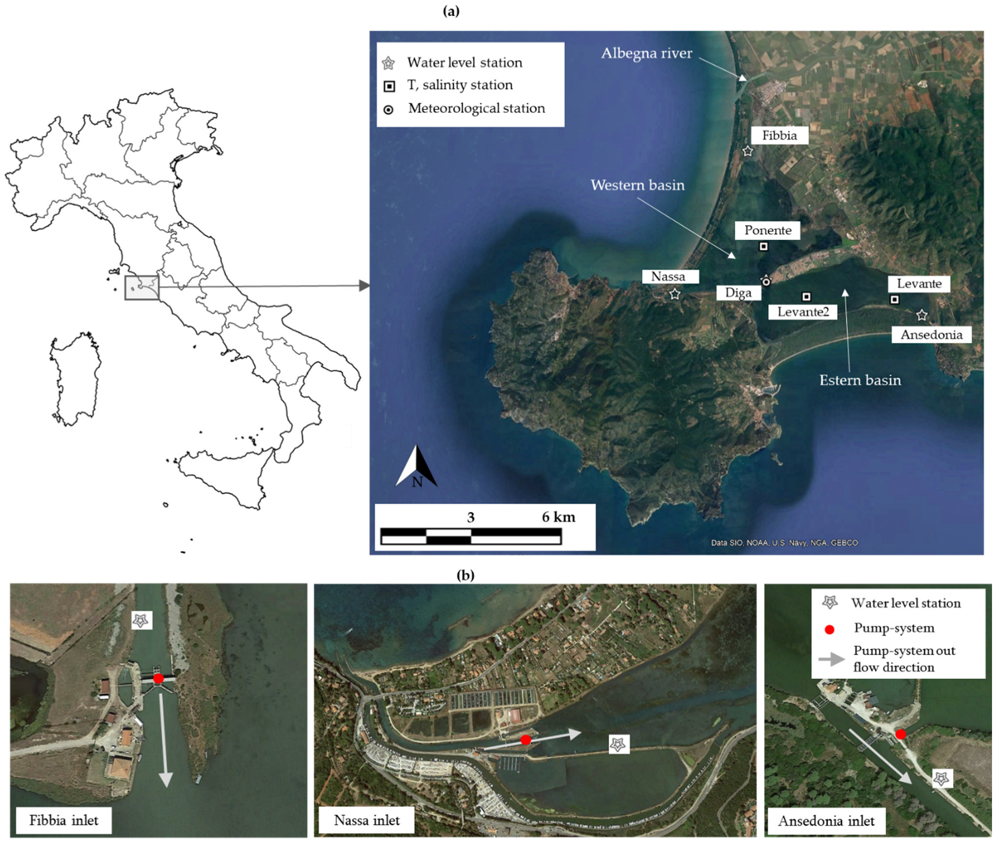
2.1. Framework of the Study Area

The Orbetello Lagoon is a partially enclosed coastal basin located at the southern end of the Tuscan coast (Italy), between 42°25′ and 42°29′ latitude north and 11°10′ and 11°17′ longitude east. It has an extension of 26 km2, a mean water depth of 1.13 m, and a total inner volume of water of about 30 Mm3. The lagoon is morphologically divided into two sub-basins, known as the western and eastern basins (Figure 1a).
The lagoon constitutes an intrinsically eutrophic environment [23]. At present, water exchange with the Tyrrhenian Sea takes place through three narrows inlets (Nassa, Fibbia, and Ansedonia inlets; see Figure 1), having a width of 15–20 m and a length of 1 to 2 km. The Fibbia inlet opens into the estuary of Albegna River (as highlighted in Figure 1a). It is worth pointing out that, in support of aquaculture activities conducted in the lagoon, a set of metal grids and gates extends along some transversal sections of each inlet and interacts with the tidal ebb and flood currents, lowering the water exchange with the open sea. Due to this scarce natural water renewal, forced pumping is used at the three inlets to artificially promote water exchange with the sea, particularly during spring and summer. The low thermal inertia of the shallow water environment causes drastic increases in the water temperature during the summer. The massive tourism activity and the intensive aquaculture in the lagoon are considered to be two of the main drivers for triggering the proliferation of macroalgae [15,27]. The algae species that populate the lagoon [28] act on the lagoon circulation as an additional roughness, consequently lowering the hydrodynamics, especially in the shallower areas. Algal bloom often occurs in spring, with consequent production of a high quantity of organic detritus which accumulates on the bottom of the lagoon. Such a phenomenon plays a crucial role in promoting anoxic crises. Land-based fish-farm wastewaters, agricultural run-offs, and nutrient loading accumulated in the sediment over past years as a consequence of untreated wastewater discharge from several civil and productive activities further aggravate the eutrophic state of the lagoon.
A protracted eutrophic crisis affected the lagoon in 1994, deeply injuring the environmental system. After that, the management of the lagoon was entrusted to a Government Authority, which implemented several strategies to improve the overall water quality, i.e., excavating canals on the bottom of the lagoon, removing nutrient inputs associated with civil wastewater, reinforcing pumping stations, and actuating periodical removal of algae from the lagoon waters [29]. After a first improvement, a progressive deterioration of the environmental conditions took place, with frequent algal blooms and anoxic episodes. Since 2013, the Tuscany Region Authority has been responsible for the lagoon management. At present, the management strategies adopted in an attempt to contain anoxic crises are mainly based on the following elements [30]: (i) pumping of seawater in/out the lagoon through the pumping stations (Figure 1b), (ii) systematically harvesting of macroalgae, and (iii) resuspending the sediment anoxic top layer with boats [31].
Water levels inside the lagoon are monitored at four measurement stations, three of which are installed at the lagoon inlets (i.e., Fibbia, Nassa, and Ansedonia stations; see Figure 1a) and one at the center of the lagoon (Diga station, Figure 1a). It is worth pointing out that the water-level gauges at Fibbia and Ansedonia stations are located on the seaward side of the system of grids and gates constituting fish-entrapment structures, while the gauge at Nassa is located on the lagoon-ward side of the local grids and gates system. The dynamic filtering effect of these structures on the lagoon tidal water-level fluctuation is evident in the available measurements. Data from Fibbia and Ansedonia level stations (Figure 2a) show that the semidiurnal tidal level oscillation reaches the terminal section of the respective lagoon inlets, at the location of the gauges, with a limited attenuation. On the contrary, measurements at Nassa and Diga (Figure 2b) show that the semidiurnal tidal wave is almost completely attenuated. In the latter stations, the only visible variations in water levels have longer characteristic periods, i.e., attributable mainly to large-scale atmospheric pressure fluctuations. To further support this evidence, normalized power spectra of water-level time series recorded at Fibbia and Nassa level gauges are compared in Figure 2c: peaks in the frequency spectrum corresponding to the lunar diurnal components O1 and K1 and to the principal lunar and solar semidiurnal (M2 and S2) and large lunar semidiurnal component N2 are visible in the power spectrum at Fibbia, while peaks at the same frequencies are absent in the spectrum obtained from Nassa signal.
Water temperature and salinity are continuously monitored by one station in the western basin (i.e., Ponente station; see Figure 1a) and by two stations in the eastern basin (i.e., Levante2 and Levante stations; see Figure 1a). The salinity in the lagoon varies from about 30 PSU in the winter months to about 45 PSU in the summer months, with a temperature range of approximately 5–35 °C. Hourly observation of meteorological parameters (wind, solar radiation, air temperature, relative humidity, precipitation, and clearness) is available from the meteorological station located on the Orbetello isthmus (denoted hereafter as Orbetello station; see Figure 1a).

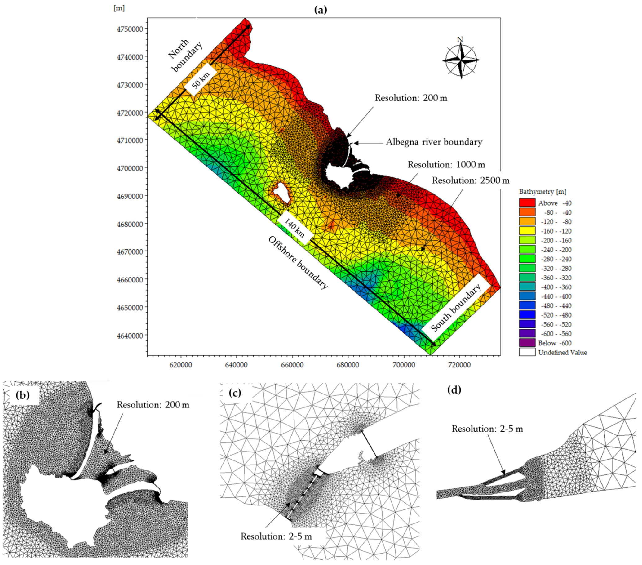
2.2. The Numerical Model

The numerical model uses the Hydrodynamic (HD) Flexible Mesh (FM) module of MIKE21 software package [32]. The model is based on the numerical solution of the two-dimensional, incompressible, Navier–Stokes equations under the hypothesis of Bussinesq and that of hydrostatic pressure distribution, which allows us to eliminate the vertical dimension from the three-dimensional equations, assuming to neglect the vertical acceleration of the flow (i.e., it solves the so-called Shallow Water Equations, SWEs). The model consists, therefore, of the equations of continuity and momentum integrated over the vertical (Equations (1)–(3)), with a turbulence closure scheme based on the eddy viscosity concept approach:
h t + h u ¯ x + h v ¯ y = 0
h u ¯ t + h u ¯ 2 x + h v u ¯ y = f v ¯ h g h η x h ρ 0 p a x g h 2 2 ρ 0 ρ x + τ s x ρ 0 τ b x ρ 0 + x ( h T x x ) + y ( h T x y )
h v ¯ t + h u v ¯ x + h v ¯ 2 y = f u ¯ h g h η y h ρ 0 p a y g h 2 2 ρ 0 ρ y + τ s y ρ 0 τ b y ρ 0 + x ( h T x y ) + y ( h T y y )
where the overbar indicates a depth average value; x and y are cartesian coordinates; t is the time; u and v are velocity components in the x and y directions, respectively; ƞ is the free surface elevation; h is the water depth; f = 2Ωsinϕ is the Coriolis parameter (being Ω is the angular rate of revolution and ϕ the geographic latitude); g is the gravitational acceleration; ρ is the water density; pa is the atmospheric pressure, ρ0 is the reference density of water; τsx, τsy, τbx, and τby are x and y components of surface wind and bottom stresses; and Tij are lateral stresses, which include viscous and turbulent friction and differential advection.
Transport–diffusion equations are also included for computing the transport of temperature and salinity. Density is a function of temperature and salinity only, with no dependence on pressure. Heat exchange with the atmosphere is also modeled.
The use of SWEs, mainly developed to be applied when the horizontal scale of the flow is much greater than the water depth and therefore the hydrodynamics is presumably dominated by bi-dimensional flows, is justified for the study of this coastal system since the Orbetello Lagoon is a relatively shallow water environment, having an almost flat horizontal bottom. At the same time, the two-dimensional SWE approach allows us to decrease the computational demands compared to three-dimensional modeling.
The model can handle an unstructured grid, with a flexible mesh approach which allows the reproduction of all the relevant physical phenomena taking place at the regional scale, as well as the detailed water circulation in the lagoon channels, with an acceptable computational effort. Governing equations are discretized with a cell-centered finite volume method. The spatial scheme uses an approximate Riemann solver to compute convective fluxes, thus making it possible to handle discontinuous solutions [33]. The temporal integration procedure for the conservation equations is based on an explicit scheme; thus, the time step adopted in the numerical computations must be limited based on the Courant–Friedrichs–Lewy (CFL) criterion.
The domain of the numerical model has an extension of 140 km (in the south–north direction) from Civitavecchia to Marina di Campo (Elba Island). The offshore boundary is almost parallel to the coastline and is located about 50 km offshore (Figure 3). The bathymetry data used were derived from bathymetry surveys of the area inside the lagoon (dating back to 2004), integrated with the digitalization of nautical paper charts (provided by Istituto Idrografico Militare) for the area outside the lagoon. The water depth inside Orbetello Lagoon has an average value of 1.13 m, with a maximum of 1.7 m.
The unstructured computational grid of the model is composed of around 40,000 triangular elements (slightly varying in the different simulated scenarios, due to the different geomorphological features of the lagoon to be reproduced). The size of the elements varies in the domain, with a maximum length of the cell of 2500 m offshore, gradually decreasing with a nested series of progressive refinements while approaching the lagoon (Figure 3). The smaller cell length is around 2 m, and it is used to discretize the lagoon inlets.
As for the numerical setup of the model, a uniform and constant value of the Gauckler–Strickler coefficient of 30 m1/3/s was imposed inside the lagoon for bottom friction. Such a constant value was chosen after sensitivity tests on the effect of different bottom roughness distributions, e.g., to reproduce the effect of the algae species not uniformly distributed in the lagoon bottom. No significant changes in the simulated water levels inside the lagoon and the sea–lagoon water volume exchange were observed; hence, a uniform constant value was used. A locally higher value of the Manning coefficient and ad hoc sections restriction was used in some sections of the lagoon inlets to calibrate the energy loss due to the presence of the grids and gates for fish entrapment, as detailed in Section 3.
The turbulence closure approach adopted is based on the use of a constant eddy viscosity value, imposed equal to 0.001 m2/s. The time step used in the simulation is dynamically adapted to maintain a CFL number lower than 0.8.
For both time and space integration, first-order upwind schemes are adopted. Such a choice was mainly motivated by the need to limit the computational time required for the simulations, and it is supported by the evidence that negligible differences in the variables of interest for this study were found by comparatively applying higher-order numerical schemes (while the computational time approximately doubles).
Time series of hourly water levels, temperature, and salinity, varying in space and time along each boundary, were used as offshore, north, and south boundary conditions (the naming convention for boundaries is reported in Figure 3a). Such data were extracted from the Mediterranean Sea Physics Analysis and Forecast database of Copernicus Monitoring Environment Marine Service (CMEMS) [34], a coupled hydrodynamic-wave model implemented over the whole Mediterranean Basin, which includes tides, with a grid resolution of 1/24°.
In order to examine the relative importance of different forcing mechanisms on the water exchange between sea and lagoon and on WRT, water levels due to astronomical tide only were also, alternatively, used as boundary conditions. Such data were extracted by the DTU Global Tide Model for Heights [35], which includes the following constituents: semidiurnal (M2, S2, K2, and N2); diurnal (S1, K1, O1, P1, and Q1); and shallow water (M4). Atmospheric data (wind, air temperature, relative humidity, solar radiation, precipitation, and clearness), which were needed to model the heat exchange with the atmosphere and assumed uniform over the domain, were based on hourly observation recorded at Orbetello meteorological station. The hourly time series of discharge of the Albegna River was also imposed as boundary condition at the relative boundary (Figure 3a).
As far as the initial conditions are concerned, null values of velocity and free surface elevation above the still water level were assigned to the whole computational domain, while the constant initial values for water temperature and salinity, uniform over the domain, were assigned based on data extracted from CMEMS database [34] in a representative point in the proximity of the north boundary of the domain.
Overall, within the aforementioned numerical setup, the computational cost of performing a 12 months long simulation is around 90 h (i.e., with a real-time-to-simulation-time ratio of 97.3), for a parallel run of 8 MPI processes on a desktop computer with an Intel (R) Core (TM) i9-9900 CPU with 8 cores, a clock speed of 3.10 GHz, and 32 GB of RAM.

2.3. Indexes of Water Transport Timescale and Water Renewal

The Orbetello Lagoon, as aforementioned, is susceptible to eutrophication issues. Water exchange with the open sea and, ultimately, WRT are fundamental physical parameters controlling the eutrophication of coastal basins [36]. Basins with poor flushing potential and long residence times tend to retain nutrients, while well-flushed estuaries are more resilient to nutrient loading [6]. No unique index to characterize the water renewal potential of lagoons or estuarine semi-closed basins exists.
For semi-enclosed basins, WRT is obtained from the solution of advection–diffusion equations [37,38]. Both Eulerian (e.g., in [39,40]) and Lagrangian particle tracking (e.g., in [6,38]) approaches have been applied to determine the WRT of lagoons with numerical hydrodynamic modeling. In the present study, an Eulerian approach is used to compute the WRT of the Orbetello Lagoon, releasing a passive tracer with an initial concentration C0 homogeneously distributed inside the lagoon, while imposing a concentration equal to zero on the seaward boundaries. The tracer is subject to advection and diffusion processes, and its concentration in each cell of the domain is sampled in time. The residence time in each position of the domain is computed as the time needed to lower the concentration to a factor 1/e of its initial value C0 (i.e., computing the e-folding time).
Another index of water transport timescale frequently adopted is the water flushing time (WFT), defined as the time theoretically needed to completely replace the volume of water with new sea (or river) water, under fully mixed conditions. The WFT can be defined as follows [41]:
W F T = V Q
where V is the total volume of water in the lagoon, and Q is the mean water inflow.
As suggested in [42], the ratio of WFT to WRT can be considered as an index of the mixing efficiency (ME) characterizing the coastal basin: for fully mixed systems, WRT coincides with WFT and ME = 1, while for the opposite case of ME = 0, no mixing would occur between water masses entering the lagoon and inner lagoon waters. In this study, WFT was computed based on the estimation of the mean water inflow, Q, obtained from the numerical model.

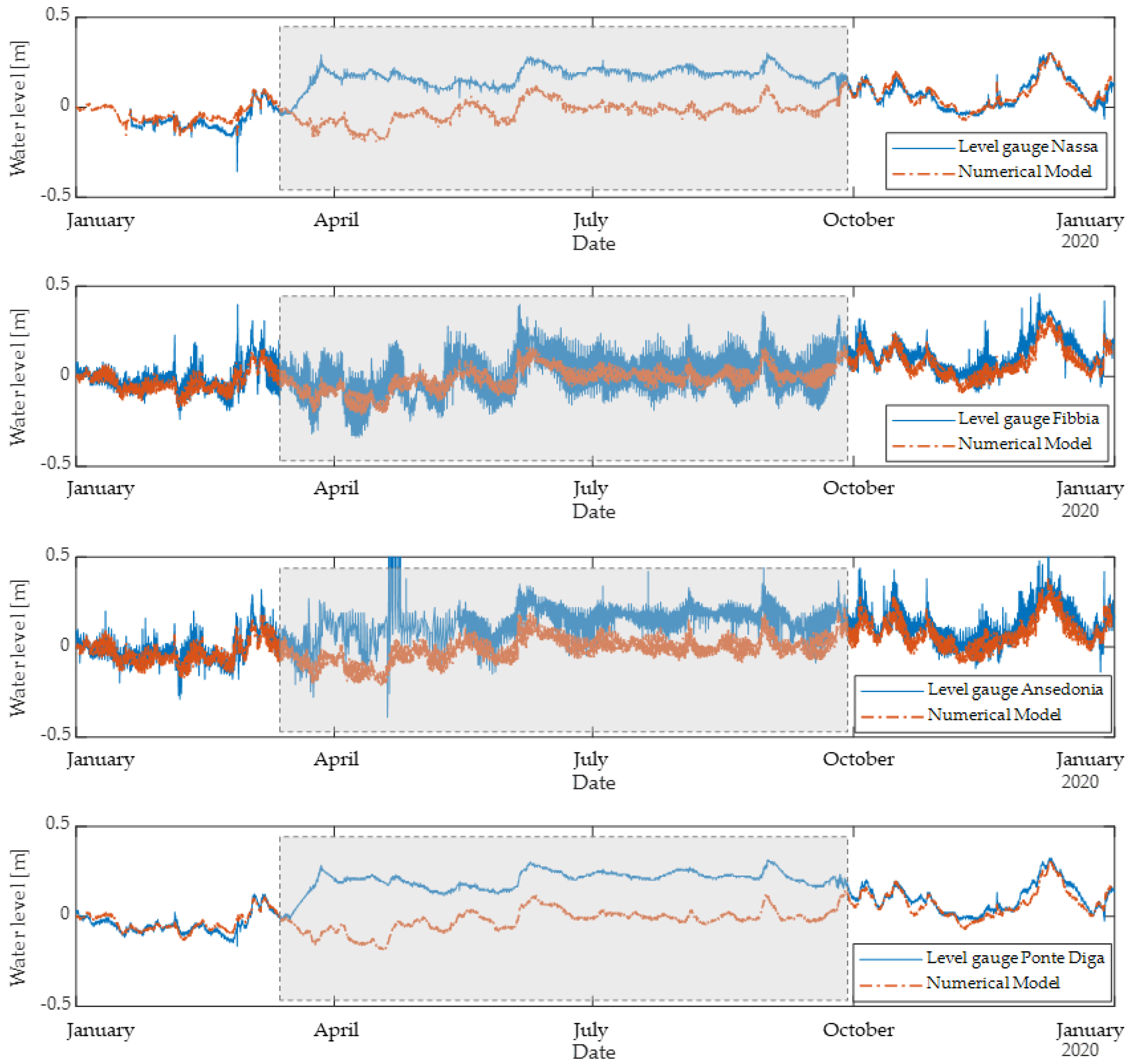
3. Validation and Calibration of the Numerical Model

The numerical model of the lagoon hydrodynamics, forced with water levels (or discharge, for the Albegna River boundary), temperature, and salinity at the boundaries and subjected to uniformly distributed meteorological forcings (i.e., wind, precipitation, air temperature, humidity, and clearness), as described in Section 2, is validated by comparing predicted water levels, temperature, and salinity with the available measurement from field sensors. The comparison is carried out considering hourly measurements for the year 2020 (Figure 4, Figure 5 and Figure 6).
As aforementioned, the presence of the system of gates and grids in the lagoon inlets causes significant momentum and energy losses. To introduce in the model such additional resistance to the flow, a localized decrease of the cross-sectional channel area to approximately 1/3 of its undisturbed value was used, with a local higher value of Gauckler–Strickler coefficient of 20 m1/3/s. The degree of contraction in the cross-sectional geometry and the additional roughness have been calibrated in order to achieve a satisfactory agreement with the level data measured at the stations in their respective inlets. This morphology configuration, which includes the aforementioned additional roughness and contraction in the cross-section to mimic the presence of the gates and grids systems, is referred to, hereafter, as present scenario (PS). For comparative purposes, simulations are performed also with the current morphology of the lagoon inlets and bathymetry, without any artificial obstacle to the flow. Such a configuration is referred to, hereafter, as a present scenario with open inlets (PSOI), as detailed in Section 4.
As far as water levels are concerned, excluding periods in which the pumping systems were active (indeed, the pumping systems are not implemented in the numerical model so far), a satisfactory agreement is found between field measurements and simulation results at the different monitoring stations (Table 1 and Figure 4). The Root Mean Square Error (RMSE) varies between 0.024 m (for Ponte Diga station, at the center of the lagoon) and 0.043 m (at Fibbia station), with correlations coefficients R of 0.93–0.96 (Table 1).
Both the temperature seasonal variability and the amplitude of the daily temperature oscillation are well reproduced by the numerical model (Table 2 and Figure 5), with a RMSE between 1.19 °C (for Ponente station) and 1.52 °C (at Levante station) and R of 0.93–0.97. Worth mentioning that a general decrement of the agreement between the numerical model results and the temperature measurements is obtained in the summer months, possibly due to a non-negligible effect of the pumping systems which introduce colder water from the sea. This effect is particularly evident when comparing model results and measurements at Ponente station (Figure 5), which is located at the center of the western basin, i.e., under the influence of the two pumping systems installed at Fibbia and Nassa inlets: in the summer months, temperatures predicted by the numerical model are up to 2 degrees higher than the observed ones. Therefore, the results of the model seem to suggest that the pumping system might allow for a decrease in temperature in the lagoon waters (limited to a maximum of 2 °C).
For salinity, the RMSEs of 3.19–4.24 PSU between simulation results and observations are obtained, with R values of 0.78–0.83 (Table 2 and Figure 6). The numerical model is able to capture the seasonal trend of salinity, with the progressive increase from the winter values of around 30 PSU (i.e., lower in the lagoon than in the open sea) to the higher summer values of around 45 PSU, determined by a progressive increase of the evaporation in the lagoon. Groundwater and runoff contributions to freshwater inputs were not included in the numerical model yet, possibly determining the reduced rate of decrease of salinity in the winter months observed in the numerical model compared to measurements.
The performance of the model, in terms of agreement with data from field monitoring, can be considered satisfactory also in relation to validation results recently reported in the literature for similar modeling studies: for Mar Menor, Garcia-Oliva et al. [43] obtained RMSE values of 1.20–2.75 °C and 0.84–1.34 PSU for temperature and salinity, respectively; for the Oualidia lagoon, Elyaagoubi et al. [44] obtained values of RMSE for salinity between 1.76 and 3.87 PSU; and for the Obidos Lagoon, Mendes et al. [45] documented RMSE-values of 1.02–2.93 °C for temperature and 0.76–3.26 PSU for salinity.

4. Historical Scenarios Selected for the Hindcast

The validated model was used as a hindcast tool, with the aim to evaluate the role of the lagoon morphology, which is essentially determined by anthropic actions and management strategies, on the lagoon circulation and water exchange with the sea. For this purpose, the lagoon morphology in a set of key scenarios over the last two centuries was characterized by analyzing the available historical documentation and cartography. The lagoon hydrodynamics, resulting as a response to the same external forcing in the different scenarios, was then simulated. The key features of the considered scenarios can be summarized as follows (Figure 7):
(i) The 1824 scenario was mainly characterized based on cadastral maps. In this scenario, three inlets connected the lagoon with the open sea: Nassa and S. Liberata inlets (with a length of around 750 m, and an average section width of 12–15 m, Figure 7a), located on the west side of the western basin; and Fibbia in the north (with a length of 1400 m, an average width of 7 m). The lagoon, as well as the lagoon inlets, had an average water depth of around 1.3 m. At the lagoon center, two channels were present on the Orbetello isthmus, providing a hydraulic connection between the western and eastern basins (namely Fosso Reale and Fosso Glacis).
(ii) In 1862, only two inlets were present, since the Fibbia inlet had been closed. This decision was probably motivated by the will to isolate the lagoon from Albegna River, into the estuary of which Fibbia inlet opened, considered one of the main sources of nutrients load into the lagoon. Nassa and S. Liberata had a narrower cross-section in the proximity of the confluence into the lagoon, compared to the 1824 scenarios, with a minimum width of 10 m (Figure 7b). Moreover, an artificial embankment dam, with an upstanding driveway, was built in the central lagoon, connecting the Orbetello isthmus to the prospicient peninsula, the so-called Ponte Diga (Figure 7c). The Ponte Diga embankment, with a length of 980 m and a width of 15 m, had only three underwater openings, 13 m wide each, to allow for the water circulation between the western and eastern basins. Fosso Reale and Fosso Glacis were still present on the Orbetello isthmus, with similar morphology with respect to the 1824 scenario.
(iii) Closing the Fibbia inlet led to a drastic increase in the anoxic crises in the northern part of the lagoon, leading to the decision to reopen the inlet just some years later. Therefore, in the 1907 scenario (Figure 7d–f), four inlets connected the lagoon and the sea, with Fibbia operating again (with an increased width, up to about 20 m; a length of 2600 m; and an average depth of 1.5 m) and a new inlet, Ansedonia, was excavated in the eastern basin (1500 m long, 20 m wide). Moreover, five more underwater openings were realized across the Ponte Diga, and a waterway was excavated on the lagoon bottom, connecting the Nassa inlet to the Orbetello isthmus. The average water depth in the lagoon was about 1.4 m.
(iv) In the present scenario (PS), Figure 7g–i, the S. Liberata channel has been completely closed to host a tourist harbor. The lagoon’s average water depth is around 1.13 m. Overall, the present morphology of lagoon inlets was presented in Section 2. As aforementioned, the present scenario (PS) includes the additional roughness and inlet cross-section contractions to reproduce the effect of the gates and grids system for fishing purposes, partially occluding each inlet.
(v) For comparative purposes, the current bathymetry of the lagoon and morphology of the inlets, without the additional obstacles to the flow determined by the grids and gates installed in the inlets (scenario PSOI), were also analyzed.

5. Results

The hydrodynamics, water transport timescale, and water exchange with the sea under the same forcing conditions were simulated for the five scenarios. To allow for the characterization of water transport timescales for the lagoon, 12 months long simulations were carried out (with a 1-day warm-up period to allow for a gradual introduction of hydrographic forcings, avoiding numerical shocks), using as boundary conditions and meteorological forcing data of the year 2020. In the analysis of the present lagoon configuration, a quantitative evaluation of the relative importance of different forcing mechanisms on the water renewal is also carried out (Section 5.1). The comparison is then extended to the historical lagoon morphology scenarios in Section 5.2.

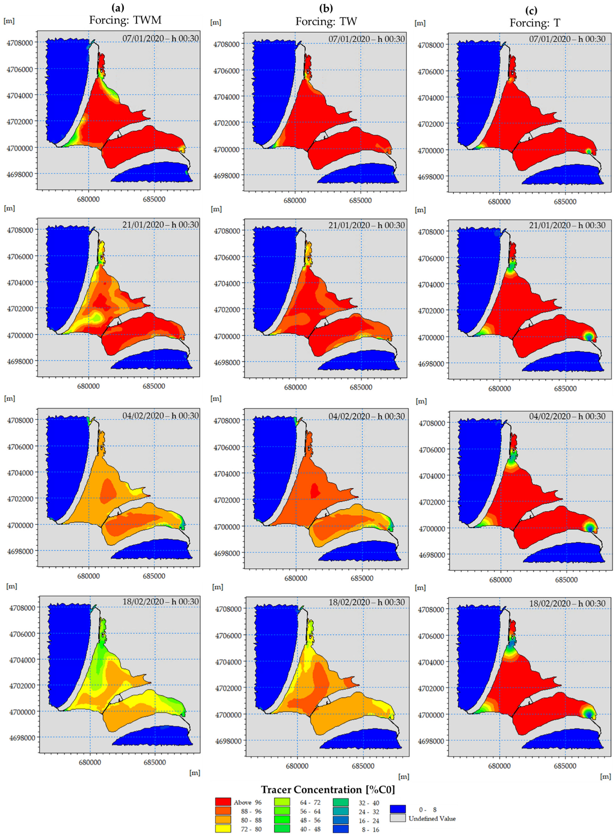
5.1. Analysis of the Present Scenario

The present configuration of the Orbetello Lagoon, with (present scenario, PS) and without (scenario PSOI) the gate and grid obstacles in the terminal section of the inlets, is analyzed at first, considering different forcing mechanisms, i.e.,: astronomical tide (T), wind (W), and meteorological tide (M). It is worth mentioning that the discharge of the Albegna River was imposed identically in all the simulated scenarios. The results of the numerical simulations in terms of water inflow at the inlets, average daily volume entering the lagoon, fraction of the total lagoon volume daily exchanged with the sea (FVE), water flushing time (WFT), water residence time (WRT), and mixing efficiency (ME), defined as in Section 2.2., are provided in Table 3. The average value of WRT of the lagoon was determined as the weighted average of the WRT computed for each computational cell in the domain (obtained with the methodology described in Section 2.2), with weights being the area of the respective cell.
In the present scenario with gate and grid obstacles in the inlets, i.e., scenario PS, under the full set of forcing mechanisms (TWM code, i.e., including astronomical and meteorological tide and wind), the lagoon is characterized by an average value of the total inflow through the inlets of 7.3 m3/s (Table 3). A total of 65% of the water exchange between the open sea and the lagoon takes place through the Nassa inlet (having an average water inflow 4.8 m3/s), 25% through the Fibbia inlet, and 10% through the Ansedonia inlet. The daily volume of seawater entering the lagoon has a mean value of around 664 × 103 m3, with an FVE of 0.022. The water flushing time (WFT) computed based on these numerical results has a value of 46 days. The average water residence time (WRT) of the lagoon in scenario PS is 230 days. As introduced in Section 2.2, the difference between WFT and WRT is a consequence of the limited efficiency of the mixing processes inside the lagoon (with ME = 0.2). Recalling that ME values equal to 1 would imply fully mixed conditions, while ME = 0 corresponds to practically no mixing between the inner lagoon water and the seawater entering through the inlets, it is apparent that, in the present morphology of the lagoon (scenario PS), under WTM forcing, as in Table 3), a great fraction of the water daily exchanged with the open sea does not mix with the inner waters; that is, water renewal processes are bounded in space to limited areas close to the inlets.
Comparatively considering the present lagoon morphology, without the presence of the system of gates and grids in the inlet (scenario PSOI), under the same set of forcing mechanisms (code TWM), the total average water inflow through the inlets is 9.4 m3/s, showing, therefore, an increase of 23% compared to scenario PS. The FVE increases to 0.028, with a consequent decrease of the flushing time (WFT) to 36 days (i.e., 28% lower than in the present scenario, PS). Even more evident is the effect on the average water residence time (WRT), which is reduced to 106 days. The gates and grids system in the inlets has a fundamental effect in determining the average basin hydrodynamics and water renewal, affecting not only the water flux through the inlets but also the efficiency of the mixing process: in scenario PSOI, an ME of 0.34 is obtained, with a relative increase of around 40% regarding the value in scenario PS.
Coastal systems with complex morphology generally have a heterogeneous distribution of the areas where waters are either well or poorly mixed [42]. Maps showing the spatial distribution of WRT allow us to individuate such different areas. Previous studies in the literature (e.g., [46]) showed that poorly circulated and stagnant zones are highly sensitive to stressors.
Figure 8 provides the distribution of WRT in scenarios PS and PSOI, under TWM forcing conditions. In scenario PS (Figure 8a), most of the eastern basin is characterized by a WRT > 250 days (reaching peak values of around 350 days in some northeast areas of the basin). In the western basin a wide poorly circulated stagnant area (WRT > 250 days) in the lagoon center is found, with an additional critical area on the northern side of the basin. Such areas, characterized by poor flushing potential, are supposedly particularly prone to the development of hypoxic conditions [4]. Scenario PSOI (Figure 8b) shows a significantly different distribution of the WRT in the two lagoon basins, with a maximum value (lower than 175 days) in the center of the western basin. The maximum WRT in the eastern basin is lower than 140 days. The presence of the grids and gates system in the inlets, therefore, fundamentally also alters the WRT distribution in the lagoon, determining the areas where the most critical conditions are located.
A second set of simulations explores the dependence of the water transport timescale on the different forcing mechanisms. For this purpose, for scenario PSOI, simulations with the only forcing mechanism of water level variations induced by the astronomical tide (code T) and with the forcing of astronomical tide and wind (code TW) were also carried out. The results are reported in Table 3. The average daily volume exchanged with the sea through the inlets, the flushing time (WFT), and the daily exchange fraction of the lagoon volume (FVE) have a relative difference lower than 2% under the three different forcing conditions. The astronomical tide is therefore the major driver of the water exchange through the inlets on a daily basis. The mixing processes inside the lagoon, which ultimately determine the overall water renewal, are, on the contrary, fundamentally governed by the wind and the meteorological tide. Indeed, excluding wind and meteorological tide forcing (i.e., code T in Table 3) would result in an average WRT for the lagoon > 780 days, with a mixing efficiency ME < 0.05. It is also worth mentioning that results for scenario PSOI under the only forcing of the astronomical tide were obtained by extending the simulation period to 36 months, due to the remarkably higher water transport timescales. Nevertheless, at the end of the simulated time period, the concentration of the tracer in the lagoon was still higher than the reference value of 1/e∙C0 on 75% of the lagoon area (i.e., in these areas, the WRT is higher than the simulated time). To obtain the lower bound estimation of the WRT reported in Table 3, a WRT equal to the simulation time was assumed in the aforementioned areas.
Adding the wind forcing to the astronomical tide (code TW in Table 3) results in a decrease of the WRT to a value of 224 days, with a consequent increase of ME to 0.16.
Large-scale variations in the water levels induced by meteorological effects (e.g., atmospheric pressure changes) seem to be the dominant forcing mechanism for the mixing processes inside the lagoon: adding also this forcing mechanism, the WRT in the lagoon halves, as evident when comparing results for scenario PSOI under TWM and TW forcings, having an average WRT of 106 and 224 days, respectively; that is, more than 50% of the WRT reduction is determined by the meteorological tide.
The effect of different forcing mechanisms on the lagoon hydrodynamics and water renewal can be further analyzed by comparing the tracer concentration in the lagoon (expressed as a percentage of initial concentration, C0) at the same instant in time in scenario PSOI, under the different forcings (Figure 9). Under forcing conditions TWM and TW (Figure 9a,b), the mixing processes of the inner lagoon water cause a progressive dilution of the tracer concentration as the tidal-induced water exchanges through the inlets progresses: after 7 weeks, concentrations are reduced to values lower than 88% (for TWM forcing) and 96% (for TW forcing) of C0 over the whole lagoon area. Considering only the astronomical tide forcing T (Figure 9c), the water renewal due to the daily water exchange through the inlets is limited to an extent of some hundred meters in front of the inlet itself and does not involve the inner lagoon waters: after 7 weeks, the tracer concentration is approximately still equal to the initial concentration, C0, over most of the coastal basin.

5.2. Comparative Analysis of the Selected Hindcast Scenarios
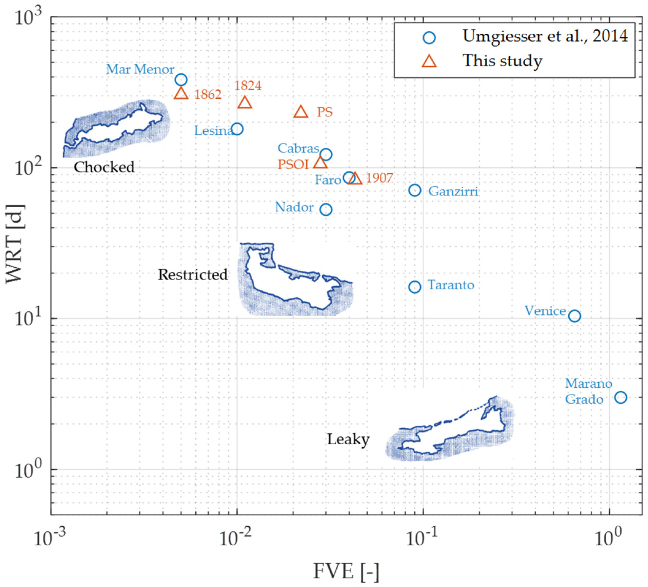
The water fluxes exchanged at the inlets and water transport timescale parameters in the different hindcast scenarios are provided in Table 4.
The highest value of average inflow through the inlets (14.7 m3/s) was obtained for the 1907 scenario, having an FVE of 0.043. The average flux in the present scenario PS is only 50% of this maximum value (while the FVE is reduced to 0.022 in the present scenario). The higher water exchange value obtained for the 1907 scenario is connected to the following key morphological features of the lagoon: all four lagoon inlets (i.e., Nassa, S. Liberata, Fibbia, and Ansedonia) were connecting the lagoon to the open sea, the waterway excavated on the lagoon bottom was present along the western basin, and eight underwater openings were present on Ponte Diga embarkment at the lagoon center. In the earliest among the past reconstructed scenarios, i.e., that of 1824, characterized by the presence of Nassa, S. Liberata, and Fibbia inlets in the western basin, an average water inflow through the inlets of 3.9 m3/s was obtained, with an FVE of 0.011. The lowest water exchange values are that of the 1862 scenario, having the minimum average water inflow (1.8 m3/s), i.e., with a decrease of around 87% compared to the 1907 value. The 1862 scenario was characterized by the presence of Nassa and S. Liberata inlets only, since the Fibbia inlet had been closed. Moreover, Nassa and S. Liberata inlets had a narrower cross-section compared to that of 1824, explaining the decrease of the average water inflow through these inlets compared to 1824’s values (3.2 m3/s and 1.8 m/3 in 1824 and 1864, respectively).
The opening of the Ansedonia inlet in the 1907 scenario emerges as a crucial factor in the system’s hydrodynamic activity and water renewal. Further evidence of its fundamental role is that, since its first opening, 10% to 25% of the water enters the lagoon through this inlet in the different simulated scenarios. As a comparison, the Fibbia inlet contributes to around 20–30% of the water inflow, while the Nassa inlet transports from 50% to 60% of the total water entering the lagoon during each tidal cycle. Furthermore, considering scenario PSOI, the water flux through the inlets in the western basin is only 65% of its value in the 1907’s scenario. The most relevant morphological changes regarding the 1907 scenario are the closure of S. Liberata channel and a narrowing of the section of Ansedonia inlets in the proximity of its confluence into the lagoon. Such anthropological interventions on the lagoon morphology have, therefore, a determinant effect on the hydrodynamics of the lagoon.
A minimum water flushing time (WFT) of 23 days was attained in the 1907 scenario, while the maximum WFT in the 1862 scenario is 184 days. The residence time (WRT) varies between 83 days (in the 1907 scenario) and 305 days (in the 1862 scenario), with mixing efficiencies ME = 0.28 and 0.60, respectively.
The distribution of WRT over the lagoon area in the past scenarios of 1824, 1862, and 1907 is delivered in Figure 10 (while, for comparative purposes, the present scenario (PS) and PSOI are depicted in Figure 8).
In the 1824 scenario, WRTs higher than 360 days (with maximum values of around 430 days) are found over almost half of the eastern basin. In the western basin, instead, the WRT is lower than 350 days almost everywhere (Figure 10a), except in a limited area north of the Orbetello isthmus (having a WRT around 400 days).
In the 1862 scenario (Figure 10b), the one with the lowest hydrodynamic activity in terms of water exchange with the sea, the extent of the areas characterized by very high WRT > 350 days) increases significantly compared to the previous one. Stagnant areas cover practically the total extent of the eastern basin, where WRT reaches values of 470 days. The absence of Fibbia inlet in the western basin also causes a drastic increase of WRT in this zone of the lagoon: almost 50% of the basin has a WRT > 350 days (with maximum values up to 460 days in the areas furthest from the Nassa inlet).
In the best-performing scenario in terms of water exchange (that of 1907, Figure 10c), a maximum WRT of about 120 days is found in the central lagoon, both in the western and eastern basins. Overall, contrary to what occurs in the previous scenarios, the average WRT is higher in the western basin than in the eastern one, confirming the fundamental role of the Ansedonia inlet (simulated as fully unobstructed, without grids and gates obstacle, in the 1907 scenario) in the water transport timescale of the basin. As discussed in Section 5.1, in the present scenario (PS), which includes the gates and grids obstacle in the inlets, the average WRT is again remarkably higher in the eastern basin than in the western one.
Moreover, comparing maps of WRT distribution for the 1824 and 1864 scenarios, it is worth noting that the presence of the Ponte Diga embankment in the lagoon center causes an evident increase of WRT in this area in the 1864 scenario.

6. Discussion

The values of WRT obtained for the present and past scenarios for the Orbetello Lagoon, with and without the system of gate and grid obstacles posed in each inlet as fishing infrastructures, and under different drivers to the lagoon hydrodynamics, were found to vary between 83 days (in the 1907 scenario, under tidal and wind forcing) and values higher than 780 days (in the PSOI scenario under astronomical tide forcing only). Previous studies in the literature dealing with hydrodynamic circulation, mixing processes, and water exchange in coastal lagoons confirm such a great variability in the estimated WRT, with values around 3 days for Porto Lagos (Greece) [47], around 43 days for Albufera de Valencia (Spain) [48], from 10 to 15 days for Venice Lagoon (Italy) [38,42], and higher than 300 days for Mar Menor (Spain) [42,43].
As proposed in Kjervfe et al. [49], the hydrodynamics and geomorphology of coastal lagoons allow us to classify them into leaky, restricted, or choked systems, with leaky basins being characterized by the shortest turnover time and choked systems by the longest ones. Umgiesser et al. [42] comparatively studied the water transport timescale of 10 Mediterranean lagoons, stressing the wide variability of their hydrodynamic behavior and classifying them according to the proposal of Kjerve et al. [49], i.e., based on WRT and FVE. Even if the distinction among hydro-morphological types is not clearcut, the results of their study found that some of the considered Mediterranean lagoons were classifiable as choked (e.g., Marano-Grado lagoon, Italy), restricted (e.g., Taranto Sea, Cabras, Faro, and Ganzirri lagoons) or intermediate types (e.g., Lesina, Varano, and Venice). Applying the same method with the numerical results of the present study, the Orbetello Lagoon can be classified, in the different considered scenarios, as an intermediate type between the chocked and restricted cases (Figure 11). In the geomorphology scenario of 1862, the Orbetello Lagoon approached the chocked case, while in both the scenario of 1907 and the present one without the obstacles of fish entrapment structures in the inlets (PSOI scenario), the hydro-morphological conditions are closer to the restricted case.
It is worth noting that higher values of mixing efficiency (ME) are found when the lagoon conditions approach that of a chocked basin: the 1862 scenario has an ME of 0.6, the highest value among the estimated ones for Orbetello Lagoon. Relatively high values of ME (greater than 0.5) were found for chocked basins also by Umgiesser et al. [42]. In such hydro-morphological conditions, the exchange with the open sea is very low, and the wind has enough time to mix the basin, therefore increasing the observed ME. Indeed, the previous literature studies confirmed that winds are usually one of the dominant forcing mechanisms in the water mixing of clocked lagoons, contributing to both the flushing with the sea and the internal mixing of the lagoon waters. The relevance of the wind forcing and, even more evidently, of the meteorological tide forcing mechanism has been confirmed in the present study and can be further highlighted considering that when all the forcing mechanisms are included in the simulations (astronomical tide, meteorological tide and wind), the average WRT in the inner lagoon areas is around 305 days under the most chocked conditions (1864 scenario, when only Nassa inlet in the western basin was connecting the lagoon to the open sea). When only the tidal forcing is included, instead, a WRT > 780 days is obtained, even in a geomorphological scenario comprising 3 active and unobstructed lagoon inlets (i.e., in PSOI scenario; see Table 2).
The remarkably different hydrodynamic behavior of the lagoon in the different simulated scenarios, having dissimilar geomorphological features, suggests that the role of anthropic interventions on the lagoon morphology is crucial in the long-term management of this coastal basin. Such interventions (e.g., dredging operation, reshaping of lagoon inlets, and re-opening of inlets which are closed at present) could be exploited in synergy with the short-term management strategies adopted today to improve the water quality (i.e., pumping of seawater through the inlets, harvesting macroalgae, and resuspending the top layer of the sediment with boats).
It is worth mentioning that the numerical model used to assess the water transport timescale of the lagoon does not include runoff and groundwater inputs. The effect of such freshwater sources on salinity levels in the lagoon and on water residence time will be addressed in future research. In particular, for salinity, values of RMSE of 3.2–4.2 PSU between simulations and observations were documented in Section 3, with a tendency toward an overestimation of salinity in autumn–winter which could be induced by the lack of the aforementioned freshwater inputs. Moreover, this relatively high discrepancy in measured and simulated salinity levels could also be a result of the vertical integration of the flow quantities applied in the numerical model, when compared with field point measurements at a given water depth. At present, no field measurements are available to assess whether significant stratification phenomena take place in the lagoon; therefore, future developments of the present work should also evaluate possible differences between bottom and surface values of the quantity of interest, obtaining field measurements at different depth along the water column of the quantity of interest and comparatively applying three-dimensional modeling approaches.
It is finally worth mentioning that the choice of not including in the simulations of this work the forced pumping systems installed in the lagoon inlets is mainly motivated by the will to specifically investigate the primary drivers of the water exchange between the lagoon and the sea under natural (i.e., not man driven) conditions. Given the relevance of such an anthropic forcing on the system dynamics, a future implementation of the model will also include the simulation of pumping systems, also in the perspective of further developing the numerical model as an operational tool for aiding the lagoon management, in both the short and long-term decision-making processes.

7. Conclusions

This work presents the results of a numerical study which reproduces the hydrodynamics and investigates the typical water transport timescales of the Orbetello Lagoon, a partially enclosed coastal basin that is highly susceptible to eutrophication issues. The numerical model, once validated with field measurements, was used to reconstruct the response of the lagoon to the major geomorphological changes over the last two centuries (i.e., variation in the number and geometry of the lagoon inlets, variation of the depth of channels excavated on the bottom, presence and morphological features of the embarkment separating the western and eastern basins, and presence of gates and grids system in each inlet) and to assess the relative importance of different forcing mechanisms on the hydrodynamic activity of the basin. In this way, it was possible to quantitatively evaluate the effect of anthropic actions on the system hydrodynamics, consolidating the necessary background knowledge to support the present and future management of such a complex environmental system.
Among the different forcing mechanisms comparatively examined (i.e., astronomical and meteorological tide and wind), the astronomical tide was found to be the major driver of the water exchange through the inlets on a daily basis. The mixing processes inside the lagoon, which ultimately determine the overall water renewal, are, on the contrary, fundamentally governed by the meteorological tide, which has a dominant role, and by the wind, having a relevant influence as well.
Including the full set of forcing mechanisms, the level of natural water renewal, expressed in terms of average water volume entering the lagoon in a tidal cycle, is strongly related to the number and morphology of the lagoon inlets: the total volume obtained in the best performing scenario (that of 1907, characterized by four active lagoon inlets), is almost eight times higher than that obtained with only two operating inlets (i.e., in the 1862 scenario). The minimum water residence time determined in the best scenario is 83 days. The residence time in the present scenario is almost three times higher (230 days).
The model application revealed that the extent of poorly circulated stagnant areas, characterized by poor flushing potential and high water residence time, is strongly influenced by both the number and morphology of lagoon inlets and openings on the artificial embankment dam located at the center of the lagoon. Such areas are highly susceptible to developing anoxic crises and degradation of the water quality since they can correspond to hot spots of organic content in the bottom sediment [5]. Moreover, the gates and grids system posed in the inlet as fishing infrastructures have a fundamental effect in drastically lowering the basin water renewal, affecting not only the average water flux through the inlets, but also the efficiency of the mixing process. The gates and grids system in the inlets also fundamentally alter the WRT distribution in the lagoon, determining the areas where the most critical conditions are located. In the present scenario, the model also allowed us to estimate that reopening the S. Liberata inlet, in the western basin, would significantly increase the water renewal, with a non-negligible impact in terms of improvement of the lagoon–sea water exchange. Variations in the inlet morphology could, therefore, contribute to attenuating eutrophication symptoms.
The quantitative predictions of water exchange and circulation obtained with the numerical model provide a pivotal base of knowledge to solve the long-lasting debate about the more suitable management strategies to cope with the poor lagoon circulation. Although based on a specific case study, the knowledge obtained from the present study could promote the efficient management of similar eutrophic semi-enclosed coastal systems worldwide.
The hydrodynamic model will also be coupled to ecological modeling, allowing a comprehensive simulation of the specific processes related to the eutrophication of the lagoon, providing the long-range prediction capability required for developing a decision support system.

Author Contributions

Conceptualization, L.C.; methodology, I.S. and L.C.; validation, I.S. and L.C.; formal analysis, I.S.; investigation, I.S. and L.C.; data curation, I.S. and L.C.; writing—original draft preparation, I.S. and L.C.; writing—review and editing, I.S. and L.C.; visualization, I.S.; funding acquisition, L.C. All authors have read and agreed to the published version of the manuscript.

Funding

This work was supported by the European Union-FSE-REACT-EU, PON Research and Innovation 2014–2020, D.M. 1062/2021, Contract Number 10-G-15057-1.

Institutional Review Board Statement

Not applicable.

Informed Consent Statement

Not applicable.

Data Availability Statement

Data available on request.

Acknowledgments

The Tuscany Region Authority is gratefully acknowledged for providing the data used for validating the numerical model. Stefano Solari is also kindly acknowledged for his contribution to collecting the historical documentation on the lagoon morphology in past scenarios.

Conflicts of Interest

The authors declare no conflict of interest.

References

  1. Umgiesser, G.; Zemlys, P.; Erturk, A.; Razinkova-Baziukas, A.; Mėžinė, J.; Ferrarin, C. Seasonal renewal time variability in the Curonian Lagoon caused by atmospheric and hydrographical forcing. Ocean Sci. 2016, 12, 391–402. [Google Scholar] [CrossRef] [Green Version]
  2. Kennish, M.J.; Paerl, H.W. (Eds.) Coastal Lagoons: Critical Habitats of Environmental Change; Marine Science Series; Taylor & Francis: Boca Raton, FL, USA, 2010; ISBN 978-1-4200-8830-4. [Google Scholar]
  3. Lillebø, A.I.; Stålnacke, P.; Gooch, G.D.; Krysanova, V.; Bielecka, M. Pan-European management of coastal lagoons: A science-policy-stakeholder interface perspective. Estuar. Coast. Shelf Sci. 2017, 198, 648–656. [Google Scholar] [CrossRef]
  4. Deb, S.; Guyondet, T.; Coffin, M.R.S.; Barrell, J.; Comeau, L.A.; Clements, J.C. Effect of inlet morphodynamics on estuarine circulation and implications for sustainable oyster aquaculture. Estuar. Coast. Shelf Sci. 2022, 269, 107816. [Google Scholar] [CrossRef]
  5. Sinha, E.; Michalak, A.M.; Balaji, V. Eutrophication will increase during the 21st century as a result of precipitation changes. Science 2017, 357, 405–408. [Google Scholar] [CrossRef] [Green Version]
  6. Defne, Z.; Ganju, N.K. Quantifying the Residence Time and Flushing Characteristics of a Shallow, Back-Barrier Estuary: Application of Hydrodynamic and Particle Tracking Models. Estuar. Coasts 2015, 38, 1719–1734. [Google Scholar] [CrossRef]
  7. Coffin, M.R.S.; Courtenay, S.C.; Pater, C.C.; van den Heuvel, M.R. An empirical model using dissolved oxygen as an indicator for eutrophication at a regional scale. Mar. Pollut. Bull. 2018, 133, 261–270. [Google Scholar] [CrossRef]
  8. Clunies, G.J.; Mulligan, R.P.; Mallinson, D.J.; Walsh, J.P. Modeling hydrodynamics of large lagoons: Insights from the Albemarle-Pamlico Estuarine System. Estuar. Coast. Shelf Sci. 2017, 189, 90–103. [Google Scholar] [CrossRef] [Green Version]
  9. Mallinson, D.J.; Smith, C.W.; Culver, S.J.; Riggs, S.R.; Ames, D. Geological characteristics and spatial distribution of paleo-inlet channels beneath the outer banks barrier islands, North Carolina, USA. Estuar. Coast. Shelf Sci. 2010, 88, 175–189. [Google Scholar] [CrossRef]
  10. Luettich, R.A.; Carr, S.D.; Reynolds-Fleming, J.V.; Fulcher, C.W.; McNinch, J.E. Semi-diurnal seiching in a shallow, micro-tidal lagoonal estuary. Cont. Shelf Res. 2002, 22, 1669–1681. [Google Scholar] [CrossRef]
  11. Panda, U.S.; Mohanty, P.K.; Samal, R.N. Impact of tidal inlet and its geomorphological changes on lagoon environment: A numerical model study. Estuar. Coast. Shelf Sci. 2013, 116, 29–40. [Google Scholar] [CrossRef]
  12. Ferrarin, C.; Ghezzo, M.; Umgiesser, G.; Tagliapietra, D.; Camatti, E.; Zaggia, L.; Sarretta, A. Assessing hydrological effects of human interventions on coastal systems: Numerical applications to the Venice Lagoon. Hydrol. Earth Syst. Sci. 2013, 17, 1733–1748. [Google Scholar] [CrossRef] [Green Version]
  13. Obolewski, K.; Glińska-Lewczuk, K.; Astel, A. Lost connectivity between a coastal lagoon and the sea—Implications of floodgate closure for benthic macroinvertebrates. Estuar. Coast. Shelf Sci. 2018, 211, 77–89. [Google Scholar] [CrossRef]
  14. Lenzi, M.; Renzi, M.; Nesti, U.; Gennaro, P.; Persia, E.; Porrello, S. Vegetation cyclic shift in eutrophic lagoon. Assessment of dystrophic risk indices based on standing crop evaluations. Estuar. Coast. Shelf Sci. 2013, 132, 99–107. [Google Scholar] [CrossRef]
  15. Migliore, G.; Alisi, C.; Sprocati, A.R.; Massi, E.; Ciccoli, R.; Lenzi, M.; Wang, A.; Cremisini, C. Anaerobic digestion of macroalgal biomass and sediments sourced from the Orbetello lagoon, Italy. Biomass Bioenergy 2012, 42, 69–77. [Google Scholar] [CrossRef]
  16. Lenzi, M.; Persiano, M.; Gennaro, P.; Rubegni, F. Wind Mitigating Action on Effects of Eutrophication in Coastal Eutrophic Water Bodies. IJMO 2016, 3, 14–20. [Google Scholar] [CrossRef]
  17. Cappietti, L.; Scroccaro, I. The hydrodynamics of the Orbetello Lagoon. Measurements and numerical simulations. In Proceedings of the 29° Convegno di Idraulica e Costruzioni Idrauliche, Trento, Italy, 7–10 September 2004; pp. 613–618. [Google Scholar]
  18. Lenzi, M.; Palmieri, R.; Porrello, S. Restoration of the eutrophic Orbetello lagoon (Tyrrhenian Sea, Italy): Water quality management. Mar. Pollut. Bull. 2003, 46, 1540–1548. [Google Scholar] [CrossRef]
  19. Renzi, M.; Guerranti, C. Seasonal Fluctuations of Trace Elements from Different Habitats of Orbetello Lagoon (Thyrrenian Sea, Italy). Arch. Environ. Contam. Toxicol. 2018, 74, 92–113. [Google Scholar] [CrossRef] [PubMed]
  20. Tomassetti, P.; Lenzi, M.; Lattanzi, L.; Persia, E.; Mercatali, I.; Gennaro, P.; Vani, D.; Porrello, S. Modifications of macrobenthos assemblages on land–based fish farm phytotreatment basins in the Orbetello lagoon. Int. J. Environ. Health 2015, 7, 114–127. [Google Scholar] [CrossRef]
  21. Miniero, R.; Beccaloni, E.; Carere, M.; Ubaldi, A.; Mancini, L.; Marchegiani, S.; Cicero, M.R.; Scenati, R.; Lucchetti, D.; Ziemacki, G.; et al. Mercury (Hg) and methyl mercury (MeHg) concentrations in fish from the coastal lagoon of Orbetello, central Italy. Mar. Pollut. Bull. 2013, 76, 365–369. [Google Scholar] [CrossRef]
  22. Borghini, F.; Lucattini, L.; Focardi, S.; Focardi, S.; Bastianoni, S. Production of bio-diesel from macro-algae of the Orbetello lagoon by various extraction methods. Int. J. Sustain. Energy 2014, 33, 695–703. [Google Scholar] [CrossRef]
  23. Lenzi, M.; Salvaterra, G.; Gennaro, P.; Mercatali, I.; Persia, E.; Porrello, S.; Sorce, C. A new approach to macroalgal bloom control in eutrophic, shallow-water, coastal areas. J. Environ. Manag. 2015, 150, 456–465. [Google Scholar] [CrossRef] [PubMed]
  24. Lenzi, M.; Gennaro, P.; Mercatali, I.; Persia, E.; Solari, D.; Porrello, S. Physico-chemical and nutrient variable stratifications in the water column and in macroalgal thalli as a result of high biomass mats in a non-tidal shallow-water lagoon. Mar. Pollut. Bull. 2013, 75, 98–104. [Google Scholar] [CrossRef] [PubMed]
  25. Lenzi, M.; Leporatti-Persiano, M.; Gennaro, P. C, N, P, S content of the Chlorophyta Chaetomorpha linum (Müller) Kützing in a vast high density mat of a Mediterranean non-tidal lagoon. Knowl. Manag. Aquat. Ecosyst. 2020, 38, 421. [Google Scholar] [CrossRef]
  26. Cappietti, L.; Crema, I.; Simonetti, I. Assessing water exchange between sea and the Orbetello lagoon (Italy) by field measurements and numerical simulations. In Proceedings of the 2018 IEEE International Workshop on Metrology for the Sea, Learning to Measure Sea Health Parameters (MetroSea), Bari, Italy, 8–10 October 2018; pp. 55–59. [Google Scholar]
  27. Bombelli, V.; Lenzi, M. Italy—The Orbetello Lagoon and the Tuscan Coast. In Marine Benthic Vegetation Recent Changes and the Effects of Eutrophication; Ecological Studies; Springer: Berlin/Heidelberg, Germany, 1996; Volume 123, pp. 331–337. [Google Scholar] [CrossRef]
  28. Giovani, A.; Mari, E.; Specchiulli, A.; Focardi, S.E.; Renzi, M. Recent changes in macroalgae distribution patterns in the Orbetello lagoon (Italy). Transit. Waters Bull. 2014, 8, 10–23. [Google Scholar] [CrossRef]
  29. Ludovico, A. La Laguna di Orbetello, Studi, Ricerche, Criteri e Modalità di Intervento in Quattro Anni di Gestione Commissariale 2003–2006; Graffietti Stampati: Montefiascone, Italy, 2006. [Google Scholar]
  30. Lenzi, M.; Franchi, E.; Leporatti-Persiano, M.; D’Agostino, A.; Gennaro, P.; Marsili, L. Assessment of the causes of Hg bioaccumulation in the fish of a Mediterranean lagoon subject to environmental management interventions. Mar. Pollut. Bull. 2021, 162, 111907. [Google Scholar] [CrossRef]
  31. Lenzi, M. Artificial top layer sediment resuspension to counteract Chaetomorpha linum (Muller) Kutz blooms in a eutrophic lagoon. Three years full-scale experience. JAMB 2017, 5, 00114. [Google Scholar] [CrossRef] [Green Version]
  32. DHI. MIKE 21 Flow Model & MIKE 21 Flood Screening Tool—Hydrodynamic Module; DHI Headquarters: Hørsholm, Denmark, 2017; p. 58. Available online: https://manuals.mikepoweredbydhi.help/2017/Coast_and_Sea/M21HDFST_Scientific_Doc.pdf (accessed on 1 March 2022).
  33. Roe, P.L. Approximate Riemann solvers, parameter vectors, and difference schemes. J. Comput. Phys. 1981, 43, 357–372. [Google Scholar] [CrossRef]
  34. Clementi, E.; Aydogdu, A.; Goglio, A.C.; Pistoia, J.; Escudier, R.; Drudi, M.; Grandi, A.; Mariani, A.; Lyubartsev, V.; Lecci, R.; et al. Mediterranean Sea Physical Analysis and Forecast (CMEMS MED-Currents, EAS6 System): MEDSEA_ANALYSISFORECAST_PHY_006_013; Copernicus Monitoring Environment Marine Service (CMEMS): Bologna, Italy, 2021. [Google Scholar] [CrossRef]
  35. Cheng, Y.; Baltazar Andersen, O. Improvement in Global Ocean Tide Model in Shallow Water Regions. 2010. Available online: https://www.space.dtu.dk/English/Research/Scientific_data_and_models/Global_Ocean_Tide_Model.aspx (accessed on 1 March 2022).
  36. Tapia González, F.U.; Herrera-Silveira, J.A.; Aguirre-Macedo, M.L. Water quality variability and eutrophic trends in karstic tropical coastal lagoons of the Yucatán Peninsula. Estuar. Coast. Shelf Sci. 2008, 76, 418–430. [Google Scholar] [CrossRef]
  37. Takeoka, H. Fundamental concepts of exchange and transport time scales in a coastal sea. Cont. Shelf Res. 1984, 3, 311–326. [Google Scholar] [CrossRef]
  38. Cucco, A.; Umgiesser, G. Modeling the Venice Lagoon residence time. Ecol. Model. 2006, 193, 34–51. [Google Scholar] [CrossRef]
  39. Abouelsaad, O.; Matta, E.; Hinkelmann, R. Hydrodynamic response of artificial lagoons considering tide, wind and tracer—Case study El Gouna, Egypt. Reg. Stud. Mar. Sci. 2022, 52, 102290. [Google Scholar] [CrossRef]
  40. Marsooli, R.; Orton, P.; Fitzpatrick, J.; Smith, H. Residence Time of a Highly Urbanized Estuary: Jamaica Bay, New York. J. Mar. Sci. Eng. 2018, 6, 44. [Google Scholar] [CrossRef] [Green Version]
  41. Monsen, N.E.; Cloern, J.E.; Lucas, L.V.; Monismith, S.G. A comment on the use of flushing time, residence time, and age as transport time scales. Limnol. Oceanogr. 2002, 47, 1545–1553. [Google Scholar] [CrossRef] [Green Version]
  42. Umgiesser, G.; Ferrarin, C.; Cucco, A.; De Pascalis, F.; Bellafiore, D.; Ghezzo, M.; Bajo, M. Comparative hydrodynamics of 10 Mediterranean lagoons by means of numerical modeling. J. Geophys. Res. Ocean. 2014, 119, 2212–2226. [Google Scholar] [CrossRef]
  43. García-Oliva, M.; Pérez-Ruzafa, Á.; Umgiesser, G.; McKiver, W.; Ghezzo, M.; De Pascalis, F.; Marcos, C. Assessing the Hydrodynamic Response of the Mar Menor Lagoon to Dredging Inlets Interventions through Numerical Modelling. Water 2018, 10, 959. [Google Scholar] [CrossRef] [Green Version]
  44. Elyaagoubi, S.; Umgiesser, G.; Maanan, M.; Maicu, F.; Mėžinė, J.; Hilmi, K.; Razinkovas-Baziukas, A. Effects of Groundwater Inputs to the Hydraulic Circulation, Water Residence Time, and Salinity in a Moroccan Atlantic Lagoon. J. Mar. Sci. Eng. 2022, 10, 69. [Google Scholar] [CrossRef]
  45. Mendes, J.; Ruela, R.; Picado, A.; Pinheiro, J.P.; Ribeiro, A.S.; Pereira, H.; Dias, J.M. Modeling Dynamic Processes of Mondego Estuary and Óbidos Lagoon Using Delft3D. J. Mar. Sci. Eng. 2021, 9, 91. [Google Scholar] [CrossRef]
  46. Filgueira, R.; Guyondet, T.; Comeau, L.A.; Tremblay, R. Bivalve aquaculture-environment interactions in the context of climate change. Glob. Chang. Biol. 2016, 22, 3901–3913. [Google Scholar] [CrossRef]
  47. Zoidou, M.; Kokkos, N.; Sylaios, G. Dynamics of Water, Salt, and Nutrients Exchange at the Inlets of Three Coastal Lagoons. J. Mar. Sci. Eng. 2022, 10, 205. [Google Scholar] [CrossRef]
  48. Soria, J.; Vera-Herrera, L.; Calvo, S.; Romo, S.; Vicente, E.; Sahuquillo, M.; Sòria-Perpinyà, X. Residence Time Analysis in the Albufera of Valencia, a Mediterranean Coastal Lagoon, Spain. Hydrology 2021, 8, 37. [Google Scholar] [CrossRef]
  49. Kjerfve, B.; Magill, K.E. Geographic and hydrodynamic characteristics of shallow coastal lagoons. Mar. Geol. 1989, 88, 187–199. [Google Scholar] [CrossRef]
Figure 1. Location of the Orbetello Lagoon and of water level, temperature, salinity, and meteorological stations (a). Detail of the lagoon inlets, with the location of the forced water pumping systems and direction of the flow under forced conditions (b).
Jmse 10 01929 g001
Figure 2. Twenty-days’ time series of water levels measured by the four water-level stations inside the Orbetello Lagoon: Fibbia and Ansedonia (a); Nassa and Ponte Diga (b). Normalized power spectrum of water level time series recorded at Fibbia (in red) and Nassa (in blue) level gauges, with tidal period components traced in the frequency spectrum as vertical dotted lines: diurnal components, Q1, O1, and K1, and semidiurnal components, N2, M2, and S2 (c).
Jmse 10 01929 g002
Figure 3. Digitalization of the bathymetry of the numerical domain in the present scenario, with naming convention for boundaries and mesh resolution in the different zones (a): close-up views of the mesh around the Orbetello Lagoon (b), Ponte Diga zone (c), and Nassa inlet (d).
Jmse 10 01929 g003
Figure 4. Comparison of time series of hourly water level measured at the different monitoring station and simulated by the numerical model. Gray rectangles denote periods in which the pumping systems (not simulated in the numerical model) were active at the lagoon inlets. From the top to the bottom, stations of Nassa, Fibbia, Ansedonia, and Ponte Diga.
Jmse 10 01929 g004
Figure 5. Comparison of time series of hourly temperature measured at the different monitoring station and simulated by the numerical model. From the top to the bottom, stations of Levante, Levante2, and Ponente.
Jmse 10 01929 g005
Figure 6. Comparison of time series of hourly salinity measured at the different monitoring stations and simulated by the numerical model. From the top to the bottom, stations of Levante, Levante2, and Ponente.
Jmse 10 01929 g006
Figure 7. Detail of the Nassa and S. Liberata inlets in the 1824 (a) and 1862 (b) scenarios, based on cadastral maps; view of the Orbetello isthmus and Ponte Diga in the 1862 scenario (c); details of the Nassa, S. Liberata, Fibbia, and Ansedonia inlets in the 1907 scenarios (df); satellite image of the area around the Fibbia (g), Nassa (h) and Ansedonia (i) inlets in the present scenario, with the tourist harbor visible in the Santa Liberata inlet (h).
Jmse 10 01929 g007
Figure 8. Distribution of WRT in the Orbetello Lagoon in the present scenario, with the grids and gates system installed in the lagoon inlets, present scenario (PS) (a); and with free, unobstructed inlets, scenario PSOI (b). Both cases are obtained under the full set of forcing mechanisms: astronomical tide, wind, and meteorological tide (code TWM).
Jmse 10 01929 g008
Figure 9. Comparison of the tracer concentration in the lagoon (expressed as percentage of the initial tracer concentration, C0) at the same instant in time in scenario PSOI, under the forcing mechanisms of astronomical tide, wind, and meteorological tide (code TWM, (a)), astronomical tide and wind (code TW, (b)), and astronomical tide only (code T, (c)).
Jmse 10 01929 g009
Figure 10. Distribution of WRT in Orbetello Lagoon in the reconstructed past scenarios: 1824 (a), 1864 (b), and 1907 (c). All cases are obtained under the full set of forcing mechanisms: astronomical tide, wind, and meteorological tide (code TWM).
Jmse 10 01929 g010
Figure 11. Classification of the Orbetello Lagoon in the different past and present scenarios based on water residence time WRT and fraction of the total water volume daily exchanged with the sea FVE, and comparison with similar results obtained in Umgiesser et al. [42].
Jmse 10 01929 g011
Table 1. Validation of the numerical model for water levels: Root Mean Square Error (RMSE) and correlation coefficient (R) with filed data measured at the different monitoring stations for year 2020. Indexes are relative to the time windows in which the pumping system was turned off.
Monitoring Station
NassaFibbiaAnsedoniaPonte Diga
Water Level—RMSE (m)0.0290.0430.0390.024
Water Level—R0.960.930.930.96
Table 2. Validation of the numerical model for temperature and salinity: Root Mean Square Error (RMSE) and correlation coefficient (R) with filed data measured at the different monitoring stations for year 2020. Indexes are relative to the time windows in which the pumping system was turned off.
Monitoring Station
LevanteLevante2Ponente
Temperature—RMSE (°C)1.521.251.19
Temperature—R0.930.960.97
Salinity—RMSE (PSU)4.114.243.19
Salinity—R0.830.780.81
Table 3. Average water inflow through the inlets and indexes of water transport timescale in the present scenario, with (PS) and without (PSOI) gates and grids obstacles in the inlets, under different combinations of forcing mechanisms: astronomical tide, wind, and meteorological tide (TWM); astronomical tide and wind (TW); and astronomical tide only (T).
ScenarioPSPSOI
Index/ForcingsTWMTWMTWT
Average water inflow * through Nassa inlet (m3/s)4.84.74.74.6
Average water inflow * through Fibbia inlet (m3/s)1.82.32.32.3
Average water inflow * through Ansedonia inlet (m3/s)0.72.52.22.2
Total average water inflow * through the inlets (m3/s)7.39.49.29.1
Average daily volume entering the lagoon (m3/day)633,666814,173795,156784,901
Fraction of the volume exchanged daily with the sea, FVE (-)0.0220.0280.0270.027
Water flushing time, WFT (days)46363737
Water residence time, WRT (days)230106224>780
Mixing efficiency, ME (-)0.200.340.16<0.05
* The average water inflow indicates the time average value of the water discharge trough the inlets during the flood phases only.
Table 4. Average water flux through the inlets and indexes of water transport timescale in the hindcast scenarios, under the forcing mechanisms of astronomical tide, wind, and meteorological tide (TWM).
Forcing: TWM
Index/Scenario182418621907PS
Average water inflow * through Nassa and S. Liberata inlets ** (m3/s)3.21.88.54.8
Average water inflow * through Fibbia inlet (m3/s)0.70.02.51.8
Average water inflow * through Ansedonia inlet (m3/s)0.00.03.70.7
Total average water inflow * through the inlets (m3/s)3.91.814.77.3
Average daily volume entering the lagoon (m3/day)334,221159,3731,270,011633,666
Fraction of total volume exchanged daily with the sea, FVE (-)0.0110.0050.0430.022
Water flushing time, WFT (days)881842346
Water residence time, WRT (days)26530583230
Mixing efficiency, ME (-)0.330.600.280.20
* The average water inflow indicates the time average value of the water discharge trough the inlets during the flood phases only. ** The S. Liberata inlet was active, adjacent to Nassa inlet, only in the 1824, 1864, and 1907 scenarios.
Publisher’s Note: MDPI stays neutral with regard to jurisdictional claims in published maps and institutional affiliations.

