Article

Ship Collaborative Path Planning Method Based on CS-STHA

Navigation College, Dalian Maritime University, 1 Linghai Road, Ganjingzi District, Dalian 116026, China
*
Author to whom correspondence should be addressed.
J. Mar. Sci. Eng. 2022, 10(10), 1504; https://doi.org/10.3390/jmse10101504
Submission received: 19 September 2022 / Revised: 12 October 2022 / Accepted: 13 October 2022 / Published: 16 October 2022
(This article belongs to the Section Ocean Engineering)

Abstract

:
Ship path planning is one of the key technologies for ship automation. Establishing a cooperative collision avoidance (CA) path for multi-ship encounters is of great value to maritime intelligent transportation. This study aims to solve the problem of multi-ship collaborative collision avoidance based on the algorithm of Conflict Search (CS) and Space-Time Hybrid A-star (STHA). First, a static CA path is searched for each ship by using the space-time Hybrid A-star algorithm, and the conflict risk area is determined according to the ship safety distance constraint and fuzzy Collision Risk Index (CRI). Secondly, the space-time conflict constraint is introduced into the multi-ship cooperative CA scheme, and the binary tree is used to search for an optimal navigation path with no conflict and low cost. In addition, the optimal path is smoothed by using cubic interpolation to make the path consistent with actual navigation practice and ship maneuvering characteristics. Finally, considering the constraints of the International Regulations for Preventing Collisions at Sea (COLREGs), the typical two-ship and multi-ship encounter scenarios are designed and simulated to verify the effectiveness of the proposed method. Furthermore, a comparative analysis of actual encounters and encounters based on CS-STHA is also carried out. The results indicate that the proposed algorithm in the study can obtain an optimal CA path effectively and provide a reference of CA decision-making for autonomous ships.

1. Introduction

1.1. Research Background

Worldwide, shipping remains the dominant form of freight in commercial trade. Increased ship traffic, limited offshore activities and reduced navigability greatly increase the likelihood of maritime accidents (e-navigation). To reduce the number of risks that ships will encounter, we must technically improve the degree of automation of ships, reduce the participation of people in decision-making and operation, and gradually realize the automation and intelligence of collision avoidance [1].
Over the years, scholars have conducted much research in collision avoidance. Especially after the ship mandatory loading of Automatic Identification System (AIS) in 2002, rich dynamic information of target ships around the ship can be obtained through the ship-borne AIS and radar system, and then a reasoning system can be established according to the international rules of collision avoidance to assist in making collision avoidance decisions. There are three main methods for ship collision avoidance:
(1)
Accurate modeling of ship movement and surrounding dynamic environment;
(2)
Intelligent algorithms such as path planning algorithm, multi-objective optimization, artificial neural network and machine learning are combined.
(3)
Combine mathematical model with intelligent algorithm to build a hybrid intelligent system.
With the combination of various technologies and ships, intelligent ships or autonomous ships have been proposed to further solve the problem that ships at sea will encounter risks. The International Maritime Organization (IMO) introduced Maritime Autonomous Surface Ship (MASS) for autonomous merchant ships to represent ships that can be independent of human interaction to varying degrees. The Maritime Safety Committee (MSC) of the Maritime Organization defines class 4 ship autonomy [2].
The proposal of intelligent ships has supported many research projects and technological developments in the maritime field, such as e-navigation, shore-based cooperation, ship-shore cooperation, dynamic collision avoidance, Multi-ship cooperation and so on. Therefore, many researchers and institutions have invested in the field of smart ship collision avoidance and built an effective assistant system for collision avoidance. However, most of the ancillary collision avoidance systems are still in the simulation phase and lack tests and applications on real ships. At the same time, in most system studies, the ship collision avoidance method is usually applied to situations where only the “own ship” is intelligent. This means that only your ship is making decisions, and other ships are seen as obstacles that are always moving. However, the multi-ship collision avoidance scheme is the path result of cooperative collision avoidance of all ships. Due to the advantages of high efficiency, adaptability and intellectualization, ship path planning has become an important means to ensure the safety of ships and an important technology to stabilize the course and change direction infrequently. Ship path planning is also an inevitable trend of future development [3].
To provide a path scheme for multi-ship intelligent collision avoidance that conforms to ship dynamics ensures ship safety, and has a low path cost, this study is based on a conflict search and space-time Hybrid A-star (CS-STHA) method to solve ship intelligent collision avoidance and cooperation. The study plans a safe and low-cost path for each ship in the space-time dimension and transforms the path distance, ship maneuvering constraints, and obstacle avoidance into heuristic functions when the ship path node is expanded. On this basis, the cooperative collision avoidance among multiple ships is transformed into avoiding the conflict risk area between ships, and the space-time dynamic obstacle model is established to complete the cooperative collision avoidance. Finally, the method of cubic interpolation function is used to smooth the path, so that the navigation of the ship is more in line with the navigation practice.
The paper is organized as follows: Section 2 briefly reviews the relevant literature. Section 3 briefly introduces the methodology and model of the study and then proposes a new method based on conflict search for the Space-Time Hybrid A-star. The method is validated in Section 4 with multiple simulation case studies. Section 5 summarizes this approach and suggests directions for future research.

1.2. Literature Review

With the development of intelligent collision avoidance technology, more and more researchers use algorithms to solve ship collision avoidance schemes. Algorithms mainly include APF algorithm, genetic algorithm, particle swarm algorithm, RRT algorithm, A* algorithm, velocity obstacle (VO)algorithm, deep learning algorithm, etc.
Lee applied an improved virtual force field method to the autonomous navigation algorithm of ships to plan autonomous trajectories for ships, deal with static or moving obstacles, and find the optimal solution. The fuzzy rules combined with COLREGs make the collision avoidance algorithm more in line with the rules to search the path for the ship’s autonomous navigation. The algorithm can effectively guide the unmanned ship to avoid obstacles and plan the route independently, but it is limited to dealing with the problem between two ships, and cannot consider the characteristics of the obstacles themselves, and only turning right to avoid collision is not in line with the actual situation of navigation [4]. Krishnamurthy P. designed a layered system for path planning and obstacle avoidance for unmanned surface vehicles. The Voronoi diagram method is improved by the method of the equivalent threat circle, and the threat radius is used to plan multiple USV paths [5]. Wang X. solves the path planning and tracking control problems of 3D autonomous underwater vehicles (AUVs) based on particle swarm optimization and cubic spline interpolation. The method satisfies the conditions of avoiding obstacles and the minimum rotation radius of the AUV, and when designing the kinematic controller, the adaptive dynamic sliding mode control (ADSMC) technology is used to design the dynamic controller, which effectively overcomes the uncertainty of the model [6]. Tian Y. solves the course of collision avoidance behavior in ship navigation based on the speed obstacle method. The method establishes the motion equation based on the ship principle, proposes an incremental PID automatic heading control algorithm, and simulates its effectiveness on the Electronic Chart Display and Information System (ECDIS), indicating that the multi-ship collision avoidance concept with speed obstacles can solve many problems. The problem of automatic collision avoidance of targets improves the degree of automatic collision avoidance of ships [7]. However, this method seldom considers complex environments, and further research is needed for practical applications. Benjamin combined COLREGs to study the autonomous control of unmanned ships and collision avoidance of safe navigation by using the fast-moving block algorithm. The algorithm can plan the ship’s track that conforms to the navigation rules, but it lacks the consideration of collision avoidance with dynamic obstacles [8]. Combined with COLREGs, Naeem et al. proposed a reactive path planning algorithm to search the channel for ships and installed a PID autopilot to simulate the navigation scenarios in the rules to verify the reliability of the algorithm. However, this algorithm only simulates some scenarios, lacks practical applications, and has a high theoretical level. In-depth research is required to deal with the changing navigation environment of ships, and even re-planning of overtaking, crossing, and encountering situations of multiple ships [9]. Yao studies 3D linear path tracking and obstacle avoidance control for underactuated autonomous underwater vehicles that are not laterally and longitudinally actuated. This method uses Model Predictive Control (MPC) to design the optimal expected angular velocity, then uses the obstacle information detected by the onboard sensors to design penalty items to achieve real-time obstacle avoidance, and finally uses the sliding mode control technology to design a dynamic controller to achieve speed control. It overcomes the uncertainty of the dynamic model and ensures the stability of the system. It can well achieve path tracking and obstacle avoidance, and the calculation is simple [10]. However, when the algorithm encounters complex ships, the algorithm will slow down to deal with the problem. Zhai et al. proposed a multi ship automatic collision avoidance method based on DDQN structure, vectorized the predicted danger areas, clustered the ship encounter scenarios, constructed a reward function based on COLREGs and human experience, and obtained anthropomorphic ship collision avoidance decisions [11]. Pietrzykowski Z. studied and proposed a comprehensive system of autonomous surface ships. The research uses basic and additional information sources to improve situational awareness, coordinates autonomous ships by building collision avoidance and automatic communication modules, and has been verified from three stages. However, the research mainly focuses on the situation of two ships meeting, without considering the multi-dimensional application of an intelligent algorithm [12]. A. Lazarowska proposed a ship safety trajectory algorithm considering ship characteristics. The algorithm constructs the functional relationship between maneuver time and course change, and simulates the safe ship trajectory with maneuver time as the parameter and carries out an example test. Although the study focuses on the characteristics of ships, it is limited to collision avoidance decisions when two ships meet [13].
For ship collision avoidance, not only the algorithm for single ship applications is constantly updated iteratively, but multi-ship collaborative collision avoidance has also received attention. Lisowski, J. controls the motion of the robot and solves the planning problem of intelligent and safe mobile robots based on the multi participant and multi-step matrix game model. However, the research is limited to linear problem programming, ignoring the handling of cooperative interaction behavior in ship navigation [14]. Wang H. makes collaborative collision avoidance of multiple unmanned ships based on an improved genetic algorithm. By establishing an unmanned ship model and designing a variety of collision avoidance strategies, the motion parameters are calculated and the risk of collision avoidance is reduced. Finally, according to the analytic hierarchy process, the fitness is established to adjust the speed and course, and the multi-ship path scheme is obtained [15]. Liu proposed a multi-ship collision avoidance aided decision-making method based on an evolutionary genetic algorithm. Through multi-group co-evolution, adaptive selection operator, and Metropolis to select new individuals, the global search ability of the algorithm is improved, and the path search of multiple ships is completed by combining COLREGs. However, the algorithm still focuses on a certain ship for collision avoidance and does not consider the importance of ship collision risk to multi-ship collision avoidance [16]. Chen proposed a multi-ship cooperative collision avoidance method based on a multi-agent deep reinforcement learning (MADRL) algorithm. With sufficient training, ship agents can cooperate to avoid collisions in narrow and crowded waters. The method is to model each ship as an independent agent, which is controlled by the Deep Q-Network (DQN) (deep Q network) method, and then the agent analyzes the navigation situation and makes corresponding motion decisions, and finally simulates the Three typical scenarios of encounter, chasing, and cross-encounter are used to verify that the proposed method is feasible [17]. Ahmed, Y.A. proposed a new fuzzy logic-based intelligent conflict detection and resolution algorithm, which took into account the international rules for collision avoidance at sea and the dynamic characteristics of the ship when taking collision avoidance actions, selected key parameters of input and output, and the corresponding fuzzy membership function is introduced. At the same time, combined with the system knowledge base and expert knowledge, distance to the closest meeting (DCPA) and the time to reach the closest meeting point (TCPA) are input, and the decision is made according to the obtained collision coefficient and other data. This method is effective for two-ship and multi-ship encounters [18]. Aguiar A.P. designed a hybrid controller with global boundedness, which converged the position tracking error to a minimal neighborhood of the origin to obtain a time-parameterized bounded curve. A simulation experiment of an underwater vehicle moving in space is shown in [19]. Kang Y.T. applied the differential evolution algorithm (DE) to the path planning of ship collision avoidance. It designs different dynamic obstacle fitness constraint functions in the two-dimensional map and generates safe encounter paths for multi-ship encounters from multiple angles based on DE. This algorithm has better compatibility, faster convergence speed, and more practicality than particle swarm optimization. However, the coordination problem of multiple ships is not considered, and the problem of encountering multiple ships is still solved by focusing on avoiding ships [20].
Among many research methods, the A* algorithm has been widely used in transportation fields such as vehicles and ships path planning because of its advantages of quickness, simplicity, interpretability, and flexibility. The A* algorithm is an intelligent search algorithm that mainly considers the starting position and ending point, and has better performance and accuracy. Song Rui first designed a path smoother to reduce redundant points during navigation based on the conversion of the geodetic coordinate system to the screen coordinate system to establish an environment model and used cubic spline interpolation to improve the A* algorithm to make the curve smoother. The effectiveness of the algorithm is proved by field experiments and computer simulations, but the research is mainly aimed at single-ship collision avoidance in static waters [21]. T. Miao improves the hybrid A* algorithm by combining the method of collision speed, which not only reduces the scope of the search space but also improves the real-time performance in multi-target encounter scenarios. The method follows the international rules for collision avoidance at sea and uses the baseline method to conduct simulation research on different multi-target scenarios to verify its effectiveness. [22]. However, the algorithm takes less consideration of dynamic obstacles and cannot cope with the real dynamic navigation environment. At the same time, the algorithm only relies on rule search, which will cause contradictions in the algorithm solution process, and the optimization solution is difficult.
Considering the limitations of each method, this paper proposes a novel method, which uses the space-time Hybrid A-star algorithm to plan a path for each ship, and combines the conflict constraint search of space-time trajectory points to make a cooperative multi-ships collisions avoidance decision.

2. Model Based on the CS-STHA Method

2.1. Algorithm Principle

The CS-STHA uses discrete control. The behavior is taken as input, and the optimal path composed of risk-free nodes is searched through the constraint function in CS-STHA. During each motion, the algorithm considers the dynamic characteristics of the ship itself and proposes a conflict search mechanism to deal with the collision risk area of the ship in a space-time dimension, and finally chooses the trajectory scheme that is safe and has the shortest path distance. The algorithmic framework of the decision support methodology for autonomous collision avoidance is shown in Figure 1.
Based on the conflict search analysis theory [23], a shipping risk constraint is established to calculate the conflict grid area according to the ship safety distance and the fuzzy ship collision risk index, and it is extended to the space-time dynamic obstacle constraint. Based on the binary tree transfer to the CS-STHA, the path is re-planned for the newly constrained ship, and the CS-STHA calculation is formed until there is no conflict area. Finally, the solution with no conflict and the lowest cost is selected as the optimal result.

2.2. Ship Motion Model and Related Sonstraints

(1)
Ship motions model
To consider the requirements of global path planning with multi-ship cooperation and the maneuverability of the ship itself, the study ignores the motion in the volt, roll, and pitch directions, and a 3-degree-of-freedom ship (DOF) model is selected as follows:
η ˙ = J η v M v ˙ + C v v + D v v = τ + τ E
where η = x , y , ψ T are the displacement and angular velocity vector, v = u , v , r T are surge velocity, sway velocity, and heading angular velocity, τ = X , Y , N T are thrust and moment vectors, rotation matrix J η , system inertia matrix M, Cosley matrix C v , and damping matrix D v .
J η = cos ψ sin ψ 0 sin ψ cos ψ 0 0 0 1 C v = 0 0 m 22 v 0 0 m 11 u m 22 v m 11 u 0
where m 11 = m X u ˙ , m 22 = m Y v , m 33 = I r N r ˙ , d 11 = X u X u u u , d 22 = Y v Y v v v , d 33 = N r N r r r . To simplify the design of the control system, this paper adopts the underactuated ship model and ignores the control force of the ship in the y-direction. Obtain the 3 DOF motion model of the underactuated ship [24]:
x ˙ = u cos ψ v sin ψ y ˙ = u sin ψ + v sin ψ ψ ˙ = r u ˙ = m 22 m 11 v r d 11 m 11 u + 1 m 11 X v ˙ = m 11 m 22 u r d 22 m 22 v + 1 l r × m 22 N r ˙ = m 11 m 22 m 33 u r d 33 m 33 v + 1 m 33 N
The actual control inputs in the ship maneuvering model are the thrust X in the sway direction and the moment N in the yaw direction. The control force in the sway direction is provided by the reaction force between the rudder and the fluid. The model shows that the motion state changes made by the ship at a certain time are limited. Therefore, the algorithm calculates the speed, the course to the ground, the heading, and the length of the ship according to the ship motion model, which satisfies the control of the ship’s navigation trajectory.
(2)
Ship Maneuvering Constraints
To ensure the feasibility and flexibility of ship motions, the minimum hip-thrusting radius and maximum collision avoidance angle of the ship are determined [25]. Two times the smallest turning radius the ship will need to make to avoid a collision limits the lowest safe distance that it may sail. the maximum angle range that the ship may obtain by rotating the rudder and turning in a period is used to approximate the maximum collision avoidance angle. During one cycle, the ship turns the rudder, and the maximum angle range obtained is used to approximate the maximum collision avoidance angle, as illustrated in Figure 2.
The experiment’s formulas for the ship’s rotational radius and collision avoidance angle are as described below:
R min = v / tan ( θ max / 2 )
(3)
The risk constraint function of ship safety distance and CRI
Collision risk will occur when ships meet each other. Therefore, the research model ship domain and the safe distance of ships. The radius of the ship domain is:
R = f × b 2 e cos ( q θ ) a 2 sin 2 ( q θ ) + b 2 cos 2 ( q θ ) + a b b 2 cos ( q θ ) + ( a 2 e 2 ) sin 2 ( q θ ) a 2 sin 2 ( q θ ) + b 2 cos 2 ( q θ )
e = 0.25 n mile, q is the angle of the ship’s heading deviating from the left of the long axis of the ellipse, take 1°, θ is the circumferential broad angle of the approaching ship and other ships at the nearest meeting point, and f is the multiplication factor. a and b refer to the minor axes of the elliptical ship field respectively. The safe distance between ships may then be determined using the radius of ship domain [26]:
d 1 = K 1 × K 2 × ( R F B D )
With DCPA, TCPA, D, B and K as the main influencing factors, the fuzzy ship collision risk index (CRI) is established [27]:
C R I = w d u d + w q u q + w k u k + w DCPA u D C P A + w TCPA u T C P A
The fuzzy weight distribution value of the target influencing factors are given in the reference of this paper [28]. The study subdivides multi-ship encounters into two-ship encounters with different priorities, and handles them in turn according to the collision risk index. Higher CRI means greater threat and higher priority. The research establishes the risk constraint function according to the ship safety distance and the CRI:
d > d 1 m i n ( CRI )
(4)
Ship Dubins Curve Trajectory Model
In this study, the Dubins curve is used to connect the ship’s trajectory points, and the Dubins curve model of the ship is established, so as to constrain the turning angle and trajectory of the ship during navigation. First, convert the start and end points of the ship in the inertial coordinate system into a coordinate system with the end point T as the origin, and the motion state of the ship at this position is zero:
x S y S α = cos ψ T sin ψ T 0 sin ψ T cos ψ T 0 0 0 1 ξ S ξ T η S η T ψ S ψ T
x S y S α represents the state of the starting point S relative to the ending point T. In this paper, six Dubins curve models [29] are established, which are PNP, NPN, PZN, NZP type, NZN, and PZP, as shown in Figure 3.
The P in the name means that the curvature of the arc is positive, the N means that the curvature of the arc is negative, and the Z means that the curvature of the line is zero. When the poses of the starting and ending points are given, at least one of the six Dubins curves has an optimal path, so this section combines node expansion constraints and Dubins curve model selection. Finally, the algorithm is used to connect the search nodes and select the best trajectories.
The PNP-type Dubins curve is shown in Figure 3a, the starting point of the ship is S, the endpoint is T, the sailing angle is β , and the radius remains unchanged. The ship starts sailing from a negative curvature, the curvature gradually increases, and finally, the curvature decreases to negative, the radius is negative, and the angle is transformed from θ1 to θ3, and finally to θ2. In Figure 3a, r1s, r1f, r2s, r2f, r3s, and r3f are the vectors from the six tangent points to the center of the circle, respectively:
r 1 s = r × sin α cos α r 1 f = r × sin ( θ 1 α ) cos ( θ 1 α ) r 2 s = 2 r × sin ( θ 1 α ) cos ( θ 1 α ) r 2 f = 2 r × sin ( θ 3 θ 1 + α ) cos ( θ 3 θ 1 + α ) r 3 s = r × sin ( θ 3 θ 1 + α ) cos ( θ 3 θ 1 + α ) r 3 f = r × sin ( θ 2 θ 3 + θ 1 α ) cos ( θ 2 θ 3 + θ 1 α )
l represents the length of the straight-line path L. The angle α and β satisfies the equation.
α + β = π / 2
The position transformation vector from the starting point S to the ending point T satisfies the following equation:
x s y s = r 1 s r 1 f + r 2 s r 2 f + r 3 s r 3 f
Dubins’ PNP curve length is obtained by simplification and calculation:
l = ( 3 sin ( θ 1 α ) + sin α + 3 sin ( θ 3 θ 1 + α ) + sin ( θ 2 θ 3 + θ 1 α ) ) 2 + ( 3 cos ( θ 1 α ) + 3 cos ( θ 3 θ 1 + α ) cos α + cos ( θ 2 θ 3 + θ 1 α ) ) 2
In the same way, the curve model of Dubins’ NPN is obtained:
α + β = π / 2 x s y s = r 1 s r 1 f + r 2 s r 2 f + r 3 s r 3 f l = ( 3 sin ( θ 1 α ) sin α + 3 sin ( θ 3 θ 1 + α ) + sin ( θ 2 θ 3 + θ 1 α ) ) 2 ( 3 cos ( θ 1 α ) 3 cos ( θ 3 θ 1 + α ) cos α + cos ( θ 2 θ 3 + θ 1 α ) ) 2
The PZN, NZP, NZN, and PZN models calculated according to the ship maneuvering model and the diagram are as follows:
c 1 = x s + r min sin α c 2 = y s r min cos α r min γ = arctan c 2 c 1 θ 1 = arcsin 2 r min c 1 2 + c 2 2 α + γ θ 2 = α + θ 1 l = x s + r min sin α 2 r min sin α + θ 1 2 + y s r min cos α + 2 r min cos α + θ 1 r min 2
c 1 = x s r min sin α c 2 = y s + r min cos α + r min γ = arctan c 2 c 1 θ 1 = arcsin 2 r min c 1 2 + c 2 2 + α γ θ 2 = α + θ 1 l = x s r min sin α + 2 r min sin α + θ 1 2 + y s + r min cos α 2 r min cos α + θ 1 + r min 2
c 1 = x s r min sin α c 2 = y s + r min cos α r min γ = arctan c 2 c 1 θ 1 = α γ θ 2 = α θ 1 l = x s r min sin α 2 + y s + r min cos α r min 2
c 1 = x s + r min sin α c 2 = y s r min cos α + r min γ = arctan c 2 c 1 θ 1 = α + γ θ 2 = α θ 1 l = x s + r min sin α 2 + y s r min cos α + r min 2

2.3. Environment Model

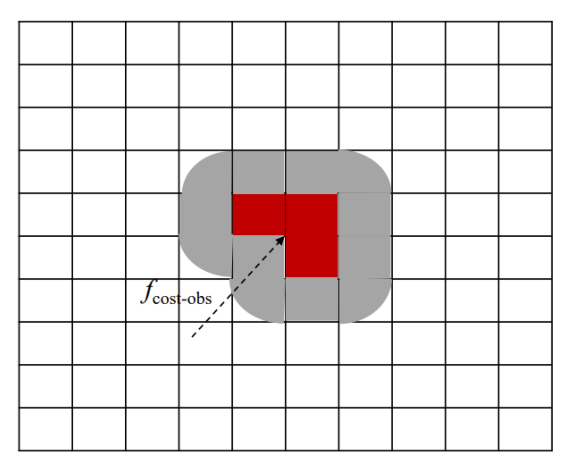
This study is based on the accuracy requirements of prediction models in two-dimensional space, a 10 × 10 n mile sea area was selected to build a grid map in the simulation experiment. Each grid is 0.25 n miles in length. At the same time, the coordinates of obstacles and ship track points are extended to grid coordinates, and set constraints on length and width for grid coordinates, as shown in Figure 4.
Static and space-time dynamic ship obstacles are the two main categories. The position of the obstacle grid is determined by the static obstacle’s coordinate points ( x ob , y ob ) , and it is then converted into a grid obstacle area based on the obstacle’s length and width. Finally, the static obstacle requires a minimal safe distance for navigation as the constraint distance from the obstacle extension. After that, the obstacle risk functions can be obtained as Equation (19):
f cost _ obs = w cost _ obs × d obs w cost _ obs = 1 π ( 1 + d obs 2 ) d obs = ( x i x ob ) 2 + ( y i y ob ) 2
A static obstacle’s influence factor is expressed by w cost _ obs , its cost function is defined by f cost _ obs , and its distance from the ship’s current trajectory point is marked by d obs . The ship’s trajectory point is defined by the coordinates ( x i , y i ) . Model search for (a) ship’s waypoints by detecting the location and condition of static barriers and applying the obstacle risk function. A space-time dynamic obstacle is the contested area that develops when ships meet, when one of the ships fails to take collision-avoidance action, or when both ships fail to react.

3. Path Planning Model Based on Conflict Search and STHA

3.1. Binary Tree Conflict Search Analysis

Conflict search and inclusion application of a binary tree are studied. Multi-ship collision avoidance process is modeled to search possible collision positions of ships to solve the problem of Multi-ship collision avoidance. A binary tree is combined with n finite components that are disjointedly distributed from the root to the left and right subtrees. A node is the name for each component of a binary tree. The ship’s mobility status at a specific time, the expense of traveling a distance, and the limitations imposed by obstacles are some of the study’s nodes.
The conflict area is searched according to the trajectory coordinates of the two ships, as shown in Figure 5. When the two ships have risk constraints, the two ships at this moment have a conflict area, and the midpoint of the coordinates of the two ships is converted into the position of the grid area, and then expanded into a space-time dynamic obstacle ( x ob _ i , y ob _ i , t i , t i + 1 ) , indicating that there is an obstacle ( x ob _ i , y ob _ i ) at the coordinate point in the period t i + 1 t i , As shown in Figure 6. The study combines conflicting nodes and time into space-time dynamic obstacles, which are then passed to the left and right subtrees. The Time-Hybrid A-star is used to re-route the conflicting ships with the lowest total cost until no conflict occurs. In order to obtain the shortest total path distance, the navigation function of multi-ship cooperative collision avoidance is as follows:
min F = i = 1 n f i f i = i = 1 n f n o d e i + 1 f n o d e i
F refers to the total cost of the multi-ship path, f i is the path cost of the i ship, and f n o d e i is the connection cost of the i node. Multi-ship collaborative simulation path is shown in Figure 7.

3.2. Space-Time Hybrid A-Star

The Space-time Hybrid A-star method was developed in this research by adding the time dimension to Hybrid A-star. The model is designed to plan a path that conforms with ship dynamics, maintains ship safety, and has a short path distance, considering the ship motion model and the cost of ship navigation.
According to the Time-Hybrid A-star algorithm, the trajectory point ( x i , y i , φ i , θ , t i ) that conforms to the ship motion model and has a short distance is selected, indicating that the ship S i is at the position ( x i , y i ) at the time t i , the heading angle is φ i , and the course to the ground is θ . Node expansion includes two heuristic expansions, obstacle expansion and non-obstruction expansion. The obstacle-free heuristic function guarantees the kinematics of the ship’s navigation, and the Euclidean distance from the initial point to the new expansion node is used as the heuristic function:
f 1 = g ( j ) g ( j ) = ( x j x i ) 2 + ( y j y i ) 2
In order to conform to COLREGs, the non-barrier node expansion function sets different weights in the selection of nodes in both left and right directions. Reference COLREGs:
Rule 9 Narrow channels
A vessel proceeding along the course of a narrow channel or fairway shall keep as near to the outer limit of the channel or fairway which lies on her starboard side as is safe and practicable.
Rule 14 Head-on situation:
When two power-driven vessels are meeting on reciprocal or nearly reciprocal courses so as to involve risk of collision each shall alter her course to starboard so that each shall pass on the port side of the other.
Rule 15 Crossing situation:
When two power-driven vessels are crossing so as to involve risk of collision, the vessel which has the other on her own starboard side shall keep out of the way and shall, if the circumstances of the case admit, avoid crossing ahead of the other vessel.
The weight of left node is 0.2 and the weight of right node is 0.8 in the process of setting up the non-obstacle function search. Since the non-obstacle node expansion function is part of the node expansion, it does not affect the search and cost control of the final objective function, and it can also meet the requirements of navigation rules of ships.
The obstacle expansion heuristic function searches for low-cost waypoints in Manhattan Distance:
f 2 = g ( n ) + h ( n )
Therefore, the nodal heuristic function is obtained as:
f c h i l d _ n o d e = w 1 f 1 + w 2 f 2
w 1 = 0.05 , w 2 = 0.95 . Combining the node heuristic function and the obstacle and constraints of ship collision avoidance behavior, the constraint function of node expansion is obtained as:
f c h i l d _ n o d e = w 1 f 1 + w 2 f 2
A Ship Path Node Search Graph is shown in Figure 8. f c h i l d _ n o d e refers to the cost of the heuristic expansion of the ship from the previous parent node to the child node, and f a r c refers to the cost of the expansion of the node caused by the ship’s flexibility.
In the process of trajectory point expansion, when there is no conflict between all trajectory points, the algorithm will stop and select the trajectory scheme with the least distance cost as the result of ship collision avoidance path.
Because the CS-STHA algorithm has a fast search mechanism, it is also effective for local path planning, and can achieve a fast response when not responding to ships. When other ships do not receive a signal or when they meet and do not take collision avoidance behavior, the ship that does not take collision avoidance behavior is set as a space-time obstacle ( o b x i , o b y i , t i ) that moves directionally with time, indicating that the obstacle at a certain moment t i The coordinate is ( o b x i , o b y i ) . Other ships take corresponding collision avoidance behaviors to the obstacles to ensure the safety of navigation.

3.3. Path Smoother

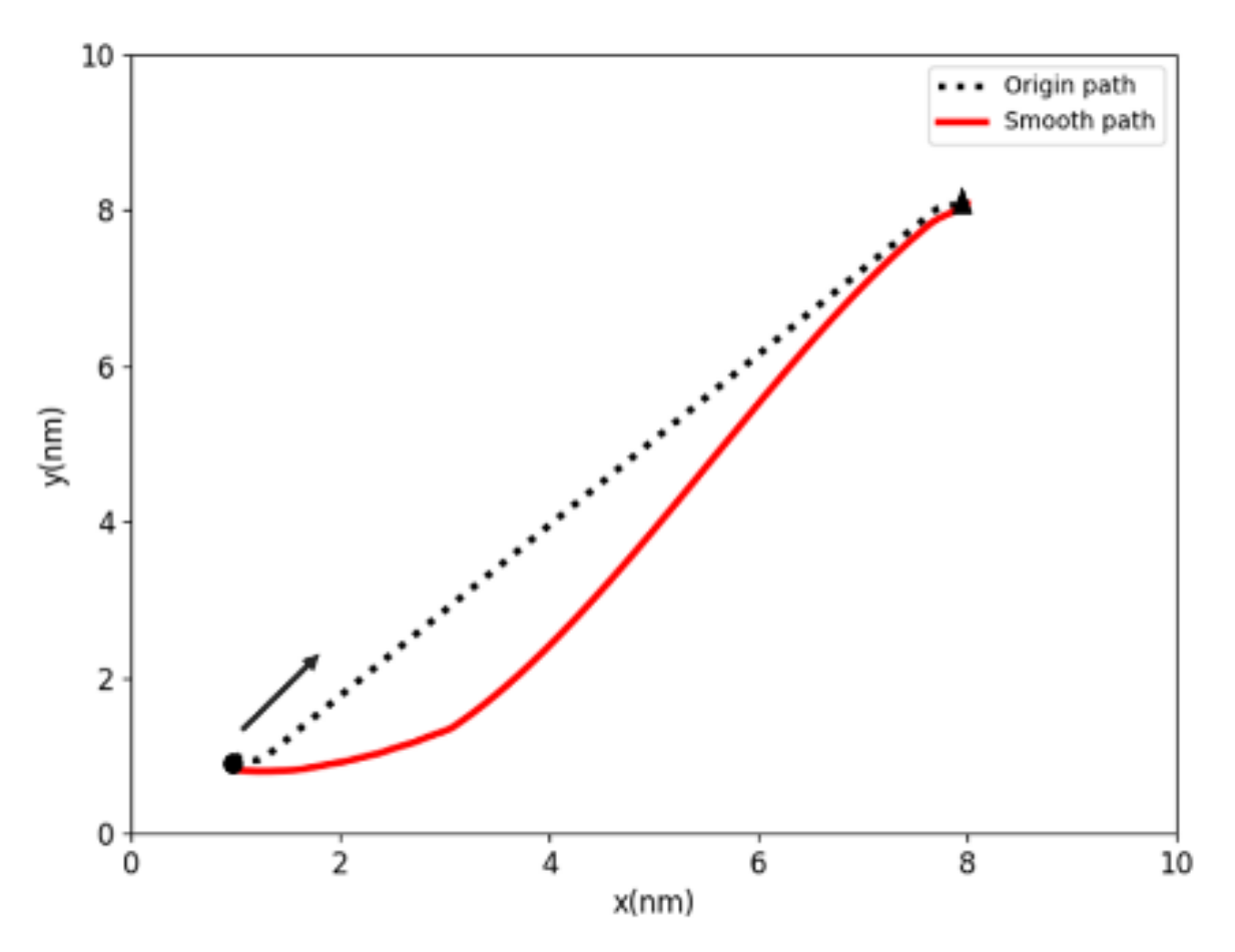
Although the shipping path based on Hybrid A* algorithm’s includes ship dynamic characteristics, it may consider factors ship sailing characteristics and shorten ship sailing distances, but it also results in numerous inflection points and uneven pathways, which do not match the needs of ocean navigation. Therefore, the path is smoothed by using cubic spline interpolation to smooth the steering angle. The following describes the cubic spline interpolation function:
q t = a 0 + a 1 t t 0 + a 2 t t 0 2 + a 3 t t 0 3 ,   t 0 t t v k = 0 , sign d k sign d k + 1 1 2 d k + d k + 1 ,   sign d k = sign d k + 1
d k = q k q k 1 / t k t k 1 , represents the derivative or “slope” of the curve, sign is the sign where a 0 , a 1 , a 2 , a 3 are the parameters to be determined. The silver-gray points represent the running route of ship 4 in the five-ship experimental simulation, while the red is the final path after optimization, indicating that the smooth degree has been improved, unnecessary control and steering actions in the path expansion node are reduced, and the quality of the solution is improved, as Figure 9 shows.

4. Simulation Analysis and Discussion

In order to prove the effectiveness of the collision avoidance path planning algorithm proposed in this paper, the research sets up 7 different types of ship encounter scenarios, from single ship to multi-ship, from two encounter scenarios to multiple scenarios mixed with each other. As the main simulation purpose of this paper is to avoid collisions with multiple ships, the experimental environment is open and calm waters with good visibility, ignoring the impact of wind and waves [30,31]. The research takes the longitude and latitude of the ship (25.77015, −80.16925) as the origin and then converts the longitude and latitude of the geodetic coordinate system into a two-dimensional plane 10 × 10 nm simulation experiment to improve the accuracy of the research. In order to verify the accuracy of a model’s parameters, the ship YUKUN is taken as the basis of the simulation [32]. In order to better assess the effectiveness of the CS-STHA algorithm, the following three cases were designed and simulated. Case 1 simulated two ships approaching head-on, crossing and overtaking. Case 2 simulated a multi-ship encounter. Case 3 simulated a real -ship encounter.

4.1. Two Ship Encounters

Ship collision risk exists in all simulation scenarios, head-on, crossing and overtaking. The information of two-ship encounters simulation are shown in Table 1. Ship’s trajectories, relative distances and (CRI) are selected to verify the effectiveness of CS-STHA. The simulation results are shown in Figure 10 and Figure 11.
Figure 10a shows that both ships adopt the collision avoidance behavior to the right, so that the ships avoid collision, the relative distance between the ships increases, and the CRI decreases as a whole based on the CS-STHA algorithm. As shown in Figure 10b,c, ship collision would take place before path planning, here relative distances is 0 and CRI is close to 1. After path planning using the coordinated CA path scheme of CS-STHA the closed relative distance between two ships increased from 0 to 1.76 nm and the peak value of the CRI decreases from 0.97 to 0.68. After the ship adopted CA action, CRI gradually reached below 0.5, which indicated that ships could pass through safety. The result in Figure 10a show that the collaborative CA path scheme not only comply with COLREGs, but also has a smooth trajectory, which meets the ship’s maneuverability requirements.
According to the COLREGs, under the crossing situation from starboard OS is the give-way ship and should take CA action, and the TS does not need to change the course and speed. The ship’s trajectory shown in Figure 11a demonstrated that only the OS adopts the collision avoidance behavior of turning right after path planning based on the CS-STHA algorithm, which is consistent with the COLREGs. As shown in Figure 11b, the minimum relative distance between ships is increased from 0 to 0.6 nm, ensuring the minimum safe distance between ships. When the OS and TS are close to each other, the ship’s CRI peaks at 0.61, and then drops in time under the influence of collision avoidance to ensure the safety between ships, as shown in Figure 11c.
In Figure 12, the path scheme based on the CS-STHA algorithm makes the OS as he give way ship and take a right turn to avoid collision, then the relative distance increased and CRI reduced. As shown in Figure 12b,c, after the OS take a right turning action, the closed relative distance between two ships reaches 0.76 nm, CRI decreased from 0.6 to 0.56 and then gradually decreased. The results show that CS-STHA algorithm not only improves the safety distance between ships, but also greatly reduces the risk of ship collision and ensures the safety of ship navigation.

4.2. Muti-Ship Situation

In order to verify the effectiveness of the cooperative collision avoidance decision based on CS-STHA algorithm, several multi-ship encounters scenarios with collision risk are designed and simulated. The details of the ships’ position and courses are shown in Table 2 and simulation results are shown in Figure 13, Figure 14, Figure 15, Figure 16, Figure 17 and Figure 18.
Figure 13 shows that when none of ships taking any actions under three-ship encounter situations, there is a collision risk between ship 1 and ship 3. At time step 80, the relative distance is 0 and at time step 100 the relative distance between ship 2 and ship 3 is 0, a collision would occurs. At time step 95, the relative distance is 0.4 nm and CRI is 0.907 between ship 1 and ship 3, and there is a great risk of collision.
As shown in Figure 14, both ship 2 and ship 3 turn right to avoid the collision, Figure 14b shows that at time step 125, the minimum relative distance is 0.762 nm, which is greater than the previous minimum distance between ships. Figure 14c shows that the cooperative path makes the peak of CRI decrease, forming a situation where the risk increases and then reduces the collision risk between ships.
As shown in Figure 15, ship 1 and ship 2 form a port crossing, ship 1 and ship 3 forms a starboard crossing, ship 3 and ship 4 form a crossing encounter. The relative distance between ships under the three types of encounters is smaller than the safety distance, and the CRI is large, there is the collision risk. Figure 16a illustrated the cooperative CA path planned based on the CS-STHA. In Figure 16b, ship 1 and ship 3 both take right turn collision avoidance behaviors, and ship 2 turns left, the relative distance between all ships increases, especially the relative distance between ship 1 and ship 3 increasing by 1 nm. All the values of CRI between ships in Figure 16c ships are smaller than those in Figure 15c at the high-risk period. It indicated that the collision risk under this multi-ship encounter situation has been effectively controlled.
Five-ship encounter situations with obvious collision risks is shown in Figure 17. Ship 2 form an overtaking, ship 1 and ship 3 form a port crossing, ship 4 and ship 5 form a starboard crossing. After the calculation of CS-STHA algorithm, ship 2 and ship 4 both take right-turn, which is compliant with COLREGs. It can be found from Figure 18b that although the path based on CS-STHA increase the average sailing distance of ships by 0.4 nm, the navigation safety of the ship is guaranteed. After planning cooperative CA path, all values of CRI between ships in Figure 18c are smaller than those without taking any CA measures in Figure 17c.

4.3. Comparative Analysis of Real Ships

In order to test the practicability of the CS-STHA in this study, an actual multi-ship encounter scene is selected, which occurred in west coast, USA. All the encounter information and characteristic parameter of ships were extracted from AIS data, including ship’s latitude and longitude, time, ship type, speed, ship length, ship width, draft, etc. Partial data of the three-ship encounter scene are shown in Table 3.
Although Ship 1 and ship 2, ship 1 and ship 3 form a starboard crossover, an objectively larger CRI indicates a risk of collision between ships, especially ship 1 and ship 3 (Figure 19). Path planning based on intelligent algorithms offers different solutions. In the path planning algorithm of CS-STHA, ship 1 adopts the collision avoidance behavior of going straight and then turning right to ensure the safety of the ship. From the point of view of ship distance, although the algorithm sacrifices the distance of about 0.76 nm, it can maintain a safe distance of more than 0.8 nm, and keep the CRI below 0.5, which better takes into account the requirements of ship navigation safety and economy. The experimental results show that the ship collision avoidance behavior based on the CS-STHA algorithm sacrifices a small distance, but can better ensure the safety of the ship, as shown in Figure 20.
From the above analysis, the CS-STHA algorithm can effectively plan multi-ship cooperative CA path and be able to keep a safety distance between ships. Furthermore, the smoothness of the path reflects the achievable trajectory of the motion control system Simulation results above show that the CS-STHA algorithm has high flexibility in complex multi-object scenarios. In addition, the collision avoidance action of ships reduces the risk between ships, which shows that the decision support method for ship collision avoidance is reliable and effective.

5. Conclusions

According to the needs of ship collision avoidance and path planning, the current research status and problems in the past are studied and analyzed, and the dynamic path planning method of CS-STHA with synergy and safety is proposed, which mainly includes the following parts:
(1)
Add a time dimension to the Hybrid A-star algorithm and transform the time dimension into a path search scheme that conforms to the ship motion model and collision avoidance rules. The heuristic function considers the path distance cost, ship maneuvering constraints, and collision avoidance between ships.
(2)
Build a ship risk constraint based on the ship’s safety distance and fuzzy collision risk and assign the risk constraints through the binary tree to construct the space-time obstacle area.
(3)
Under the condition of global path planning, set a response mechanism. If other ships do not cooperate, the ship will be set as a dynamic obstacle, and the conflict search mechanism will be used to avoid collisions with multiple ships.
(4)
Use the cubic interpolation algorithm to make the shipping path more in line with the navigation control angle and navigation rules
(5)
Use two-ship and multi-ship encounter scenarios to verify the effectiveness of CS-STHA method in multi-ship collaborative collision avoidance, and then test the applicability and flexibility of the method in combination with actual simulation cases.
According to the simulation results, the following conclusions are drawn:
(1)
According to the three typical encounter situations established by COLREGs, the paths before and after collision avoidance are compared and analyzed based on the CS-STHA algorithm. Studies have shown that the CS-STHA algorithm maximizes the safety of the ship and adopts behaviors consistent with navigational maneuvers. Although part of the sailing distance will be lost to ensure the safety of the ship, the safety is greatly improved, and the distance cost is very small.
(2)
For the multi-ship encounter, the study designs three-ship, four-ship, and five-ship cases based on actual sailing cases, and analyzes the path cost and safety of the CS-STHA algorithm in the multi-ship encounter. Under the fuzzy ship collision risk calculation, the CS-STHA method can effectively ensure the safety of ships and make the minimum safety distance between ships within an acceptable safety range. At the same time, the multi-ship cooperative collision avoidance path scheme with the shortest total path distance is obtained.
(3)
To ensure the feasibility of ship simulation, this paper designs an actual ship encounter scheme based on the actual sailing case and compares the actual sailing and CS-STHA methods. The research shows that CS-STHA consumes less path cost, and the research in this paper is more in line with the actual navigation requirements.
(4)
The collision risk assessment in this paper adopts the ship domain model, and the distance between ships cannot be lower than the minimum safe distance between ships. Therefore, the optimal paths for all ships and other target ships are constrained by the ship’s safety distance.
(5)
The CS-STHA algorithm in this paper ensures the steering angle and turning radius constraints of the ship’s flexibility, improves the relative distance of the ship and the navigation safety of the ship, and reduces the risk of ship collision. Because the ship’s motion has the characteristics of large inertia, large time delay, nonlinear, and so on. Therefore, it is very necessary to consider the flexibility of the ship in the decision-making scheme of ship collision avoidance. CS-STHA uses the Hybrid A* algorithm to increase the search range of navigation points and uses the Dobbins curve model and ship motion model to derive the turning radius and navigation angle, narrowing the gap between collision avoidance algorithms or decision-making systems and practical applications, taking into account the flexibility of the ship. The effectiveness of the method is verified by the calculation of actual navigation cases.
The CS-STHA algorithm can effectively solve the problem of autonomous collision avoidance in different encounter scenarios. However, compared with other research results, this paper also has certain advantages and problems. This paper proposes a collaborative collision avoidance algorithm for ships based on conflict search, which considers COLREG rules, ship safety and ship flexibility. Furthermore, few studies consider the areas of ships. In this paper, the safety distance between ships is calculated based on various factors such as ship area, collision risk, and navigation, and the dynamic obstacles in the space-time dimension. They are used to ensure the cooperative avoidance between ships. This paper not only enables the ship to dynamically adapt to the risky area, but also obtains a collaborative path that conforms to the collision avoidance rules. Finally, for the path obtained by the CS-STHA method, the method of cubic interpolation is used to make the path of the ship smoother. In addition, the method can also solve the problem of autonomous collision avoidance in real time when encountering multiple objects, complex situations, and uncoordinated or temporary actions of other ships. Although the established CS-STHA has been proved to be reasonable, effective, and feasible, there are still the following problems: the stability of the marine environment is roughly assumed, and there is no modeling of wind, wave and other factors. In addition, due to the lack of experimental conditions and no physical experimental results to verify, further research will be further studied in the future.

Author Contributions

Conceptualization, J.Y. and L.G.; Methodology, J.Y.; Software, J.Y.; Validation, J.Y. and L.G.; Formal Analysis, J.Y.; Investigation, J.Y.; Resources, J.Y.; Data Management, J.Y.; Writing—Manuscript Preparation, J.Y.; Writing—Reviews and Editors, J.Y.; Visualization, J.Y.; Supervision, L.G.; Project Management, L.G.; Funding Acquisition: L.G. All authors have read and agreed to the published version of the manuscript.

Funding

This research was supported by the National Natural Science Foundation of China (grants no. 52171345) and the 2022 First-class Discipline Seed Fund of Navigation College, DMU.

Institutional Review Board Statement

Not applicable.

Informed Consent Statement

Not applicable.

Acknowledgments

We are especially grateful to Marine Intelligent Transportation Research Team and technical support.

Conflicts of Interest

The authors declare no conflict of interest.

References

  1. Tam, C.; Bucknall, R.; Greig, A. Review of Collision Avoidance and Path Planning Methods for Ships in Close Range Encounters. J. Navig. 2009, 62, 455–476. [Google Scholar] [CrossRef]
  2. Lazarowska, A.; Żak, A. A Concept of Autonomous Multi-Agent Navigation System for Unmanned Surface Vessels. Electronics 2022, 11, 2853. [Google Scholar] [CrossRef]
  3. Zhang, K.; Huang, L.; Liu, X.; Chen, J.; Zhao, X.; Huang, W.; He, Y. A Novel Decision Support Methodology for Autonomous Collision Avoidance Based on Deduction of Manoeuvring Process. J. Mar. Sci. Eng. 2022, 10, 765. [Google Scholar] [CrossRef]
  4. Lee, H.; Motes, J.; Morales, M.; Amato, N. Parallel Hierarchical Composition Conflict-Based Search for Optimal Multi-Agent Pathfinding. IEEE Robot. Autom. Lett. 2021, 6, 7001–7008. [Google Scholar] [CrossRef]
  5. Krishnamurthy, P.; Khorrami, F.; Ng, T.L. Obstacle Avoidance for Unmanned Sea Surface Vehicles: A Hierarchical Approach. IFAC Proc. Vol. 2008, 41, 6798–6803. [Google Scholar] [CrossRef] [Green Version]
  6. Wang, X.; Yao, X.; Zhang, L. Path Planning under Constraints and Path Following Control of Autonomous Underwater Vehicle with Dynamical Uncertainties and Wave Disturbances. J. Intell. Robot. Syst. 2020, 99, 891–908. [Google Scholar] [CrossRef]
  7. Tian, Y.; Huang, L.; Xiong, Y.; Li, S. On the velocity obstacle based automatic collision avoidance with multiple target ships at sea. In Proceedings of the 2015 International Conference on Transportation Information and Safety (ICTIS), Wuhan, China, 25–28 June 2015; pp. 468–472. [Google Scholar]
  8. Benjamin, M.R.; Curcio, J.A. COLREGS-based navigation of autonomous marine vehicles. In Proceedings of the IEEE/OES Autonomous Underwater Vehicles (IEEE Cat. No. 04CH37578), Sebasco, ME, USA, 17–18 June 2004; pp. 32–39. [Google Scholar]
  9. Naeem, W.; Irwin, G.W. An Automatic Collision Avoidance Strategy for Unmanned Surface Vehicles; Springer: Berlin/Heidelberg, Germany, 2010; pp. 184–191. ISBN 1865-0929. [Google Scholar]
  10. Yao, X.; Wang, X.; Wang, F.; Zhang, L. Path Following Based on Waypoints and Real-Time Obstacle Avoidance Control of an Autonomous Underwater Vehicle. Sensors 2020, 20, 795. [Google Scholar] [CrossRef] [PubMed] [Green Version]
  11. Zhai, P.; Zhang, Y.; Shaobo, W. Intelligent Ship Collision Avoidance Algorithm Based on DDQN with Prioritized Experience Replay under COLREGs. J. Mar. Sci. Eng. 2022, 10, 585. [Google Scholar] [CrossRef]
  12. Pietrzykowski, Z.; Wołejsza, P.; Nozdrzykowski, Ł.; Borkowski, P.; Banaś, P.; Magaj, J.; Chomski, J.; Mąka, M.; Mielniczuk, S.; Pańka, A.; et al. The autonomous navigation system of a sea-going vessel. Ocean Eng. 2022, 261, 112104. [Google Scholar] [CrossRef]
  13. Lazarowska, A. Method of considering the dynamics of a ship in the process of determining a safe trajectory using an algorithm based on Ant Colony Optimization. In Proceedings of the 2016 21st International Conference on Methods and Models in Automation and Robotics (MMAR), Miedzyzdroje, Poland, 29 August–1 September 2016; pp. 625–629. [Google Scholar] [CrossRef]
  14. Lisowski, J. Synthesis of a Path-Planning Algorithm for Autonomous Robots Moving in a Game Environment during Collision Avoidance. Electronics 2021, 10, 675. [Google Scholar] [CrossRef]
  15. Wang, H.; Fu, Z.; Zhou, J.; Fu, M.; Ruan, L. Cooperative collision avoidance for unmanned surface vehicles based on improved genetic algorithm. Ocean Eng. 2021, 222, 108612. [Google Scholar] [CrossRef]
  16. Liu, F. Research on Ship Path Planning Method Based on Deep Reinforcement Learning. Ph.D. Thesis, Wuhan University of Technology China, Wuhan, China, 2020. [Google Scholar]
  17. Chen, C.; Ma, F.; Xu, X.; Chen, Y.; Wang, J. A Novel Ship Collision Avoidance Awareness Approach for Cooperating Ships Using Multi-Agent Deep Reinforcement Learning. J. Mar. Sci. Eng. 2021, 9, 1056. [Google Scholar] [CrossRef]
  18. Ahmed, Y.A.; Hannan, M.A.; Oraby, M.Y.; Maimun, A. COLREGs Compliant Fuzzy-Based Collision Avoidance System for Multiple Ship Encounters. J. Mar. Sci. Eng. 2021, 9, 790. [Google Scholar] [CrossRef]
  19. Aguiar, A.P.; Hespanha, J.P. Trajectory-Tracking and Path-Following of Underactuated Autonomous Vehicles with Parametric Modeling Uncertainty. IEEE Trans. Autom. Control 2007, 8, 1362–1379. [Google Scholar] [CrossRef] [Green Version]
  20. Kang, Y.; Chen, W.; Zhu, D.; Wang, J. Collision avoidance path planning in multi-ship encounter situations. J. Mar. Sci. Tech.—Jpn. 2021, 26, 1026–1037. [Google Scholar] [CrossRef]
  21. Song, R.; Liu, Y.; Bucknall, R. Smoothed A algorithm for practical unmanned surface vehicle path planning. Appl. Ocean Res. 2019, 83, 9–20. [Google Scholar] [CrossRef]
  22. Miao, T.; Amam, E.E.; Slaets, P.; Pissoort, D. An improved real-time collision-avoidance algorithm based on Hybrid A* in a multi-object-encountering scenario for autonomous surface vessels. Ocean Eng. 2022, 255, 111406. [Google Scholar] [CrossRef]
  23. Li, J.; Felner, A.; Boyarski, E.; Ma, H.; Koenig, S. Improved Heuristics for Multi-Agent Path Finding with Conflict-Based Search. In Proceedings of the Twenty-Eighth International Joint Conference on Artificial Intelligence (IJCAI-19), Macao, China, 10–16 August 2019. [Google Scholar]
  24. Codesseira, V.C.; Tannuri, E.A. Path Following Control for Autonomous Ship using Model Predictive Control. IFAC-PapersOnLine 2021, 54, 57–62. [Google Scholar] [CrossRef]
  25. Quy, N.M.; Bazuga, K.; Gucma, L.; Vrijling, J.K.; van Gelder, P.H.A.J. Towards generalized ship’s manoeuvre models based on real time simulation results in port approach areas. Ocean Eng. 2020, 209, 107476. [Google Scholar] [CrossRef]
  26. Qiu, Z.; Lan, P. A Synthetic Decision System for Ship Collision Avoidance. Navig. China 1992, 2, 48–56. [Google Scholar] [CrossRef]
  27. Abebe, M.; Noh, Y.; Seo, C.; Kim, D.; Lee, I. Developing a Ship Collision Risk Index estimation model based on Dempster-Shafer theory. Appl. Ocean Res. 2021, 113, 102735. [Google Scholar] [CrossRef]
  28. Xu, W.; Hu, J.Q.; Yin, J.C.; Li, K. Composite evaluation of ship collision risk index based on fuzzy theory. Ship Sci. Technol.—China 2018, 40, 52–56. [Google Scholar] [CrossRef]
  29. Wang, X. Motion Control and Path Planning Research for Underactuated Autonomous Underwater Vehicle. Ph.D. Thesis, Harbin Engineering University, Harbin, China, 2020. [Google Scholar]
  30. Gao, Q.; Song, L.; Yao, J. RANS Prediction of Wave-Induced Ship Motions, and Steady Wave Forces and Moments in Regular Waves. J. Mar. Sci. Eng. 2021, 9, 1459. [Google Scholar] [CrossRef]
  31. Borkowski, P. Numerical Modeling of Wave Disturbances in the Process of Ship Movement Control. Algorithms 2018, 11, 130. [Google Scholar] [CrossRef] [Green Version]
  32. Liu, J.; Zhao, B.; Li, L. Collision Avoidance for Underactuated Ocean-Going Vessels Considering COLREGs Constraints. IEEE Access 2021, 9, 145943–145954. [Google Scholar] [CrossRef]
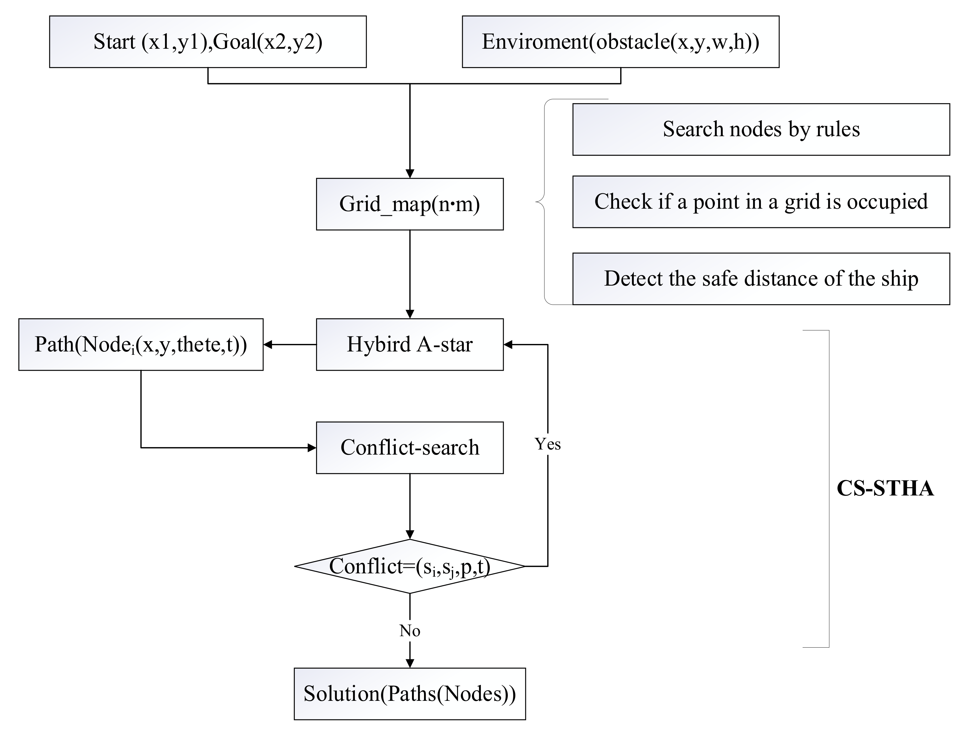
Figure 1. Algorithmic flowchart of multi-ship collaborative collision avoidance path.
Jmse 10 01504 g001
Figure 2. The maximum collision avoidance angle of the ship.
Jmse 10 01504 g002
Figure 3. Ship Dubins curve model.
Jmse 10 01504 g003
Figure 4. Obstacle expansion map.
Jmse 10 01504 g004
Figure 5. Ship conflict node search graph.
Jmse 10 01504 g005
Figure 6. Space-time dynamic obstacles.
Jmse 10 01504 g006
Figure 7. Multi-ship collaborative simulation path.
Jmse 10 01504 g007
Figure 8. Ship path node search graph.
Jmse 10 01504 g008
Figure 9. Path smoothing diagram.
Jmse 10 01504 g009
Figure 10. The result of the head-on encounter between the two ships. (a) trajectories; (b) relative distance; (c) CRI.
Jmse 10 01504 g010
Figure 11. The result of the crossing encounter between the two ships. (a) trajectories; (b) relative distance; (c) CRI.
Jmse 10 01504 g011
Figure 12. The result of the overtaking encounter between the two ships. (a) trajectories; (b) relative distance; (c) CRI.
Jmse 10 01504 g012
Figure 13. The result of three-ship encounter without measures. (a) trajectories; (b) relative distance; (c) CRI.
Jmse 10 01504 g013
Figure 14. The CA result of three-ship encounter based on CS-STHA. (a) trajectories; (b) relative distance; (c) CRI.
Jmse 10 01504 g014
Figure 15. The result of four-ship encounter without measures. (a) trajectories; (b) relative distance; (c) CRI.
Jmse 10 01504 g015
Figure 16. The CA result of four-ship encounter based on CS-STHA. (a) trajectories; (b) relative distance; (c) CRI.
Jmse 10 01504 g016
Figure 17. The result of five-ship encounter without measures. (a) trajectories; (b) relative distance; (c) CRI.
Jmse 10 01504 g017
Figure 18. The result of five-ship encounter based on CS-STHA. (a) trajectories; (b) relative distance; (c) CRI.
Jmse 10 01504 g018
Figure 19. Three-ship encounter comparison.
Jmse 10 01504 g019
Figure 20. Comparison between actual ship relative distance and CRI simulation. (a) relative distance of real ships; (b) relative distance of CS-STHA; (c) CRI of real ships; (d) CRI of CS-STHA.
Jmse 10 01504 g020
Table 1. Typical two-ship encounter data.
CaseShip ListStart-PositionCourse (°)Goal-Position
overtakingOS(25.81938672190124, −80.15101723193693)90(25.85212101688134, −80.0051096817491)
TS(25.85212101688134, −80.0051096817491)270(25.85212101688134, −80.0051096817491)
CrossingOS(25.901449816529674, −80.15100458314197)45(25.78648996276379, −80.02342829513535)
TS(25.786561484048686, −80.15102227956486)315(25.901378126712103, −80.0232867241675)
Head-onOS(25.797386913628763, −80.1207598367107)90(25.901358781858733, −80.00504133260878)
TS(25.80953821635524, −80.1446378084954)75(25.848339881095615, −79.99964375266372)
Table 2. Complex ship encounter data.
CaseShip ListStart-PositionCourse (°)Goal-Position
Three-shipShip1(25.81938672190124, −80.15101723193693)90(25.85212101688134, −80.0051096817491)
Ship2(25.884946193546583, −80.00506413096967)270(25.802974102975046, −80.15101975659907)
Ship3(25.78648996276379, −80.02342829513535)315(25.901449816529674, −80.15100458314197)
Four-shipShip1(25.802974102975046, −80.15101975659907)45(25.901378126712103, −80.0232867241675)
Ship2(25.78656006497455, −80.14190841956533)60(25.917807796255882, −80.04151437734187)
Ship3(25.81108954597314, −80.00516653418576)300(25.901448394111643, −80.14188187493257)
Ship4(25.78648996276379, −80.02342829513535)0(25.917787033376307, −80.01961685956509)
Five-shipShip1(25.786561484048686, −80.15102227956486)45(25.901378126712103, −80.0232867241675)
Ship2(25.80296923107549, −80.12732044132656)60(25.906346289032157, −80.07801912836804)
Ship3(25.868624078324324, −80.1473615773753)180(25.85212101688134, −80.0051096817491)
Ship4(25.885028097190915, −80.11452135171605)160(25.866892346387452, −80.00508919147534)
Ship5(25.917822594366235, −80.0597623142908)180(25.794725282277557, −80.0562303404331)
Table 3. Data of real ship under three-ship encounter situation.
CaseShip ListStart-PositionCourse (°)Goal-Position
RealShip1(25.802970696052224, −80.13278951389665)90(25.901395195706737, −80.04153212134828)
Ship2(25.88996098328195, −80.15100635653317)90(25.880011895778633, −79.99594992040794)
Ship3(25.860418269215984, −80.1510109128528)45(25.868533605220787, −80.00508691401308)
Publisher’s Note: MDPI stays neutral with regard to jurisdictional claims in published maps and institutional affiliations.