
Combining UAV-Based Multispectral and Thermal Images to Diagnosing Dryness Under Different Crop Areas on the Loess Plateau

 , and
, and
Abstract
:1. Introduction
2. Materials and Methods
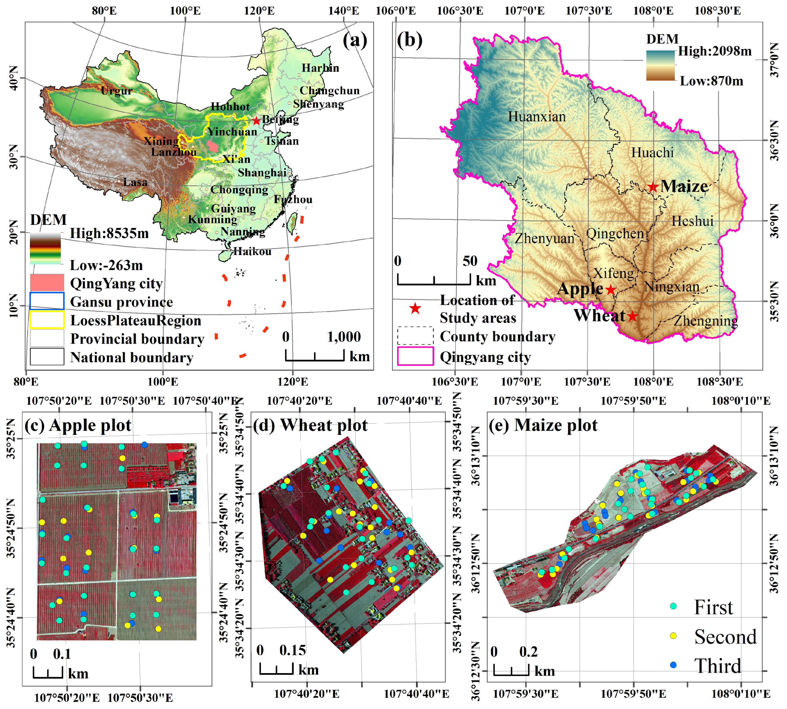
2.1. Study Areas
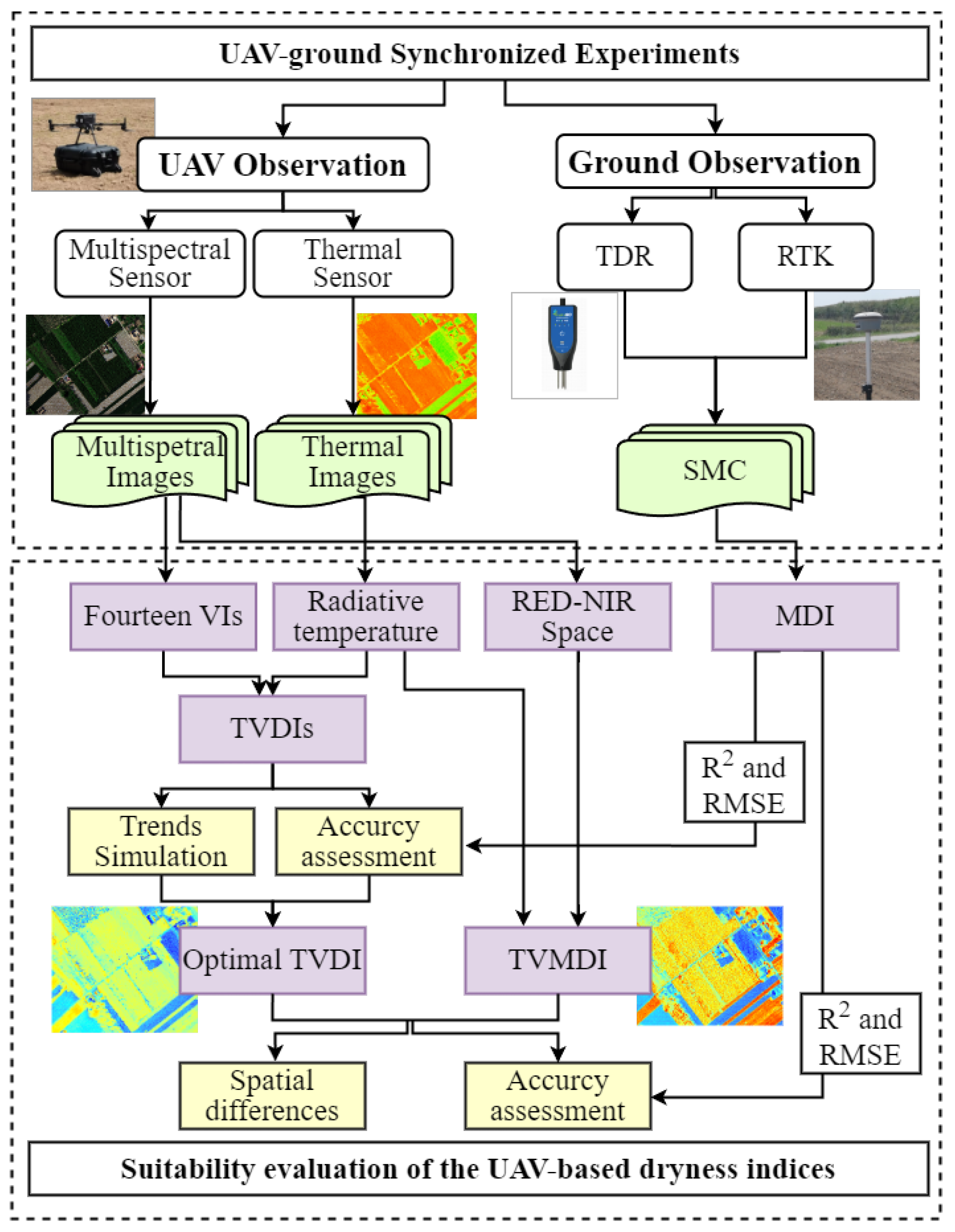
2.2. Overall Workflow
2.3. Experiment Step and Data Acquisition
2.3.1. UAV Observation and Image Pre-Processing
2.3.2. Synchronous Observation and Measurement of Soil Moisture
2.4. Remote Sensing Drought Index Retrieval and Analysis
2.4.1. TVDI
2.4.2. TVMDI
2.4.3. GSSIM
2.4.4. Impact Factor Analysis
3. Results
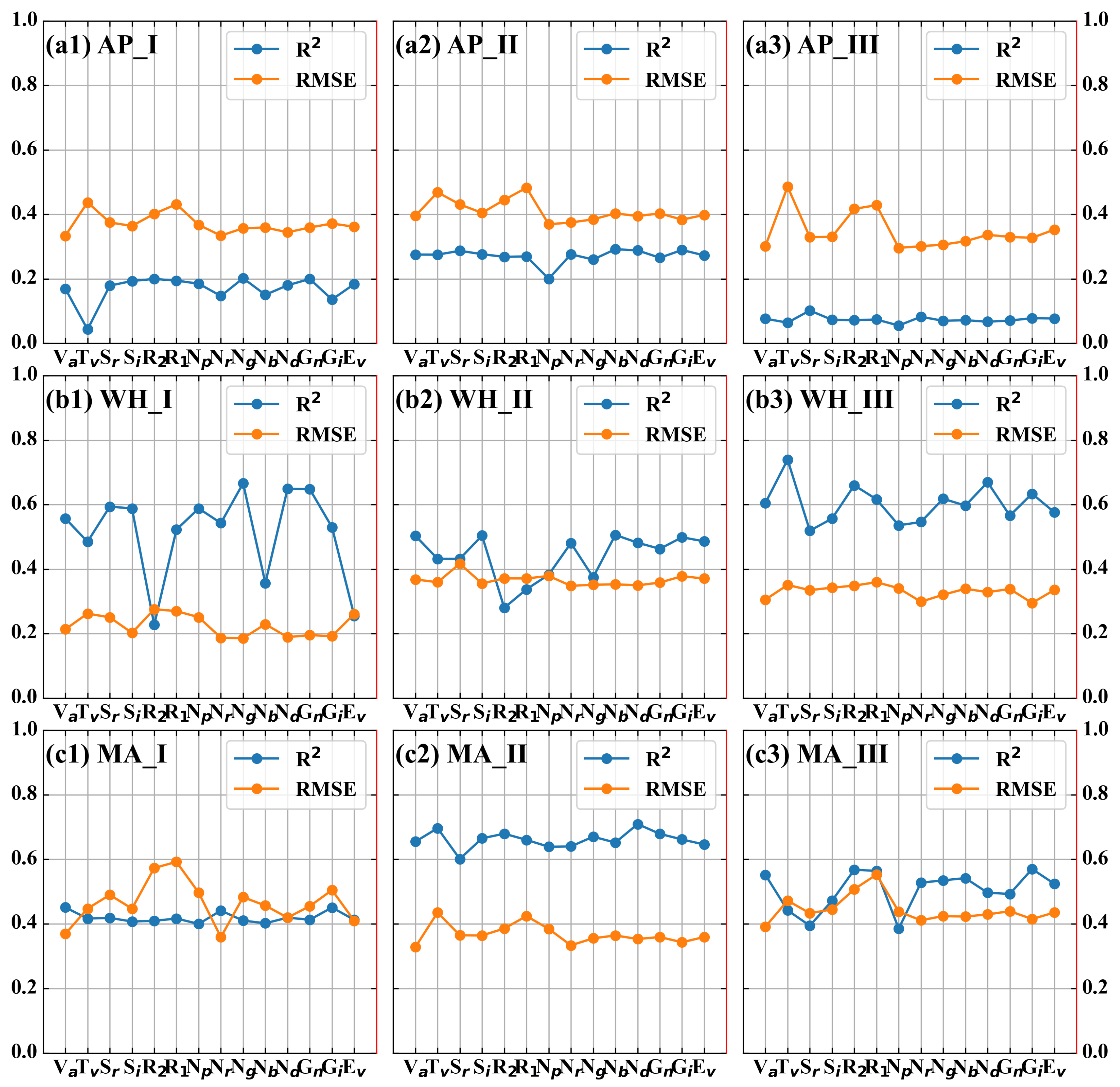
3.1. Comparison of Different VI-Based TVDIs
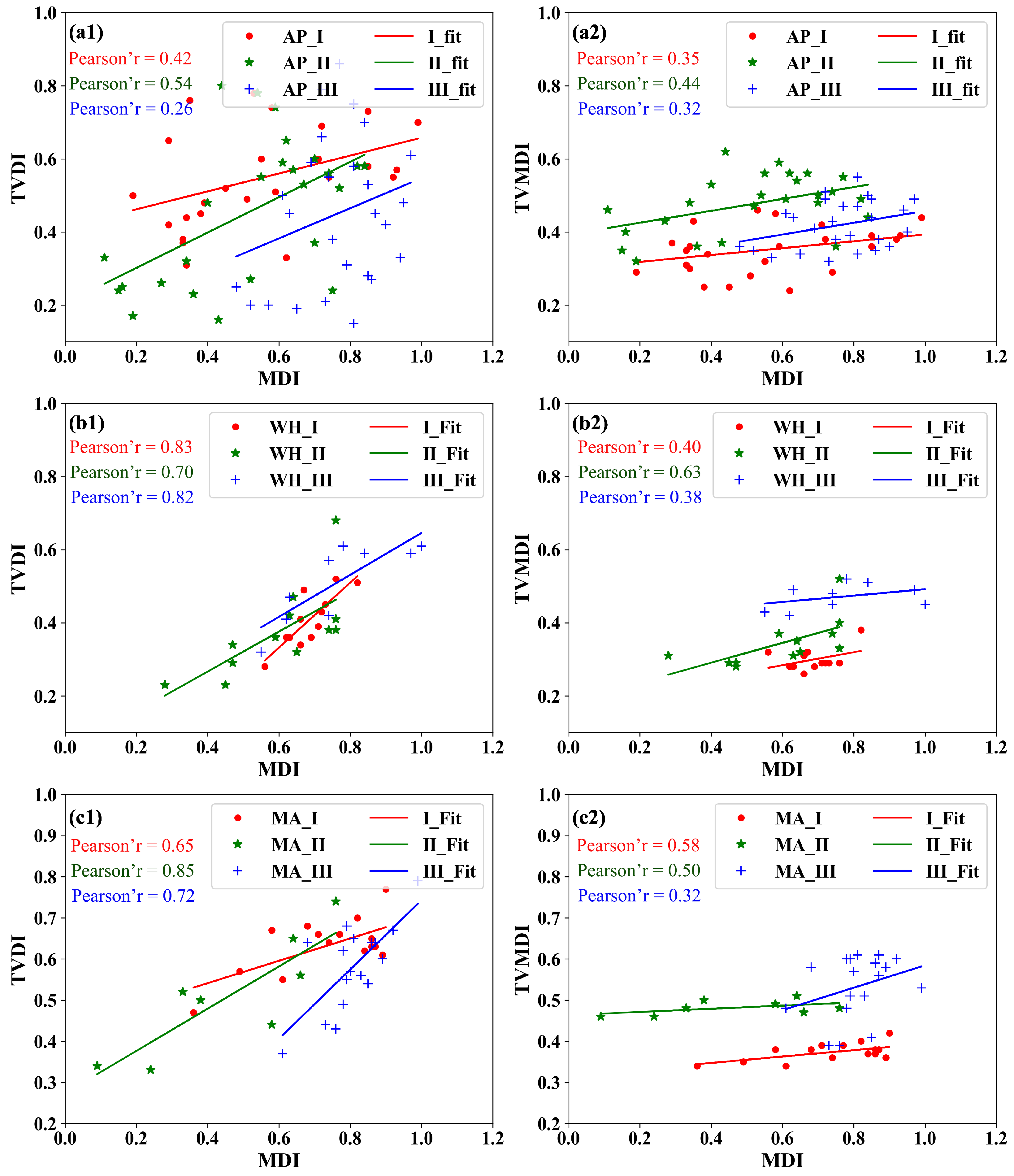
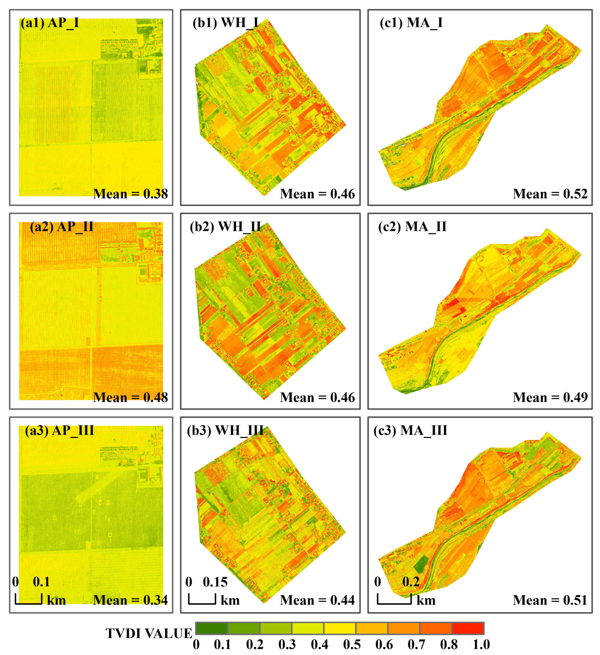
3.2. Estimation Accuracy of TVDI and TVMDI
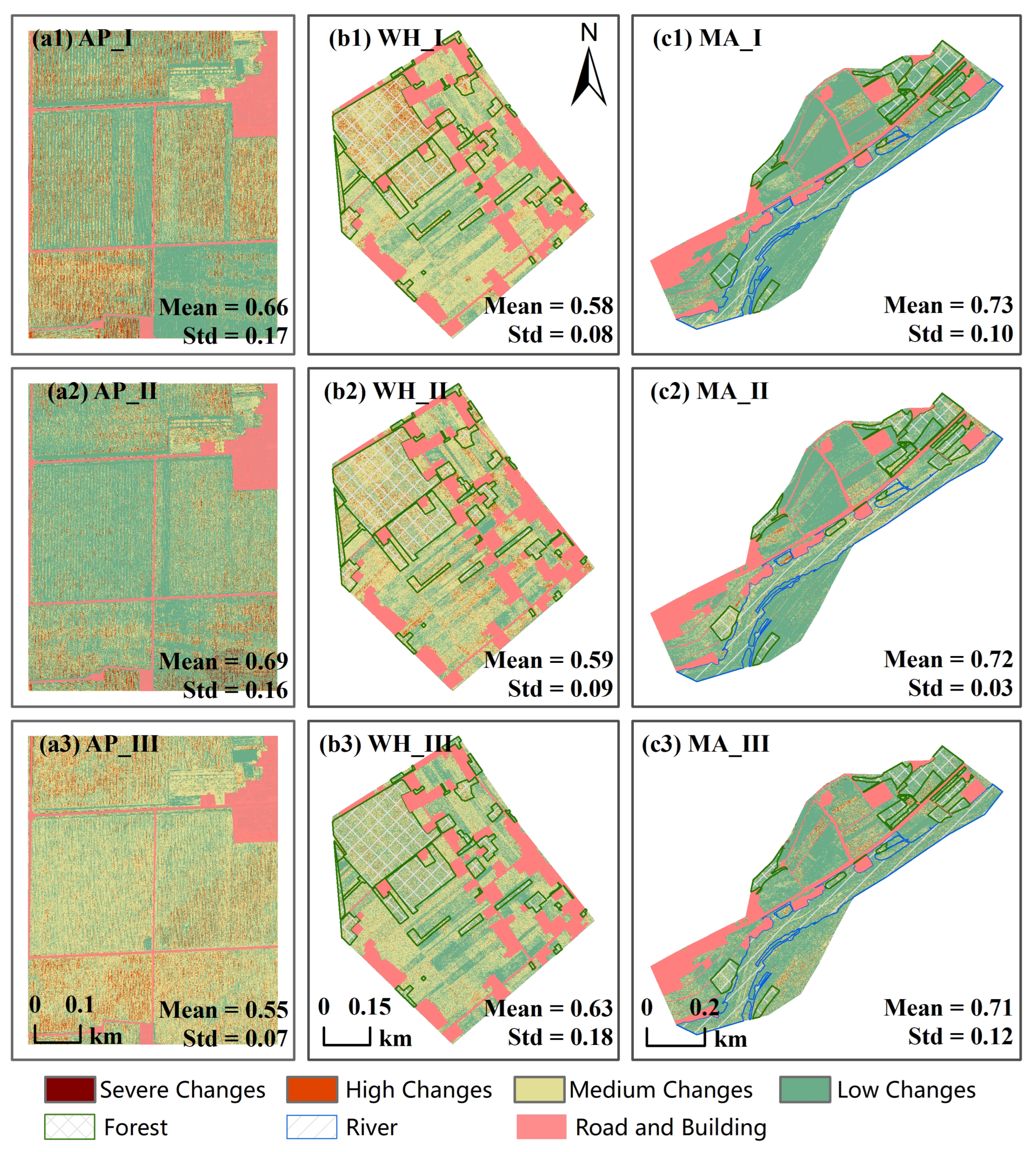
3.3. Spatial Differences Between TVDI and TVMDI Based on GSSIM
4. Discussion
4.1. Trend Analysis of TVDI Simulated by Different VIs
4.2. Performance of TVDI in Monitoring Drought
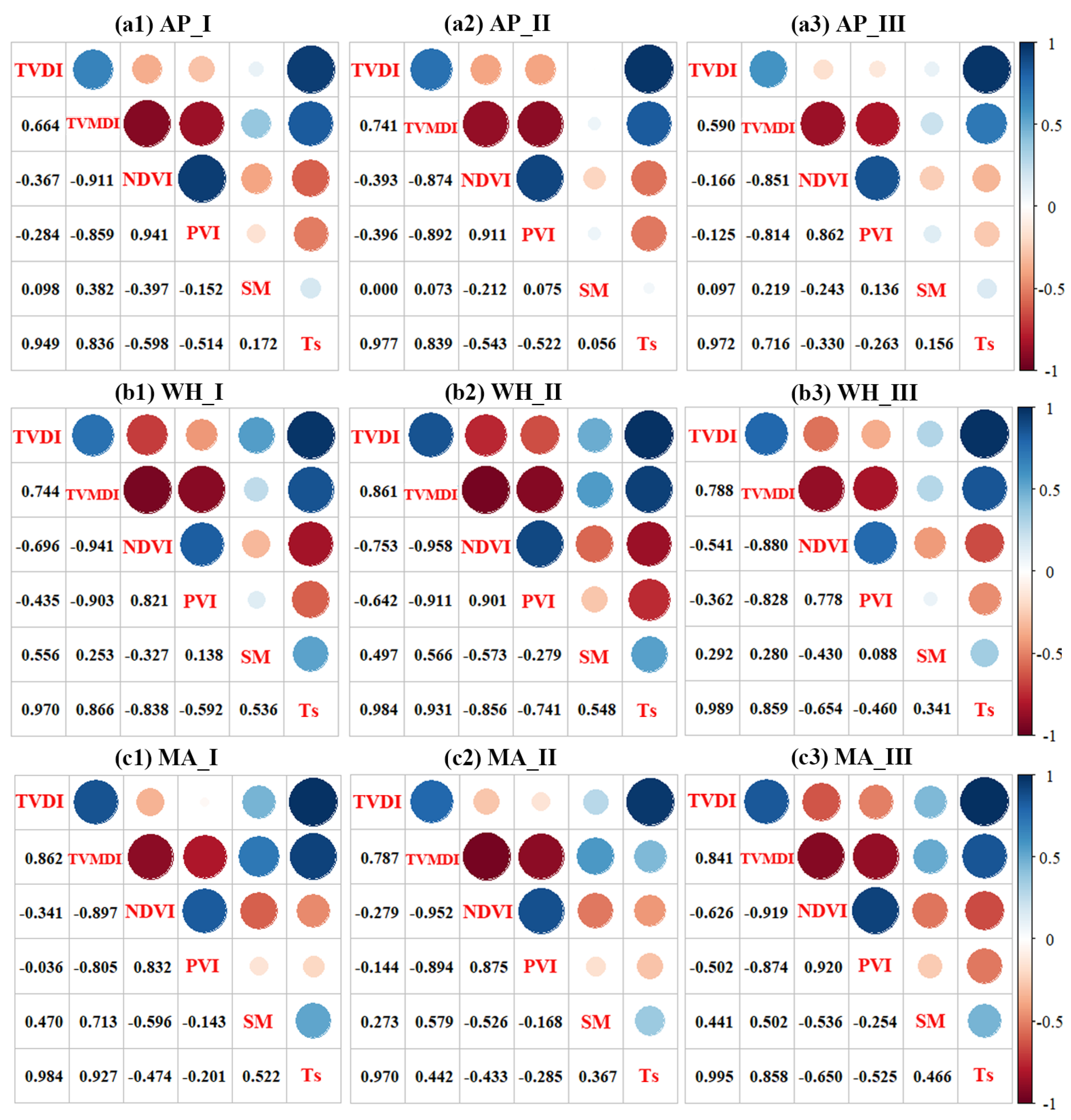
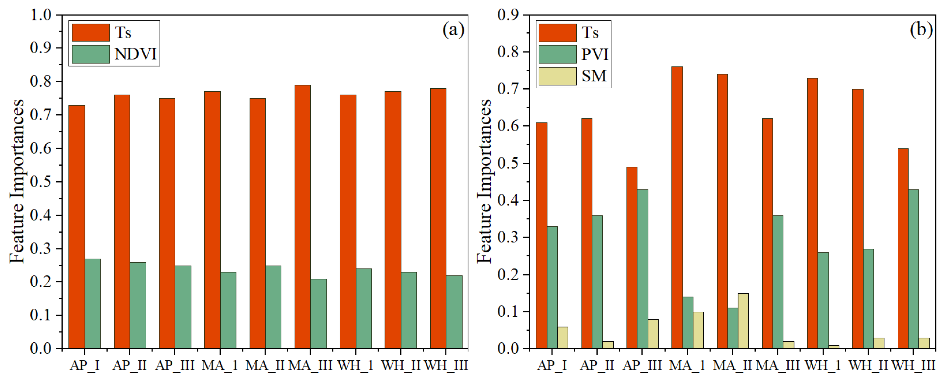
4.3. Impact Factor Between TVDI and TVMDI
5. Conclusions
Author Contributions
Funding
Institutional Review Board Statement
Data Availability Statement
Conflicts of Interest
References
- Amani, M.; Salehi, B.; Mahdavi, S.; Masjedi, A.; Dehnavi, S. Temperature-Vegetation-soil Moisture Dryness Index (TVMDI). Remote Sens. Environ. 2017, 197, 1–14. [Google Scholar] [CrossRef]
- Hao, L.; Zhang, X.; Liu, S. Risk assessment to China’s agricultural drought disaster in county unit. Nat. Hazards 2011, 61, 785–801. [Google Scholar] [CrossRef]
- Jin, N.; Shi, Y.; Niu, W.H.; He, L. Spatial and temporal patterns of agricultural drought in China during 1960–2020 characterized by use of the crop water deficit Abnormal Index. J. Hydrol. 2023, 627, 130454. [Google Scholar] [CrossRef]
- Han, Z.M.; Huang, Q.; Huang, S.Z.; Leng, G.Y.; Bai, Q.J.; Liang, H.; Wang, L.; Zhao, J.; Fang, W. Spatial-temporal dynamics of agricultural drought in the Loess Plateau under a changing environment: Characteristics and potential influencing factors. Agric. Water Manag. 2021, 244, 106540. [Google Scholar] [CrossRef]
- Wu, J.W.; Miao, C.Y.; Tang, X.; Duan, Q.Y.; He, X.J. A nonparametric standardized runoff index for characterizing hydrological drought on the Loess Plateau, China. Glob. Planet. Chang. 2018, 161, 53–65. [Google Scholar] [CrossRef]
- Wang, D.; Yue, D.X.; Zhou, Y.Y.; Huo, F.B.; Bao, Q.; Li, K. Drought Resistance of Vegetation and Its Change Characteristics before and after the Implementation of the Grain for Green Program on the Loess Plateau, China. Remote Sens. 2022, 14, 5142. [Google Scholar] [CrossRef]
- Zhang, G.X.; Zhang, Y.; Zhao, D.H.; Liu, S.J.; Wen, X.X.; Han, J.; Liao, Y.C. Quantifying the impacts of agricultural management practices on the water use efficiency for sustainable production in the Loess Plateau region: A meta-analysis. Field Crop. Res. 2023, 291, 108787. [Google Scholar] [CrossRef]
- Salunke, R.; Nobahar, M.; Alzeghoul, O.E.; Khan, S.; La Cour, I.; Amini, F. Near-Surface Soil Moisture Characterization in Mississippi’s Highway Slopes Using Machine Learning Methods and UAV-Captured Infrared and Optical Images. Remote Sens. 2023, 15, 1888. [Google Scholar] [CrossRef]
- Cheng, M.H.; Jiao, X.Y.; Liu, Y.D.; Shao, M.C.; Yu, X.; Bai, Y.; Wang, Z.X.; Wang, S.Y.; Tuohuti, N.; Liu, S.B.; et al. Estimation of soil moisture content under high maize canopy coverage from UAV multimodal data and machine learning. Agric. Water Manag. 2022, 264, 107530. [Google Scholar] [CrossRef]
- Wu, S.R.; Ren, J.Q.; Chen, Z.X.; Yang, P.; Li, H. Soil moisture estimation based on the microwave scattering mechanism during different crop phenological periods in a winter wheat-producing region. J. Hydrol. 2020, 590, 125521. [Google Scholar] [CrossRef]
- Sadeghi, M.; Babaeian, E.; Tuller, M.; Jones, S.B. The optical trapezoid model: A novel approach to remote sensing of soil moisture applied to Sentinel-2 and Landsat-8 observations. Remote Sens. Environ. 2017, 198, 52–68. [Google Scholar] [CrossRef]
- Wang, Q.; Li, J.C.; Jin, T.Y.; Chang, X.; Zhu, Y.C.; Li, Y.W.; Sun, J.J.; Li, D.W. Comparative Analysis of Landsat-8, Sentinel-2, and GF-1 Data for Retrieving Soil Moisture over Wheat Farmlands. Remote Sens. 2020, 12, 2708. [Google Scholar] [CrossRef]
- Fang, W.; Huang, S.Z.; Huang, Q.; Huang, G.H.; Wang, H.; Leng, G.Y.; Wang, L.; Guo, Y. Probabilistic assessment of remote sensing-based terrestrial vegetation vulnerability to drought stress of the Loess Plateau in China. Remote Sens. Environ. 2019, 232, 111290. [Google Scholar] [CrossRef]
- Khose, S.B.; Mailapalli, D.R. Spatial mapping of soil moisture content using very-high resolution UAV-based multispectral image analytics. Smart Agric. Technol. 2024, 8, 100467. [Google Scholar] [CrossRef]
- Das, S.; Christopher, J.; Roy Choudhury, M.; Apan, A.; Chapman, S.; Menzies, N.W.; Dang, Y.P. Evaluation of drought tolerance of wheat genotypes in rain-fed sodic soil environments using high-resolution UAV remote sensing techniques. Biosyst. Eng. 2022, 217, 68–82. [Google Scholar] [CrossRef]
- Li, J.T.; Schachtman, D.P.; Creech, C.F.; Wang, L.; Ge, Y.F.; Shi, Y.Y. Evaluation of UAV-derived multimodal remote sensing data for biomass prediction and drought tolerance assessment in bioenergy sorghum. Crop J. 2022, 10, 1363–1375. [Google Scholar] [CrossRef]
- D’Odorico, P.; Schönbeck, L.; Vitali, V.; Meusburger, K.; Schaub, M.; Ginzler, C.; Zweifel, R.; Velasco, V.M.E.; Gisler, J.; Gessler, A.; et al. Drone-based physiological index reveals long-term acclimation and drought stress responses in trees. Plant Cell Environ. 2021, 44, 3552–3570. [Google Scholar] [CrossRef]
- Zhou, J.; Zhou, J.; Ye, H.; Ali, M.L.; Nguyen, H.T.; Chen, P. Classification of soybean leaf wilting due to drought stress using UAV-based imagery. Comput. Electron. Agric. 2020, 175, 105576. [Google Scholar] [CrossRef]
- Song, L.; Ding, Z.; Kustas, W.P.; Xu, Y.; Zhao, G.; Liu, S.; Ma, M.; Xue, K.; Bai, Y.; Xu, Z. Applications of a thermal-based two-source energy balance model coupled to surface soil moisture. Remote Sens. Environ. 2022, 271, 112923. [Google Scholar] [CrossRef]
- Xu, Y.; Song, L.; Kustas, W.P.; Xue, K.; Liu, S.; Ma, M.; Xu, T.; Zhao, L. Application of the two-source energy balance model with microwave-derived soil moisture in a semi-arid agricultural region. Int. J. Appl. Earth Obs. Geoinf. 2022, 112, 102879. [Google Scholar] [CrossRef]
- Kimura, R. Estimation of moisture availability over the Liudaogou river basin of the Loess Plateau using new indices with surface temperature. J. Arid. Environ. 2007, 70, 237–252. [Google Scholar] [CrossRef]
- Koley, S.; Jeganathan, C. Estimation and evaluation of high spatial resolution surface soil moisture using multi-sensor multi-resolution approach. Geoderma 2020, 378, 114618. [Google Scholar] [CrossRef]
- Deng, H.; Cheng, F.; Wang, J.; Wang, C. Monitoring of drought in central Yunnan, China based on TVDI model. Pol. J. Environ. Stud. 2021, 30, 3511–3523. [Google Scholar] [CrossRef]
- Pang, S.F.; Wei, W.; Guo, Z.C.; Zhang, J.; Xie, B.B. Agricultural drought characteristics and its influencing factors in gansu province based on TVDI. Chin. J. Ecol. 2019, 38, 1849–1860. [Google Scholar]
- Fitriyah, A.; Fatikhunnada, A.; Okura, F.; Nugroho, B.D.A.; Kato, T. Analysis of the drought mitigated mechanism in terraced paddy fields using CWSI and TVDI indices and hydrological monitoring. Sustainability 2019, 11, 6897. [Google Scholar] [CrossRef]
- Du, L.T.; Song, N.P.; Liu, K.; Hou, J.; Hu, Y.; Zhu, Y.; Wang, X.Y.; Wang, L.; Guo, Y.G. Comparison of two simulation methods of the Temperature Vegetation Dryness Index (TVDI) for drought monitoring in semi-arid regions of China. Remote Sens. 2017, 9, 177. [Google Scholar] [CrossRef]
- Bai, J.J.; Yu, Y.; Di, L.P. Comparison between TVDI and CWSI for drought monitoring in the Guanzhong Plain, China. J. Integr. Agric. 2017, 16, 389–397. [Google Scholar] [CrossRef]
- Cheng, M.H.; Sun, C.M.; Nie, C.W.; Liu, S.B.; Yu, X.; Bai, Y.; Liu, Y.D.; Meng, L.; Jia, X.; Liu, Y.; et al. Evaluation of UAV-based drought indices for crop water conditions monitoring: A case study of summer maize. Agric. Water Manag. 2023, 287, 108442. [Google Scholar] [CrossRef]
- Zhang, Y.; Liu, X.H.; Jiao, W.Z.; Zhao, L.J.; Zeng, X.M.; Xing, X.Y.; Zhang, L.N.; Hong, Y.X.; Lu, Q.Q. A new multi-variable integrated framework for identifying flash drought in the Loess Plateau and Qinling Mountains regions of China. Agric. Water Manag. 2022, 265, 107544. [Google Scholar] [CrossRef]
- Wang, S.; An, J.; Zhao, X.; Gao, X.; Wu, P.; Huo, G.; Robinson, B.H. Age- and climate- related water use patterns of apple trees on China’s Loess Plateau. J. Hydrol. 2020, 582, 124462. [Google Scholar] [CrossRef]
- Zhou, Z.W.; Zhang, T.F.; Zhang, M.C.; Liu, Y.; Xue, J.X.; Zhang, J.L. Study on Analysis of the Climate Change Characteristics in Qingyang over the Past 50 Years. Gansu Agric. Sci. Technol. 2022, 53, 45–51. (In Chinese) [Google Scholar]
- Sandholt, I.; Rasmussen, K.; Andersen, J. A simple interpretation of the surface temperature/vegetation index space for assessment of surface moisture status. Remote Sens. Environ. 2002, 79, 213–224. [Google Scholar] [CrossRef]
- Wigmore, O.; Mark, B.; McKenzie, J.; Baraer, M.; Lautz, L. Sub-metre mapping of surface soil moisture in proglacial valleys of the tropical Andes using a multispectral unmanned aerial vehicle. Remote Sens. Environ. 2019, 222, 104–118. [Google Scholar] [CrossRef]
- Gitelson, A.A.; Kaufman, Y.J.; Stark, R.; Rundquist, D. Novel algorithms for remote estimation of vegetation fraction. Remote Sens. Environ. 2002, 80, 76–87. [Google Scholar] [CrossRef]
- Ranjan, R.; Chopra, U.K.; Sahoo, R.N.; Singh, A.K.; Pradhan, S. Assessment of plant nitrogen stress in wheat (Triticum aestivum L.) through hyperspectral indices. Int. J. Remote Sens. 2012, 33, 6342–6360. [Google Scholar] [CrossRef]
- Song, X.X.; Wu, F.; Lu, X.T.; Yang, T.L.; Ju, C.X.; Sun, C.M.; Liu, T. The Classification of Farming Progress in Rice–Wheat Rotation Fields Based on UAV RGB Images and the Regional Mean Model. Agriculture 2022, 12, 124. [Google Scholar] [CrossRef]
- Song, B.; Park, K. Detection of aquatic plants using multispectral UAV imagery and vegetation index. Remote Sens. 2020, 12, 387. [Google Scholar] [CrossRef]
- Penuelas, J.; Frederic, B.; Filella, I. Semi-Empirical Indices to Assess Carotenoids/Chlorophyll-a Ratio from Leaf Spectral Reflectance. Photosynthetica 1995, 31, 221–230. [Google Scholar]
- Zarco-Tejada, P.J.; Berjón, A.; López-Lozano, R.; Miller, J.R.; Martín, P.; Cachorro, V.; González, M.R.; De Frutos, A. Assessing vineyard condition with hyperspectral indices: Leaf and canopy reflectance simulation in a row-structured discontinuous canopy. Remote Sens. Environ. 2005, 99, 271–287. [Google Scholar] [CrossRef]
- Townshend, J.R.G.; Goff, T.E.; Tucker, C.J. Multitemporal Dimensionality of Images of Normalized Difference Vegetation Index at Continental Scales. IEEE Trans. Geosci. Remote Sens. 1985, GE-23, 888–895. [Google Scholar] [CrossRef]
- Wang, F.M.; Huang, J.F.; Tang, Y.L.; Wang, X.Z. New Vegetation Index and Its Application in Estimating Leaf Area Index of Rice. Rice Sci. 2007, 14, 195–203. [Google Scholar] [CrossRef]
- Huete, A.; Didan, K.; Miura, T.; Rodriguez, E.P.; Gao, X.; Ferreira, L.G. Overview of the radiometric and biophysical performance of the MODIS vegetation indices. Remote Sens. Environ. 2002, 83, 195–213. [Google Scholar] [CrossRef]
- Mishra, S.; Mishra, D.R. Normalized difference chlorophyll index: A novel model for remote estimation of chlorophyll-a concentration in turbid productive waters. Remote Sens. Environ. 2012, 117, 394–406. [Google Scholar] [CrossRef]
- Xue, L.H.; Cao, W.X.; Luo, W.H.; Dai, T.B.; Zhu, Y. Monitoring Leaf Nitrogen Status in Rice with Canopy Spectral Reflectance. Agron. J. 2004, 96, 135–142. [Google Scholar] [CrossRef]
- Liu, K.; Li, Y.Z.; Han, T.F.; Yu, X.C.; Ye, H.C.; Hu, H.W.; Hu, Z.H. Evaluation of grain yield based on digital images of rice canopy. Plant Methods 2019, 15, 28. [Google Scholar] [CrossRef]
- Broge, N.H.; Leblanc, E. Comparing prediction power and stability of broadband and hyperspectral vegetation indices for estimation of green leaf area index and canopy chlorophyll density. Remote Sens. Environ. 2001, 76, 156–172. [Google Scholar] [CrossRef]
- Amani, M.; Parsian, S.; Mirmazloumi, S.M.; Aieneh, O. Two new soil moisture indices based on the NIR-red triangle space of Landsat-8 data. Int. J. Appl. Earth Obs. Geoinf. 2016, 50, 176–186. [Google Scholar] [CrossRef]
- Liu, Y.; Yue, H. The Temperature Vegetation Dryness Index (TVDI) Based on Bi-Parabolic NDVI-Ts Space and Gradient-Based Structural Similarity (GSSIM) for Long-Term Drought Assessment Across Shaanxi Province, China (2000–2016). Remote Sens. 2018, 10, 959. [Google Scholar] [CrossRef]
- Yue, H.; Liu, Y.; Qian, J.X. Comparative assessment of drought monitoring index susceptibility using geospatial techniques. Environ. Sci. Pollut. Res. 2021, 28, 38880–38900. [Google Scholar] [CrossRef] [PubMed]
- Breiman, L. Random Forests. Mach. Learn. 2001, 45, 5–32. [Google Scholar] [CrossRef]
- Zhang, D.J.; Zhou, G.Q. Estimation of Soil Moisture from Optical and Thermal Remote Sensing: A Review. Sensors 2016, 16, 1308. [Google Scholar] [CrossRef]
- Bindlish, R.; Jackson, T.J.; Gasiewski, A.; Stankov, B.; Klein, M.; Cosh, M.H.; Mladenova, I.; Watts, C.; Vivoni, E.; Lakshmi, V.; et al. Aircraft based soil moisture retrievals under mixed vegetation and topographic conditions. Remote Sens. Environ. 2008, 112, 375–390. [Google Scholar] [CrossRef]
- Garcia-Garcia, D.; Rosa, X.R.L.; Bedoya, D.G.; Schrevens, E. Linear mixed model analysis of NDVI-based canopy coverage, extracted from sequential UAV multispectral imagery of an open field tomato irrigation experiment. Comput. Electron. Agric. 2021, 189, 106399. [Google Scholar] [CrossRef]
- Jiang, R.; Sanchez-Azofeifa, A.; Laakso, K.; Wang, P.; Xu, Y.; Zhou, Z.Y.; Luo, X.W.; Lan, Y.B.; Zhao, G.P.; Chen, X. UAV-based partially sampling system for rapid NDVI mapping in the evaluation of rice nitrogen use efficiency. J. Clean Prod. 2021, 289, 125705. [Google Scholar] [CrossRef]
- Qiao, L.; Tang, W.J.; Gao, D.H.; Zhao, R.M.; An, L.L.; Li, M.Z.; Sun, H.; Song, D. UAV-based chlorophyll content estimation by evaluating vegetation index responses under different crop coverages. Comput. Electron. Agric. 2022, 196, 106775. [Google Scholar] [CrossRef]
- Li, S.Y.; Yuan, F.; Ata-Ui-Karim, S.T.; Zheng, H.B.; Cheng, T.; Liu, X.J.; Tian, Y.C.; Zhu, Y.; Cao, W.X.; Cao, Q. Combining Color Indices and Textures of UAV-Based Digital Imagery for Rice LAI Estimation. Remote Sens. 2019, 11, 1763. [Google Scholar] [CrossRef]
- Xu, M.; Yao, N.; Hu, A.; de Goncalves, L.G.G.; Mantovani, F.A.; Horton, R.; Heng, L.; Liu, G. Evaluating a new temperature-vegetation-shortwave infrared reflectance dryness index (TVSDI) in the continental United States. J. Hydrol. 2022, 610, 127785. [Google Scholar] [CrossRef]
- Li, C.; Adu, B.; Wu, J.; Qin, G.; Li, H.; Han, Y. Spatial and temporal variations of drought in Sichuan Province from 2001 to 2020 based on modified temperature vegetation dryness index (TVDI). Ecol. Indic. 2022, 139, 108883. [Google Scholar] [CrossRef]
- Gao, Y.; Lian, X.; Ge, L. Inversion model of surface bare soil temperature and water content based on UAV thermal infrared remote sensing. Infrared Phys. Technol. 2022, 125, 104289. [Google Scholar] [CrossRef]
- Jia, Q.; Shi, H.; Li, R.; Miao, Q.; Feng, Y.; Wang, N.; Li, J. Evaporation of maize crop under mulch film and soil covered drip irrigation: Field assessment and modelling on West Liaohe Plain, China. Agric. Water Manag. 2021, 253, 106894. [Google Scholar] [CrossRef]
- Huang, G.B.; Chen, W.; Li, F.R. Rainfed Farming Systems in the Loess Plateau of China. In Rainfed Farming Systems; Copper, I., Partridge, I., Birch, C., Eds.; Springer: Dordrecht, The Netherlands, 2011; pp. 643–669. [Google Scholar]
- Hu, X.; Ren, H.; Tansey, K.; Zheng, Y.; Ghent, D.; Liu, X.; Yan, L. Agricultural drought monitoring using European Space Agency Sentinel 3A land surface temperature and normalized difference vegetation index imageries. Agric. For. Meteorol. 2019, 279, 107707. [Google Scholar] [CrossRef]
- Gu, H.B.; Lin, Z.; Guo, W.X.; Deb, S. Retrieving Surface Soil Water Content Using a Soil Texture Adjusted Vegetation Index and Unmanned Aerial System Images. Remote Sens. 2021, 13, 145. [Google Scholar] [CrossRef]


| Time | Major Crop Growth Period |
|---|---|
| 2 May 2022 to 3 May 2022 (the first experiment) | Wheat Heading Period, WHP |
| Maize Sowing Period, MAP | |
| Apple Blooming Period, ABP | |
| 17 May 2022 to 19 May 2022 (the second experiment) | Wheat Filling Period, WFP |
| Maize Emergence Period, MEP | |
| Apple Fruit Setting Period, ASP | |
| 14 June 2022 to 17 June 2022 (the third experiment) | Wheat Ripe Period, WRP |
| Maize Jointing Period, MJP | |
| Apple Fruit Development Period, ADP |
| Vegetable Index | Formulation | Reference |
|---|---|---|
| Visible Atmospherically Resistant Index (VARI) | [34] | |
| Normalized Pigment Chlorophyll Index (NPCI) | [35] | |
| The Normalized Green–Blue Difference Index (NGBDI) | [36] | |
| Normalized Green–Red Difference Index (NGRDI) | [37] | |
| Simple Ratio Pigment Index (SRPI) | [38] | |
| Green Index (GI) | [39] | |
| Normalized Difference Vegetation Index (NDVI) | [40] | |
| Structure Insensitive Pigment Index (SIPI) | [38] | |
| Green Normalized Difference Vegetation Index (GNDVI) | [41] | |
| Enhanced Vegetation Index (EVI) | [42] | |
| Ratio Vegetation Index (RVI) | [43] | |
| Ratio Vegetation Index 2 (RVI2) | [44] | |
| Normalized Greenness Intensity (NGI) | [45] | |
| Triangular Vegetation Index (TVI) | [46] |
| Plot | Experiment | TVDI vs. MDI | TVMDI vs. MDI | ||||||
|---|---|---|---|---|---|---|---|---|---|
| Period | Fit | Pearson’s r | p | RMSE | Fit | Pearson’s r | p | RMSE | |
| AP | I | 0.42 | 0.036 | 0.21 | 0.35 | 0.091 | 0.29 | ||
| AP | II | 0.54 | 0.005 | 0.21 | 0.44 | 0.026 | 0.2 | ||
| AP | III | 0.26 | 0.198 | 0.38 | 0.32 | 0.113 | 0.36 | ||
| WH | I | 0.83 | 0.001 | 0.28 | 0.4 | 0.203 | 0.39 | ||
| WH | II | 0.7 | 0.011 | 0.25 | 0.63 | 0.029 | 0.28 | ||
| WH | III | 0.82 | 0.006 | 0.27 | 0.38 | 0.31 | 0.32 | ||
| MA | I | 0.65 | 0.007 | 0.16 | 0.58 | 0.018 | 0.39 | ||
| MA | II | 0.85 | 0.008 | 0.14 | 0.5 | 0.209 | 0.21 | ||
| MA | III | 0.72 | 0.001 | 0.24 | 0.32 | 0.202 | 0.29 | ||
Disclaimer/Publisher’s Note: The statements, opinions and data contained in all publications are solely those of the individual author(s) and contributor(s) and not of MDPI and/or the editor(s). MDPI and/or the editor(s) disclaim responsibility for any injury to people or property resulting from any ideas, methods, instructions or products referred to in the content. |
© 2025 by the authors. Licensee MDPI, Basel, Switzerland. This article is an open access article distributed under the terms and conditions of the Creative Commons Attribution (CC BY) license (https://creativecommons.org/licenses/by/4.0/).
Share and Cite
Zhang, J.; Qi, Y.; Li, Q.; Zhang, J.; Yang, R.; Wang, H.; Li, X. Combining UAV-Based Multispectral and Thermal Images to Diagnosing Dryness Under Different Crop Areas on the Loess Plateau. Agriculture 2025, 15, 126. https://doi.org/10.3390/agriculture15020126
Zhang J, Qi Y, Li Q, Zhang J, Yang R, Wang H, Li X. Combining UAV-Based Multispectral and Thermal Images to Diagnosing Dryness Under Different Crop Areas on the Loess Plateau. Agriculture. 2025; 15(2):126. https://doi.org/10.3390/agriculture15020126
Chicago/Turabian StyleZhang, Juan, Yuan Qi, Qian Li, Jinlong Zhang, Rui Yang, Hongwei Wang, and Xiangfeng Li. 2025. "Combining UAV-Based Multispectral and Thermal Images to Diagnosing Dryness Under Different Crop Areas on the Loess Plateau" Agriculture 15, no. 2: 126. https://doi.org/10.3390/agriculture15020126
APA StyleZhang, J., Qi, Y., Li, Q., Zhang, J., Yang, R., Wang, H., & Li, X. (2025). Combining UAV-Based Multispectral and Thermal Images to Diagnosing Dryness Under Different Crop Areas on the Loess Plateau. Agriculture, 15(2), 126. https://doi.org/10.3390/agriculture15020126