
Spatial Layout of Cotton Seed Production Based on Hierarchical Classification: A Case Study in Xinjiang, China

 ,
,
Abstract
:1. Introduction
2. Materials and Methods
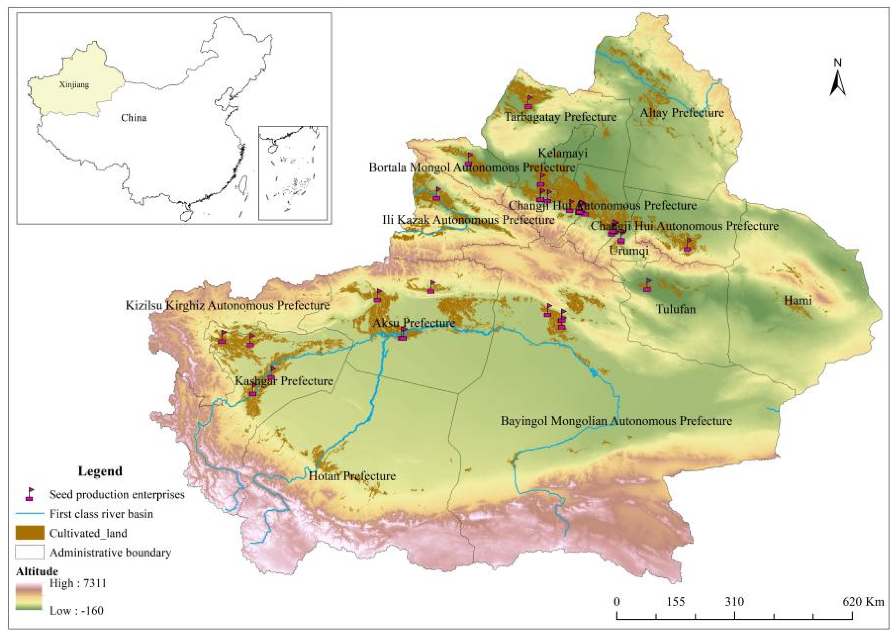
2.1. Study Area
2.2. Data Collection and Processing
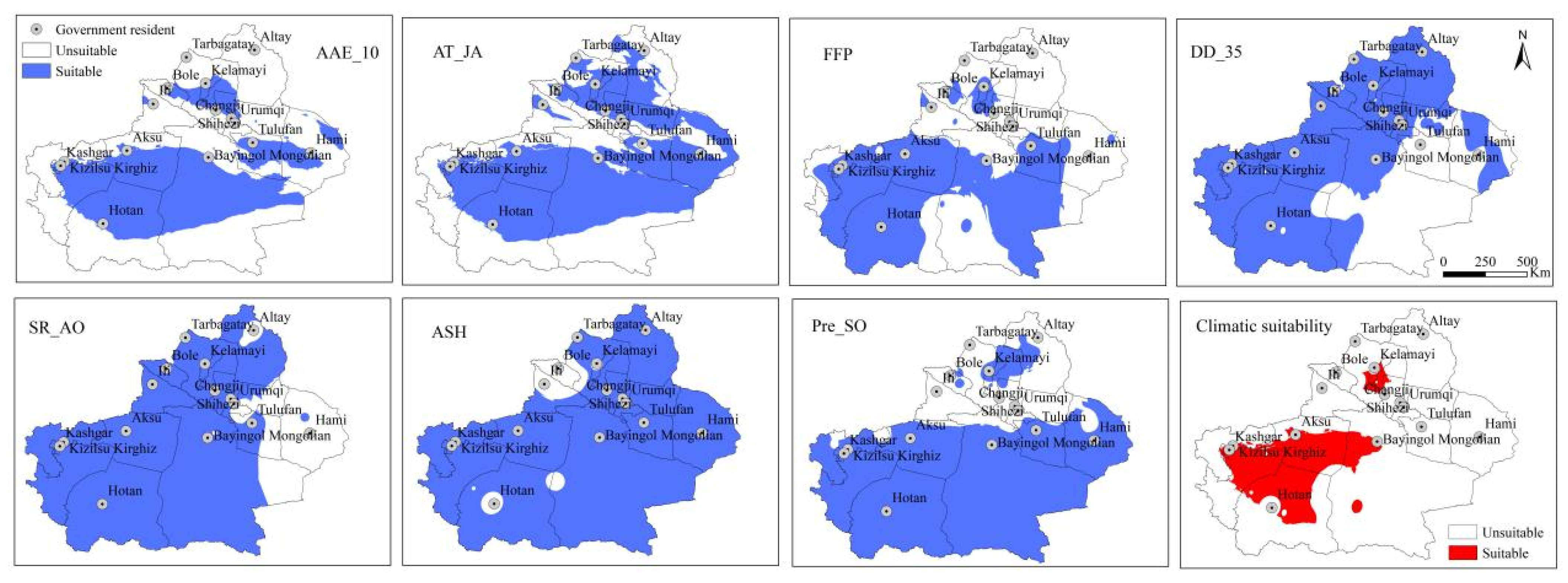
2.2.1. Meteorological Data
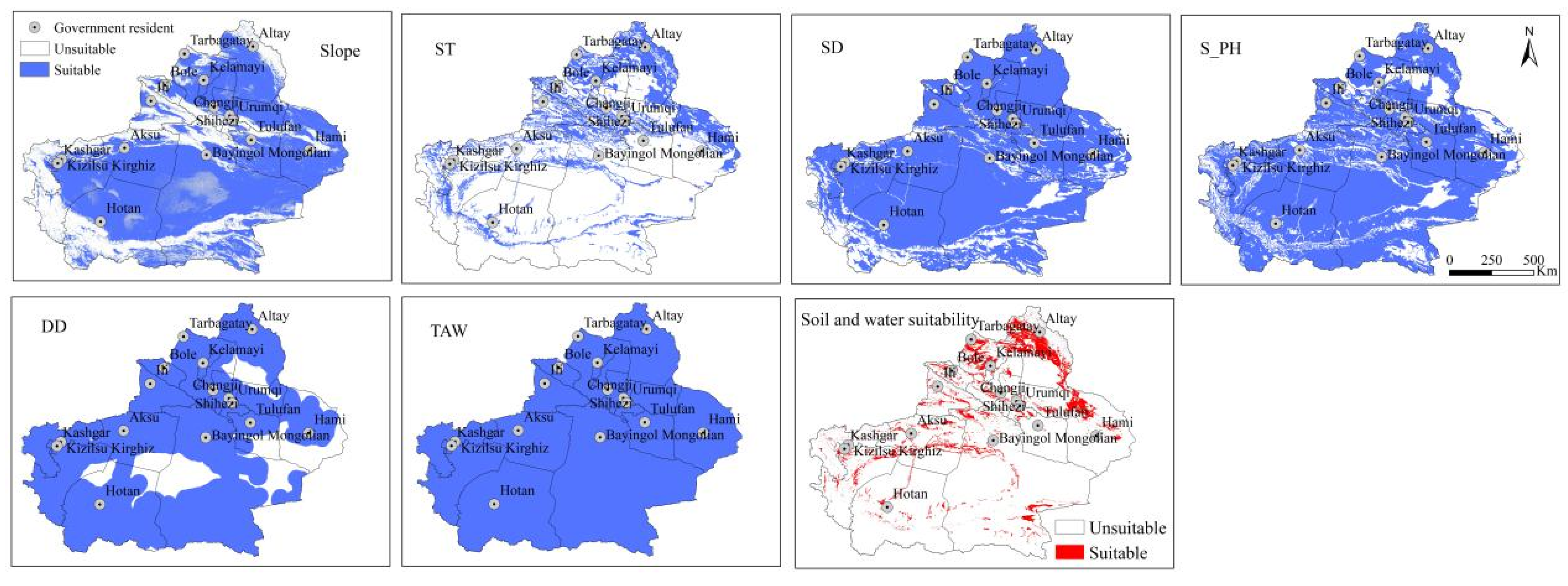
2.2.2. Soil and Water Resource Data
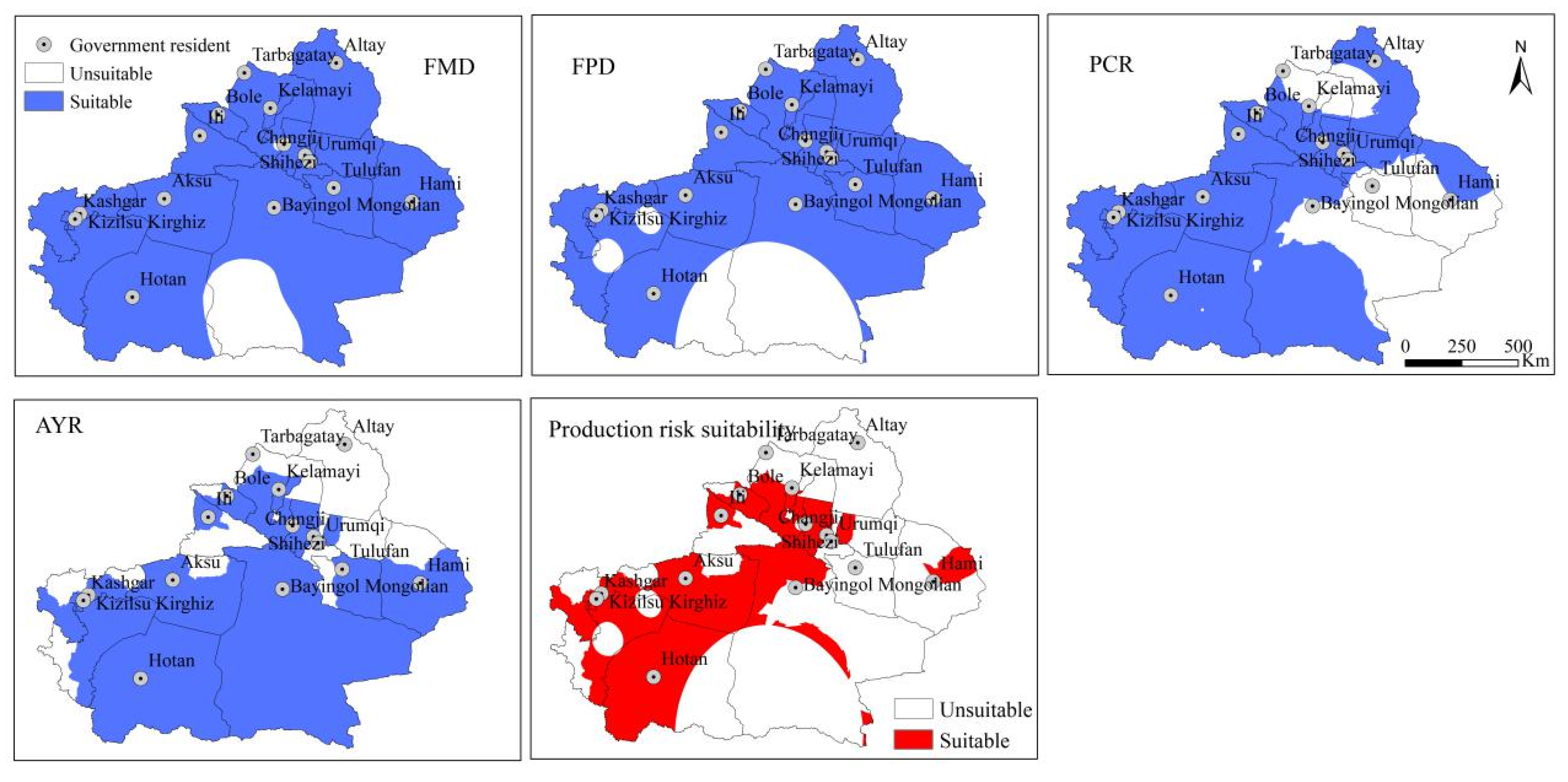
2.2.3. Production Risk
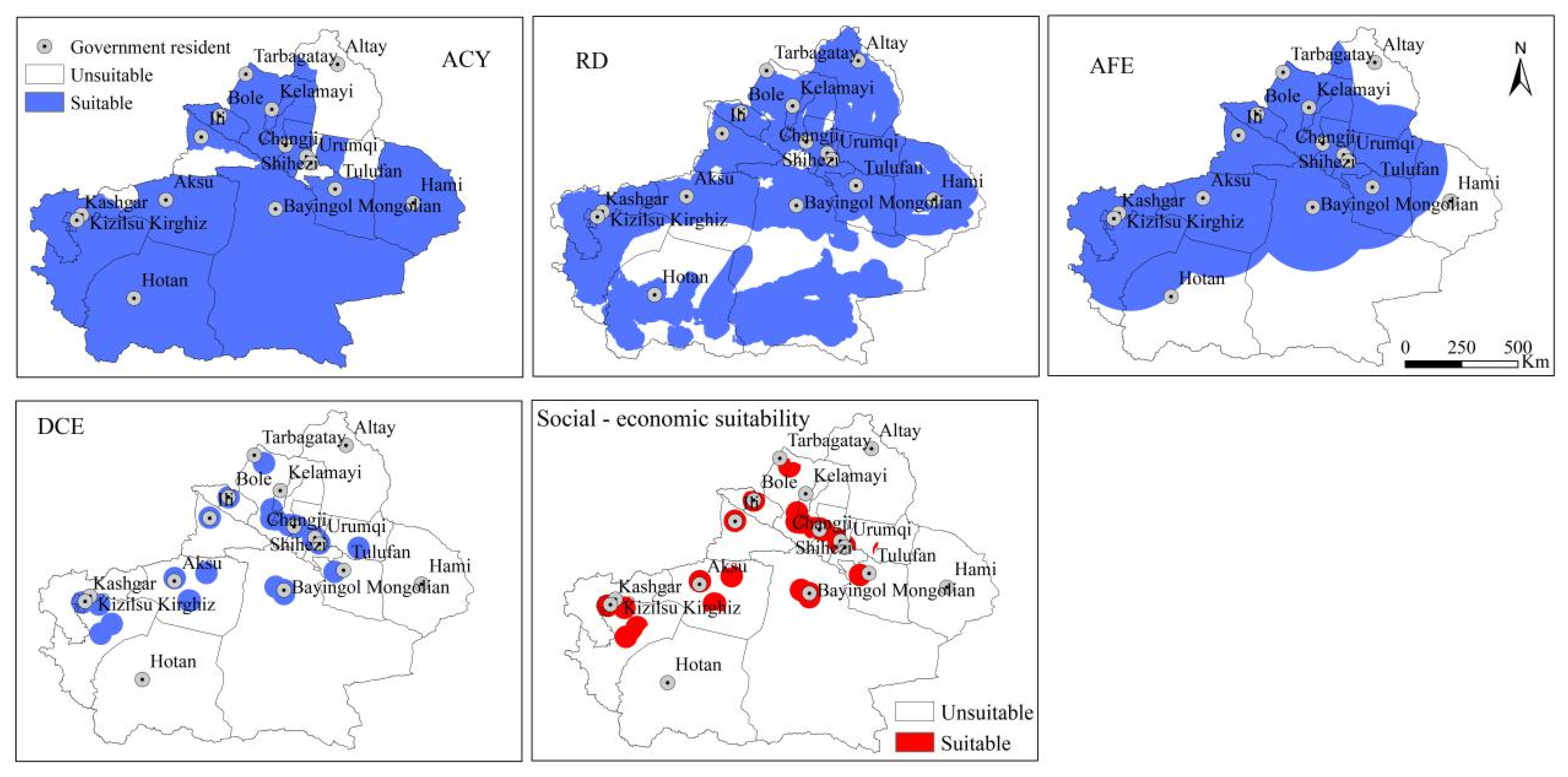
2.2.4. Socioeconomic Data
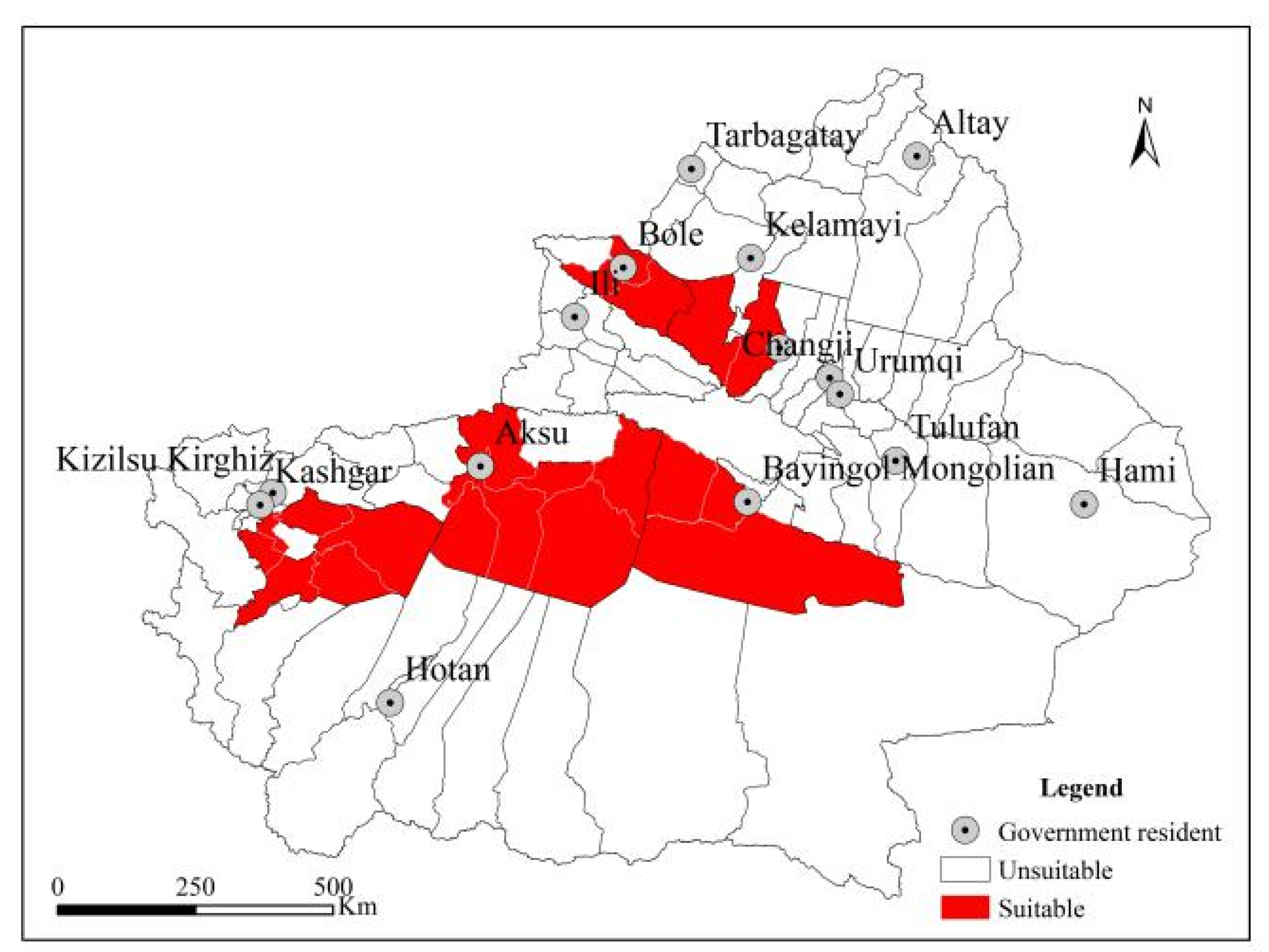
2.2.5. Production History

| Indicators | EMC | EMMC | LSC | Data | Time | |
|---|---|---|---|---|---|---|
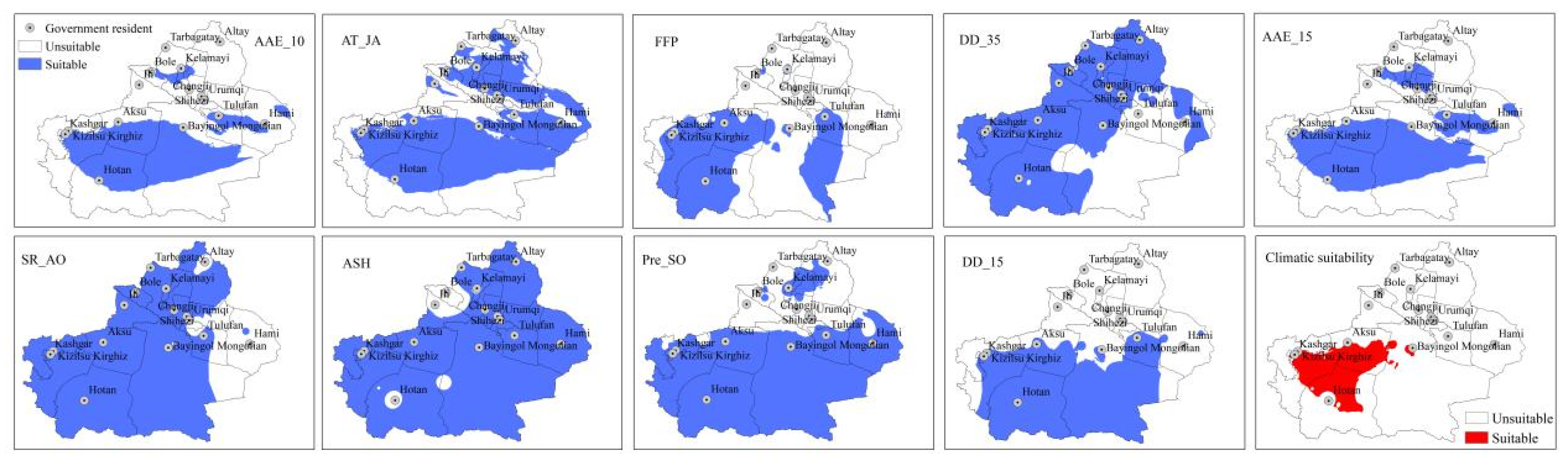
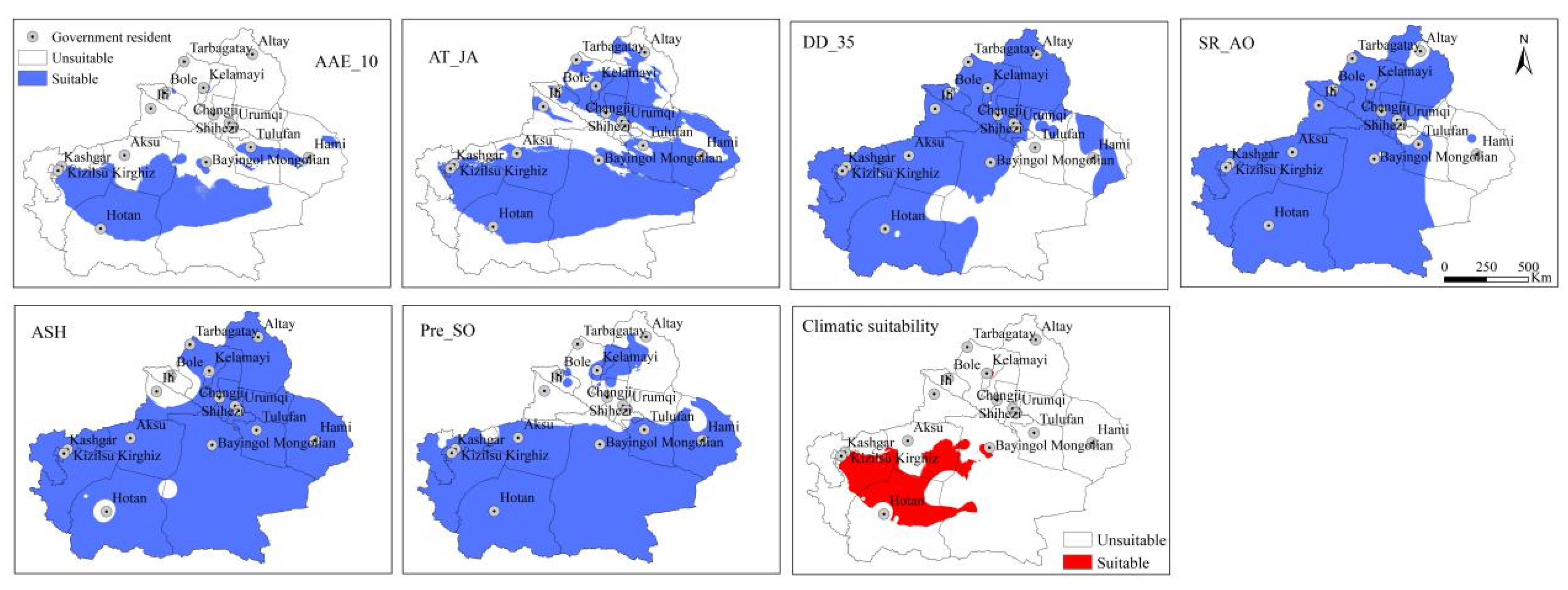
| Meteorological data | AAE_10 (°C) [28] | >3500 | >3800 | >4000 | Average daily temperature 1 | 1980–2018 |
| AAE_15 (°C) [36] | -- | >3000 | -- | |||
| AT_JA (°C) [28] | 20–30 | 20–30 | 20–30 | |||
| DD_15 (day) [28] | -- | >155 | -- | |||
| FFP (day) [28] | >170 | >180 | -- | Daily minimum temperature 1 | ||
| DD_35 (day) | ≤10 | ≤10 | ≤10 | Daily maximum temperature 1 | ||
| SR_AO [28] | 60–70% | 60–70% | 60–70% | Sunshine hours 1 | ||
| ASH (hours) [28,36] | ≥2700 | ≥2700 | ≥2700 | |||
| Pre_SO (mm) | <27.47 | <27.47 | <27.47 | Precipitation 1 | ||
| Soil and water | Slope | <5 | <5 | <5 | Slope 2 | -- |
| ST | sandy loam | sandy loam | sandy loam | CS_WSD 3 | -- | |
| SD (cm) [29] | >30 | >30 | >30 | |||
| S_PH | 6.5–8 | 6.5–8 | 6.5–8 | |||
| DD | >0 | >0 | >0 | River 4 | -- | |
| TAW | >0 | >0 | >0 | RYM 5 | 2010–2016 | |
| Socioeconomic data | ACY | High | High | High | County-level cotton yield 6 | 2015–2017 |
| RD | High | High | High | Road 7 | -- | |
| DCE | High | High | High | DSE 8 | -- | |
| AFE | Easy | Easy | Easy | |||
| Production risk | FMD | Low | Low | Low | Meteorological disasters 9 | 2000–2011 |
| FPD | Low | Low | Low | Pest risk 9 | ||
| PCR | Small | Small | Small | Precipitation 9 | 1950–2018 | |
| AYR | Small | Small | Small | Cotton yield 10 | 1988–2017 | |
| Production history | SDB | YES | YES | YES | Seed production area 11 | -- |
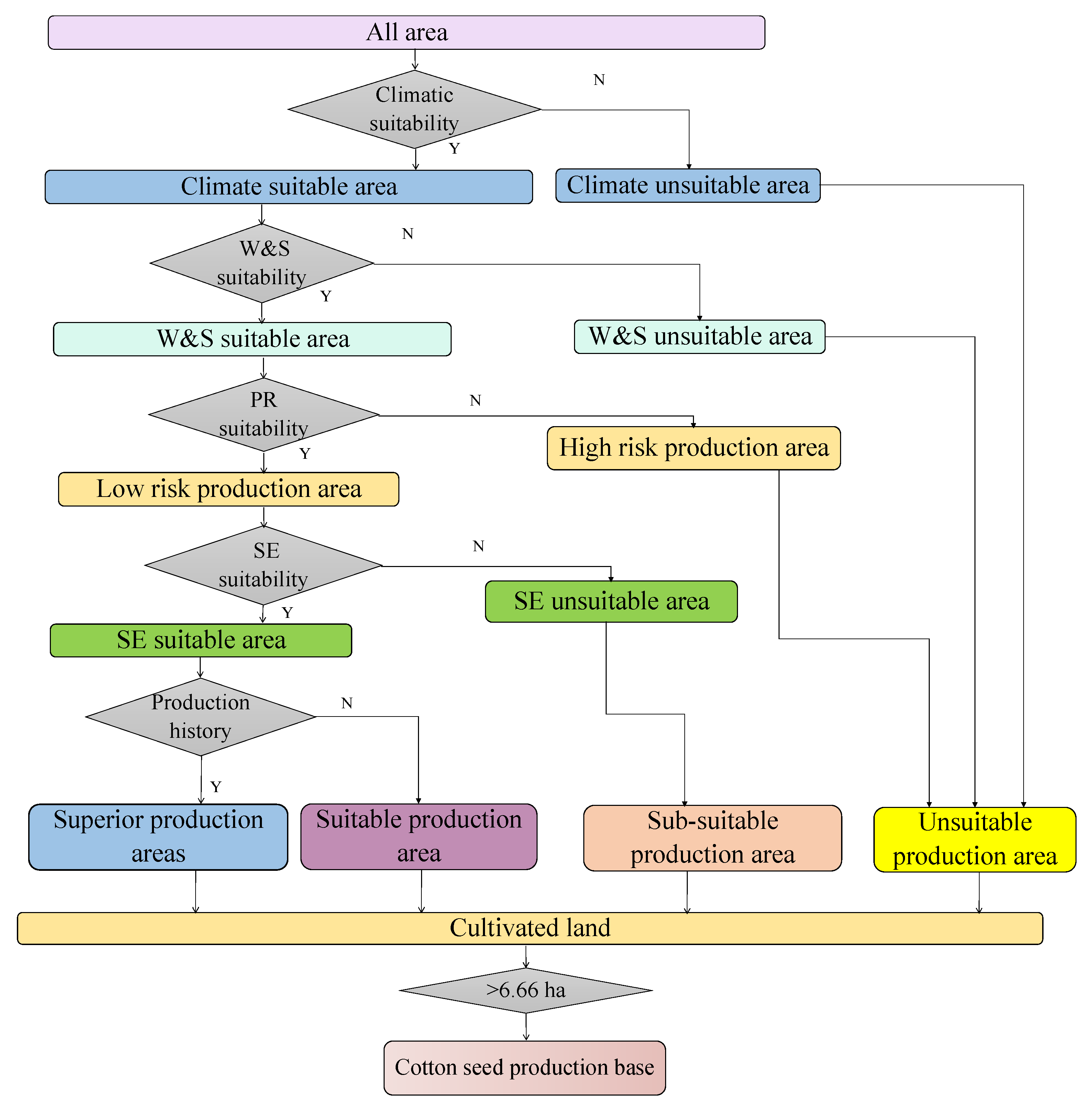
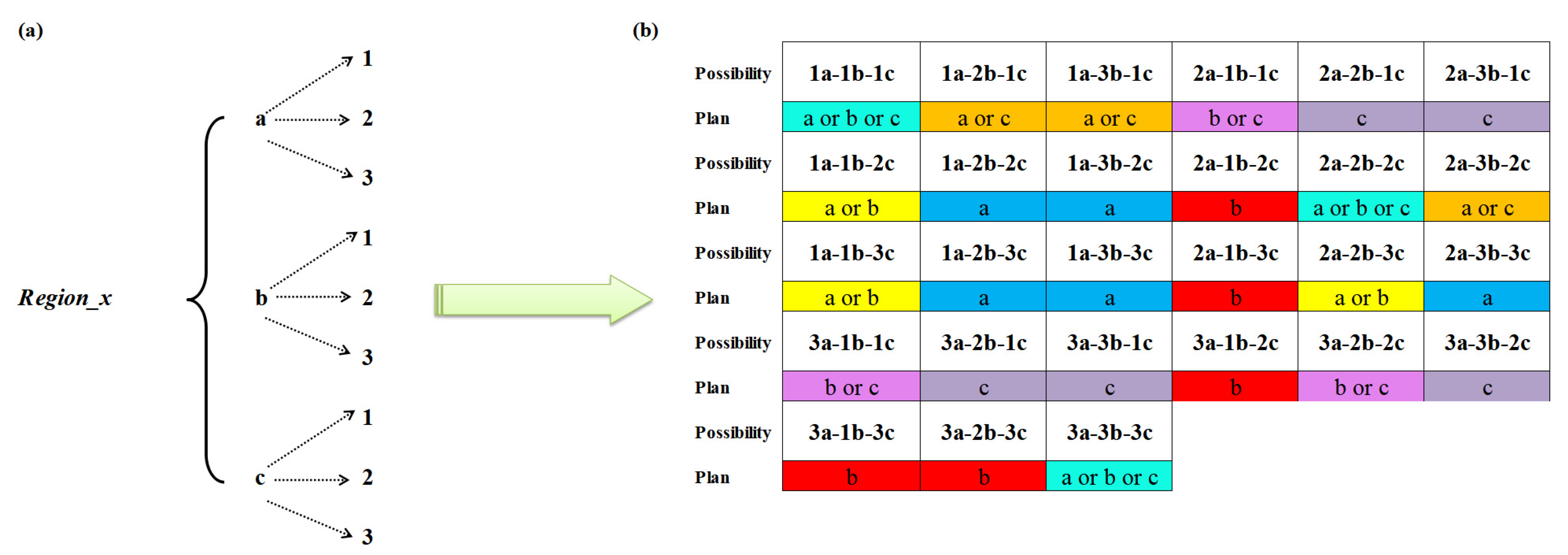
2.3. Methodology
3. Results
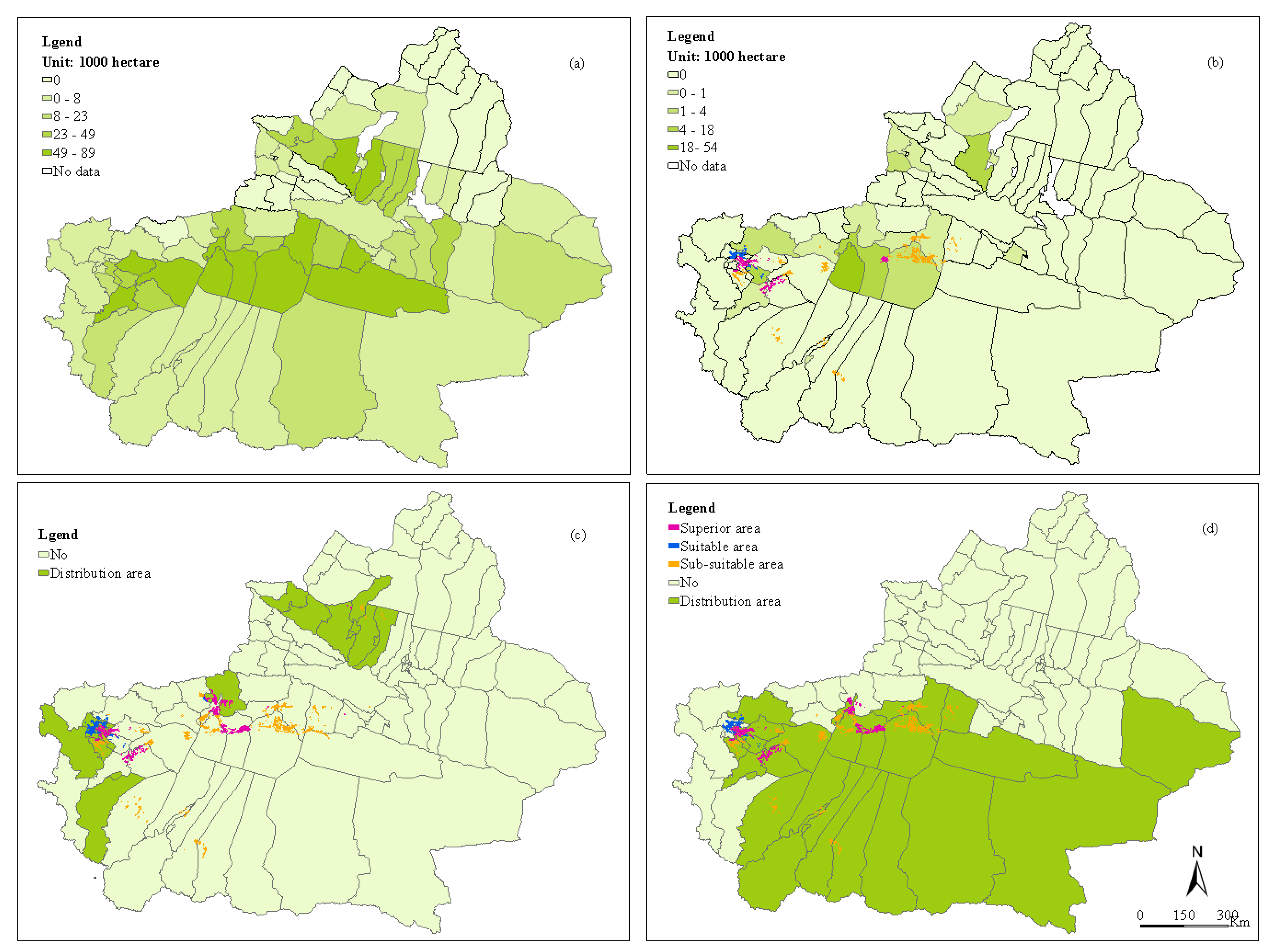
3.1. Suitable Climate Area for Cotton Seed Production
3.2. Suitable Soil and Water Area for Cotton Seed Production
3.3. Low-Risk Production Area for Cotton Seed Production
3.4. Suitable Social–Economic Area for Cotton Seed Production
3.5. Cotton Production History
3.6. Comprehensive Suitable Area for Cotton Seed Production
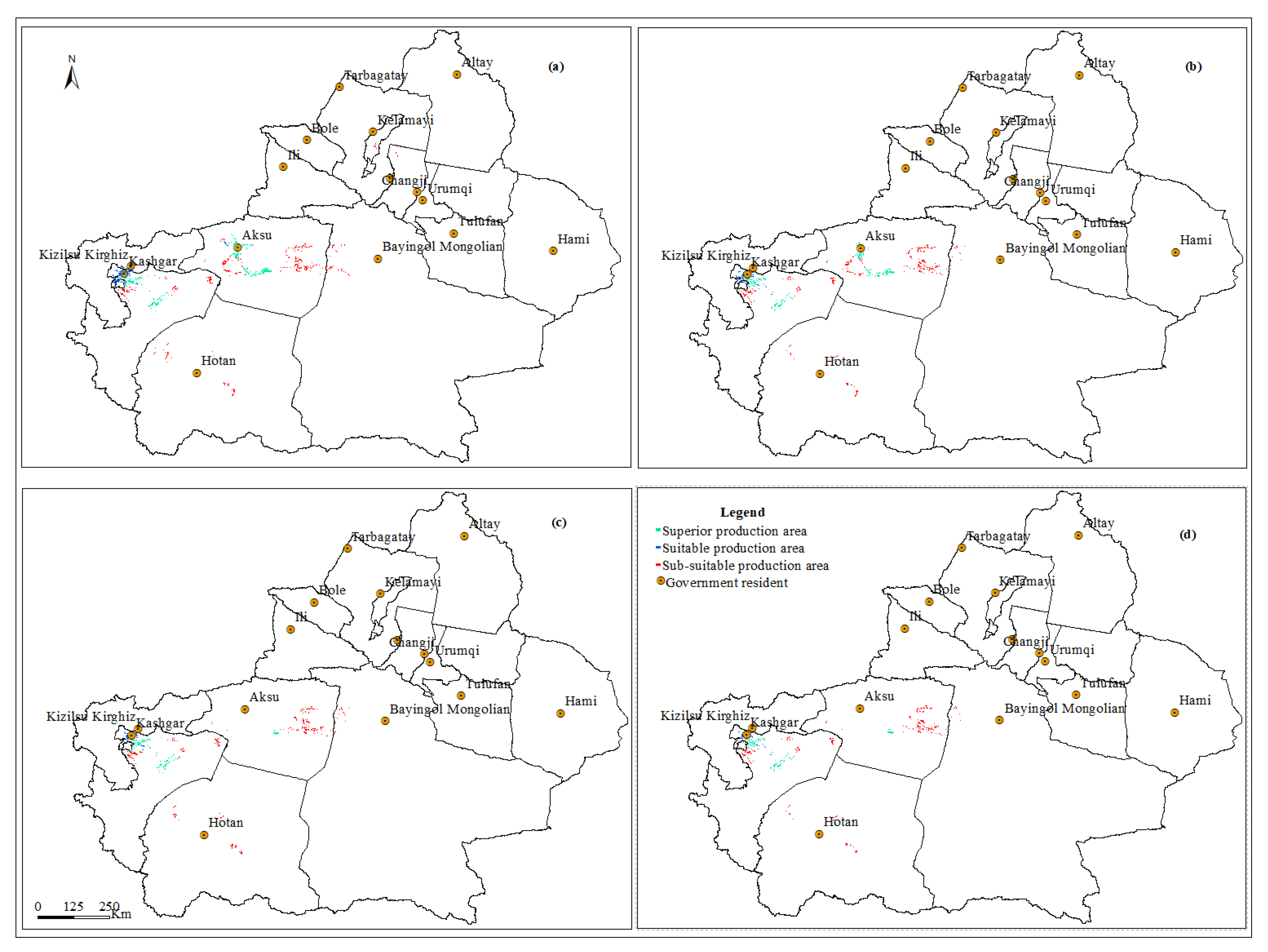
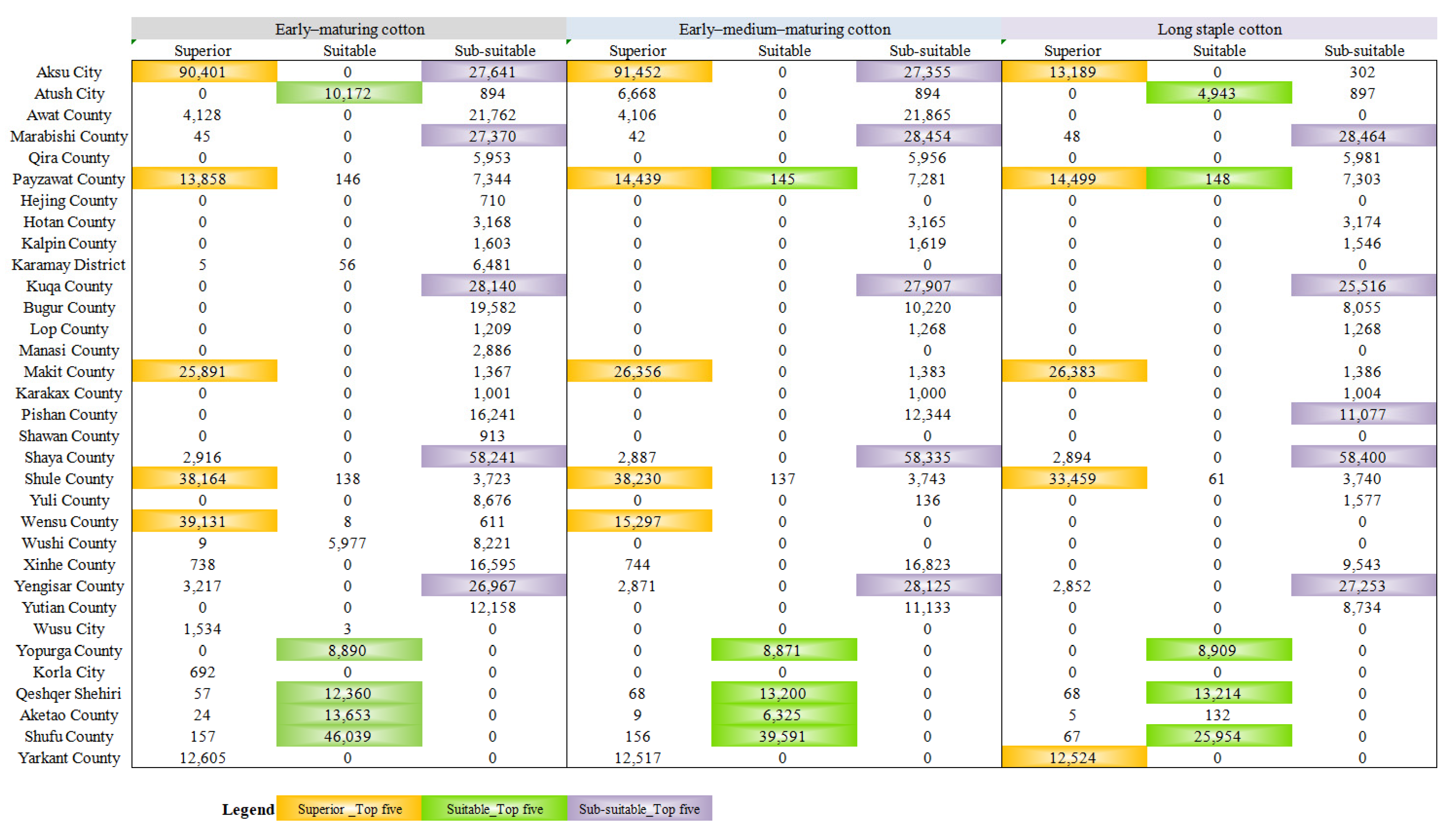
3.6.1. Early-Maturing Cotton (EMC) Seed Production Suitability
3.6.2. Early–Medium-Maturing Cotton (EMMC) Seed Production Suitability
3.6.3. Long Staple Cotton (LSC) Seed Production Suitability
3.7. Comprehensive Suitability for the Three Varieties of Cotton Seed Production Aeras
4. Discussion
4.1. Comparison of the Results
4.2. Sustainable Development of Cotton Seed Production in Xinjiang
4.2.1. The Necessity of Scientific Layout of Cotton Seed Production
4.2.2. Rational Utilization of Agricultural Resources in Xinjiang
5. Conclusions
Author Contributions
Funding
Institutional Review Board Statement
Informed Consent Statement
Data Availability Statement
Acknowledgments
Conflicts of Interest
References
- Li, Y.; Gao, X.; Tenuta, M.; Gui, D.; Li, X.; Xue, W.; Zeng, F. Enhanced efficiency nitrogen fertilizers were not effective in reducing N2O emissions from a drip-irrigated cotton field in arid region of Northwestern China. Sci. Total Environ. 2020, 748, 141543. [Google Scholar] [CrossRef] [PubMed]
- Reddy, K.R.; Brand, D.; Wijewardana, C.; Gao, W. Temperature effects on cotton seedling emergence, growth, and development. Agron. J. 2017, 109, 1379–1387. [Google Scholar] [CrossRef]
- Ma, C.; Mamat, S.; Yao, J.; Isak, G. Spatio-temporal changes of cotton production in China from 1950 to 2015. Acta Geogr. Sin. 2020, 75, 1699–1710. [Google Scholar]
- National Bureau of Statistics of China. China Statistical Yearbook. 2019. Available online: http://www.stats.gov.cn/tjsj/ndsj/ (accessed on 9 April 2021).
- Zhu, Q. Spatial Distribution Transferring of China’s Main Cotton Production Areas from 1980 to 2002. Ph.D. Thesis, China Agricultural University, Beijing, China, 2005. [Google Scholar]
- Wang, J.; Zhao, S.; Tan, X.; Liang, Y.; Gong, Z.; Ai, X.; Guo, J.; Maimaiti, M.; Li, X.; Zheng, J. Production situation and cotton seed industry development report in Xinjiang cotton planting region in 2018. Cotton Sci. 2019, 41, 9–14. [Google Scholar]
- Zheng, J.; Wang, J.; Liang, Y.; Gong, Z.; Ai, X.; Guo, J.; Mo, M.; Li, X. The present status and prospect of cotton seed industry in Xinjiang. China Cotton 2020, 47, 1–8. [Google Scholar]
- Schlenker, W.; Roberts, M.J. Nonlinear temperature effects indicate severe damages to US crop yields under climate change. Proc. Natl. Acad. Sci. USA 2009, 106, 15594–15598. [Google Scholar] [CrossRef] [Green Version]
- Raja Reddy, K.; Hodges, H.F.; Mckinion, J.M. Crop modeling and applications: A cotton example. Adv. Agron. 1997, 59, 225–290. [Google Scholar] [CrossRef]
- Chen, C.; Pang, Y.; Pan, X.; Zhang, L. Impacts of climate change on cotton yield in China from 1961 to 2010 based on provincial data. J. Meteorol. Res. 2015, 29, 515–524. [Google Scholar] [CrossRef]
- Hodges, H.F.; Reddy, K.R.; Mckinion, J.M.; Reddy, V.R. Temperature effects on cotton. Bull. Miss. Agric. For. Exp. Stn. 1993. [Google Scholar] [CrossRef]
- Snider, J.L.; Oosterhuis, D.M.; Skulman, B.W.; Kawakami, E.M. Heat stress-induced limitations to reproductive success in Gossypium hirsutum. Physiol. Plant. 2009, 137, 125–138. [Google Scholar] [CrossRef] [PubMed]
- Xu, B.; Chen, Y.; Wang, H.; Zhao, W.; Zhou, Z. Elevated temperature and waterlogging decrease cottonseed quality by altering the accumulation and distribution of carbohydrates, oil and protein. Physiol. Plantarum 2020, 171, 108–124. [Google Scholar] [CrossRef] [PubMed]
- Bange, M.; Constable, G.; Johnston, D.; Kelly, D. A method to estimate the effects of temperature on cotton micronaire. J. Cotton Sci. 2010, 14, 164–172. [Google Scholar]
- Reddy, K.R.; Davidonis, G.H.; Johnson, A.S.; Vinyard, B.T. Temperature regime and carbon dioxide enrichment alter cotton roll development and fiber properties. Agron. J. 1999, 91, 851–858. [Google Scholar] [CrossRef]
- LIAKATAS, A.; ROUSSOPOULOS, D.; WHITTINGTON, W.J. Controlled-temperature effects on cotton yield and fibre properties. J. Agric. Sci. 1998, 130, 463–471. [Google Scholar] [CrossRef] [Green Version]
- Wanjura, D.F.; Barker, G.L. Cotton lint yield accumulation rate and quality development. Field Crop. Res. 1985, 10, 205–218. [Google Scholar] [CrossRef]
- Gipson, J.R.; Joham, H.E. Influence of night temperature on growth and development of cotton (Gossypium birsutum L.). II Fiber Properties1. Agron. J. 1968, 60, 296–298. [Google Scholar] [CrossRef]
- Luo, Q.; Bange, M.; Johnston, D. Environment and cotton fibre quality. Clim. Chang. 2016, 138, 207–221. [Google Scholar] [CrossRef]
- Zhang, S. Cotton planting zoning change in southern Xinjiang under the background of global warming. Chin. J. Agrometeorol. 2015, 36, 594–601. [Google Scholar]
- Li, N.; Lin, H.; Wang, T.; Li, Y.; Liu, Y.; Chen, X.; Hu, X. Impact of climate change on cotton growth and yields in Xinjiang, China. Field Crops Res. 2020, 247, 107590. [Google Scholar] [CrossRef]
- Doma, P.R. Simulating the impacts of climate change on cotton production in the Mississippi Delta. Clim. Res. 2002, 22, 271–281. [Google Scholar]
- Tang, X.; Lv, X. The Relationship between climate change and yield of cotton in Shihezi region. Hubei Agric. Sci 2011, 50, 1533–1536. [Google Scholar] [CrossRef]
- McMichael, B.L.; Hesketh, J.D. Field investigations of the response of cotton to water deficits. Field Crop. Res. 1982, 5, 319–333. [Google Scholar] [CrossRef]
- Zeng, S. Study on the Competence of China Seed Company; Chinese Acadedmy of Agricultural Sciences: Beijing, China, 2006. [Google Scholar]
- Zhao, D.; Oosterhuis, D.M. Cotton responses to shade at different growth stages: Growth, lint yield and fibre quality. Exp. Agric. 2000, 36, 27–39. [Google Scholar] [CrossRef]
- Fontes, M.P.F.; Fontes, R.M.O.; Patrício, A.S. Carneiro. Land suitability, water balance and agricultural technology as a geographic-technological index to support regional planning and economic studies. Land Use Policy 2009, 26, 589–598. [Google Scholar] [CrossRef]
- Xu, P.; Zhang, Y.; Wang, L. On the allocation of cotton production base in Xinjiang. Acta Geogr. Sin. 1990, 45, 31–40. [Google Scholar]
- Liu, K.; Li, C. The harm of disastrous weather to cotton and the disaster prevention and reduction measures. J. Agric. Catastrophol. 2020, 10, 73–74. [Google Scholar]
- Zhang, Z. The Research on the Development of Cotton Industry of Xinjiang; Xinjiang University: Urumqi, China, 2013. [Google Scholar]
- Cao, Y. Comparison of Climate Change and Adaptability of Cotton Production in Northern and Southern Tianshan Mountains. Master’s Thesis, Shaanxi Normal University, Xi’an, China, 2012. [Google Scholar]
- Yu, Y.; Yu, G.; Wei, J. Analysis of spatial distribution and influencing factors of cotton production layout in Xinjiang under the backdrop of supply side reform. J. Arid Land Resour. Environ. 2019, 33, 74–80. [Google Scholar]
- Zhang, Z.; Wang, X.; Wang, C.; Zuo, L.; Wen, Q. National land cover mapping by remote sensing under the control of interpreted data. J. Geo Inf. Sci. 2009, 11, 216–224. [Google Scholar] [CrossRef]
- Zhang, Y.; Wu, K.; Yu, J.; Xia, J. Characteristics of precipitation and air temperature variation during 1951–2009 in north China. J. Nat. Resour. 2011, 26, 1930–1941. [Google Scholar]
- Jiang, H.; Zhang, L.; Cao, S.; Guo, T.; Liao, J.; Zhang, L. Risk assessment of grain yield loss caused by meteorological disasters in Liaoning Province. Agric. Res. Arid Areas 2011, 29, 238–244. [Google Scholar]
- Yao, Y. A new theory on Cotton regionalization in Xinjiang. China Cotton 2001, 28, 2–5. [Google Scholar]
- Niu, X. Study on the Productivity and Its Potential Productivity of Cotton in Xinjiang; Xinjiang Agricultural University: Urumqi, China, 2003. [Google Scholar]
- Shang, Y.; Zhu, H. Study on sustainable development model of agriculture in desert oasis: A case study of 149 regiment of the eighth agricultural division of Xinjiang production and construction corps. Xinjiang State Farms Econ. 2009, 3, 11–14. [Google Scholar]
- Wang, J.; Li, X.; Liang, Y.; Gong, Z. Cotton seed industry report of Xinjiang cotton planting area in 2017. Cotton Sci. 2018, 48, 5–11. [Google Scholar]
- Ali, M.; Ali, A.; Ashfaq, M.; Hassan, S.; Culas, R. Land use policy impact of climate smart agriculture (CSA) through sustainable irrigation management on resource use efficiency: A sustainable production alternative for cotton. Land Use Policy 2019, 88, 104113. [Google Scholar] [CrossRef]


| 1a1b1c | 2a2b2c | 3a3b3c | 1a1b1c | 2a2b2c | 3a3b3c | ||
|---|---|---|---|---|---|---|---|
| Aksu City | 13,120.09 | -- | 297.35 | Makit County | 25,019.14 | -- | 1334.95 |
| Aketao County | 4.27 | 128.89 | -- | Karakax County | -- | -- | 992.68 |
| Atush City | -- | 4883.96 | 874.41 | Pishan County | -- | -- | 10,441.60 |
| Marabishi County | 38.83 | -- | 26,639.46 | Shaya County | 2875.25 | -- | 57,310.81 |
| Qira County | -- | -- | 5838.12 | Yarkant County | 12,177.45 | -- | -- |
| Payzawat County | 13,474.88 | 141.73 | 7172.27 | Shufu County | 64.58 | 25,571.23 | -- |
| Hotan County | -- | -- | 3122.02 | Shule County | 32,576.64 | 59.99 | 3629.58 |
| Kalpin County | -- | -- | 1521.36 | Yuli County | -- | -- | 136.45 |
| Kuqa City | -- | -- | 25,008.14 | Xinhe County | -- | -- | 8990.72 |
| Bugur County | -- | -- | 7893.04 | Yengisar County | 2697.67 | -- | 24,448.64 |
| Lop County | -- | -- | 1198.96 | Yutian County | -- | -- | 8637.22 |
| Qeshqer Shehiri | 56.96 | 12,172.54 | -- | Yopurga County | -- | 8716.17 | -- |
Publisher’s Note: MDPI stays neutral with regard to jurisdictional claims in published maps and institutional affiliations. |
© 2021 by the authors. Licensee MDPI, Basel, Switzerland. This article is an open access article distributed under the terms and conditions of the Creative Commons Attribution (CC BY) license (https://creativecommons.org/licenses/by/4.0/).
Share and Cite
Niu, Y.; Xie, G.; Xiao, Y.; Qin, K.; Liu, J.; Wang, Y.; Gan, S.; Huang, M.; Liu, J.; Zhang, C.; et al. Spatial Layout of Cotton Seed Production Based on Hierarchical Classification: A Case Study in Xinjiang, China. Agriculture 2021, 11, 759. https://doi.org/10.3390/agriculture11080759
Niu Y, Xie G, Xiao Y, Qin K, Liu J, Wang Y, Gan S, Huang M, Liu J, Zhang C, et al. Spatial Layout of Cotton Seed Production Based on Hierarchical Classification: A Case Study in Xinjiang, China. Agriculture. 2021; 11(8):759. https://doi.org/10.3390/agriculture11080759
Chicago/Turabian StyleNiu, Yingnan, Gaodi Xie, Yu Xiao, Keyu Qin, Jingya Liu, Yangyang Wang, Shuang Gan, Mengdong Huang, Jia Liu, Caixia Zhang, and et al. 2021. "Spatial Layout of Cotton Seed Production Based on Hierarchical Classification: A Case Study in Xinjiang, China" Agriculture 11, no. 8: 759. https://doi.org/10.3390/agriculture11080759
APA StyleNiu, Y., Xie, G., Xiao, Y., Qin, K., Liu, J., Wang, Y., Gan, S., Huang, M., Liu, J., Zhang, C., & Zhang, C. (2021). Spatial Layout of Cotton Seed Production Based on Hierarchical Classification: A Case Study in Xinjiang, China. Agriculture, 11(8), 759. https://doi.org/10.3390/agriculture11080759