Article

Site-Specific Forage Management of Sericea Lespedeza: Geospatial Technology-Based Forage Quality and Yield Enhancement Model Development

1
Institute for Environmental Spatial Analysis, University of North Georgia, 3820 Mundy Mill Road, Oakwood, GA 30566, USA
2
Department of Agricultural Sciences, Fort Valley State University, 1005 State University Drive, Fort Valley, GA 31030, USA
3
Richland School District Two, 124 Risdon Way, Columbia, SC 29223, USA
4
Institute for Global Food Security, Queen’s University, University Road, Belfast BT7 1NN, UK
5
Department of Veterinary Tropical Diseases, Faculty of Veterinary Science, University of Pretoria, Private Bag x04, Onderstepoort 0110, South Africa
*
Author to whom correspondence should be addressed.
Agriculture 2020, 10(9), 419; https://doi.org/10.3390/agriculture10090419
Submission received: 27 January 2020 / Revised: 14 September 2020 / Accepted: 14 September 2020 / Published: 22 September 2020

Abstract

:
Site-specific forage management (SSFM), comprising growth observation, impact assessment, and timely strategic response to small variations in sericea lespedeza (SL; Lespedeza cuneata (Dum-Cours.) G. Don) production, has been envisioned as a life-changing approach for resource-poor (R-P) farmers in developing countries, assisting in the effective rearing of their small ruminants. The application of geospatial technologies, including geographic information systems (GIS), remote sensing, global navigation satellite system, and information technology, can support SSFM but has not been widely used for site-specific forage management. From our previous studies, it appears that the entire range of condensed tannins of lespedeza, namely extractable condensed tannin (ECT), fiber-bound condensed tannin (FBCT), and protein-bound condensed tannin (PBCT), as well as crude protein (CP), are excellent for promoting small ruminant digestion and overall health. The goal of this study was to develop an SSFM strategy for SL to enhance animal production in areas of drought-prone, low pH, marginally infertile soils. To achieve this goal, study objectives were to: (i) develop statistical and artificial neural networks-based (ANN) models to identify if a sound correlation exists among forage growth environmental features and SL-ECT content; (ii) determine suitability criteria, including climate, soil, and land use/land cover (LULC), for mass scale production of SL and collect supporting environmental geospatial data; and (iii) develop an automated geospatial model for SL growth suitability analysis in relation to optimal areas for its production in a case-study location. Telemetric data and individual climatologic parameters (including minimum, maximum, and average temperature, humidity, dewpoint, soil temperatures at three depths, soil moisture, evapotranspiration, total solar radiation, and precipitation) were found to correlate well (>75%) with the forage production parameters, including values of SL-ECT from the Fort Valley State University (FVSU) research station in Georgia in the southern United States. A backpropagation neural network (BPNN) model was developed using similar climatic input parameters, along with elevation (topography) and a normalized difference vegetation index (NDVI) to estimate the forage’s ECT with a testing root mean square error (RMSE) of 1.18%. With good correlation obtained between the climatic, soil, slope, and land cover input parameters, and SL-ECT as the output parameter, an SSFM model was developed with potential application to R-P farmers in areas suitable for SL establishment and growth. Eswatini (previously Swaziland), a landlocked country in southern Africa, in which numerous R-P small ruminant (sheep and goat) farmers reside, was used as the case study location to develop the SL production suitability model. Geospatial data were used for automated model development in an ArcGIS Pro ModelBuilder platform to provide information on where to grow SL efficiently to economically feed small ruminants. Land use/land cover, soil, topography, and climate based geospatial data of the region helped in the development of the automated SSFM geospatial model for spatial growth suitability location determination to assist farmers of Eswatini with their SL production decision making. This automated model can easily be replicated for farmers in other countries in Africa, as well as in other parts of the world having similar climatic conditions.

1. Introduction

Sericea lespedeza (SL; Lespedeza cuneata (Dum-Cours.) G. Don) is a drought-tolerant warm-season perennial forage legume well adapted to the southeastern United States [1], and the crop is also grown in arid or semi-arid locations of South Africa and other southern African countries [2,3]. As a forage crop, SL possesses numerous desirable qualities that enable it to be used for grazing, hay production, silage and conservation purposes [4]. It is a nutrient-rich forage and very suitable for livestock grazing by both small (sheep and goats) and large (cattle) ruminants, as it is non-bloating due to its high concentration of condensed tannins [1]. The advantages of cultivating this crop for livestock feed are: (1) it is resistant to diseases and is rarely attacked by insects; (2) mature plants can compete very well with grass; (3) it is a deep-rooted legume and hence can draw water from the subsoil even in conditions of drought, and fix atmospheric nitrogen; (4) even though it can grow on nutrient deficient soil, it grows very well also on loam and sandy loam soils; and (5) it can grow well under conditions of low pH and high drainage ability (high permeability), as in much of the southeastern United States [1] and in other areas around the world with similar growing conditions, such as in southern African countries [2,3]. After establishment, maintenance costs of SL are low compared to other forages. In a report from Alabama, SL was more economical in terms of total pasture costs/kg of gain of stocker steers than other forage crops adapted to the region [5].
In addition to its many agronomic advantages, such as that, as a low-input legume, it requires less fertilizer support than most crops in this category, recent work with SL has highlighted its health and environmental benefits, with excellent bioactivity reported against gastrointestinal nematode [6] and coccidial infections [7,8], rumen methane suppression [9], rumen protein bypass [10], and Musca domestica L. (common housefly) larval suppression in manure [11]. These bioactivity attributes of SL have been associated with the high concentration and unique structure of its condensed tannins, which are made up of nearly pure (up to 98%) prodelphinidin, a very reactive type of tannin [8,12]. As a low-input, soil-building nutraceutical forage that has both nutritional and health benefits as a natural dewormer, SL is particularly well-suited for use by limited-resource producers to improve sustainability of their livestock production systems [13].
Despite the potential of SL to improve the productivity and health of livestock for resource-poor (R-P) farmers in areas where it is well-adapted, such as in southern Africa [13,14], there are challenges to the successful establishment and management of this crop. Because of its very small seed size and relatively poor seedling vigor, SL does not compete well with other plants and should be planted as a monoculture [1]. In addition, achieving optimal nutritive value and stand viability of SL, whether grazed or harvested for hay, is based upon appropriate plant height both before and after (stubble height) plant removal [1]. Precision agriculture techniques may greatly assist in the profitable utilization of this forage by producers.
Any crop can grow with higher efficiency and better yield if it is grown on soil, elevation, land use, and climatic factors advantageous for its production. Many studies have established geographic information systems (GIS)-multi-criteria analysis (MCA) or spatial data integration to assess spatial crop suitability [15,16,17,18]. Such integrated GIS-MCA techniques have been considered within a large number of disciplines, including plant, animal, crop, and horticulture production optimization studies using suitable criteria [16,17]. Yalew et al. [19] developed a web-based GIS-MCA framework for agricultural land suitability assessment using remote sensing, GIS, and the Google Earth Engine. Reed and Panda [15] developed an automated geospatial model to map the entire state of Georgia in the United States, suggesting high, moderate, and low suitability spatial locations to grow blueberries in areas with low soil pH, <900 h of annual freezing, and generally on cleared land, adjacent to forest land cover. Panda and Bowman [16] determined spatial suitability for growing several cash crops in South Georgia to provide higher yield and more profit. This approach could be extended to suitability for forage production.
Site-specific crop management (SSCM), a tool of precision agriculture, involves spatial referencing, crop and climate monitoring, attribute mapping, decision support systems, and differential management actions [20,21,22]. It can result in increased production through more efficient use of inputs [23], thus improving the cost-benefit of crop production. A greater degree of precision is achieved through the use of geospatial technologies, including a combination of the four essential tools: remote sensing (RS), geographic information systems (GIS), global navigation satellite systems (GNSS), and information technology (IT), and then management of the resultant data [20,21,24,25].
While SSCM has commonly been applied in field and row crop management, its use for non-traditional horticultural crops or pasture is still uncommon, despite the fact that high nutrient pastures may benefit from following the components of SSCM, potentially to increase net returns and optimize resource use [26,27,28]. The delineation of pasture lands and geospatial technology-based spatial analysis can provide additional information for pasture management decision support, including biomass yield determination, fertilizer application scheduling, need-based irrigation scheduling, and pesticide application for pest and plant disease management. Remote sensing technology, supported by weather, soil, and water data analyses and their correlation with forage yield and quality analyses has the potential to improve profits for pasture owners by increasing animal production and enhancing animal sale value, as well as enhancing ecosystem (fauna) biodiversity [29,30,31,32].
Schellberg et al. [29] concluded that advances in agricultural research, using precision agriculture and an SSCM approach on grasslands, could provide major economic and environmental benefits. They suggested that most of the available technology is currently being applied on arable land, i.e., row crop agriculture, but not on grassland, although the latter contributes substantially to agricultural land use, as well as to capital and income. In their review, the authors discussed a range of current developments and future prospects for utilization, including digital image processing, remote sensing, yield measurement, and site-specific management on grasslands [29]. They suggested that grassland scientists or pasture/forage researchers can significantly contribute to the development of this field, using existing computer simulation models and developing newer models to contribute to successful precision agriculture on grassland. Schaller et al. [30] developed “Climate Smart Agriculture” (CSA) that addresses the challenges posed from climate change in agricultural production, especially forage management. The team used the model with help from United Nations Food and Agricultural Organization (UN-FAO) to create a pathway towards sustainable development and food security in arid and semiarid locations. Using an SSCM approach, the three primary objectives of CSA are increasing crop, livestock and fisheries productivity and income, enhancing resilience or adaptation of livelihoods and ecosystems in climate extremes, and reducing and removing greenhouse gas emissions from the atmosphere [30]. Other authors also strongly suggest interdisciplinary research for enhancing linkage of existing knowledge on precision agriculture technology with grassland science and animal science [29]. The current investigation is a step towards a goal of site-specific forage management (SSFM) development for increased high quality forage production and increased animal production under arid or semi-arid climatic conditions.
Our research goal was achieved through the following objectives:
(1)
Develop statistical and artificial neural networks-based (ANN) models to identify correlation among crop growth environmental features and sericea lespedeza extractable condensed tannin (SL-ECT) content to confirm SSFM production suitability for this forage;
(2)
Determine suitability criteria, including climate, soil, and land use/land cover (LULC), for mass scale production of SL, and collect supporting environmental geospatial data;
(3)
Develop an automated geospatial model for SL growth suitability analysis in relation to the optimal areas for its production in a case-study location.

2. Materials and Methods
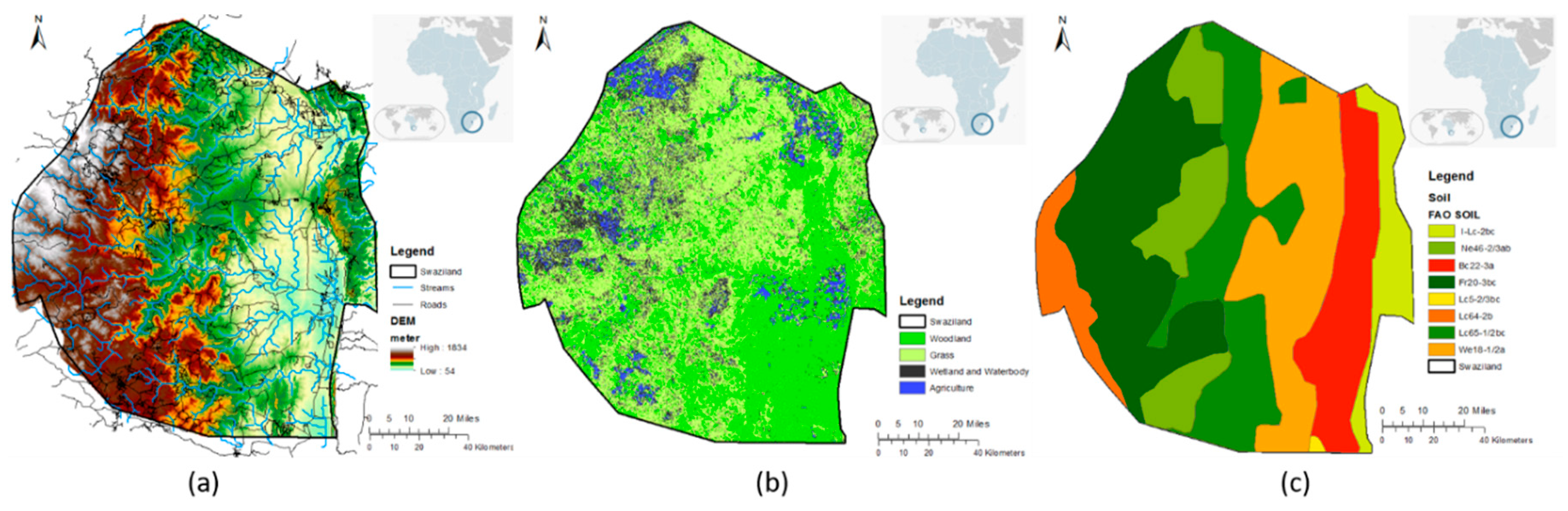
2.1. Study Area

Sericea lespedeza yield and forage quality research has been carried out since 2010 at Fort Valley State University (FVSU) in Georgia in the southern United States [7]. The FVSU site (32°32′27.834″ N; −83°53′45.884″ W) is in a semi-arid region, has a flat topography, is 322 km from the coast, and has silty loam soil (loamic/Areninovic). The forage was grown to determine how well SL physical parameters, including ECT content, protein and tannin content, yield, etc., are correlated with climatic, LULC, soil, and topography factors.
Once the correlations were confirmed for the FVSU site data, we used a case study site to test and develop our automated SL production suitability geospatial model as part of our SSFM development, with a long-term goal of enhancing quality of life for R-P farmers who rear small ruminants for a living in southern Africa and elsewhere in the world. The case study was conducted for the entire country of Eswatini (previously Swaziland), a landlocked country in South Africa (Figure 1—inset in the top-right of the map), in which numerous R-P small ruminant (sheep and goat) and cattle farmers reside. It has a land area of 17,364 km2 and is centered at approximately 26°30′ S longitude and 31°30′ E latitude, with a wide variety of landscapes, from mountains along the Mozambican border, to savannas in the east and rain forest in the northwest. The topography of the country ranges from 50 to 1800 m altitude (Figure 1a). The country’s land cover represents typical African bush, consisting of thorn trees and grasslands, (Figure 1b), with a huge potential for increased SL production [2]. Eswatini has similar climatic conditions to the southern United States, including FVSU. The country is divided into four climatic regions: the Highveld, Middleveld, Lowveld and Lubombo plateau, with predominantly summer rainfall, often in the form of thunderstorms, and dry winters. Annual rainfall ranges from 1000 and 2000 mm, decreasing eastwards, to a total of 500 to 900 mm per annum in the Lowveld. Temperature variations are related to the altitude of the different regions, with record temperatures of around 40 °C in summer in the Lowveld region. The soils of Eswatini mainly consist of sandy rocks and some loam (Lithosolic), along with brown to black loams or red clays (Vertisolic), and deep red, yellow and orange loams (Figure 1c). It is to be noted that climatic factors in Eswatini (Southern Africa) are very close to the climatic conditions of the southern United States (FVSU).

2.2. Field-Based Data Collection and Analysis

2.2.1. Environmental and Forage Nutrient Quality Data Collection and Processing

Statistical regression models were developed using environmental parameters as inputs versus forage nutrient quality data, such as SL leaf extractable condensed tannin (ECT), SL-ECT, as the output parameter. Artificial neural networks—backpropagation neural network (ANN-BPNN) models were developed using environmental parameters along with elevation and temporal normalized difference vegetation index (NDVI) of the site versus SL-ECT. A sensitivity analysis study was carried out to determine major contributing input parameters for SL-ECT yield estimation. The Georgia Automated Environmental Monitoring Network (http://www.georgiaweather.net/) weather station at the FVSU research station was used to generate environmental information for the study, with leaf, stem, and whole plant SL (forage) quality measurement being done weekly. Climatic data were downloaded and averaged for the entire period for which forage quality was estimated. The following weather-related data were obtained and analyzed for this SSFM models (statistical and ANN) development: maximum (max), minimum (min) and average (avg) 5 cm and 20 cm depth soil air temperature (°C), dewpoint (°C), relative humidity (%), and soil moisture, as well as evapotranspiration (mm), total solar radiation (MJ/m2) and total rainfall. As the forage quality component most directly related to SL bioactivity, SL-ECT was also used in yield estimation correlation models development.
As a case study, the Eswatini SSFM was developed using available and processed land cover, soil, and digital elevation models (DEM) and climatic data, including average annual temperature and precipitation. A detailed literature review was conducted to find suitable ranges of these parameters for efficient production of SL [4,15,16,17,18]. The land cover image was developed with a hybrid image segmentation approach using a combination of ISODATA unsupervised clustering and maximum likelihood supervised clustering algorithms in ArcGIS Pro (ESRI, Redlands, CA, USA) on Landsat 8 tiles of September 2017. The Landsat 8 images were downloaded from the USGS National Map (https://nationalmap.gov/) server and were mosaicked for land cover classification. The DEM was developed through the Shuttle RADAR Topographic Mission (https://www2.jpl.nasa.gov/srtm/) of the National Aeronautics and Space Administration (NASA), acquired from the National Map site, and a slope raster was created with the ArcGIS Pro SLOPE tool. The soil data were obtained from the UN-FAO world soil database (http://www.fao.org/soils-portal/soil-survey/soil-maps-and-databases/en/), and the attribute table was updated to obtain information for the SSFM decision support system (DSS) model development. Average precipitation and temperature rasters of the study area were acquired from the DIVA GIS (http://www.diva-gis.org/) geospatial data repository. These raster and vector data were processed in ArcGIS Pro software to bring them into a similar projection system and a common study area extent. Later, the soil vector data were converted to a raster file using the ‘Polygon to Raster’ tool of ArcGIS Pro with the applied characteristics of the soil layer for the SSFM DSS model development. All the rasters used in the model development were brought to a common spatial resolution using the image fusion approach developed by Panda et al. [33].

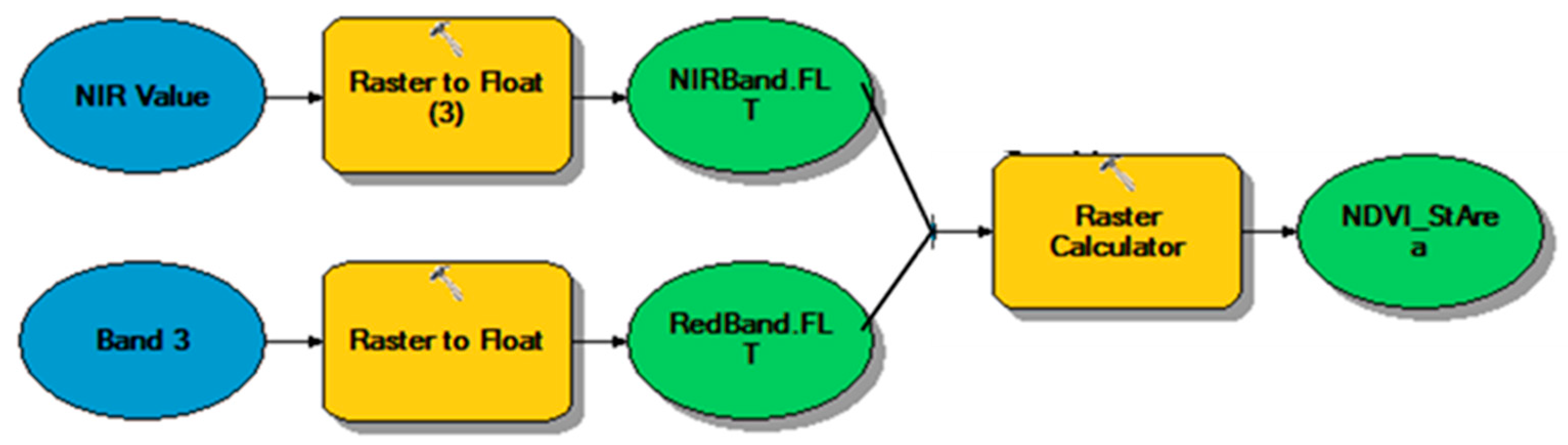
2.2.2. Remote Sensing Data Collection and Processing

High resolution (1 m) National Agricultural Imagery Program (NAIP), 4 band imagery of Year 2010 were obtained from the USDA NRCS Geospatial Data Gateway site (https://gdg.sc.egov.usda.gov/), corresponding with the FVSU research station where the SL was being grown and the forage quality was evaluated. The image acquisition dates were ascertained from the USDA Farm Service Agency shape file. Thus, the digital information obtained from the images were correlated with the dates closest to those on which the forage leaf, stem, and whole plant quality measurements were taken. Images were geometrically corrected with ArcGIS Pro software with NAD83 UTM Zone 17N projection system provision. Individual bands (R, G, B and IR) were separated/extracted from the Multispectral Scanner Sensor (MSS) image in ArcCatalog (ESRI, Redlands, CA, USA). As band combinations based on band ratios are mostly preferred by researchers for crop vigor or vegetation health analysis, NDVI was developed for the present study, based on the “Raster Calculator” tool of ArcGIS Pro and using Equation (1):
NDVI   =   ρ ir     ρ r ρ ir   +   ρ r
where, ρr and ρir are spectral reflectance from the R- and NIR-band images, respectively [34,35]. These NDVI data were used in the BPNN model development along with other environmental inputs used in statistical models development.
The images were downloaded on a county basis from the gateway site, with four discernible bands. For the research plot site, GIS shape files were created using the research plot location coordinates. These shape files were used in the “Extract by Mask” tool to crop the larger GeoTIFF image for analysis. In ArcCatalog, the model study area 4-band imagery was separated into individual bands (R, G, B and NIR). Of these, individual R- and NIR- band images were used in developing the NDVI raster ArcGIS Pro software ModelBuilder platform. Figure 2 shows the automated geospatial model developed for obtaining the NDVI rasters used in environmental parameters vs. forage quality correlation model development. The FVSU research site DEM raster was obtained from Geospatial Data Gateway (https://datagateway.nrcs.usda.gov/) to obtain the topographic information of the research sites. The elevation mean, min, and max values were obtained for the site, using the descriptive statistics tools of ArcGIS Pro.

2.2.3. Statistical Model Development

The environmental parameters (provided in Section 2.2.1), along with the elevation and NDVI digital values, were used as input parameters of the model, and the forage nutrient data were used as the output parameters. Statistical models were developed to obtain the input–output correlation between individual environmental parameters and the LS-ECT. This will allow information to be provided to farmers as to which environmental parameters need to be monitored to predict growth and nutrient quality content of SL as needed.

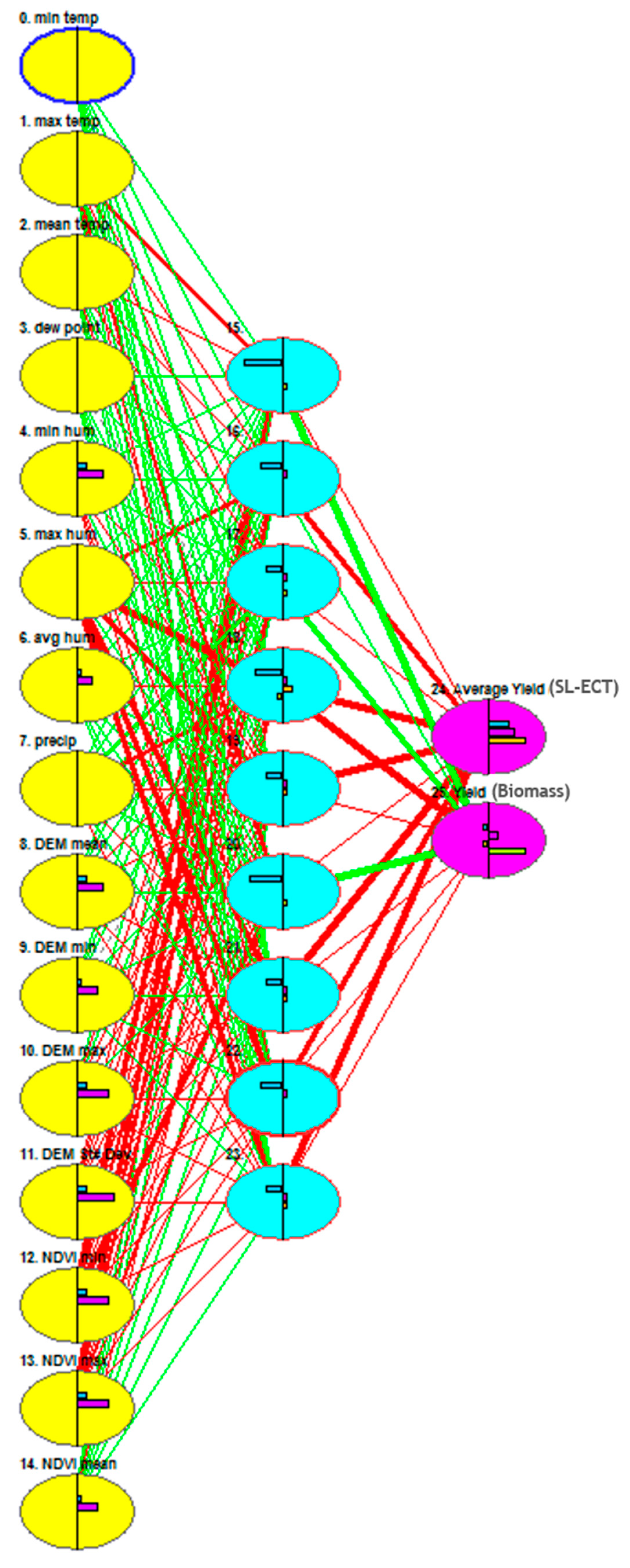
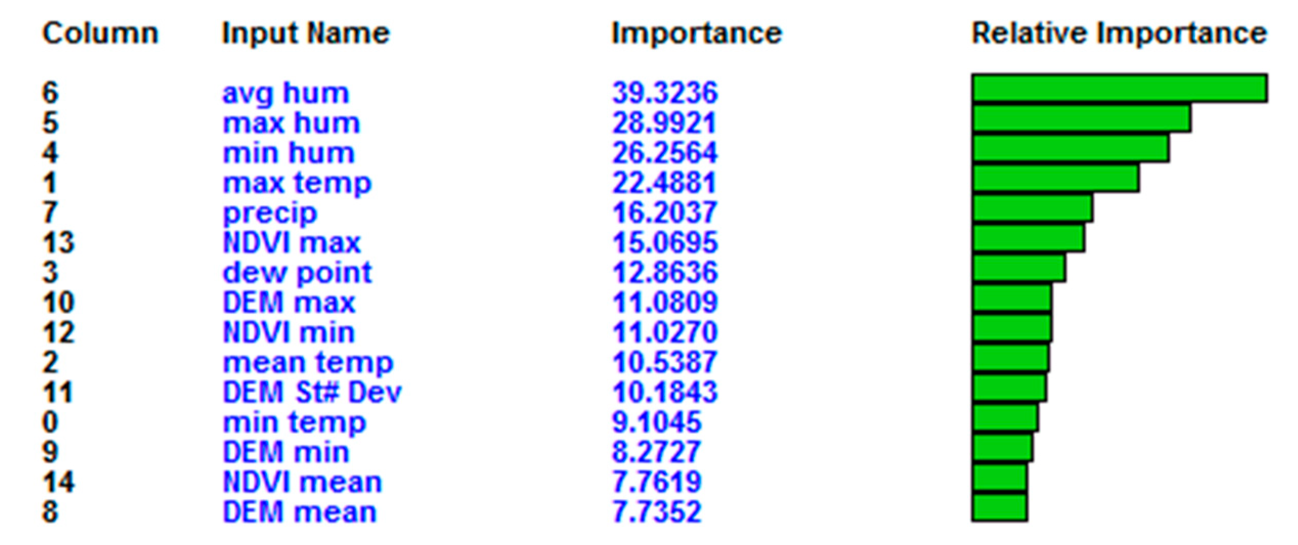
2.2.4. Artificial Neural Network (ANN) Model Development

To confirm the input environmental parameters correlation with forage quality (SL-ECT) data, a backpropagation neural network (BPNN) architecture in JustNN (http://www.justnn.com) neural network software was developed to predict the whole SL plant average ECT yield values using the environmental and remote sensing image parameters described previously, such as avg, max and min humidity, avg max and min temperature, precipitation, dew point min, max and mean, NDVI max, NDVI min, NDVI mean, max, min, and DEM mean and standard deviation. Figure 3 is an example of the BPNN model architecture (as of JustNN software) developed for the forage ECT prediction. Table 1 shows an example of the data used in the BPNN modeling. A neural network-based sensitivity analysis was also conducted, showing the levels of parameter correlation (importance) with the forage whole plant nutrient quality values. Another output parameter used in this BPNN model was biomass yield of the forage, but is not relevant for discussion in this study. Hidden layer weights were randomly assigned in each iteration based on the error back propagation analysis in this BPNN model, and the best-fit model used the optimum weight combination [36].

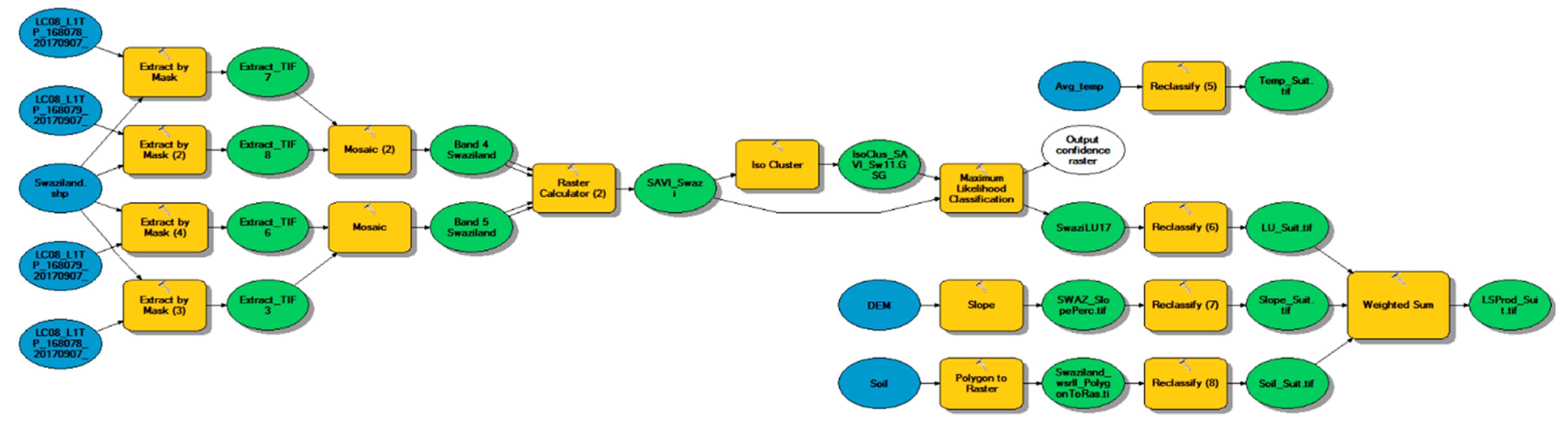
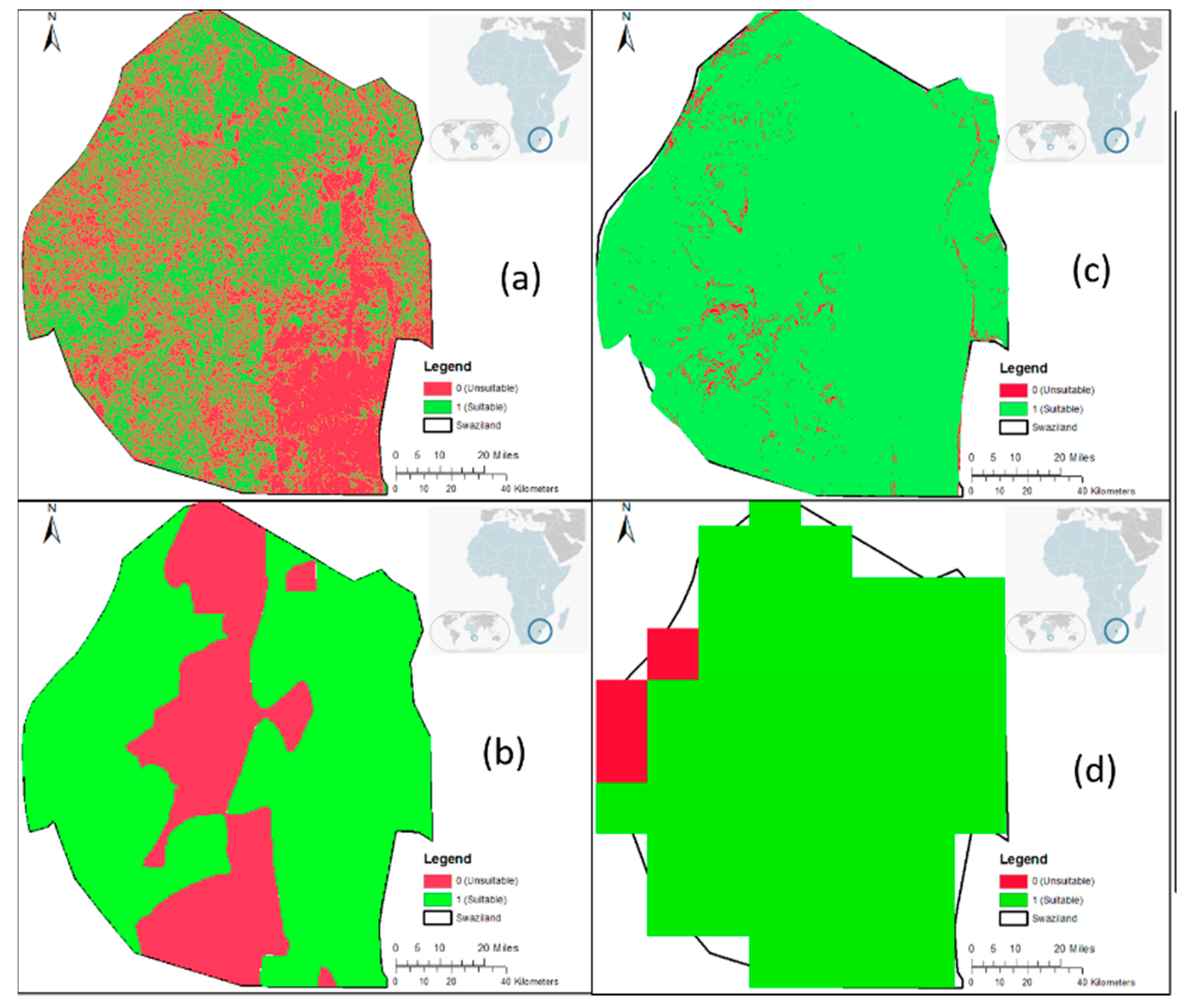
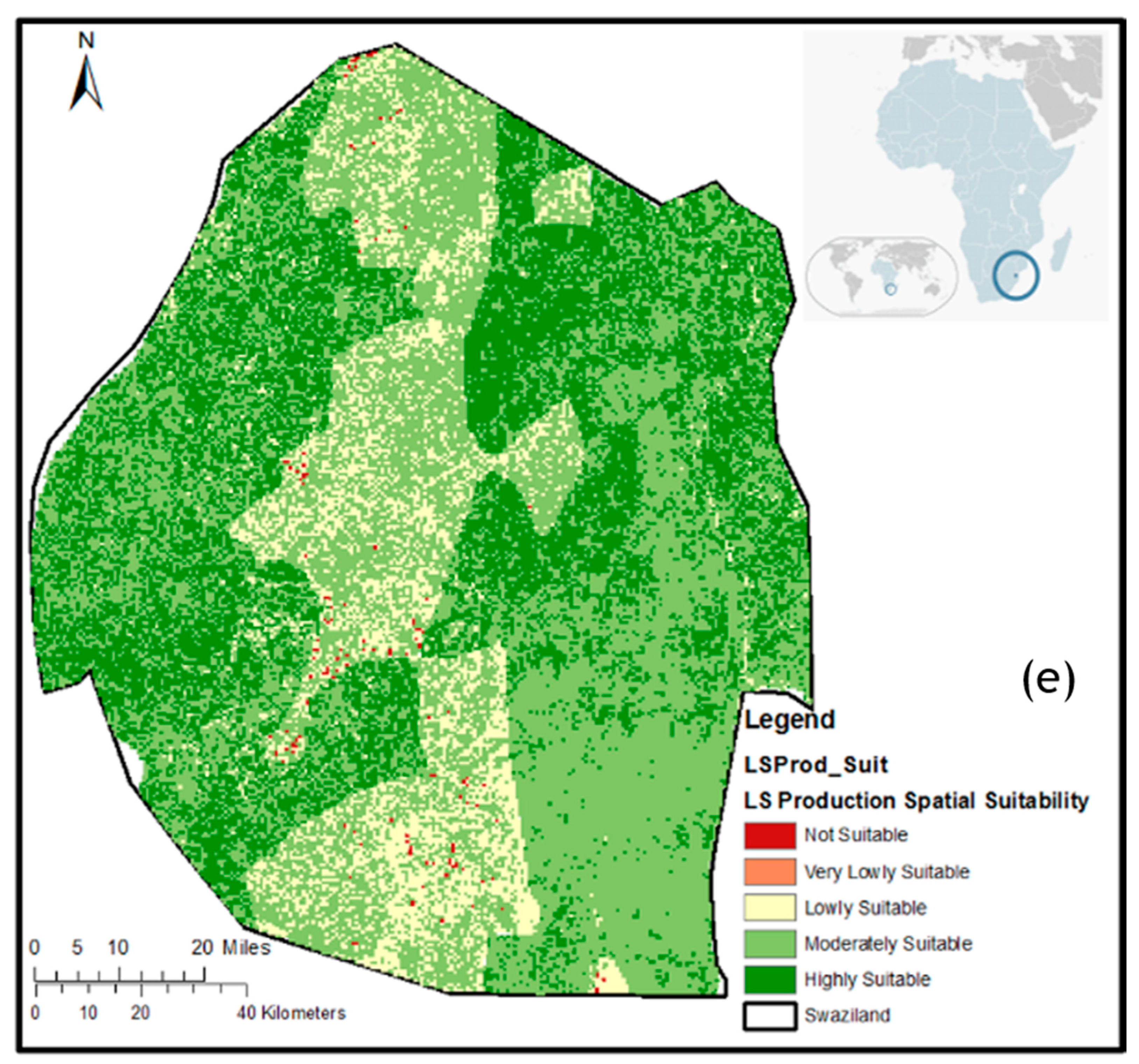
2.2.5. SSFM DSS Automated Geospatial Model Developed for Eswatini

As illustrated through the statistical and ANN “environmental factors vs. forage quality” correlation models, SL appears to be versatile as regards to localities, globally, where it should be able to grow effectively. However, testing premise would require conducting the SSFM DSS development of SL in such an area globally wherever the specific suitable production conditions exist. The SSFM DSS automated model was developed for Eswatini, where SL has been reported to grow well [2]. Our long-term goal is to eventually expand this SSFM model development process to the whole of southern Africa. In the current investigation, all the processed rasters were analyzed for their spatial suitability in the study area (Eswatini) for optimal production of SL using the properties described in Table 2. It was observed that both temperature and precipitation range suitability criteria were consistent for the entire country and hence were not used in the comprehensive SSFM DSS model development, but only soil, LULC, and slope rasters. All three rasters were reclassified to SL production suitability rasters individually using the ranges provided in Table 2. While developing the rasters, a value of 1 was provided for suitable soil spatial locations (pixels) and a value of 0 was provided for unsuitable spatial locations. Once all three (soil, LULC, and slope) suitability rasters were created, they were integrated (overlayed) together using the “Weighted Sum” tool of ArcGIS Pro. Table 2 shows the weights provided for each raster in the development of the final SL production spatial suitability raster, since a Delphi modeling approach suggested that each production parameter does not equally contribute to SL production. An automated geospatial model (Figure 4) was developed in ArcGIS ModelBuilder to complete the entire spatial modeling work process.

3. Results and Discussion

Statistical analyses of environmental parameters with the whole plant SL-ECT were carried out for five Julian days (118, 148, 178, 208, 245) of the year 2010 for the FVSU study site. Statistically significant correlations were obtained for each of the environmental factors with respect to the SL whole plant ECT prediction, with the coefficient of determination (R2) ranging from 0.54 to 0.96. Only the maximum relative humidity did not have a significant correlation (R2 = 0.0095) with whole forage ECT. Almost all models (>80%) provided more than 75% R2 values, thus suggesting that none of the environmental (climatic) production suitability criteria developed in this study for SL production would diminish the forage quality. Table 3 lists the correlational equations along with the corresponding R2 and standard error of prediction (SEP) values.
The neural network sensitivity analysis (Figure 5) of the input data indicated that the most important indicators of SL-ECT yield were as follows: humidity, temperature, and precipitation. The models (separate modeling application) indicate that substantial increases in precipitation would lead to only negligible increases in crop yield. Furthermore, the BPNN model used only selective climatic factors (out of 25 used in statistical model development) along with NDVI and elevation (slope), which were later to become part of our production suitability model development. In summary, all models indicate that SL tends to be drought resistant.
Our study, using ANN modeling, provided the following results: (1) higher minimum elevations produced negligibly lower ECT values for SL; (2) lower maximum elevations produced substantially lower SL-ECT values; (3) lower mean elevations produced lower SL-ECT values; (4) higher NDVI mean values corresponded to higher SL-ECT values and lower minimum NDVI values corresponded to lower SL-ECT values; and (5) higher NDVI max values corresponded to lower ECT values for SL. Even though this remains to be confirmed by further investigation, the results from the ANN model suggest that selective environmental parameters, topographic raster data, as well as remote sensing image-based data could be applicable for estimation of predicted biomass yield (BPNN model completed but not discussed in this study) and quality of SL produced in any location around the world that complies with the various location climate characteristics as indicated in the present study.
After having tested the model in JustNN software with a randomly selected portion (30%) of the data, with the remaining data (70%) having been used for model training, the results suggest that the model could be relied on to predict ECT values and biomass yield of SL, with a testing error (RMSE) of 1.81%, thus with a high level of accuracy, using the parameters discussed above (climatic, imagery, and topographic).
Once the correlations between environmental parameters versus SL crop parameters were established for Eswatini, as a case study, a spatial SL production suitability model was developed. The automated geospatial model that used land cover suitability (Figure 6a), soil suitability (Figure 6b), and slope suitability (Figure 6c) provided a detailed spatial land suitability map (Figure 6e) of Eswatini to support SL production. Average annual temperature and precipitation (Figure 6d) were indicative of SL production potential in the entire country. Figure 6e depicts a five level scale (high, moderate, low, very low, and not suitable) for production suitability of SL in Eswatini. As stated above, this set of results needs to be confirmed through further investigation, with initial emphasis on the regions predicted to have moderate to highly suitable conditions for SL production, in order to allow resource-poor farmers to receive economic benefits. Of note is that these predictions are supported by a previous report on successful production of SL in the localities (Highveld, Mancongco, Middleveld, and Malkerns) in Eswatini that falls within a part of the country predicted to be suitable for its production [2]. If confirmed in other regions, the resultant tannin-rich forage could have a positive effect on the production and well-being of small ruminants and thus the resource-poor farmers who have minimal access to extension services and other resources. Farmers in Eswatini should grow the forage in the moderate to highly suitable spatial locations to support high productivity and health of small ruminants, leading to improved livelihoods and greater resilience to climate and other shocks. In addition to nutritional benefits, tannin-rich forage from SL would help to control disease, including infection with gastrointestinal nematodes and coccidia, which is highly prevalent in the region and a dominant cause of mortality and failure to thrive in small ruminants [37]. Given its proven anthelmintic and anti-coccidial properties [6,7,13], cultivation of SL in areas suitable for production has the potential to reduce the need for veterinary intervention, which is presently not readily met, given limited animal health services in Eswatini and many other countries in southern Africa. Transmission of nematodes such as Haemonchus contortus is strongly influenced by environmental variables, especially climate [38,39], and mapping infection hazard alongside suitability for SL cultivation with high ECT content could identify areas where SL would be particularly well-placed to serve as a central strategy for control of nematodes and coccidia.

4. Conclusions

This study has indicated that statistical analysis of image data obtained through an advanced image processing approach, along with forage production-related environmental variables, may be useful for prediction and evaluation of both sericea lespedeza (SL) nutrient quality and quantity of ECT of the plant, and that remote sensing data can be useful for SL precision agriculture or SSFM. Furthermore, significant correlation obtained between individual climatic and forage production parameters suggests that information obtained from this study would be applicable in the management of SL at other locations in the world, such as other parts of southern Africa with similar climatic conditions. Although the automated SSFM DSS geospatial model developed in this study provided a five level-based measure of the production suitability of SL in Eswatini (high, moderate, low, very low, and unsuitable), this holds promise, subject to further confirmatory inputs, for further application to the entirety of southern Africa. Model predictions could also be integrated with those areas with gastrointestinal nematode and coccidial transmission potential to identify areas that have both high risk conditions for disease and suitable conditions for growth of SL as a main mitigation strategy. As successful management of forage crops is challenging, it is clear that the use of SSFM, through advanced remote sensing and other data acquisition techniques, will be of great value as an indicator of where SL can be grown, as well as in management of this crop from remote locations, and, in this way, to provide support to pasture managers for optimal production of the legume.

Author Contributions

S.S.P., as the first author of this original research, conceptualized the research methodology in consultations with the entire research team, participated in this manuscript as coauthors. S.S.P., with the support of his student, B.K., has completed the statistical modeling of this research. T.H.T. and A.K.M. provided technical help on statistical modeling and checked for its accuracy and validation. S.S.P. completed the geospatial data modeling and artificial neural network modeling on the SL quality correlation analysis with environmental and other geospatial parameters along with B.K. J.A.v.W. and E.R.M. provided support on gathering data for Eswatini and validating our SL production by confirming the suitability of results. T.H.T. developed the SL quality data, like ECT, biomass, and crude protein, at the FVSU laboratory. Weather and other geospatial data for Fort Valley site was collected, processed, and analyzed by S.S.P. and B.K. All authors have read and agreed to the published version of the manuscript.

Funding

This work was supported by a National Institute of Food and Agriculture (NIFA) Evans-Allen Research Program grant (Accession No. 1002851), UK Research and Innovation grants (Grant numbers BB/S014748/1 and EP/T024356), South African Cape Wools, Red Meat Research Development (RMRD), and MilkSA farmers’ association funding, and University of North Georgia’s Presidential Semester Award of 2020.

Conflicts of Interest

The authors declare no conflict of interest.

Abbreviations

ADF: acid detergent fiber; ANN, artificial neural network; BPNN, backpropagation neural network; CP, crude protein; DEM, digital elevation model; ECT, extractable condensed tannins; FBCT, fiber-bound condensed tannin; GIS, geographic information systems; GPS, global positioning systems; IT, information technology; LULC, land use/land cover; MCA, multi-criteria analysis; MSS, multispectral scanner sensor; information technology; NDVI, normalized digital vegetation index; NDF, neutral detergent fiber; PBCT, protein-bound condensed tannin; R-P, resource poor; RS, remote sensing; SL, Sericea lespedeza; SSCM, site-specific crop management; SSFM, site-specific forage management; TCT, total condensed tannin.

References

  1. Hoveland, C.S.; Windham, W.R.; Boggs, D.L.; Durham, R.G.; Calver, G.V.; Newsome, J.F.; Dobson, J.W., Jr.; Owsley, M. Sericea lespedeza production in Georgia. Res. Bull. Ga. Agric. Exp. Stn. 1990, 393, 11. [Google Scholar]
  2. Mkhatshwa, P.D.; Hoveland, C.S. Sericea lespedeza production on acid soils in Swaziland. Trop. Grassl. 1991, 25, 337–341. [Google Scholar]
  3. Terrill, T.H.; Mosjidis, J.A. Smart man’s lucerne and worm control. In Proceedings of the WWWW 2015 International Congress Sustainable Parasitic Control, Pretoria, South Africa, 25–26 May 2015. [Google Scholar]
  4. Sidhu, G. Variability for Morphological and Forage Quality Traits in Sericea Lespedeza [Lespedeza Cuneata (Dumont de Courset) G. Don] Cultivars. Master’s Thesis, Auburn University, Auburn, Alabama, 2010. [Google Scholar]
  5. Ball, D.M.; Prevatt, W. Stocker Cattle Performance and Calculated Pasture Costs, Alabama Cooperative Extension System; Auburn University: Auburn, AL, USA, 2009; ANR-1348. [Google Scholar]
  6. Terrill, T.H.; Miller, J.E.; Burke, J.M.; Mosjidis, J.A.; Kaplan, R.M. Experiences with integrated concepts for the control of Haemonchus contortus in sheep and goats in the United States. Veter Parasitol. 2012, 186, 28–37. [Google Scholar] [CrossRef] [PubMed]
  7. Burke, J.M.; Miller, J.; Terrill, T.H.; Orlik, S.; Acharya, M.; Garza, J.; Mosjidis, J. Sericea lespedeza as an aid in the control of Eimeria spp. in lambs. Vet. Parasitol. 2013, 193, 39–46. [Google Scholar] [CrossRef]
  8. Kommuru, D.; Barker, T.; Desai, S.; Burke, J.; Ramsay, A.; Mueller-Harvey, I.; Miller, J.; Mosjidis, J.; Kamisetti, N.; Terrill, T.H. Use of pelleted sericea lespedeza (Lespedeza cuneata) for natural control of coccidia and gastrointestinal nematodes in weaned goats. Vet. Parasitol. 2014, 204, 191–198. [Google Scholar] [CrossRef]
  9. Naumann, H.D.; Tedeschi, L.O.; Muir, J.P.; Lambert, B.D.; Kothmann, M.M. Effect of molecular weight of condensed tannins from warm-season perennial legumes on ruminal methane production in vitro. Biochem. Syst. Ecol. 2013, 50, 154–162. [Google Scholar] [CrossRef]
  10. Messman, M.; Weiss, W.; Albrecht, K. In situ disappearance of individual proteins and nitrogen from legume forages containing varying amounts of tannins. J. Dairy Sci. 1996, 79, 1430–1435. [Google Scholar] [CrossRef]
  11. Littlefield, K.A.; Lambert, B.D.; Muir, J.P.; Tomberlin, J.K. Condensed tannins inhibit house fly (diptera: Muscidae) development in livestock manure. Environ. Èntomol. 2011, 40, 1572–1576. [Google Scholar] [CrossRef]
  12. Mechineni, A.; Kommuru, D.; Gujja, S.; Mosjidis, J.; Miller, J.; Burke, J.; Ramsay, A.; Mueller-Harvey, I.; Kannan, G.; Lee, J.; et al. Effect of fall-grazed sericea lespedeza (Lespedeza cuneata) on gastrointestinal nematode infections of growing goats. Vet. Parasitol. 2014, 204, 221–228. [Google Scholar] [CrossRef]
  13. Terrill, T.; Mosjidis, J.A. Smart man’s sericea lspedeza and worm control. J. Agric. Sci. Technol. A 2017, 7, 143–150. [Google Scholar]
  14. Hoste, H.; Torres-Acosta, J.; Sandoval-Castro, C.A.; Mueller-Harvey, I.; Sotiraki, S.; Louvandini, H.; Thamsborg, S.M.; Terrill, T.; Torres-Acosta, J.F.J. Tannin containing legumes as a model for nutraceuticals against digestive parasites in livestock. Vet. Parasitol. 2015, 212, 5–17. [Google Scholar] [CrossRef] [PubMed]
  15. Reed, J.; Panda, S.S. A suitability analysis model for potential blueberry production in Georgia using geospatial technology. In Proceedings of the Georgia Academy of Science Conference 2009, Atlanta, GA, USA, 3–4 April 2009. [Google Scholar]
  16. Panda, S.S.; Bowman, D. Cash crop land suitability analysis using environmental spatial information through automated geospatial model. In Proceedings of the 2013 Georgia Water Resources Conference, Athens, GA, USA, 10–11 April 2013. [Google Scholar]
  17. Perpiña, C.; Martínez-Llario, J.C.; Pérez-Navarro, Á. Multicriteria assessment in GIS environments for siting biomass plants. Land Use Policy 2013, 31, 326–335. [Google Scholar] [CrossRef]
  18. Maleki, F.; Kazemi, H.; Siahmarguee, A.; Kamkar, B. Development of a land use suitability model for saffron (Crocus sativus L.) cultivation by multi-criteria evaluation and spatial analysis. Ecol. Eng. 2017, 106, 140–153. [Google Scholar] [CrossRef]
  19. Yalew, S.G.; Van Griensven, A.; Van Der Zaag, P. AgriSuit: A web-based GIS-MCDA framework for agricultural land suitability assessment. Comput. Electron. Agric. 2016, 128, 1–8. [Google Scholar] [CrossRef]
  20. Panda, S.S.; Hoogenboom, G.; Paz, J. Remote sensing and geospatial technological applications for site-specific management of fruit and nut crops: A review. Remote Sens. 2010, 2, 1973–1997. [Google Scholar] [CrossRef] [Green Version]
  21. Holmes, A.; Jiang, G. Increasing profitability and sustainability of maize using site-specific crop management in New Zealand. In Proceedings of the 14th International Conference on Precision Agriculture, Montreal, QB, Canada, 24–27 June 2018. [Google Scholar]
  22. Watson, D. Adaptation to climate change through adaptive crop management. In Sustainable Solutions for Food Security; Springer Science and Business Media LLC: Dordrecht, The Netherlands, 2019; pp. 191–210. [Google Scholar]
  23. Panda, S.S.; Steele, D.D.; Panigrahi, S.; Ames, D.P. Precision water management in corn using automated crop yield modeling and remotely sensed data. Int. J. Remote Sens. Appl. 2011, 1, 11–21. [Google Scholar]
  24. Panda, S.S.; Martin, J.; Hoogenboom, G. Blueberry Crop Growth Analysis Using Climatologic Factors and Multi-Temporal Remotely Sensed Imageries; Georgia Institute of Technology: Atlanta, GA, USA, 2011. [Google Scholar]
  25. Kelley, J.; Pardyjak, E. Using neural networks to estimate site-specific crop evapotranspiration with low-cost sensors. Agronomy 2019, 9, 108. [Google Scholar] [CrossRef] [Green Version]
  26. Panda, S.S.; Hoogenboom, G.; Paz, J. Distinguishing blueberry bushes from mixed vegetation land use using high resolution satellite imagery and geospatial techniques. Comput. Electron. Agric. 2009, 67, 51–58. [Google Scholar] [CrossRef]
  27. Noori, O.; Panda, S.S. Site-specific management of common olive: Remote sensing, geospatial, and advanced image processing applications. Comput. Electron. Agric. 2016, 127, 680–689. [Google Scholar] [CrossRef]
  28. Srivastava, A.K.; Malhotra, S.K. Nutrient use efficiency in perennial fruit crops—A review. J. Plant Nutr. 2017, 40, 1928–1953. [Google Scholar] [CrossRef]
  29. Schellberg, J.; Hill, M.J.; Gerhards, R.; Rothmund, M.; Braun, M.H. Precision agriculture on grassland: Applications, perspectives and constraints. Eur. J. Agron. 2008, 29, 59–71. [Google Scholar] [CrossRef]
  30. Schaller, M.; Barth, E.I.; Blies, D.; Röhrig, F.; Schümmelfeder, M. Climate Smart Agriculture (CSA): Improved Fodder Management. Available online: https://www.sle-berlin.de/files/sle/auslandsprojekte/2016/CSA%20Improved_Fodder_2017.pdf (accessed on 28 April 2020).
  31. McCallum, H.M.; Wilson, J.D.; O’Brien, M.; Beaumont, D.; Sheldon, R.; Park, K. Fodder crop management benefits Northern Lapwing (Vanellus vanellus) outside agri-environment schemes. Agric. Ecosyst. Environ. 2018, 265, 470–475. [Google Scholar] [CrossRef]
  32. Mwendia, S.; Adie, A.; Melkamu, D.; Melaku, M.; Notenbaert, A.M.O. Identification of Site-Specific Best Bet Forage Options and Dissemination Plan for Piloting; International Center for Tropical Agriculture (CIAT): Valle del Cauca, Colombia, 2018. [Google Scholar]
  33. Panda, S.S.; Amatya, D.M.; Muwamba, A.; Chescheir, G. Estimating evapotranspiration and its parameters for pines, switchgrass, and intercropping using geospatial modeling nformed by satellite data. Environ. Model. Softw. 2019, 121, 104487. [Google Scholar] [CrossRef]
  34. Kriegler, F.J.; Malila, W.A.; Nalepka, R.F.; Richardson, W. Preprocessing transformations and their effects on multispectral recognition. In Proceedings of the Sixth International Symposium on Remote Sensing of Environment, Ann Arbor, MI, USA, 13–16 October 1969; pp. 97–131. [Google Scholar]
  35. Rouse, J.W.; Haas, R.H.; Schell, J.A.; Deering, D.W. Monitoring vegetation systems in the Great Plains with ERTS. Proc. Third ERTS Symp. 1973, 1, 48–62. [Google Scholar]
  36. Haykin, S.S. Neural Networks and Learning Machines; Pearson Prentice Hall: New York, NY, USA, 2009. [Google Scholar]
  37. Besier, R.; Kahn, L.P.; Sargison, N.; Van Wyk, J. The pathophysiology, ecology and epidemiology of Haemonchus contortus infection in small ruminants. In Advances in Parasitology; Academic Press: San Diego, CA, USA, 2016; Volume 93, pp. 95–143. [Google Scholar]
  38. Rose, H.; Caminade, C.; Bolajoko, M.B.; Phelan, P.; Van Dijk, J.; Baylis, M.; Williams, D.; Morgan, E.R. Climate-driven changes to the spatio-temporal distribution of the parasitic nematode, Haemonchus contortus, in sheep in Europe. Glob. Chang. Boil. 2016, 22, 1271–1285. [Google Scholar] [CrossRef] [Green Version]
  39. Bolajoko, M.-B.; Rose, H.; Musella, V.; Bosco, A.; Rinaldi, L.; Van Dijk, J.; Cringoli, G.; Morgan, E.R. The basic reproduction quotient (Q0) as a potential spatial predictor of the seasonality of ovine haemonchosis. Geospat. Health 2015, 9, 333. [Google Scholar] [CrossRef] [Green Version]
Figure 1. Environmental spatial distribution of Eswatini (a) topography, streams, and roads; (b) land cover; and (c) soil.
Agriculture 10 00419 g001
Figure 2. Automated geospatial model developed in ArcGIS Pro ModelBuilder to obtain the normalized difference vegetation index (NDVI).
Agriculture 10 00419 g002
Figure 3. Artificial neural network (ANN) backpropagation neural network (BPNN) architecture built in JustNN neural network software for the whole sericea lespedeza (SL) plant extractable condensed tannin (ECT) prediction, using environmental and geospatial parameters (Input, hidden and output layer of the model depicted, respectively, in yellow, blue and magenta).
Agriculture 10 00419 g003
Figure 4. Automated geospatial model (workflow schematic) developed for creating the SSFM DSS for efficient producion of SL in Eswatini.
Agriculture 10 00419 g004
Figure 5. The input parameters of importance in whole plant sericea lespedeza crude protein (CP) value estimation as obtained from Artificial Neural Network (ANN) analysis.
Agriculture 10 00419 g005
Figure 6. Final SL production (e) spatial suitability map developed with environmentally and geographically suitable rasters, and component rasters: (a) land cover, (b) soil (high spatial resolution compared to Figure 2c), (c) slope, and (d) temperature and precipitation.
Agriculture 10 00419 g006aAgriculture 10 00419 g006b
Table 1. A snapshot of the data used in the artificial neural network (ANN) model development in JustNN software (Average sericea lespedeza extractable condensed tannin (SL-ECT) is the output (average of the week and image acquisition date) parameter, and the rest are selective input parameters).
Min HumMax HumAvg HumPrecipi-tationDEM MeanDEM MinDEM MaxDEM StDevNDVI MinNDVI MaxNDVI MeanAvg SL-ECT
Query52.0093.0075.000.01101.2643.55198.2136.22−0.260.580.1417.89
T:249.0096.0076.000.04101.2643.54198.2136.22−0.260.580.14?
April???0.05101.2643.55198.2136.21−0.260.580.1518.22
July???0.17101.2643.54198.2136.21−0.260.580.1418.22
T:655.00100.0078.000.0415.230.0068.6612.53−0.950.480.12?
T:749.00100.0075.000.0015.240.0068.6612.53−0.940.480.11?
July?? 0.1415.230.0068.6612.53−0.950.480.1116.40
T:1043.00100.0072.000.00126.0474.19216.9223.13−0.850.370.16?
Min Range?93.00??????????
Table 2. Weight factors assigned to individual forage production-suitable rasters.
SSFM DSS Model Development Environmental FactorsSuitability CriteriaAssigned Weights
Land use/land cover (LULC)Open land (any land cover)0.33
Slope>45% slope0.33
Soil characteristicsNon-clay soil0.34
TemperatureBetween 20 °C and 30 °C, higher temperature provides more uniform germinationEntire study area has suitable condition, therefore, not used in analysis
PrecipitationLow precipitation (Arid and semi-arid condition)
Table 3. Correlational equations for individual models, along with the corresponding R2 values (in higher to lower order) for correlations between climatologic parameters and whole plant sericea lespedeza (SL) extractable condensed tannin (ECT). SEP = standard error of prediction.
X (Climatological Input Parameter)R2SEP (%)Equation
Min Relative Humidity0.965.2y = 0.012x2 − 0.8564x + 19.325
Avg Soil Moisture (%)0.955.9y = 6674.5x2 − 3033.9x + 348.94
Min Soil Moisture (%)0.936.8y = 6195.8x2 − 2780.6x + 316.24
Max Air Temperature (°C)0.897.2y = −0.0166x2 + 0.8505x − 4.9481
Max Dewpoint0.868.1y = −0.0107x2 + 0.2827x + 3.9489
Average Air Temperature (°C)0.828.2y = −0.0114x2 + 0.39x + 2.4582
Min 5 cm Soil Temperature (°C)0.808.5y = −0.0027x2 + 0.0347x + 5.6962
Max 10 cm Soil Temperature (°C)0.799.3y = −0.0012x2 − 0.0119x + 6.4914
Avg 5 cm Soil Temperature (°C)0.789.4y = −0.0019x2 + 0.0176x + 5.9453
Avg 10 cm Soil Temperature (°C)0.789.5y = −0.002x2 + 0.0165x + 5.9658
Average Dewpoint0.7710.1y = −0.0063x2 + 0.097x + 5.3295
Min 10 cm Soil Temperature (°C)0.7710.1y = −0.0025x2 + 0.0292x + 5.7453
Min Dewpoint0.7710.2y = 0.00008x2 − 0.0655x + 5.6258
Max Soil Moisture (%)0.7710.1y = −137.18x2 + 96.918x − 10.237
Max 5 cm Soil Temperature (°C)0.7710.5y = −0.0009x2 − 0.0237x + 6.6236
Max 20 cm Soil Temperature (°C)0.7612.2y = −0.0019x2 + 0.0139x + 6.0761
Avg 20 cm Soil Tempearture (°C)0.7512.5y = −0.0022x2 + 0.0233x + 5.8987
Min 20 cm Soil Temperature (°C)0.7512.5y = −0.0024x2 + 0.0291x + 5.791
Min Air Temperature0.6914.1y = −0.0057x2 + 0.093x + 5.3
Average Relative Humidity0.6114.2y = 0.0088x2 − 1.2828x + 51.309
Evapotranspiration1 (mm)0.5316.8y = −0.1579x2 + 0.8872x + 4.7443
Evapotranspiration2 (mm)0.5316.9y = −0.6919x2 + 6.4966x − 10.079
Total Solar Radiation (MJ/m2)0.5118.3y = 0.0417x2 − 1.9863x + 28.252
Max Relative Humidity0.0176.2y = −0.0056x2 + 1.0248x − 42.216
Total Rain (mm) There was no rainfall during the weeks of the analyses

