A Systematic Review on Case Studies of Remote-Sensing-Based Flood Crop Loss Assessment


Abstract
1. Introduction
2. Materials and Methods
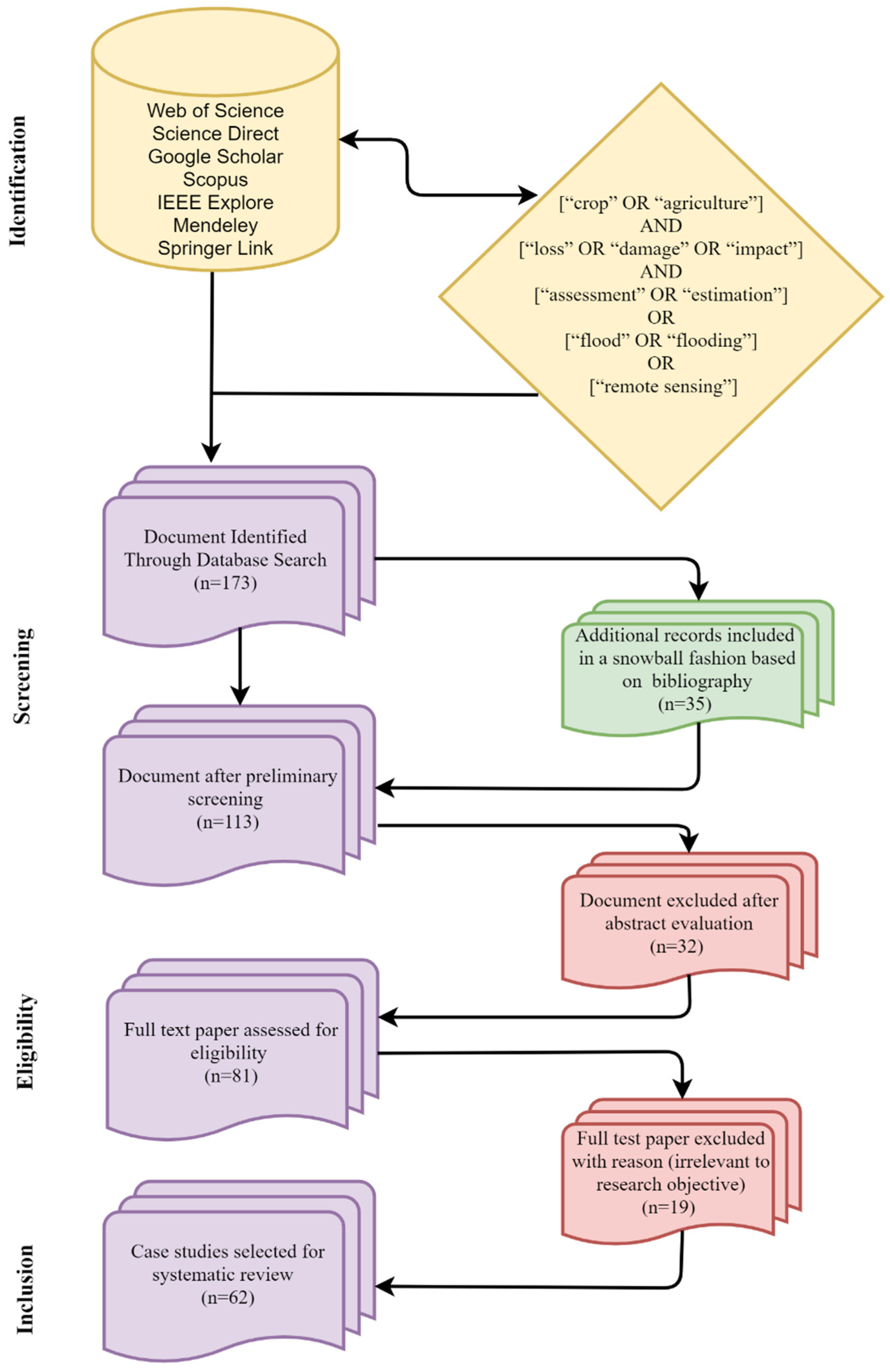
2.1. Document Search
| [“crop” OR “agriculture”] |
| AND |
| [“loss” OR “damage” OR “impact”] |
| AND |
| [“assessment” OR “estimation”] |
| OR |
| [“flood” OR “flooding”] |
| OR |
| [“remote sensing”]. |
2.2. Document Screening and Categorization Process
2.3. Data Analysis and Interpretation
3. Results
3.1. Remote Sensing Data Utilization
3.2. Remote-Sensing-Based Flood Crop Loss Assessment Approaches
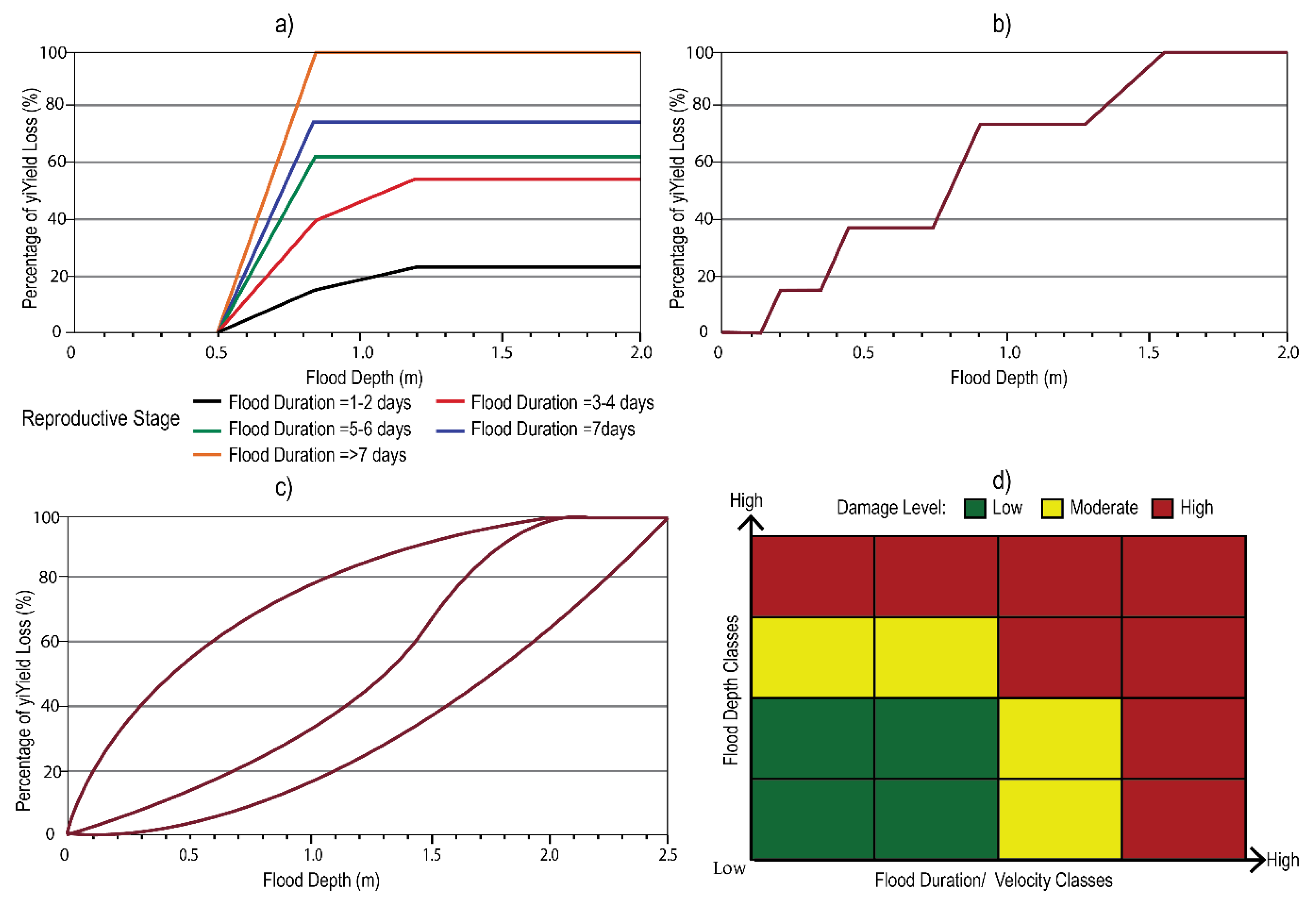
3.2.1. Flood-Intensity-Based Crop Loss Assessment
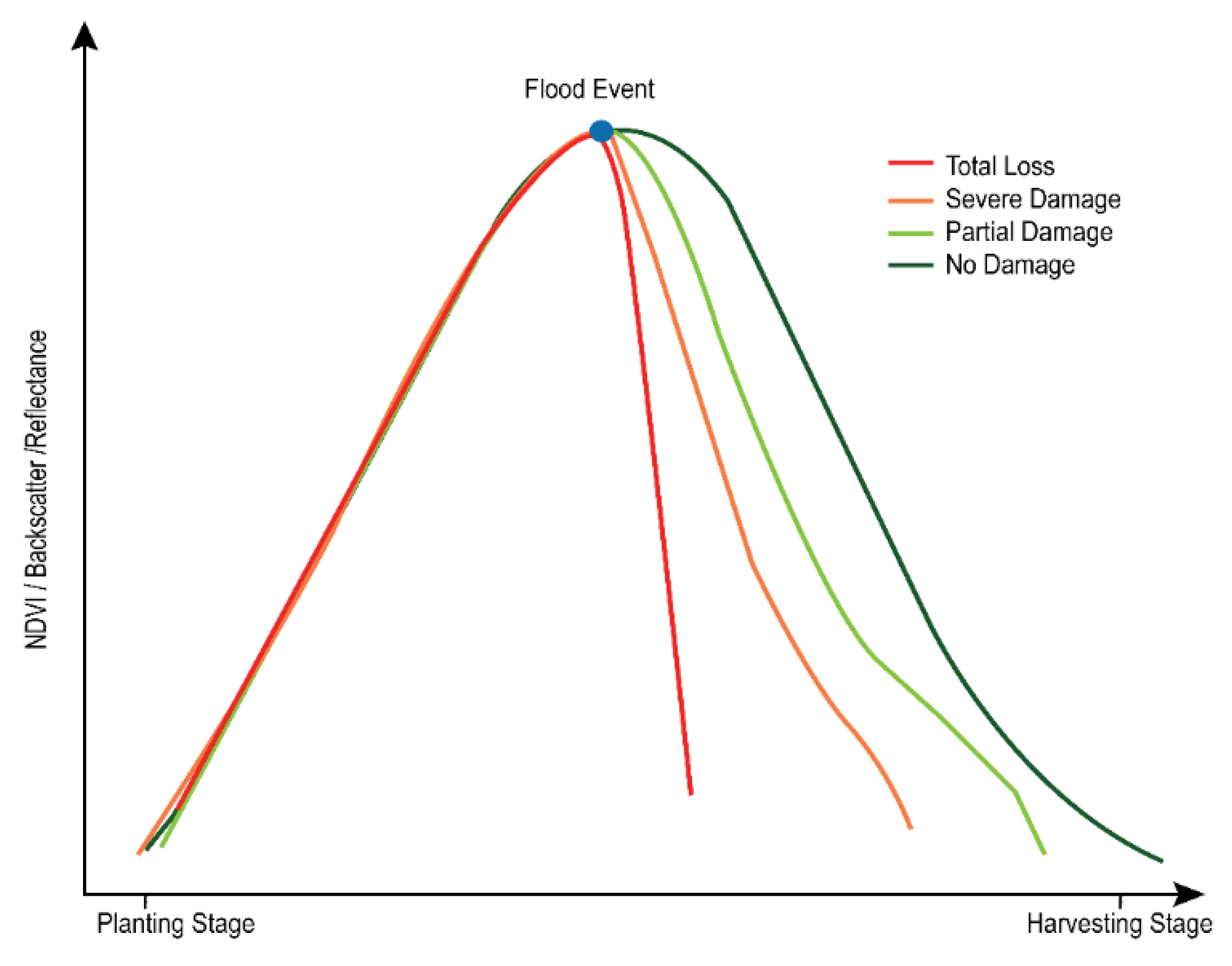
3.2.2. Crop-Condition-Based Crop Loss Assessment
3.2.3. Combined Utilization of Flood Information and Crop Condition Profile
3.2.4. Model-Based Crop Loss Assessment
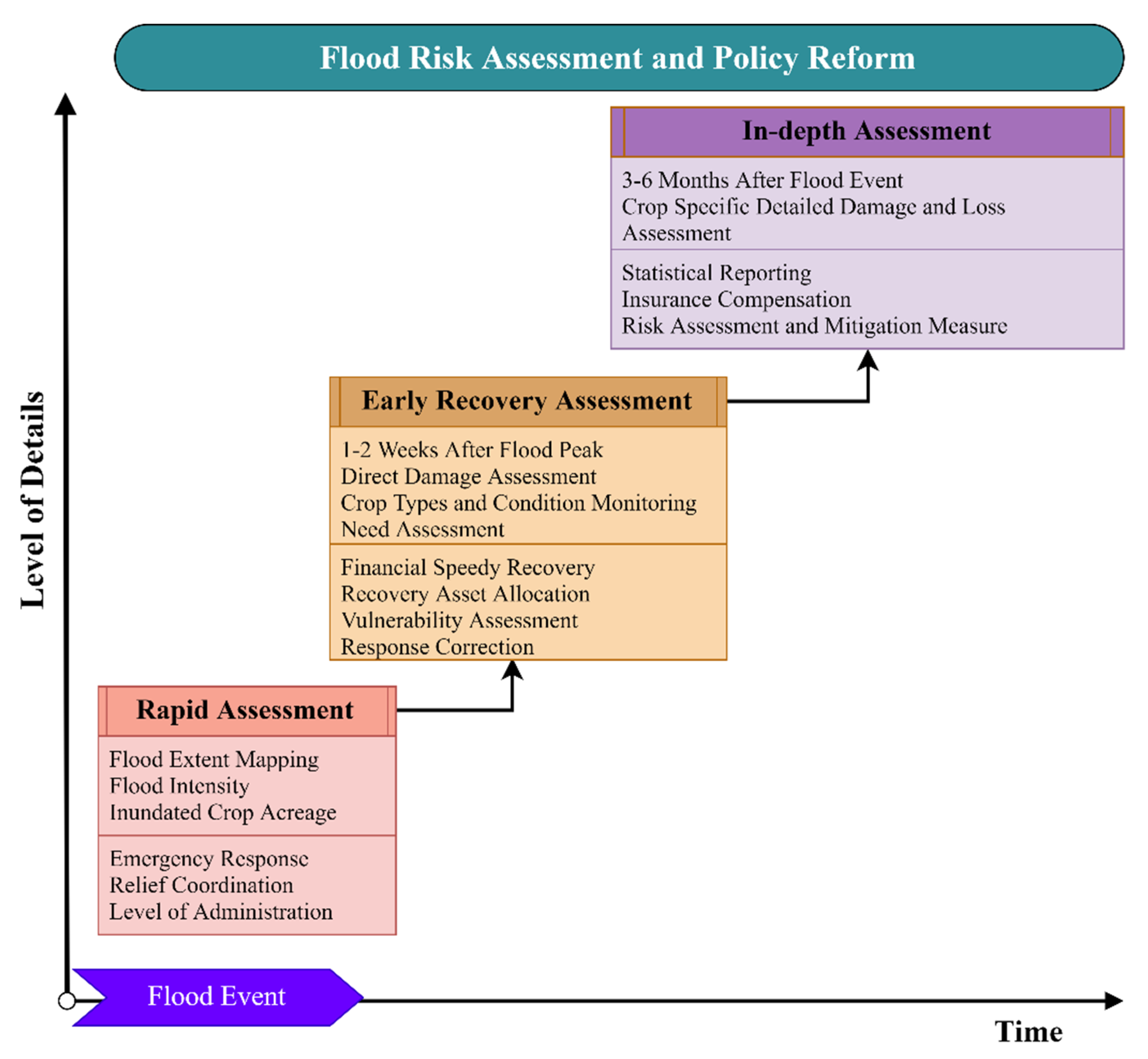
3.3. Flood Crop Damage Reporting Indicators
3.4. Approaches for the Validation of Loss Assessment
3.5. Web Service Systems for Flood Crop Loss Assessment
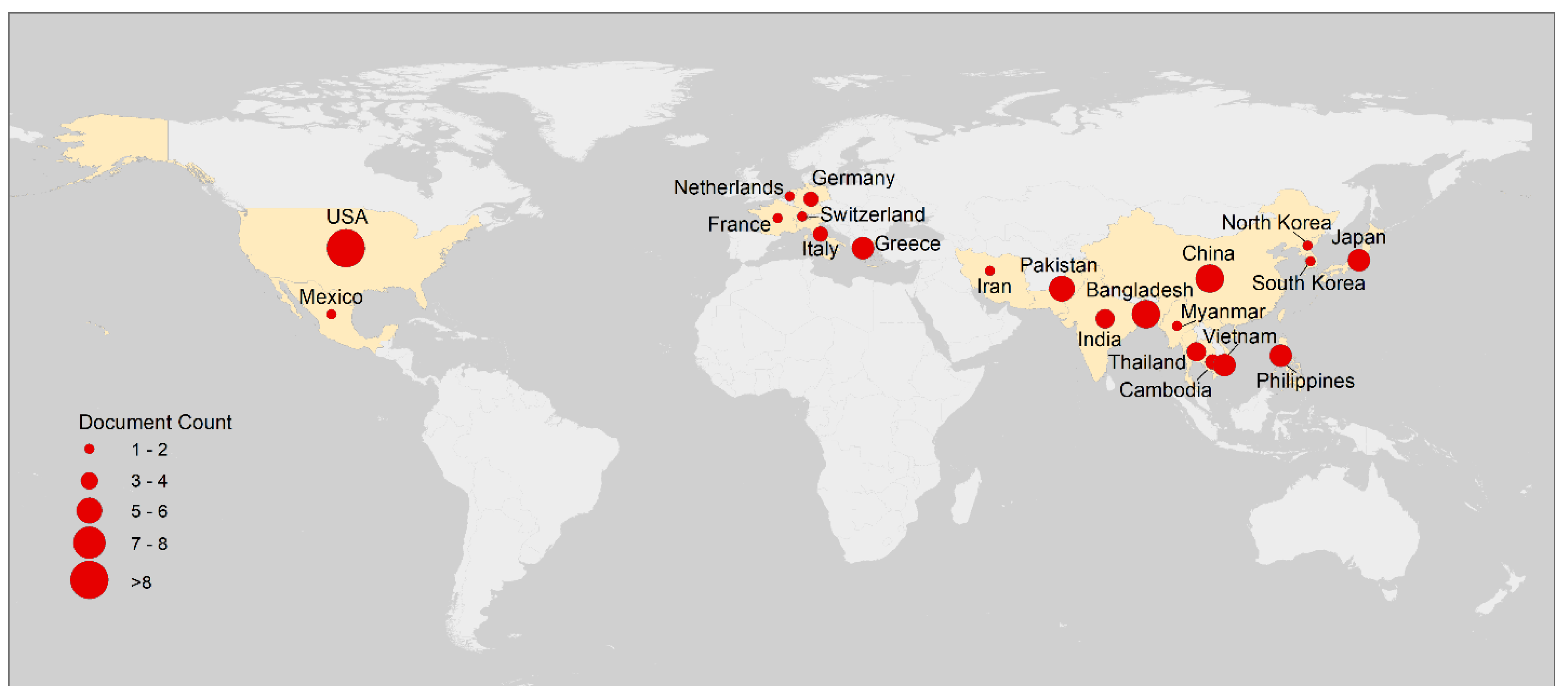
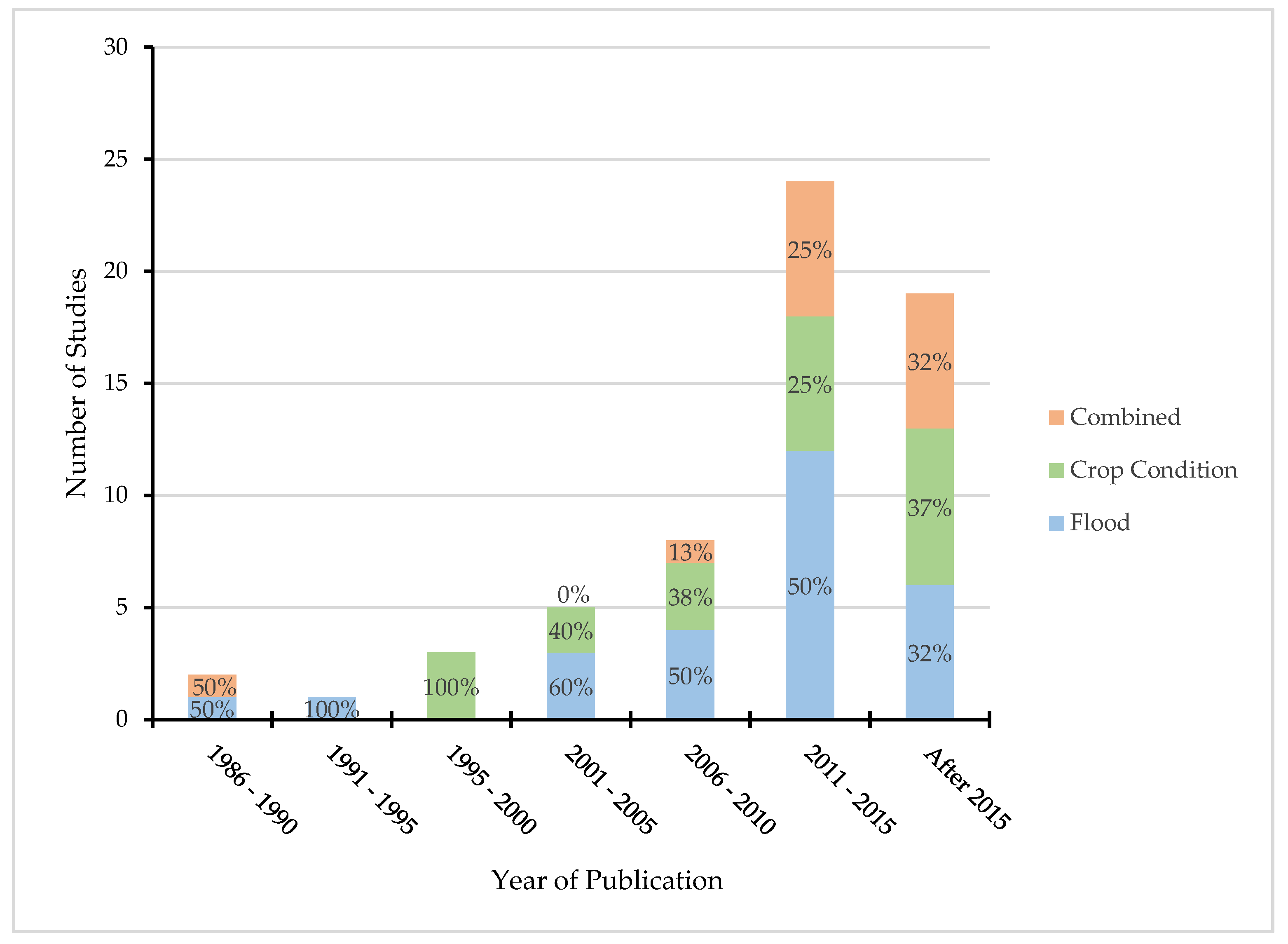
3.6. Spatiotemporal Distribution of Case Study Research
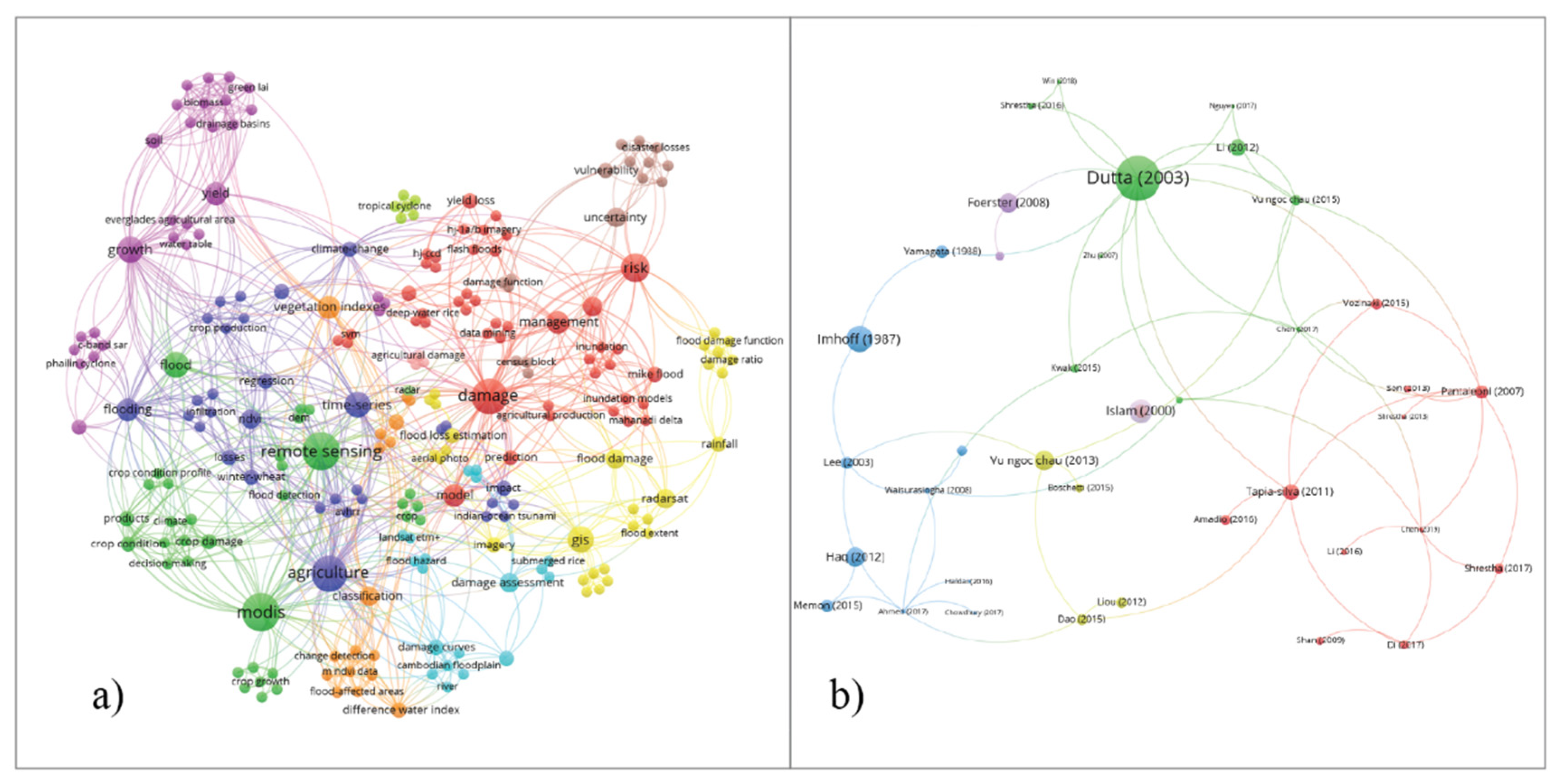
3.7. Summary of Literature Sources, Keywords, and Citations
4. Discussion
5. Conclusions
Author Contributions
Funding
Acknowledgments
Conflicts of Interest
References
- FAO. The Impact of Disasters on Agriculture and Food Security; Food and Agriculture Organization of the United Nations: Rome, Italy, 2015. [Google Scholar]
- Chen, H.; Liang, Q.; Liang, Z.; Liu, Y.; Xie, S. Remote-sensing disturbance detection index to identify spatio-temporal varying flood impact on crop production. Agric. For. Meteorol. 2019, 269, 180–191. [Google Scholar] [CrossRef]
- Aerts, J.C.; Botzen, W.W. Climate change impacts on pricing long-term flood insurance: A comprehensive study for the Netherlands. Glob. Environ. Chang. 2011, 21, 1045–1060. [Google Scholar] [CrossRef]
- Bouwer, L.M. Have disaster losses increased due to anthropogenic climate change? Bull. Am. Meteorol. Soc. 2011, 92, 39–46. [Google Scholar] [CrossRef]
- Field, C.B.; Barros, V.; Stocker, T.F.; Dahe, Q. Managing the Risks of Extreme Events and Disasters to Advance Climate Change Adaptation: Special Report of the Intergovernmental Panel on Climate Change; Cambridge University Press: Cambridge, UK, 2012. [Google Scholar]
- Hirabayashi, Y.; Mahendran, R.; Koirala, S.; Konoshima, L.; Yamazaki, D.; Watanabe, S.; Kim, H.; Kanae, S. Global flood risk under climate change. Nat. Clim. Chang. 2013, 3, 816–821. [Google Scholar] [CrossRef]
- Rahman, M.S.; Di, L.; Eugene, G.Y.; Tang, J.; Lin, L.; Zhang, C.; Yu, Z.; Gaigalas, J. Impact of Climate Change on Soil Salinity: A remote sensing based investigation in Coastal Bangladesh. In Proceedings of the 2018 7th International Conference on Agro-Geoinformatics, Zhejiang University, Hangzhou, China, 6–9 August 2018; pp. 1–5. [Google Scholar]
- Brémond, P.; Grelot, F.; Agenais, A.-L. Economic evaluation of flood damage to agriculture – review and analysis of existing methods. Nat. Hazards Earth Syst. Sci. 2013, 13, 2493–2512. [Google Scholar] [CrossRef]
- Adnan, M.S.G.; Haque, A.; Hall, J.W. Have coastal embankments reduced flooding in Bangladesh? Sci. Total Environ. 2019, 682, 405–416. [Google Scholar] [CrossRef]
- Gerl, T.; Kreibich, H.; Franco, G.; Marechal, D.; Schröter, K. A review of flood loss models as basis for harmonization and benchmarking. PLoS ONE 2016, 11, e0159791. [Google Scholar] [CrossRef]
- Merz, B.; Kreibich, H.; Schwarze, R.; Thieken, A. Review article” Assessment of economic flood damage”. Nat. Hazards Earth Syst. Sci. 2010, 10, 1697–1724. [Google Scholar] [CrossRef]
- Amadio, M.; Mysiak, J.; Carrera, L.; Koks, E. Improving flood damage assessment models in Italy. Nat. Hazards 2016, 82, 2075–2088. [Google Scholar] [CrossRef]
- Shrestha, B.B.; Sawano, H.; Ohara, M.; Yamazaki, Y.; Tokunaga, Y. Methodology for agricultural flood damage assessment. In Recent Advances in Flood Risk Management; Abbot, J., Hammond, A., Eds.; IntechOpen: London, UK, 2019. [Google Scholar]
- Mao, G.; Onfroy, T.; Moncoulon, D.; Quantin, A.; Robert, C. Comprehensive flood economic losses: Review of the potential damage and implementation of an agricultural impact model. In Proceedings of the 3rd European Conference on Flood Risk Management, Lyon, France, 20 October 2016; Volume 7, p. 05003. [Google Scholar]
- Ahmed, M.; Rahaman, K.; Kok, A.; Hassan, Q. Remote Sensing-Based Quantification of the Impact of Flash Flooding on the Rice Production: A Case Study over Northeastern Bangladesh. Sensors 2017, 17, 2347. [Google Scholar] [CrossRef]
- Shrestha, R.; Di, L.; Yu, E.G.; Kang, L.; Shao, Y.; Bai, Y. Regression model to estimate flood impact on corn yield using MODIS NDVI and USDA cropland data layer. J. Integr. Agric. 2017, 16, 398–407. [Google Scholar] [CrossRef]
- Di, L.; Yu, E.G.; Kang, L.; Shrestha, R.; Bai, Y. RF-CLASS: A remote-sensing-based flood crop loss assessment cyber-service system for supporting crop statistics and insurance decision-making. J. Integr. Agric. 2017, 16, 408–423. [Google Scholar] [CrossRef]
- WMO. Conducting Flood Loss Assessment—A Tool for Integrated Flood Management; Integrated Flood Management Tool Series; World Meteorological Organization (WMO) and the Global Water Partnership (GWP): Brisbane, Australia, 2007. [Google Scholar]
- Mosleh, M.K.; Hassan, Q.K.; Chowdhury, E.H. Application of remote sensors in mapping rice area and forecasting its production: A review. Sensors 2015, 15, 769–791. [Google Scholar] [CrossRef]
- Qian, Y.; Yang, Z.; Di, L.; Rahman, M.; Tan, Z.; Xue, L.; Gao, F.; Yu, E.G.; Zhang, X. Crop Growth Condition Assessment at County Scale Based on Heat-Aligned Growth Stages. Remote Sens. 2019, 11, 2439. [Google Scholar] [CrossRef]
- Yu, G.; Di, L.; Zhang, B.; Shao, Y.; Shrestha, R.; Kang, L. Remote-sensing-based flood damage estimation using crop condition profiles. In Proceedings of the Second International Conference on Agro-Geoinformatics, Fairfax, VA, USA, 12–16 August 2013; pp. 205–210. [Google Scholar]
- Rahman, M.S.; Di, L. The state of the art of spaceborne remote sensing in flood management. Nat. Hazards 2017, 85, 1223–1248. [Google Scholar] [CrossRef]
- Smith, D.I. Flood damage estimation—A review of urban stage-damage curves and loss functions. Water Sa 1994, 20, 231–238. [Google Scholar]
- Olesen, L.; Löwe, R.; Arnbjerg-Nielsen, K. Flood Damage Assessment–Literature Review and Recommended Procedure; Cooperative Research Centre for Water Sensitive Cities: Melbourne, Australia, March 2017. [Google Scholar]
- Pickering, C.; Byrne, J. The benefits of publishing systematic quantitative literature reviews for PhD candidates and other early-career researchers. High. Educ. Res. Dev. 2014, 33, 534–548. [Google Scholar] [CrossRef]
- Hamel, R.E. The dominance of English in the international scientific periodical literature and the future of language use in science. Aila Rev. 2007, 20, 53–71. [Google Scholar] [CrossRef]
- Van Eck, N.J.; Waltman, L. VOSviewer manual. Leiden Univeristeit Leiden 2013, 1, 1–53. [Google Scholar]
- Van Eck, N.J.; Waltman, L. Citation-based clustering of publications using CitNetExplorer and VOSviewer. Scientometrics 2017, 111, 1053–1070. [Google Scholar] [CrossRef]
- Forte, F.; Strobl, R.O.; Pennetta, L. A methodology using GIS, aerial photos and remote sensing for loss estimation and flood vulnerability analysis in the Supersano-Ruffano-Nociglia Graben, southern Italy. Environ. Geol. 2006, 50, 581–594. [Google Scholar] [CrossRef]
- Waisurasingha, C.; Aniya, M.; Hirano, A.; Sommut, W. Use of RADARSAT-1 data and a digital elevation model to assess flood damage and improve rice production in the lower part of the Chi River Basin, Thailand. Int. J. Remote Sens. 2008, 29, 5837–5850. [Google Scholar] [CrossRef]
- Li, S.; Tompkins, A.M.; Lin, E.; Ju, H. Simulating the impact of flooding on wheat yield—Case study in East China. Agric. For. Meteorol. 2016, 216, 221–231. [Google Scholar] [CrossRef]
- Hossain, A.K.M.A. Flood inundation and crop damage mapping: A method for modeling the impact on rural income and migration in humid deltas. In Climate Vulnerability; Elsevier: Amsterdam, The Netherlands, 2013; pp. 357–374. [Google Scholar]
- Dao, P.; Liou, Y.-A. Object-based flood mapping and affected rice field estimation with Landsat 8 OLI and MODIS data. Remote Sens. 2015, 7, 5077–5097. [Google Scholar] [CrossRef]
- Ma, Y.; Liu, X.; Li, X.; Sun, Y.; Li, X. Rapid assessment of flood disaster loss in Sind and Punjab province, Pakistan based on RS and GIS. In Proceedings of the International Conference on Multimedia Technology, Hangzhou, China, 26–28 July 2011; pp. 646–649. [Google Scholar]
- Chen, H.; Liang, Z.; Liu, Y.; Liang, Q.; Xie, S. Integrated remote sensing imagery and two-dimensional hydraulic modeling approach for impact evaluation of flood on crop yields. J. Hydrol. 2017, 553, 262–275. [Google Scholar] [CrossRef]
- Gu, X.; Xu, P.; Wang, L.; Wang, X. Evaluation of Crop Yield Loss of Floods Based on Water Turbidity Index with Multi-Temporal HJ-CCD Images. In Proceedings of the SPIE 9815, MIPPR 2015: Remote Sensing Image Processing, Geographic Information Systems, and Other Applications, Enshi, China, 14 December 2015; p. 98150D. [Google Scholar]
- Haldar, D.; Nigam, R.; Patnaik, C.; Dutta, S.; Bhattacharya, B. Remote sensing-based assessment of impact of Phailin cyclone on rice in Odisha, India. Paddy Water Environ. 2016, 14, 451–461. [Google Scholar] [CrossRef]
- Adnan, M.S.G.; Dewan, A.; Zannat, K.E.; Abdullah, A.Y.M. The use of watershed geomorphic data in flash flood susceptibility zoning: A case study of the Karnaphuli and Sangu river basins of Bangladesh. Nat. Hazards 2019, 99, 425–448. [Google Scholar] [CrossRef]
- Chejarla, V.R.; Mandla, V.R.; Palanisamy, G.; Choudhary, M. Estimation of damage to agriculture biomass due to Hudhud cyclone and carbon stock assessment in cyclone affected areas using Landsat-8. Geocarto Int. 2017, 32, 589–602. [Google Scholar] [CrossRef]
- Liou, Y.-A.; Sha, H.-C.; Chen, T.-M.; Wang, T.-S.; Li, Y.-T.; Lai, Y.-C.; Chiang, M.-H.; Lu, L.-T. Assessment of Disaster Losses in Rice Paddy Field and Yield after Tsunami Induced by the 2011 Great East Japan Earthquake. J. Mar. Sci. Technol. 2012, 20, 618–623. [Google Scholar]
- Tapia-Silva, F.-O.; Itzerott, S.; Foerster, S.; Kuhlmann, B.; Kreibich, H. Estimation of flood losses to agricultural crops using remote sensing. Phys. Chem. Earth Parts ABC 2011, 36, 253–265. [Google Scholar] [CrossRef]
- Yamagata, Y.; Akiyama, T. Flood damage analysis using multitemporal Landsat Thematic Mapper data. Int. J. Remote Sens. 1988, 9, 503–514. [Google Scholar] [CrossRef]
- Rahman, M.S.; Di, L.; Yu, E.; Zhang, C.; Mohiuddin, H. In-Season Major Crop-Type Identification for US Cropland from Landsat Images Using Crop-Rotation Pattern and Progressive Data Classification. Agriculture 2019, 9, 17. [Google Scholar] [CrossRef]
- Liu, W.; Huang, J.; Wei, C.; Wang, X.; Mansaray, L.R.; Han, J.; Zhang, D.; Chen, Y. Mapping water-logging damage on winter wheat at parcel level using high spatial resolution satellite data. ISPRS J. Photogramm. Remote Sens. 2018, 142, 243–256. [Google Scholar] [CrossRef]
- Capellades, M.A.; Reigber, S.; Kunze, M. Storm Damage Assessment Support Service in the U.S. Corn belt Using RapidEye Satellite Imagery. In Proceedings of the SPIE 7472, Remote Sensing for Agriculture, Ecosystems, and Hydrology XI, Berlin, Germany, 18 September 2009; p. 747208. [Google Scholar]
- Silleos, N.; Perakis, K.; Petsanis, G. Assessment of crop damage using space remote sensing and GIS. Int. J. Remote Sens. 2002, 23, 417–427. [Google Scholar] [CrossRef]
- Del Carmen Silva-Aguila, N.; López-Caloca, A.; Silván-Cárdenas, J.L. Damage Estimation on Agricultural Crops by a Flood. In Proceedings of the SPIE 8174, Remote Sensing for Agriculture, Ecosystems, and Hydrology XIII, Prague, Czech Republic, 6 October 2011; p. 81740D. [Google Scholar]
- Dutta, D.; Herath, S. GIS based flood loss estimation modeling in Japan. In Proceedings of the US-Japan 1st Workshop on Comparative Study on Urban Disaster Management, Port Island, Kobe, Japan, 2011; pp. 151–161. Available online: https://iwhw.boku.ac.at/floodforecast/references/methods/dushmantadutta.pdf (accessed on 15 April 2020).
- Van der Sande, C.J.; De Jong, S.M.; De Roo, A.P.J. A segmentation and classification approach of IKONOS-2 imagery for land cover mapping to assist flood risk and flood damage assessment. Int. J. Appl. Earth Obs. Geoinfor. 2003, 4, 217–229. [Google Scholar] [CrossRef]
- Shan, J.; Hussain, E.; Kim, K.; Biehl, L. Flood mapping and damage assessment—A case study in the state of Indiana. In Geospatial Technology for Earth Observation; Li, D., Shan, J., Gong, J., Eds.; Springer: Boston, MA, USA, 2010; pp. 473–495. [Google Scholar]
- Shrestha, R.; Di, L.; Yu, G.; Shao, Y.; Kang, L.; Zhang, B. Detection of flood and its impact on crops using NDVI-Corn case. In Proceedings of the Second International Conference on Agro-Geoinformatics, Fairfax, VA, USA, 12–16 August 2013; pp. 200–204. [Google Scholar]
- Zhang, B.; Di, L.; Yu, G.; Shao, Y.; Shrestha, R.; Kang, L. A Web service based application serving vegetation condition indices for Flood Crop Loss Assessment. In Proceedings of the Second International Conference on Agro-Geoinformatics, Fairfax, VA, USA, 12–16 August 2013; pp. 215–220. [Google Scholar]
- Boryan, C.; Yang, Z.; Mueller, R.; Craig, M. Monitoring US agriculture: The US department of agriculture, national agricultural statistics service, cropland data layer program. Geocarto Int. 2011, 26, 341–358. [Google Scholar] [CrossRef]
- Boschetti, M.; Nelson, A.; Nutini, F.; Manfron, G.; Busetto, L.; Barbieri, M.; Laborte, A.; Raviz, J.; Holecz, F.; Mabalay, M.; et al. Rapid Assessment of Crop Status: An Application of MODIS and SAR Data to Rice Areas in Leyte, Philippines Affected by Typhoon Haiyan. Remote Sens. 2015, 7, 6535–6557. [Google Scholar] [CrossRef]
- Lin, L.; Di, L.; Tang, J.; Yu, E.; Zhang, C.; Rahman, M.; Shrestha, R.; Kang, L. Improvement and Validation of NASA/MODIS NRT Global Flood Mapping. Remote Sens. 2019, 11, 205. [Google Scholar] [CrossRef]
- Lin, L.; Di, L.; Yu, E.G.; Tang, J.; Shrestha, R.; Rahman, M.S.; Kang, L.; Sun, Z.; Zhang, C.; Hu, L. Extract flood duration from Dartmouth Flood Observatory flood product. In Proceedings of the 6th International Conference on the Agro-Geoinformatics, Fairfax, VA, USA, 7–10 August 2017; pp. 1–4. [Google Scholar]
- Lee, K.S.; Lee, S.I. Assessment of post-flooding conditions of rice fields with multi-temporal satellite SAR data. Int. J. Remote Sens. 2003, 24, 3457–3465. [Google Scholar] [CrossRef]
- Rahman, M.S.; Di, L.; Yu, E.; Lin, L.; Zhang, C.; Tang, J. Rapid flood progress monitoring in cropland with NASA SMAP. Remote Sens. 2019, 11, 191. [Google Scholar] [CrossRef]
- Li, K.; Wu, S.; Dai, E.; Xu, Z. Flood loss analysis and quantitative risk assessment in China. Nat. Hazards 2012, 63, 737–760. [Google Scholar] [CrossRef]
- Chau, V.N.; Cassells, S.; Holland, J. Economic impact upon agricultural production from extreme flood events in Quang Nam, central Vietnam. Nat. Hazards 2015, 75, 1747–1765. [Google Scholar] [CrossRef]
- Dutta, D.; Herath, S.; Musiake, K. A mathematical model for flood loss estimation. J. Hydrol. 2003, 277, 24–49. [Google Scholar] [CrossRef]
- Samantaray, D.; Chatterjee, C.; Singh, R.; Gupta, P.K.; Panigrahy, S. Flood risk modeling for optimal rice planning for delta region of Mahanadi river basin in India. Nat. Hazards 2015, 76, 347–372. [Google Scholar] [CrossRef]
- Pacetti, T.; Caporali, E.; Rulli, M.C. Floods and food security: A method to estimate the effect of inundation on crops availability. Adv. Water Resour. 2017, 110, 494–504. [Google Scholar] [CrossRef]
- Kwak, Y.; Shrestha, B.B.; Yorozuya, A.; Sawano, H. Rapid damage assessment of rice crop after large-scale flood in the cambodian floodplain using temporal spatial data. IEEE J. Sel. Top. Appl. Earth Obs. Remote Sens. 2015, 8, 3700–3709. [Google Scholar] [CrossRef]
- Förster, S.; Kuhlmann, B.; Lindenschmidt, K.-E.; Bronstert, A. Assessing flood risk for a rural detention area. Nat. Hazards Earth Syst. Sci. 2008, 8, 311–322. [Google Scholar] [CrossRef]
- Shrestha, B.B.; Okazumi, T.; Miyamoto, M.; Sawano, H. Flood damage assessment in the Pampanga river basin of the Philippines: Flood damage assessment in Pampanga river basin. J. Flood Risk Manag. 2016, 9, 355–369. [Google Scholar] [CrossRef]
- Citeau, J.M. A new control concept in the Oise catchment area: Definition and assessment of flood compatible agricultural activities. In Proceedings of the FIG Working Week, Paris, France, 13–17 April 2003. [Google Scholar]
- Win, S.; Zin, W.W.; Kawasaki, A.; San, Z.M.L.T. Establishment of flood damage function models: A case study in the Bago River Basin, Myanmar. Int. J. Disaster Risk Reduct. 2018, 28, 688–700. [Google Scholar] [CrossRef]
- Consuegra, D.; Joerin, F.; Vitalini, F. Flood Delineation and Impact Assessment in Agricultural Land Using GIS Technology. In Geographical Information Systems in Assessing Natural Hazards; Carrara, A., Guzzetti, F., Eds.; Springer: Dordrecht, The Netherlands, 1995; Volume 5, pp. 177–198. [Google Scholar]
- Vozinaki, A.-E.K.; Karatzas, G.P.; Sibetheros, I.A.; Varouchakis, E.A. An agricultural flash flood loss estimation methodology: The case study of the Koiliaris basin (Greece), February 2003 flood. Nat. Hazards 2015, 79, 899–920. [Google Scholar] [CrossRef]
- Chau, V.N.; Cassells, S.M.; Holland, J. Measuring Direct Losses to Rice Production from Extreme Flood Events in Quang Nam Province, Vietnam. In Proceedings of the 58th Conference of Australian Agricultural and Resource Economics Society, Port Macquarie, Australia, 4–7 February 2014. [Google Scholar]
- Imhoff, M.L.; Vermillion, C.; Story, M.H.; Choudhury, A.M.; Gafoor, A.; Polcyn, F. Monsoon flood boundary delineation and damage assessment using space borne imaging radar and Landsat data. Photogramm. Eng. Remote Sens. 1987, 53, 405–413. [Google Scholar]
- Pistrika, A. Flood damage estimation based on flood simulation scenarios and a GIS platform. Eur. Water 2010, 30, 3–11. [Google Scholar]
- Qi, H.; Altinakar, M.S. Simulation-based decision support system for flood damage assessment under uncertainty using remote sensing and census block information. Nat. Hazards 2011, 59, 1125–1143. [Google Scholar] [CrossRef]
- Haq, M.; Akhtar, M.; Muhammad, S.; Paras, S.; Rahmatullah, J. Techniques of remote sensing and GIS for flood monitoring and damage assessment: A case study of Sindh province, Pakistan. Egypt. J. Remote Sens. Space Sci. 2012, 15, 135–141. [Google Scholar] [CrossRef]
- Chau, V.N.; Holland, J.; Cassells, S.; Tuohy, M. Using GIS to map impacts upon agriculture from extreme floods in Vietnam. Appl. Geogr. 2013, 41, 65–74. [Google Scholar] [CrossRef]
- Memon, A.A.; Muhammad, S.; Rahman, S.; Haq, M. Flood monitoring and damage assessment using water indices: A case study of Pakistan flood-2012. Egypt. J. Remote Sens. Space Sci. 2015, 18, 99–106. [Google Scholar] [CrossRef]
- Nguyen, N.Y.; Ichikawa, Y.; Ishidaira, H. Establishing flood damage functions for agricultural crops using estimated inundation depth and flood disaster statistics in data-scarce regions. Hydrol. Res. Lett. 2017, 11, 12–18. [Google Scholar] [CrossRef]
- Shokoohi, A.; Ganji, Z.; Samani, J.M.V.; Singh, V.P. Analysis of spatial and temporal risk of agricultural loss due to flooding in paddy farms. Paddy Water Environ. 2018, 16, 737–748. [Google Scholar] [CrossRef]
- Okamoto, K.; Yamakawa, S.; Kawashima, H. Estimation of flood damage to rice production in North Korea in 1995. Int. J. Remote Sens. 1998, 19, 365–371. [Google Scholar] [CrossRef]
- Shrestha, R.; Di, L.; Eugene, G.Y.; Kang, L.; Li, L.; Rahman, M.S.; Deng, M.; Yang, Z. Regression based corn yield assessment using MODIS based daily NDVI in Iowa state. In Proceedings of the Fifth International Conference on Agro-Geoinformatics, Tianjin, China, 18–20 July 2016; pp. 1–5. [Google Scholar]
- Shrestha, R.; Di, L.; Eugene, G.Y.; Rahman, M.S.; Lin, L.; Hu, L.; Tang, J. Crop Fraction Layer (CFL) datasets derived through MODIS and LandSat for the Continental US from year 2000–2016. In Proceedings of the 6th International Conference on Agro-Geoinformatics, Fairfax, VA, USA, 7–10 August 2017; pp. 1–7. [Google Scholar]
- Gilbert, R.A.; Rainbolt, C.R.; Morris, D.R.; McCray, J.M. Sugarcane growth and yield responses to a 3-month summer flood. Agric. Water Manag. 2008, 95, 283–291. [Google Scholar] [CrossRef]
- Islam, M.M.; Sado, K. Flood hazard assessment in Bangladesh using NOAA AVHRR data with geographical information system. Hydrol. Process. 2000, 14, 605–620. [Google Scholar] [CrossRef]
- Rouse, J., Jr.; Haas, R.H.; Schell, J.A.; Deering, D.W. Monitoring vegetation systems in the Great Plains with ERTS. NASA Spec. Publ. 1974, 351, 309. [Google Scholar]
- Pantaleoni, E.; Engel, B.A.; Johannsen, C.J. Identifying agricultural flood damage using Landsat imagery. Precis. Agric. 2007, 8, 27–36. [Google Scholar] [CrossRef]
- Huete, A.; Didan, K.; Miura, T.; Rodriguez, E.P.; Gao, X.; Ferreira, L.G. Overview of the radiometric and biophysical performance of the MODIS vegetation indices. Remote Sens. Environ. 2002, 83, 195–213. [Google Scholar] [CrossRef]
- Kotera, A.; Nagano, T.; Hanittinan, P.; Koontanakulvong, S. Assessing the degree of flood damage to rice crops in the Chao Phraya delta, Thailand, using MODIS satellite imaging. Paddy Water Environ. 2016, 14, 271–280. [Google Scholar] [CrossRef]
- Son, N.T.; Chen, C.F.; Chen, C.R.; Chang, L.Y. Satellite-based investigation of flood-affected rice cultivation areas in Chao Phraya River Delta, Thailand. ISPRS J. Photogramm. Remote Sens. 2013, 86, 77–88. [Google Scholar] [CrossRef]
- Jiang, Z.; Huete, A.R.; Didan, K.; Miura, T. Development of a two-band enhanced vegetation index without a blue band. Remote Sens. Environ. 2008, 112, 3833–3845. [Google Scholar] [CrossRef]
- Chandrasekar, K.; Sesha Sai, M.V.R.; Roy, P.S.; Dwevedi, R.S. Land Surface Water Index (LSWI) response to rainfall and NDVI using the MODIS Vegetation Index product. Int. J. Remote Sens. 2010, 31, 3987–4005. [Google Scholar] [CrossRef]
- Huete, A.R. A soil-adjusted vegetation index (SAVI). Remote Sens. Environ. 1988, 25, 295–309. [Google Scholar] [CrossRef]
- Rondeaux, G.; Steven, M.; Baret, F. Optimization of soil-adjusted vegetation indices. Remote Sens. Environ. 1996, 55, 95–107. [Google Scholar] [CrossRef]
- Tucker, C.J. Red and photographic infrared linear combinations for monitoring vegetation. Remote Sens. Environ. 1979, 8, 127–150. [Google Scholar] [CrossRef]
- Haboudane, D.; Miller, J.R.; Pattey, E.; Zarco-Tejada, P.J.; Strachan, I.B. Hyperspectral vegetation indices and novel algorithms for predicting green LAI of crop canopies: Modeling and validation in the context of precision agriculture. Remote Sens. Environ. 2004, 90, 337–352. [Google Scholar] [CrossRef]
- Buschmann, C.; Nagel, E. In vivo spectroscopy and internal optics of leaves as basis for remote sensing of vegetation. Int. J. Remote Sens. 1993, 14, 711–722. [Google Scholar] [CrossRef]
- Kogan, F.N. Droughts of the late 1980s in the United States as derived from NOAA polar-orbiting satellite data. Bull. Am. Meteorol. Soc. 1995, 76, 655–668. [Google Scholar] [CrossRef]
- Yang, Z.; Di, L.; Yu, G.; Chen, Z. Vegetation condition indices for crop vegetation condition monitoring. In Proceedings of the 2011 IEEE International Geoscience and Remote Sensing Symposium, Sendai, Japan, 1–5 August 2011; pp. 3534–3537. [Google Scholar]
- Xiao, X.; Boles, S.; Liu, J.; Zhuang, D.; Frolking, S.; Li, C.; Salas, W.; Moore, B., III. Mapping paddy rice agriculture in southern China using multi-temporal MODIS images. Remote Sens. Environ. 2005, 95, 480–492. [Google Scholar] [CrossRef]
- Di, L.; Yu, E.; Shrestha, R.; Lin, L. DVDI: A new remotely sensed index for measuring vegetation damage caused by natural disasters. In Proceedings of the IGARSS 2018 IEEE International Geoscience and Remote Sensing Symposium, Valencia, Spain, 22–27 July 2018; pp. 9067–9069. [Google Scholar]
- Di, S.; Guo, L.; Lin, L. Rapid estimation of flood crop loss by using DVDI. In Proceedings of the 7th International Conference on Agro-Geoinformatics, Hangzhou, China, 6–9 August 2018; pp. 1–4. [Google Scholar]
- Chowdhury, E.H.; Hassan, Q.K. Use of remote sensing data in comprehending an extremely unusual flooding event over southwest Bangladesh. Nat. Hazards 2017, 88, 1805–1823. [Google Scholar] [CrossRef]
- Shrestha, B.B.; Sawano, H.; Ohara, M.; Nagumo, N. Improvement in flood disaster damage assessment using highly accurate IfSAR DEM (Special Issue: An Approach to Next-Generation Water Disaster Study: In Commemoration of the 10th Anniversary of the Establishment of ICHARM). J. Disaster Res. 2016, 11, 1137–1149. [Google Scholar] [CrossRef]
- Crow, H.A. Assessment of the FEMA HAZUS-MH 2.0 Crop Loss Tool Fremont County, Iowa 2011; University of Southern California: Los Angeles, CA, USA, 2014. [Google Scholar]
- Jongman, B.; Kreibich, H.; Apel, H.; Barredo, J.I.; Bates, P.D.; Feyen, L.; Gericke, A.; Neal, J.; Aerts, J.; Ward, P.J. Comparative flood damage model assessment: Towards a European approach. Nat. Hazards Earth Syst. Sci. 2012, 12, 3733–3752. [Google Scholar] [CrossRef]
- Scawthorn, C.; Flores, P.; Blais, N.; Seligson, H.; Tate, E.; Chang, S.; Mifflin, E.; Thomas, W.; Murphy, J.; Jones, C. HAZUS-MH flood loss estimation methodology. II. Damage and loss assessment. Nat. Hazards Rev. 2006, 7, 72–81. [Google Scholar] [CrossRef]
- Thieken, A.H.; Ackermann, V.; Elmer, F.; Kreibich, H.; Kuhlmann, B.; Kunert, U.; Maiwald, H.; Merz, B.; Müller, M.; Piroth, K. Methods for the evaluation of direct and indirect flood losses. In Proceedings of the 4th International Symposium on Flood Defense: Managing Flood Risk, Reliability and Vulnerability, Toronto, ON, Canada, 6–8 May 2008; pp. 6–8. [Google Scholar]
- Yu, J.J.; Qin, X.S.; Larsen, O. Joint Monte Carlo and possibilistic simulation for flood damage assessment. Stoch. Environ. Res. Risk Assess. 2013, 27, 725–735. [Google Scholar] [CrossRef]
- Tsyganskaya, V.; Martinis, S.; Marzahn, P.; Ludwig, R. SAR-based detection of flooded vegetation–a review of characteristics and approaches. Int. J. Remote Sens. 2018, 39, 2255–2293. [Google Scholar] [CrossRef]
- Long, S.; Fatoyinbo, T.E.; Policelli, F. Flood extent mapping for Namibia using change detection and thresholding with SAR. Environ. Res. Lett. 2014, 9, 035002. [Google Scholar] [CrossRef]
- Martinis, S.; Rieke, C. Backscatter analysis using multi-temporal and multi-frequency SAR data in the context of flood mapping at River Saale, Germany. Remote Sens. 2015, 7, 7732–7752. [Google Scholar] [CrossRef]
- Irwin, K.; Beaulne, D.; Braun, A.; Fotopoulos, G. Fusion of SAR, optical imagery and airborne LiDAR for surface water detection. Remote Sens. 2017, 9, 890. [Google Scholar] [CrossRef]
- Ward, D.P.; Petty, A.; Setterfield, S.A.; Douglas, M.M.; Ferdinands, K.; Hamilton, S.K.; Phinn, S. Floodplain inundation and vegetation dynamics in the Alligator Rivers region (Kakadu) of northern Australia assessed using optical and radar remote sensing. Remote Sens. Environ. 2014, 147, 43–55. [Google Scholar] [CrossRef]
- Chapman, B.; McDonald, K.; Shimada, M.; Rosenqvist, A.; Schroeder, R.; Hess, L. Mapping regional inundation with spaceborne L-Band SAR. Remote Sens. 2015, 7, 5440–5470. [Google Scholar] [CrossRef]
- Evans, T.L.; Costa, M.; Telmer, K.; Silva, T.S. Using ALOS/PALSAR and RADARSAT-2 to map land cover and seasonal inundation in the Brazilian Pantanal. IEEE J. Sel. Top. Appl. Earth Obs. Remote Sens. 2010, 3, 560–575. [Google Scholar] [CrossRef]
- Rahman, M.S.; Di, L.; Yu, Z.; Eugene, G.Y.; Tang, J.; Lin, L.; Zhang, C.; Gaigalas, J. Crop Field Boundary Delineation using Historical Crop Rotation Pattern. In Proceedings of the 8th International Conference on Agro-Geoinformatics, Istanbul, Turkey, 16–19 July 2019; pp. 1–5. [Google Scholar]
- Uddin, K.; Matin, M.A.; Meyer, F.J. Operational flood mapping using multi-temporal sentinel-1 SAR images: A case study from Bangladesh. Remote Sens. 2019, 11, 1581. [Google Scholar] [CrossRef]
- Rahman, M.S.; Di, L.; Shrestha, R.; Eugene, G.Y.; Lin, L.; Zhang, C.; Hu, L.; Tang, J.; Yang, Z. Agriculture flood mapping with Soil Moisture Active Passive (SMAP) data: A case of 2016 Louisiana flood. In Proceedings of the 6th International Conference on Agro-Geoinformatics, Fairfax, VA, USA, 7–10 August 2017; pp. 1–6. [Google Scholar]
- Hu, L.; Di, L.; Yu, E.; Yue, P.; Tang, J.; Lin, L.; Zhang, C.; Sun, Z.; Hu, R.; Shrestha, R. Developing geospatial Web service and system for SMAP soil moisture monitoring. In Proceedings of the 6th International Conference on Agro-Geoinformatics, Fairfax, VA, USA, 7–10 August 2017; pp. 1–5. [Google Scholar]
- Yu, E.G.; Di, L.; Rahman, M.S.; Lin, L.; Zhang, C.; Hu, L.; Shrestha, R.; Kang, L.; Tang, J.; Yang, G. Performance improvement on a Web Geospatial service for the remote sensing flood-induced crop loss assessment web application using vector tiling. In Proceedings of the 6th International Conference on Agro-Geoinformatics, Fairfax, VA, USA, 7–10 August 2017; pp. 1–6. [Google Scholar]


| Reference, Location | Flood Extent | Flood Depth 1) | Flood Duration 1) | Flow Velocity | Seasonality | Crop-Specific 1) |
|---|---|---|---|---|---|---|
| Imhoff et al. [72], Bangladesh | Yes | No | No | No | No | No |
| Consuegra et al. [69], Switzerland | Yes | No | Yes—days (three classes) | no | Yes—a period of 15 days | No |
| del Carmen Silva-Aguila et al. [47], Mexico | Yes | Yes—four classes | No | No | No | No |
| Dutta and Herath [48], Japan | Yes | Yes—four classes | Yes—hourly | No | No | Yes—eight classes |
| Dutta et al. [61], Japan | Yes | Yes—three classes | Yes—days | No | Yes—monthly | Yes—eight classes |
| van der Sande et al. [49], the Netherlands | Yes | Yes—damage curve | No | No | No | Yes—wheat |
| Forte et al. [29], Italy | Yes | Yes—damage curve | No | No | No | No |
| Waisurasingha et al. [30], Thailand | Yes | Yes—80 cm threshold | No | No | No | No |
| Förster et al. [65], Germany | Yes | No | Yes—four classes | No | Yes—monthly | Yes—multi crop |
| Pistrika [73], Greece | Yes | Yes—damage curve | No | No | No | No |
| Qi and Altinakar [74], USA | Yes | Yes—two classes | No | Yes | Yes—monthly | Yes—multi crop |
| Yue Ma et al. [34], Pakistan | Yes | No | No | No | No | No |
| Tapia-Silva et al. [41], Germany | Yes | No | Yes | No | Yes—monthly | Yes—multi crop |
| Li et al. [59], China | No | No | No | No | No | No |
| Haq et al. [75], Pakistan | Yes | No | No | No | No | No |
| Chau et al. [76], Vietnam | Yes | No | No | No | No | No |
| Chau et al. [71], Vietnam | Yes | Yes—four classes | No | No | Yes—monthly | No |
| Memon et al. [77], Pakistan | No | No | No | No | No | |
| Kwak et al. [64], Cambodia | Yes | Yes—two classes | Yes—two classes | No | No | Yes—rice |
| Samantaray et al. [62], India | Yes | Yes—three classes | Yes—five classes | No | No | Yes—rice |
| Chau et al. [60], Vietnam | Yes | Yes—four classes | No | No | No | Yes—rice |
| Vozinaki et al. [70], Greece | Yes | Yes—three classes | No | Yes—three classes | Yes | Yes—multi crop |
| Amadio et al. [12], Italy | Yes | Yes—damage curve | No | No | Yes—four stages | Yes—multi crop |
| Mao et al. [14], France | Yes | Yes—damage curve | Yes | Yes—threshold | Yes | Yes—multi crop |
| Nguyen et al. [78], Vietnam | Yes | Yes—four classes | No | No | No | Yes—rice |
| Pacetti et al. [63], Bangladesh and Pakistan | Yes | Yes—100 cm threshold | No | No | No | No |
| Win et al. [68], Myanmar | Yes | Yes—damage curve | Yes—three classes | No | No | No |
| Shrestha et al. [13], Philippines and Pakistan | Yes | Yes—damage curve | Yes—five classes | No | Yes—four stages | Yes—rice |
| Shokoohi et al. [79], Iran | Yes | Yes—damage curve | No | Yes | Yes—four stages | No |
| Index | Definition 2) | Source | Case Studies |
|---|---|---|---|
| Normalized difference vegetation index (NDVI) | Rouse Jr et al. [85] | Liu et al. [44], Ahmed et al. [15], Shrestha et al. [16], Silleos et al. [46], Shrestha et al. [51], Pantaleoni et al. [86], Islam and Sado [84] | |
| Enhanced vegetation index (EVI) | Huete et al. [87] | Liu et al. [44], Kotera et al. [88], Son et al. [89] | |
| Two-band enhanced vegetation index (EVI2) | Jiang et al. [90] | Liu et al. [44] | |
| Leaf area index (LAI) | -- | -- | Liu et al. [44], Gilbert et al. [83], Capellades et al. [45] |
| Land surface water index (LSWI) | Chandrasekar et al. [91] | Kotera et al. [88], Son et al. [89] | |
| Soil-adjusted vegetation index (SAVI) | Huete [92] | Capellades et al. [45] | |
| Optimized soil-adjusted vegetation index (OSAVI) | Rondeaux et al. [93] | Liu et al. [44] | |
| Ratio vegetation index (RVI) | Tucker [94] | Liu et al. [44] | |
| Modified triangular vegetation index (MTVI2) | Haboudane et al. [95] | Liu et al. [44], Capelladeset al. [45] | |
| Green normalized difference vegetation index (GNDVI) | Buschmann and Nagel [96] | Liu et al. [44] | |
| Vegetation condition index (VCI) | Kogan [97] | Yu et al. [21], Zhang et al. [52], Di et al. [17] | |
| The ratio of current NDVI to the previous year (RVCI) | Zhang et al. [52] | Yu et al. [21], Zhang et al. [52], Di et al. [17] | |
| Mean/median vegetation condition index (MVCI/mVCI) | Yang et al. [98] | Yu et al. [21], Zhang et al. [52], Di et al. [17] | |
| The difference between EVI and LSWI (DVEL) | Xiao et al. [99] | Kotera et al. [88], Son et al. [89] | |
| Disaster vegetation damage index (DVDI) | Di et al. [100] | Di et al. [101] |
© 2020 by the authors. Licensee MDPI, Basel, Switzerland. This article is an open access article distributed under the terms and conditions of the Creative Commons Attribution (CC BY) license (http://creativecommons.org/licenses/by/4.0/).
Share and Cite
Rahman, M.S.; Di, L. A Systematic Review on Case Studies of Remote-Sensing-Based Flood Crop Loss Assessment. Agriculture 2020, 10, 131. https://doi.org/10.3390/agriculture10040131
Rahman MS, Di L. A Systematic Review on Case Studies of Remote-Sensing-Based Flood Crop Loss Assessment. Agriculture. 2020; 10(4):131. https://doi.org/10.3390/agriculture10040131
Chicago/Turabian StyleRahman, Md Shahinoor, and Liping Di. 2020. "A Systematic Review on Case Studies of Remote-Sensing-Based Flood Crop Loss Assessment" Agriculture 10, no. 4: 131. https://doi.org/10.3390/agriculture10040131
APA StyleRahman, M. S., & Di, L. (2020). A Systematic Review on Case Studies of Remote-Sensing-Based Flood Crop Loss Assessment. Agriculture, 10(4), 131. https://doi.org/10.3390/agriculture10040131