Large-Scale and High-Resolution Crop Mapping in China Using Sentinel-2 Satellite Imagery

 ,
,
Abstract
:1. Introduction
2. Materials and Methods
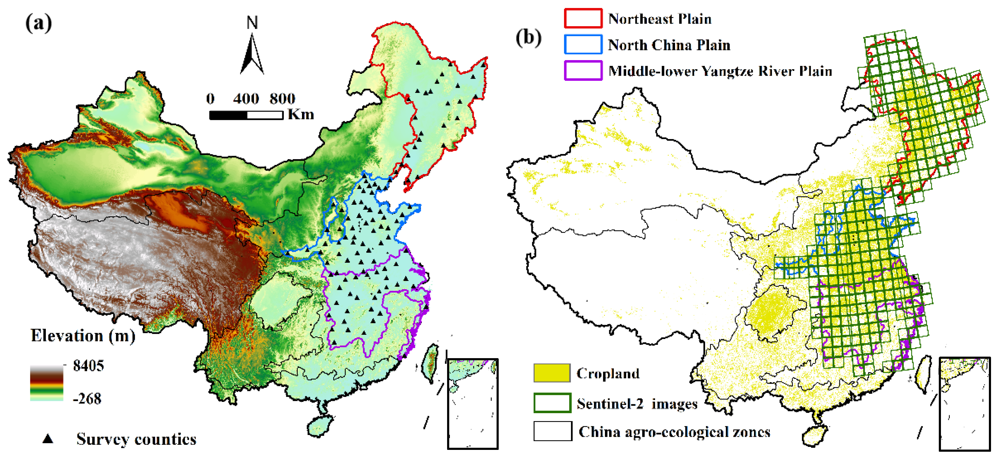
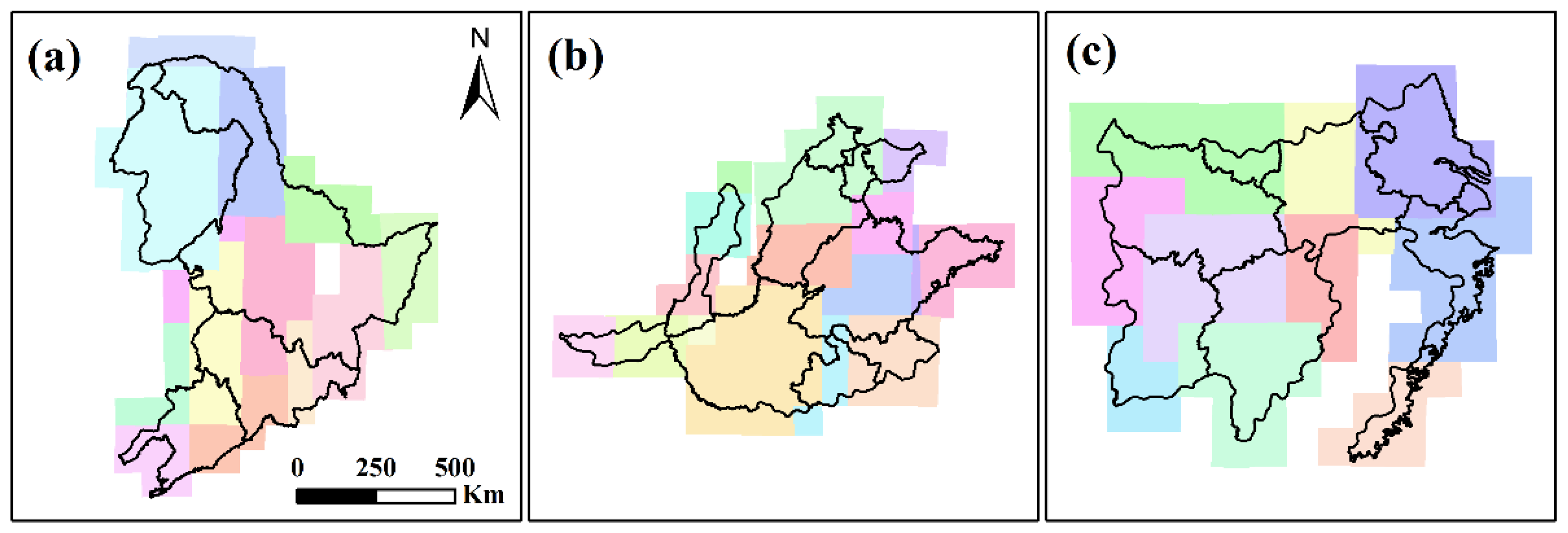
2.1. Study Area
2.2. Datasets
2.3. Methodology
2.3.1. Selecting Target Crop Species
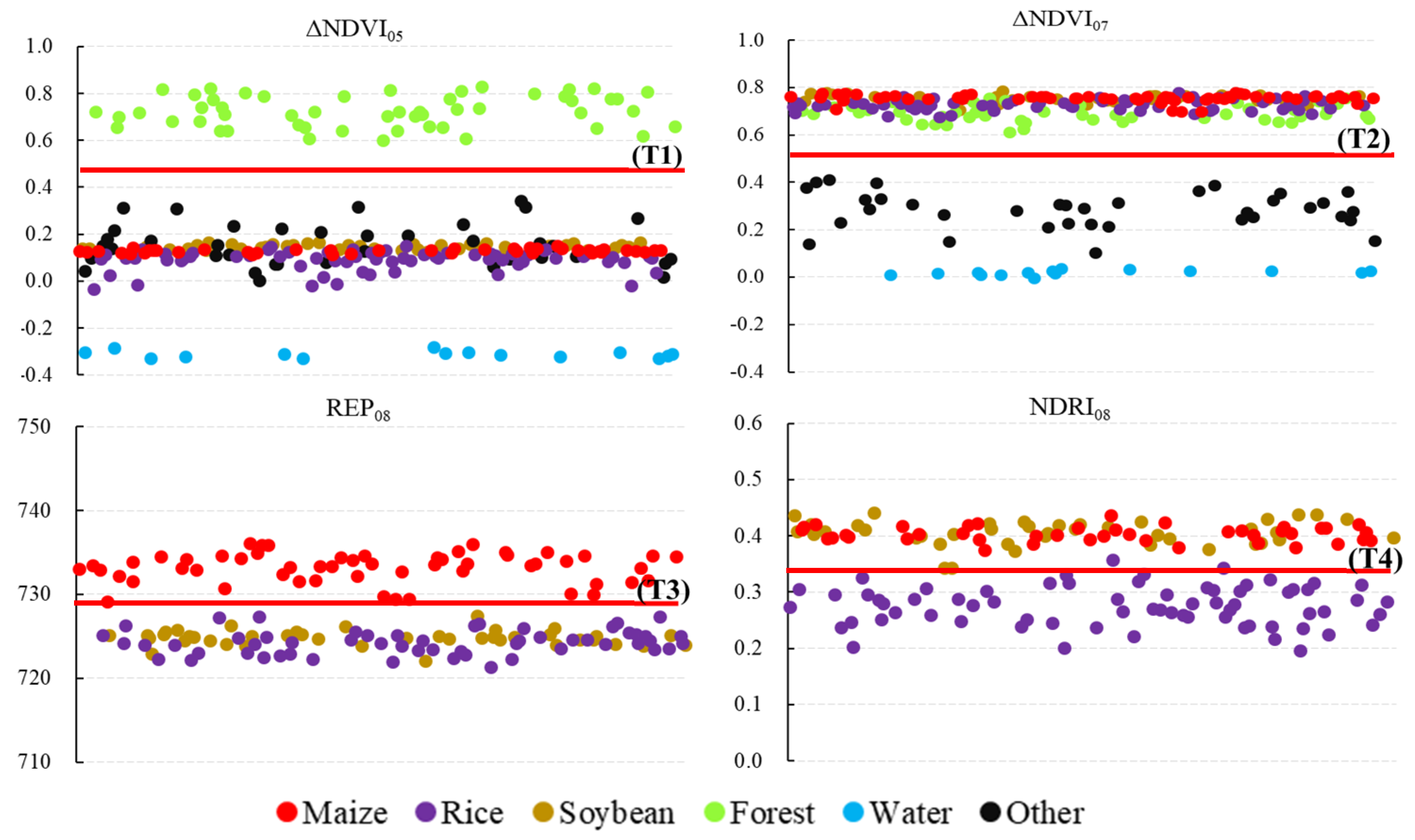
2.3.2. Designing Phenology-Based Indicators
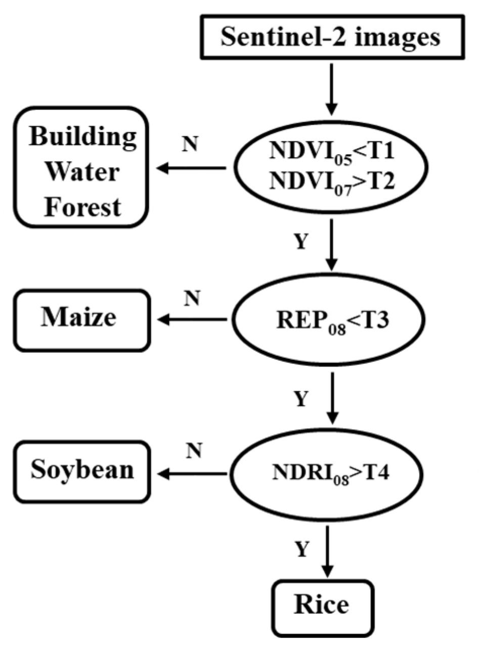
2.3.3. Mapping Crop Area
2.3.4. Accuracy Assessment
3. Results
3.1. Remote Sense-Based Crop Classification Models in the Typical Cropping Systems
3.1.1. Classification Model on the Northeast Plain
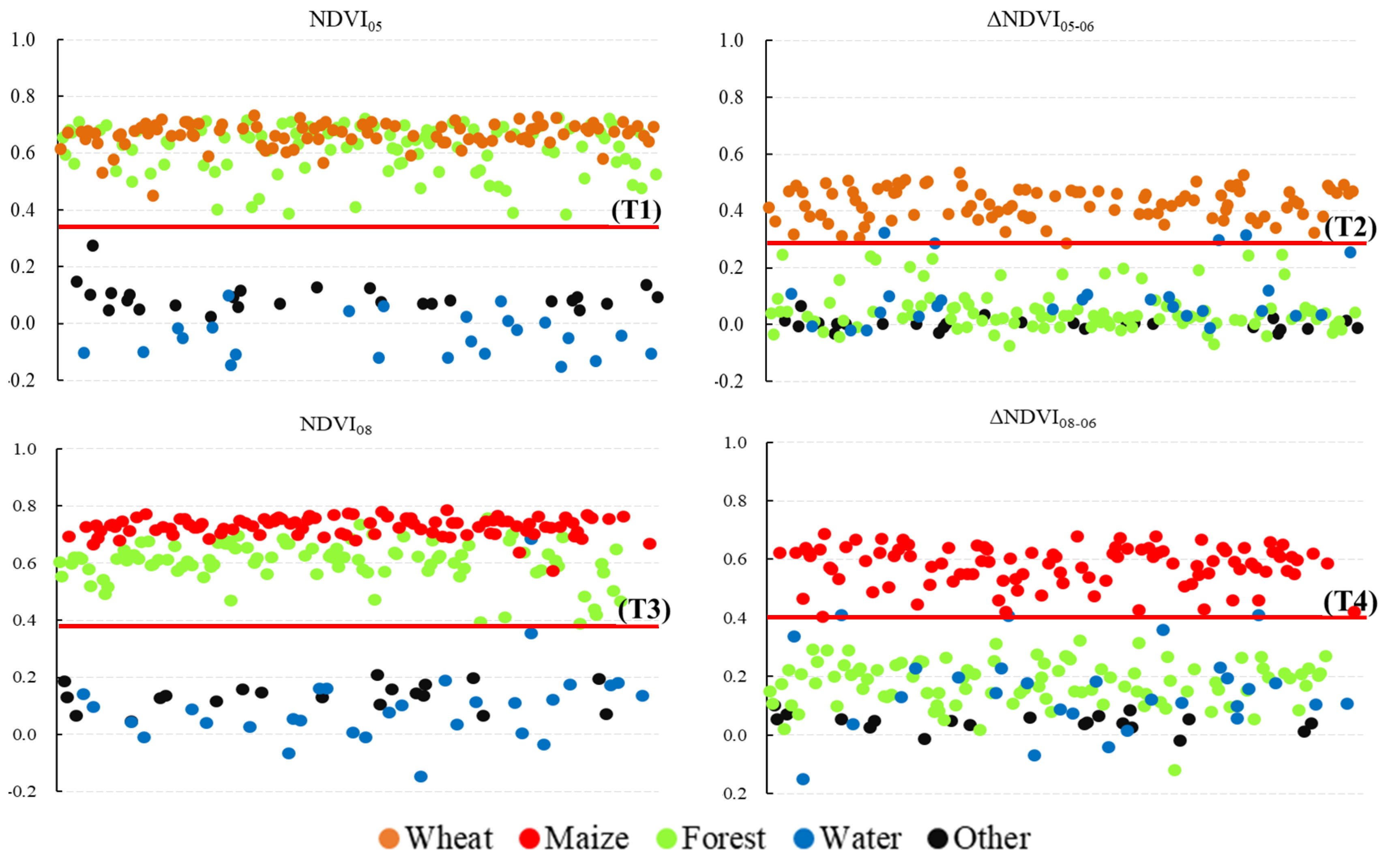
3.1.2. Classification Model for the North China Plain
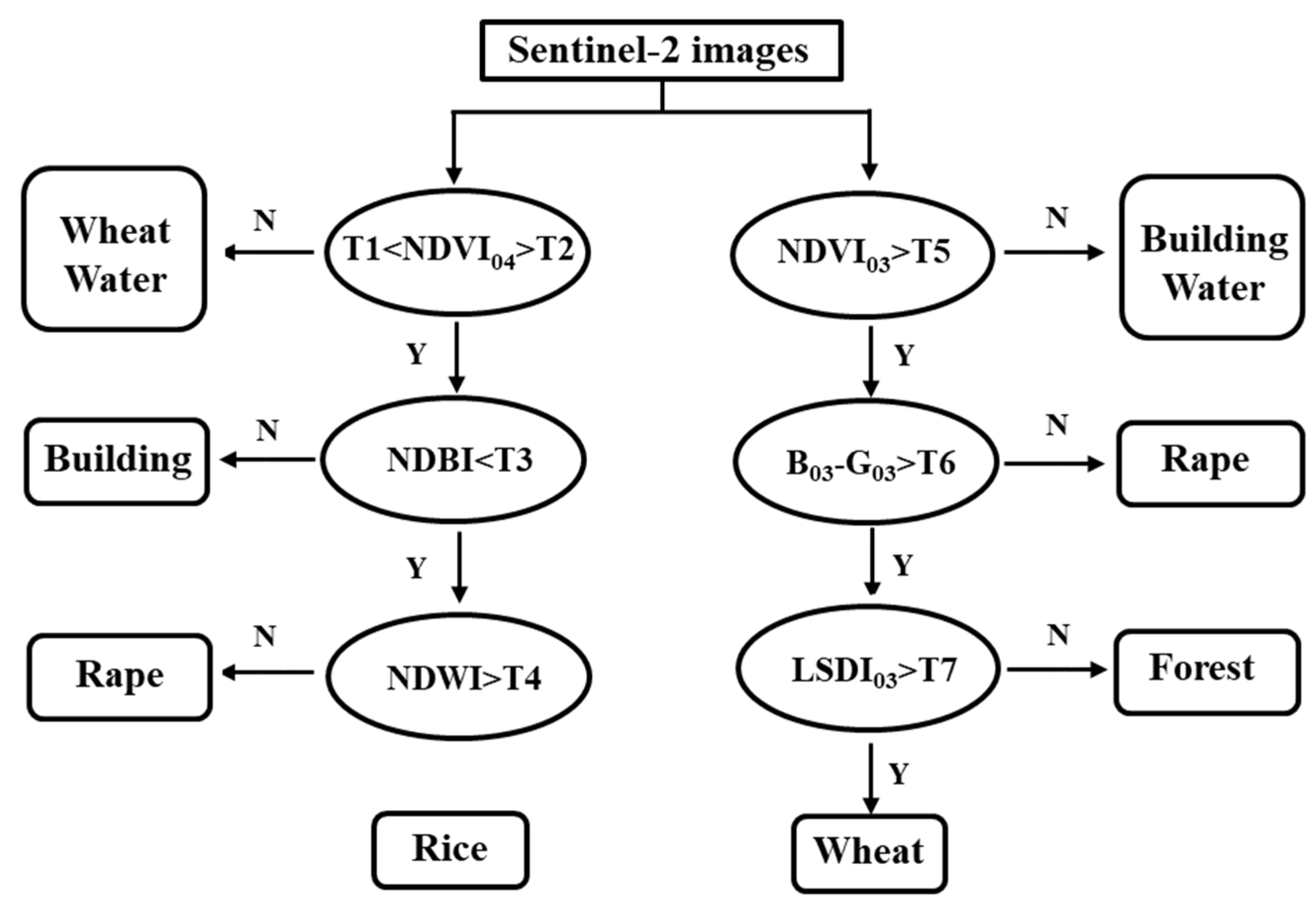
3.1.3. Classification Model for the Middle-Lower Yangtze River Plain
3.2. Spatial Distribution of the Major Crops in the Main Grain-Producing Regions
3.3. Spatial Agreement with the Google Maps Image Results
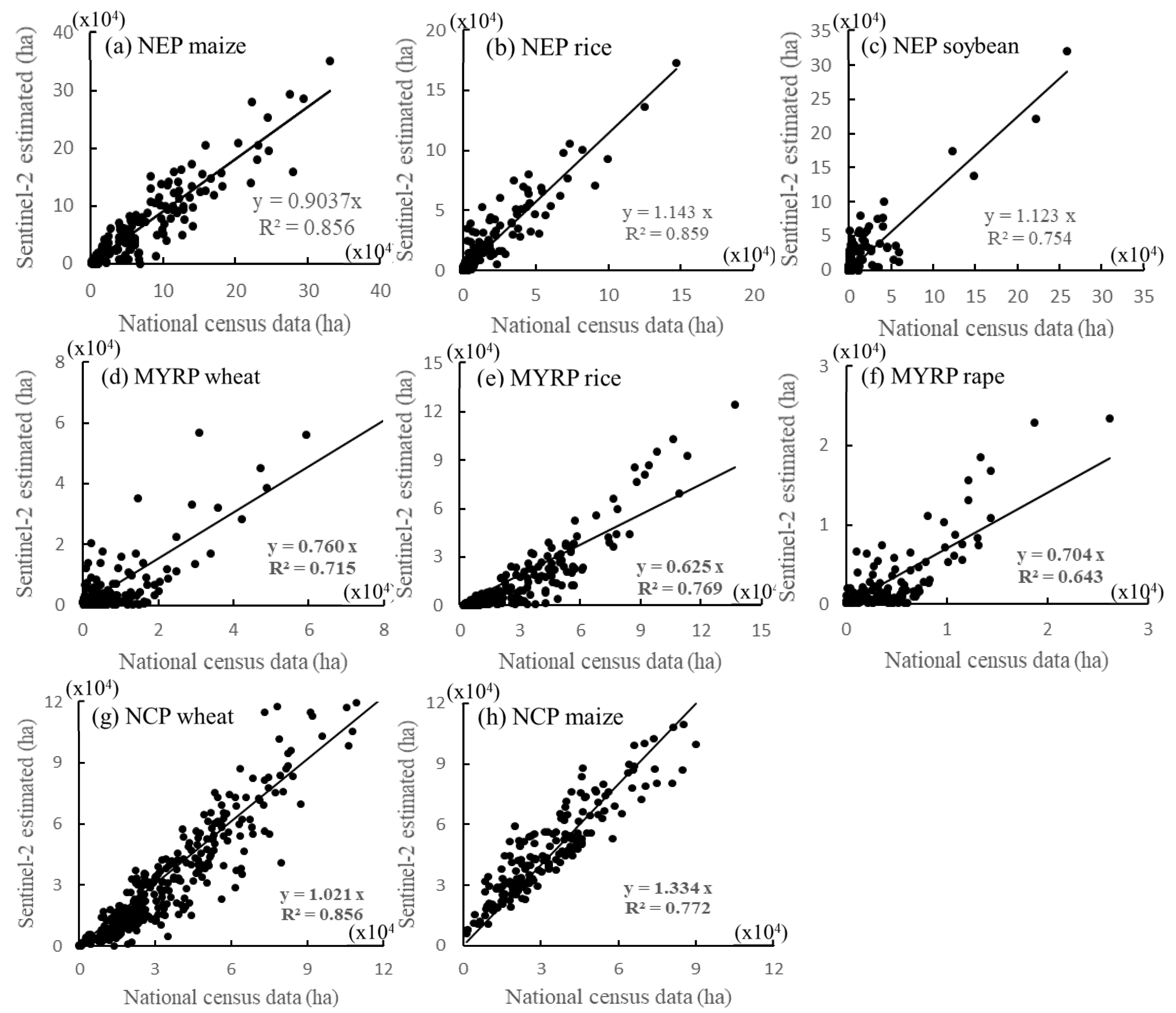
3.4. Evaluation with Agricultural Statistical Data
4. Discussion
5. Conclusions
Author Contributions
Funding
Acknowledgments
Conflicts of Interest
References
- He, G.; Zhao, Y.; Wang, L.; Jiang, S.; Zhu, Y. China’s food security challenge: Effects of food habit changes on requirements for arable land and water. J. Clean. Prod. 2019, 229, 739–750. [Google Scholar] [CrossRef]
- Wang, Q.; Liu, X.; Yue, T.; Wang, C.; Wilson, J.P. Using models and spatial analysis to analyze spatio-temporal variations of food provision and food potential across China’s agro-ecosystems. Ecol. Model. 2015, 306, 152–159. [Google Scholar] [CrossRef]
- Wang, Y.; Wu, P.; Engel, B.; Sun, S. Comparison of volumetric and stress-weighted water footprint of grain products in China. Ecol. Indic. 2015, 48, 324–333. [Google Scholar] [CrossRef]
- Kang, Y. Food safety governance in China: Change and continuity. Food Control. 2019, 106, 106752. [Google Scholar] [CrossRef]
- Yang, H.; Liu, J.; Savenije, H. China’s move to higher-meat diet hits water security. Nature 2008, 454, 397. [Google Scholar]
- Zang, Z.; Zou, X.; Xi, X.; Zhang, Y.; Zheng, D.; Sun, C. Quantitative characterization and comprehensive evaluation of regional water resources using the three red lines method. J. Geogr. Sci. 2016, 26, 397–414. [Google Scholar] [CrossRef] [Green Version]
- Feng, Z.; Yang, Y.; Zhang, Y.; Zhang, P.; Li, Y. Grain-for-green policy and its impacts on grain supply in West China. Land Use Policy 2005, 22, 301–312. [Google Scholar] [CrossRef]
- Liu, Z.; Yang, P.; Wu, W.; You, L. Spatiotemporal changes of cropping structure in China during 1980–2011. J. Geogr. Sci. 2018, 28, 1659–1671. [Google Scholar] [CrossRef] [Green Version]
- Xie, H.; Cheng, L.; Lu, H. Farmers’ responses to the winter wheat fallow policy in the groundwater funnel area of China. Land Use Policy 2018, 73, 195–204. [Google Scholar] [CrossRef]
- Xiao, X.; Boles, S.; Liu, J.; Zhuang, D.; Frolking, S.; Li, C.; Salas, W.; Moore, B. Mapping paddy rice agriculture in Southern China using multi-temporal MODIS images. Remote Sens. Environ. 2005, 95, 480–492. [Google Scholar] [CrossRef]
- Yin, Q.; Liu, M.; Cheng, J.; Ke, Y.; Chen, X. Mapping paddy rice planting area in Northeastern China using spatiotemporal data fusion and phenology-based method. Remote Sens. 2019, 11, 1699. [Google Scholar] [CrossRef] [Green Version]
- Qiu, B.; Huang, Y.; Chen, C.; Tang, Z.; Zou, F. Mapping spatiotemporal dynamics of maize in China from 2005 to 2017 through designing leaf moisture-based indicator from normalized multi-band drought index. Comput. Electron. Agric. 2018, 153, 82–93. [Google Scholar] [CrossRef]
- Jia, K.; Wu, B.; Li, Q. Crop classification using HJ satellite multispectral data in the North China plain. J. Appl. Remote Sens. 2013, 7, 73576. [Google Scholar] [CrossRef]
- Vintrou, E.; Desbrosse, A.; Bégué, A.; Traoré, S.; Baron, C.; Seen, D. Crop area mapping in West Africa using landscape stratification of MODIS time series and comparison with existing global land products. Int. J. Appl. Earth Obs. Geoinf. 2012, 14, 83–93. [Google Scholar] [CrossRef]
- Hu, Q.; Wu, W.; Song, Q.; Yu, Q.; Yang, P.; Tang, H. Recent progress in research of crop patterns mapping by using remote sensing. Sci. Agric. Sin. 2015, 48, 1900–1914. [Google Scholar]
- Tang, H.; Wenbin, W.; Yang, P. Recent progresses in monitoring crop spatial patterns by using remote sensing technologies. Sci. Agric. Sin. 2010, 43, 2879–2888. [Google Scholar]
- Mathur, A.; Foody, G. Crop classification by support vector machine with intelligently selected training data for an operational application. Int. J. Remote Sens. 2008, 29, 2227–2240. [Google Scholar] [CrossRef] [Green Version]
- Yang, C.; Everitt, J.; Murden, D. Evaluating high resolution SPOT 5 satellite imagery for crop identification. Comput. Electron. Agric. 2011, 75, 347–354. [Google Scholar] [CrossRef]
- Cai, Y.; Guan, K.; Peng, J.; Wang, S.; Seifert, C.; Wardlow, B.; Li, Z. A high-performance and in-season classification system of field-level crop types using time-series landsat data and a machine learning approach. Remote Sens. Environ. 2018, 210, 35–47. [Google Scholar] [CrossRef]
- Chang, J.; Hansen, M.C.; Pittman, K.; Carroll, M.; DiMiceli, C. Corn and soybean mapping in the United States using MODIS time-series data sets. Agron. J. 2007, 99, 1654. [Google Scholar] [CrossRef]
- Thenkabail, P.; Biradar, C.; Noojipady, P.; Dheeravath, V.; Li, Y.; Velpuri, M.; Gumma, M.; Gangalakunta, O.; Turral, H.; Cai, X.; et al. Global irrigated area map (GIAM), derived from remote sensing, for the end of the last millennium. Int. J. Remote Sens. 2009, 30, 3679–3733. [Google Scholar] [CrossRef]
- Biradar, C.; Thenkabail, P.; Noojipady, P.; Li, Y.; Dheeravath, V.; Turral, H.; Velpuri, M.; Gumma, M.; Gangalakunta, O.; Cai, X.; et al. A global map of rainfed cropland areas (GMRCA) at the end of last millennium using remote sensing. Int. J. Appl. Earth Obs. Geoinf. 2009, 11, 114–129. [Google Scholar] [CrossRef]
- Leff, B.; Ramankutty, N.; Foley, J.A. Geographic distribution of major crops across the world. Glob. Biogeochem. Cycles 2004, 18, GB1009. [Google Scholar] [CrossRef]
- Monfreda, C.; Ramankutty, N.; Foley, J.A. Farming the planet: 2. Geographic distribution of crop areas, yields, physiological types, and net primary production in the year 2000. Glob. Biogeochem. Cycles 2008, 22, GB1022. [Google Scholar] [CrossRef]
- Wu, B.; Li, Q. Crop planting and type proportion method for crop acreage estimation of complex agricultural landscapes. Int. J. Appl. Earth Obs. Geoinf. 2012, 16, 101–112. [Google Scholar] [CrossRef]
- Qiu, B.; Luo, Y.; Tang, Z.; Chen, C.; Lu, D.; Huang, H.; Chen, Y.; Chen, N.; Xu, W. Winter wheat mapping combining variations before and after estimated heading dates. ISPRS J. Photogramm. Remote Sens. 2017, 123, 35–46. [Google Scholar] [CrossRef]
- Wardlow, B.; Egbert, S. Large-area crop mapping using time-series MODIS 250 m NDVI data: An assessment for the U.S. Central Great Plains. Remote Sens. Environ. 2008, 112, 1096–1116. [Google Scholar] [CrossRef]
- Zhou, Q.; Yu, Q.; Liu, J.; Wu, W.; Tang, H. Perspective of Chinese GF-1 high-resolution satellite data in agricultural remote sensing monitoring. J. Integr. Agric. 2017, 16, 242–251. [Google Scholar] [CrossRef]
- Song, Q.; Zhou, Q.; Wu, W.; Hu, Q.; Lu, M.; Liu, S. Mapping regional cropping patterns by using GF-1 WFV sensor data. J. Integr. Agric. 2017, 16, 337–347. [Google Scholar] [CrossRef]
- Li, H.; Chen, Z.; Jiang, Z.; Wu, W.; Ren, J.; Liu, B.; Tuya, H. Comparative analysis of GF-1, HJ-1, and landsat-8 data for estimating the leaf area index of winter wheat. J. Integr. Agric. 2017, 16, 266–285. [Google Scholar] [CrossRef]
- Cabezas-Rabadán, C.; Pardo-Pascual, J.E.; Palomar-Vázquez, J.; Fernández-Sarría, A. Characterizing beach changes using high-frequency sentinel-2 derived shorelines on the valencian coast (Spanish mediterranean). Sci. Total Environ. 2019, 691, 216–231. [Google Scholar] [CrossRef] [PubMed]
- Griffiths, P.; Nendel, C.; Hostert, P. Intra-annual reflectance composites from sentinel-2 and landsat for National-scale crop and land cover mapping. Remote Sens. Environ. 2019, 220, 135–151. [Google Scholar] [CrossRef]
- Sánchez-Espinosa, A.; Schröder, C. Land use and land cover mapping in wetlands one step closer to the ground: Sentinel-2 versus landsat 8. J. Environ. Manag. 2019, 247, 484–498. [Google Scholar] [CrossRef] [PubMed]
- Immitzer, M.; Vuolo, F.; Atzberger, C. First experience with Sentinel-2 data for crop and tree species classification in Central Europe. Remote Sens. 2016, 8, 166. [Google Scholar] [CrossRef]
- Hegarty-Craver, M.; Polly, J.; O’Neil, M.; Ujeneza, N.; Rineer, J.; Beach, R.; Lapidus, D.; Temple, D. Remote crop mapping at scale: Using satellite imagery and UAV-acquired data as ground truth. Remote Sens. 2020, 12, 1984. [Google Scholar] [CrossRef]
- Zhu, J.; Pan, Z.; Wang, H.; Huang, P.; Sun, J.; Qin, F.; Liu, Z. An improved multi-temporal and multi-feature tea plantation identification method using Sentinel-2 imagery. Sensors 2019, 19, 2087. [Google Scholar] [CrossRef] [Green Version]
- Boryan, C.; Yang, Z.; Mueller, R.; Craig, M. Monitoring US agriculture: The US department of agriculture, National agricultural statistics service, cropland data layer program. Geocarto Int. 2011, 26, 341–358. [Google Scholar] [CrossRef]
- Liu, X.; Chen, F. Farming Systems in China; China Agriculture Press: Beijing, China, 2005. [Google Scholar]
- Wu, W.; Yang, P.; Tang, H.; Zhou, Q.; Chen, Z.; Shibasaki, R. Characterizing spatial patterns of phenology in cropland of China based on remotely sensed data. Agric. Sci. China 2010, 9, 101–112. [Google Scholar] [CrossRef]
- Firozjaei, K.; Alavipanah, K.; Liu, H.; Sedighi, A.; Mijani, N.; Kiavarz, M.; Weng, Q. A PCA–OLS model for assessing the impact of surface biophysical parameters on land surface temperature variations. Remote Sens. 2019, 11, 2094. [Google Scholar] [CrossRef] [Green Version]
- Chang, Q.; Xiao, X.; Jiao, W.; Wu, X.; Doughty, R.; Wang, J.; Du, L.; Zou, Z.; Qin, Y. Assessing consistency of spring phenology of snow-covered forests as estimated by vegetation indices, gross primary production, and solar-induced chlorophyll fluorescence. Agric. For. Meteorol. 2019, 275, 305–316. [Google Scholar] [CrossRef]
- Carbas, B.; Machado, N.; Oppolzer, D.; Ferreira, L.; Brites, C.; Rosa, E.; Barros, A. Comparison of near-infrared (NIR) and mid-infrared (MIR) spectroscopy for the determination of nutritional and antinutritional parameters in common beans. Food Chem. 2020, 306, 125509. [Google Scholar] [CrossRef] [PubMed]
- Zhang, M.; Su, W.; Fu, Y.; Zhu, D.; Xue, J.; Huang, J.; Wang, W.; Wu, J.; Yao, C. Super-resolution enhancement of sentinel-2 image for retrieving LAI and chlorophyll content of summer corn. Eur. J. Agron. 2019, 111, 125938. [Google Scholar] [CrossRef]
- Congalton, R. A review of assessing the accuracy of classifications of remotely sensed data. Remote Sens. Environ. 1991, 37, 270–279. [Google Scholar] [CrossRef]
- Qiu, B.; Lu, D.; Tang, Z.; Song, D.; Zeng, Y.; Wang, Z.; Chen, C.; Chen, N.; Huang, H.; Xu, W. Mapping cropping intensity trends in China during 1982–2013. Appl. Geogr. 2017, 79, 212–222. [Google Scholar] [CrossRef]
- Qiu, B.; Lu, D.; Tang, Z.; Chen, C.; Zou, F. Automatic and adaptive paddy rice mapping using landsat images: Case study in songnen plain in Northeast China. Sci. Total Environ. 2017, 598, 581–592. [Google Scholar] [CrossRef]
- Gray, J.; Friedl, M.; Frolking, S.; Ramankutty, N.; Nelson, A.; Gumma, M. Mapping Asian cropping intensity with MODIS. IEEE J. Sel. Top. Appl. Earth Obs. Remote Sens. 2014, 7, 3373–3379. [Google Scholar] [CrossRef]
- Tang, H.; Wu, W.; Yang, P.; Li, Z. Systematic synthesis of impacts of climate change on China’s crop production system. J. Integr. Agric. 2014, 13, 1413–1417. [Google Scholar] [CrossRef]
- Tao, J.; Wu, W.; Zhou, Y.; Wang, Y.; Jiang, Y. Mapping winter wheat using phenological feature of peak before winter on the North China plain based on time-series MODIS data. J. Integr. Agric. 2017, 16, 348–359. [Google Scholar] [CrossRef]
- Jiang, Y.; Wang, X.; Ti, J.; Yin, X.; Lei, Y.; Chu, Q.; Chen, F. Winter wheat water-saving potential in groundwater overexploitation district of North China plain. Agron. J. 2020, 112, 44–55. [Google Scholar] [CrossRef]


| % | Maize | Soybean | Paddy Rice | Wheat | Rape | Total |
|---|---|---|---|---|---|---|
| Northeast Plain | 64.95 | 14.43 | 18.73 | - | - | 98.11 |
| North China Plain | 40.63 | - | - | 49.63 | - | 90.26 |
| Middle-lower Yangtze River plain | - | 61.15 | 15.85 | 16.03 | 93.03 |
| Region | Crops | Indicators |
|---|---|---|
| Northeast Plain (NEP) | Maize, Soybean, Rice | NDVI, REP, NDRI |
| North China Plain (NCP) | Maize, Wheat | NDVI, ΔNDVI |
| Middle-lower Yangtze River plain (MYRP) | Wheat, Rice, Rape | NDVI, ΔNDVI, LDSI, NDBI, NDWI, B-G |
| Maize | Soybean | Rice | Others | User Accuracy | |
|---|---|---|---|---|---|
| Maize | 4557 | 103 | 24 | 180 | 0.94 |
| Soybean | 92 | 2800 | 69 | 148 | 0.90 |
| Rice | 73 | 37 | 1269 | 40 | 0.89 |
| Others | 159 | 116 | 14 | 4506 | 0.94 |
| Producer accuracy | 0.93 | 0.92 | 0.92 | 0.92 | |
| Overall accuracy | 0.93 | ||||
| Kappa | 0.90 |
| Winter Wheat | Summer Maize | Others | User Accuracy | |
|---|---|---|---|---|
| Winter wheat | 4635 | - | 125 | 0.97 |
| Summer maize | - | 5670 | 305 | 0.95 |
| Others | 356 | 464 | 18557 | 0.96 |
| Producer accuracy | 0.93 | 0.92 | 0.98 | |
| Overall accuracy | 0.96 | |||
| Kappa | 0.92 |
| Wheat | Rape | Rice | Others | User Accuracy | |
|---|---|---|---|---|---|
| Wheat | 2686 | 24 | - | 203 | 0.92 |
| Rape | 45 | 2961 | - | 81 | 0.96 |
| Rice | - | - | 3661 | 175 | 0.95 |
| Others | 193 | 150 | 294 | 5110 | 0.89 |
| Producer accuracy | 0.92 | 0.94 | 0.93 | 0.92 | |
| Overall accuracy | 0.93 | ||||
| Kappa | 0.90 |
© 2020 by the authors. Licensee MDPI, Basel, Switzerland. This article is an open access article distributed under the terms and conditions of the Creative Commons Attribution (CC BY) license (http://creativecommons.org/licenses/by/4.0/).
Share and Cite
Jiang, Y.; Lu, Z.; Li, S.; Lei, Y.; Chu, Q.; Yin, X.; Chen, F. Large-Scale and High-Resolution Crop Mapping in China Using Sentinel-2 Satellite Imagery. Agriculture 2020, 10, 433. https://doi.org/10.3390/agriculture10100433
Jiang Y, Lu Z, Li S, Lei Y, Chu Q, Yin X, Chen F. Large-Scale and High-Resolution Crop Mapping in China Using Sentinel-2 Satellite Imagery. Agriculture. 2020; 10(10):433. https://doi.org/10.3390/agriculture10100433
Chicago/Turabian StyleJiang, Yulin, Zhou Lu, Shuo Li, Yongdeng Lei, Qingquan Chu, Xiaogang Yin, and Fu Chen. 2020. "Large-Scale and High-Resolution Crop Mapping in China Using Sentinel-2 Satellite Imagery" Agriculture 10, no. 10: 433. https://doi.org/10.3390/agriculture10100433
APA StyleJiang, Y., Lu, Z., Li, S., Lei, Y., Chu, Q., Yin, X., & Chen, F. (2020). Large-Scale and High-Resolution Crop Mapping in China Using Sentinel-2 Satellite Imagery. Agriculture, 10(10), 433. https://doi.org/10.3390/agriculture10100433