
Do Advanced Spatial Strategies Depend on the Number of Flight Hours? The Case of Military Pilots

 ,
,  ,
,  and
and 
Abstract
:1. Introduction
2. Materials and Methods
2.1. Participants
2.2. Procedure
2.3. Measures
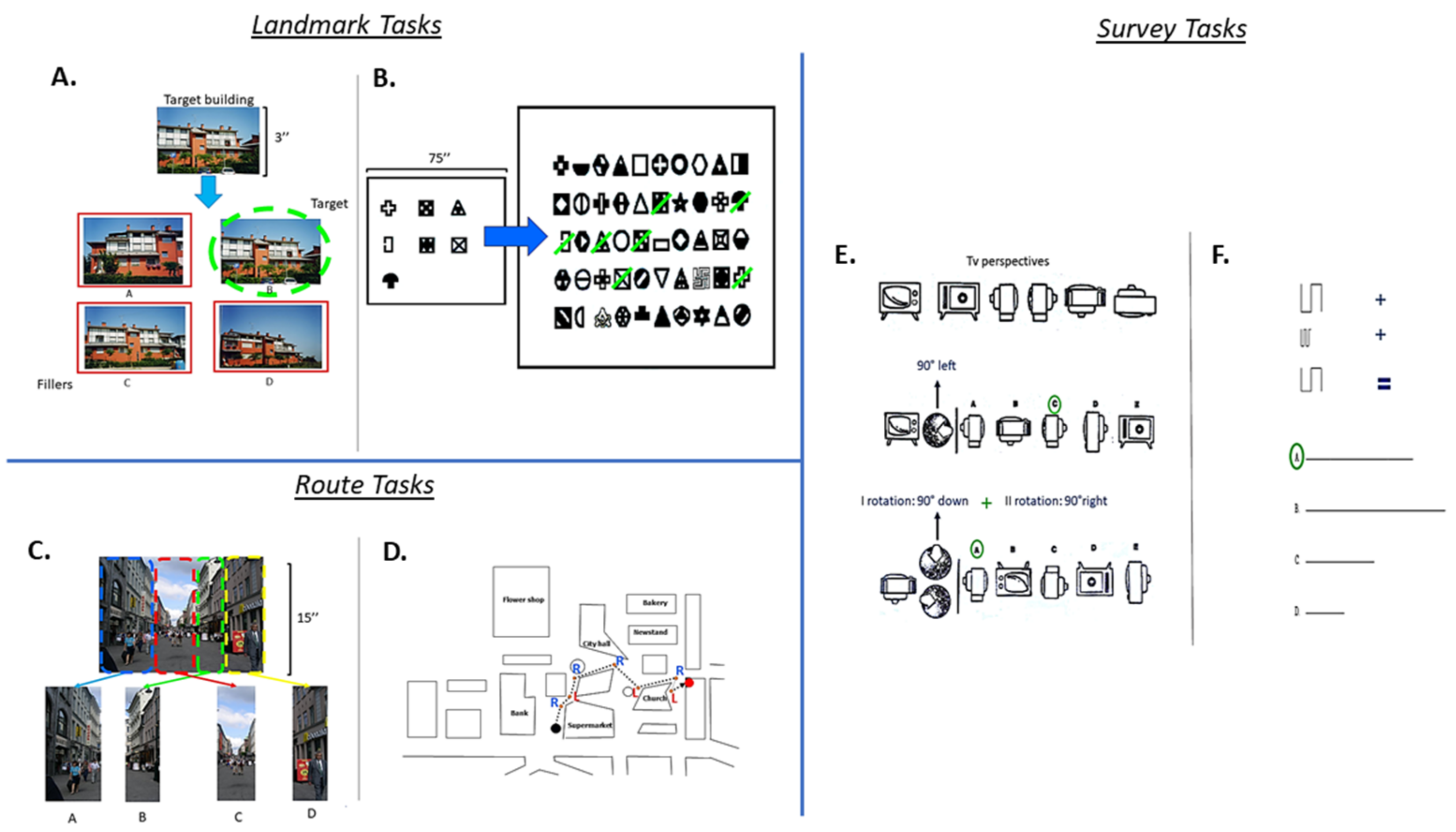
2.3.1. Landmark Tasks
2.3.2. Route Tasks
2.3.3. Survey Tasks
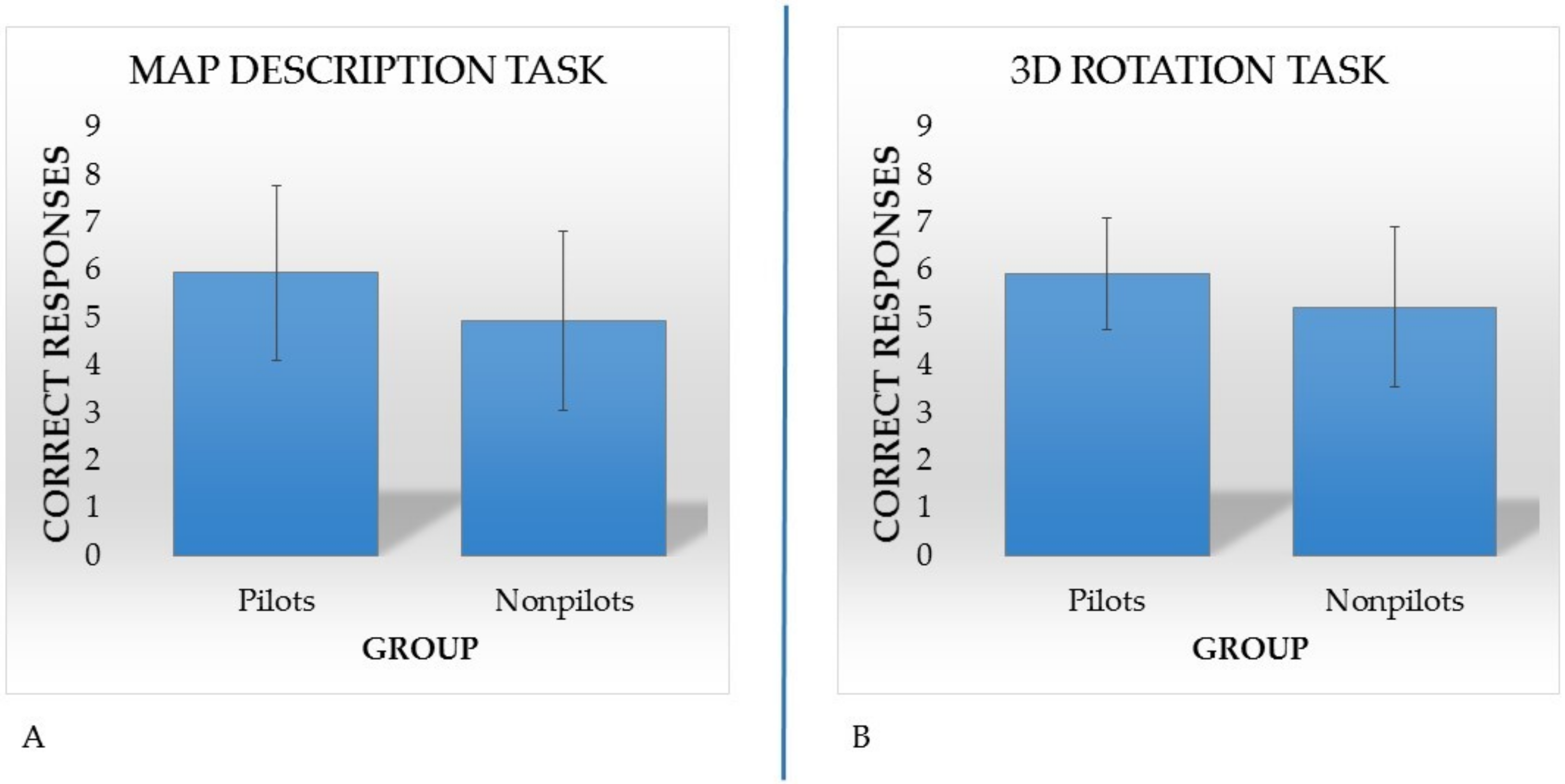
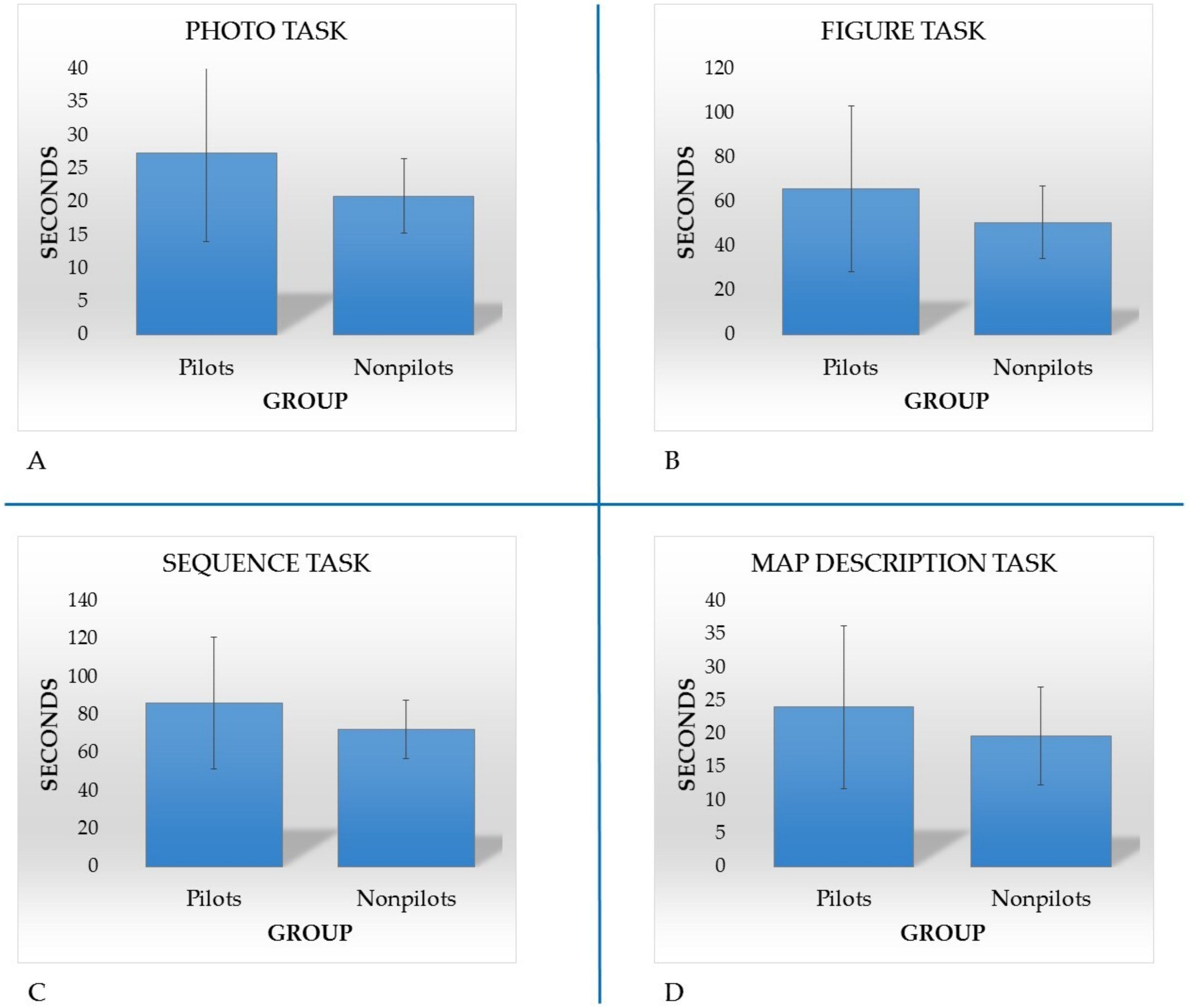
3. Results
4. Discussion
5. Conclusions
Author Contributions
Funding
Institutional Review Board Statement
Informed Consent Statement
Data Availability Statement
Conflicts of Interest
References
- Siegel, A.W.; White, S.H. The development of spatial representations of large-scale environments. Adv. Child Dev. Behav. 1975, 10, 9–55. [Google Scholar] [PubMed]
- Tversky, B. Cognitive maps, cognitive collages and spatial mental models. In Proceedings of the Spatial Information Theory: A Theoretical Basis for GIS, Lecture Notes in Computer Science, European Conference, Cosit’93, Marciana Marina, Italy, 19–22 September 1993; Frank, A.U., Campari, I., Eds.; Springer: Berlin/Heidelberg, Germnay, 1993; Volume 716, pp. 14–24. [Google Scholar]
- Montello, D.R. A New Framework for Understanding the Acquisition of Spatial Knowledge in Large-Scale Environments; Oxford University Press: New York, NY, USA, 1998; pp. 143–154. [Google Scholar]
- Nori, R.; Piccardi, L. Familiarity and spatial cognitive style: How important are they for spatial representation? In Spatial Memory: Visuospatial Processes, Cognitive Performance and Developmental Effects; Thomas, J.B., Ed.; Nova Science: New York, NY, USA, 2011; pp. 103–124. [Google Scholar]
- Lawton, C.A. Strategies for indoor wayfinding: The role of orientation. J. Environ. Psycjol. 1996, 16, 137–145. [Google Scholar] [CrossRef]
- Dogu, U.; Erkip, F. Spatial factors affecting wayfinding and orientation: A case study in a shopping mall. Environ. Behav. 2000, 32, 731–755. [Google Scholar]
- Bocchi, A.; Giancola, M.; Piccardi, L.; Palmiero, M.; Nori, R.; D’Amico, S. How would you describe a familiar route or put in order the landmarks along it? It depends on your cognitive style! Exp. Brain Res. 2018, 236, 3121–3129. [Google Scholar] [CrossRef] [PubMed]
- Boccia, M.; Piccardi, L.; Di Marco, M.; Pizzamiglio, L.; Guariglia, C. Does field independence predict visuo-spatial abilities underpinning human navigation? Behavioural evidence. Exp. Brain Res. 2016, 234, 2799–2807. [Google Scholar] [CrossRef]
- Boccia, M.; Piccardi, L.; D’Alessandro, A.; Nori, R.; Guariglia, C. Restructuring the navigational field: Individual predisposition towards field independence predicts preferred navigational strategy. Exp. Brain Res. 2017, 235, 1741–1748. [Google Scholar] [CrossRef]
- Boccia, M.; Vecchione, F.; Piccardi, L.; Guariglia, C. Effect of Cognitive Style on Learning and Retrieval of Navigational Environments. Front. Pharmacol. 2017, 8, 496. [Google Scholar] [CrossRef]
- Boccia, M.; Vecchione, F.; Di Vita, A.; D’Amico, S.; Guariglia, C.; Piccardi, L. Effect of Cognitive Style on Topographical Learning Across Life Span: Insights From Normal Development. Child Dev. 2019, 90, 462–470. [Google Scholar] [CrossRef]
- Nazareth, A.; Huang, X.; Voyer, D.; Newcombe, N. A meta-analysis of sex differences in human navigation skills. Psychon. Bull. Rev 2019, 5, 1503–1528. [Google Scholar]
- Lawton, C.A. Gender and regional differences in spatial referents used in direction giving. Sex Roles 2001, 44, 321–337. [Google Scholar] [CrossRef]
- Lawton, C.A. Gender, spatial abilities and wayfinding. In Handbook of Gender Research in Psychology; Chrisler, J., McCreary, D., Eds.; Springer: New York, NY, USA, 2010; pp. 317–341. [Google Scholar]
- Piccardi, L.; Risetti, M.; Nori, R.; Tanzilli, A.; Bernardi, L.; Guariglia, C. Perspective changing in primary and secondary learning: A gender difference study. Learn. Individ. Diff. 2011, 21, 114–118. [Google Scholar] [CrossRef]
- Piccardi, L.; Bianchini, F.; Iasevoli, L.; Giannone, G.; Guariglia, C. Sex differences in a landmark environmental re-orientation task only during the learning phase. Neurosc. Lett. 2011, 503, 181–185. [Google Scholar] [CrossRef] [PubMed]
- Bianchini, F.; Verde, P.; Colangeli, S.; Boccia, M.; Strollo, F.; Guariglia, C.; Bizzarro, G.; Piccardi, L. Effects of oral contraceptives and natural menstrual cycling on environmental learning. BMC Womens Health 2018, 18, 179. [Google Scholar] [CrossRef] [PubMed]
- Palmiero, M.; Nori, R.; Rogolino, C.; D’Amico, S.; Piccardi, L. Sex differences in visuospatial and navigational working memory: The role of mood induced by background music. Exp. Brain Res. 2016, 234, 2381–2389. [Google Scholar] [CrossRef]
- Nori, R.; Piccardi, L.; Migliori, M.; Guidazzoli, A.; Frasca, F.; De Luca, D.; Giusberti, F. Sex differences in learning real and virtual environments. Comput. Hum. Behav. 2015, 48, 72–77. [Google Scholar] [CrossRef]
- Moffat, S.D.; Zonderman, A.B.; Resnick, S.M. Age differences in spatial memory in a virtual environment navigation task. Neurobiol. Aging 2001, 22, 787–796. [Google Scholar] [CrossRef]
- Ramanoël, S.; York, E.; Le Petit, M.; Lagrené, K.; Habas, C.; Arleo, A. Age-Related Differences in Functional and Structural Connectivity in the Spatial Navigation Brain Network. Front. Neural Circuits 2019, 13, 69. [Google Scholar] [CrossRef]
- Li, A.W.Y.; King, J. Spatial memory and navigation in ageing: A systematic review of MRI and fMRI studies in healthy participants. Neurosci. Biobehav. Rev. 2019, 103, 33–49. [Google Scholar]
- Muffato, V.; Hilton, C.; Meneghetti, C.; De Beni, R.; Wiener, J.M. Evidence for age-related deficits in object-location binding during place recognition. Hippocampus 2019, 29, 971–979. [Google Scholar] [CrossRef]
- Fernandez-Baizan, C.; Diaz-Caceres, E.; Arias, J.L.; Mendez, M. Egocentric and allocentric spatial memory in healthy aging: Performance on real-world tasks. Braz. J. Med. Biol. Res. 2019, 52, e8041. [Google Scholar] [CrossRef]
- Piccardi, L.; Nori, R.; Palermo, L.; Guariglia, C. Age effect in generating mental images of building but not common objects. Neurosc. Lett. 2015, 602, 79–83. [Google Scholar] [CrossRef]
- Guzmán, J.F.; Pablos, A.M.; Pablos, C. Perceptual-cognitive skills and performance in orienteering. Percept. Mot. Skills 2008, 107, 159–164. [Google Scholar] [CrossRef]
- Piccardi, L.; Palmiero, M.; Bocchi, A.; Boccia, M.; Guariglia, C. How does environmental knowledge allow us to come back home? Exp. Brain Res. 2019, 237, 1811–1820. [Google Scholar] [CrossRef]
- Verde, P.; Piccardi, L.; Bianchini, F.; Guariglia, C.; Carrozzo, P.; Morgagni, F.; Tomao, E. Gender has no effect on pilots’ navigational memory. AMHP 2015, 86, 103–111. [Google Scholar] [CrossRef] [PubMed]
- Verde, P.; Angelino, G.; Piccolo, F.; Carrozzo, P.; Bottiglieri, A.; Lugli, L.; Piccardi, L.; Nori, R. Spatial orientation and directional judgments in pilots vs. nonpilots. AMHP 2018, 89, 857–862. [Google Scholar] [CrossRef] [PubMed]
- Verde, P.; Angelino, G.; Piccolo, F.; Carrozzo, P.; Piccardi, L.; Nori, R. Engineers’ abilities influence spatial perspective changing. IJEE 2019, 1, 106–113. [Google Scholar] [CrossRef]
- Weisberg, S.M.; Newcombe, N.S.; Chatterjee, A. Everyday taxi drivers: Do better navigators have larger hippocampi? Cortex 2019, 115, 280–293. [Google Scholar] [CrossRef]
- Lopez, A.; Caffò, A.O.; Bosco, A. Topographical disorientation in aging. Familiarity with the environment does matter. Neurol. Sci. 2018, 39, 1519–1528. [Google Scholar] [CrossRef] [PubMed]
- Nori, R.; Piccardi, L.; Maialetti, A.; Goro, M.; Rossetti, A.; Argento, O.; Guariglia, C. No Gender Differences in Egocentric and Allocentric Environmental Transformation after Compensating for Male Advantage by Manipulating Familiarity. Front. Neurosci. 2018, 12, 204. [Google Scholar] [CrossRef] [Green Version]
- Pazzaglia, F.; Cornoldi, C.; De Beni, R. Differenze individuali nella rappresentazione dello spazio e nell’abilità di orientamento: Presentazione di un questionario autovalutativo. GIP 2000, 27, 627–650. [Google Scholar]
- Pazzaglia, F.; De Beni, R. Strategies of processing spatial information in survey and landmark centered individuals. Eur. J. Cogn. Psychol. 2001, 13, 493–508. [Google Scholar] [CrossRef]
- Shelton, A.L.; Gabrieli, J.D.E. Neural correlates of encoding space from route and survey perspectives. J. Neurosci. 2002, 22, 2711–2717. [Google Scholar] [CrossRef] [PubMed]
- Shelton, A.L.; Marchette, S.A.; Furman, A.J. A mechanistic approach to individual differences in spatial learning. Psychol. Learn. Motiv. 2013, 59, 223–258. [Google Scholar]
- Bocchi, A.; Palmiero, M.; Boccia, M.; Di Vita, A.; Guariglia, C.; Piccardi, L. Travel planning ability in right brain-damaged patients: Two case reports. Front. Hum. Neurosci. 2020, 14, 117. [Google Scholar] [CrossRef] [PubMed]
- Bocchi, A.; Palmiero, M.; Piccardi, L. Travel planning in men and women. Who is better? Curr. Psychol. 2021. [Google Scholar] [CrossRef]
- Nori, R.; Piccardi, L. I believe to be good in orienteering…but is that true? Cogn. Process. 2015, 16, 301–307. [Google Scholar] [CrossRef]
- Boccia, M.; Rosella, M.; Vecchione, F.; Tanzilli, A.; Palermo, L.; D’Amico, S.; Guariglia, C.; Piccardi, L. Enhancing Allocentric spatial recall in pre-schoolers through navigational training programme. Front. Neurosci. 2017, 11, 574. [Google Scholar] [CrossRef] [PubMed]
- Frick, A. Spatial transformation abilities and their relation to later mathematics performance. Psychol. Res. 2019, 83, 1465–1484. [Google Scholar] [CrossRef] [PubMed] [Green Version]
- Forloines, M.R.; Reid, M.A.; Thompkins, A.M.; Robinson, J.L.; Katz, J.S. Neurofunctional correlates of geometry and feature use in a virtual environment. J. Exp. Psychol. Learn Mem. Cogn. 2019, 45, 1347–1363. [Google Scholar] [CrossRef]
- Nori, R.; Palmiero, M.; Bocchi, A.; Giannini, A.M.; Piccardi, L. The specific role of spatial orientation skills in predicting driving behaviour. Transport. Res. Part F 2020, 71, 259–271. [Google Scholar] [CrossRef]
- Bocchi, A.; Palmiero, M.; Nori, R.; Verde, P.; Piccardi, L. Does spatial cognitive style affect how navigational strategy is planned? Exp. Brain Res. 2019, 237, 2523–2533. [Google Scholar] [CrossRef]
- Boccia, M.; Guariglia, P.; Piccardi, L.; De Martino, G.; Giannini, A.M. The detail is more pleasant than the whole: Global and local prime affect esthetic appreciation of artworks showing whole-part ambiguity. Att. Percept. Psychophys. 2020, 82, 3266–3272. [Google Scholar] [CrossRef] [PubMed]
- Kozhevnikov, M.; Kosslyn, S.M.; Shepard, J. Spatial versus object visualizers: A new characterization of visual cognitive style. Mem. Cogn. 2005, 33, 710–726. [Google Scholar] [CrossRef] [PubMed] [Green Version]
- Kozhevnikov, M. Cognitive styles in the context of modern psychology: Toward an integrated framework of cognitive style. Psychol. Bull. 2007, 133, 464–481. [Google Scholar] [CrossRef] [PubMed]
- Uttal, D.H.; Meadow, N.G.; Tipton, E.; Hand, L.L.; Alden, A.R.; Warren, C.; Newcombe, N.S. The malleability of spatial skills: A meta-analysis of training studies. Psychol. Bull. 2013, 139, 352–402. [Google Scholar] [CrossRef]
- Kozlowski, L.T.; Bryant, K.J. Sense of direction, spatial orientation, and cognitive maps. J. Exp. Psychol. Hum. Percept. Perform. 1977, 3, 590–598. [Google Scholar] [CrossRef]
- Sholl, M.J.; Kenny, R.; Della Porta, K.A. Allocentric-heading recall and its relation to self-reported sense of direction. J. Exp. Psychol. Learn. Mem. Cogn. 2006, 32, 516–533. [Google Scholar] [CrossRef] [PubMed]
- Piccardi, L.; De Luca, M.; Nori, R.; Palermo, L.; Iachini, F.; Guariglia, C. Navigational Style Influences Eye Movement Pattern during Exploration and Learning of an Environmental Map. Front. Behav. Neurosci. 2016, 10, 140. [Google Scholar] [CrossRef] [Green Version]
- Verde, P.; Piccardi, L.; Bianchini, F.; Trivelloni, P.; Guariglia, C.; Tomao, E. No gender differences in performing a mental rotation task among pilots. Aviat. Space Enviro. Med. 2013, 84, 726–729. [Google Scholar] [CrossRef]
- Sutton, J.E.; Buset, M.; Keller, M. Navigation Experience and Mental Representations of the Environment: Do Pilots Build Better Cognitive Maps? PLoS ONE 2014, 9, e90058. [Google Scholar] [CrossRef]
- Glicksohn, J.; Naor-Ziv, R. Personalityprofiling of pilots: Traits and cognitive style. Int. J. Personal. Psychol. 2016, 2, 7–14. [Google Scholar]
- Nori, R.; Giusberti, F. Predicting cognitive styles from spatial abilities. Am. J. Psychol. 2006, 119, 67–86. [Google Scholar] [CrossRef]
- Nori, R.; Giusberti, F. Cognitive styles: Errors in the directional judgments. Perception 2003, 32, 307–320. [Google Scholar] [CrossRef] [PubMed]
- Maguire, E.A.; Gadian, D.G.; Johnsrude, I.S.; Good, C.D.; Ashburner, J.; Frackowiak, R.; Frith, C.D. Navigation-related structural change in the hippocampi of taxi drivers. Proc. Natl. Acad. Sci. USA 2000, 97, 4398–4403. [Google Scholar] [CrossRef] [Green Version]
- Maguire, E.A.; Woollett, K.; Spiers, H.J. London taxi drivers and bus drivers: A structural MRI and neuropsychologicalanalysis. Hippocampus 2006, 16, 1091–1101. [Google Scholar] [CrossRef] [PubMed]
- Iaria, G.; Bogod, N.; Fox, C.J.; Barton, J.J. Developmental topographic disorientation: Case one. Neuropsychologia 2009, 47, 30–40. [Google Scholar] [CrossRef]
- Bianchini, F.; Incoccia, C.; Palermo, L.; Piccardi, L.; Zompanti, L.; Sabatini, U.; Peran, P.; Guariglia, C.; Bianchini, F.; Incoccia, C.; et al. Developmental topographical disorientation in a healthy subject. Neuropsychologia 2010, 48, 1563–1573. [Google Scholar] [CrossRef]
- Casner, S.M. The effect of GPS and moving map displays on navigational awareness while flying under VFR. Int. J. Appl. Aviat. Stud. 2005, 5, 153–165. [Google Scholar]
- Aretz, A.J. The Design of Electronic Map Displays. Hum. Factors 1991, 33, 85–101. [Google Scholar] [CrossRef]
- Lopez, A.; Caffò, A.O.; Bosco, A. The impact of age and familiarity with the environment on categorical and coordinate spatial relation representations. Scand. J. Psychol. 2021, 62, 125–133. [Google Scholar] [CrossRef]
- Piccardi, L.; Palmiero, M.; Bocchi, A.; Giannini, A.M.; Boccia, M.; Baralla, F.; Cordellieri, P.; D’Amico, S. Continuous Environmental Changes May Enhance Topographic Memory Skills. Evidence from L’Aquila Earthquake-Exposed Survivors. Front. Hum. Neurosci. 2019, 12, 318. [Google Scholar] [CrossRef] [Green Version]
- Sweller, J. Cognitive load during problem solving: Effects on learning. Cogn. Sci. 1988, 12, 257–285. [Google Scholar] [CrossRef]
- Sweller, J. Cognitive load theory: Recent theoretical advances. In Cognitive Load Theory; Plass, J.L., Moreno, R., Brünken, R., Eds.; Cambridge University Press: Cambridge, UK, 2010; pp. 29–47. [Google Scholar]
- Sweller, J. Cognitive load theory, learning difficulty, and instructional design. Learn. Instr. 1994, 4, 295–312. [Google Scholar] [CrossRef]
- Sweller, J.; Chandler, P. Why Some Material Is Difficult to Learn. Cogn. Instr. 1994, 12, 185–233. [Google Scholar] [CrossRef]
- Techentin, C.; Voyer, D.; Voyer, S.D. Spatial abilities and aging: A meta-analysis. Exp. Aging Res. 2014, 40, 395–425. [Google Scholar] [CrossRef] [PubMed]
- Horton, S.; Baker, J.; Schorer, J. Expertise and aging: Maintaining skills through the lifespan. Eur. Rev. Aging Phys. Act. 2008, 5, 89–96. [Google Scholar] [CrossRef] [Green Version]
- Cimadevilla, J.M.; Piccardi, L. Spatial skills. Handb. Clin. Neurol. 2020, 175, 65–79. [Google Scholar]


| Pilot Groups | Nonpilot Groups | |||
|---|---|---|---|---|
| Cognitive Style | Frequencies | Percentages | Frequencies | Percentages |
| Landmark | 7 | 6.61% | 10 | 10.87% |
| Route | 33 | 31.13% | 42 | 45.65% |
| Survey | 66 | 62.26% | 40 | 43.48% |
| Min | Max | M | SD | 1 | 2 | 3 | 4 | 5 | 6 | 7 | |
|---|---|---|---|---|---|---|---|---|---|---|---|
| SCST-Photo Task (1) | 5.00 | 7.00 | 6.80 | 0.42 | 1 | 0.05 | 0.08 | 0.06 | 0.03 | 0.01 | 0.09 |
| SCST-Figure Task (2) | 4.00 | 7.00 | 6.56 | 0.68 | 0.05 | 1 | 0.08 | −0.03 | 0.07 | 0.08 | −0.07 |
| SCST-Sequence Task (3) | 2.00 | 7.00 | 6.19 | 1.08 | 0.08 | 0.08 | 1 | 0.04 | 0.36 | 0.10 | 0.02 |
| SCST-Map Description Task (4) | 2.00 | 7.00 | 5.96 | 1.83 | 0.06 | −0.03 | 0.04 | 1 | 0.17 | 0.03 | −0.09 |
| SCST-3D Rotation Task (5) | 2.00 | 7.00 | 5.93 | 1.17 | 0.03 | 0.07 | 0.36 | 0.17 | 1 | 0.006 | 0.01 |
| SCST-Sum and Straighten Task (6) | 0.00 | 6.00 | 3.12 | 1.20 | 0.1 | 0.08 | 0.10 | 0.03 | 0.00 | 1 | −0.06 |
| Flight Hours (7) | 15.00 | 6000.00 | 724.11 | 1205.02 | 0.09 | −0.07 | 0.02 | −0.09 | 0.01 | −0.064 | 1 |
| Min | Max | M | SD | 1 | 2 | 3 | 4 | 5 | 6 | 7 | |
|---|---|---|---|---|---|---|---|---|---|---|---|
| SCST-Photo Task (1) | 10.01 | 86.03 | 27.40 | 13.36 | 1 | 0.28 | 0.45 | 0.19 | 0.14 | 0.14 | −0.02 |
| SCST-Figure Task (2) | 18.00 | 260.00 | 65.95 | 37.35 | 0.28 | 1 | 0.180 | 0.13 | 0.18 | 0.10 | −0.07 |
| SCST-Sequence Task (3) | 34.00 | 284.57 | 86.24 | 34.59 | 0.45 | 0.18 | 1 | 0.38 | 0.37 | 0.36 | 0.04 |
| SCST-Map Description Task (4) | 5.66 | 64.00 | 24.01 | 12.30 | 0.19 | 0.13 | 0.38 | 1 | 0.32 | 0.15 | 0.24 |
| SCST-3D Rotation Task (5) | 23.00 | 200.94 | 76.60 | 35.40 | 0.14 | 0.18 | 0.37 | 0.32 | 1 | 0.34 | −0.15 |
| SCST-Sum and Straighten Task (6) | 27.51 | 411.56 | 95.52 | 56.41 | 0.14 | 0.10 | 0.36 | 0.15 | 0.34 | 1 | −0.11 |
| Flight Hours (7) | 15.00 | 6000.00 | 724.11 | 1205.02 | −0.02 | −0.07 | 0.04 | 0.24 | −0.15 | −0.11 | 1 |
Publisher’s Note: MDPI stays neutral with regard to jurisdictional claims in published maps and institutional affiliations. |
© 2021 by the authors. Licensee MDPI, Basel, Switzerland. This article is an open access article distributed under the terms and conditions of the Creative Commons Attribution (CC BY) license (https://creativecommons.org/licenses/by/4.0/).
Share and Cite
Giancola, M.; Verde, P.; Cacciapuoti, L.; Angelino, G.; Piccardi, L.; Bocchi, A.; Palmiero, M.; Nori, R. Do Advanced Spatial Strategies Depend on the Number of Flight Hours? The Case of Military Pilots. Brain Sci. 2021, 11, 851. https://doi.org/10.3390/brainsci11070851
Giancola M, Verde P, Cacciapuoti L, Angelino G, Piccardi L, Bocchi A, Palmiero M, Nori R. Do Advanced Spatial Strategies Depend on the Number of Flight Hours? The Case of Military Pilots. Brain Sciences. 2021; 11(7):851. https://doi.org/10.3390/brainsci11070851
Chicago/Turabian StyleGiancola, Marco, Paola Verde, Luigi Cacciapuoti, Gregorio Angelino, Laura Piccardi, Alessia Bocchi, Massimiliano Palmiero, and Raffaella Nori. 2021. "Do Advanced Spatial Strategies Depend on the Number of Flight Hours? The Case of Military Pilots" Brain Sciences 11, no. 7: 851. https://doi.org/10.3390/brainsci11070851
APA StyleGiancola, M., Verde, P., Cacciapuoti, L., Angelino, G., Piccardi, L., Bocchi, A., Palmiero, M., & Nori, R. (2021). Do Advanced Spatial Strategies Depend on the Number of Flight Hours? The Case of Military Pilots. Brain Sciences, 11(7), 851. https://doi.org/10.3390/brainsci11070851