Abstract
The fourth member of the Triassic in the Tahe Oilfield, as one of the key strata for clastic rock reservoirs, poses significant challenges to oil and gas exploration due to unclear identification of its depositional environments and sedimentary microfacies. Based on the guidance of sequence stratigraphy and sedimentological theories, this study comprehensively analyzed well logging data from more than 130 wells, core analysis from 9 coring wells (including lithology, sedimentary structures, and facies sequence characteristics), 3D seismic data (covering an area of 360 km2), and regional geological background. Combined with screening and settling method granularity experiments, the sedimentary characteristics of the sand body in the fourth member were systematically characterized. The results indicate the following: (1) In the Tahe Oilfield, the strata within the fourth member of the Triassic are predominantly characterized by marginal lacustrine subfacies deposits, with delta-front subfacies deposits developing in localized areas. (2) From the planar distribution perspective, influenced by the northwestern provenance, a small deltaic depositional system developed in the early stage of the fourth member in the northwestern part of the Triassic Akekule Formation. This system was dominated by subaqueous distributary channel sand bodies, which were subjected to erosion and reshaping by lake water, leading to the formation of several stable sand bars along the lake shoreline. In the later stage of the fourth member, as the lake level continued to recede, the area of deltaic deposition expanded westward, and deltaic deposits also developed in the central to slightly eastern parts of the study area. Based on this, a depositional model for the fourth member of the Triassic in the Tahe Oilfield has been established. (3) In the Tahe Oilfield, the sand bodies within the fourth member of the Triassic system gradually pinch out into mudstone, forming lithological pinch-out traps. Among these, the channel sand bodies and long belt sand ridges, due to their good sorting and high permeability, become favorable reservoirs for oil and gas accumulation. This study clarifies the sedimentary model of the fourth member and reveals the spatial differentiation mechanism of sand bodies under the control of lake-level fluctuations and ancient structures. It can provide exploration guidance for delta lake sedimentary systems similar to the edge of foreland basins, especially for efficient development of complex lithological oil and gas reservoirs controlled by multistage lake invasion–lake retreat cycles.
1. Introduction
As the international geopolitical situation becomes more complex and severe, the international oil and gas market pattern and the factors affecting supply security have undergone profound changes, and the uncertainty of the external environment has increased. China’s dependence on foreign countries for oil and gas remains high, and oil and gas supply security is facing new problems and challenges [1,2]. As one of the largest oil- and gas-bearing basins in China, the exploration and development of oil and gas resources in the Tarim Basin is of great significance to ensuring national energy security. In recent years, as the discovery rate of structural traps in the Tarim Basin decreases year by year, the exploration focus is shifting to lithologic oil and gas reservoirs, and the efficient development of such reservoirs has become the key path to break through the bottleneck of reservoir increase [3,4,5,6]. Thin-layer sand bodies, as one of the important reservoir types in lithological oil and gas reservoirs, are widely distributed in sedimentary environments such as lake deltas, delta fronts, shallow sea shelves, and river facies worldwide [7,8,9,10]. They have the characteristics of small thickness, fast lateral variation, and strong heterogeneity. Identification of their sedimentary characteristics and reservoir prediction have always been difficult points in oil and gas exploration [11,12,13,14]. Tahe Oilfield is located in the northern margin of Tarim Basin, where typical thin sand bodies are developed in the formation of the fourth member of the Triassic system. The discovery of several high-yield wells has confirmed its huge exploration potential [15].
The sand body of the fourth section of Tahe Oilfield is characterized by a typical “mud-wrapped sand” structure and strong heterogeneity. In previous studies, scholars have mainly focused on the study of the long strip-shaped sand bodies distributed nearly parallel to the fourth section, lacking research on the integrity of the sand body of the fourth section of Tahe Oilfield. Moreover, there is still controversy over the formation mechanism of the long strip-shaped sand bodies, such as “river sand” and “lake shore sand bars”. At present, there is still insufficient research on the sand bodies in the fourth member of the study area, and the unclear sedimentary facies characteristics and sand body distribution pose challenges for further development of the oilfield. Therefore, it is necessary to conduct systematic research on the sand bodies in the study area again.
In this paper, the sedimentary facies types and sand body distribution characteristics of the fourth member of the Triassic System in Tahe Area are analyzed by comprehensively using core, logging, and seismic data. Research indicates that the strata in the fourth member of the Triassic in the Tahe Oilfield are primarily indicative of marginal lacustrine subfacies deposition, with delta-front subfacies developing in certain local areas. This study provides a scientific basis for the direction of oil and gas exploration in Tahe Area by clarifying the development law of sedimentary facies and sand bodies, and further analyzing the significance of oil and gas accumulation.
2. Geological Setting
The Tahe Oilfield is structurally subordinate to the south–central section of the Akekule uplift belt in the northern margin of the Tarim Basin, and its structural framework is characterized by “four surrounding depressions and central uplift”: the northern boundary is Luntai fault zone, which is connected with the foreland thrust system of Kuqa Depression; there is a transition from the southern side to the Manjiaer Depression, forming a gently sloping sedimentary background. The western part is adjacent to the Harahatang Depression, and the eastern part is adjacent to the Caohu Depression (Figure 1), forming the overall edge response unit of the foreland basin system [16,17]. In the early Triassic period, driven by the strong uplift of the South Tianshan orogenic belt, the Kuche Depression experienced differential subsidence under tectonic loading, forming a foreland depression area, while the Shaya uplift belt evolved into a tectonic hub at the front edge of the foreland basin [18]. In the mid to late Triassic period, the Indosinian movement led to continuous compression and uplift of the northern fault uplift zone, becoming the main source of material supply for the Akekule uplift. At the same time, its southern side rapidly subsided under an extensional background, shaping the paleogeographic pattern of “north source and south sink”—the development of braided river deltas, coarse clastic sediments, and shallow lake fine-grained sedimentary systems from north to south [19].
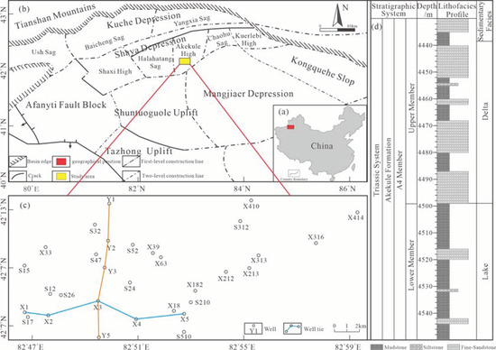
Figure 1.
Integrated geological characteristics of the Tahe Oilfield in the Tarim Basin, China. (a) Geographical location of the study area. The red rectangle marks the study region, situated in the Tarim Basin of northwestern China. (b) Geological structural map of the Tarim Basin. The yellow area represents the Tahe region, located in the southern part of the Akel Uplift and positioned within the marginal zone of the lacustrine basin. (c) Distribution of key well locations in the study area of the Tahe Oilfield. Orange and blue lines denote the well tie lines analyzed in this study. (d) Composite stratigraphic column and sedimentary facies distribution from the western part of the study area. The lower section comprises mudstone-dominated lacustrine facies deposits, while the upper section consists of deltaic deposits characterized by interbedded sandstone and mudstone with variable thicknesses.
The Triassic strata in the research area can be divided into three lithological groups according to sedimentary cycles: the lower Kotuer Formation (T3h) is mainly composed of alluvial fan braided river deposits; the central Akekule Formation (T2a) is further subdivided into the A 1 to A 4 Members, with the A 4 Member as the research object. The lithological combination is characterized by thick layers of dark gray lacustrine mudstone interbedded with thin layers of fine sandstone. The thickness of individual sand bodies is mostly less than 8 m and rapidly changes laterally, forming a typical “fault control lithology composite trap” reservoir structure.
3. Materials and Methods
This study utilizes a 3D seismic dataset provided by Sinopec Northwest Oilfield Company, covering an area of approximately 360 km2. The raw data underwent pre-stack time migration (PSTM) processing to enhance the signal-to-noise ratio, with an effective frequency band of 15–120 Hz (dominant frequency: 80 Hz) and a sampling interval of 2 ms. Based on the average seismic wave velocity of 4000 m/s in the fourth member, the vertical resolution was calculated to be 12 m. Additionally, logging data from over 130 exploration wells in the study area, including spontaneous potential (SP), gamma ray (GR), and deep induction resistivity (RILD) curves, were integrated for lithology calibration and sedimentary facies constraints.
Grain size data were analyzed using a combination of sieve analysis and sedimentation methods. The dried and disaggregated samples were passed through a 62.5 μm sieve to separate the coarse and fine fractions. The coarse fraction was subjected to sieve analysis using a series of standard sieves (e.g., 1 mm, 0.5 mm, 0.25 mm, and 0.125 mm) for sequential sieving. The residual mass retained on each sieve was weighed. For the fine fraction, sedimentation analysis was performed: the dried particles were mixed with a dispersant (sodium hexametaphosphate) solution, ultrasonically treated to ensure dispersion, and then transferred to a 1000 mL graduated cylinder. At specific time intervals, 10 mL of suspension was extracted from a depth of 10 cm using a pipette, dried, and weighed to calculate particle concentration at each time point. The settling velocity , where t is the settling time and h is the extraction depth, was substituted into Stokes’ law to derive the particle diameter: ; η: fluid viscosity (Pa·s); ρs, ρf: particle and fluid densities (kg/m3); g: gravitational acceleration (m/s2); h: settling height (m); t: settling time (s).
4. Results
4.1. Sedimentary Facies Indicators
4.1.1. Lithological Characteristics
In the working area, the thickness of the fourth member of the Triassic is approximately 100 m, with a stable distribution across the plane. Based on field observations of core samples from the study area, mudstones are mainly characterized by a dark gray color (Figure 2a), with some exhibiting gray-black and gray-green hues, while sandstones are predominantly light gray and gray-white (Figure 2b). Some sandstones appeared grayish-brown (Figure 2c) due to their oil and gas indications, and plant bands were observed in some mudstones (Figure 2d). In terms of lithological characteristics, the lower part of the fourth member is primarily composed of dark gray mudstone interbedded with thin layers of light gray fine sandstone and siltstone; the upper strata consist of varying thicknesses of dark gray mudstone, silty siltstone, gray siltstone, and light gray fine sandstone (Figure 1d), with sand bodies being notably thicker in certain local areas. The color of the rock core is mainly dark, reflecting a reducing environment of underwater sedimentation.
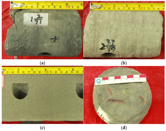
Figure 2.
Lithological characteristics of rock cores from the fourth member of the Triassic in Tahe Area. (a) The first coring of well S26 is 2/71, dark gray mudstone; (b) the second coring of X316 well 37/39, gray-white fine sandstone; (c) well Y3, 4565.6 m, grayish-brown oil-immersed fine sandstone; (d) the second coring 7/7 of S210 well, plant strip.
4.1.2. Sedimentary Structural Characteristics
The core shows that the sand body is mainly fine sandstone and siltstone. The sedimentary structures are rich, mainly including massive bedding (Figure 3a), parallel bedding (Figure 3b), wavy bedding, and low-angle cross-bedding (Figure 3c). Striped mud gravel (Figure 3d), severely fragmented layered carbon debris (Figure 3e), and highly rounded mud gravel (Figure 3f) can be seen in some fine sandstones. A few fine sandstones can be seen with seriously broken layered granular carbon chips (Figure 3e) and high-roundness mud gravel (Figure 3f).
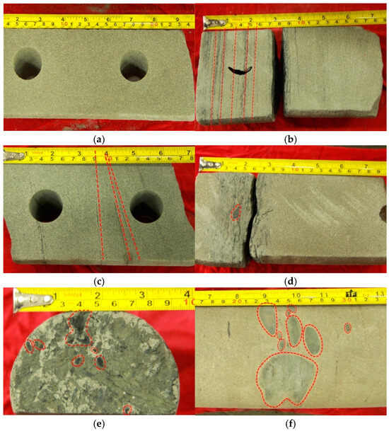
Figure 3.
Sedimentary structure of the fourth member of the Triassic formation in Tahe Oilfield. (a) Well Y3, 4566.6 m, massive bedding; (b) well X316, 4486.3 m, parallel bedding; (c) well Y3, 4569.6 m, small cross-bedding; (d) well S17, 4535.8 m, strip mud gravel; (e) well S17, 4537.4 m, granular carbon chips; (f) well X212, 4491.8 m fine sandstone with large mud gravel.
4.1.3. Particle Size Distribution
The cumulative probability curve of particle size in the study area is mainly two-stage. The rolling population is absent, while the jump and suspension populations dominate. The proportion of the suspension population ranges from 5% to 20% (Figure 4). The jump population exhibits a steep slope and good particle sorting. Morphologically, the jump population displays a two-segment pattern, with slight differences in median grain size and sorting between the two segments.
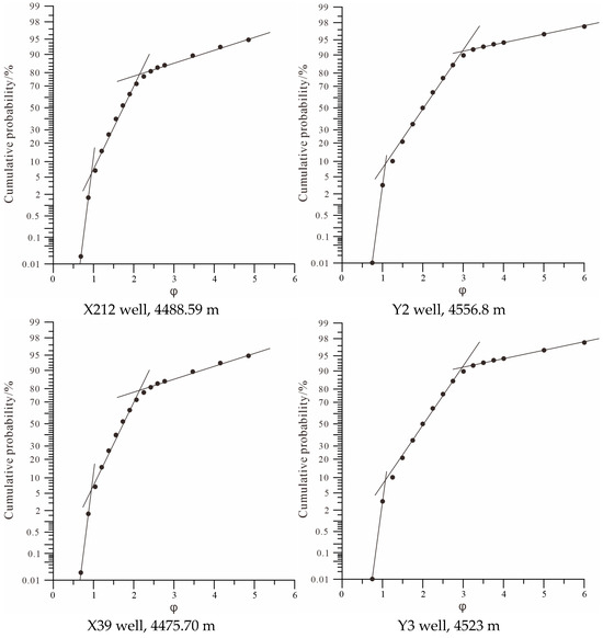
Figure 4.
Grain-size cumulative probability curves of shore–shallow lake sediments in the Tahe Region, Tarim Basin: implications for sedimentary processes and hydrodynamic conditions in a marginal lacustrine setting.
4.1.4. Characteristics of Phase Sequence Combination
Through core observations of wells Y2, S26, Y5, and X212, vertical lithological variations and sedimentary structures were analyzed, and a phase sequence histogram was constructed (Figure 5). The cores exhibit no distinct rhythmic layering. Sandstone is predominantly light gray (Figure 5 (Y5)), while argillaceous sediments are dark gray, with localized grayish-green intervals (Figure 5 (Y2)). Sedimentary structures include massive bedding, parallel bedding, and low-angle cross-bedding. Argillaceous laminations are present within fine sandstone layers (Figure 5 (S26)), and sandy laminations occur within argillaceous deposits (Figure 5 (X212)). Mud gravels are common at the base of fine sandstone units in wells S26, Y5, and S212, displaying well-rounded morphologies. The target sand body in well Y5 exhibits a weakly reverse-graded texture.
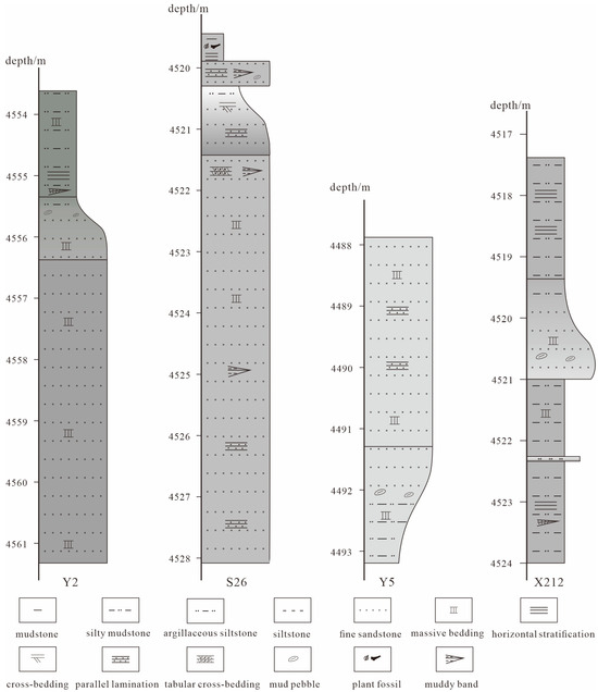
Figure 5.
The combination of shore–shallow lake facies sequences and cycles controlled by lake levels rising and falling in the fourth member of the Triassic in Tahe Oilfield.
4.2. Sand Body Distribution
4.2.1. Characteristics of Sedimentary Facies in Profile
Analysis of north–south and east–west sedimentary well profiles reveals the spatial distribution and continuity of sandstones in the study area. In the lower sandstone formation of the fourth member, thin sandstones dominate, with medium-thick sandstones locally present (Figure 6 (X3)). The north–south profile contains abundant thin sandstones (Figure 7 (Y2)), but adjacent wells show poor sandstone correlation. In contrast, the upper sandstone formation exhibits increased sandstone frequency, predominantly comprising discontinuous thin sandstones and isolated medium-thick sandstones. In the upper interval of wells X1 and X2 within the eastern profile, multistage stacked sandstone bodies are developed. The spontaneous potential (SP) log exhibits a box-shaped signature, with good inter-sand body correlation.
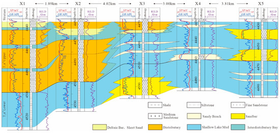
Figure 6.
Vertical comparison diagram of sand body superposition styles and sedimentary facies of E-W trending well tie profiles of fourth member of Triassic in Tahe Oilfield, Tarim Basin.
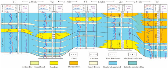
Figure 7.
Vertical comparison diagram of sand body overlay style and sedimentary facies of well tie profile in A-4 member of Triassic in Tahe Oilfield, Tarim Basin.
4.2.2. Plane Characteristics of Sand Body
Seismic reservoir prediction reveals that the lower sand layer of the fourth member is dominated by low-amplitude unstable reflections, while multiple nearly east–west-trending strong-amplitude stable reflections are developed (Figure 8). The southernmost strong-amplitude zone exhibits a significantly wider morphology. These strong-amplitude zones display subparallel banded geometries with stable widths (50–150 m) and high continuity (>15 km). Wells S47, S12, S52, S24, X63, X18, and S510 show consistently protruding southward and northward positions in seismic attributes (Figure 8). The western part of the study area contains small-scale north–south-oriented medium-strong stable amplitude reflections with bifurcation patterns.
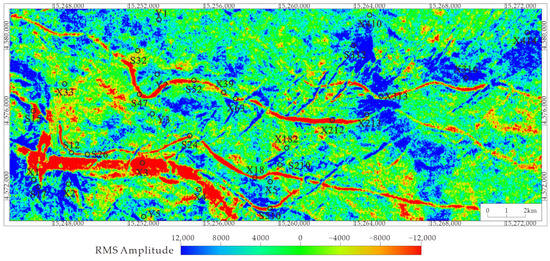
Figure 8.
Root Mean Square (RMS) amplitude attribute response to high-frequency lake-level fluctuations in the fourth member, Tahe Area.
The spatial scale of the high-amplitude stable reflection area in the upper sand layer of the fourth member has significantly increased (Figure 9). In the western part of the research area, high-amplitude stable reflections are developed, and the reflectors diverge in a fan-shaped manner towards the southeast, with obvious branching structures inside. High-amplitude stable reflections with a north–south distribution appear in the central and eastern regions. Multiple unstable strip-shaped high-amplitude reflections are developed in the central region. The southernmost region develops a large-scale east–west high-amplitude stable reflection, which exhibits a continuous transitional feature with the western high-amplitude zone.
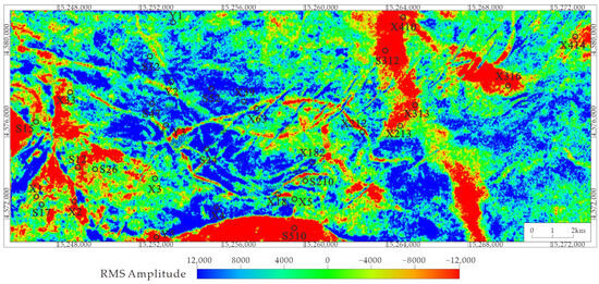
Figure 9.
Root Mean Square (RMS) amplitude response to lake-level falling in the fourth member, Tahe Area.
4.3. Modern Sedimentary Characteristics of Qinghai Lake
Qinghai Lake is the largest inland plateau lake in China. In addition to the delta depositional system, shore–shallow lake deposits are very developed, and sand beaches and sand bars are major features of shore–shallow lake deposits in Qinghai Lake. According to the satellite image of the South Bank of Qinghai Lake (Figure 10), a number of early-formed banded sand bodies are distributed along the lake bank, and these sand bodies are slightly curved, narrow, and stable in width, and are approximately parallel to the lake bank. At the same time, a number of small river channels from south to north can be seen on the South Bank of Qinghai Lake. Many sand bodies in triangular or oval accumulation areas can be seen in or around the center of these river channels (Figure 10).
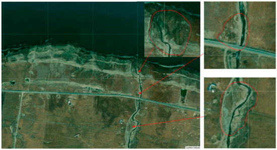
Figure 10.
Modern lacustrine sedimentary analog: depositional patterns of wave-modified sand bars and fluvial-dominated deltas in Qinghai Lake, Northeastern Tibetan Plateau ((Left): shore-parallel coastal sand bars; (Right): channel-associated deltaic sands).
In the satellite image of the South Bank of Qinghai Lake, we can observe some sand bodies with forks or ends pointing to the lake bank (South Bank) in some sand dams (Figure 11). The sand bar passing through well S510 in the lower sand layer group of the fourth member (left side of Figure 12) and the sand bar near well x316 in the upper sand layer group (right side of Figure 12) have the characteristics of pointing to the Northern Lake shore, which is basically consistent with the sand body morphology of the middle or end of the sand bar on the southern bank of Qinghai Lake pointing to the lake shore (Figure 12).
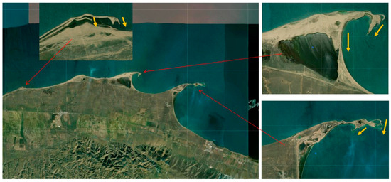
Figure 11.
Modern lacustrine sedimentary dynamics analog: shoreward-pointing cuspate sand bars and coastal sand bodies in Qinghai Lake, NE Tibetan Plateau—implications for paleoshoreline reconstruction (landward-oriented bar termini suggesting longshore current–wave interactions).
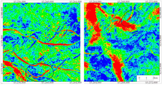
Figure 12.
The shoreward deflection of localized high root mean square (RMS) amplitude anomalies influenced by waves in lacustrine environments ((Left): shoreward deflection at the terminus of a band-shaped high-amplitude zone; (Right) shoreward deflection in the central part of a high-amplitude area).
5. Discussion
5.1. Sedimentary Environment Analysis
Based on the comprehensive analysis of rock cores, sedimentary structures, grain size characteristics, and seismic data, the overall sedimentary environment in the study area is a composite sedimentary system of shore–shallow lake delta fronts. The overall color of the rock core is relatively dark, and the well-preserved plant debris in the mudstone layer (Figure 2d) indicates that sedimentation occurred in an underwater hypoxic environment, transitioning from mainly mudstone sedimentation in the lower section to sandy sedimentation in the upper section, reflecting the overall environmental evolution of the study area’s water body to become lighter. Layered fragmented carbon debris (Figure 3e) and highly rounded mud gravel (Figure 3f) indicate that sediments have undergone long-distance transport and strong wave or coastal current alteration. The presence of massive bedding, parallel bedding, and low-angle cross-bedding, combined with the bidirectional current flow characteristics of local water movement and dual saltation of grain sizes reflecting scouring and backflow features, further supports a lacustrine shoreface wave-dominated sedimentary environment [20]. In the phase sequence combination analysis, it is shown that the circular mud gravel commonly distributed at the bottom of the sand body (S29, S39, S212 wells) is a stagnant sediment at the bottom of the river channel, reflecting the scouring effect of water flow on the underlying mudstone layer. The weak reverse rotation of the S39 well sand body also conforms to the sedimentary characteristics of sand bars in the shore–shallow lake facies.
The multiple sets of medium-thick sand bodies developed in the X1 and X2 wells in the eastern part of the study area have the characteristics of good vertical continuity and matched lithological combinations. Seismic slices show the reflection characteristics of the north–south branching river channels in the study area (Figure 9), and the logging curves are box-shaped, consistent with the sedimentary characteristics of the underwater distributary river sand bodies [21,22,23,24]. The continuous and stable reflection characteristics of earthquake amplitudes in the western and central–eastern regions are highly consistent with the spatial distribution of medium-thick sand bodies, suggesting that ancient rivers formed a bifurcated river system by flowing into the lake from north to south. Based on the comprehensive characteristics of lithology, structure, and seismic response, the sedimentary evolution of the study area can be divided into two stages: in the early stage, shallow lake sedimentation was the main form, with shallow lake mudstone mainly developed; in the later stage, the uplift of the lake basin edge or the advancement of material sources led to the shallowing of the water body, resulting in the development of strong hydrodynamic transformation of sandy sediments and presenting an overall composite sedimentary system of shore–shallow lake delta fronts, which is jointly controlled by river input and wave action.
5.2. Distribution of Sedimentary Facies Plane
The fourth member exhibits multiple near-east–west-trending banded sand bodies in its lower sandstone unit (Figure 8). These sand bodies maintain stable widths and show near-parallel alignment to the paleo-lake shoreline, with excellent sorting characteristics (Figure 4), strongly indicative of wave-reworked littoral sand bar deposits. Notably, the protruding positions of wells S47 and S12 (southward), S52 and S24 (northward), and X63, X18, and S510 (southward) demonstrate remarkable spatial consistency (Figure 8 and Figure 13), revealing localized control of basement micro-topography on sand bar morphology. In the western study area, moderate–strong stable amplitude seismic reflections with north–south orientation display bifurcation features. Sedimentary facies analysis of profiles suggests the development of a small-scale delta system in this region, providing substantial clastic sources for the formation of sand bars and beaches. During this depositional phase, fluctuating lake levels facilitated wave reworking of sediments, resulting in multiple shore-parallel sand bar deposits along the paleo-lake margin (Figure 13). The southernmost bar exhibits significantly greater width compared to others, located within the transitional zone between delta front and shore–shallow lacustrine environments. This unique geometry reflects combined fluvial input and lacustrine wave action, promoting both vertical accretion and lateral migration to form composite sand bars [25,26,27,28].
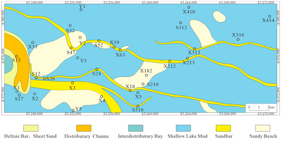
Figure 13.
The distribution characteristics of shore–shallow lake sedimentary facies in the lower sand formation of the fourth member of Tahe Oilfield.
During the late stage of the fourth member of deposition, lake-level fall induced significant reorganization of sand distribution patterns in the upper sandstone unit (Figure 14). Seismic reflections in western and central–eastern areas reveal fluvial distributive characteristics, with the western delta prograding southeastward and expanding its depositional footprint. A north–south-oriented delta system developed in central–western regions. The southernmost study area, connecting with the western delta lobe, accumulated abundant sandy sediments. Here, deltaic sands were reworked by lacustrine processes, ultimately forming a broad east–west trending sand bar through interconnected sand body stacking.
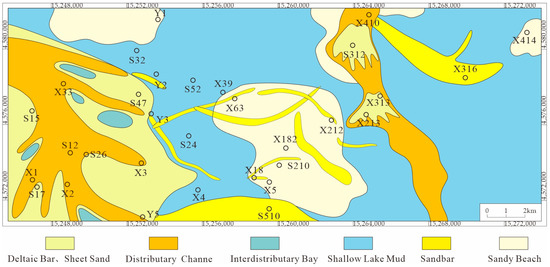
Figure 14.
Plane distribution of delta shore–shallow lake facies in the upper layer of the fourth member of the Triassic in Tahe Area, Tarim Basin.
5.3. Sedimentary Model of the Fourth Member of the Triassic Akekule Formation
Based on the description of sedimentary evolution characteristics and combined with the regional tectonic sedimentary background, the sedimentary model of the fourth member of the Triassic Akekule Formation in the study area is established (Figure 15). During the fourth member of the Akekule Formation of the Triassic, an alluvial fan sedimentary system was formed in the front of the Tianshan orogenic belt due to the uplift of the Northern Tianshan Mountains. Due to the lack of overall material supply during this period and the impact of climatic conditions, the rivers on the alluvial fan entered the low and gentle plain area in the form of meandering rivers, forming a river alluvial plane. Then, these meandering rivers entered the lake basin of the study area to form meandering river delta deposits, and provided clastic material sources for the sand bars and sand beaches of the shore–shallow lake [29,30]. When the lake level fluctuates frequently, strip-shaped sand bodies form along the lake shoreline [31]. The lake level continues to decline, forming underwater river channels and estuary sand bars. It can be seen from the sedimentary model map of the fourth member (Figure 15) that a relatively large delta depositional system is developed in the west of the study area, and a small channel delta depositional system is developed in the central–eastern region. Affected by lake waves, these delta sand bodies may be redistributed, forming a wide range of east–west strip sandbanks and locally developed irregular or elliptical sandbanks in the study area [32,33,34].
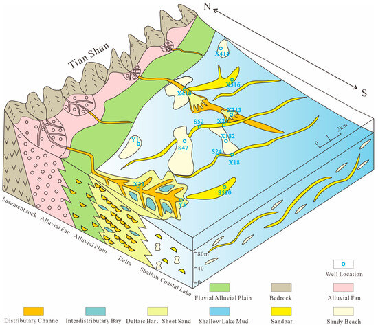
Figure 15.
High-frequency lake-level fluctuation-driven sedimentary evolution of shore–shallow lake facies: a case study from the fourth member of the Triassic in Tahe Area, Tarim Basin.
5.4. Significance of Oil and Gas Exploration
The fourth member of Tahe Formation is dominated by lithologic and fault lithologic oil and gas accumulation [35]. The significance of oil and gas exploration in this member is primarily associated with three key factors: (1) Superior reservoir architecture, characterized by the north–south channel sand body and east–west long belt sand bar in the western and central–eastern Tahe Oilfield. These sand bodies exhibit distinct advantages: shore–shallow lake sand bodies, particularly coastal sand bars, are repeatedly scoured by lake water, resulting in excellent porosity and permeability despite their low thickness; delta-front channel sand bodies show large single-layer thickness, high sand–mud ratios, and stacked development patterns, with feldspathic lithic sandstone cores dominated by intergranular pores. This dual-type reservoir system provides critical storage capacity and hydrocarbon migration pathways. (2) Fault-controlled migration pathways: NE-SW-trending en-echelon faults with large offsets penetrate Paleozoic source rocks, creating direct conduits for vertical hydrocarbon migration from deep source kitchens to shallower reservoirs. (3) Self-contained trap–seal assemblages: laterally pinched-out sand bodies form lithologic traps that integrate with regional caprocks, completing the essential “source–migration–reservoir–seal” petroleum system components [36,37].
These factors collectively define the exploration significance: the synergistic combination of high-quality reservoirs, effective fault conduits, and self-sealing traps creates optimal conditions for hydrocarbon accumulation. However, technical challenges persist due to NE-SW-trending secondary faults compartmentalizing sand bodies into isolated blocks with varying oil–water contacts, compounded by widespread muddy interbeds enhancing reservoir heterogeneity [38,39]. This geological complexity, reflected in poor lateral continuity observed in well correlations, underscores the necessity for advanced 3D geological modeling to optimize drilling strategies and improve recovery efficiency. Future research should prioritize high-resolution characterization of these interdependent factors—reservoir architecture, fault connectivity, and heterogeneity patterns—to fully exploit the member’s exploration potential.
6. Conclusions
- (1)
- The fourth member is dominated by shore–shallow lake subfacies deposits, with locally developed delta-front subfacies. In the early stage, under the control of the northwestern provenance, small-scale delta depositional systems developed, characterized by subaqueous distributary channel sands. Frequent lake-level fluctuations facilitated the reworking of sands by lake waves, forming stable sand bars nearly parallel to the lake shoreline. The planar distribution of these sand bars was jointly controlled by paleotectonic patterns and lake-level fluctuations, exhibiting strip-shaped or lenticular geometries. In the late stage, as lake levels declined, the delta deposition expanded, with subaqueous distributary channels extending southward and southeastward. Concurrently, new delta deposits emerged in the central–eastern part of the study area.
- (2)
- The formation of sand bodies in shore–shallow lake–delta facies is closely related to hydrodynamic conditions at the lake basin margin. Deltaic sand bodies are prone to reworking by lake waves and littoral currents, forming strip-shaped sand bar deposits distributed along the lake shoreline. This depositional model not only reveals the influence mechanisms of physical processes on sediment distribution in shore–shallow lake environments but also provides crucial reference cases for understanding sand body formation and distribution in analogous delta–lacustrine systems along foreland basin margins worldwide, particularly in environmental settings subjected to multiple lake transgression and regression cycles.
- (3)
- Early-stage sand bars along the shoreline were formed through reworking and redistribution by lake waves, exhibiting well-sorted grains and high porosity and permeability. Late-stage subaqueous distributary channel sands in the delta front experienced stacked development, resulting in greater thickness. Sand bodies pinch out into mudstones, forming lithologic traps that provide favorable conditions for hydrocarbon accumulation.
- (4)
- The NE-SW-trending major faults in the study area connect with Paleozoic hydrocarbon source rocks, forming efficient migration pathways. Combined with lithologic traps formed by sand pinch-outs, these features establish a “fault-controlled lithologic composite” hydrocarbon accumulation model, demonstrating significant exploration potential. However, the pervasive NE-SW-oriented secondary short-offset faults within the study area compartmentalize sand bodies, leading to complex internal reservoir architecture. Future research should prioritize unraveling the internal structure and heterogeneity of the fourth-member reservoirs, as these factors are critical for optimizing hydrocarbon exploration strategies.
Author Contributions
Conceptualization, Z.L. and Y.Y.; methodology, L.W.; formal analysis, H.W.; investigation, Z.L.; resources, Y.Y.; data curation, Q.L.; writing—original draft preparation, Z.L.; writing—review and editing, Y.Y.; supervision, L.W.; project administration, H.W.; funding acquisition, Y.Y. All authors have read and agreed to the published version of the manuscript.
Funding
This research was funded by the Hunan Provincial Natural Science Foundation of China, grant number 2023JJ30239, and the Scientific Research Fund of Hunan Provincial Education Department, grant number 23B0467.
Institutional Review Board Statement
Not applicable.
Informed Consent Statement
Not applicable.
Data Availability Statement
All data and materials are available on request from the corresponding author. The data are not publicly available due to ongoing research using a part of the data.
Acknowledgments
The Northwest China Petroleum Bureau, SINOPEC, is thanked for providing access to their geological data and permitting the publication of the results.
Conflicts of Interest
The authors declare no conflicts of interest.
References
- Zhang, Y.; Li, C. The Development Trend of Domestic Oil and Gas External Dependence. China Pet. Chem. Stand. Qual. 2023, 43, 124–126, (In Chinese with English Abstract). [Google Scholar]
- Kang, Y.C. The resource potential and exploration for oil and gas in the Tarim Basin. Pet. Sci. Bull. 2018, 3, 369–375, (In Chinese with English Abstract). [Google Scholar]
- Ding, Y.; Wang, Y.C.; Huang, J.W. Exploration actuality and countermeasure of the triassic oil reservoirs in tahe oilfield of the tarimbasisn. Pet. Geol. Exp. 2008, 30, 552–556, (In Chinese with English Abstract). [Google Scholar]
- Gu, W.L.; Li, W.; Geng, D.; Ma, D. Identification and prediction of thin oil layers (sand bodies): Aking the A 4 Member of the Triassic in the second area of Tahe Oilfield as an example. Sci. Technol. Eng. 2017, 17, 203–212, (In Chinese with English Abstract). [Google Scholar]
- Nuo, Q.; Huang, H.D. Thought and model of deep low amplitude structure interpretation: Taking Triassic in the ninth area of Tahe oilfield in Tarim Basin as an example. Oil Gas Technol. 2013, 35, 58–62+174, (In Chinese with English Abstract). [Google Scholar]
- Jing, D. Research on the sedimentary system and main controlling factors of T2a4 the Triassic in Tahe Oilfield. China Pet. Chem. Stand. Qual. 2017, 37, 176+178, (In Chinese with English Abstract). [Google Scholar]
- Song, B.; Wang, B.; Liu, X.Z.; Liu, S.Z.; Chen, X.G.; Lu, W.Z. Fenetic types and distribution rules of thin sand layers in the fourth member of Shaejie Formation in Shubei Area of the western sag, Liaohe Depression. Geol. Resour. 2021, 30, 698–706, (In Chinese with English Abstract). [Google Scholar]
- Ren, S.P.; Yao, G.Q.; Mao, W.J. Genetic Types and Superimposition Patterns of Subaqueous DistributaryChannel Thin Sandbodies in Delta Front: A case study from the IV-VI reservoir groups of H3 in Biqian 10 area of Gucheng oilfield. Acta Sedimentol. Sin. 2016, 34, 582–593, (In Chinese with English Abstract). [Google Scholar]
- Jamil, M.; Siddiqui, N.A.; Rahman, A.H.B.A.; Ibrahim, N.A.; Ismail, M.S.B.; Ahmed, N.; Usman, M.; Gul, Z.; Imran, Q.S. Facies Heterogeneity and Lobe Facies Multiscale Analysis of Deep-Marine Sand-Shale Complexity in the West Crocker Formation of Sabah Basin, NW Borneo. Appl. Sci. 2021, 11, 5513. [Google Scholar] [CrossRef]
- Basit, A.; Umar, M.; Jamil, M.; Qasim, M. Facies analysis and depositional framework of Late Permian-Jurassic sedimentary successions, Western Salt Range, Pakistan: Implications for sequence stratigraphic trends and paleogeography of the Neo-Tethys Sea. Kuwait J. Sci. 2023, 50, 1–22. [Google Scholar] [CrossRef]
- Liu, J.H.; Guo, R.; Ma, H.T.; Xia, B.Y.; Xian, W.; Jiang, A.M.; Ge, Z.J. A new understanding of the causes of the banded sand body in the fourth member of Akekule Formation, eastern Tahe Oilfield, Tarim Basin. Nat. Gas Geosci. 2019, 30, 1253–1262. [Google Scholar]
- Yang, M.; Liu, J.H.; Xian, W.; Guo, R.; Xia, B.Y. Description of the Boundary of Banded Sand Body in the Fourth Member of Akekule Formation in Eastern Tahe Oilfield, Tarim Basin. Xinjiang Pet. Geol. 2019, 40, 430–436, (In Chinese with English Abstract). [Google Scholar]
- Pszonka, J.; Sala, D. Application of the mineral liberation analysis (MLA) for extraction of grain size and shape measurements in siliciclastic sedimentary rocks. E3S Web Conf. 2018, 66, 02002. [Google Scholar] [CrossRef]
- Pszonka, J.; Godlewski, P.; Fheed, A.; Dwornik, M.; Schulz, B.; Wendorff, M. Identification and quantification of intergranular volume using SEM automated mineralogy. Mar. Pet. Geol. 2024, 162, 106708. [Google Scholar] [CrossRef]
- Nan, N. Research on High Resolution Sequence Stratigraphy and Reservoir Prediction—A Case Study from the 4th Member of Triassic Akekule Formation in Tahe oil Field. Master’s Thesis, Chengdu University of Technology, Chengdu, China, 2016. [Google Scholar]
- Zhu, M.H.; Guo, J.H.; Yong, T.W.; Wang, M.Y. Sequence stratigraphy of the Triassic in Akekule area, Tarim Basin and its control effect on the reservoir sandbody. J. Xi′Shiyou Univ. (Nat. Sci. Ed.) 2007, 22, 1–5+124. [Google Scholar]
- Guo, J.H.; Liu, C.S.; Zhu, R. Triassic sequence stratigraphy and genesis types of reservoir sand bodies in Akekule area. Acta Sedimentol. Sin. 2007, 25, 169–176, (In Chinese with English Abstract). [Google Scholar]
- Yu, Y.; Zhang, C.M.; Wang, L.; Li, S.H.; Hursthouse, A.; Huang, Y.R.; Cao, T.T. Sedimentary characteristics and genetic mechanism of a deep-water channel system in the Zhujiang Formation of Baiyun Sag, Pearl River Mouth Basin. Deep-Sea Res. Part I Oceanogr. Res. Pap. 2021, 168, 1–19. [Google Scholar] [CrossRef]
- Yu, Y.; Zhang, C.M.; Wang, L.; Hursthouse, A.; Li, S.H.; Huang, Y.R.; Cao, T.T. Sedimentary facies characterization of forced regression in the Pearl River Mouth basin. Open Geosci. 2022, 14, 208–223. [Google Scholar] [CrossRef]
- Yuan, J.; Liang, H.Y.; Tan, M.Y.; Cheng, X.J.; Dong, D.T.; Sun, M.J.; Gao, N.H. Sedimentary characteristics and forming conditions of beach-bar sandbodies in theupper fourth member of the Shahejie Formation in the south slope of the Huimin Sag. Oil Gas Geol. 2014, 35, 410–416, (In Chinese with English Abstract). [Google Scholar]
- Liang, H.G.; Xian, W.; Li, W.P. Identification and Description Technique for Ultra-Deep, Thin Reservoir, Narrow Channel Sand, Tahe Oilfied. Geol. Sci. Technol. Inf. 2015, 34, 180–183, (In Chinese with English Abstract). [Google Scholar]
- Xian, W.; Jing, S.Z.; Jian, D. Characteristics Analysis of the Triassic A-section Reservoir in TK7226 Well Area of Tahe Oilfield. China Pet. Chem. Stand. Qual. 2017, 37, 89–90+93, (In Chinese with English Abstract). [Google Scholar]
- Zeng, H.L.; Zhao, X.Z.; Zhu, X.M.; Jin, F.M.; Dong, Y.L.; Wang, Y.Q.; Zhu, M.; Zheng, R.H. Seismic sedimentology of sub-clinoformal shallow-water meandering river delta: A case from the Suning area of Raoyang sag in Jizhong depression, Bohai Bay Basin, NE China. Pet. Explor. Dev. 2015, 42, 621–632. [Google Scholar] [CrossRef]
- Abbas, A.; Zhu, H.T.; Zeng, Z.W.; Zhou, X.H. Sedimentary facies analysis using sequence stratigraphy and seismic sedimentology in the Paleogene Pinghu Formation, Xihu Depression, East China Sea Shelf Basin. Mar. Pet. Geol. 2018, 93, 287–297. [Google Scholar] [CrossRef]
- Xin, W.Y.; Bai, Y.C.; Xu, H.J. Experimental study on evolution of lacustrine shallow-water delta. Catena 2019, 182, 104125. [Google Scholar] [CrossRef]
- Dong, Y.L.; Zhang, M.Y.; Zhu, X.M.; Jiang, Q.; Guo, L.; Wei, M.P. Seismic geomorphology and depositional system of delta and terminal fan: A case study of the Neogene Shawan Formation in the Chepaizi Uplift, Junggar Basin, China. Mar. Pet. Geol. 2017, 83, 362–381. [Google Scholar] [CrossRef]
- Feng, G.; Xie, L.H.; Wang, J.; Zhang, W.P. T-R Sequence of sangonghe formation and deposition mode of depression lake basin in the hinterland of the junggar basin. Fresenius Environ. Bull. 2021, 30, 1441–1450. [Google Scholar]
- Li, H.T.; Luo, S.; Lu, X.L.; Wang, H.T.; Li, Z.; Cao, H.; Wang, G.J.; Li, Y. Discrimination of sedimentary system characteristics of the fourth member of shahejie formation in dongying sag, China. Fresenius Environ. Bull. 2020, 29, 481–489. [Google Scholar]
- Li, X.; Qiu, L.W.; Fu, J.; Dong, D.T.; Yang, Y.Q.; Khan, D.; Wu, Z.J.; Song, F.; Wen, X.; Liu, X.B. Architectural characteristics, evolutionary stages, and sedimentary models of clastic beach bars. Mar. Pet. Geol. 2022, 146, 105976. [Google Scholar] [CrossRef]
- Liao, J.B.; Xi, A.H.; Li, Z.Y.; Yang, J.; Di, J.; Long, L.W.; Zheng, X.M.; Yu, P.H. Identification, formation conditions and distribution regularity of beach bar sand bodies in major depression lake basins: A case study of the chang8 member in the ordos basin, China. Fresenius Environ. Bull. 2020, 29, 566–575. [Google Scholar]
- Liu, J.N.; Zhou, D.J. Scale characteristics and growth process of shallow water delta under different lake levels- based on Delft3D numerical simulation research. Front. Earth Sci. 2024, 12, 1489238. [Google Scholar] [CrossRef]
- Olariu, C.; Zhou, C.M.; Steel, R.; Zhang, Z.J.; Yuan, X.J.; Zhang, J.Y.; Chen, S.; Cheng, D.W.; Kim, W. Controls on the stratal architecture of lacustrine delta successions in low-accommodation conditions. Sedimentology 2021, 68, 1941–1963. [Google Scholar] [CrossRef]
- Yu, Y.; Cai, L.H.; Zhang, C.M.; Wang, L.; Zhu, R.; Huang, Y.R.; Cao, T.T. Sedimentary Sequence, Evolution Model and Pe-troleum Geological Significance of Forced Regression: A Case Study of the Miocene Zhujiang Formation of the Pearl River Mouth Basin in the Northern South China Sea. J. Mar. Sci. Eng. 2021, 9, 1298. [Google Scholar] [CrossRef]
- Zhang, R.L.; Liu, Y.; Jing, S.D.; Zhou, Y. Sedimentary features of gentle-slope tide-influenced braided delta: A case study of Carboniferous Kalashayi Formation in Tahe Oilfield. Sediment. Geol. Tethyan Geol. 2024, 44, 295–310. [Google Scholar]
- Liu, Y.L.; Hu, X.F.; Wang, D.X.; Zhao, Y.; Zhao, Q.; Wen, L. Characteristics of Triassic lithofacies palaeogeography in Tarim Basin. Fault-Block Oil Gas Field 2012, 19, 696–700, (In Chinese with English Abstract). [Google Scholar]
- Tong, Q.; Jiao, T.; Qi, Z.; Wang, H.H.; Liu, Y.C.; Zhu, Y.S.; Liu, H.L. Spatiotemporal evolution of single sandbodies controlled by allocyclicity and autocyclicity in the shallow-water braided river delta front of an open lacustrine basin. Open Geosci. 2021, 13, 98–121. [Google Scholar] [CrossRef]
- Yang, W.; Wei, G.Q.; Li, D.J.; Liu, M.C.; Xie, W.R.; Jin, H.; Shen, J.H.; Hao, C.G.; Wang, X.D. Geological characteristics and exploration prospect of oil and gas from the sandstone of the Silurian Xiaoheba Formation in the Sichuan Basin, China. J. Nat. Gas Geosci. 2020, 5, 129–141. [Google Scholar] [CrossRef]
- Xu, L.P. The Characteristics of Intelayers Distribution of Channel Sand Reservoir and Application of Horizontal Well in Tahe Oil Field. Geophys. Prospect. Pet. 2010, 49, 275–279+6, (In Chinese with English Abstract). [Google Scholar]
- Cheng, S.Y.; Deng, H.N.; Xian, W.; Deng, F. Triassic Channel Sand Body Identification and Efficient Well Placement in Tahe Oilfield. Xinjiang Pet. Geol. 2018, 39, 224–229, (In Chinese with English Abstract). [Google Scholar]
Disclaimer/Publisher’s Note: The statements, opinions and data contained in all publications are solely those of the individual author(s) and contributor(s) and not of MDPI and/or the editor(s). MDPI and/or the editor(s) disclaim responsibility for any injury to people or property resulting from any ideas, methods, instructions or products referred to in the content. |
© 2025 by the authors. Licensee MDPI, Basel, Switzerland. This article is an open access article distributed under the terms and conditions of the Creative Commons Attribution (CC BY) license (https://creativecommons.org/licenses/by/4.0/).