Article

Prediction of the Water-Bearing Properties of Weathered Bedrock Aquifers Based on Kernel Density Estimator–Bayes Discriminant

1
College of Geology and Environment, Xi’an University of Science and Technology, Xi’an 710054, China
2
Shenmu Ningtiaota Coal Mining Co., Ltd., Yulin 719300, China
*
Author to whom correspondence should be addressed.
Appl. Sci. 2025, 15(3), 1367; https://doi.org/10.3390/app15031367
Submission received: 11 December 2024 / Revised: 24 January 2025 / Accepted: 26 January 2025 / Published: 28 January 2025
(This article belongs to the Section Earth Sciences)

Abstract

:
The weathered bedrock aquifer in the Jurassic coalfield of northern Shaanxi Province is a direct water-bearing aquifer, and accurately predicting its water-bearing properties is essential for preventing and controlling water hazards in mining operations. Traditional Bayes discriminant methods have limitations in predicting water-bearing properties, particularly because not all primary factors influencing water-bearing properties meet the criteria for multivariate normal distribution. In this paper, the southern flank of the Ningtiaota Minefield is taken as an example, with the weathered bedrock aquifer as the research object. Six main controlling factors are selected: weathered bedrock thickness, core recovery rate, degree of weathering, lithological combination, elevation of the weathered bedrock surface, and sand-to-base ratio. A kernel density estimator–Bayes (KDE–Bayes) discriminant method for predicting water-bearing properties is presented. The kernel density estimation was carried out on the three main controlling factors that do not conform to a normal distribution—weathered bedrock thickness, core recovery rate, and sand-to-base ratio—and, in conjunction with other primary factors, a KDE–Bayes model was constructed for predicting the water-bearing properties in the southern flank of the Ningtiaota Minefield, based on which a detailed prediction of the water-bearing properties of the south flank of the Ningtiaota Minefield was conducted. By analyzing the actual dewatering data from the S1231 working face and past water inrush (or outburst) incidents, the feasibility and accuracy of this prediction method are demonstrated, providing valuable insights for predicting the water-bearing properties of weathered bedrock aquifers in the Ningtiaota Coal Mine and similar mining conditions.

1. Introduction

Coal, as the primary energy source in China, plays an essential role in economic and social development [1]. The Jurassic coal fields in northern Shaanxi Province represent a favorable development area for China’s coal resources, contributing significantly to the country’s energy strategy. However, with the high-intensity extraction of coal resources, water hazards in coal mines have become frequent, resulting in significant losses to public safety and national resources [2,3]. The Ningtiaota Minefield is located within the Jurassic coal fields in the northern region of Shaanxi Province, with an annual production capacity of 12 Mt/a. The working face S1210 is the first working face in the southern flank, approximately 6000 m in length and 300 m in width. On 30 May 2011, when the working face advanced to a depth of 61 m, a water inrush accident occurred at the roof, with an initial water inflow of up to 1300 m3/h [4]. It is inferred that the primary source of this water inrush was the weathered bedrock aquifer [5]. This aquifer exhibits varying water-bearing capacities, ranging from low to high, with uneven spatial distribution, posing a severe threat to the safe operation of the mine [6]. Therefore, it is crucial to study the water-bearing properties of the weathered bedrock aquifer in the southern flank of the Ningtiaota Minefield to guide the safe mining of the remaining working faces in the southern flank.
Significant work has been undertaken by researchers on methods for evaluating water-bearing properties. The pumping test method [7,8,9] is the main traditional method for evaluating the water-bearing properties of aquifers. However, most conventional water-bearing properties evaluation methods rely on relatively scarce hydrogeological boreholes. The high cost of these boreholes and their limited number result in insufficient coverage of the overall area, making it difficult to accurately reflect the uneven spatial distribution of water-bearing properties in aquifers. Therefore, it is very worthwhile to explore the establishment of a water-bearing properties evaluation system using the widely available geological exploration data in coal mines.
In recent years, with the rise of predictive models and computer machine learning, multifactor prediction methods have gradually become the mainstream approach for evaluating the water-bearing properties of aquifers. Wu Qiang, an academic at the China Academy of Engineering, proposed the “Three Maps—Double Prediction Method” for predicting the water inrush (or outburst) conditions of a roof plate through water-bearing zoning and rupture safety zoning [10]. Qiu Mei et al. selected the depth of the sandstone floor, brittle rock ratio, lithological structure index, fault strength index, and fault intersections and endpoints density as the main controlling factors and proposed a combined weighting method based on AHP-RS-MD to evaluate the water-bearing properties of a clastic rock aquifer of the coal seam roof [11]. The multifactor integrated evaluation method can assess water-bearing properties under the conditions of complex indicators and offer the advantages of being rapid and low-cost [12].
As a multifactor evaluation method, the Bayes discriminant has a wide range of practical applications in machine learning and has been gradually applied by scholars in water-bearing property prediction in recent years [13]. However, in traditional Bayes discriminant, it is necessary to consider whether each variable meets the multivariate normal distribution, which can lead to suboptimal classification results [14]. Therefore, this paper proposes using the kernel density estimation method to estimate the kernel density of the main control factors in the study areas that do not meet the normal distribution, solving the problem that the main control factors affecting the water-bearing properties fail to meet the normal distribution. Thus, the KDE–Bayes (kernel density estimator–Bayes) discriminant model was constructed to predict the water-bearing properties of the non-pumping test boreholes in the study area, providing reference value for the prediction of the water-bearing properties of weathered bedrock.

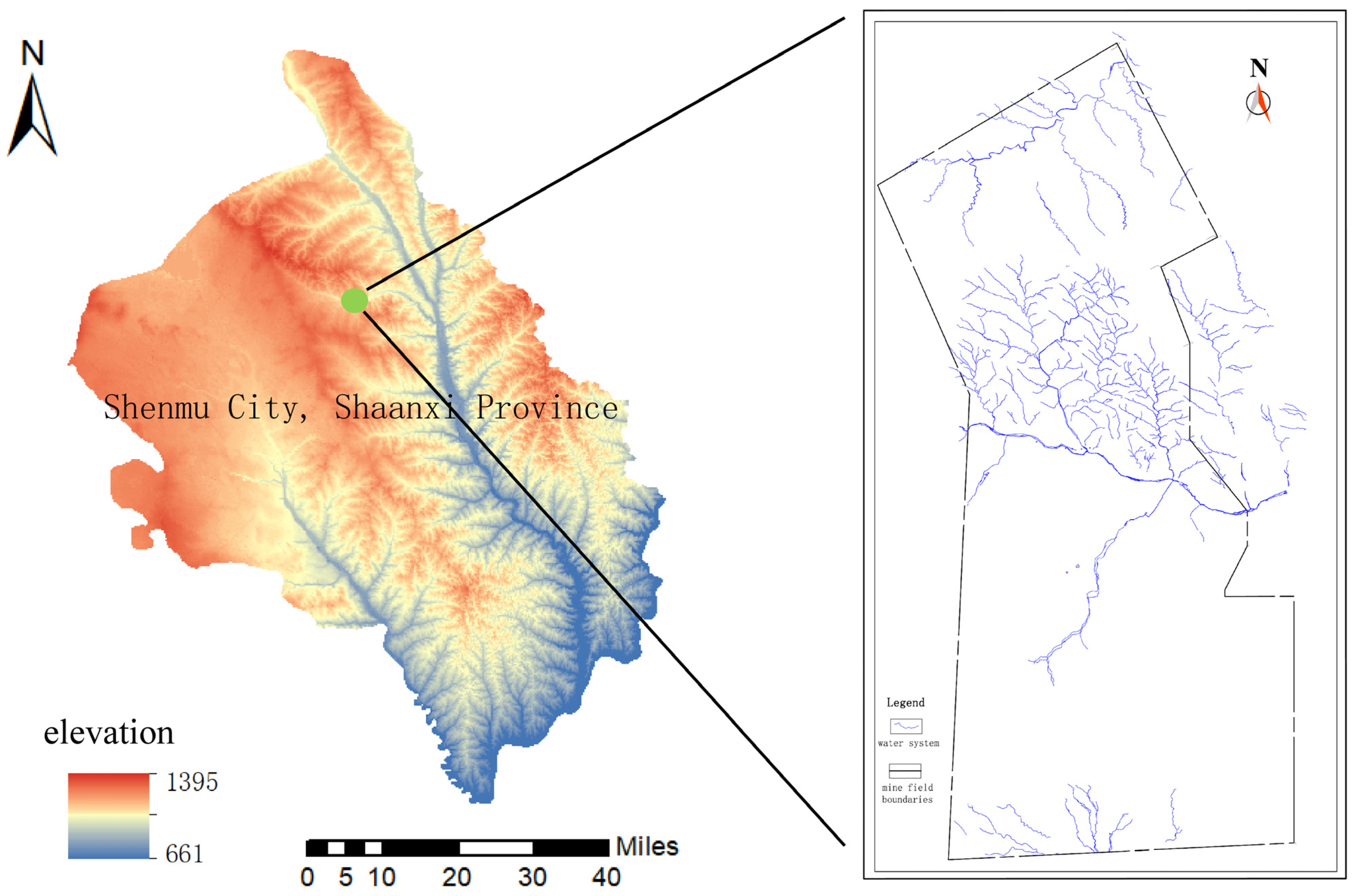
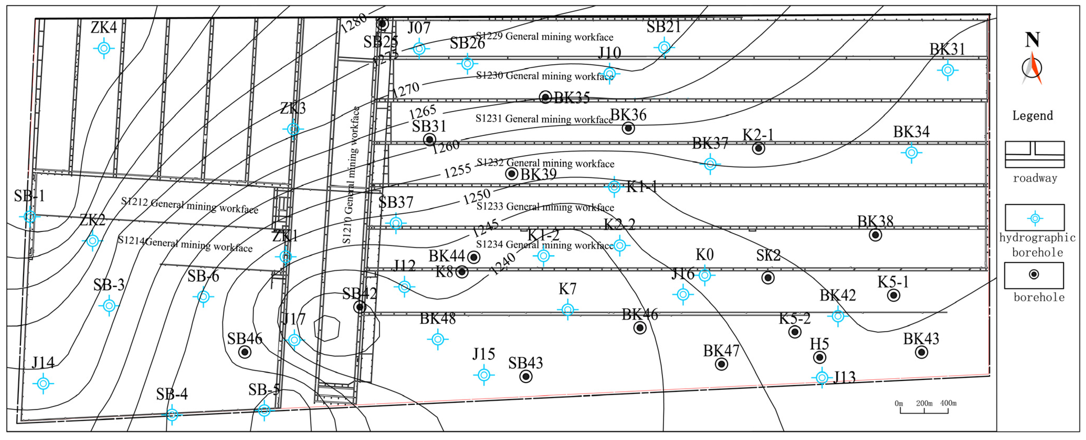
2. Overview of the Study Area

2.1. General Situation of Geology

The Ningtiaota Minefield is located in the southern part of the Shenfu Mining Area in northern Shaanxi Province (Figure 1). The Kaokao Wusu Trench divides the minefield into northern and southern flanks. The geomorphology of the southern flank is primarily composed of wind-blown sand, with the overall terrain sloping from high in the southwest to low in the northeast. According to the borehole data, the strata in the area, from oldest to youngest, are as follows: the Triassic Upper Yongping Formation (T3y), Jurassic Middle Yan’an Formation (J2y), Zhiluo Formation (J2z), Neoproterozoic Upper Neoproterozoic Baode Formation (N2b), Quaternary Middle Pleistocene Lishi Formation (Q2l), Quaternary Upper Pleistocene Salawusu Formation (Q3s), Quaternary Holocene wind-blown sand (Q4eol), and Alluvial Deposits (Q4al).

2.2. General Situation of Hydrogeology

The aquifers within the study area are mainly developed into two types: loose-layer pore aquifers and bedrock fracture aquifers. The bedrock fracture aquifer is further divided into weathered bedrock aquifers, normal bedrock aquifers of the Zhiluo Formation, and normal bedrock aquifers of the Yan’an Formation. The relative aquifers in the study area are the loess aquifer of the Lishi Formation and the red soil aquifer of the Baode Formation.
The weathered bedrock aquifer, the principal aquifer in the mine, is widely distributed in the southern flank of the minefield and is sporadically exposed in the area of the Kaukau Wusu Trench. Its lithology consists of a suite of yellow-green and grey-green medium-grained sandstones, sandy mudstones, and siltstones. According to the boreholes and pumping test data, the thickness of the weathered bedrock aquifer in the study area is 14.7~49 m, with an average thickness of 26 m; the permeability coefficient varies from 0.00342 to 1.4714 m/d; and the spatial distribution of water-bearing properties is uneven.

2.3. General Situation of the Coal Seam

The Yan’an Formation in the minefield contains nine minable coal seams, namely, 1−2 upper, 1−2, 2−2 upper, 2−2, 3−1, 4−2, 4−3, 5−2 upper, and 5−2. Among them, the main mineable coal seams are 1−2, 2−2, 3−1, 4−2, 4−3, 5−2 upper, and 5−2; 1−2 upper and 2−2 upper are the secondary mineable coal seams.
The main coal seam in the Ningtiaota mine field’s southern flank is the seam 2−2. This seam is significantly thicker in the southern flank, generally exceeding the thickness in the northern flank, with the maximum thickness exceeding 9 m. In most of the area, the thickness of the coal seam floor is stable, ranging from 3.7 m to 9.24 m, and the elevation of the coal seam ranges from +1112 m to 1165 m. This coal seam is medium-thick to thick, and the endowment area can be mined. The thickness of the minable coal seam varies greatly, yet its regularity is apparent, and the structure remains simple and stable.

3. Kernel Density Estimator–Bayes Discriminant

The KDE–Bayes discriminant, based on kernel density estimation, was proposed by Chen Xiangbing in 2015 [15]. The advantage of the KDE–Bayes discriminant over the traditional Bayesian discriminant is that it overcomes the condition that the data should follow a normal distribution [16].
For the KDE–Bayes discriminant, the unitary kernel function is defined as:
f ^ ( x ) = 1 n b i = 1 n K ( x x i b )
In this equation, b is the set bandwidth, n is the sample size, K ( ) is the kernel function, and x is the independent variable.
For data with large sample sizes, whichever form of kernel function is actually adopted, theoretically, it must eventually be possible to find a reliable result that converges to the density; generally speaking, a Gaussian kernel is used:
K ( u ) = exp ( 0.5 u ) 2 / 2 π
When the Gaussian kernel is chosen, according to Silverman’s Rule of Thumb (Efromovich, 2024 [17]), the bandwidth b is:
b ^ = 1.06 s · n 1 / 5
In this equation, s = j = 1 n i ( x j i x ¯ i ) 2 / ( n i 1 ) .
When the sample size is insufficient, if the number of samples in a certain category is small, the KDE may fail to effectively distinguish the densities between different categories, resulting in a decline in classification performance. Moreover, kernel density estimation depends on the section of smoothing parameters (e.g., bandwidth b ). A small sample size may lead to an inappropriate bandwidth choice, which can affect the quality of the density estimation and negatively impact the classification results.
After the kernel function K ( ) and bandwidth b are determined, the joint probability density of the samples x = ( x 1 , x 2 , , x m ) T can be estimated. Assume that each of its components x 1 , x 2 , , x m is a one-dimensional random variable, its probability density function takes the following form:
f ^ j ( x ) = 1 ( 2 π ) 2 n j b 1 b 2 b m · i = 1 n j exp 1 2 ( x 1 x i 1 ( j ) ) 2 b 1 2 + ( x 2 x i 2 ( j ) ) 2 b 2 2 + + ( x m x i m ( j ) ) 2 b m 2
In this equation, i = 1 , 2 , , n ; j = 1 , 2 , , k ; n = n 1 + n 2 + + n j .
The criterion for the KDE–Bayes discriminant is as follows:
If   P ( G i x ) = max 1 i k q i f ^ i ( x ) ,   x G i
In this equation, i = 1 , 2 , , k , and then x G i .

4. Construction of Discriminant Models

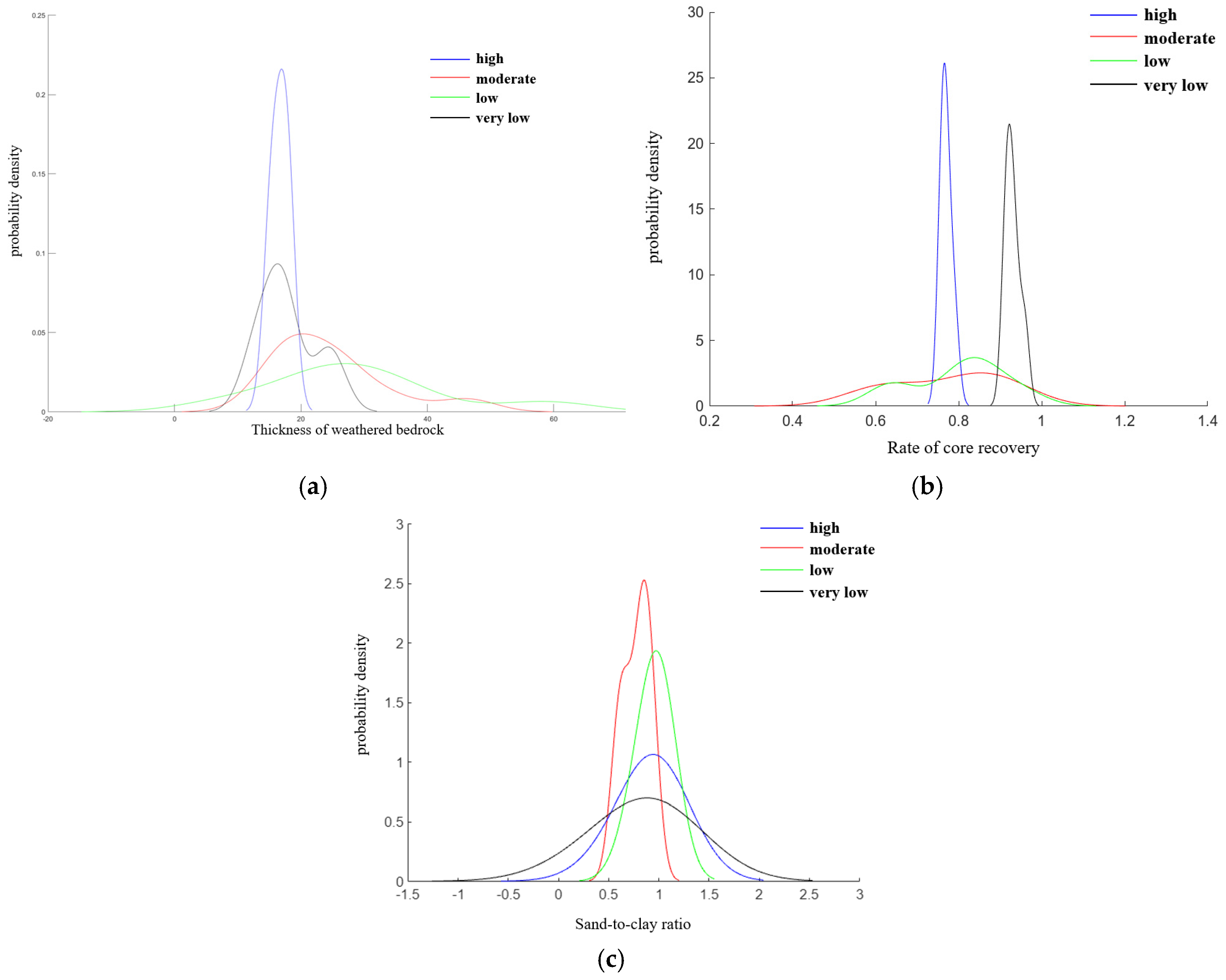
4.1. Selection of the Main Control Factors and Normality Test

According to the statistics, there are a total of 48 boreholes in the study area, including 30 hydrological boreholes and 18 coal exploration boreholes. The borehole distribution and water table contour map of the weathered bedrock aquifers in the study area is shown in Figure 2.
The Rules for Prevention and Control of Water in Coal Mines (2018) [18] stipulated the classification of aquifer water-bearing properties based on the water inflow per unit from the pumping tests of hydrological boreholes. The water-bearing properties of the aquifer are divided into four levels: very high, high, moderate, and low. Based on the pumping test results for weathered bedrock aquifers, the water-bearing properties in the study area range from low to high. Therefore, within the study area, the water-bearing properties can be further subdivided into four levels: high, moderate, low, and very low, and the water-bearing properties grading of the aquifer can be seen in Table 1.
The analysis of the development characteristics of weathered bedrock in the study area combined with the results of pumping tests and previous studies reveal that the water-bearing properties of the weathered bedrock aquifer are related to six quantitative indices, namely, the weathered bedrock thickness, the core recovery rate, the degree of weathering, the lithology combination, the elevation of the weathered bedrock surface, and the sand-to-base ratio.
1.
Weathered bedrock thickness
According to the results of previous research, with increasing weathered bedrock thickness, water-bearing properties first increase and then decrease [19], which is attributed to the fact that in boreholes with a large weathered bedrock thickness, the complexity of lithological combinations reduces the proportion of sandstones with better water-bearing properties;
2.
Core recovery rate
The core recovery rate is the ratio of the length of recovered core samples to the drilling depth. During the coring process, challenges such as core jamming, disturbance, and structural damage to the core may arise in loose and fractured formations, such as sand layers and gravel layers. These issues can result in low core recovery rates or failure to meet sampling requirements. However, the study area consists of dense sandstone, which eliminates the problem of gravel layers or weak rock formations.
Under consistent drilling lithology and coring techniques, a higher core recovery rate indicates a lower degree of fracture development, and the core samples are more complete. The higher the core recovery rate, the lower the degree of fracture development and the weaker the water-bearing properties of the rock formation. Conversely, a lower core recovery rate suggests stronger water-bearing properties.
For example, the boreholes J9 and SK1 have similar elevations of the weathered bedrock surface, lithology combination index, and weathering index. However, the core recovery rate index for J9 is 0.66, while for SK1, it is 0.936. As a result, the water inflow per unit of borehole J9 is 0.1117 L/(s·m), whereas for SK1, it is only 0.0108 L/(s·m). The core recovery rate is usually expressed as C :
C = C i · m i m i
In this equation, C represents the total recovery rate of the weathered bedrock layer, C i represents the core recovery rate corresponding to each drilling depth, and m i represents the drilling depth;
3.
Degree of weathering
Generally, the more intense the weathering of the bedrock, the more developed the rock fractures and the stronger the rock permeability [20]. In the study area, there is a positive correlation between the degree of weathering and water-bearing properties. The weathering degree of the bedrock in the area can be classified into three categories: weak weathering (I), moderate weathering (II), and strong weathering (III) (Table 2). The greater the degree of weathering, the better the water-bearing properties. For example, boreholes J15 and ZK2 have the same lithology combination and similar elevations of the weathered bedrock surface and core recovery rates. However, the water inflow per unit for J15 is 0.4461 L/(s·m), while for ZK2, it is 0.0626 L/(s·m). Analyzing the borehole lithology logs, the strongly weathered section of J15 extends to 16.3 m, whereas in ZK2, it is only 2.7 m. The cause of the difference in water-bearing properties is that after the rock undergoes weathering, its structure is damaged, and weathering fractures develop, resulting in increased permeability of the rock. On this basis, this paper uses the degree of weathering of weathered bedrock to portray the effect caused by the weathered layer on water-bearing properties, and the calculation formula is as follows:
w = w i · h i h i
where w is an indicator of the degree of weathering of the overall weathered bedrock; w i is the degree of weathering of different weathered rocks; and h i is the corresponding thickness of the rocks with varying degrees of weathering;
4.
Lithological combination
In aquifers, different lithologies have varying water-bearing capacities, and this is also true after weathering. Even among rocks of the same type, such as sandstones, different grain sizes can impact water-bearing properties differently. Generally, coarse-grained, medium-grained, and fine-grained sandstones have well-developed porosity and fractures, making them major water storage spaces in aquifers. In contrast, siltstones, sandy mudstones, and mudstones have tighter structures with less developed fractures, resulting in weaker permeability. For boreholes SK2 and J7 with the same weathering intensity, the water inflow per unit of SK2 is 0.1948 L/(s·m), while for J7, it is 0.0464 L/(s·m). The difference is because the lithology of SK2 is primarily medium-grained sandstone, while the lithology of J7 is dominated by fine-grained sandstone, with siltstone as a secondary component. Similarly, for boreholes K7 and BK49, which have the same elevation of the weathered bedrock surface and similar weathering degrees and core recovery rates, the water inflow per unit of K7 is 0.1380 L/(s·m), while for BK49, it is 0.0149 L/(s·m). The difference is attributed to the fact that the lithology of K7 is mainly medium-grained sandstone with coarse sandstone as a secondary component, whereas the lithology of BK49 consists mainly of medium-grained sandstone and siltstone, with sandy mudstone as a secondary component.
Accordingly, different types of weathered bedrock lithologies in the study area are assigned values, and a quantitative index of the lithological combination r is constructed (Table 3):
r = r i · n i n i
In this equation, r is an indicator of the lithological combination of the overall weathered bedrock; r i represents each rock type in the weathered bedrock layer; and n i describes the rock thickness corresponding to each rock type;
5.
Elevation of the weathered bedrock surface
The elevation of the weathered bedrock surface, which represents paleotopographic factors, has a significant impact on the water-bearing properties of the weathered bedrock. Overall, the water-bearing properties of the low-lying areas located on the top of the weathered bedrock are greater than that of the uplifted areas; under other similar controlling factors, the water inflow per unit is generally greater in the lower regions of the weathered bedrock top than in the higher areas of the weathered bedrock top surface. For boreholes BK42, K3-1, and BK28, the water inflows per unit are 0.1051, 0.1220, and 0.0050 L/(s·m), respectively. The corresponding elevations of the weathered bedrock surface are 1180.40, 1218.32, and 1242.62 m.
6.
Sand-to-base ratio
The sand-to-base ratio is the ratio between the weathered sandstone thickness and the total weathered bedrock thickness. Sandy mudstone and mudstone are prone to mudification phenomena in the process of weathering, and the mudstone and sandstone after mudification are relatively watertight compared with sandstone, which can weaken the hydraulic connection of the surrounding rock layers to a certain extent. Therefore, the sand-to-base ratio is a characterization index of the strength of vertical hydraulic connections in a weathered bedrock aquifer. Under the condition that other factors remain constant, the larger the sand-to-base ratio, the stronger the water-bearing properties. For example, in boreholes J12 and K1-2, where other factors are similar, the water inflow per unit is 1.0481 L/(s·m) and 0.004 L/(s·m), respectively. The sand-to-base ratio of J12 is 1, while that of K1-2 is 0.79.
Based on the aforementioned assigning principles, and combining the lithology logs of the boreholes, a statistical analysis was conducted on various indicators for the 30 hydrological boreholes in the study area. The statistical results are shown in Table 4. Based on these results, spatial variation maps of the indicators were generated in ArcGIS, as shown in Figure 3.
Normality test analysis can be used to analyze whether quantitative data have a normal distribution. The Shapiro–Wilk test is a method used to test whether a sample conforms to a normal distribution when the sample size is 8 ≤ n ≤ 50. This method is a non-parametric test that compares the means of two independent samples to determine whether they differ significantly. It does not rely on the normality assumption and is suitable for small samples or samples whose distributions do not satisfy the normality requirement.
Six quantitative indicators of the 30 pumping test boreholes were tested for normality based on the Shapiro–Wilk test in the IBM SPSS Statistics 26 software (Table 5), including borehole BK42 on the southern flank of the Ningtiaota Coal Mine.
From the table above, the weathered bedrock thickness, core recovery rate, and sand-to-base ratio are significant (p < 0.05), implying that the three main control factors do not have normal properties. The degree of weathering, lithology combination, and elevation of the weathered bedrock surface show p > 0.05, implying that these three principal controls have normal properties.

4.2. Kernel Density Estimates of the Main Controlling Factors

For primary factors that do not exhibit normality, kernel density estimation should first be performed. This study uses the Gaussian kernel function model as the kernel function for the density estimation, with the expression given by:
K ( u ) = 1 2 π e ( u 2 ) 2
In this equation, K ( u ) is the standard Gaussian kernel function.
The kernel density estimation model for each controlling factor is as follows:
f ( x , b ) = 1 N b i = 1 N K x a i b
In this equation, f ( x , b ) equals the kernel density estimation when the water-bearing properties category is x and the estimated kernel density at bandwidth is b ; a i is the control factor for borehole i ; and N is the sum of the main control factors under this water-bearing properties category.
On the basis of the above equation, the kernel density estimation function of the main control factors for different water enrichment types in the pumping test borehole was derived using MATLAB R2017b software. The results are shown in Figure 4.
Figure 4a shows that the distributions of the primary factors under different water-bearing property types exhibit significant variability, and the probability density distribution curve is basically consistent with typical normality. For weathered bedrock thickness, the peak values from the kernel density estimation align with the previously described pattern, where water-bearing properties first increase and then decrease with increasing thickness in both the high and very low water-bearing categories. For the core recovery rate, the peak values from the kernel density estimation are consistent with the previously noted trend that higher core recovery rates correlate with weaker water-bearing properties. Overall, the kernel density estimation performs well.

4.3. Construction and Validation of Discriminant Models

On the basis of the above analyses, the weathered bedrock thickness ( X 1 ), core recovery rate ( X 2 ), and sand-to-base ratio ( X 3 ) after kernel density estimation, as well as the degree of weathering ( X 4 ), lithology combination ( X 5 ), and elevation of weathered bedrock surface ( X 6 ), were selected as the six discriminants of KDE–Bayes. Thirty weathered bedrock pumping test boreholes in the area were randomly selected and allocated according to the principle of 3:1, i.e., 23 groups of training samples and 7 groups of validation samples. Discriminant analysis was carried out using SPSS software, and the actual results were compared with the results of the training model.
The discrimination steps are as follows:
(1)
Calculate the standard deviation and interquartile range of each component in the training dataset for each population category, and select the optimal bandwidth based on Equation (3);
(2)
Choose the form of the kernel function. For multivariate data, the Gaussian kernel function is generally selected. Combine Equations (3) and (4) to construct the kernel density estimation function f ^ j ( x ) for each population category;
(3)
Substitute the test dataset X j into Equation (5) using the kernel density estimation function f ^ j ( x ) to compute its posterior probability P ( G i x ) ;
(4)
Based on the maximum posterior probability rule, select the category with the highest posterior probability, and classify the test dataset into the corresponding category.
The KDE–Bayes discriminant function obtained from the 23 groups of training samples is as follows:
Y 1 = 1069.809 X 1 + 19920.468 X 2 + 377374.528 X 3 + 444.555 X 4 150.983 X 5 7.307 X 6 169010.698
Y 2 = 1921.359 X 1 + 18059.907 X 2 + 448348.457 X 3 + 559.468 X 4 186.074 X 5 8.736 X 6 248463.99
Y 3 = 1360.756 X 1 + 18402.975 X 2 + 384366.983 X 3 + 463.44 X 4 156.552 X 5 7.248 X 6 178927.035
Y 4 = 1118.553 X 1 + 18731.422 X 2 + 421791.124 X 3 + 509.609 X 4 170.557 X 5 8.66 X 6 205985.263
In this equation, Y 1 , Y 2 , Y 3 , and Y 4 represent very low, low, moderate, and high water-bearing properties, respectively.
After the actual water-bearing properties were compared with the training results (Table 6), the naive Bayes discriminant correctly predicted 82.6% of the samples in the 23 prediction groups and 71.4% of the samples in the 7 validation groups, and the overall positive judgment rate was 80%. KDE–Bayes discriminated 23 groups of the prediction group samples, and all the predicted results are consistent with the actual water-bearing properties. The anticipated results of the seven groups of validation samples are consistent with the actual water-bearing properties; the overall true positive rate is 100%. Comparing the KDE–Bayes discriminant results with the naive Bayes discriminant results, the true positive rate of the prediction group and validation group increased by 17.6% and 28.6%, respectively, and the overall true positive rate increased by 20%, which is a significant improvement.
The above results show that the KDE–Bayes discriminant model has greater accuracy than the traditional naive Bayes discriminant model, which can be used to predict the water-bearing properties type of boreholes without pumping tests in the area and improved the accuracy of the water-bearing property zoning results.

5. Zonation Prediction of the Water-Bearing Properties of the Weathered Bedrock in the Study Area

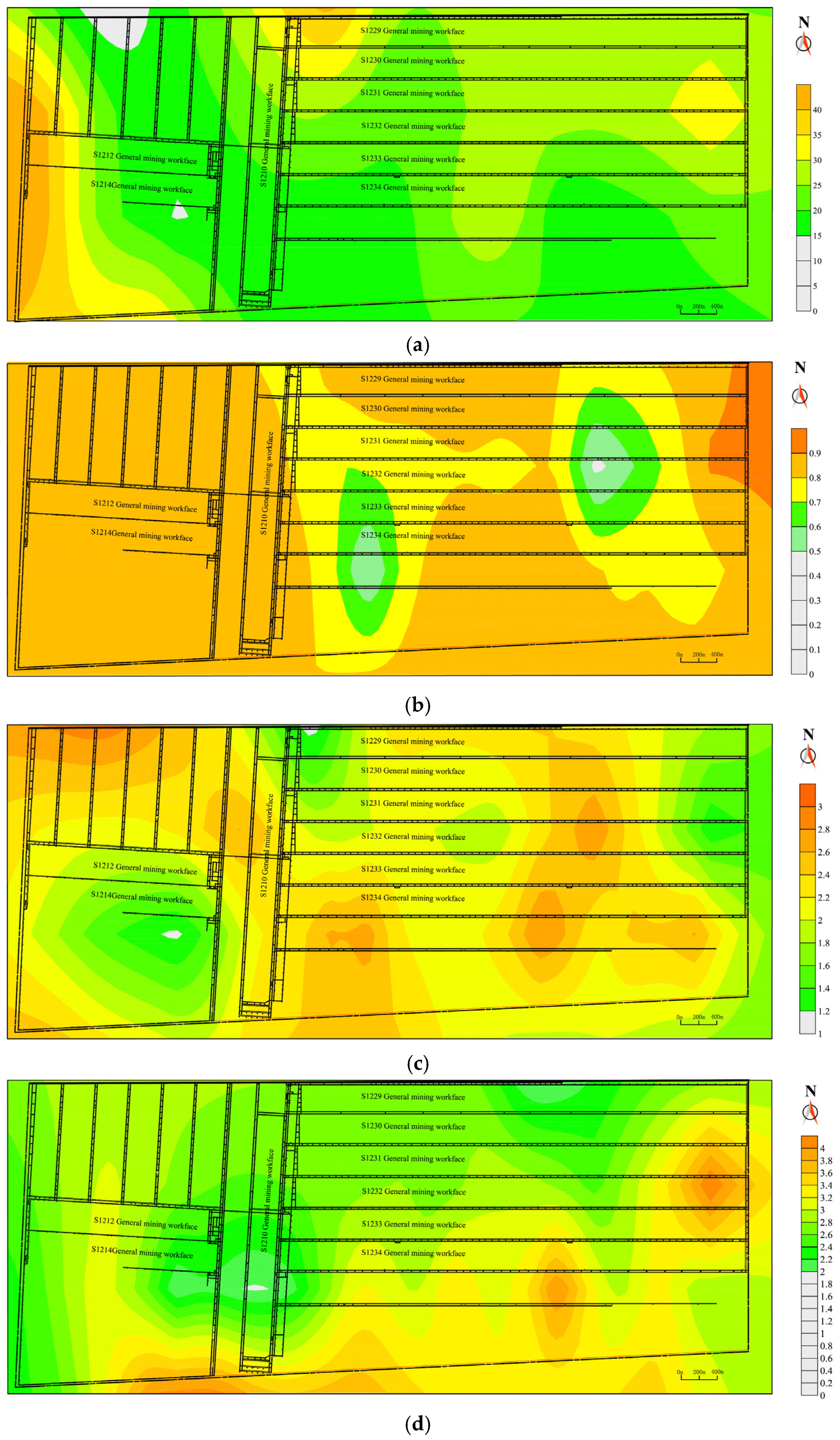
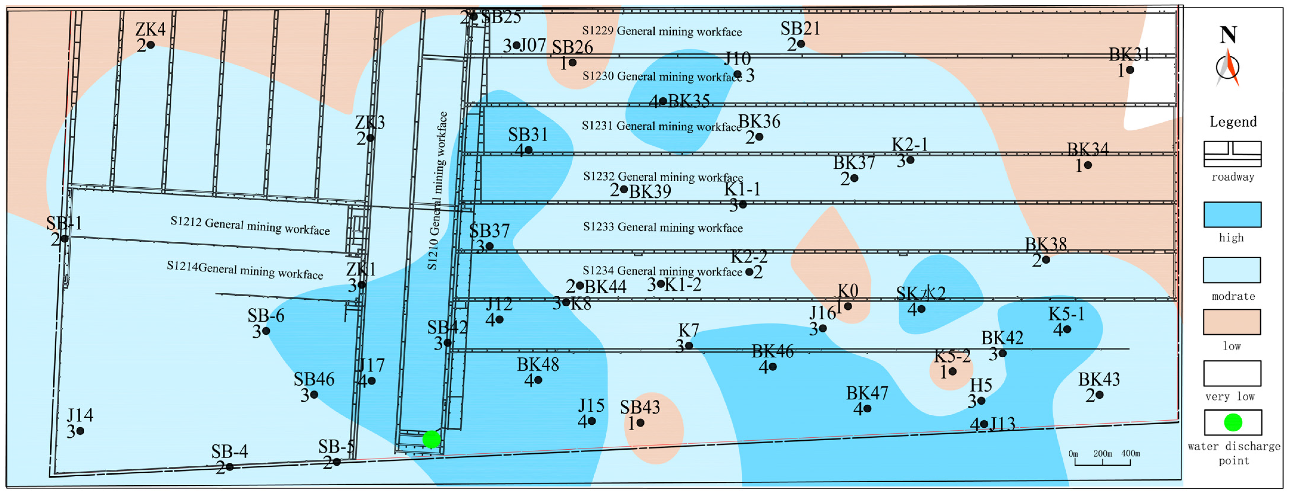
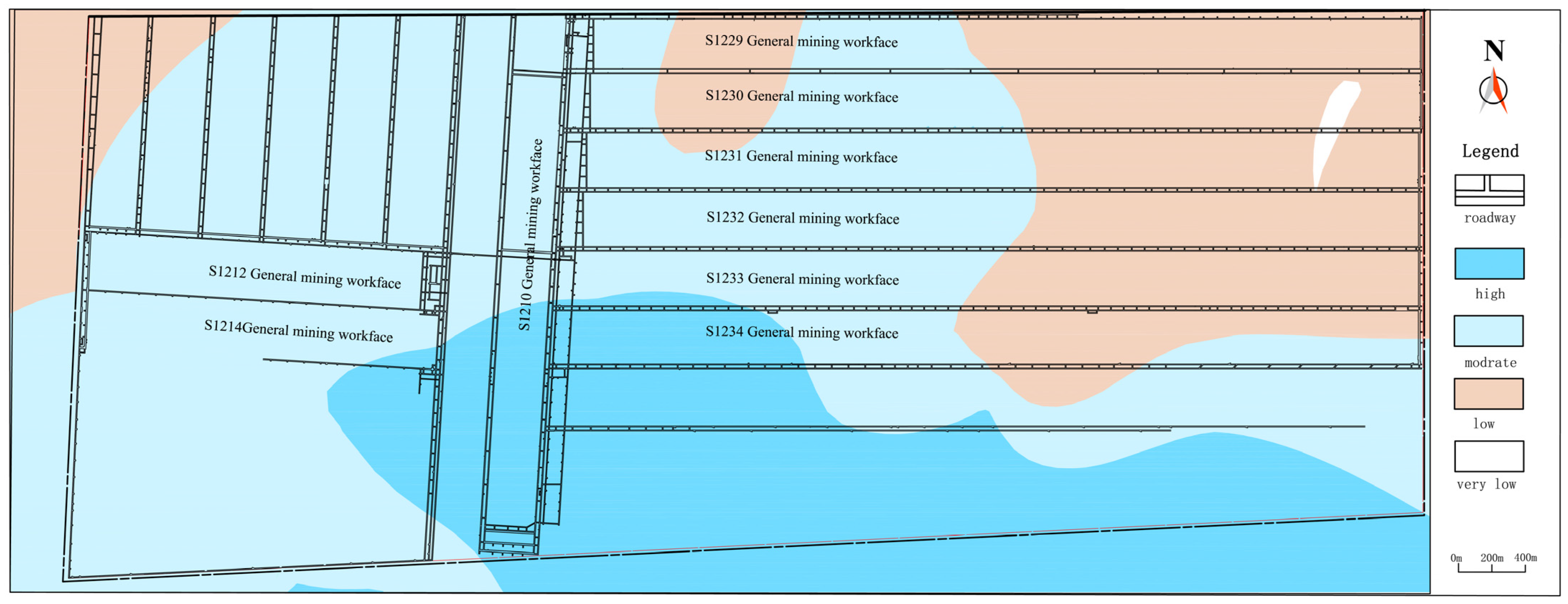
5.1. Results of the Zonation Prediction of Water-Bearing Properties

The Bayes discriminant method is based on the maximum a posteriori (MAP) rule and the minimum probability of misclassification as the discrimination criteria. It determines the water-bearing type by calculating the Bayes discriminant function for each water-bearing type. According to the rule of the MAP of the Bayes discriminant function, the main control factors are substituted into the four discriminant equations, and the type corresponding to the maximum function value is identified as the water-bearing type of the borehole.
Therefore, the predictive indicators for the non-hydrological boreholes in the study area were, respectively, substituted into the discriminant functions of Y 1 , Y 2 , Y 3 , and Y 4 , where Y max represents the water-bearing property type of the corresponding borehole (Table 7). By interpolating with the existing pumping test boreholes, the zonation prediction map of the water-bearing properties of the weathered bedrock on the southern flank of the Ningtiaota Coal Mine was obtained (Figure 5).
As shown in Figure 5, the water-bearing properties of the weathered bedrock in the study area range from very weak to strong. The strong water-bearing zones are mainly distributed near the S1210 working face, concentrated in the southern part of the study area. The moderate water-bearing zones are widely and continuously distributed in the central part of the study area. The weak water-bearing zones are primarily located in the northern part of the study area, with sporadic distributions also in the central and southern parts. The very weak water-bearing zones are found in the northeastern corner of the study area. Overall, the water-bearing properties in the study area exhibit significant variation, indicating an uneven spatial distribution of the water-bearing capacity of the weathered bedrock aquifer.
By interpolating the unit water inflow of the hydrological boreholes, the water-bearing zonation map of the weathered bedrock was drawn (Figure 6). Comparing the water-bearing zonation prediction map with the actual zonation map, it can be seen that in the western region, where the proportion of hydrological boreholes is relatively high, the predicted and zoning results are largely consistent. In the eastern region, where the proportion of hydrological boreholes is lower, after incorporating the water-bearing predictions for non-hydrological boreholes, areas with high, moderate, low, and very low water-bearing properties show varying degrees of change. The prediction results obtained using the KDE–Bayes discriminant method are more refined and better reflect the spatial distribution patterns of the water-bearing properties in the study area.

5.2. Validation of Water-Bearing Property Partition Predictions

(1) Verification of the water evacuation boreholes
Among the recently mined working faces in the southern flank of the Ningtiaota Coal Mine, working faces S1232, S1233, and S1234 are strongly affected by the burnt rock aquifer, and working face S1231 is affected only by the weathered bedrock aquifer. Therefore, this paper combines the downhole water evacuation data of the working face S1231 to verify the accuracy of the water-bearing property zoning through the measured data of water inflow from the downhole water evacuation boreholes. On the basis of the fine zonation prediction of the water-bearing properties of weathered bedrock and the results of water-bearing properties zoning, working face S1231 is divided into three types of water-bearing properties zones: type ① belongs to the high water-bearing properties zone; type ② belongs to the moderate water-bearing properties zone; and type ③ belongs to the low water-bearing zone. The water-bearing property zoning and the layout map of the pumping test boreholes are shown in Figure 7.
According to the initial water inflow of each drilling site, there are eight boreholes with an initial water inflow q of ≥40 m3/h, among which there are six boreholes located in type ①, and the borehole with the largest initial water inflow in the high water-rich zone is T18, with an initial water inflow of 75 m3/h. The average water inflow of the water evacuation boreholes in the high water-rich zone is 31.63 m3/h. Most water evacuation boreholes within type ② have an initial water inflow q between 10 and 40 m3/h, and only boreholes T33 and T31 have an average water inflow of 20.47 m3/h in the moderately water-rich zone. The initial water inflow of the evacuation boreholes in type ③ is less than 20 m3/h, and the average water inflow of the evacuation boreholes in the low water-bearing properties zone is 12.43 m3/h. The initial water inflows of the three zones are consistent with the results of the predicted water-bearing properties;
(2) Verification of the water inrush point: At the water discharge point of the S1210 working face, a water inrush incident occurred on the roof (Figure 5). This working face is the first working face on the southern flank, approximately 6000 m in length and 300 m in width. On 30 May 2011, when the working face had advanced to a depth of 61 m, a sudden water inrush accident occurred, with an initial inflow rate as high as 1300 m3/h. The water source for the inrush was primarily the confined water from the weathered bedrock fractures of the overlying Zhiluo Formation, which is consistent with the high water-bearing property of the weathered bedrock in this region;
(3) Hydrological borehole pumping test verification in adjacent mines
The Hongliulin Minefield is located in the south of the Ningtiaota Minefield, with its boundary adjacent to the Ningtiaota mining area, and the two minefields share similar geological conditions, making it possible to use the hydrogeological data from the Hongliulin mining area to verify the accuracy of the model. Ten hydrogeologic boreholes within the Hongliulin Minefield were randomly selected to predict their water-bearing properties, and the predicted results were compared with the actual water inflow, and the results are as follows (Table 8):
Comparing the actual water-bearing properties of the hydrological boreholes in the Hongliulin Minefield with the prediction results, the KDE–Bayes discriminant prediction model achieved an 80% prediction accuracy for the 10 sample sets. The predicted results are in good agreement with the actual results, demonstrating that the model still holds reference value in mining areas with similar geological conditions.
In conclusion, the water-bearing zonation prediction results are in good agreement with the actual outcomes, indicating that the model has high accuracy and provides a valuable reference for the prediction of the water-bearing properties of the weathered bedrock in the southern flank of the Ningtiaota Coal Mine and surrounding mines.

6. Conclusions and Prospects

6.1. Conclusions

(1)
Aiming at the traditional Bayes discriminant, which needs to consider whether all the variables in each formation satisfy the multivariate normal distribution, the kernel density estimation method is proposed for factors that do not conform to normality, leading to the development of a KDE–Bayes discriminant model;
(2)
The KDE–Bayes discriminant analysis model was constructed through existing hydrological borehole pumping test data. Comparing the naive Bayes discriminant model and the KDE–Bayes discriminant model, the KDE–Bayes discriminant model offers higher accuracy and reliability. The obtained water-bearing properties zoning reveals that the high water-bearing properties zone is distributed mainly around working face S1210 and is concentrated in the southern part of the minefield; the moderate water-bearing properties zone is widely distributed in the central part of the study area; the low and the extremely low water-bearing properties zone are mainly found in the northern part of the study area, with scattered occurrences in the central and southern parts of the study areas; and the water-bearing properties of the weathered bedrock aquifer is unevenly distributed;
(3)
The water-bearing prediction results were validated based on the water evacuation data and water inrush point information from the S1210 working face. The predicted results are in good agreement with the actual outcomes. This indicates that the model has high accuracy and provides a valuable reference for the prediction of the water-bearing properties of the weathered bedrock in the southern wing of the Ningtiaota Coal Mine and surrounding mines.

6.2. Prospects

At present, significant progress has been made by numerous scholars in using multi-factor discriminant methods to predict aquifer properties, with broad development prospects. However, there are still certain shortcomings. For example, in this study, a considerable amount of time and effort was spent on foundational work and raw data statistics. It is worth exploring how advanced tools, such as AI, can be utilized for data statistics and computation. Additionally, the model in this study lacks autonomous learning capabilities. Therefore, after deeper interdisciplinary integration, more complex kernel functions can be applied to improve the accuracy and generalization of the prediction model, enabling it to continuously enhance its predictive ability based on new data.

Author Contributions

Conceptualization, methodology, and writing—original draft preparation, E.H. and J.H.; data curation, L.M.; validation, T.H.; software, Q.Z.; supervision, L.G. (Lijun Gao) and L.G. (Liang Gao); All authors have read and agreed to the published version of the manuscript.

Funding

This research was funded by the National Natural Science Foundation of China (No. 42177174).

Data Availability Statement

The data are based on an overview map of the study area provided by Shenmu Ningtiaota Coal Mine Wild Release.

Acknowledgments

The authors would like to express their thanks to the Shenmu Ningtiaota Coal Mine for their support in this work.

Conflicts of Interest

Authors Liang Ma, Qi Zhang, Lijun Gao and Liang Gao were employed by the company Shenmu Ningtiaota Coal Mining Co., Ltd. The remaining authors declare that the research was conducted in the absence of any commercial or financial relationships that could be construed as a potential conflict of interest.

References

  1. Wang, T.; Han, X.; Sun, Y.; Li, Z.; Mao, S.; Lin, Z.; Li, C.; Zhao, X.; Sun, J.; Song, H.; et al. Orientation and major research problems of coal geological exploration in China under new conditions. Coal Geol. Explor. 2023, 51, 27–44. [Google Scholar]
  2. Zeng, Y.; Zhu, H.; Wu, Q.; Guo, X.; Pang, Z.; Liu, S.; Yang, W. Research status and prevention and control path of coal seam roof water disaster in China. J. China Coal Soc. 2024, 49, 1539–1555. [Google Scholar] [CrossRef]
  3. Guo, S.; Wang, H. Research on hydrogeological structural characteristics and water hazard control mode of Ningtiaota Coal Mine. China Min. Mag. 2024, 33, 190–200. [Google Scholar]
  4. LI, J. Application of Curtain Grouting Technology on Water In rush Control in Ningtiaota Coal Mine. Coal Technol. 2016, 35, 203–205. [Google Scholar] [CrossRef]
  5. Ji, Z. Analysis on Water Inrush Condition of S1210 Working Face in Ningtiaota Coal Mine. Coal Mine Saf. 2014, 45, 188–191. [Google Scholar] [CrossRef]
  6. Zeng, Y.F.; Li, Z.; Gong, H.J.; Zheng, J. Water abundance characteristics in aquifer of weathered roof bedrock and prediction on water inrush risk. Coal Eng. 2018, 50, 100–104. [Google Scholar]
  7. Shi, L.; Yu, L.; Jin, H.; Xiao, Y. Water Richness Evaluation of Coal Roof Aquifers Based on the Game Theory Combination Weighting Method and the TOPSIS Model. Mine Water Environ. 2024, 43, 691–706. [Google Scholar] [CrossRef]
  8. Qu, X.; Han, J.; Shi, L.; Qu, X.; Bilal, A.; Qiu, M.; Gao, W. An extended ITL-VIKOR model using triangular fuzzy numbers for applications to water-richness evaluation. Expert Syst. Appl. 2023, 222, 119793. [Google Scholar] [CrossRef]
  9. Sun, Z.; Bao, W.; Li, M. Comprehensive water inrush risk assessment method for coal seam roof. Sustainability 2022, 14, 10475. [Google Scholar] [CrossRef]
  10. Wu, Q.; Huang, X.; Dong, D.; Yin, R.; Li, J.; Hong, Y.; Zhang, H. Evaluation of coal seam roof water surge (sudden) conditions three diagrams-double prediction method. J. China Coal Soc. 2000, 62–67. [Google Scholar] [CrossRef]
  11. Qiu, M.; Shao, Z.; Zhang, W.; Zeng, Y.; Yin, X.; Gai, G.; Han, Z.; Zhao, G. Water-bearing properties evaluation method and application of clastic rock aquifer in mining seam roof. Sci. Rep. 2024, 14, 6465. [Google Scholar]
  12. Lv, Z.; Meng, F.; Lv, W.; Li, N. Improved Method for Predicting and Evaluating Water Yield Property. Coal Technol. 2023, 42, 152–155. [Google Scholar] [CrossRef]
  13. Hou, E.; Yan, X.; Zheng, Y.; Yang, F. Application of Bayes discriminant model in prediction of water enrichment of weathered bedrock. J. Xi’An Univ. Sci. Technol. 2019, 39, 942–949. [Google Scholar] [CrossRef]
  14. Nie, Q. Improvement of Bayesian Discriminant Method and its Application Study. Master’s Thesis, Guilin University of Technology, Guilin, China, 2022. [Google Scholar]
  15. Chen, X. Bayes Multivariate Discriminant Method Based on Kernel Density Estimation. Math. Pract. Theory 2015, 45, 185–189. [Google Scholar]
  16. Ushikoshi, T.A.; Freitas, E.J.R.; Menezes, M.; Junior, W.J.; Torres, L.C.; Braga, A.P. Hebbian Learning with Kernel-Based Embedding of Input Data. Neural Process. Lett. 2024, 56, 250. [Google Scholar] [CrossRef]
  17. Efromovich, S. Non-parametric density estimation over its unknown support for right censored data. Stat. Probab. Lett. 2024, 209, 110084. [Google Scholar] [CrossRef]
  18. Rules for Prevention and Control of Water in Coal. State Administration of Coal Mine Safety. 2018. Available online: https://www.gov.cn/zhengce/zhengceku/2018-12/31/content_5448431.htm (accessed on 5 December 2024).
  19. Hou, E.; Yang, S.; Miao, Y.; Che, X.; Yang, L.; Lu, B.; Xie, X.; Wang, H.; Dang, B. Prediction of water enrichment of weathered bedrock based on Bayes discriminant model. Saf. Coal Mines 2023, 54, 180–187. [Google Scholar] [CrossRef]
  20. Bai, Y.; Niu, C.; Li, F.; Xiang, M.; Zhao, S. Water abundance evaluation of weathered bedrock aquifers based on FAHP and coefficient of variance method. Saf. Coal Mines 2023, 54, 143–149. [Google Scholar] [CrossRef]
Figure 1. Map of Ningtiaota Coal Mine location.
Applsci 15 01367 g001
Figure 2. Map of borehole distribution and water table contours of the weathered bedrock aquifers in the study area.
Applsci 15 01367 g002
Figure 3. Spatial change in water rich prediction index. (a) Weathered bedrock thickness index. (b) Core recovery rate index. (c) Weathering degree index. (d) Lithology combination index. (e) Elevation of weathered bedrock surface index. (f) Sand-to-base ratio index.
Applsci 15 01367 g003aApplsci 15 01367 g003b
Figure 4. Kernel density estimation map. (a) Kernel density estimation for weathered bedrock thickness. (b) Kernel density estimation for the core recovery rate. (c) Kernel density estimation for sand-to-base ratio.
Applsci 15 01367 g004
Figure 5. Zonation prediction map of the water-bearing properties of the weathered bedrock in the study area.
Applsci 15 01367 g005
Figure 6. Water-bearing properties of the weathered bedrock zonation map.
Applsci 15 01367 g006
Figure 7. Water-bearing property zoning of working face S1231 and layout map of the underground pumping test boreholes.
Applsci 15 01367 g007
Table 1. Classification of the water-bearing properties of aquifers.
Water-Bearing Property ClassificationHighModerateLowVery Low
Unit water inflow q / ( L S 1 m 1 ) q > 11 ≥ q > 0.10.1 ≥ q > 0.01 q ≤ 0.01
Value4321
Table 2. Weathering degree value assignment table.
Degree of WeatheringStrongModerateWeak
Value321
Table 3. Lithological grade value assignment table.
LithologyMudstonesSandy MudstoneSiltstoneFine-Grained SandstoneMedium-Grained SandstoneCoarse-Grained SandstoneConglomerate
value11.523456
Table 4. Quantitative indicators of pumping test boreholes.
BoreholeWeathered Bedrock ThicknessCore Recovery RateWeathering DegreeLithology CombinationElevation of Weathered Bedrock SurfaceSand-to-Base Ratio
BK4217.40.942.53.51209.2821
J1216.90.762.662.681169.1661
J0746.290.831.72.4551213.2090.9
J1027.540.782.123.451221.7711
J15180.762.673.6 71180.521
J1315.60.772.153.691200.1791
BK3124.50.931.622.971223.8031
SB2616.810.922.743.081214.30.738
ZK48.50.84331209.751
ZK2180.891.33.71202.281
J1715.10.592.8421182.5540.76
J1434.630.822.472.131180.1410.47
ZK1190.861.642.071193.751
ZK322.80.852.912.661208.281
SB-158.610.961.822.451203.8920.53
SB-614.620.911.1321184.561
SB-317.210.922.651.821183.7080.65
SB-435.40.63241178.9121
SB-519.70.89241178.4681
SB2126.40.652.451.91245.050.27
BK3727.50.812.472.861218.9721
K1-219.230.632.131.961199.6660.79
K725.390.66241194.1721
K2-234.650.782.462.671210.970.88
J1622.920.632.83.51207.7951
K013.010.672.834.491195.980.88
K1-126.620.572.313.161213.0870.91
BK4817.80.77241180.9291
BK3434.40.851.264.221232.0421
SB3720.660.791.652.771195.271
Table 5. Results of the normality test analysis.
NameStatistic W p
Weathered bedrock thickness0.9100.006
Core recovery rate0.9200.011
Degree of weathering0.9620.228
Lithology combination0.9680.367
Elevation of the weathered bedrock surface0.9760.581
Sand-to-base ratio0.6770.0
Table 6. Training samples and discriminant results.
Boreholes Actual Water-Bearing PropertiesNaive Bayes Discriminant KDE–Bayes Discriminant
Prediction group J12444
J15444
J13444
J17444
BK48444
J10323
ZK2333
J14333
ZK1333
SB-6333
K1-2333
K1-1333
SB37333
ZK4242
ZK3222
SB-4242
SB-5242
BK37222
K2-2222
SB26111
SB-3111
K0111
BK34111
True positive rate (%)82.6100
Validation groupK7333
SB21222
BK31111
SB-1222
BK42323
J07333
J16343
True positive rate (%)71.4100
Table 7. Water-bearing property types for non-hydrological weathered bedrock in the study area.
BoreholesWeathered
Bedrock
Thickness
Core
Recovery Rate
Degree of WeatheringLithological
Combination
Elevation of the
Weathered Bedrock
Surface
Sand-to-Base RatioPredicted Value
SB2524.040.7812.811201.1512
SB4241.890.822.362.111190.980.5033
SB3121.480.681.972.71204.840.914
BK35180.82221224.21214
BK3938.50.7122.961221.55912
BK44210.821.682.651188.13612
SB4320.570.872.293.151191.980.71
BK46200.89231208.4714
BK479.10.85231191.00814
BK4351.90.891.832.551261.34512
BK36340.711.562.831219.66512
BK3823.960.68231223.23312
SK215.90.7823.191214.69914
K5-121.90.742.662.881221.590.9544
K821.020.372.883.021191.1460.663
H525.70.882.952.211204.5460.623
K5-211.110.832.962.261195.9070.71
K2-124.10.452.782.4751227.6360.783
Table 8. Predicted water-bearing properties types for weathered bedrock in the hydrologic boreholes of the Hongliulin Minefield.
BoreholesWeathered Bedrock ThicknessCore
Recovery
Rate
Degree of
Weathering
Lithological CombinationElevation of
the Weathered Bedrock
Surface
Sand-to-Base RatioActual Water-Bearing
Properties
Predicted Value
Z651.95 0.64 1.46 3.07 1209.43 1.00 3 3
Z414.57 0.86 1.00 4.00 1169.87 1.00 2 2
Z314.50 0.40 3.00 4.00 1172.53 1.00 3 3
B23-2520.00 0.83 1.00 1.96 1118.13 0.31 2 2
B23-2337.25 0.88 1.00 3.89 1196.41 1.00 3 4
B23-912.64 0.94 1.00 4.00 1184.76 1.00 3 3
L24 16.15 0.86 3.00 4.00 1167.56 1.00 3 3
L1821.80 0.80 2.31 3.73 1110.76 1.00 3 3
SK916.25 0.65 1.00 3.50 1198.90 1.00 2 2
HB2-8 29.72 0.44 2.25 4.07 1194.23 0.75 4 3
Disclaimer/Publisher’s Note: The statements, opinions and data contained in all publications are solely those of the individual author(s) and contributor(s) and not of MDPI and/or the editor(s). MDPI and/or the editor(s) disclaim responsibility for any injury to people or property resulting from any ideas, methods, instructions or products referred to in the content.

