Article

DFGNet: A CropLand Change Detection Network Combining Deformable Convolution and Grouped Residual Self-Attention

School of Computer Science and Engineering, Sichuan University of Science & Engineering, Yibin 644000, China
*
Author to whom correspondence should be addressed.
Appl. Sci. 2025, 15(24), 13133; https://doi.org/10.3390/app152413133
Submission received: 29 October 2025 / Revised: 2 December 2025 / Accepted: 12 December 2025 / Published: 14 December 2025

Abstract

To address the challenges of limited multi-scale feature alignment, excessive feature redundancy, and blurred change boundaries in arable land change detection, this paper proposes an improved model based on the Feature Pyramid Network (FPN). Building upon FPN as the foundational framework, a deformable convolutional network is incorporated into the upsampling path to enhance geometric feature extraction for irregular change regions. Subsequently, the multi-scale feature maps generated by the FPN are processed by a Dynamic Low-Rank Fusion (DLRF) module, which integrates a Grouped Residual Self-Attention mechanism. This mechanism suppresses feature redundancy through low-rank decomposition and performs dynamic, adaptive, cross-scale feature fusion via attention weighting, ultimately producing a binary map of arable land changes. Experiments on public datasets demonstrate that the proposed method outperforms both the original FPN and other mainstream models in key metrics such as mIoU and F1-score, while generating clearer change maps. These results validate the effectiveness of incorporating deformable convolutions and the dynamic low-rank fusion strategy within the FPN framework, providing an effective approach that achieves an mIoU of 57.57% and a change detection F1-score of 72.42% for cultivated land identification.

1. Introduction

Cultivated land change detection (CD) is crucial for global food security and sustainable agricultural management [1]. CD aims to compare images of the same geographic area acquired at different times to reveal spatiotemporal patterns on the Earth’s surface. With the advancement of high-resolution Earth observation systems and the accumulation of massive multi-modal [2,3], multi-angle, and multi-resolution remote sensing (RS) data, the availability of diverse datasets for CD has greatly increased, enabling finer spatiotemporal monitoring and broader application scenarios [4]. In particular, high-resolution optical RS images provide rich spatial details, facilitating fine-grained scene interpretation and significantly expanding the scope and depth of CD applications.
Traditional optical remote sensing (RS)-based change detection (CD) methods are often cumbersome and lack automation. In contrast, AI-driven approaches—particularly those based on deep learning—offer powerful feature extraction and nonlinear modeling capabilities, providing advantages that conventional methods cannot achieve and thus becoming the mainstream in CD research. However, mainstream deep learning-based CD methods face two critical issues in cultivated land change detection: heavy reliance on large-scale labeled datasets and poor cross-regional adaptability, hindering practical application in data-scarce or distinct cropland areas [5]. Our improved FPN addresses these via targeted optimizations: the Dynamic Low-Rank Fusion (DLRF) module suppresses redundant features and reduces parameters, adapting to medium-scale public datasets; the Deformable Convolutional Network (DCN) in the FPN upsampling path enables adaptive spatial sampling, fitting diverse cropland patterns and reducing reliance on region-specific data. These designs overcome deep learning’s inherent limitations. Early deep learning-based methods [6,7] employed Siamese convolutional neural networks (SCNNs) and feature difference strategies; however, their dependence on standard convolutions limited their ability to capture geometric variations. More recently, vision transformers [8,9,10,11] have shown strong global context modeling capabilities, yet they are computationally expensive and less effective at extracting fine-grained local details. Hybrid architectures such as BiT [12], which combine convolutional neural networks (CNNs) and transformers, attempt to balance these strengths but still face two major challenges: (1) inflexible feature extraction that struggles to adapt to irregular agricultural field boundaries, and (2) redundant multi-scale feature fusion [13,14] in the decoder, which can blur prediction boundaries and obscure small-scale changes.
Recent studies in China have further highlighted these challenges. Tu [15] constructed a 30 m annual cropland dataset covering the period from 1986 to 2021, illustrating the complexity of long-term cultivated land dynamics and underscoring the importance of precise pixel-level change detection. Similarly, Huang [16] developed a high-resolution multi-type change detection approach, revealing that cultivated land changes in plain regions tend to be subtle and irregular—thus requiring models capable of capturing both global context and fine-grained local variations.
Beyond China, an automated classification method was unemployed [17], using 30 m resolution Landsat imagery combined with training data from the United States Department of Agriculture Cropland Data Layer, to map the spatial locations and temporal nodes of cropland abandonment; however, this method has weak adaptability to complex scenarios. A spatiotemporal feature extraction model combining CNN-LSTM [18] is proposed, leveraging multi-temporal Sentinel-2 data and red-edge vegetation indices for fine-grained crop classification in Europe. However, the model still suffers from insufficient feature extraction. These global studies confirm that core challenges of cultivated land change detection are universally relevant, underscoring the broader applicability of targeted solutions.
To overcome these limitations, we propose a network that enhances the Feature Pyramid Network (FPN) [19]. Our design improvements focus on two aspects. First, we integrate deformable convolutional networks (DCN) [20] into the FPN upsampling path, enabling adaptive spatial sampling that better aligns features and models geometric distortions. Second, we introduce a Dynamic Low-Rank Fusion (DLRF) module incorporating a Group Residual Self-Attention (GRSA) mechanism [21] to replace conventional fusion operations. This module suppresses feature redundancy through low-rank approximation [22,23] and dynamically emphasizes discriminative multi-scale features [24] via attention weighting.
The main contributions of this work are summarized as follows: (1) A deformable Feature Pyramid Network (FPN) structure: Specifically designed to address the insufficient fusion of heterogeneous features from multi-resolution remote sensing imagery. (2) A dynamic low-rank fusion module: By substituting the traditional monolithic matrix with two small dynamic matrices, this module not only reduces redundant feature representation but also significantly decreases the model parameter count, while enhancing feature discriminability—achieving a balance between detection accuracy and computational efficiency.

2. Related Works

2.1. Change Detection Based on Traditional Methods

Early change detection studies mainly relied on Spectral Feature Analysis [25], such methods identify changed areas by calculating differences in spectral indices between bitemporal images, supplemented by threshold segmentation. However, these methods have two inherent limitations: first, their performance is highly dependent on manually designed features and threshold selection strategies, resulting in poor generalization ability and difficulty adapting to different scenarios. More importantly, they are extremely sensitive to nonland cover change factors such as illumination changes, phenological differences, and sensor calibration errors. These “pseudo-changes” are easily misjudged as real surface changes, leading to a high False Positive rate. To improve accuracy, researchers subsequently adopted strategies that involve image differencing [26] and machine learning classifiers [27,28]. Image differencing methods directly subtract two core registered images and analyze the difference image. While computationally simple, they are highly susceptible to noise. Machine learning methods, e.g., Support Vector Machine (SVM), Random Forest, which train classifiers to distinguish ‘changed’ from ‘unchanged’ pixels, offered an improvement over simple thresholding. Nevertheless, these approaches still failed to overcome the fundamental bottlenecks. Image differencing remains an unsupervised amplification of spectral differences and cannot circumvent the problem of pseudo-change interference. Although machine learning methods possess certain discriminative power, their performance is heavily reliant on the quality of manual feature engineering and they struggle to effectively capture the complex spatial contextual information in remote sensing imagery. This leads to limited performance in high-resolution, complex agricultural scenarios.

2.2. Change Detection Based on Deep Learning

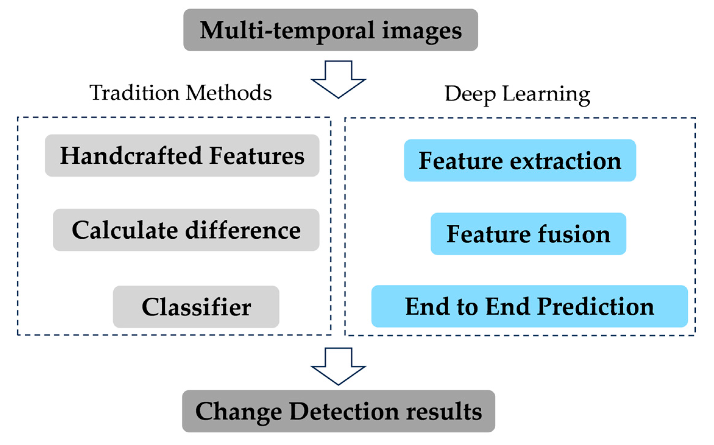
Although the aforementioned traditional methods achieved certain success in specific scenarios, their performance bottleneck is inherent in their heavy reliance on handcrafted features and prior knowledge, which fundamentally limits their generalization capability and adaptability to complex environments. To better illustrate the methodological evolution, we provide a comparative summary between traditional approaches and deep learning-based methods in Figure 1.
Concurrently, the rise of deep learning technology has brought about a shift in the field of computer vision. Deep CNNs possess [29] the ability to automatically learn highly discriminative hierarchical feature representations in an end-to-end manner, moving beyond manually designed rules. This characteristic makes them naturally suitable for the complex task of remote sensing image change detection: they can not only implicitly learn to distinguish ‘change’ from ‘no-change’ from massive data, but also effectively capture the complex interactions of spectral and spatial contextual information, thereby overcoming disturbances caused by illumination, seasonality, and other pseudo changes. Pioneering works, such as fully convolutional Siamese networks [7] was introduced into the change detection domain. By employing a shared weight, two-branch encoder to extract features from bitemporal images separately for subsequent difference comparison or fusion, they laid a solid foundation for data-driven change detection methods.
However, their core operation convolution relies on a fixed geometric structure and local receptive fields, which introduces two fundamental limitations: (1) difficulty in effectively modeling long-range dependencies, hindering the utilization of global contextual information for accurate change inference; and (2) weak adaptability to geometric transformations (e.g., rotation, deformation) of targets, which are prevalent in cultivated land changes. To overcome these limitations of CNNs, researchers began to explore the introduction of the Transformer [30,31] architecture into change detection tasks. The core of transformer the self-Attention mechanism can calculate interactions between any two positions in an image, thereby inherently possessing a global modeling capability. This allows the model to integrate contextual information from the entire image, significantly enhancing robustness to complex scenes and pseudo-changes (e.g., illumination, cloud shadows). Although Transformers excel at capturing global context, they also present certain challenges: their computational complexity grows quadratically with image size, demanding substantial computational resources. Furthermore, they lack the inductive biases inherent in CNNs, such as translation invariance and locality. When training data is limited, this can hinder their ability to capture fine-grained local details and edge features elements crucial for generating precise change boundaries. Recent research trends have favored hybrid models combining CNNs and Transformers [32,33], aiming to leverage the strengths of both architectures. However, how to efficiently fuse these two components while addressing specific issues such as multi-scale feature redundancy or detail preservation remains an open research question. To better highlight the shortcomings of existing methods and clarify the motivation of this work, we summarize the limitations of mainstream change detection approaches in Table 1.
To tackle this, we proposed an enhanced FPN that incorporates DCN and a DLRF module. This design leverages DCN to achieve adaptive feature alignment for capturing geometric deformations, and employs DLRF to realize efficient multi-scale feature compression and fusion. We name this network the Deformable Fusion and Grouped residual self-attention Network (DFGNet).

3. Methodology

3.1. Overall Framework of the Proposed Network

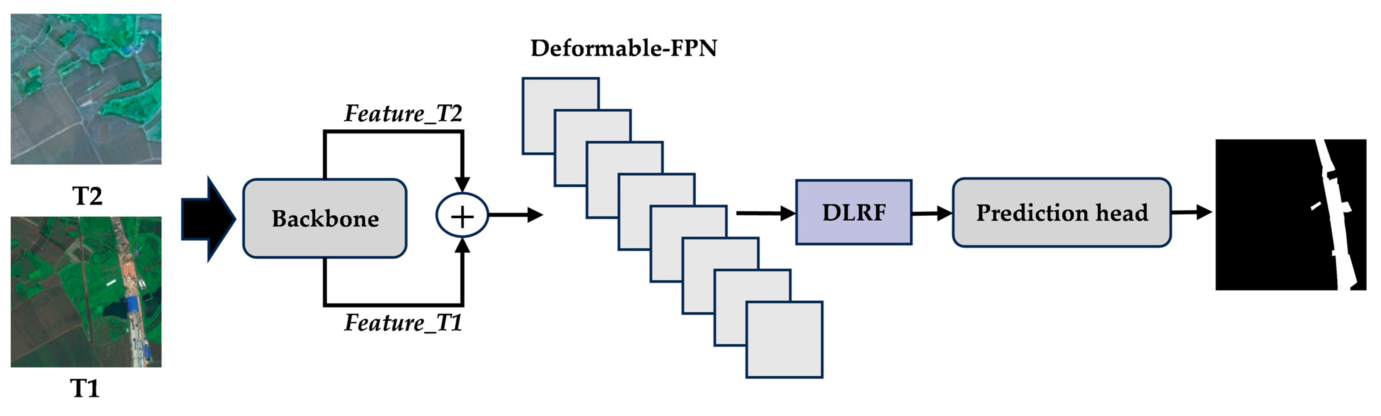
DFGNet overcomes the aforementioned limitations by leveraging the deformable FPN’s adaptive feature alignment capability to capture irregular multi-resolution information and the dynamic low-rank fusion’s matrix decomposition strategy to compress redundant parameters, thus outperforming prior methods in both accuracy and efficiency. Figure 2 illustrates the architecture of the proposed network, a dual encoder–decoder framework for accurate cropland change detection in bitemporal remote sensing images (T1: earlier, T2: later). Optimized for agricultural scenarios, it addresses key challenges such as fragmented changes, irregular boundaries, and pseudo-changes caused by illumination or phenology. The model inputs spatially aligned T1-T2 image pairs, where pre-alignment ensures consistent ground object positioning and avoids misalignment-induced false detections. The T1 and T2 images are concatenated along the channel dimension and processed as a single multi-channel input. A shared-weight encoder backbone (ResNet50) extracts multi-level features: low-level (C2) capturing fine details like textures and edges, mid-level (C3–C4) integrating local semantics (cropland vs. non-cropland), and high-level (C5) encoding global context for large-scale changes. These multi-level features feed into the Deformable Feature Pyramid Network (FPN). Standard FPN upsampling often introduces spatial misalignment due to element interpolation or repetition, especially when handling irregular cropland shapes. To address this, Deformable Convolutions (DCN) are applied in the upsampling path, learning adaptive spatial offsets to precisely align features across scales. Outputs at pyramid levels P2, P3, and P4 are then treated as query (Q), key (K), and value (V) within a Grouped Residual Self-Attention (GRSA) mechanism, enabling dynamic multi-scale feature interaction and emphasizing discriminative change regions. The Dynamic Low-Rank Fusion (DLRF) module further refines the fused features. Instead of directly fusing high-dimensional feature maps, DLRF factorizes the feature matrix into two smaller matrices, reducing redundancy while retaining essential information. Attention weights from GRSA are applied to highlight critical change signals across scales, ensuring accurate detection of fragmented changes and preserving boundary precision. Compared with traditional low-rank fusion methods, DLRF adjusts to the content of the input features, providing more flexible and discriminative feature integration.

3.2. Deformable FPN

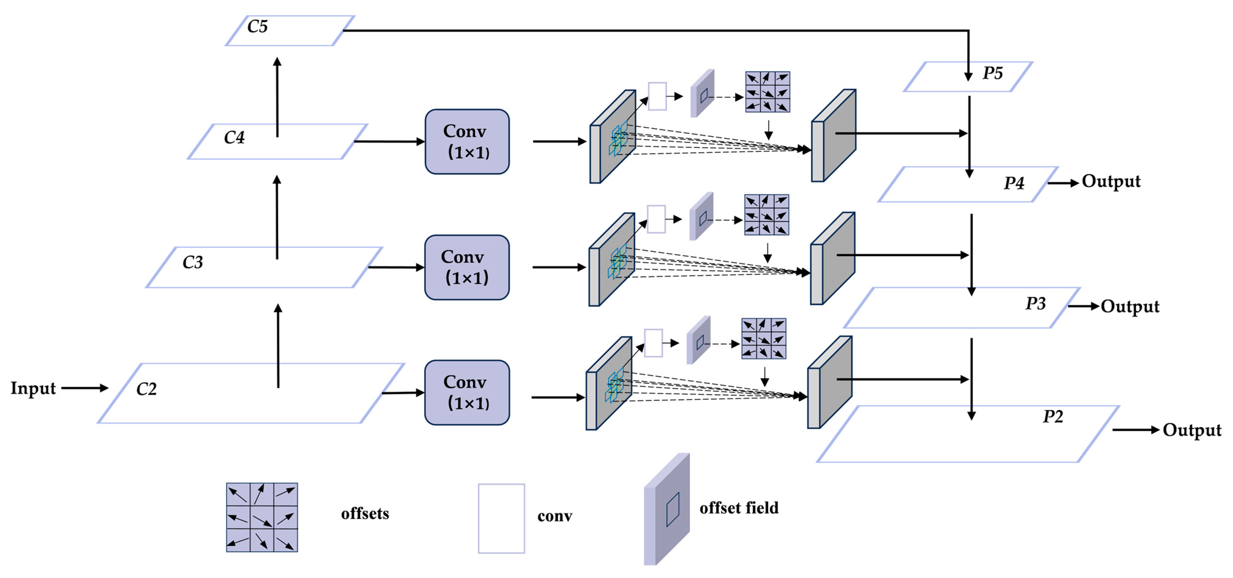
The Feature Pyramid Network (FPN) constructs a feature pyramid for multi-scale object detection through top-down paths and lateral connections. However, due to its fixed sampling grid, the standard convolution operation in FPN is insufficient when dealing with irregular shapes and slight misalignments that are common in cultivated land change detection. To address this limitation, we propose the Deformable FPN, which replaces all standard convolutions in its upsampling path with Deformable Convolutions (DCN). As shown in Figure 3, the Deformable FPN constructs a multi-scale feature pyramid by fusing features from the encoder and the top-down pathway. It takes the encoder’s multi-level feature maps {C2, C3, C4, C5} as inputs and generates the enhanced, fused feature maps {P2, P3, P4, P5} as outputs. It first undergoes a 1 × 1 convolutional layer for channel reduction and linear projection, preparing the feature for subsequent processing. The projected feature is then fed into the core Deformable Convolutional layer (DCL). Instead of using a fixed sampling grid, the DCN layer learns a set of offset fields from the input feature itself through an auxiliary convolutional layer. This allows the convolutional kernel to adaptively adjust its sampling locations to the geometric structures of the cultivated land boundaries, significantly enhancing its ability to model irregular shapes. The process can be formulated as:
y ( p 0 ) = k = 1 K w ( p k ) x ( p 0 + p k + p k ) ,
where p 0 represents the target location on the output feature map y where the convolution operation is currently being applied. w ( p k ) is the weight parameter of the convolution kernel at the position p k ,which enumerates the locations in the conventional sampling grid and Δ p k is the learned offset, It is automatically learned from the features of the previous layer through an additional convolutional layer, enabling the model to adaptively adjust the sampling positions to focus on the key regions of the target. x is the input feature map value at the fixed sampling location. The geometrically augmented feature from the DCN layer is then fused with the upsampling feature from a higher pyramid level via element-wise addition. The result of this fusion is the output feature map for the current level, which carries both rich semantic context from the top-down path and enhanced detailed, deformation-aware features from the bottom-up path.

3.3. Dynamic Low-Rank Fusion

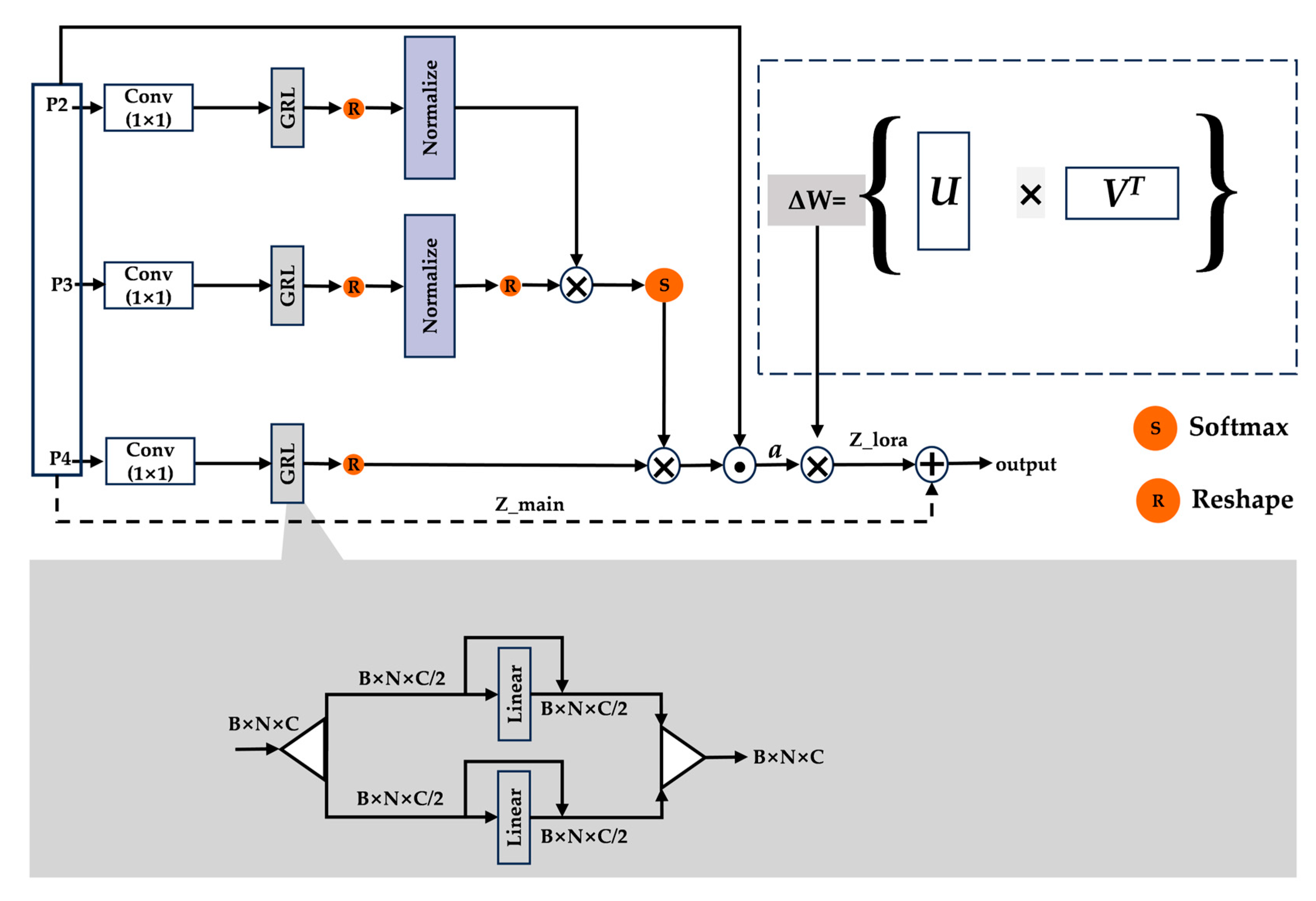
To effectively fuse the multi-scale features generated by the Deformable FPN and suppress redundant information, DLRF was designed as shown in Figure 4. First, since the input multi-scale features {P2, P3, P4} are inconsistent in both channel dimension and spatial scale, this module uses independent 1 × 1 convolutional layers to project features of each scale. This operation aims to achieve three purposes: (1) unifying the number of channels to a preset dimension C to meet the dimensional requirements of subsequent calculations; (2) performing a basic linear transformation on the original features to map them to a feature space more suitable for fusion; (3) reducing the computational complexity to a certain extent. The projected features are fed into the Grouped Residual Self-Attention (GRSA) module to generate dynamic weights [34]. It is worth noting that features of different scales are used as sources for Query (Q), Key (K), and Value (V), respectively (P2 as Q, P3 as K, P4 as V) [35], thereby realizing a cross-scale feature interaction and attention calculation mechanism.
This module ultimately outputs a dynamic weight vector α with dimension C. The dynamic weight vector α is then used to perform channel-wise modulation on the projected features, resulting in calibrated features denoted as:
X * = α Δ W ,
This operation enhances the signals of important channels and suppresses redundant ones. The modulated features X * are fed into the low-rank decomposition branch for fusion. This branch computes its output using the formula:
Z l o r a = U V T X * ,
where U and V T are two learnable low-rank matrices, and their product U V T approximates a complete fusion weight matrix Δ W . Finally, the output Z l o r a of the low-rank branch and the output Z m a i n of the main branch are fused via residual connection, yielding the final output of the module:
Z f u s e d = Z l o r a + Z m a i n ,
Through the above process, the Dynamic Low-Rank Fusion module not only achieves efficient fusion of multi-scale features, but also endows the model with the ability to dynamically adapt to input content and suppress redundancy via its inherent attention and low-rank mechanisms [22,23]. This provides a more discriminative feature representation for subsequent change detection tasks.

Computational Complexity Analysis

The core of the DLRF module is the low-rank approximation and reconstruction X = U V T This design is crucial for managing computational cost, especially given our high-resolution input imagery. The complexity of the X = U V T operation is O ( m n r ) , where m = H × W is the spatial dimension, n is the channel dimension, and is the r n low rank. In our experimental setup with H = W = 512   n = 1024 , and r = 32 , this operation requires approximately 17.2 GFLOPs. In contrast, a fully connected fusion layer applied to the same feature matrix would have a complexity of O ( m n 2 ) , amounting to roughly 550 TFLOPs—an infeasible cost that is over 31,000 times greater. Thus, our DLRF module makes efficient, high-resolution feature integration computationally tractable.

3.4. Explainable AI (XAI)-Based Interpretation of DFGNet

The “black-box nature” of deep learning models may raise doubts about their decision-making rationality. To address this concern, it is necessary to uncover the model’s attention mechanism through Explainable Artificial Intelligence (XAI) techniques. Among mainstream XAI methods, Gradient-weighted Class Activation Mapping (Grad-CAM) [36] is widely adopted for interpreting network behavior in visual tasks, as it directly links the spatial regions of remote sensing images to model predictions—making it particularly suitable for cropland change detection.

4. Experiments

4.1. Dataset

To comprehensively validate the performance of DFGNet in cropland change detection, this study adopts a two-dataset design: the CLCD dataset (acquired by Gaofen-2) [37] is used for the binary classification task, while the Jilin-1 high-resolution dataset is employed for the qualitative visualization extension of the multi-class classification task. Details of the two satellites are provided in Appendix A.

4.2. Experimental Settings and Configuration

The experimental settings and other configuration for this study is shown in Table 2.

4.3. Evaluation Metrics

Four common metrics, precision (Pre), recall (Rec), F1-score and mean intersection over union (mIoU), are selected for accuracy assessment. They can be defined as follows:
Pre = TP TP + FP ,
Rec = TP TP + FN ,
F 1 = 2 Pre × Rec Pre + Rec ,
mIoU = 1 N ( TP FP + TP + FN ) ,
where TP, TN, FP, FN and N represent true positives, true negatives, false positives, false negatives, and num of classes, respectively.

4.4. Comparative Experiments

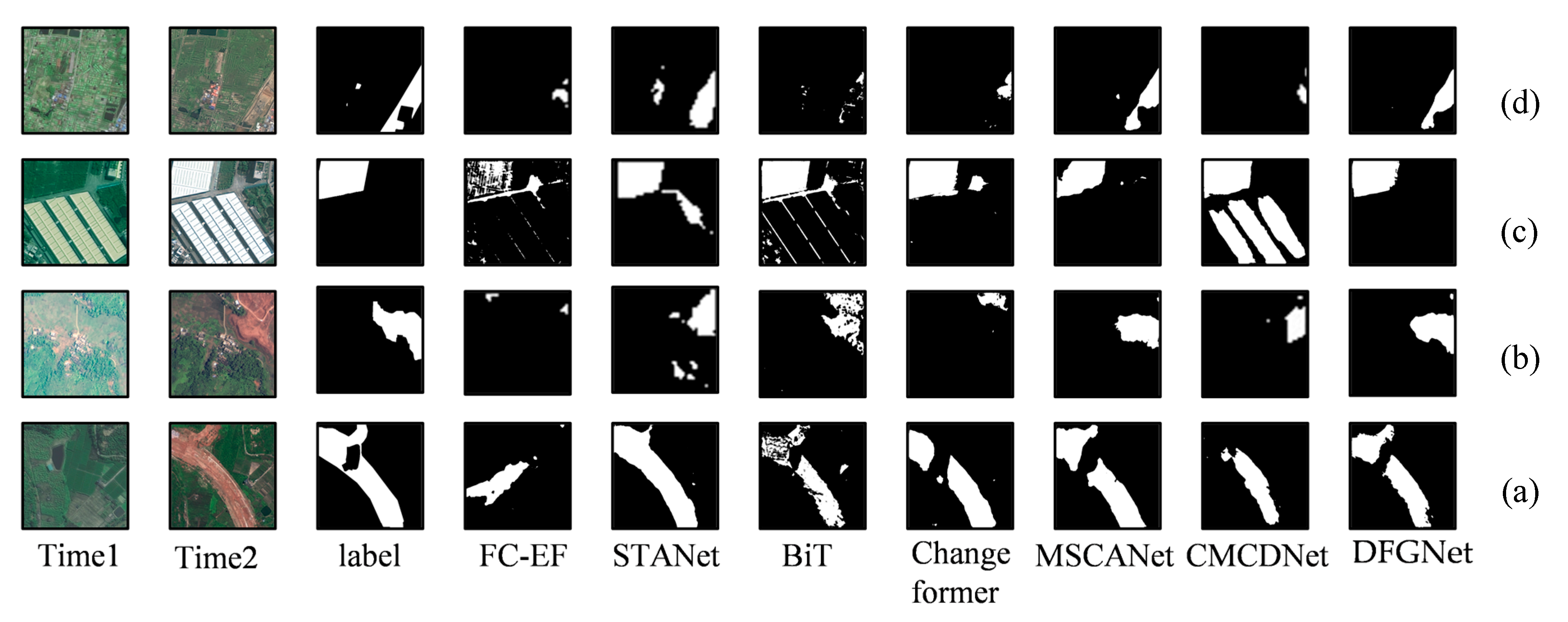
To comprehensively evaluate the effectiveness of the method proposed in this study, we conducted quantitative and qualitative comparisons between it and various advanced change detection models on the Crop Land-Change Detection dataset. The selected comparison baselines include: (1) FC-EF [7] is an UNet-based change detection method, which receives concatenation of bitemporal images as input, regarding them as separate channels. (2) STANet [38]: a new spatiotemporal attention neural network based on the Siamese network architecture. It leverages spatiotemporal dependencies and incorporates a change detection self-attention module into feature extraction to generate more discriminative features. (3) ChangeFormer [39]: A network that combines a hierarchical Transformer encoder and an MLP decoder within a Siamese network structure, enabling efficient extraction of multi-scale long-range details required for accurate Change Detection. (4) BiT [12] is a transformer-based feature fusion method, which integrates Siamese tokenizer and transformers encoder–decoder structure into the common Change Detection network, thus performing capably to capture more meaningful and effective contextual concepts in global feature space. (5) MSCANet [37]: a CNN-transformer network with multiscale context aggregation. (6) CMCDNet [40]: A network that adopts an encoder–decoder structure and performs feature fusion at multiple stages through gating and self-attention modules. Quantitative results of all methods on CLCD are given in Table 3.
In terms of the mean Intersection over Union (mIoU) metric, the proposed method outperforms other approaches with a score of 57.57%, which is approximately 4 percentage points higher than that of MSCANet (53.55%). In contrast, CMCDNet (50.71%) and Changeformer (52.61%) perform relatively weakly, remaining only at a moderate level. This indicates that the proposed method exhibits better global consistency and spatial alignment in terms of the coverage of overall changed areas. In terms of the F1-score, the proposed method achieves 72.42%, which is higher than that of MSCANet (69.75%), STANet (58.13%), and Changeformer (51.43%). This demonstrates that DFGNet achieves a better balance between detection accuracy and coverage comprehensiveness, enhancing overall detection performance. As shown in Figure 5, the ChangeFormer model, due to its over-reliance on global modeling, achieves a Recall of only 60.61%, which is significantly lower than DFGNet’s 71.41%—validating the effectiveness of the locally refined module designed in this study in reducing the missed detection rate. While MSCANet, CMCDNet, and ChangeFormer have achieved modest improvements in some metrics, their overall performance still lags behind DFGNet, particularly exhibiting gaps in mIoU and F1-score. Visualization comparison on CLCD is shown in Figure 5.
It can be clearly seen from the results in Figure 5a that CMCDNet has a certain capability in local area detection, but there are obvious issues of edge breakage and regional incoherence. Some changed pixels fail to be fully covered, showing a certain degree of missed detection. ChangeFormer can identify the approximate outline of changed areas, yet obvious artifacts and false detection noise appear at the edges, with blurred boundaries and poor stability. MSCANet introduces multi-scale feature aggregation to enhance feature expression ability, but there are still phenomena of detail loss and small area omission, and some edges present a jagged shape. For the FC-EF exhibits missed detection in detection. When facing areas with complex textures and high noise, its detection accuracy is limited. BiT and STANet have reduced the area of missed detection regions.

4.5. Ablation Studies

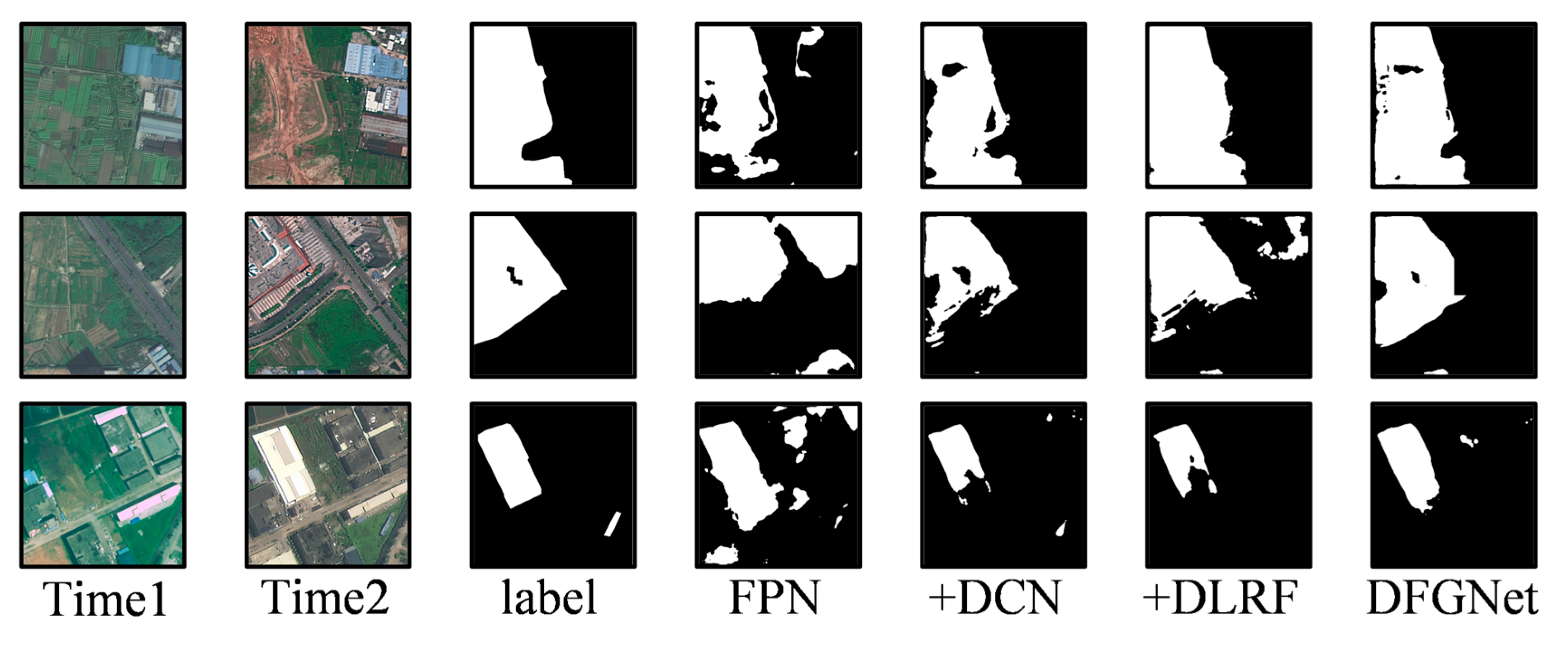
To verify the contribution of each module proposed in this study to the overall performance, we gradually introduced Deformable Convolutional Networks (DCN), low-rank feature fusion, and grouped residual attention into the FPN framework, and conducted combined ablation experiments, respectively. The experimental results are presented in Table 4.
In terms of the Mean Intersection over Union (mIoU) metric, the baseline FPN model achieves a score of 53.55%. After integrating the Deformable Convolutional Network (DCN), the mIoU increases to 55.84%, a rise of approximately 2.3 percentage points. This indicates that DCN can effectively compensate for the offset caused by the upsampling process and enhance the consistency of spatial features. When the Deformable Low-Rank Feature Fusion (DLRF) module is introduced, the mIoU further rises to 56.42%, which is higher than that of the model with only DCN incorporated. Figure 6 shows a visual comparison of the ablation experiments. Each module (DCN, DLRF) improves boundary delineation and subtle change detection, while the combined model (DFGNet) produces the most accurate and coherent predictions, confirming their synergistic effect.

4.6. Analysis of Global Attention in Model from the Perspective of Grad-CAM

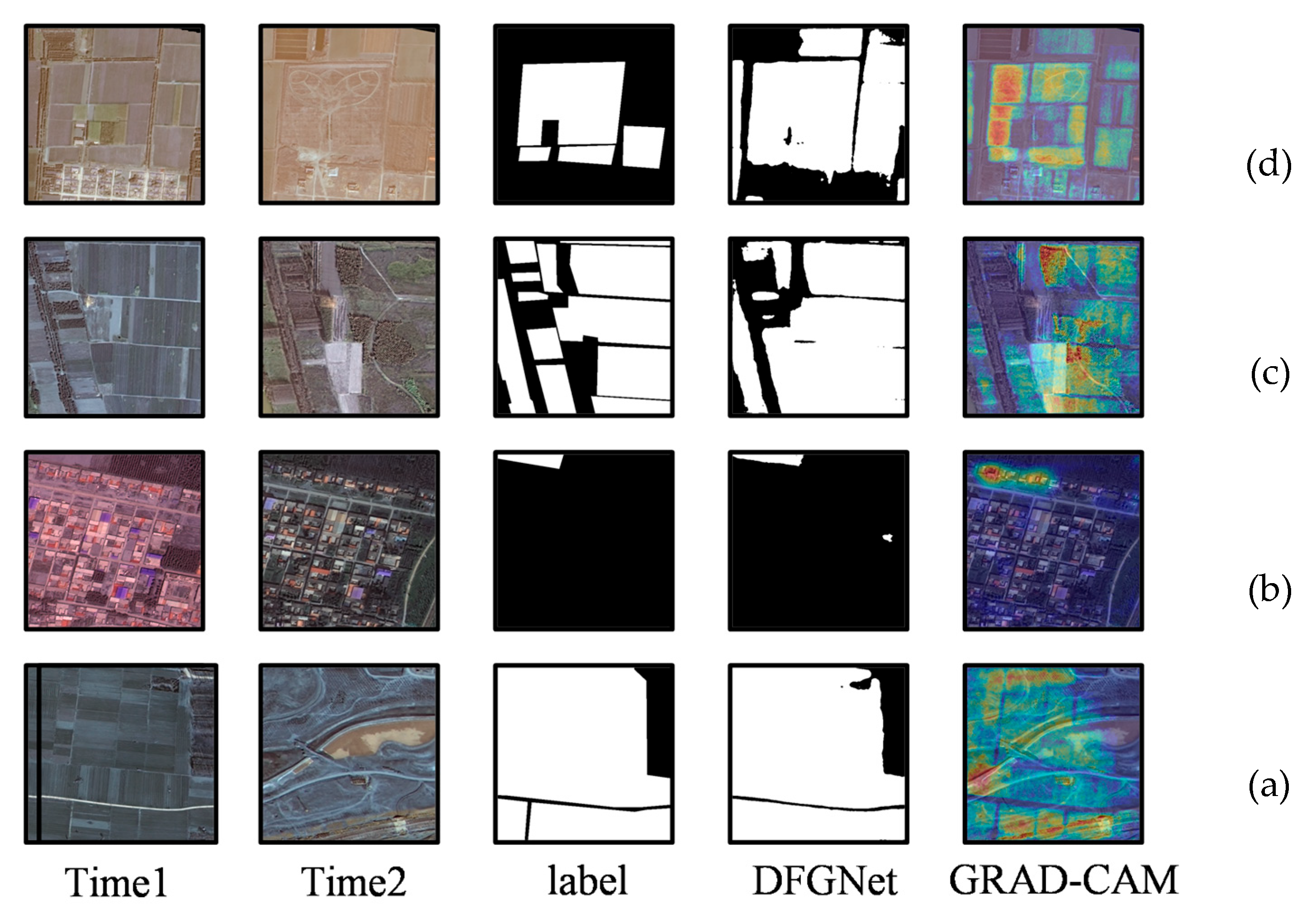
To explore the decision-making mechanism of DFGNet and address the interpretability concerns arising from the “black-box nature” of deep learning models, this section will adopt the Gradient-weighted Class Activation Mapping (Grad-CAM) method to conduct a systematic visualization analysis of the global attention distribution characteristics of DFGNet in the cropland change detection task. Through this visualization approach, we aim to verify whether the model can proactively focus on the “core regions critical for change type identification and change boundary localization” in cropland change detection, rather than indiscriminately focusing on irrelevant background information. On this basis, we intuitively demonstrate the scientificity, interpretability, and logical consistency of DFGNet’s decision-making process, effectively alleviating potential doubts about the model’s “black-box decision-making.” Visualization results are presented in Figure 7.
The results of Figure 7a,b show that the high-attention coverage areas of the heatmap are highly consistent with the core areas of the crop land change labels. Observation of the prediction results in Figure 7c reveals that the model exhibits false detection in the lower-middle part of the image—it misclassifies crop land areas that are actually non-change areas as change areas. However, the heatmap at the corresponding positions consistently shows low-attention characteristics, which aligns with the fact that “this area has no actual changes” and intuitively reflects the rationality of the model’s attention distribution. Additionally, the overall comparison results of Figure 7d indicate that the high-attention areas of the heatmap have covered most of the change areas marked by the labels, with only minor omissions in small edge regions. This further verifies the spatial consistency between the heatmap and the actual crop land change features.
From the comparison of heatmaps, label, and model prediction results in Figure 7, it can be seen that the attention regions of the model’s heatmaps overlap with the core regions of the ground truth labels for crop land changes. This indicates that the model achieves high-precision localization in the crop land change detection task.

4.7. Generalization Evaluation on the Jilin-1 Dataset

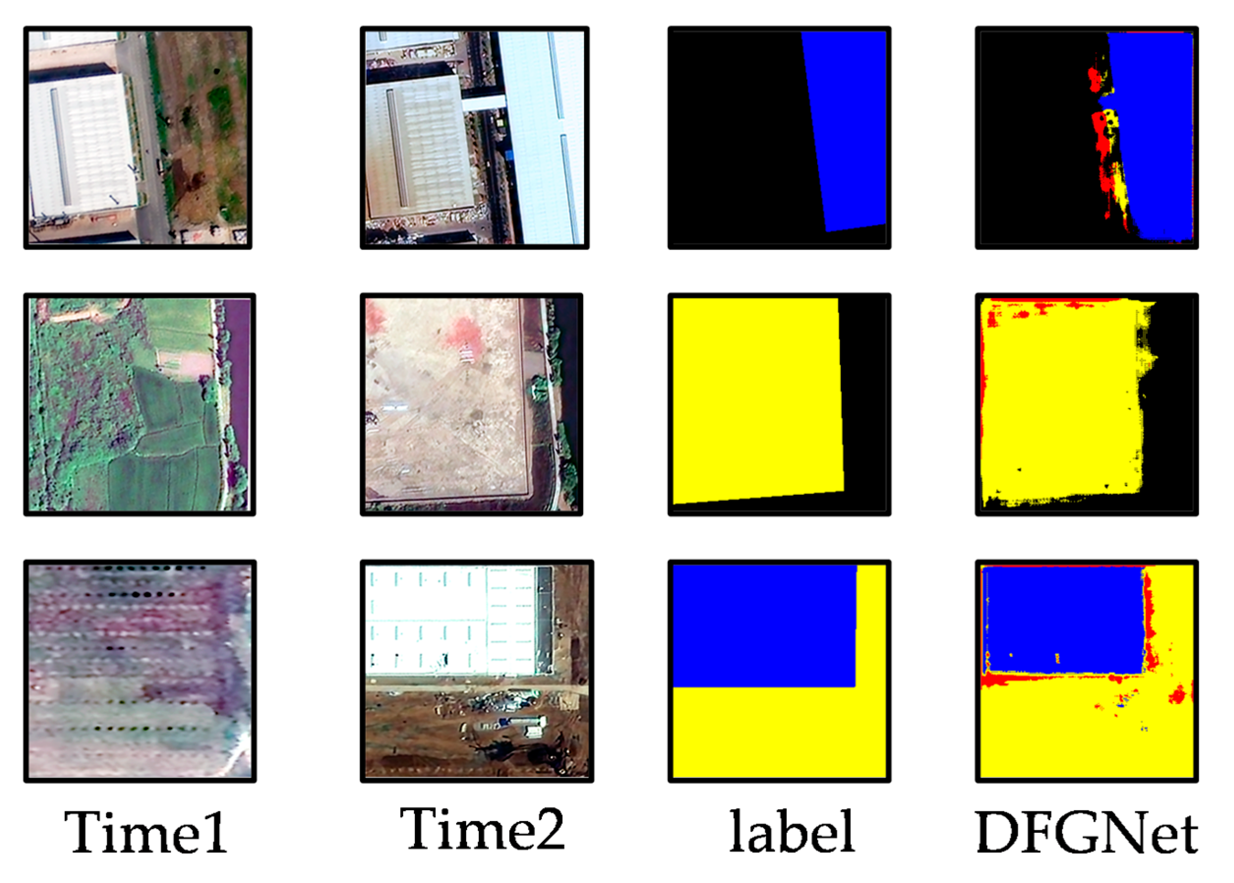
To verify the generalization ability of the model, we conducted multiclass cropland change detection experiments on the Jilin-1 dataset [41] and supplemented comprehensive quantitative evaluation results. For the multi-class task, we adopted core evaluation metrics: mean Intersection over Union (mIoU), Recall, Precision, and F1-score. The quantitative results are summarized as follows: the model achieves an overall mIoU of 81.5%, with Recall/Precision/F1-score of (77.2%, 79.5%, 78.3%). From Figure 8 it can be observed that the model classifies most regions in the multiclass task, though some misclassifications exist. The visualization results are shown in Figure 8. (The RGB color coding and its corresponding cropland change types are defined as follows: Black represents the background category, referring to areas with no cropland change. Red denotes the conversion of cropland to road areas. Blue stands for the conversion of cropland to construction land. Yellow represents the conversion of cropland to other land use types.)

5. Discussion

The performance of cropland change detection largely depends on a model’s ability to capture both global contextual information and fine-grained local features. In this study, we propose a new network (DFGNet) that integrates Deformable Convolutional Network (DCN), Deformable Low-Rank Feature Fusion (DLRF), and Grouped Residual Self-Attention (GRSA) modules. Each module plays a unique role in enhancing feature representation and fusion.
Existing related studies have limitations in interpretability and stability: For interpretability, although methods like SAM-UNet [42] emphasize the need for “change detection techniques with strong interpretability”, they lack a clear spatial attribution method to trace the model’s decision-making paths. For stability, traditional improved Change Vector Analysis (CVA) [43] methods are still sensitive to noise and “pseudo-changes,” struggling to adapt to complex radiometric differences in cropland monitoring.
In contrast, DFGNet makes up for these shortcomings: The GRSA module combined with Grad-CAM visualization can intuitively explain the attention distribution of change regions, solving the problem that existing methods lack a clear way to trace decision-making paths. Meanwhile, the DCN and DLRF modules work together to reduce the model’s sensitivity to radiometric noise, overcoming the stability defects of traditional methods when dealing with pseudo-changes.

6. Conclusions

This study proposes a differentiated solution based on DFGNet, distinguishing itself from existing research: (1) The Deformable Convolutional Network (DCN) module accurately captures fine-grained change details by adaptively adjusting receptive fields, addressing the issue of inaccurate boundary localization; (2) the Deformable Low-Rank Feature Fusion (DLRF) module improves model efficiency by reducing model parameters.
Experimental results demonstrate that DFGNet outperforms comparative models in key metrics (mean Intersection over Union (mIoU): 57.57%, F1-score: 72.42%), significantly enhancing the accuracy and reliability of cropland identification and change detection.
Future work will focus on two practical extension directions: (1) model lightweighting design, leveraging techniques such as pruning, quantization, or knowledge distillation [44] to reduce model size and computational complexity, enabling efficient deployment on edge computing devices; (2) enhancing cross-regional generalization ability, through domain-adaptive learning [45] and scenario-specific data augmentation strategies, to improve the model’s adaptability to remote sensing data under different climate zones, imaging conditions, and farming practices. Ultimately, this will lay a technical foundation for constructing a high-precision and real-time intelligent agricultural remote sensing interpretation platform.

Author Contributions

Conceptualization, X.F. and X.L.; methodology, X.F.; data curation, X.F.; writing—original draft, X.F.; writing—review and editing, X.F. All authors have read and agreed to the published version of the manuscript.

Funding

This work is supported in part by the Special Fund for Training High Level Innovative Talents of Sichuan University of Science and Engineering, under Grant B12402005, and in part the National Natural Science Foundation of China under Grant 42471437.

Data Availability Statement

The data related to this study can be obtained by contacting the first author.

Conflicts of Interest

The authors declare that they have no known competing financial interests or personal relationships that could have appeared to influence the work reported in this paper.

Appendix A

Appendix A.1. GF-2 Satellite and CLCD Dataset Details

Reproductivity:
Description of GF-2 Sensor Characteristics and Preprocessing Workflow.
The GF-2 image data used in this study is sourced from the public dataset [36]. The relevant sensor characteristics are as follows:
Core Sensor Characteristics;
Spatial resolution: 1 m (panchromatic band), 4 m (multispectral bands);
Temporal resolution: 5-day revisit period (under cloud-free and snow-free conditions);
Spectral resolution: Covers 4 bands, including the blue band (450–520 nm), green band (520–590 nm), red band (630–690 nm), and near-infrared (NIR) band (770–890 nm);
Radiometric resolution: 12-bit (dynamic range: 0–4095), with a quantization depth sufficient for fine-grained cropland change detection.
Given that the preprocessing workflow of the original dataset has been fully validated for reliability, we directly used the final preprocessed data for experiments to avoid introducing additional noise from redundant processing. The revised manuscript includes citations to the original dataset’s literature and links to official documentation for reviewers and other researchers to verify.
(1)
Feasibility and Conditions for Replicating Experiments with Other Optical Sensors
The proposed DFGNet model is a data-driven architecture that does not rely on specific sensors. Experiments can be replicated using globally accessible optical sensors such as Sentinel-2 and Landsat-8/9, provided the input data meets the following core conditions:
Spatial resolution ≥ 10 m: To effectively capture fine-grained change features such as cropland parcel boundaries and field ridges;
Spectral band requirements: At least include the red band (630–690 nm) and NIR band (770–890 nm) to distinguish core information such as cropland vs. non-cropland and changes in vegetation growth status;
Data preprocessing requirements: Standardized radiometric and atmospheric corrections are performed to reduce radiometric differences caused by varying imaging conditions (e.g., illumination, atmospheric status).
(2)
Data Public Availability, Licensing, and Replication Steps
Data Public Availability and Licensing CLCD dataset:
(link: https://github.com/liumency/CropLand-CD accessed on 13 June 2025)
Experiment Replication Steps for Researchers Outside China Other researchers (including those outside China) can fully replicate the experiment by following these steps:
(1) Data acquisition: Download the CLCD dataset’s annotation files and corresponding preprocessed GF-2 images (or select Sentinel-2/Landsat-8/9 data that meets the replication conditions) via the aforementioned public channels; (2) Data adaptation (if using non-GF-2 data): Perform preprocessing (radiometric correction, atmospheric correction, registration/super-resolution) on Sentinel-2/Landsat-8/9 data in accordance with the conditions outlined above to ensure data quality consistency with this study; (3) Model configuration: Configure the DFGNet model using the parameters described in the Experimental Setup section of the revised manuscript (batch size = 2, learning rate = 1 × 10⁻⁴, training epochs = 100, optimizer = Adam); (4) Experimental validation: Conduct training and testing using the processed dataset with the same evaluation metrics (mIoU, F1-score, Recall, Precision) and evaluation method (5-fold cross-validation) as in this study to replicate the experimental results.

Appendix A.2. Jilin-1 Satellite Dataset Details

Reproductivity:
Description of Jilin-1 Sensor Characteristics and Preprocessing Workflow.
Core Sensor Characteristics (Based on Public General Information from the Official Website) Combining the general parameters of the Jilin-1 optical satellite series disclosed on Changguang Satellite’s official website and the basic information labeled in the dataset, we have compiled and supplemented the range of core characteristics (applicable to most optical sub-series):
Spatial resolution: 0.75 m (panchromatic band), 3 m (multispectral bands).
Spectral resolution: Covers 4 core bands (blue, green, red, and near-infrared) (a universal configuration on the official website, with a spectral range highly compatible with mainstream optical sensors such as Gaofen-2 and Sentinel-2);
Preprocessing Workflow (Based on Official Standardized Preprocessed Data) It is emphasized that this study directly used the standardized preprocessed data provided by the official website, without performing any additional preprocessing operations.
(1)
Feasibility of Replicating Experiments with Globally Accessible High-Resolution Data Sources
The proposed DFGNet model is designed to be independent of specific sensors or datasets. Experiments can be fully replicated using globally accessible high-resolution data sources such as Google Earth, ESRI World Imagery, and Sentinel-2. The specific conditions and steps are as follows (supplemented in the Experimental Validation section of the revised manuscript):
Core Reproduction Conditions:
Spatial resolution ≥ 10 m (Sentinel-2 and other 10 m level data can be used directly; for sub-meter data such as Google Earth, resampling to 10 m can unify the resolution without affecting model performance);
Multi-temporal image requirements: Two or more images of the same study area with consistent seasonal timing (e.g., images from the same season within two years) to ensure the detectability of cropland change signals;
Spectral requirements: At least include two core bands (red and near-infrared) (satisfied by all mainstream optical data sources);
Preprocessing requirements: Complete standardized radiometric correction, atmospheric correction, and geometric registration (registration error ≤ 1 pixel). The data can be official preprocessed products (e.g., Sentinel-2 Level-2A) or self-processed data meeting the above standards.
Reason for Not Conducting Direct Validation with Such Data Sources. This study focuses on verifying model architecture innovation. The Jilin-1 dataset was selected due to its research-grade annotation quality (endorsed by the official website) and compatibility with the cropland scenarios in the study area. As the core goal is to validate the model’s effectiveness, and considering that the official preprocessed data of Jilin-1 has passed quality verification, direct validation with other data sources was not performed to avoid redundant work (the core validation logic is consistent across datasets). Future research will supplement cross-data-source comparative validation to further enhance the model’s generality.
(2)
Universal Experimental Reproduction Steps (Global Applicability)
To facilitate reproduction by researchers worldwide, we have supplemented general steps based on any high-resolution optical data source:
Data acquisition: Download multi-temporal optical images of the target area (official preprocessed products are preferred to ensure consistency; self-processed data must meet the above reproduction conditions);
Data adaptation (if using self-processed data): Perform processing in the workflow of radiometric correction → atmospheric correction → geometric registration → resolution unification (if needed) to ensure a registration error ≤ 1 pixel;
Annotation construction: Refer to the cropland change annotation specifications of the CLCD dataset (annotation instructions available for download on the official website) to label change regions (cropland → non-cropland, non-cropland → cropland);
Model configuration: Configure DFGNet according to the parameters in the Experimental Setup section of the revised manuscript (batch size = 8, learning rate = 1 × 10⁻⁴, training epochs = 100, optimizer = Adam);
Validation and evaluation: Use unified metrics such as mIoU, F1-score, and Recall, and perform 5-fold cross-validation to replicate the experimental results.

References

  1. Varzakas, T.; Smaoui, S. Global Food Security and Sustainability Issues: The Road to 2030 from Nutrition and Sustainable Healthy Diets to Food Systems Change. Foods 2024, 13, 306. [Google Scholar] [CrossRef]
  2. Saidi, S.; Idbraim, S.; Karmoude, Y.; Masse, A.; Arbelo, M. Deep-Learning for Change Detection Using Multi-Modal Fusion of Remote Sensing Images: A Review. Remote Sens. 2024, 16, 3852. [Google Scholar] [CrossRef]
  3. Dalla Mura, M.; Prasad, S.; Pacifici, F.; Gamba, P.; Chanussot, J.; Benediktsson, J.A. Challenges and Opportunities of Multimodality and Data Fusion in Remote Sensing. Proc. IEEE 2015, 103, 1585–1601. [Google Scholar] [CrossRef]
  4. Peng, D.; Liu, X.; Zhang, Y.; Guan, H.; Li, Y.; Bruzzone, L. Deep Learning Change Detection Techniques for Optical Remote Sensing Imagery: Status, Perspectives and Challenges. Int. J. Appl. Earth Obs. Geoinf. 2025, 136, 104282. [Google Scholar] [CrossRef]
  5. Shafique, A.; Cao, G.; Khan, Z.; Asad, M.; Aslam, M. Deep Learning-Based Change Detection in Remote Sensing Images: A Review. Remote Sens. 2022, 14, 871. [Google Scholar] [CrossRef]
  6. Liu, X.; Zhou, Y.; Zhao, J.; Yao, R.; Liu, B.; Zheng, Y. Siamese convolutional neural networks for remote sensing scene classification. IEEE Geosci. Remote Sens. Lett. 2019, 16, 1200–1204. [Google Scholar] [CrossRef]
  7. Daudt, R.C.; Le Saux, B.; Boulch, A. Fully convolutional siamese networks for change detection. In Proceedings of the 2018 25th IEEE International Conference on Image Processing (ICIP), Athens, Greece, 7–10 October 2018; pp. 4063–4067. [Google Scholar] [CrossRef]
  8. Parmar, N.; Vaswani, A.; Uszkoreit, J.; Kaiser, L.; Shazeer, N.; Ku, A.; Tran, D. Image transformer. In Proceedings of the International Conference on Machine Learning; Stockholmsmassan, Stockholm, Sweden, 10–15 July 2018; pp. 4055–4064. [Google Scholar]
  9. Kitaev, N.; Kaiser, L.; Levskaya, A. Reformer: The efficient transformer. arXiv 2020, arXiv:2001.04451. [Google Scholar] [CrossRef]
  10. Yao, D.; Shao, Y. A data efficient transformer based on Swin Transformer. Vis. Comput. 2024, 40, 2589–2598. [Google Scholar] [CrossRef]
  11. Ferdous, G.J.; Sathi, K.A.; Hossain, M.A.; Hoque, M.M.; Dewan, M.A.A. LCDEiT: A linear complexity data-efficient image transformer for MRI brain tumor classification. IEEE Access 2023, 11, 20337–20350. [Google Scholar] [CrossRef]
  12. Chen, H.; Qi, Z.; Shi, Z. Remote sensing image change detection with transformers. IEEE Trans. Geoscience. Remote Sens. 2021, 60, 1–14. [Google Scholar] [CrossRef]
  13. Huo, X.; Sun, G.; Tian, S.; Wang, Y.; Yu, L.; Long, J.; Zhang, W.; Li, A. HiFuse: Hierarchical multi-scale feature fusion network for medical image classification. Biomed. Signal Process. Control. 2024, 87, 105534. [Google Scholar] [CrossRef]
  14. Wang, G.; Gan, X.; Cao, Q.; Zhai, Q. MFANet: Multi-scale feature fusion network with attention mechanism. Vis. Comput. 2023, 39, 2969–2980. [Google Scholar] [CrossRef]
  15. Tu, Y.; Wu, S.; Chen, B.; Weng, Q.; Bai, Y.; Yang, J.; Yu, L.; Xu, B. A 30 m annual cropland dataset of China from 1986 to 2021. Earth Syst. Sci. Data 2024, 16, 2297–2316. [Google Scholar] [CrossRef]
  16. Huang, Z.; Yang, X.; Liu, Y.; Wang, Z.; Ma, Y.; Jing, H.; Liu, X. Multi-Type Change Detection and Distinction of Cultivated Land Parcels in High-Resolution Remote Sensing Images Based on Segment Anything Model. Remote Sens. 2025, 17, 787. [Google Scholar] [CrossRef]
  17. Xie, Y.; Spawn-Lee, S.A.; Radeloff, V.C.; Yin, H.; Robertson, G.P.; Lark, T.J. Cropland Abandonment Between 1986 and 2018 Across the United States: Spatiotemporal Patterns and Current Land Uses. Environ. Res. Lett. 2024, 19, 044009. [Google Scholar] [CrossRef]
  18. Tufail, R.; Tassinari, P.; Torreggiani, D. Deep Learning Applications for Crop Mapping Using Multi-Temporal Sentinel-2 Data and Red-Edge Vegetation Indices: Integrating Convolutional and Recurrent Neural Networks. Remote Sens. 2025, 17, 3207. [Google Scholar] [CrossRef]
  19. Lin, T.-Y.; Dollar, P.; Girshick, R.; He, K.; Hariharan, B.; Belongie, S. Feature pyramid networks for object detection. In Proceedings of the IEEE Conference on Computer Vision and Pattern Recognition, Honolulu, HI, USA, 21–26 July 2017; pp. 2117–2125. [Google Scholar] [CrossRef]
  20. Dai, J.; Qi, H.; Xiong, Y.; Li, Y.; Zhang, G.; Hu, H.; Wei, Y. Deformable convolutional networks. In Proceedings of the IEEE International Conference on Computer Vision, Venice, Italy, 22–29 October 2017; pp. 764–773. [Google Scholar] [CrossRef]
  21. Li, Y.; Deng, Z.; Cao, Y.; Liu, L. GRFormer: Grouped residual self-attention for lightweight single image super-resolution. In Proceedings of the 32nd ACM International Conference on Multimedia, Melbourne, Australia, 28 October–1 November 2024; pp. 9378–9386. [Google Scholar] [CrossRef]
  22. Huang, W.; Zhang, Y.; Zheng, X.; Liu, Y.; Lin, J.; Yao, Y.; Ji, R. Dynamic low-rank sparse adaptation for large language models. arXiv 2025, arXiv:2502.14816. [Google Scholar] [CrossRef]
  23. Valipour, M.; Rezagholizadeh, M.; Kobyzev, I.; Ghodsi, A. DyLoRA: Parameter-Efficient Tuning of Pre-Trained Models Using Dynamic Search-Free Low-Rank Adaptation. In Proceedings of the 17th Conference of the European Chapter of the Association for Computational Linguistics, Dubrovnik, Croatia, 2–6 May 2023; pp. 3274–3287. [Google Scholar] [CrossRef]
  24. Liu, J.; Fan, X.; Jiang, J.; Liu, R.; Luo, Z. Learning a deep multi-scale feature ensemble and an edge-attention guidance for image fusion. IEEE Trans. Circuits Syst. Video Technol. 2021, 32, 105–119. [Google Scholar] [CrossRef]
  25. Lu, D.; Mausel, P.; Brondizio, E.; Moran, E. Change detection techniques. Int. J. Remote Sens. 2004, 25, 2365–2401. [Google Scholar] [CrossRef]
  26. Shivakumar, B.R. Change detection using image differencing: A study over area surrounding Kumta, India. In Proceedings of the 2017 Second International Conference on Electrical, Computer and Communication Technologies (ICECCT), Coimbatore, India, 22–24 February 2017; pp. 1–5. [Google Scholar] [CrossRef]
  27. Talukdar, S.; Singha, P.; Mahato, S.; Pal, S.; Liou, Y.-A.; Rahman, A. Land-use land-cover classification by machine learning classifiers for satellite observations-A review. Remote Sens. 2020, 12, 1135. [Google Scholar] [CrossRef]
  28. Hort, M.; Chen, Z.; Zhang, J.M.; Harman, M.; Sarro, F. Bias mitigation for machine learning classifiers: A comprehensive survey. ACM J. Responsible Comput. 2024, 1, 1–52. [Google Scholar] [CrossRef]
  29. Zhou, D.-X. Theory of deep convolutional neural networks: Downsampling. Neural Netw. 2020, 124, 319–327. [Google Scholar] [CrossRef]
  30. Yu, W.; Zhuo, L.; Li, J. GCFormer: Global context-aware transformer for remote sensing image change detection. IEEE Trans. Geosci. Remote Sens. 2024, 62, 4703212. [Google Scholar] [CrossRef]
  31. Zhao, J.; Jiao, L.; Wang, C.; Liu, X.; Liu, F.; Li, L.; Yang, S. GeoFormer: A geometric representation transformer for change detection. IEEE Trans. Geosci. Remote Sens. 2023, 61, 4410617. [Google Scholar] [CrossRef]
  32. Khan, A.; Rauf, Z.; Sohail, A.; Khan, A.R.; Asif, H.; Asif, A.; Farooq, U. A survey of the vision transformers and their CNN-transformer based variants. Artif. Intell. Rev. 2023, 56, 2917–2970. [Google Scholar] [CrossRef]
  33. Yuan, J.; Zhou, F.; Guo, Z.; Li, X.; Yu, H. HCformer: Hybrid CNN-transformer for LDCT image denoising. J. Digit. Imaging 2023, 36, 2290–2305. [Google Scholar] [CrossRef]
  34. Yang, X.; Xu, Z.; Xu, J. Large-scale group Delphi method with heterogeneous decision information and dynamic weights. Expert Syst. Appl. 2023, 213, 118782. [Google Scholar] [CrossRef]
  35. Xu, L.; Song, H.; Tian, L.; Wang, Z.; Wang, M. TAFP-ViT: A transformer accelerator via QKV computational fusion and adaptive pruning for vision transformer. ACM Trans. Embed. Comput. Syst. 2025, 24, 1–21. [Google Scholar] [CrossRef]
  36. Selvaraju, R.R.; Cogswell, M.; Das, A.; Vedantam, R.; Parikh, D.; Batra, D. Grad-CAM: Visual Explanations from Deep Networks via Gradient-Based Localization. In Proceedings of the IEEE International Conference on Computer Vision, Venice, Italy, 22–29 October 2017; pp. 618–626. [Google Scholar] [CrossRef]
  37. Liu, M.; Chai, Z.; Deng, H.; Liu, R. A CNN-transformer network with multiscale context aggregation for fine-grained cropland change detection. IEEE J. Sel. Top. Appl. Earth Obs. Remote Sens. 2022, 15, 4297–4306. [Google Scholar] [CrossRef]
  38. Hu, C.; Ma, M.; Ma, X.; Zhang, H.; Wu, D.; Gao, G.; Zhang, W. STANet: Spatiotemporal adaptive network for remote sensing images. In Proceedings of the 2023 IEEE International Conference on Image Processing (ICIP), Kuala Lumpur, Malaysia, 8–11 October 2023; pp. 3429–3433. [Google Scholar] [CrossRef]
  39. Bandara, W.G.C.; Patel, V.M. A transformer-based siamese network for change detection. In Proceedings of the IGARSS 2022—2022 IEEE International Geoscience and Remote Sensing Symposium, Kuala Lumpur, Malaysia, 17–22 July 2022; pp. 207–210. [Google Scholar] [CrossRef]
  40. He, X.; Zhang, S.; Xue, B.; Zhao, T.; Wu, T. Cross-modal change detection flood extraction based on convolutional neural network. Int. J. Appl. Earth Obs. Geoinf. 2023, 117, 103197. [Google Scholar] [CrossRef]
  41. Wu, Q.; Huang, L.; Tang, B.-H.; Cheng, J.; Wang, M.; Zhang, Z. CroplandCDNet: Cropland Change Detection Network for Multitemporal Remote Sensing Images Based on Multilayer Feature Transmission Fusion of an Adaptive Receptive Field. Remote Sens. 2024, 16, 1061. [Google Scholar] [CrossRef]
  42. Zhao, X.; Wu, Z.; Chen, Y.; Zhou, W.; Wei, M. Fine-Grained High-Resolution Remote Sensing Image Change Detection by SAM-UNet Change Detection Model. Remote Sens. 2024, 16, 3620. [Google Scholar] [CrossRef]
  43. Carvalho Júnior, O.A.; Guimarães, R.F.; Gillespie, A.R.; Silva, N.C.; Gomes, R.A.T. A New Approach to Change Vector Analysis Using Distance and Similarity Measures. Remote Sens. 2011, 3, 2473–2493. [Google Scholar] [CrossRef]
  44. Hinton, G.; Vinyals, O.; Dean, J. Distilling the knowledge in a neural network. arXiv 2015, arXiv:1503.02531. [Google Scholar] [CrossRef]
  45. Liu, Z.; Wang, T.; Zhu, F.; Chen, X.; Pelusi, D.; Vasilakos, A.V. Domain adaptive learning based on equilibrium distribution and dynamic subspace approximation. Expert Syst. Appl. 2024, 249, 123673. [Google Scholar] [CrossRef]
Figure 1. Conceptual comparison of traditional methods and deep learning.
Applsci 15 13133 g001
Figure 2. Overall architecture of DFGNet.
Applsci 15 13133 g002
Figure 3. Deformable-FPN.
Applsci 15 13133 g003
Figure 4. Dynamic Low Rank Fusion.
Applsci 15 13133 g004
Figure 5. Visualization of comparison on CLCD dataset. (a) Study Area 1; (b) Study Area 2; (c) Study Area 3; (d) Study Area 4.
Applsci 15 13133 g005
Figure 6. Ablation study results of DCN, DLRF and their combination.
Applsci 15 13133 g006
Figure 7. Grad-CAM Attention Heatmaps of DFGNet for Crop Land Change Detection. (color gradient: red = high attention, yellow = moderate attention, blue = low/no attention by the model). (a) Study Area 1, (b) Study Area 2, (c) Study Area 3, and (d) Study Area 4.
Applsci 15 13133 g007
Figure 8. Partial visualization results of the proposed method using the Jilin-1 dataset.
Applsci 15 13133 g008
Table 1. Comparative summary of the limitations of different change detection models.
MethodLimitations
CNN-based models➀ Poor ability to capture long-range dependencies
➁ Sensitive to geometric transformations
➂ Limited global context modeling
Transformer-based Models➀ High computational complexity
➁ Weak inductive bias
➂ Difficult to capture fine-grained local details
Hybrid Models➀ Redundant multi-scale features
➁ Incomplete detail preservation
➂ Lack of efficient fusion strategies
Table 2. Experimental setup and hyperparameter configuration.
CategoryChoice
Deep Learning FrameworkPytorch 2.0.0
HardwareGPU RTX 3090
OptimizerAdam
Learning Rate1 × 10−4
Batch Size2
Epochs100
Input Size512 × 512
Table 3. Quantitative results of all methods on CLCD.
MethodmIoU (%)F1 (%)Rec (%)Pre (%)Params (m)FLOPs (G)
FC-EF43.1143.1953.9668.4214.2358.61
STANet46.3758.1362.4772.1515.0757.62
BiT46.8853.8958.1950.1816.7558.81
ChangeFormer52.6151.4360.6170.1017.3359.91
MSCANet53.5569.7565.8874.1016.4259.20
CMCDNet50.7152.8254.5776.1116.8660.15
DFGNet (Ours)57.5772.4271.4177.9316.2458.63
Note: All values represent the mean of 3 independent experimental repetitions (n = 3). The standard deviations (SD) for each index are as follows: FC-EF: mIoU ± 1.5%, F1 ± 1.8%, Rec ± 2.0%, Pre ± 1.7%; STANet: mIoU ± 1.3%, F1 ± 1.6%, Rec ± 1.9%, Pre ± 1.5%; BiT: mIoU ± 1.4%, F1 ± 1.7%, Rec ± 2.0%, Pre ± 1.8%; ChangeFormer: mIoU ± 1.2%, F1 ± 1.6%, Rec ± 1.9%, Pre ± 1.4%; MSCANet: mIoU ± 1.1%, F1 ± 1.5%, Rec ± 1.8%, Pre ± 1.3%; CMCDNet: mIoU ± 1.3%, F1 ± 1.7%, Rec ± 2.0%, Pre ± 1.4%; DFGNet (Ours): mIoU ± 1.0%, F1 ± 1.4%, Rec ± 1.7%, Pre ± 1.2%. Abbreviations: mIoU = mean Intersection over Union; F1 = F1-Score; Rec = Recall; Pre = Precision; params = Parameters; flops = Floating-point Operations. The SD range is consistent with the general practice of deep learning-based remote sensing cropland change detection studies, verifying the stability of the results.
Table 4. Module configuration of ablation studies.
MethodmIoU (%)F1 (%)Pre (%)Rec (%)
FPN53.5569.7574.1065.88
+DCN55.8472.0376.2468.51
+DLRF56.4271.8577.1169.45
DFGNet (Ours)57.5772.4277.9371.41
Note: mIoU = mean Intersection over Union; F1 = F1-Score; Rec = Recall; Pre = Precision.
Disclaimer/Publisher’s Note: The statements, opinions and data contained in all publications are solely those of the individual author(s) and contributor(s) and not of MDPI and/or the editor(s). MDPI and/or the editor(s) disclaim responsibility for any injury to people or property resulting from any ideas, methods, instructions or products referred to in the content.