
The Deep Structure of the Kimberlite Pipe Volchya in the Arkhangelsk Diamond Province and Controlling Faults Based on Passive Seismic and Radiological Methods (Northwest Russia)


Abstract
1. Introduction
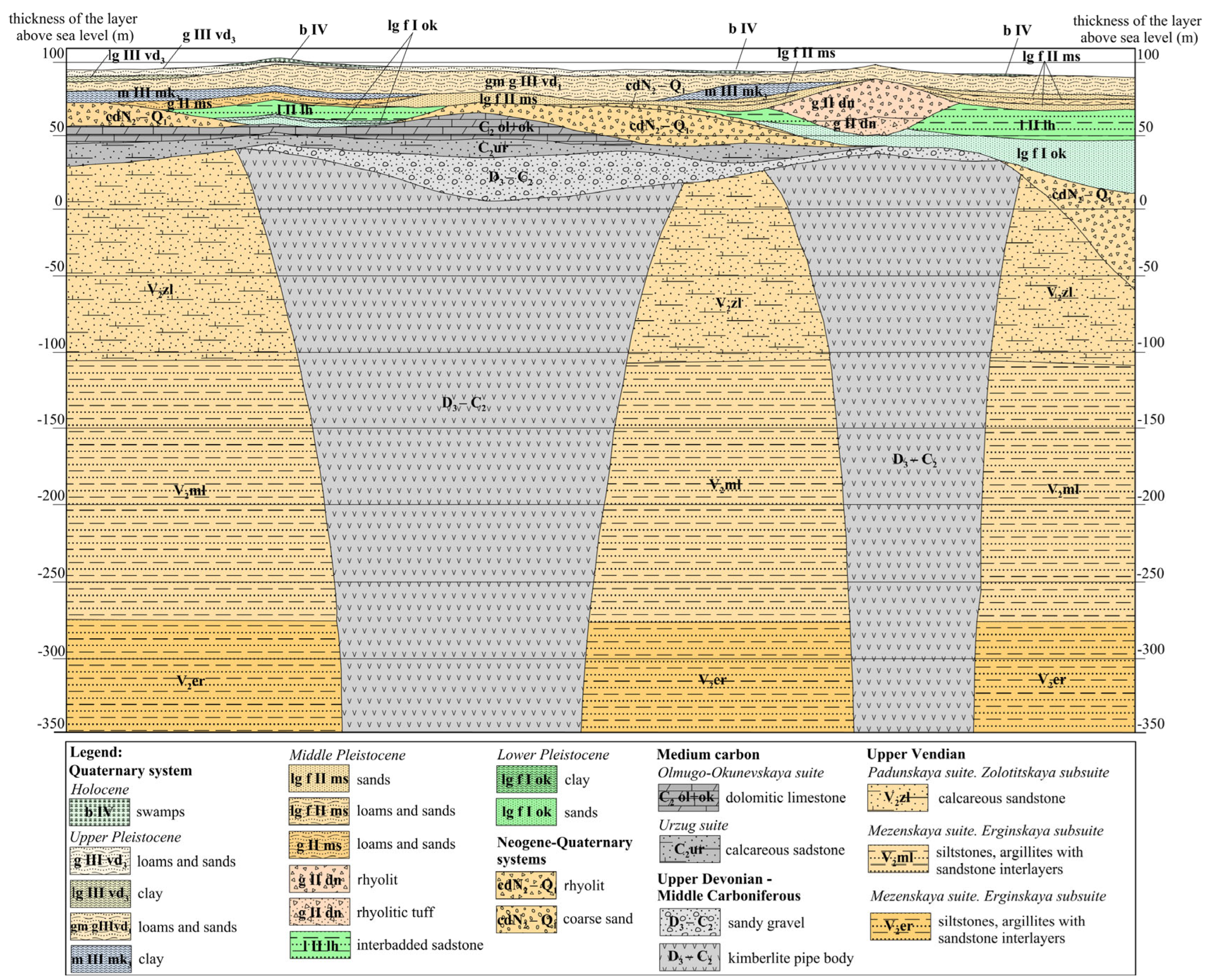
2. Study Area
3. Methods
3.1. Passive Seismic Methods
3.2. Radon Emanation Method
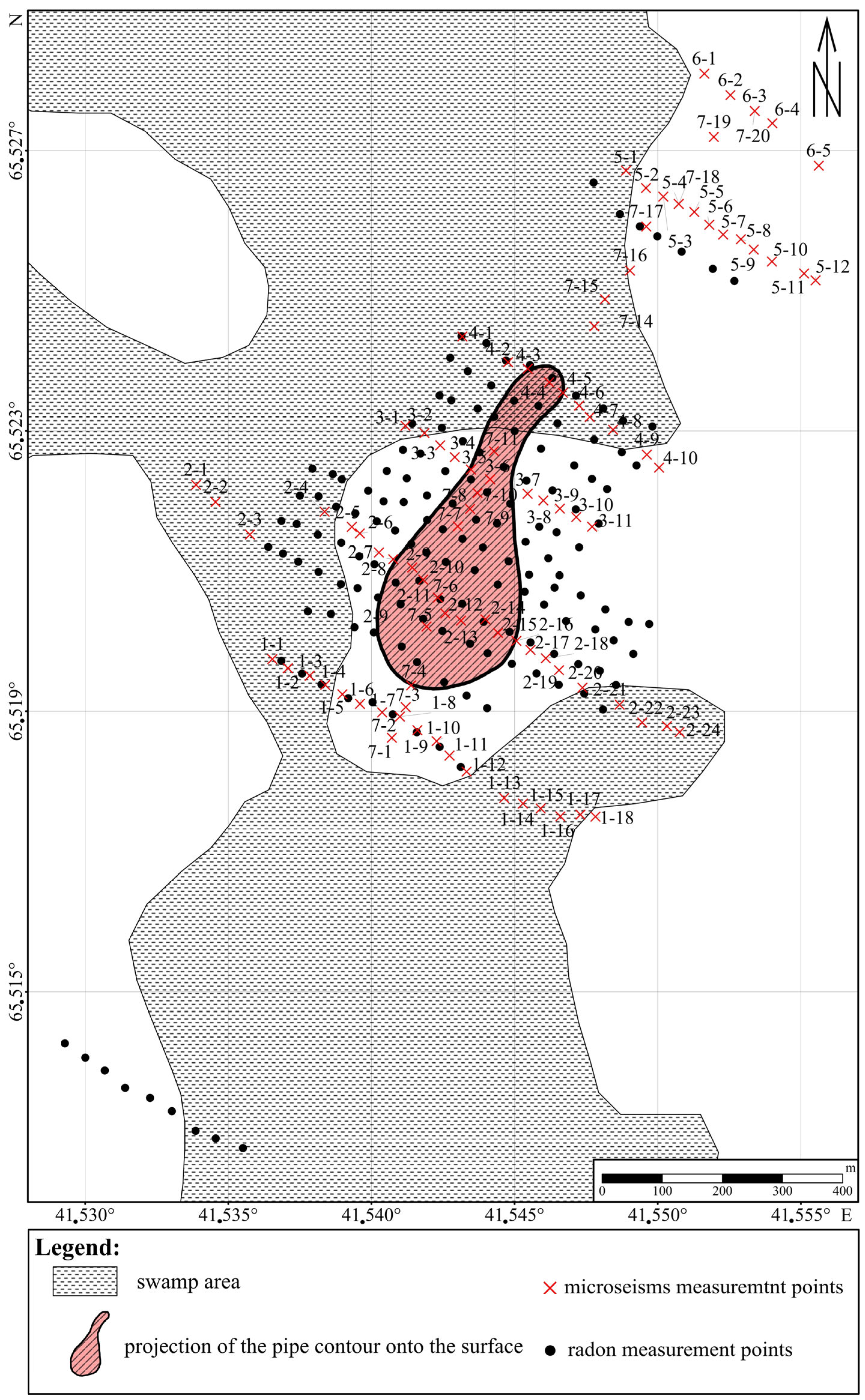
4. Description of the Field Measurements
5. Results
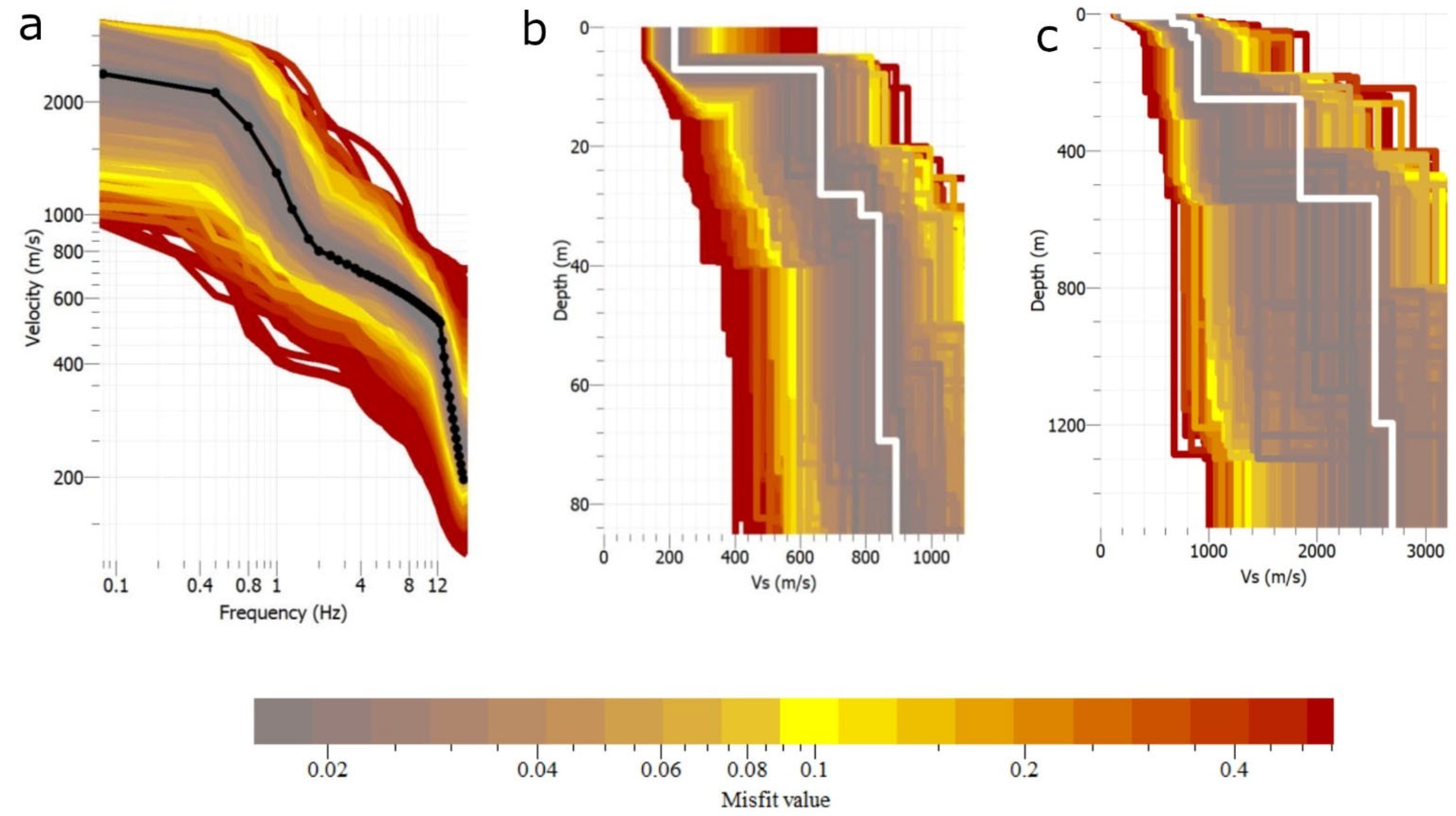
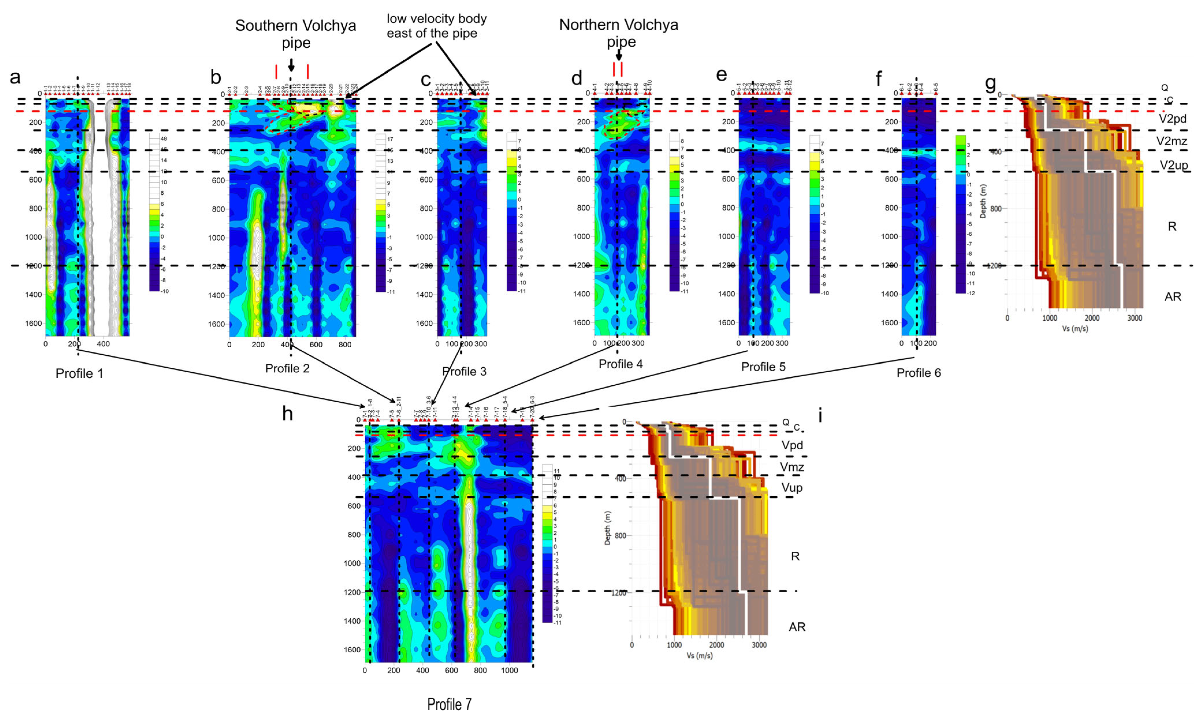
5.1. Results of the Passive Seismic Methods
5.2. Assessment of the Surface Distribution of RFD
6. Discussion
6.1. Faults
6.2. Pipe
6.3. Vendian Deposit
7. Conclusions
- −
- the true dimensions are larger than was previously estimated;
- −
- each pipe contains various blocks, which are probably different phases of intrusion;
- −
- it was shown that during the formation of the pipe, an important role is played by the boundary inside the Padunskaya suite of Vendian deposits at a depth of 120 m;
- −
- specific faults controlling each pipe were established;
- −
- faults controlling each pipe have a vertical structure and high contrast in the Ust-Pinega suite of Vendian deposit and Riphean deposit
- −
- the pipe contains blocks that have not come to the surface of Vendian deposits;
- −
- in terms of the features of manifestation, the studied pipe is close to the pipes of the Lomonosov deposit.
Author Contributions
Funding
Institutional Review Board Statement
Informed Consent Statement
Data Availability Statement
Conflicts of Interest
References
- Kutinov, Y.G.; Chistova, Z.B. Hierarchical series of manifestations of alkaline-ultrabasic magmatism in the Arkhangelsk diamondiferous province. Their reflection in geological and geophysical materials. Pravda Severa, 2004. (In Russian) [Google Scholar]
- Garanin, K.V.; Garanin, V.K.; Kudryavtseva, G.P. Petrochemistry and mineralogy of alkaline-ultrabasic magmatites in the Arkhangelsk diamondiferous province and models of their formation. Bull. Perm Univ. Geol. 2008, 10, 32–49. (In Russian) [Google Scholar]
- Verzhak, V.V.; Minchenko, G.V.; Larchenko, V.A. Experience in prospecting for diamond deposits in the Arkhangelsk diamondiferous province and adjacent territories of the north of the East European Platform. Problems of Forecasting and Prospecting of Diamond Deposits in Closed Territories. In Proceedings of the Conference Dedicated to the 40th Anniversary of YANIGP CRNIGRI AK ‘ALROSA’/YaNTs SB RAS. Yakutsk, Russia, 8–20 March 2008; pp. 308–314. (In Russian). [Google Scholar]
- Tappe, S.; Smart, K.; Torsvik, T.; Massuyeau, M.; de Wit, M. Geodynamics of kimberlites on a cooling Earth: Clues to plate tectonic evolution and deep volatile cycle. Earth Planet. Sci. Lett. 2018, 484, 1–14. [Google Scholar] [CrossRef]
- Decision of the Working Meeting. Scientific, Methodological and Technological Problems of Forecasting and Searching for Weakly Contrasting Kimberlite Pipes in the East European and East Siberian Diamondiferous Provinces; VSEGEI: St. Petersburg, Russia, 2017; p. 7. (In Russian) [Google Scholar]
- Korotkov, Y.V. To the issue of identification and tracking of rupture faults by characteristic changes in conductivity in sedimentary sediment strata. Geophys. Res. 2011, 12, 81–92. (In Russian) [Google Scholar]
- Stogniy, V.V.; Korotkov, Y.V. Search for Kimberlite Bodies by the Method of Transient Processes; Publishing house ‘Malotyrazhnaya typography 2D’: Novosibirsk, Russia, 2010; p. 121. (In Russian) [Google Scholar]
- Sobolev, V.K. Problems of diamond prospecting by indicator minerals on the territory of the Arkhangelsk region. In Geology and Minerals of the North of the European Part of the USSR; Arkhangelsk Geologia Publishing House: Arkhangelsk, Russia, 1991; p. 314. (In Russian) [Google Scholar]
- Bogatikov, O.A. Arkhangelsk Diamondiferous Province (Geology, Petrography, Geochemistry and Mineralogy); Publishing House MSU: Moscow, Russia, 1999; p. 524. (In Russian) [Google Scholar]
- Kudryavtseva, G.P. Diamond microcrystals from kimberlites of Arkhangelsk diamondiferous province deposits. Izv. Vuzov Ser. Geol. Explor. 2004, 3, 32–38. (In Russian) [Google Scholar]
- Androsov, E.A. On structural control of kimberlite bodies location on the example of the Arkhangelsk kimberlite province. In Efficiency of Forecasting and Prospecting for Diamond Deposits: Past, Present and Future (Diamonds-50); VSEGEI: St. Petersburg, Russia, 2004; pp. 9–18. (In Russian) [Google Scholar]
- Bushkov, K.Y. Structure of the Nakyn Kimberlite Field and Signs of Hidden Shear Kimberli-Controlling Structures. Ph.D. Thesis, MGRI, Moscow, Russia, 2006. (In Russian). [Google Scholar]
- Vasiliev, I.D. Geological Structures in the Near-Tube Space of the Arkhangelskaya Pipe and Their Use for Prospecting for Primary Diamond Deposits in the Zimneberezhny District. Ph.D. Thesis, MGRI-RGGRU, Moscow, Russia, 2010; p. 32. (In Russian). [Google Scholar]
- Ignatov, P.A. Paleotectonic structures of the Zimneberezhny diamondiferous area of the Arkhangelsk region. MOIP Bull. Dep. Geol. 2008, 3, 13–20. (In Russian) [Google Scholar]
- Danilov, K.B.; Yakovlev, E.Y.; Afonin, N.Y.; Druzhinin, S.V. Deep structure of the Verkhnetovskaya kimberlite pipe in the Arkhangelsk diamondiferous province according to passive seismic and radiological methods. Geophys. Prospect. 2023, 71, 1873–1885. [Google Scholar] [CrossRef]
- Gorbatikov, A.V.; Tsukanov, A.A. Simulation of the Rayleigh waves in the proximity of the scattering velocity inhomogeneities. Exploring the capabilities of the microseismic sounding method. Izv. Phys. Solid Earth 2011, 4, 354–369. [Google Scholar] [CrossRef]
- Gorbatikov, A.V.; Montesinos, F.G.; Arnoso, J.; Stepanova, M.Y.; Benavent, M.; Tsukanov, A.A. New features in the subsurface structure model of El Hierro Island (Canaries) from low-frequency microseismic sounding: An insight into the 2011 seismo-volcanic crisis. Surv. Geophys. 2013, 34, 463–489. [Google Scholar] [CrossRef]
- Sobisevich, A.L.; Gorbatikov, A.V.; Ovsuchenko, A.N. Deep structure of the Mt. Karabetov Mud volcano. Dokl. Earth Sci. 2008, 422, 1181–1185. [Google Scholar] [CrossRef]
- Kugaenko, Y.A.; Saltykov, V.A.; Gorbatikov, A.V.; Stepanova, M.Y. Deep Structure of the Zone of Tolbachik Fissure Eruptions (Kamchatka, Klyuchevskoy Volcano Group): Evidence from a Complex of Geological and Geophysical Data. Izv. Phys. Solid Earth 2018, 54, 444–465. [Google Scholar] [CrossRef]
- Danilov, K.B.; Yakovlev, E.Y.; Afonin, N.Y. Study of deep structure of the kimberlite pipe named after M. Lomonosov of the Arkhangelsk diamondiferous province obtained by joint using of passive seismic and radiometric methods. Pure Appl. Geophys. 2021, 178, 3933–3952. [Google Scholar] [CrossRef]
- Danilov, K.B. The application of microseismic sounding to the study of the Lomonosov volcanic pipe, Arkhangel’sk Diamond Province. Vestn. KRAUNTs Nauk. Zemle 2011, 17, 231–237. [Google Scholar]
- Frantsuzova, V.I.; Danilov, K.B. The Structure of the Lomonosov Volcanic Pipe in the Arkhangel’sk Diamond Province from Anomalies of the Microseismic Field. J. Volcanol. Seismol. 2016, 10, 339–346. [Google Scholar] [CrossRef]
- Francuzova, V.I.; Danilov, K.B. The location of the S10 and Chidviya Kimberlite Pipes from Inhomogeneities in the Host Rock Structure of the Nenoksa and Chidviya–Izhmozero Fields in the Arkhangelsk Diamond Province as Detected by Background Microseisms. J. Volcanol. Seismol. 2018, 12, 332–340. [Google Scholar] [CrossRef]
- Yakovlev, E.; Puchkov, A. Radon over kimberlite pipes: Surface field experiments and calculations of vertical diffusion (Arkhangelsk diamondiferous province, NW Russia). Appl. Sci. 2021, 11, 11765. [Google Scholar] [CrossRef]
- Bobrov, A.A. The study of radon volumetric activity in fracture zones of Priolkhon and southern Priangarya: Methodology and preliminary results. Izvestiya Sibirskogo otedeleniya Secheniya Zemlya nauki RANEN Proceedings of the Siberian Branch of the Earth Sciences Section of the Russian Academy of Natural Sciences. Geol. Prospect. Explor. Ore Depos. 2008, 6, 124–129. (In Russian) [Google Scholar]
- Miklyaev, P.S. Scientific Bases of Assessment of Potential Radon Hazard of Platform Territories. Ph.D. Thesis, IGE RAS, Moscow, Russia, 2015; p. 307. (In Russian). [Google Scholar]
- Baskaran, M. Radon: A Tracer for Geological, Geophysical and Geochemical Studies; Springer: Berlin/Heidelberg, Germany, 2016; p. 260. [Google Scholar]
- Selvam, S. Quantification of submarine groundwater discharge (SGD) using radon, radium tracers and nutrient inputs in Punnakayal, south coast of India. Geosci. Front. 2021, 12, 29–38. [Google Scholar] [CrossRef]
- Peel, M. Exploring the reliability of 222Rn as a tracer of groundwater age in alluvial aquifers: Insights from the explicit simulation of variable 222Rn production. Water Res. 2023, 235, 119880. [Google Scholar] [CrossRef]
- Kiselev, G.P. Radiometric and seismic study of Chidvinskaya kimberlite pipe (Arkhangelsk diamondiferous province, North of the East European Craton, Russia). Geofísica Int. 2017, 2, 147–155. [Google Scholar]
- Seminsky, K.J. Radon activity of different types of crustal faults (on the example of the Western Pribaikalsky and Southern Priangarya). Geol. Geophys. 2009, 50, 881–896. (In Russian) [Google Scholar]
- Kaplan, A.D. Report on the results of prospecting and evaluation work on kimberlite pipes of anomalies 401 (Vol-chya), 402 (Verkhotina), 407 (Osetinskaya), 451 (Maiskaya), N-154 (Pervo-maiskaya). In Verkhotinsky Detachment, 1985–1988; Geological report; IN 440212; Russian Federal Geological Fund: Moscow, Russia, 1988. [Google Scholar]
- Gubajdullin, M.G. Geoenvironmental Conditions for the Development of Mineral Resources in the European North of Russia; M.V. Lomonosov Pedagogical University: Arkhangelsk, Russia, 2002. (In Russian) [Google Scholar]
- Larchenko, V.A. Diamond potential of kimberlites and related rocks of the Winter Coast. Vestn. Voronezh Univ. Geol. 2004, 134–147. [Google Scholar]
- Karshakov, E.V.; Kercman, V.M.; Moilanen, E.V.; Podmogov, E.V. Possibilities of airborne electrical exploration in detailed kimberlite prospecting. In Materials of the VIII All-Russian School-Seminar on Electromagnetic Sounding of the Earth Named After M.N. Berdichevsky and L.L. Vanyana (EMZ-2021); Institute of Oceanology RAS: Moscow, Russia, 2021; pp. 234–240. (In Russian) [Google Scholar]
- Gorbatikov, A.V.; Stepanova, M.Y. Statistical characteristics and stationarity properties of low-frequency seismic signals. Izv. Phys. Solid Earth 2008, 44, 50–59. [Google Scholar] [CrossRef]
- Gorbatikov, A.V.; Larin, N.V.; Moiseev, E.I.; Belyashov, A.V. The microseismic sounding method: Application for the study of the buried diatreme structure. Dokl. Earth Sci. 2009, 428, 1222–1226. [Google Scholar] [CrossRef]
- Afonin, N.; Kozlovskaya, E.; Nevalainen, J.; Narkilahti, J. Improving quality of empirical Greens functions, obtained by cross-correlation of high-frequency ambient seismic noise. Solid Earth Discuss 2019, 10, 1621–1634. [Google Scholar] [CrossRef]
- Likhodeev, D.V.; Zhostkov, R.A.; Presnov, D.A.; Dudarov, Z.I.; Dolov, S.M.; Danilov, K.B. Studying the Deep Structure of Elbrus Volcano by Microseismic Sounding. J. Volcanol. Seismol. 2017, 11, 413–418. [Google Scholar] [CrossRef]
- Bath, M. Spectral Analysis in Geophysics; Elsevier: Amsterdam, The Netherlands, 1974; pp. 432–443. [Google Scholar]
- Lin, F.C.; Tsai, V.C.; Ritzwoller, M.H. The local amplification of surface waves: A new observable to constrain elastic velocities, density, and anelastic attenuation. JGR 2012, 117, B06302. [Google Scholar] [CrossRef]
- Eddy, C.L.; Ekström, G. Local amplification of Rayleigh waves in the continental United States observed on the USArray. Earth Planet. Sci. Lett. 2014, 402, 50–57. [Google Scholar] [CrossRef]
- Shapiro, N.M.; Campillo, M. Emergence of broadband Rayleigh waves from correlations of the ambient seismic noise. Geophys. Res. Lett. 2004, 31, L07614. [Google Scholar] [CrossRef]
- Wapenaar, K.; Draganov, D.; Robertsson, J.O. Seismic Interferometry: History and Present Status; Society of Exploration Geophysicists: Houston, TX, USA, 2008. [Google Scholar] [CrossRef]
- Wapenaar, K.; Draganov, D. Tutorial on seismic interferometry. J. Geophys. 2010, 75, 75A195–75A209. [Google Scholar] [CrossRef]
- Shapiro, N.M.; Campillo, M.; Stehly, L.; Ritzwoller, M.H. High-resolution surface-wave tomography from ambient seismic noise. Science 2005, 307, 1615–1618. [Google Scholar] [CrossRef]
- Yang, Y.; Ritzwoller, M.H.; Levshin, A.L.; Shapiro, N.M. Ambient noise Rayleigh wave tomography across Europe. Geophys. J. Int. 2007, 168, 259–274. [Google Scholar] [CrossRef]
- Lin, F.C.; Ritzwoller, M.H.; Townend, J.; Bannister, S.; Savage, M.K. Ambient noise Rayleigh wave tomography of New Zealand. Geophys. J. Int. 2007, 170, 649–666. [Google Scholar] [CrossRef]
- Poli, P.; Campillo, M.; Pedersen, H.; LAPNET Working Group. Body-wave imaging of Earth’s mantle discontinuities from ambient seismic noise. Science 2012, 338, 1063–1065. [Google Scholar] [CrossRef] [PubMed]
- Cheng, F.; Xia, J.; Xu, Y.; Xu, Z.; Pan, Y. A new passive seismic method based on seismic interferometry and multichannel analysis of surface waves. J. Appl. Geophys. 2015, 117, 126–135. [Google Scholar] [CrossRef]
- Le Feuvre, M.; Joubert, A.; Leparoux, D.; Cote, P. Passive multi-channel analysis of surface waves with cross-correlations and beamforming. Application to a sea dike. J. Appl. Geophys. 2015, 114, 36–51. [Google Scholar] [CrossRef]
- Lin, F.C.; Li, D.; Clayton, R.W.; Hollis, D. High-resolution 3D shallow crustal structure in Long Beach, California: Application of ambient noise tomography on a dense seismic array. Geophysics 2013, 78, Q45–Q56. [Google Scholar] [CrossRef]
- Ciotoli, G.; Bigi, S.; Cavinato, G.P. Radon distribution as shallow evidence of buried fault geometry in the Fucino plain (Central Italy). 6th International INQUA Meeting on Paleoseismology, Active Tectonics and Archaeoseismology. Misc. INGV 2015, 27, 79–82. [Google Scholar]
- Drolet, J.-P.; Martel, R. Distance to fault as a proxy for radon gas concentration in dwellings. J. Environ. Radioact. 2016, 152, 8–15. [Google Scholar] [CrossRef]
- Moreno, V.; Bach, J.; Zarroca, M.; Font, L.; Roqué, C.; Linares, R. Characterization of radon levels in soil and groundwater in the North Maladeta Fault area (Central Pyrenees) and their effects on indoor radon concentration in a thermal spa. J. Environ. Radioact. 2018, 189, 1–13. [Google Scholar] [CrossRef] [PubMed]
- Miklyaev, P.S.; Petrova, T. B Studies of anomalous seasonal variations in radon flux density in a fault zone. Geochemistry 2021, 66, 364–378. (In Russian) [Google Scholar] [CrossRef]
- Tsapalov, A.; Kovler, K.; Miklyaev, P. Open charcoal chamber method for mass measurements of radon exhalation rate from soil surface. J. Environ. Radioact. 2016, 160, 28–35. [Google Scholar] [CrossRef]
- Khazanovich-Wolf, K.K. Diatreme Plumes of Astroblems or ‘Bolide Model’ of Kimberlite Pipes Formation; Geomaster Publishing House: Petrozavodsk, Russia, 2007; p. 272. (In Russian) [Google Scholar]


| Depth, m | S-Wave Velocity, m/s | Geological Formations |
|---|---|---|
| 0–7 | 216 | Q |
| 7–28 | 660 | C2ol |
| 28–32 | 785 | C2Vr |
| 32–70 | 840 | C2Ur |
| 70–245 | 870 | Vzl (Vpd) |
| 245–530 | 1850 | Vmz |
| 530–1200 | 2500 | Vup |
| 1200–1500 | 2700 | R |
| 1500 and above | - | AR |
Disclaimer/Publisher’s Note: The statements, opinions and data contained in all publications are solely those of the individual author(s) and contributor(s) and not of MDPI and/or the editor(s). MDPI and/or the editor(s) disclaim responsibility for any injury to people or property resulting from any ideas, methods, instructions or products referred to in the content. |
© 2025 by the authors. Licensee MDPI, Basel, Switzerland. This article is an open access article distributed under the terms and conditions of the Creative Commons Attribution (CC BY) license (https://creativecommons.org/licenses/by/4.0/).
Share and Cite
Danilov, K.; Yakovlev, E.; Puchkov, A.; Bykov, V.; Katorin, A. The Deep Structure of the Kimberlite Pipe Volchya in the Arkhangelsk Diamond Province and Controlling Faults Based on Passive Seismic and Radiological Methods (Northwest Russia). Appl. Sci. 2025, 15, 657. https://doi.org/10.3390/app15020657
Danilov K, Yakovlev E, Puchkov A, Bykov V, Katorin A. The Deep Structure of the Kimberlite Pipe Volchya in the Arkhangelsk Diamond Province and Controlling Faults Based on Passive Seismic and Radiological Methods (Northwest Russia). Applied Sciences. 2025; 15(2):657. https://doi.org/10.3390/app15020657
Chicago/Turabian StyleDanilov, Konstantin, Evgeny Yakovlev, Andrey Puchkov, Vladimir Bykov, and Alexander Katorin. 2025. "The Deep Structure of the Kimberlite Pipe Volchya in the Arkhangelsk Diamond Province and Controlling Faults Based on Passive Seismic and Radiological Methods (Northwest Russia)" Applied Sciences 15, no. 2: 657. https://doi.org/10.3390/app15020657
APA StyleDanilov, K., Yakovlev, E., Puchkov, A., Bykov, V., & Katorin, A. (2025). The Deep Structure of the Kimberlite Pipe Volchya in the Arkhangelsk Diamond Province and Controlling Faults Based on Passive Seismic and Radiological Methods (Northwest Russia). Applied Sciences, 15(2), 657. https://doi.org/10.3390/app15020657