Abstract
The Jinchuan Cu–Ni sulfide deposit, one of only two ultra-large magmatic Ni–Cu–PGE deposits in Eurasia, is hosted in a small ultramafic intrusion at the southwestern margin of the Alxa block, North China Craton, and contains over five million tonnes of nickel. Previous studies suggest that its formation is linked to large-scale deep magmatic processes, but direct evidence from the mantle source region has been limited. Using P-wave seismic tomography, we imaged the crust and mantle beneath the Qilian–Longshoushan area, revealing a deep low-velocity anomaly at ~400 km depth, interpreted as residual mantle plume material. This anomaly spatially corresponds to the Jinchuan deposit, representing a long-term material and heat supply pathway for ore formation. A high-velocity anomaly at ~200 km depth, likely related to Indian plate subduction, influenced the Cenozoic tectonic evolution of the Longshoushan region. These results integrate geophysical, geochemical, and geological evidence, highlighting how deep mantle dynamics and associated magmatic activity controlled the supply of material to the Jinchuan Cu–Ni deposit and contributed to its formation.
1. Introduction
The Jinchuan Cu–Ni sulfide deposit, located in the Longshoushan uplift at the southwestern margin of the Alxa block, North China Craton, is the largest magmatic Cu–Ni sulfide deposit in China and the third largest in the world [1,2,3]. As a typical magmatic sulfide deposit associated with mafic–ultramafic intrusions, it occurs in Late Mesoproterozoic layered intrusions of basalt–gabbro–peridotite composition [4]. Since its discovery in 1958, the deposit has exhibited the classic “small intrusion, large deposit” characteristic, with high-grade, metal-rich, and voluminous mineralization.
Early studies extensively investigated its ore-forming processes and magmatic history. Tang summarized the Jinchuan deposit as a “small intrusion, large deposit” system and proposed a model of deep magmatic differentiation with multiple intrusions to explain its formation [4]. Other researchers emphasized the importance of the magmatic conduit system in controlling mineralization [5,6], a perspective increasingly supported by subsequent studies on “magmatic conduit ore-forming systems” [2,7,8,9,10,11,12,13].
The precise age of mineralization has been debated. Tang (1995) first reported a Sm–Nd isochron age of 1508 ± 31 Ma for the Jinchuan intrusion [4], while Re–Os dating of sulfide ores yielded an age of 833 ± 35 Ma [14], and the U–Pb zircon ages of sulfide-bearing ultramafic rocks indicate 827 ± 8 Ma [15,16,17].
Geochemical studies have confirmed that the mantle source of the Jinchuan Cu–Ni sulfide deposit is enriched mantle [4,18,19,20,21,22,23]. However, given the relatively small intrusion, the unusually large metal endowment has led some researchers to propose that the original magma volume was exceptionally large [4,22]. The deposit formed during the Neoproterozoic breakup of the Rodinia supercontinent, when mantle plume activity supplied the heat and material required for mineralization. The Jinchuan ore-bearing intrusion is located above mantle plume positions associated with the Alxa, Tarim, Yangtze, and West Australian blocks [24,25]. Thus, the formation of the Jinchuan deposit represents the product of superplume activity during the Rodinia breakup [3,16,22].
Most previous studies have relied on geological and geochemical evidence. Seismic tomography, as a geophysical method capable of imaging deep subsurface structures, provides a complementary approach for investigating the heat source and material supply for ore formation. In this study, natural earthquake tomography was applied to the southwestern margin of the Alxa block, North China Craton, to obtain a high-resolution three-dimensional P-wave velocity structure, enabling a more direct characterization of deep magmatic activity and its relationship to the material supply for the Jinchuan Cu–Ni deposit. This approach offers new theoretical and methodological support for deep exploration of the deposit.
2. Geological and Geophysical Setting
2.1. Geological Setting
The Jinchuan Cu–Ni sulfide deposit is tectonically located within the Longshoushan continental marginal belt of the Alxa block, situated on the southwestern margin of the North China Craton (Figure 1). Regionally, the structural trend is oriented NNW, but east of Jinchuan, it changes to nearly E–W. The Alxa block is bounded by the North China Craton to the east and the Tarim block to the west, and it is adjacent to the Late Paleozoic Junggar fold belt to the north and the Early Paleozoic North Qilian fold belt to the south. The Longshoushan marginal belt itself is bordered to the north by the Chaoshui Basin and to the south by the North Qilian orogenic belt, both of which are separated by major deep-seated faults [26]. This region has undergone frequent tectonic deformation and extensive magmatic activity, providing the geological framework for the formation of the world-class Jinchuan deposit.
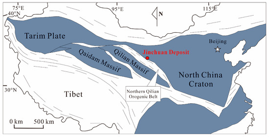
Figure 1.
Tectonic location of the Jinchuan area, modified from references [27,28].
Since its discovery in the 1950s, the Jinchuan Cu–Ni sulfide deposit has been the subject of intensive exploration and research. The ore-bearing mafic–ultramafic intrusion has a general orientation of NW50°, dipping toward the SW at 50°–80°, with an intersection angle of approximately 10° relative to the country rocks. The intrusion extends about 6.5 km in length, 20–527 m in width, and covers an exposed area of roughly 1.34 km2. Its major rock-forming minerals are olivine and pyroxene, accompanied by minor plagioclase and amphibole [5,29]. Structural control plays a significant role in the emplacement of the intrusion: it is dissected by NEE-trending strike–slip faults into four segments, which are designated, from west to east, as ore zones III, I, II, and IV (Figure 2). The intimate relationship between tectonic evolution, magmatic activity, and ore formation in the Longshoushan region highlights the complex geodynamic processes that contributed to the unique metallogenic setting of the Jinchuan deposit.
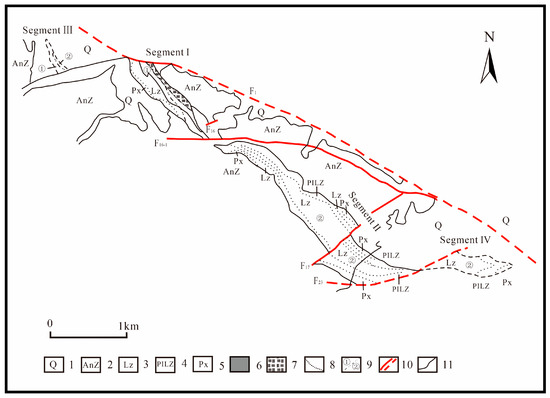
Figure 2.
Plan view geological map of the Jinchuan intrusion, modified from [30]. 1. Quaternary deposits; 2. Baijiazui Formation of Longshoushan Group; 3. lherzolite; 4. plagioclase lherzolite; 5. harzburgite; 6. disseminated ore; 7. oxidized ore; 8. lithological boundary; 9. lithological boundary of different intrusive stages; 10. measured/inferred faults; 11. stratigraphic boundary.
2.2. Geophysic Setting
The gravity gradient of the Qilian Mountains is the main feature of the Bouguer gravity anomaly in the region (Figure 3), and the gravity low is separated from the gravity high. Gravity anomaly values gradually decrease from north to south and from east to west; the gradient change is steep in the south, low in the north, steep in the west, and low in the east, qualitatively reflecting the crust thickness increasing from north to south and from east to west. The isolines of the regional gravity anomaly are mainly distributed in the northwest, bending or twisting at both the eastern and western ends, with closed local anomaly clusters or scattered distributions, indicating that the local gravity anomaly is superimposed on the regional background field. The Jinchuan Ni–Cu deposit is located on the northern side of the Qilian Mountain fault zone, and its geotectonic position is along the inner edge of the southern margin of the North China Craton.
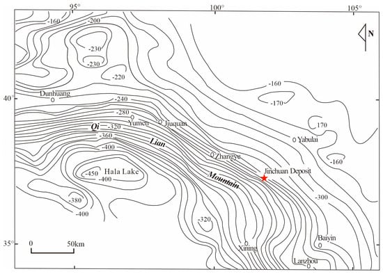
Figure 3.
Bouguer gravity anomaly map of Qilian Mountain area (unit ), modified from [26].
3. Method
Seismic tomography provides direct evidence for the deep roots of mantle plumes and their contribution to ore-forming material supply. Studies show that low-velocity anomalies exist beneath hotspots such as Hawaii, extending from the lithosphere down to ~1500–2000 km and connecting with low-velocity regions near the core–mantle boundary, indicating a deep-mantle origin for the plumes [31]. The LLSVPs beneath Africa and the Pacific are considered primary thermal reservoirs for mantle plumes, supplying heat and material to ascending magmas [32]. Mantle plume material not only ascends vertically but may also migrate laterally along mid-ocean ridges [33]. These structures control the transport of Ni-, Cu-, PGE-rich magmas to the upper crust, forming large mineral deposits. Therefore, passive seismic tomography not only reconstructs the 3D structure of mantle plumes but also provides key evidence for the coupling between deep thermal sources and ore-forming material supply, offering important guidance for the exploration of metal deposits.
We employed a joint tomographic inversion of local and teleseismic P-wave travel-time data [34] to obtain a three-dimensional P-wave velocity structure of the crust and upper mantle beneath North China. The dataset integrates records from the China National Seismic Network, the NECESSArray collection, and portions of the ISC catalog.
For local events, we compiled P-wave arrival times from the Chinese seismic network (1980–2016) and the ISC catalog (2000–2013). To avoid duplications, overlapping events were merged, and redundant entries were removed. Stringent selection criteria were applied during event screening: (1) the model space was divided into blocks of 0.2° × 0.2° × 5 km; (2) events with the largest number of P-wave picks and the most reliable hypocenter locations (depth error < 5 km) were retained for each block; (3) each event was required to include at least 10 P-wave arrivals; and (4) the difference between theoretical and observed travel times were required to be less than 3.0 s. Since most local earthquakes recorded by the Chinese network are shallow and at short epicentral distances, which are insufficient to constrain deep structures, we supplemented the dataset with larger-distance events from the ISC and the national network to improve the resolution of the mantle transition zone and uppermost lower mantle.
For teleseismic data, we incorporated four datasets: (1) ISC records from 2000–2013, including 2549 teleseismic events at 122 stations, yielding 58,259 relative P-wave residuals; (2) the dataset of Zhao et al. [35], with 5727 events recorded by 316 stations, producing 138,658 residuals; (3) 1314 teleseismic events recorded by 129 permanent stations in Northeast China during 2009–2015, with 96,020 residuals automatically picked using the MMCC method [36]; and (4) 398 teleseismic events recorded by 128 NECESSArray stations between September 2009 and August 2012, providing 36,920 residuals. Selection of teleseismic data followed standard criteria: (1) epicentral distances between 30° and 90°; (2) each event recorded by at least 15 stations; and (3) magnitude M > 5.0. Altogether, 9988 teleseismic events were collected, yielding a total of 319,857 P-wave travel-time residuals.
The inversion employed the pseudo-bending ray-tracing algorithm [37], which introduces an enhanced factor into the scheme of Um and Thurber [38]. Appropriate factors were chosen according to different source–receiver distances and depths to ensure convergence and accuracy. The model grid spacing was 1.0° in the horizontal direction, with 10 layers in depth at 10, 22, 50, 80, 160, 240, 320, 400, and 480 km. The IASP91 global one-dimensional model was adopted as the initial velocity model. The final tomographic model achieves a lateral resolution of ~100 km across North China.
Our results demonstrate that the use of large, high-quality datasets combining both local and teleseismic P-wave arrivals enables robust imaging of the crust and upper mantle beneath North China. Representative depth slices of the tomographic results are shown in Figure 4 and Figure 5. The free GMT software (v5.4.2) [39] is used for making most of the figures.
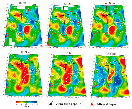
Figure 4.
Samples of 3−80 km of P-wave velocity tomography (black solid line shows the seismic tomography profile through the Jinchuan deposit.).
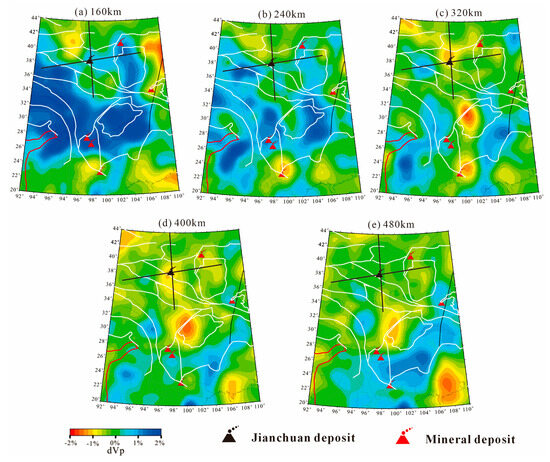
Figure 5.
Samples of 160–480 km of P-wave velocity tomography (black solid line shows the seismic tomography profile through the Jinchuan deposit.).
4. Results
4.1. P-Wave Seismic Tomography
Seismic tomography is a technique for investigating the Earth’s internal structure by providing three-dimensional velocity models, which can effectively reveal lithospheric structures or asthenospheric upwelling channels. P-wave velocity tomography refers to the method of reconstructing subsurface structures by utilizing spatial variations in the propagation velocity of seismic P-waves. Since P-wave velocities are controlled by temperature, pressure, and rock composition, anomalies in P-wave velocity can be used to infer distinct geophysical features: upwelling of hot asthenospheric material is usually manifested as significant low-velocity anomalies, whereas dense and stable lithosphere is expressed as high-velocity anomalies. In this study, both regional absolute travel times and teleseismic relative travel-time residuals were employed for seismic tomography inversion. Through the inversion, 11 P-wave velocity tomographic images at different depths were obtained (Figure 4 and Figure 5), providing important insights into the lithosphere–asthenosphere structure and the processes of deep material migration.
It can be seen that at depths of 3 km to 10 km, there is a remarkable low-velocity anomaly, which is oriented in the northwest direction and conforms to the gravity gradient belt (Figure 3) of the Qilian Mountains in the geophysical field. By comparing the Bouguer gravity anomaly with seismic tomography, the low-velocity anomaly between 3 km and 10 km should be the main cause of the Qilian gravity gradient. The extent of this anomaly gradually increases as the depth increases from the 25 km to the 50 km depth slice. However, the range of the low-velocity anomaly narrows on the 80 km depth slice, indicating that the anomaly body is buried at a depth of approximately 80 km.
In comparison to the geological structure (Figure 6), at depths of 3 km to 10 km, the low-velocity anomaly corresponds to the regional metallogenic structures of the North Qilian Orogenic Belt, the Longshoushan region, and the Hexi Corridor arc-back basin.
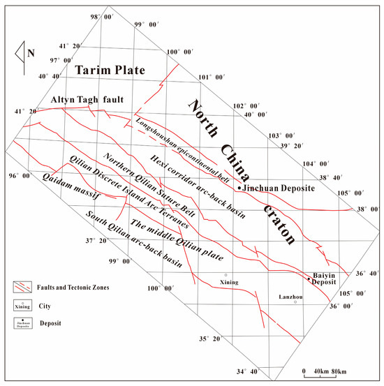
Figure 6.
Geotectonic framework and metallogenic system in the southwest margin of North China Paleocontinent, modified from reference [40].
As shown in Figure 5, a prominent high-velocity anomaly is observed in the northwestern segment of the North Qilian suture zone at depths between 160 km and 320 km. The spatial extent of this anomaly decreases progressively with depth and nearly disappears at 320 km. Based on previous studies, this feature is preliminarily interpreted as the result of a continental collision between the Qilian–Qaidam blocks and the Alashan block during the closure of the Paleo-Qilian Ocean [41]. At depths between 320 km and 400 km, a gradually expanding low-velocity anomaly is detected in the southern part of the Longshoushan continental margin zone. This anomaly is hypothesized to represent residual material associated with mantle plume upwelling, potentially linked to superplume activity that triggered the breakup of the Rodinia supercontinent.
To further analyze the high-velocity and low-velocity anomalies in the deep mantle, we intercepted seismic tomography sections in the near east–west and near north–south directions through Jinchuan, as shown in Figure 7 and Figure 8.
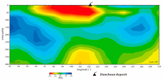
Figure 7.
The P-wave velocity tomography section of the east-west.
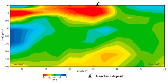
Figure 8.
The P-wave velocity tomography section of the north-south.
Due to the intersection of the east–west seismic tomography section with the geotectonic geological body of the southwestern margin of the North China Craton, the characteristics of geotectonic activity are more clearly reflected. Figure 7 clearly shows the northern Qilian suture belt and the Hexi Corridor arc-back basin, where a low-velocity anomaly is present, reaching a depth of about 90 km. Beneath the low-velocity anomaly at depths of about 300 km to 400 km, there is another low-velocity body, possibly serving as the material source for the shallow low-velocity anomaly. In the depth range of 80 km to 380 km, two high-velocity anomalies are present, one to the east and one to the west. The high-velocity anomaly to the west is curved at the end, exhibiting deformation caused by tectonic collision, while the high-velocity anomaly to the east is blocky and upward-sloping. Based on prior regional knowledge, the high-velocity anomaly in the west is likely the lithospheric mantle of the Qaidam block, with its deformation caused by NE-trending forces from the Qaidam block and its collision with the stable Alashan block to the east of the northern Qilian suture belt. The high-velocity anomaly in the east may represent the stable lithospheric mantle of the Alashan block.
In the north–south seismic tomography section, low-velocity anomalies are observed both in shallow and deep layers, with the deep low-velocity anomaly also showing a near north–south distribution.
4.2. The Process of Mantle Magma Activity
According to the above seismic tomography results, it is certain that there is a deep low-velocity anomaly at a depth of 400 km on the southwestern margin of the North China Craton. However, the relationship between the material supply at depths of 400 km and the shallow layer (0 km to 90 km) requires further discussion.
4.2.1. Shallow Low-Velocity Matter (0 km–90 km)
The geotectonic framework and metallogenic system (Figure 6) of the southwestern margin of the North China Craton are projected onto the seismic tomography images at different depths, providing a clearer understanding of the low-velocity anomaly bodies in the shallow part. By comparing the depths in Figure 9, it can be seen that at depths of 3 km to 10 km, the low-velocity anomaly is mainly concentrated in the geotectonic regions of the South Qilian Arc Basin and the Middle Qilian Discrete Island Arc [40], areas with abundant magmatic activity. This activity includes the generation of continental rifts and the emergence of continental flood basalts between 850 Ma and 604 Ma, as well as the broad development of oceanic ridge-type, island arc-type, and arc-back basin-type lavas in the South Qilian Ocean-ditch-arc-basin system from 550 Ma to 446 Ma. Additionally, intracontinental rift volcanism [42] developed between 522 Ma and 442 Ma in the central part of the Qilian block.
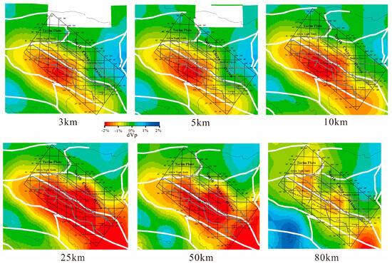
Figure 9.
Samples of 3–80 km seismic tomography and tectonic framework of superposition at different depths.
At a depth of approximately 25 km, the low-velocity anomaly expands in size and shows a southeastward diffusion trend. It is primarily concentrated in the southern part of the Hexi Corridor arc-back basin and the southern margin of the Longshoushan continental belt. These regions are also characterized by extensive magmatic activity and the presence of related mineral deposits, including the Jinchuan Cu–Ni sulfide deposit and the Baiyin polymetallic ore district.
The Jinchuan Cu–Ni sulfide deposit is a magmatic sulfide deposit formed within the geotectonic setting of a continental rift margin [1]. Its magma source is attributed to an enriched mantle [19,20,21,22,23], with the timing of magmatism and mineralization assigned to the Neoproterozoic Era. During the Paleozoic Era, the Jinchuan region underwent intense magmatic activity. Several mafic to ultramafic dikes intrude the Neoproterozoic ultramafic intrusions within the mining area, with emplacement ages predominantly around 400 Ma. These dikes are interpreted to have formed in response to subduction, slab rollback, and asthenospheric mantle melting associated with the Qilian–Qaidam tectonic system [41,43].
The Baiyin ore district is situated in the eastern segment of the Early Paleozoic North Qilian orogenic belt. Mineralization occurs within volcanic–sedimentary sequences of quartz keratophyre in a bimodal suite of early- to middle-Cambrian keratophyric complexes, formed in an early-stage continental rift setting. The metallogenic tectonic setting of the Baiyin district is linked to the northward subduction of the Paleo-Qilian Ocean during the Caledonian orogeny, which transformed the southwestern margin of the North China Plate into an active continental margin. This process facilitated the formation of volcanic domes during the early stages of arc rifting, creating a favorable environment for ore formation [40].
The formation ages of the intrusive bodies associated with the two representative ore deposits discussed above suggest that the region has undergone multiple episodes of magmatic activity. The magmatic processes related to the Jinchuan Cu–Ni sulfide deposit are particularly complex, involving multiple intrusive events. These magmatic episodes are not only directly linked to mineralization but are also closely tied to regional tectonic evolution. In contrast, the magmatism associated with the Baiyin Cu–polymetallic ore district took place during the Paleozoic Era.
Comparative analysis of deeper seismic tomographic slices (at 50 km and 80 km depth) reveals that the large low-velocity anomaly observed at shallower depths gradually becomes smaller and bifurcates into two distinct parts with increasing depth. One segment is located in the northwestern part of the North Qilian suture zone, while the other is situated in the southern portion of the Hexi Corridor arc-back basin. These low-velocity anomalies are interpreted to result from the complex magmatic processes along the southwestern margin of the North China Craton.
It is inferred that following the closure of the Paleo-Qilian Ocean, continental collision between the Qilian–Qaidam and Alashan blocks triggered subduction-related processes. These led to metasomatism and partial melting in the lithospheric mantle. After the cessation of subduction, the detachment and rollback of the subducted slab may have further induced mantle upwelling and magmatism in the region [41].
4.2.2. Deep Low-Velocity Matter (~400 km)
We analyze the formation of low-velocity material in the deep mantle by overlaying the tectonic framework diagram with the seismic tomography results. From the perspective of Figure 10, the deep low-velocity anomaly appears between 320 km and 400 km, mainly to the south of the Longshoushan epicontinental belt. This anomaly gradually shifts southward with increasing depth. These deep low-velocity anomalies may represent mantle-derived magmatic material. Previous studies on the southwestern margin of the North China Craton have investigated deep magmatic activity. Since the Changcheng Period, the Longshoushan area in North China has been in a tensile environment, where mantle-source magma upwells from depth, leading to rifting in the North Qilian Mountains, which predates the Cambrian Era. This process thinned the continental crust, transforming it into oceanic crust. However, the seismic tomography images show that the deep low-velocity anomaly is small, and its distribution does not correspond to the northern Qilian suture. Additionally, the low-velocity anomaly is confined to the 300 km to 400 km depth range, which does not seem to align with the mantle plume from the core–mantle boundary [3]. However, the deep low-velocity material appears to be spatially related to the shallow low-velocity material. Based on the mantle plume model [44], we infer that the low-velocity anomaly is evidence of upwelling residue from the deep mantle source.
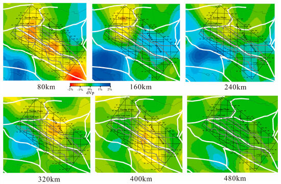
Figure 10.
Samples of the 80–480 km seismic tomography and tectonic framework of superposition at different depths.
4.2.3. Deep Mantle Material Effect on the Supply of Jinchuan Ni–Cu Deposit
Through the above discussion, it can be determined that the Jinchuan Ni–Cu sulfide deposit is located at the upper part of a deep (400 km) low-velocity anomaly, but other evidence should be sought to discuss the relationship between the deep anomaly matter and the Jinchuan Cu–Ni–sulfide deposit. First, the volume of Jinchuan rock mass is only about 1 km3, but it holds more than 5 million tons of nickel metal, according to the metallogenic model of “large-scale mineralization in small intrusion” [4], a large amount of basaltic magma is required for participation in the process of mineralization, which indicates that the formation of Jinchuan Ni–Cu sulfide deposit needs a huge amount of mantle-derived material as a support. Secondly, according to the geochemical results, the Jinchuan ultramafic rock showed a larger negative value (−8.9 to −12.0) of Ɛnd (T), which decreased with the increase in La/Sm, which proved that the parental magma of the ultramafic rocks came from the enrichment lithospheric mantle [19]. In addition, the sulfide ore exhibits an S value of −0.05~+2.53, and there is no obvious fractionation between different ores, which is characteristic of a mantle sulfur source [4].
5. Discussion
As mentioned above, seismic tomography reveals that deep mantle-derived material exists only at depths between 320 km and 400 km. This is interpreted as residual material from a deep mantle upwelling episode. In the longitudinal E–W seismic tomographic section (Figure 7), a near-tabular high-velocity anomaly is observed between the deep mantle material and the shallow low-velocity anomalies, trending westward. The leading edge of this high-velocity body appears to bend, suggesting structural deformation.
Considering the regional tectonic framework, the closure of the Paleo-Qilian Ocean led to continental collision between the Qilian–Qaidam blocks and the Alashan block due to north–south-directed compressional forces. The Qaidam block is characterized by the greatest effective elastic lithospheric thickness in the region (~70 km), a high-velocity and high-density middle to lower crust, as well as a relatively thick, fast lithospheric mantle. These features indicate that the Qaidam lithosphere may be composed of dry, mafic lower crust and refractory ancient lithospheric mantle. Therefore, the high-velocity anomaly observed beneath the Qaidam block in the tomographic image (Figure 7) is interpreted as its high-velocity lithospheric mantle. A smaller high-velocity anomaly further west likely corresponds to the relatively stable lithosphere of the Alashan block.
The collision between the Qilian–Qaidam and Alashan blocks resulted in the southward subduction of the Qilian–Qaidam lithosphere beneath the Alashan block, leading to deformation of its lithospheric mantle. Meanwhile, the compressional stress exerted by the Qaidam block on the southwestern margin of the North China Craton also caused significant structural changes within the Longshoushan marginal belt, where the Jinchuan Cu–Ni sulfide deposit is located. These include broad fold belts and brittle NE-trending shear zones. Recent research on the Himalayan collisional system further supports the presence of strike–slip faulting between the southwestern margin of Alashan and the Qilian fold belt in North China, which is likely related to this collisional and compressional regime [4].
Based on seismic tomography results and the current understanding of mantle plumes, this study establishes a conceptual model to illustrate the interaction between the mantle plume and the lithospheric mantle beneath the Jinchuan Cu–Ni sulfide deposit (Figure 11). The model suggests that deep mantle plume activity associated with the breakup of the Rodinia supercontinent induced the upwelling of residual mantle material beneath the deposit, providing the heat and material necessary for ore formation. Subsequently, tectonic movements caused the Qilian–Qaidam and Alxa blocks to collide, deforming the lithospheric mantle and cutting off the mantle plume conduit. The present-day deep low-velocity anomaly is likely a remnant of this mantle plume activity, which corresponds well with the observed seismic tomography profiles.
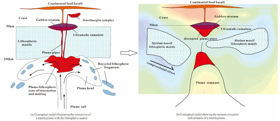
Figure 11.
Mantle plume–lithosphere interaction and subsequent tectonic evolution of the Jinchuan Cu–Ni sulfide deposit (a), modified from reference [44].
6. Conclusions
Using P-wave seismic tomography, this study reveals the velocity structure of the lithosphere beneath the southwestern margin of the North China Craton, where the Jinchuan Cu–Ni sulfide deposit is located, and identifies several prominent anomalies.
- (1)
- A shallow low-velocity anomaly trending northeast extends to ~80 km depth and gradually diffuses toward the Longshoushan continental margin, splitting into two segments: the northern part of the North Qilian suture zone and the southern segment of the Hexi Corridor arc–back-arc basin. This anomaly reflects multiple episodes of magmatic activity, interpreted as the geophysical signature of magmatism induced by the collision and subduction of the Qilian–Qaidam and Alxa blocks following the closure of the Paleozoic Qilian Ocean.
- (2)
- Beneath the shallow low-velocity anomaly, a deeper anomaly at a depth of 320–400 km spatially corresponds to the shallow anomaly. Based on the interaction between mantle plumes and the lithosphere, this deep anomaly is interpreted as a residual feature of a mantle plume, indicating that the deep mantle provided a long-term source of heat and fusible material to sustain magmatic activity beneath the deposit.
- (3)
- High-velocity anomalies flanking the North Qilian suture zone record the lithospheric structure of the Qaidam and Alxa blocks. The western anomaly, at a 80–300 km depth with a curved front, corresponds to the high-velocity, refractory lithospheric mantle of the Qaidam block, while the eastern anomaly, at a 80–240 km depth, represents the stable lithospheric mantle of the Alxa block. Following the closure of the Qilian Ocean, subduction of the Qaidam lithospheric mantle beneath the Alxa block not only supplied the driving force for regional magmatic activity but also controlled its spatial distribution, contributing to the Cenozoic tectonic evolution of the Longshoushan continental margin.
Overall, the shallow low-velocity anomaly records multiple episodes of magmatic activity that provided the heat and metal-rich material necessary for the formation of the Jinchuan Cu–Ni deposit. The deep low-velocity anomaly reflects residual mantle plume activity that maintained a sustained supply of material from the deep mantle to the lithosphere. The high-velocity anomalies on both sides controlled the spatial distribution and dynamics of magmatism. Together, these anomalies delineate the pathways of heat and material transfer from the deep mantle to the lithosphere and provide critical geophysical evidence for understanding the mechanisms of ore formation and the role of magmatic processes in supplying material to the Jinchuan Cu–Ni deposit.
Author Contributions
Methodology, J.Z.; validation, J.Z., S.D., and R.P.; formal analysis, J.Z.; investigation, J.Z.; resources, J.Z.; data curation, J.Z.; writing—original draft preparation, J.Z.; writing—review and editing, J.Z., S.D., and R.P.; supervision, S.D.; project administration, S.D.; funding acquisition, S.D. All authors have read and agreed to the published version of the manuscript.
Funding
This research was funded by Geological Survey Project of the China Geological Survey (No. DD20240117) and the National Natural Science Foundation of China (No. 42474181). The APC was funded by the Geological Survey Project of the China Geological Survey (No. DD20240117).
Institutional Review Board Statement
Not applicable.
Informed Consent Statement
Not applicable.
Data Availability Statement
The data presented in this study are available in ISC at https://doi.org/10.31905/6TJZECEY (accessed on 24 August 2025) and National Earthquake Data Center at http://data.earthquake.cn (accessed on 24 August 2025). These data were derived from the following resources available in the public domain: http://www.isc.ac.uk (accessed on 24 August 2025) and http://data.earthquake.cn (accessed on 24 August 2025).
Acknowledgments
We gratefully acknowledge Jincheng Ma and You Tian for their help with the seismic tomography. We also thank Qixing Ai and Jianquan Lu from the Jinchuan Group for their help and support. We thank the editor and anonymous reviewers for their useful comments, which greatly improved our manuscript.
Conflicts of Interest
The authors declare no conflicts of interest.
References
- Naldrett, A. Magmatic Sulfide Deposits: Geology, Geochemistry and Exploration; Springer: Berlin/Heidelberg, Germany; New York, NY, USA, 2004; pp. 1–727. [Google Scholar]
- Porter, T.M. Regional tectonics, geology, magma chamber processes and mineralisation of the Jinchuan nickel-copper-PGE deposit, Gansu Province, China: A review. Geosci. Front. 2016, 7, 431–451. [Google Scholar] [CrossRef]
- Li, W. Study of ore-forming theoretical innovation and prospecting breakthrough of magmatic copper-nickel-cobalt sulfide deposits in China. J. Geomech. 2022, 28, 793–820, (In Chinese with Abstract in English). [Google Scholar]
- Tang, Z.; Li, W. Metallogenic Model and Geological Comparison of Copper-Nickel Sulfide (Platinum-Bearing) Deposits in Jinchuan; Geological Publishing House: Beijing, China, 1995; pp. 14–209. (In Chinese) [Google Scholar]
- Chai, G.; Naldrett, A. The Jinchuan ultramafic intrusion: Cumulate of a high-Mg basaltic magma. J. Petrol. 1992, 33, 277–303. [Google Scholar] [CrossRef]
- Chai, G.; Naldrett, A. Characteristics of Ni-Cu-PGE mineralization and genesis of the Jinchuan deposit, northwest China U. Econ. Geol. 1992, 87, 1475–1495. [Google Scholar] [CrossRef]
- Song, X.Y.; Danyushevsky, L.V.; Keays, R.R.; Chen, L.M.; Wang, Y.S.; Tian, Y.L.; Xiao, J.F. Structural, lithological, and geochemical constraints on the dynamic magma plumbing system of the Jinchuan Ni-Cu sulfide deposit, NW China. Miner. Depos. 2012, 47, 277–297. [Google Scholar] [CrossRef]
- Kang, J.; Chen, L.M.; Yu, S.Y.; Zheng, W.Q.; Dai, Z.H.; Zhou, S.H.; Ai, Q.X. Chromite geochemistry of the Jinchuan Ni-Cu sulfide-bearing ultramafic intrusion (NW China) and its petrogenetic implications. Ore Geol. Rev. 2022, 141, 104644. [Google Scholar] [CrossRef]
- Mao, X.; Li, L.; Liu, Z.; Zeng, R.; Dick, J.M.; Yue, B.; Ai, Q. Multiple Magma Conduits Model of the Jinchuan Ni-Cu-(PGE)Deposit, Northwestern China: Constraints from the Geochemistry of Platinum-Group Elements. Minerals 2019, 9, 187. [Google Scholar] [CrossRef]
- Mao, X.; Liu, P.; Deng, H.; Liu, Z.; Li, L.; Wang, Y.; Ai, Q.; Liu, J. A Novel Approach to Three-Dimensional Inference and Modeling of Magma Conduits with Exploration Data: A Case Study from the Jinchuan Ni-Cu Sulfide Deposit, NW China. Nat. Resour. Res. 2023, 32, 32–901. [Google Scholar] [CrossRef]
- Su, S.; Tang, Z.; Luo, Z.; Deng, J.; Wu, G.; Zhou, M.; Song, C.; Xiao, Q. Magmatic Conduit Metallogenic System. Acta Petrol. Sin. 2014, 30, 3120–3130, (In Chinese with Abstract in English). [Google Scholar]
- Liu, M.Y.; Su, S.G.; Liu, X.R.; Guo, X.D.; Li, Y.M. Magmatic Conduit Metallogenic System of Jinchuan Cu-Ni (PGE) Sulfide Deposit: Evidence from Mineralogy. Earth Sci. Front. 2025, 32, 390–411. [Google Scholar] [CrossRef]
- Zeng, R.; Lai, J.; Mao, X. Metallogenic Model of Magma Conduit System of Jinchuan Cu-Ni Sulfide Deposit. Miner. Resour. Geol. 2013, 27, 276–282, (In Chinese with Abstract in English). [Google Scholar]
- Yang, G.; Du, A.; Lu, J.; Qu, W.; Chen, J. Re-Os (ICP-MS) dating of the massive sulfide ores from the Jinchuan Ni-Cu-PGE deposit. Sci. China Ser. D-Earth Sci. 2005, 48, 1672–1677. (In Chinese) [Google Scholar] [CrossRef]
- Tian, Y.L.; Wu, S.J.; Meng, R.; Wang, Y.S.; Lin, C.L.; Xiao, L.Z. LA-ICPMS zircon U-Pb age of the Jinchuan ultramafic intrusion. Acta Mineral. Sin. 2007, 27, 211–217, (In Chinese with Abstract in English). [Google Scholar]
- Zhang, M.; Kamo, S.L.; Li, C.; Hu, P.; Ripley, E.M. Precise U-Pb zircon-baddeleyite age of the Jinchuan sulfide ore-bearing ultramafic intrusion, Western China. Miner. Depos. 2010, 45, 3–9. [Google Scholar] [CrossRef]
- Tao, N.; Duan, J.; Danišík, M.; Jiao, J.; Dong, Y.; Evans, N.J.; Gao, Y.; Jiao, R.; Rahn, M. Paleozoic tectonothermal evolution of the Jinchuan Ni-Cu sulfide deposit, NW China: New constraints from 40Ar/39Ar and (U-Th)/He thermochronology. J. Asian Earth Sci. 2023, 250, 105622. [Google Scholar] [CrossRef]
- Yang, H.Q.; Tang, Z.L.; Su, L.; Li, W.Y.; Song, S.G.; Yang, D.J. Discussion on characters of minerogenic magma and source area in Jinchuan Cu-Ni sulfide deposit. Acta Geol. Gansu 1997, 6, 45–53, (In Chinese with Abstract in English). [Google Scholar]
- Li, X.H.; Su, L.; Chung, S.L.; Li, Z.X.; Liu, Y.; Song, B.; Liu, D.Y. Formation of the Jinchuan ultramafic intrusion and the world’s third largest Ni-Cu sulfide deposit: Associated with the∼825 Ma south China mantle plume? Geochem. Geophys. Geosyst. 2005, 6, Q11004. [Google Scholar] [CrossRef]
- Ripley, E.; Sarkar, A.; Li, C. Mineralogic and stable isotope studies of hydrothermal alteration at the Jinchuan Ni-Cu deposit, China. Econ. Geol. 2005, 100, 1349–1361. [Google Scholar] [CrossRef]
- Yang, S.; Qu, W.; Tian, Y.; Chen, J.; Yang, G.; Du, A. Origin of the inconsistent apparent Re-Os ages of the Jinchuan Ni-Cu sulfide ore deposit, China: Post-segregation diffusion of Os. Chem. Geol. 2008, 247, 401–418. [Google Scholar] [CrossRef]
- Duan, J.; Li, C.; Qian, Z.; Jiao, J.; Ripley, E.M.; Feng, Y. Multiple S isotopes, zircon Hf isotopes, whole-rock Sr-Nd isotopes, and spatial variations of PGE tenors in the Jinchuan Ni-Cu-PGE deposit, NW China. Miner. Depos. 2016, 51, 557–574. [Google Scholar] [CrossRef]
- Zhao, Y.; Liu, S.A.; Xue, C.; Li, M.L. Copper isotope evidence for a Cu-rich mantle source of the world-class Jinchuan magmatic Ni-Cu deposit. Am. Mineral. 2022, 107, 673–683. [Google Scholar] [CrossRef]
- Zhang, C.L.; Yang, D.S.; Wang, H.Y.; Takahashi, Y.; Ye, H.M. Neoproterozoic mafic-ultramafic layered intrusion in Quruqtagh of northeastern Tarim Block, NW China: Two phases of mafic igneous activity with different mantle sources. Gondwana Res. 2011, 19, 177–190. [Google Scholar] [CrossRef]
- Piraino, F. The Geology and Tectonic Settings of China’s Mineral Deposits; Springer: Dordrecht, The Netherlands, 2013; 679p. [Google Scholar]
- Tang, Z.; Bai, Y.; Li, W.; Xu, H.Z.; Li, F.Q.; Yan, H.Q.; Huang, C.X.; Wang, Z. Metallogenic System and Metallogenic Structure Dynamics on the Southwestern Margin of the North China Paleocontinent (Longshou Mountain-Qilian Mountain); Geological Publishing House: Beijing, China, 2002; 393p. (In Chinese) [Google Scholar]
- Li, C.; Ripley, E.M. The giant Jinchuan Ni-Cu(PGE) deposit tectonic setting, magma evolution, ore genesis, and exploration implications. Rev. Econ. Geol. 2011, 17, 163–180. [Google Scholar]
- Song, S.; Zhang, L.; Niu, Y.; Su, L.; Song, B.; Liu, D. Evolution from oceanic subduction to continental collision: A case study from the northern Tibetan Plateau based on geochemical and geochronological data. J. Petrol. 2006, 47, 435–455. [Google Scholar] [CrossRef]
- Barnes, S.J.; Tang, Z. Chrome spinels from the Jinchuan Ni-Cu sulfide Deposit, Gansu Province, Peoples’ Republic of China. Econ. Geol. 1999, 94, 343–356. [Google Scholar] [CrossRef]
- Tang, Z.; Qian, Z.; Jiang, C. Ni-Cu-PGE Magmatic Sulfide Metallogeny and Deposit Prediction in China; Geological Publishing House: Beijing, China, 2006. (In Chinese) [Google Scholar]
- French, S.W.; Romanowicz, B. Broad plumes rooted at the base of the Earth’s mantle beneath major hotspots. Nat. Geosci. 2015, 8, 75–81. [Google Scholar] [CrossRef] [PubMed]
- Garnero, E.J.; McNamara, A.K.; Shim, S.H. Continent-sized anomalous zones with low seismic velocity at the base of Earth’s mantle. Nat. Rev. Earth Environ. 2020, 1, 39–54. [Google Scholar] [CrossRef]
- Zhang, Y.; Zhang, F.; Zhang, X.; Zhang, T.; Lin, J.; Zhou, Z.; Zhang, J. Modification of Along-Ridge Topography and Crustal Structure by Mantle Plumes Beneath Mid-Ocean Ridges. Geophys. Res. Lett. 2023, 50, e2023GL105871. [Google Scholar] [CrossRef]
- Zhao, D.; Hasegawa, A.; Kanamori, H. Deep structure of Japan subduction zone as derived from local, regional, and teleseismic events. J. Geophys. Res. Solid Earth 1994, 99, 22313–22329. [Google Scholar] [CrossRef]
- Zhao, D.; Tian, Y.; Lei, J.; Liu, L.; Zheng, S. Seismic image and origin of the Changbai intraplate volcano in East Asia: Role of big mantle wedge above the stagnant Pacific slab. Phys. Earth Planet. Inter. 2009, 173, 197–206. [Google Scholar] [CrossRef]
- Jiang, G.; Zhang, G.; Lü, Q.; Shi, D.; Xu, Y. 3-D velocity model beneath the Middle-LowerYangtze River and its implication to the deep geodynamics. Tectonophysics 2013, 606, 36–47. [Google Scholar] [CrossRef]
- Zhao, D.; Hasegawa, A.; Horiuchi, S. Tomographic imaging of P and S wave velocity structure beneath northeastern Japan. J. Geophys. Res. Solid Earth 1992, 97, 19909–19928. [Google Scholar] [CrossRef]
- Um, J.; Thurber, C. A fast algorithm for two-point seismic ray tracing. Bull. Seismol. Soc. Am. 1987, 77, 972–986. [Google Scholar] [CrossRef]
- Wessel, P.; Smith, W.H.F. New, improved version of GenericMapping Tools released. EOS 1998, 79, 579. [Google Scholar] [CrossRef]
- Tang, Z.; Bai, Y. Geotectonic framework and metallogenic system in the southwest margin of north China paleocontinent. Earth Sci. Front. 1999, 6, 78–90, (In Chinese with Abstract in English). [Google Scholar]
- Zhang, K. Paleozoic Magma Evolution and Super Imposed Mineralization in the Jinchuan Cu-Ni Mining Area of Gansu Province. Master’s Thesis, Chang’an University, Xi’an, China, 2023. (In Chinese with Abstract in English). [Google Scholar]
- Xia, L.; Li, X.; Yu, J.; Wang, G. Mid-Late Neoproterozoic to Early Paleozoic volcanism and tectonic evolution of the Qilian Mountain. Geol. China 2016, 43, 1087–1138, (In Chinese with Abstract in English). [Google Scholar]
- Zhang, X.; Su, S.; Liu, M.; Wang, W. Characteristics and tectonic significance of the early Paleozoic syenite granite from Jinchuan Gansu Province. Earth Sci. Front. 2021, 28, 283–298. [Google Scholar]
- Piraino, F. Ore Deposits and Mantle Plumes; Kluwer Academic Publishers: London, UK, 2000; pp. 1–540. [Google Scholar]
Disclaimer/Publisher’s Note: The statements, opinions and data contained in all publications are solely those of the individual author(s) and contributor(s) and not of MDPI and/or the editor(s). MDPI and/or the editor(s) disclaim responsibility for any injury to people or property resulting from any ideas, methods, instructions or products referred to in the content. |
© 2025 by the authors. Licensee MDPI, Basel, Switzerland. This article is an open access article distributed under the terms and conditions of the Creative Commons Attribution (CC BY) license (https://creativecommons.org/licenses/by/4.0/).