Article

Paleogene Geomorphy and Formation Process of the Diaoyu Islands Folded-Uplift Belt, East China Sea Basin: Insights of the Dynamics of Subducting Slab on the Control of Tectonic Evolution in Back-Arc Basins

1
School of Ocean Sciences, China University of Geosciences (Beijing), Beijing 100083, China
2
Key Laboratory of Polar Geology and Marine Mineral Resources, China University of Geosciences (Beijing), Ministry of Education, Beijing 100083, China
3
China National Offshore Oil Corporation (CNOOC) China Limited (Shanghai), Shanghai 200335, China
*
Author to whom correspondence should be addressed.
Appl. Sci. 2025, 15(16), 8878; https://doi.org/10.3390/app15168878
Submission received: 18 June 2025 / Revised: 1 August 2025 / Accepted: 7 August 2025 / Published: 12 August 2025
(This article belongs to the Special Issue Advances in Seismic Sedimentology and Geomorphology)

Abstract

The Diaoyu Islands Folded-Uplift Belt consists of metamorphic basement, magmatic rocks and Paleogene series in the Eastern Depression Zone of the East China Sea Basin which was deformed and uplifted by magma emplacement. The emplacement of the magma resulted in an unclear understanding of the Paleogene geomorphy in the paleo-uplift, further affecting the analysis of the eastern boundary and the sedimentary environment of Paleogene prototype basin in the Eastern Depression Zone. To explore the Paleogene geomorphy and magma emplacement process of the Diaoyu Islands Folded-Uplift Belt, we conducted a detailed interpretation of 2-D seismic profiles and identified nearshore subaqueous fans and fan deltas within the deformed strata. The development scale of them helps to determine the approximate location of the Paleogene eastern boundary of the Eastern Depression Zone. We integrated the boundary location with gravity, magnetic, and well data to obtain the Paleogene geomorphy of the Diaoyu Islands Folded-Uplift Belt. Our results indicate that the subduction direction of the Pacific Plate was almost perpendicular to the Eurasian Plate during the late Eocene, leading to the development of numerous left-lateral strike-slip faults within the East China Sea Basin, further forming channels within the paleo-uplift, which connected the Eastern Depression Zone and the ocean. In the Early Oligocene, the subduction rate of the Pacific Plate abruptly increased, resulting in large-scale and significant exhumation of the paleo-uplift, and the Eastern Depression Zone had transformed into a lacustrine sedimentary environment. Furthermore, due to the continuous retreat of the Pacific Plate, the extension center of the back-arc basin moved to the eastern margin of the Eastern Depression Zone in the late Oligocene. This work provides a method for recovering the geomorphology of complex tectonic units in back-arc basins based on fine seismic interpretation, solving the key problem that constrained the recovery of boundaries and sedimentary environment of the prototype basin.

1. Introduction

In recent years, the recovery of prototype basins has gradually become a research highlight in the field of basins, as it can provide insights into the original conditions/features of basins in geologic history, including paleogeography, sedimentary systems, paleoclimate and paleoenvironment, and regional tectonic background [1,2,3,4,5]. In the process of recovery the paleogeography of the prototype basin, it is necessary to analyze the boundaries of the prototype basin, the location of uplift areas [5], the provenance information, the sediment routing [6], the sedimentary environment [7], and the effect of salt or magma [8]. The emplacement/diapirism of viscous substances such as magma, salt, and clay often deforms the paleogeomorphy of the prototype basin, making recovery of the prototype basin difficult [9,10,11,12,13]. Recovering basin boundaries is a crucial step in recovering the prototype basin [14,15]. The boundaries of rifted basins are usually deep faults that extend into the basement, providing ample space for the emplacement of deep, viscous substances. The occurrence of such geological events can make the prototype basin boundary invisible, hindering our further analysis of the prototype basin [3,8,16].
The Diaoyu Islands Folded-Uplift Belt (DIFUB) which is also named the Taiwan-Sinzi Belt, is located in the central part of the East China Sea Basin, separating the East China Sea Shelf Basin from the Okinawa Trough [17,18,19]. Unlike other paleo-uplifts in the basin, the DIFUB is not solely composed of metamorphic basement; it also includes the eastern strata of the prototype basin in the Eastern Depression Zone, which was uplifted by late-stage magmatic emplacement [18,19,20]. Prior to the Miocene rifting, the metamorphic basement of the DIFUB was connected to the eastward spreading Dragon King Uplift Belt and the Ryukyu Uplift, collectively known as the East China Sea Shelf Outer Margin Uplift (ECSSOMU) [18,21,22] (Figure 1). Since the formation of the Eastern Depression Zone, the ECSSOMU, as an uplift on the eastern side of the Eastern Depression Zone, has separated it from the ocean and controlled the sedimentary environment of the Eastern Depression Zone [22,23,24]. Therefore, clarifying Paleogene geomorphy of the DIFUB will help us gain a new understanding of the sedimentary environment of Paleogene prototype basin in the Eastern Depression Zone, and further understand how the tectonic characteristics of back-arc basins respond to plate tectonics.
Due to the lack of well and 3D seismic data, as well as the complexity of DIFUB lithology, lithofacies and structural styles, previous works on the formation and evolution of the DIFUB are relatively less advanced compared to other areas of the East China Sea Basin. Furthermore, there is a significant lack of work into the dynamic mechanisms driving its formation and evolution. It was generally believed that the metamorphic basement of the DIFUB possesses a Precambrian metamorphic crystalline basement, similar to the Central Uplift Zone [19,21]. Before the formation of the Eastern Depression Zone, ECSSOMU was connected to the Central Uplift Zone [24,25] (Figure 1). The evolution of the DIFUB shows significant north–south differences, including exhumation history [24], deformation of the eastern part of the prototype basin in the Eastern Depression Zone by late-stage magma emplacement [19], the effect of the subduction of the Philippine Sea Plate towards the eastern margin of the Eurasian Plate since the Miocene [26]. Wang et al. [22] judged that the ECSSOMU formed during the Late Jurassic–Early Cretaceous, with continuous uplift on the west side and continuous accretion on the east side. Jiang et al. [19] has found that there are Paleogene series traversing the entire DIFUB, which may be channels connecting the Eastern Depression Zone with the ocean. Gungor et al. [18] showed that the subduction of the Philippine Sea Plate caused the rifting of the ECSSOMU, forming the present-day independent tectonic unit (Figure 1).
Here, we use 2-D seismic, gravity, magnetic and well data from the East China Sea Basin, to investigate the lithology combination and structural styles of the DIFUB. The aims of this work are as follows: (a) to determine the location of the eastern boundary of the prototype basin in the Eastern Depression Zone which destroyed due to magma emplacement; (b) to investigate Paleogene geomorphy of the DIFUB; and (c) to discuss the formation process of the DIFUB in response to plate tectonics. Through the analysis of the DIFUB, we anticipate that our method will provide insights for the recovery of prototype basin, and our results will offer new understanding of the influence of the dynamics of subducting slab on the control of tectonic evolution in back-arc basins.

2. Geological Setting

The East China Sea Basin is located at the eastern margin of the Eurasian Plate and covers an area of approximately 2.4 × 10⁵ km2 [24,25,27] (Figure 2a). It is a Mesozoic–Cenozoic superimposed basin, meaning that during the Mesozoic, the East China Sea Basin was a fore-arc basin, and a back-arc basin developed on top of it during the Cenozoic [25,28]. The basin generally trends NNE, with two major fault sets trending NNE and NW [20,27]. From west to east, the East China Sea Basin can be divided into the Western Depression Zone, the Central Uplift Zone, the Eastern Depression Zone, the DIFUB, and the Okinawa Trough [23,29]. The Western Depression Zone is further divided into the Kunshan Sag, Changshu Low Uplift, Jinshan Sag, Qiantang Sag, Fuzhou Sag and Lishui-Jiaojiang Sag; the Eastern Depression Zone is further divided into the Fujiang Sag, Xihu Sag, and Diaobei Sag (Figure 2b).
The DIFUB extends approximately 1045 km north–south and its area is approximately 4.6 × 10⁴ km2 [22]. The DIFUB can be divided into a north-central part and a southern part by the Yushan-Kume Fault Belt. The north-central part is the main body, trending NNE; the southern part trends NE, further turning to NEE via the Miyako Fault Belt [20,30] (Figure 2b). Late-stage magmatism deformed and uplifted the strata on the eastern part of the Eastern Depression Zone. These magmatic rocks and uplifted strata, along with the Diaoyu Islands paleo-uplift on the western side, formed the DIFUB [18,19,22] (Figure 2c,d). The deformed and uplifted strata include the Baoshi Formation, Pinghu Formation, and Huagang Formation, which developed from the Middle Eocene to the Oligocene (Figure 2c,d). During the magma emplacement process, the eastern boundary of the prototype basin in the eastern depression zone disappeared completely due to being filled with magma. During the Pliocene, the DIFUB began to subside and receive widespread sedimentation [18].

2.1. Mesozoic Tectonic Evolution

The East China Sea Basin was controlled by the circum-Pacific tectonic domain and the Mongol-Okhotsk tectonic domain during the Mesozoic. Its development location corresponds to the present-day Western Depression Zone and Central Uplift Zone, represented by the Fuzhou Sag, developing lacustrine sedimentary environment [25]. At the Triassic–Jurassic boundary, the Izanagi Plate began to subduct at a low angle beneath the Eurasian Plate [29,31]. The Mesozoic volcanic arc roughly located in the present-day Minzhe Uplift and the Western Depression Zone [32]. The forearc area was flexed by the subduction process, forming a forearc basin [33,34].

2.2. Cenozoic Tectonic Evolution

In the Late Cretaceous, the Mongol-Okhotsk tectonic domain transitioned to an extensional setting, while the Neo-Tethys Ocean to the south of the Eurasian Plate rapidly closed. The East China Sea Basin was controlled by both the circum-Pacific and Neo-Tethys tectonic domains, and the Western Depression Zone began rifting [24,29]. The mid-ocean ridge between the Izanagi Plate and Pacific Plate began subducting in the Late Cretaceous, transitioning to the Pacific Plate subduction beneath the Eurasian Plate in the Middle Paleocene [29,31]. In the Middle Eocene, with the retreat of the Pacific Plate, the extensional center of the East China Sea Basin jumped eastward, and Eastern Depression Zone began rifting [35] (Figure 3). During the Early Miocene, the Philippine Sea Plate began to subduct beneath the Eurasian Plate along several key segments of its northern and western boundaries [36]. In the Late Miocene, the extensional center continued to migrate eastward, and the ECSSOMU gradually rifted from north to south, forming the Okinawa Trough [18].

3. Data Sets and Methods

3.1. Data Sets

The 2-D seismic, gravity, magnetic and well data used in this work were provided by the Shanghai Branch of China National Offshore Oil Corporation. The data presented in the article have been approved, and the rest of data cannot be provided due to commercial confidentiality.
The 2-D seismic lines cover an area extending eastward from the Western Depression Zone to the DIFUB, and partly into the Okinawa Trough, and from south to north, from the northern part of the Diaobei Sag to the Xihu Sag. The spacing between seismic lines ranges from 2 to 20 km, with a total length exceeding 4000 km.
The gravity and magnetic data were gridded to 1 km × 1 km spacing and compiled as maps of Bouguer gravity anomalies and the RTP (reduction to the pole) magnetic anomalies, respectively.
The wells are located at the western part of the Xihu Sag, including mud logging, geochemical, and paleontological data.

3.2. Determining the Eastern Boundary of the Paleogene Prototype Basin in the Eastern Depression Zone

The key to determining the location of the prototype basin boundary is to explore alluvial fans or nearshore subaqueous fans or fan deltas [38,39,40,41]. In this work, we conducted a detailed interpretation of the seismic reflection characteristics in the strata deformed and uplifted by magma diapirism, and explored the seismic facies that can respectively characterize alluvial fans, nearshore subaqueous fans, and fan deltas. By analyzing the development characteristics and scale after erosion of the seismic facies and inferring the complete development scale of the seismic facies, the location of the basin boundary can be roughly determined.
Meanwhile, the lithological combination of the DIFUB includes the paleo-uplift (metamorphic basement), magmatic rocks, and deformed strata (sedimentary rocks). These three lithologies can be distinguished by gravity and magnetic anomalies. Gravity anomalies are caused by density differences between rocks, with intrusive rocks > metamorphic rocks > extrusive rocks > sedimentary rocks. Analysis of gravity anomalies allows for the differentiation between the Diaoyu Islands paleo-uplift and the deformed strata. Magnetic anomalies are caused by differences in remanent magnetic intensity. Magmatic rocks are strongly magnetic, metamorphic rocks exhibit widely varying remanent magnetic intensity, and sedimentary rocks are generally non-magnetic or weakly magnetic. Analysis of magnetic anomalies can identify the distribution of magmatic rocks.
We use multiple 2-D seismic profiles crossing the DIFUB. Based on the identification of the eastern seismic facies of the prototype basin in the Xihu Sag, the locations of the seismic facies on each 2-D seismic profile were projected onto the maps of Bouguer gravity anomalies and the RTP magnetic anomalies. Combining the lithological differences determined by gravity and magnetic anomalies, we comprehensively characterized the location of the eastern boundary of the prototype basin in the Xihu Sag and the geomorphy of the Diaoyu Islands paleo-uplift.

4. Results

4.1. Identification of Seismic Facies at the Eastern Margin of the Paleogene Prototype Basin in the Xihu Sag

This work identifies three types of Paleogene seismic facies developed at the eastern margin of the Paleogene prototype basin in the Xihu Sag. The following sections focus on the seismic reflections of these seismic facies, providing information for the interpretation of sedimentary facies.
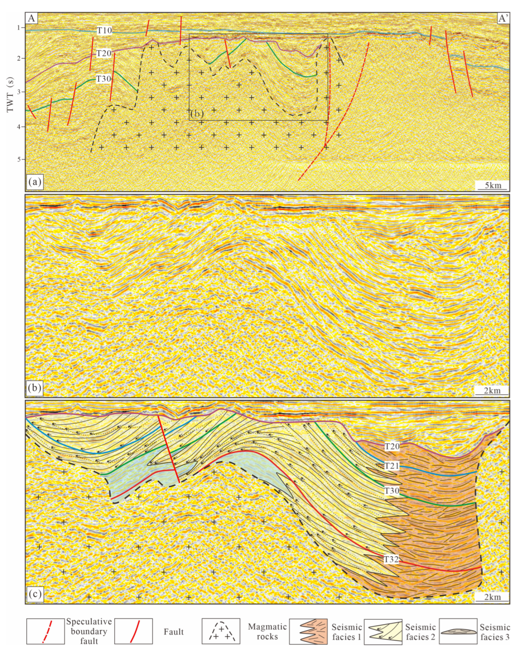
Seismic facies 1: characterized by medium-to-high amplitude, moderate continuity, chaotic reflection patterns, and chaotic progradational reflection configurations with a cone-shaped external form. Seismic facies 1 developed within the Eocene and Oligocene Series in the easternmost margin of the prototype basin in the Xihu Sag, but was partially destroyed by magma (Figure 4c, Figure 5b and Figure 6c).
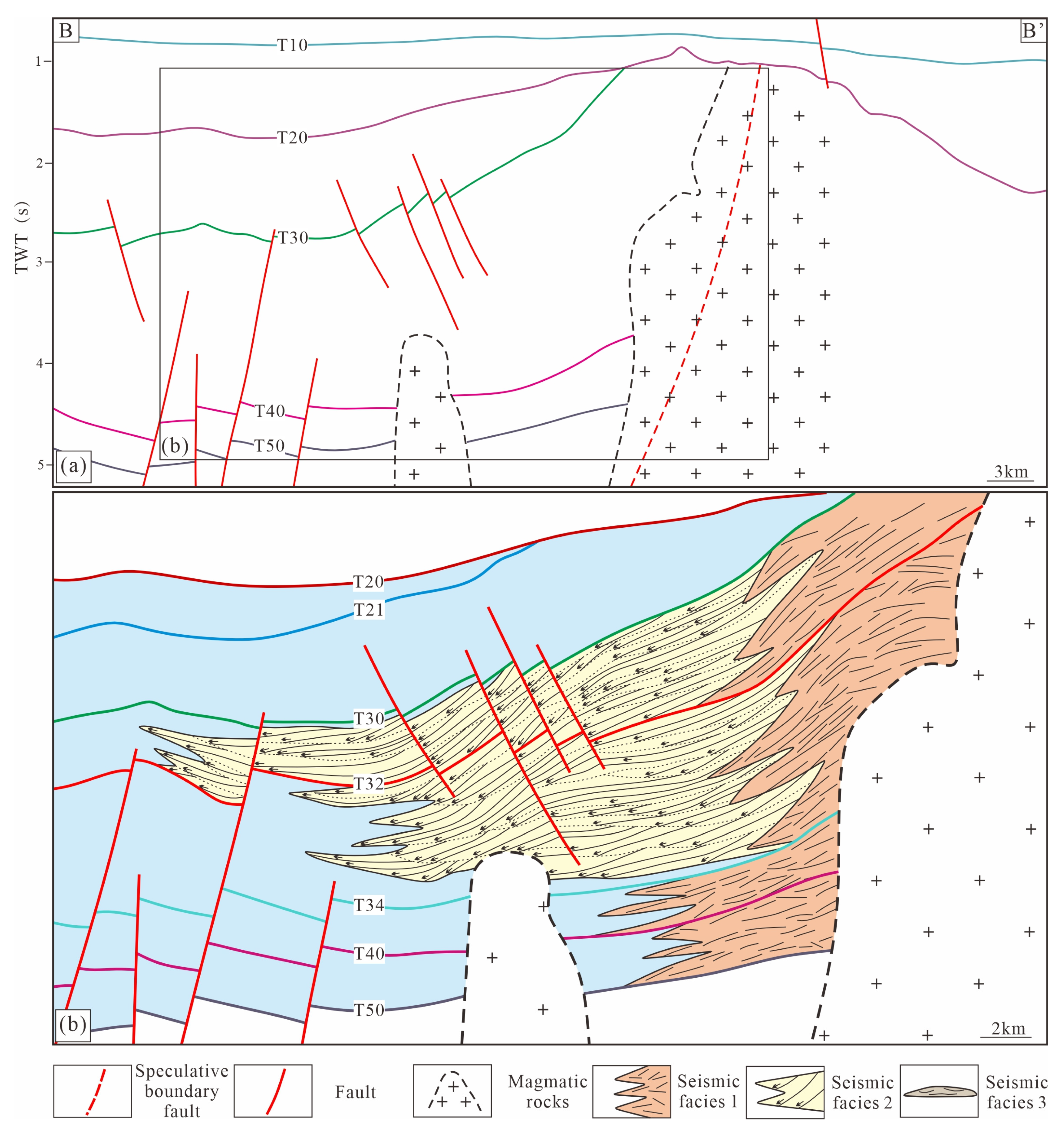
Seismic facies 1 in the Baoshi Formation and the Lower Pinghu Formation may represent nearshore subaqueous fan deposits, which is comprised of coarse grained sandstones or glutenite. These seismic facies are considered products of high-density, high-energy gravity flows. The seismic facies west of seismic facies 1 in the Baoshi Formation exhibits low-to-medium amplitude, poor continuity, wavy or chaotic reflection configurations, lacking the characteristics of progradational reflection configurations. This corresponds to the widespread development of thick deep-water mudstone facies in the Baoshi Formation (Figure 3). Lateral variations in amplitude and continuity are not observable in seismic facies 1; therefore, it is inferred that the late-stage magma emplacement resulted in the absence of the fan root subfacies. It left only the fan middle and fan side subfacies, with a developed scale of approximately 5–8 km. The inferred scale of the complete nearshore subaqueous fans is 7–12 km, meaning the boundary fault of the prototype basin is located approximately 2–4 km east of seismic facies 1 (Figure 5a).
Seismic facies 2: characterized by low-to-medium amplitude, poor continuity, toplap, oblique and inverse sigmoid progradational reflection configurations, with missing topsets and a cone-shaped external form. Seismic facies 2 is developed within the Upper-Middle Pinghu Formation and the Huagang Formation, to the west of seismic facies 1 (Figure 4c, Figure 5b and Figure 6c).
Adjacent seismic facies 1 and seismic facies 2 in the Upper-Middle Pinghu Formation and the Huagang Formation, may represent fan delta deposits. Seismic facies 2 is interpreted as fan delta front subfacies due to its prominent progradational seismic reflection configurations, which is comprised of medium-fine grained sandstone, siltstone and silty mudstone, and seismic facies 1 is interpreted as fan delta plain subfacies due to its chaotic progradational reflection configurations, which is comprised of coarse grained sandstones or glutenite. The fan delta front subfacies was well preserved in the central and southern parts of the Xihu Sag, while the fan delta plain subfacies was generally eroded. The well-preserved fan delta front subfacies extends approximately 10–24 km, while the remaining fan delta plain subfacies extends about 4–8 km. It is inferred that complete fan delta plain subfacies extends about 6–10 km, meaning the boundary fault of the prototype basin is located approximately 2 km east of remaining fan delta plain subfacies (Figure 4c, Figure 5b and Figure 6c).
Seismic facies 3: characterized by low-to-medium amplitude, poor continuity, chaotic reflection patterns with a fan or lens external form (Figure 6c). Seismic facies 3 developed within the Paleogene Series in the interior of the basin. The seismic reflection characteristics surrounding seismic facies 3 are medium-to-high amplitude, medium-to-high frequency, good continuity, parallel and sub-parallel reflection configurations.
Seismic facies 3 may represent deep-water fan deposits, which is comprised of mudstone and massive sandstone. The seismic reflections surrounding seismic facies 3 have parallel and sub-parallel reflection configurations, representing stable deep-water deposition near the basin center. Seismic facies 3 is interpreted as a gravity flow deposit resulting from the collapse of a nearshore subaqueous fan or fan delta on the eastern side into the basin interior (Figure 6c).
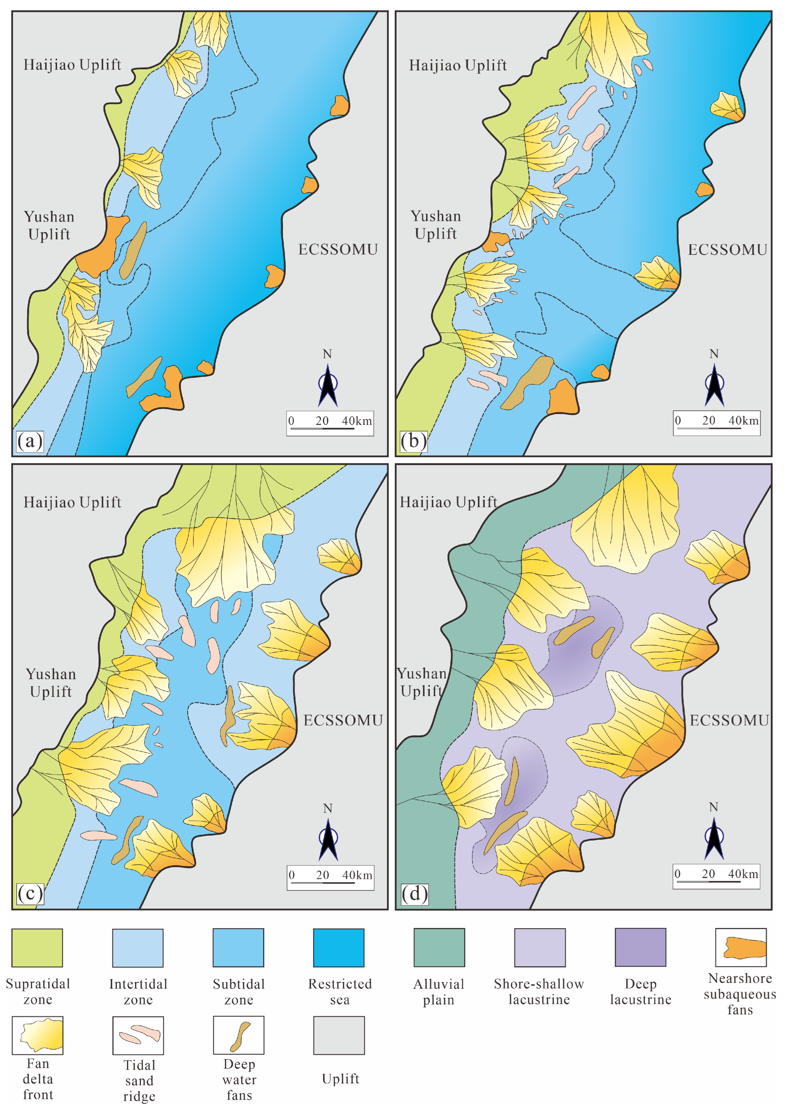
Based on the analysis of seismic facies and sedimentary facies, the plane distribution of sedimentary facies of the prototype basin during each Paleogene deposition period was mapped (Figure 7). Connecting the inferred basin boundary fault location from each 2-D seismic profile reveals the approximate features of the eastern boundary of the prototype basin during various periods.

4.2. Proposal of the Eastern Boundary of the Paleogene Prototype Basin in the Xihu Sag and the Paleogene Geomorphy of the DIFUB

4.2.1. Gravity Anomalies, Magnetic Anomalies, and Basin Boundary Proposal

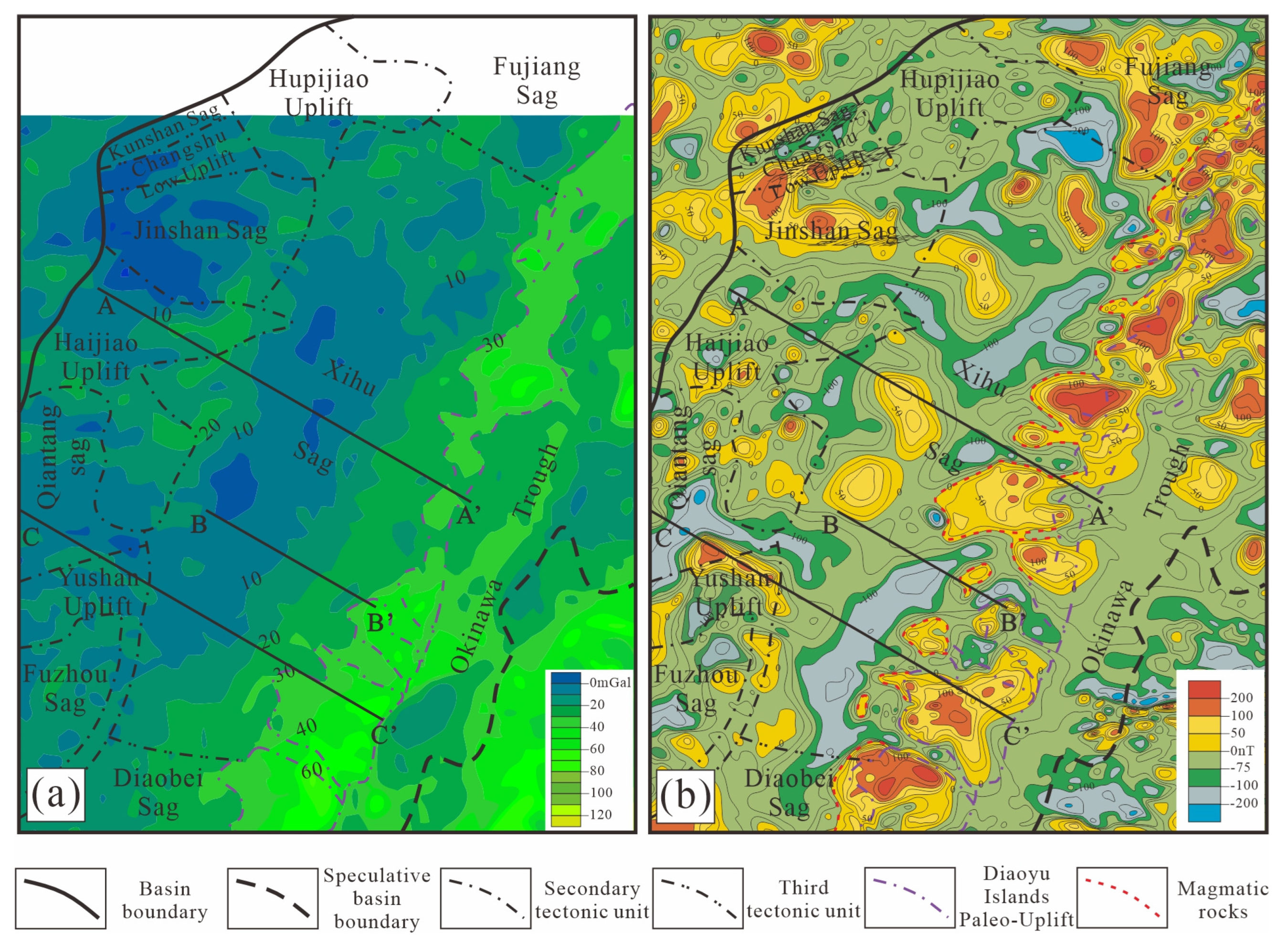
The eastern boundary of the Xihu Sag, determined by identifying Oligocene fan deltas from multiple 2-D seismic profiles, projects onto the map of Bouguer gravity anomalies, where the Bouguer gravity anomalies roughly correspond to the 30 mGal line (Figure 8a). The area east of the 30 mGal line are high anomaly zones, representing a metamorphic basement; the area west of the line are low anomaly zones, representing the Xihu Sag.
Affected by the strongly remanent magnetic intensity of magmatic rocks, when the eastern boundary of the prototype basin is projected onto the map of the RTP magnetic anomalies, there is no significant difference in magnetic anomalies on both sides (Figure 8b). Within the positive magnetic anomaly zones representing magmatic and metamorphic rocks on the east side of the eastern boundary of the Xihu Sag, there are narrow, strip-like negative magnetic anomaly zones, with minimum values reaching −260 nT, indicating the sedimentary distribution (Figure 8b). These are narrow negative magnetic anomaly zones developed in ECSSOMU, which may represent channels developed during a certain sedimentary period, allowing seawater to enter the Xihu Sag.

4.2.2. Comprehensive Analysis of the Paleogene Geomorphy of the Diaoyu Islands Paleo-Uplift

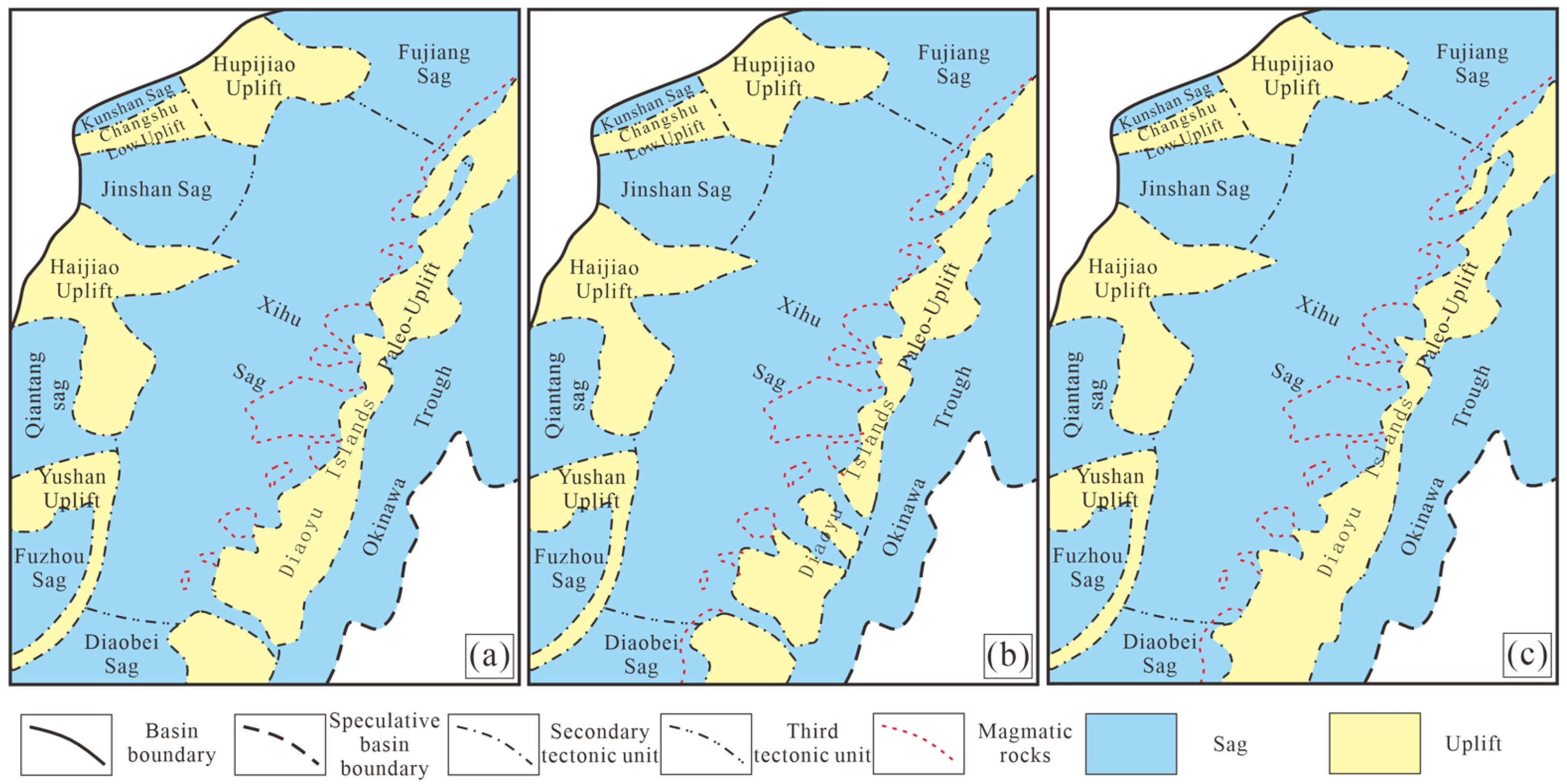
By comprehensively analyzing the distribution of sedimentary facies in various deposition periods to confirm the eastern boundary of the basin (Figure 7) and the Oligocene geomorphy of the Diaoyu Islands paleo-uplift delineated by Bouguer gravity anomalies (Figure 8a), the geomorphy of the Diaoyu Islands paleo-uplift in various periods can be roughly obtained (Figure 9). The channels connecting the Xihu Sag and the ocean are delineated based on the banded negative magnetic anomaly zones in the map of the RTP magnetic anomalies (Figure 8b). The development periods of these channels will be discussed in detail in Section 5.2.

4.3. Magmatic Rocks Within the DIFUB

The Upper Huagang Formation and underlying strata at the eastern margin of the prototype basin have been deformed and uplifted by magma diapirism. The volcanic magma conduits and deformed strata were truncated by the T20 seismic surface, indicating that the magmatic activity occurred before the formation of the T20 seismic surface, indicating that the magmatic activity occurred in the Late Oligocene (Figure 4c, Figure 5b and Figure 6c).
In the map of the RTP magnetic anomalies, the positive magnetic anomaly zones west of the Diaoyu Islands paleo-uplift represent the distribution range of magmatic rocks of this period (Figure 8b). The western boundary of these positive magnetic anomaly zones roughly corresponds to the western boundary of the present-day DIFUB. The distribution range of magmatism in the northern part of Xihu Sag is far greater than that in the southern part (Figure 8b).

5. Discussion

5.1. Formation and Evolution of the DIFUB

5.1.1. Exhumation of the ECSSOMU and Formation of the Paleogene Prototype Basin in the Eastern Depression Zone

The Yuli-Sanbagawa suture zone exists from southwest Japan to the east side of the Central Range of Taiwan, and the ECSSOMU belongs to the suture zone [42]. This suture zone is an accretionary wedge formed by the subduction of the Izanagi Plate towards the eastern margin of the Eurasian Plate from the Early Jurassic to the Late Cretaceous [29,43,44] (Figure 10A,a). In the Late Jurassic, the subduction of Izanagi Plate transitioned from low-angle to high-angle, leading to continuous retreat of the subducting slab [29,31,45] (Figure 10B). The retreat of the subducting slab caused the eastward shift of the location of compressional orogeny in the forearc, further leading to the exhumation of the western part of the ECSSOMU (namely the Diaoyu Islands paleo-uplift).
With the retreat of the Pacific Plate, the extensional center moved eastward, and the ECSSOMU and the Central Uplift Zone rifted apart in the Middle Eocene, forming the Eastern Depression Zone [25,46] (Figure 10D,d). The Paleogene prototype basin structure of the Eastern Depression Zone to be a dustpan-shaped depression, faulting in the east and overlapped in the west, with large boundary faults penetrating the basement [46,47]. East of the large boundary faults is the ECSSOMU, which separated the depression from the ocean [19,24] (Figure 10D,d) and provided detrital material for the Eastern Depression Zone, forming nearshore subaqueous fans and fan deltas to the west of the boundary fault (Figure 4c, Figure 5b and Figure 6c). Since the formation of the Eastern Depression Zone, the ECSSOMU has influenced the sedimentary system of the depression over the long term, which will be discussed in detail in Section 5.2.

5.1.2. Magmatic Deformation of the Eastern Margin of the Prototype Basin in the Eastern Depression Zone

The fault system developed in the eastern part of the prototype basin provided channels for magma emplacement. The structural style of the fault system controlled the distribution of magmatism in the end of the Late Oligocene. The Zhoushan-Guotou Fault Belt divides the Xihu Sag into two parts: the northeastern part exhibits a structural style of west dipping faulted terraces (Figure 11a), while the southeastern part shows a style of east dipping [48] (Figure 11b). After magmatic activity, the northeastern margin shows strong and widespread deformation (Figure 11a), while the southeastern margin only shows whole changes in attitude of strata near the boundary fault (Figure 11b).
Due to a lack of well from the DIFUB and the eastern margin of the Eastern Depression Zone, research on the formation mechanism of this magmatism lacks direct evidence. However, comparative works can still be conducted using magmatic rocks in other areas of the East China Sea Basin. The tectonic setting of the Cenozoic Basin in the East China Sea is that of a back-arc basin. Bimodal volcanic rock, especially basalts representing oceanic crust components, should be developed within the basin. However, the Cenozoic Basin in the East China Sea is characterized by the development of andesite [32,49]. Andesite (75 Ma) and tuff (70.42 Ma) were discovered in the Western Depression Zone, while andesite (56.5 ± 1.4 Ma, 54.1 ± 1.9 Ma, 42.5 Ma) and tuff (53.1 ± 1.6 Ma, 45.9 Ma) were discovered in the Eastern Depression Zone [32,49]. The ages of andesites in the various sag of the basin are highly consistent with the basin rifting and exhibit a progressively younger trend eastward [32,49]. Zhang et al. [50] reported the development of andesite within the Okinawa Trough, which is currently in rifting, and attributed its formation to the differentiation of basaltic magma and frequent mixing between granitic and basaltic magma.
In summary, the Cenozoic Basin in the East China Sea experienced episodic eastward jumps of the extensional center as the subducting slab continuously retreated. The extensional processes thinned the lithosphere, providing space for magma ascension. Toward the end of the Late Oligocene, the extensional center shifted eastward to the eastern margin of the prototype basin in the Eastern Depression Zone. Magma emplaced along structurally weak zones, causing deformation, uplift, and partial erosion of the Paleogene series in the eastern depression zone (Figure 10E).

5.1.3. The Influence of the Philippine Sea Plate on the Late-Stage Evolution of the DIFUB

Around 25–20 Ma, the Philippine Sea Plate subducts towards the Eurasian Plate, and the subduction rate of the Philippine Sea is greater than that of the Pacific Plate. Rapid subduction leads to strong compression of the front edge of the Eurasian Plate, resulting in a strong uplift of ECSSOMU in the Early Miocene [36].
In the Middle Miocene, the Philippine Sea Plate continued to retreat, and the extension center of the East China Sea Basin shifted eastward. The ECSSOMU began to rift, and the DIFUB separated, entering an independent evolutionary stage [18] (Figure 10F,f). The westward spreading of the DIFUB strongly compressed the Xihu Sag, resulting in the formation of Central Inversion Belt within the sag [18,51].
In the Late Miocene, the Okinawa Trough gradually opened from north to south, further separating the ECSSOMU into the Ryukyu Uplift and the Dragon King Uplift Belt (Figure 10G,g). Meanwhile, regional subsidence occurred in the East China Sea Basin, and the partial areas of the DIFUB began to receive deposits [20,51] (Figure 4c, Figure 5b and Figure 6c).

5.2. The Influence of the ECSSOMU on the Sedimentary System of the East China Sea Basin

Since the Middle Eocene, the ECSSOMU has separated from the Central Uplift Zone, and the Eastern Depression Zone has completely opened. The ECSSOMU began to strongly influence the sedimentary system of the Eastern Depression Zone. On the one hand, it controlled the connection between the basin and the ocean, while on the other hand, it underwent erosion and provided provenance to the eastern part of the Eastern Depression Zone [19,21,24]. This work takes the Xihu Sag as an example to discuss the influence of the ECSSOMU on the sedimentary system of the Eastern Depression Zone.

5.2.1. Middle Eocene

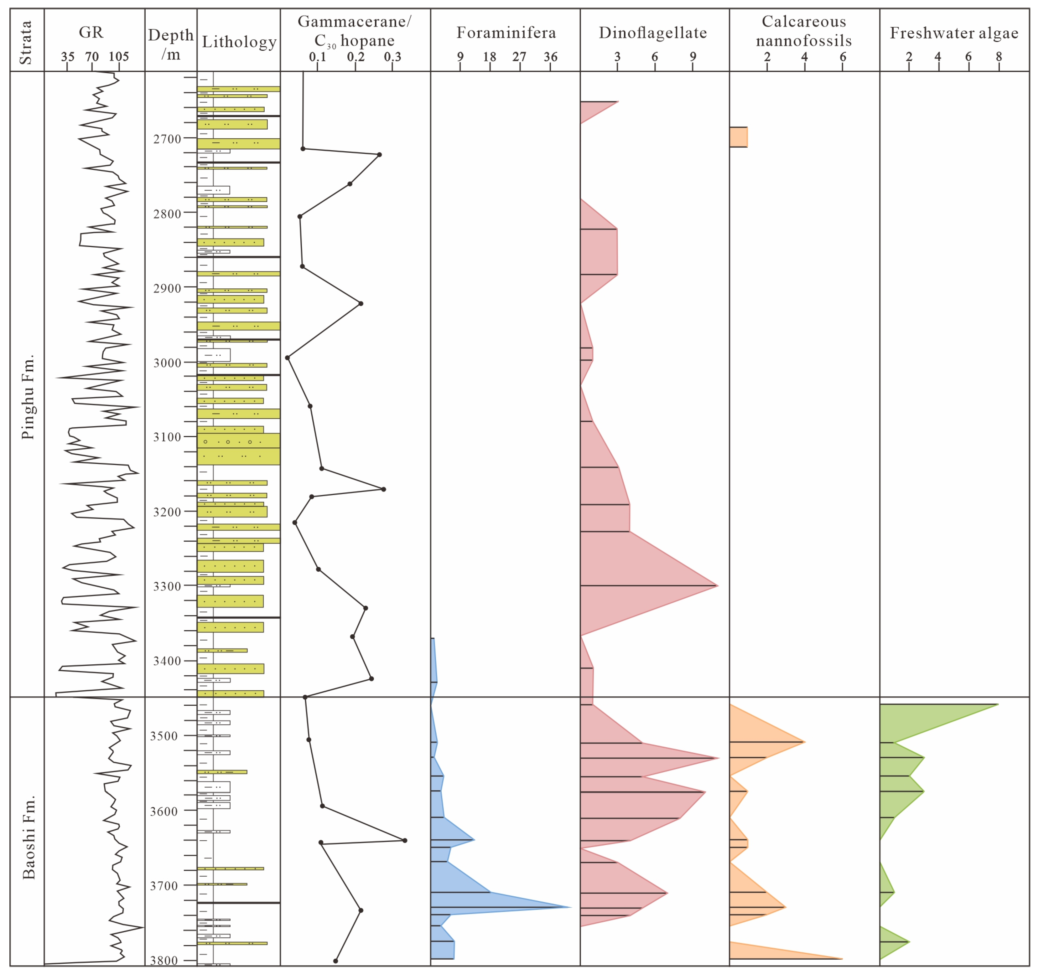
The widespread development of tidal flat deposits in the Baoshi Formation of the Western Slope Belt in the Xihu Sag [52] indicates that it developed marine sediments in the Middle Eocene. Existing well data reveals the presence of marine microfossils at all depths in the Baoshi Formation at the southern margin of the Xihu Sag [53] (Figure 12). The gammacerane/C30 hopane ratio also indicates a fresh-brackish water depositional environment at the southern margin of the Xihu Sag in the Middle Eocene (Figure 12). Marine fossils are rarely found in the central and northern parts of the Xihu Sag, while a large number of pollen have been discovered there [54]. Overall, during the Middle Eocene, the Xihu Sag exhibited a sedimentary pattern of northern land and southern sea. A paleo-uplift existed between the Xihu Sag and the Diaobei Sag during the Eocene, but there was no channel connecting the two depressions and seawater could not enter Xihu Sag from the Diaobei Sag [24,55]. Therefore, the ECSSOMU, which was location in the east of the southern margin of the Xihu Sag, may have had a channel connecting to the ocean during the Middle Eocene (Figure 9a).
Nearshore subaqueous fans are commonly developed in the Baoshi Formation at the eastern margin of the prototype basin in Xihu Sag (Figure 5b). This is related to the strong tectonic activity during the Middle Eocene when the Xihu Sag was in syn-rift (Figure 3). The eastern boundary faults of the prototype basin are straight slab faults, characterized by steep and straight fault planes. The sedimentary centers are located at the fault root, which are conducive to the formation of nearshore subaqueous fans [56,57] (Figure 11a,b).

5.2.2. Late Eocene

The Pinghu Formation developed a generally semi-enclosed bay sedimentary system, with tidal flat and tide-modified delta deposits widely distributed in the Western Slope Belt [58,59,60]. Water-body salinity exhibits brackish water characteristics, a mixture of freshwater and saltwater, with salinity increasing from west to east [61]. Wu [62] reported tidal sand ridge deposits within the Pinghu Formation in the central part of the Xihu Sag. The tidal sand ridges are nearly parallel to the basin trend (NNE), indicating a near north–south tidal direction. This suggests that the seawater did not directly enter the basin from the eastern ocean, but rather from channels to the south or north. He [63] discovered storm deposits in the Middle Pinghu Formation at the southern margin of the Xihu Sag. The development of these storm deposits indicates the existence of channels on the eastern side of the southern margin of the Xihu Sag, allowing storms from the ocean to enter. Compared to the Middle Eocene, the Xihu Sag shows a more significant influence of seawater during the Late Eocene. In summary, multiple channels connecting to the ocean developed within the ECSSOMU, which was location in the east of the southern margin of the Xihu Sag in the Late Eocene. These channels are roughly located within the negative magnetic anomaly zones within the positive magnetic anomaly zones on the map of the RTP magnetic anomalies (Figure 8b). The development of these channels may be related to the change in the subduction direction of the Pacific plate from NNW to NWW in the Late Eocene. Near-vertical subduction resulted in the development of numerous left-lateral strike-slip faults within the East China Sea Basin [29,64].
Intense tectonic activity continued in the early-middle stage of Late Eocene, with the development of nearshore subaqueous fan deposits at the eastern margin of the prototype basin (Figure 5b). By the middle-late stage of Late Eocene, tectonic activity weakened, and the Xihu Sag transitioned from syn-rift to post-rift. The previous sedimentary infilling reduced slope gradients, which are conducive to the formation of fan deltas (Figure 4c, Figure 5b and Figure 6c).

5.2.3. Oligocene

At the Eocene–Oligocene boundary, a global cooling event occurred, leading to the formation of the Antarctic ice sheet and a rapid drop in the global sea level [65]. Meanwhile, the subduction of the Pacific Plate beneath the Eurasian Plate was accelerating [31,64]. The superposition of these two events caused the ECSSOMU to be uplifted on a large scale, blocking the connection between the Xihu Sag and the ocean. Lacustrine-fluvial deposits developed in the Xihu Sag during the Oligocene [58,64]. The ECSSOMU underwent large-scale erosion in the Early Oligocene, characterized by the development of large-scale fan deltas and braided-river deltas (Figure 4c and Figure 5b), supplying clastic materials to the central-western part of the Xihu Sag [66,67].

6. Conclusions

We used 2-D seismic, gravity, magnetic and well data from the East China Sea Basin to reconstruct the Paleogene geomorphy of the DIFUB and explore the impact of plate movements on the various stages of DIFUB. This work indicates that the formation and evolution of tectonic units within back-arc basins are strongly controlled by the dynamics of subducting slab.
The DIFUB is composed of a metamorphic basement, Late Oligocene magmatic rocks, and Paleogene deformed strata at the eastern margin of the prototype basin in the Eastern Depression Zone. Based on the scale of the subaqueous fans and fan deltas which developed in the deformed strata, the location of the eastern boundary of the prototype basin can be obtained. The Oligocene eastern boundary of the prototype basin roughly corresponds to a Bouguer gravity anomaly of approximately 30 mGal.
Due to the continuous retreat of the Pacific Plate, the extension center of the back-arc basin moved to the eastern margin of the Eastern Depression Zone in the late Oligocene. The tectonic style of the fault system at the eastern margin of the prototype basin in the Eastern Depression Zone controlled the distribution of the magmatic rocks. The northeastern part of the Xihu Sag exhibits west dipping faulted terraces, with large-scale magma emplacement along the faults. The southeastern part exhibits east dipping faulted terraces, with magma emplacement only occurring at the boundary fault.
The kinematic characteristics of the subducting slab (such as subduction rate and direction) control the geomorphy of the ECSSOMU. During the Late Eocene, the subduction direction of the Pacific Plate changed from NNW to NWW, almost perpendicular to the Eurasian Plate. This led to the development of numerous left-lateral strike-slip faults within the East China Sea Basin, further forming channels connecting the Eastern Depression Zone to the ocean within the ECSSOMU. The subduction rates of the Pacific Plate and the Philippine Sea Plate increased abruptly in the Early Oligocene and Early Miocene, respectively, causing large-scale and significant exhumation of the ECSSOMU.

Author Contributions

Conceptualization, H.L.; methodology, Y.J. and H.C.; formal analysis, R.Z.; investigation, R.Z.; data curation, Y.J.; writing—original draft preparation, R.Z.; writing—review and editing, H.L.; visualization, H.C.; supervision, Y.J.; project administration, H.L. All authors have read and agreed to the published version of the manuscript.

Funding

This research was funded by the National Natural Science Foundation of China (project no. 42230816), and the National Natural Science Foundation of China (project no. 41676050).

Institutional Review Board Statement

Not applicable.

Informed Consent Statement

Not applicable.

Data Availability Statement

Third Party Data Restrictions apply to the availability of these data. The data presented in the article have been approved by Shanghai Branch of China National Offshore Oil Corporation, and the rest of data cannot be provided due to commercial confidentiality.

Acknowledgments

We wish to thank the Shanghai Branch of China National Offshore Oil Corporation for providing the data, and also Shuai Li and Hui Wang for their help in the manuscript writing process.

Conflicts of Interest

Author Yiming Jiang was employed by the company “China National Offshore Oil Corporation (CNOOC) China Limited (Shanghai)”. The remaining authors declare that the research was conducted in the absence of any commercial or financial relationships that could be construed as a potential conflict of interest.

References

  1. Bohacs, K.M.; Carroll, A.R.; Neal, J.E.; Mankiewicz, P.J. Lake-Basin Type, Source Potential, and Hydrocarbon Character: An Integrated Sequence-Stratigraphic-Geochemical Framework. AAPG Stud. Geol. 2000, 46, 3–34. [Google Scholar]
  2. Back, S.; Strozyk, F.; Kukla, P.A.; Lambiase, J.J. Three-dimensional restoration of original sedimentary geometries in deformed basin fill, onshore Brunei Darussalam, NW Borneo. Basin Res. 2008, 20, 99–117. [Google Scholar] [CrossRef]
  3. Pilcher, R.S.; Kilsdonk, B.; Trude, J. Primary basins and their boundaries in the deep-water northern Gulf of Mexico: Origin, trap types, and petroleum system implications. AAPG Bull. 2011, 95, 219–240. [Google Scholar] [CrossRef]
  4. Dai, S.; Bechtel, A.; Eble, C.F.; Flore, R.M.; French, D.; Graham, I.T.; Hood, M.M.; Hower, J.C.; Korasidis, V.A.; Moore, T.A.; et al. Recognition of peat depositional environments in coal: A review. Int. J. Coal Geol. 2020, 219, 103383. [Google Scholar] [CrossRef]
  5. Liu, H.; Xu, C.; Gao, Y.; Lin, H.; Qiu, X.; Ji, Y.; Wang, X.; Li, L.; Meng, J.; Que, X. Source-to-sink system and hydrocarbon source rock prediction of underexplored areas in rifted lacustrine basins: A case study on northern lows in ZhuⅠDepression, Pearl River Mouth Basin. Oil Gas Geol. 2023, 44, 566–583, (In Chinese with English abstract). [Google Scholar]
  6. Zhu, Z.; Yan, Y.; Zhao, Q.; Carter, A.; Amir Hassan, M.H.; Zhou, Y. Geochemistry and paleogeography of the Rajang Group, Northwest Borneo, Malaysia. Mar. Pet. Geol. 2022, 137, 105500. [Google Scholar] [CrossRef]
  7. Guo, Y.; Li, B.; Li, B.; Li, W.; Cao, H.; Liao, Y.; Wu, Z.; Fei, S.; Zhang, Q.; Chen, Q.; et al. Sedimentary system and palaeogeographic evolution of Ordos Basin, northern China. J. Palaeogeogr. 2025, 14, 501–534. [Google Scholar] [CrossRef]
  8. Magee, C.; Pichel, L.M.; Madden-Nadeau, A.L.; Jackson, C.A.L.; Mohriak, W. Salt-magma interactions influence intrusion distribution and salt tectonics in the Santos Basin, offshore Brazil. Basin Res. 2021, 33, 1820–1843. [Google Scholar] [CrossRef]
  9. Peate, I.U.; Bryan, S.E. Re-evaluating plume-induced uplift in the Emeishan large igneous province. Nat. Geosci. 2008, 1, 625–629. [Google Scholar] [CrossRef]
  10. Zhao, J.; Liu, C.; Mountney, N.; Lu, J.; Cao, J.; Yang, Y.; Xue, R. Timing of uplift and evolution of the Lüliang Mountains, North China Craton. Sci. China Earth Sci. 2015, 59, 58–69. [Google Scholar] [CrossRef]
  11. Gorczyk, W.; Vogt, K. Intrusion of Magmatic Bodies Into the Continental Crust: 3-D Numerical Models. Tectonics 2018, 37, 705–723. [Google Scholar] [CrossRef]
  12. Wang, C.; Sun, Q.; Xie, X. Sediment deformation triggered by underlying magma intrusion. J. Asian Earth Sci. 2022, 225, 105045. [Google Scholar] [CrossRef]
  13. Frisicchio, V.; Del, B.A.; Geletti, R.; Caradonna, M.C.; Rebesc, M.; Bellucci, M. Tectono-sedimentary processes shaping the West Sardinian margin and adjacent oceanic basin during the Plio-Quaternary (Western Mediterranean Sea). Mar. Geol. 2025, 480, 107450. [Google Scholar] [CrossRef]
  14. Schuh-Senlis, M.; Caumon, G.; Cupillard, P. What does it take to restore geological models with “natural” boundary conditions? Solid Earth 2024, 15, 945–964. [Google Scholar] [CrossRef]
  15. Gao, C.; Wang, J.; Liu, M.; Luo, Z.; Wang, K.; Liu, K.; Ren, Y.; Deng, Y. Boundary Changes of Jurassic-Cretaceous Prototype Basin of Southern Junggar and Responses of Sedimentary Provenance and Depositional Systems. Earth Sci. 2024, 49, 103–122, (In Chinese with English abstract). [Google Scholar]
  16. Reynolds, P.; Holford, S.; Schofield, N.; Ross, A. The shallow depth emplacement of mafic intrusions on a magma-poor rifted margin: An example from the Bight Basin, southern Australia. Mar. Pet. Geol. 2017, 88, 605–616. [Google Scholar] [CrossRef]
  17. Kong, F.C.; Lawver, L.A.; Lee, T.Y. Evolution of the southern Taiwan Sinzi Folded Zone and opening of the southern Okinawa trough. J. Asian Earth Sci. 2000, 18, 325–341. [Google Scholar] [CrossRef]
  18. Gungor, A.; Lee, G.H.; Kim, H.J.; Han, H.C.; Kang, M.H.; Kim, J.; Sunwoo, D. Structural characteristics of the northern Okinawa Trough and adjacent areas from regional seismic reflection data: Geologic and tectonic implications. Tectonophysics 2012, 522–523, 198–207. [Google Scholar] [CrossRef]
  19. Jiang, Y.; He, X.; Tang, X.; Zhang, S. Material Composition of Diaoyu Islands Folded Zone and Reanalysis of Eastern Boundary of Prototype Basin of Xihu Sag in East China Sea. Earth Sci. 2019, 44, 773–783, (In Chinese with English abstract). [Google Scholar]
  20. Liu, J.; Xu, H.; Jiang, Y.; Wang, J.; He, X. Mesozoic and Cenozoic basin structure and tectonic evolution in the East China Sea basin. Acta Geol. Sin. 2020, 94, 675–691, (In Chinese with English abstract). [Google Scholar]
  21. Li, G.; Li, X. Geological tectonic characteristics of the Outer Margin Upwarped Zone of the East China Sea Shelf. J. Ocean Univ. Qingdao 1995, 25, 199–205, (In Chinese with English abstract). [Google Scholar]
  22. Wang, P.; Zhao, Z.; Zhang, G.; Zhang, J. Analysis on Structural Evolution in Diaoyu Islands Folded-Uplift Belt, East China Sea Basin and Its Impact on the Hydrocarbon Exploration in Xihu Sag. Geol. Sci. Technol. Inf. 2011, 30, 65–72, (In Chinese with English abstract). [Google Scholar]
  23. Zhao, Z.; Wang, P.; Qi, P.; Guo, R. Regional Background and Tectonic Evolution of East China Sea Basin. Earth Sci. 2016, 41, 546–554, (In Chinese with English abstract). [Google Scholar]
  24. Zhu, W.; Zhong, K.; Fu, X.; Chen, C.; Zhang, M.; Gao, S. The formation and evolution of the East China Sea Shelf Basin: A new view. Earth-Sci. Rev. 2019, 190, 89–111. [Google Scholar]
  25. Zhong, K.; Wang, X.; Zhang, T.; Zhang, M.; Fu, X.; Guo, M. Distribution of residual Mesozoic basins and their exploration potential in the western depression zone of East China Sea Shelf Basin. Mar. Geol. Quat. Geol. 2019, 39, 41–51, (In Chinese with English abstract). [Google Scholar]
  26. Shang, L.; Zhang, X.; Jia, Y.; Han, B.; Yang, C.; Geng, W.; Pang, Y. Late Cenozoic evolution of the East China continental margin: Insights from seismic, gravity, and magnetic analyses. Tectonophysics 2017, 698, 1–15. [Google Scholar] [CrossRef]
  27. Cheng, Y.; Wu, Z.; Xu, B.; Dai, Y.; Chu, Y.; Zhang, J.; Chen, M.; Ma, S.; Sun, W.; Xu, L. The Mesozoic tectonic evolution of the East China Sea Basin: New insights from 3D seismic reflection data. Tectonophysics 2023, 848, 229717. [Google Scholar] [CrossRef]
  28. Zhong, K.; Zhu, W.; Gao, S.; Fu, X. Key Geological Questions of the Formation and Evolution and Hydrocarbon Accumulation of the East China Sea Shelf Basin. Earth Sci. 2018, 43, 3485–3497, (In Chinese with English abstract). [Google Scholar]
  29. Suo, Y.; Li, S.; Jin, C.; Zhang, Y.; Zhou, J.; Li, X.; Wang, P.; Liu, Z.; Wang, X.; Somerville, I. Eastward tectonic migration and transition of the Jurassic-Cretaceous Andean-type continental margin along Southeast China. Earth-Sci. Rev. 2019, 196, 102884. [Google Scholar] [CrossRef]
  30. Shang, L.; Zhang, X.; Zhang, X.; Cao, R.; Sun, Z. Tectonic Structure of the Outer Shelf of the East China Sea and the Formation Mechanism. Oceanol. Limnol. Sin. 2018, 49, 1178–1189, (In Chinese with English abstract). [Google Scholar]
  31. Suo, Y.; Li, S.; Cao, X.; Li, X.; Liu, X.; Cao, H. Mesozoic-Cenozoic inversion tectonics of East China and its implications for the subduction process of the oceanic plate. Earth Sci. Front. 2017, 24, 249–267, (In Chinese with English abstract). [Google Scholar]
  32. Yang, C.; Li, G.; Yang, C.; Gong, J.; Liao, J. Temporal and Spatial Distribution of the Igneous Rocks in the East China Sea Shelf Basin and Its Adjacent Regions. Mar. Geol. Quat. Geol. 2012, 32, 125–133, (In Chinese with English abstract). [Google Scholar] [CrossRef]
  33. Yang, C.; Han, B.; Yang, C.; Yang, Y.; Sun, J.; Yu, F. Mesozoic basin evolution of the East China Sea Shelf and tectonic system transition in Southeast China. Geol. J. 2018, 55, 239–252. [Google Scholar] [CrossRef]
  34. Yang, C.; Sun, J.; Yang, Y.; Yang, C.; Wang, J.; Xiao, G.; Wang, J. Key factors controlling Mesozoic hydrocarbon accumulation in the Southern East China Sea Basin. Mar. Pet. Geol. 2020, 118, 104436. [Google Scholar] [CrossRef]
  35. Li, C.; Zhou, Z.; Ge, H.; Mao, Y. Rifting process of the Xihu Depression, East China Sea Basin. Tectonophysics 2009, 472, 135–147. [Google Scholar] [CrossRef]
  36. Wu, J.; Suppe, J.; Lu, R.Q.; Kanda, R. Philippine Sea and East Asian plate tectonics since 52 Ma constrained by new subducted slab reconstruction methods. J. Geophys. Res. Solid Earth 2016, 121, 4670–4741. [Google Scholar] [CrossRef]
  37. Tang, J.; Liu, Y.; Shi, X.; Jiang, X.; Sun, P.; Liu, C.; Xiong, Z.; Xu, Z. Study on Sedimentary Environment Characteristics of Pinghu Formation in Western Slope Zone of Xihu Sag, East China Sea Shelf Basin. Adv. Geosci. 2023, 13, 85–97, (In Chinese with English abstract). [Google Scholar] [CrossRef]
  38. Zhang, J.; Wu, S.; Hu, G.; Yue, D.; Chen, C.; Chen, M.; Yu, J.; Xiong, Q.; Wang, L. Sedimentary–tectonic interaction on the growth sequence architecture within the intraslope basins of deep-water Niger Delta Basin. J. Palaeogeogr. 2023, 12, 107–128. [Google Scholar] [CrossRef]
  39. Yang, H.; Qian, G.; Zhao, M.; Gao, Y.; Su, W.; Xu, Y. Sediment supply mechanism and its influence on hydrocarbon accumulation in the Paleogene of the northern Huanghekou Sag, Bohai Bay Basin, China. J. Palaeogeogr. 2023, 12, 229–245. [Google Scholar] [CrossRef]
  40. He, J.; Qin, C.; Liao, Y.; Jiang, T.; Liu, E.; Chen, S.; Wang, H. Development of an Extensional Fault System and Its Control on Syn-Rift Sedimentation: Insights from 3D Seismic Interpretation of the Weixinan Depression, Northern South China Sea. J. Mar. Sci. Eng. 2024, 12, 1392. [Google Scholar] [CrossRef]
  41. Nugraha, A.M.S.; Adhitama, R.; Switzer, A.D.; Hall, R. Plio-Pleistocene sedimentation and palaeogeographic reconstruction in the Poso Depression, Central Sulawesi, Indonesia: From a sea channel to a land bridge. J. Palaeogeogr. 2023, 12, 331–357. [Google Scholar] [CrossRef]
  42. Liu, G. Geologic-Geophysic Features of China Seas and Adjacent Regions; Science Press: Beijing, China, 1992; pp. 110–130, (In Chinese with English abstract). [Google Scholar]
  43. Wallis, S.R.; Yamaoka, K.; Mori, H.; Ishiwatari, A.; Miyazaki, K.; Ueda, H. The basement geology of Japan from A to Z. Isl. Arc 2020, 29, e12339. [Google Scholar] [CrossRef]
  44. Yui, T.F.; Maki, K.; Lan, C.Y.; Hirata, T.; Chu, H.T.; Kon, Y.; Yokoyama, T.D.; Jahn, B.M.; Ernst, W.G. Detrital zircons from the Tananao metamorphic complex of Taiwan: Implications for sediment provenance and Mesozoic tectonics. Tectonophysics 2012, 541–543, 31–42. [Google Scholar] [CrossRef]
  45. Li, Z.; Li, X. Formation of the 1300-km-wide intracontinental orogen and postorogenic magmatic province in Mesozoic South China: A flat-slab subduction model. Geology 2007, 35, 179–182. [Google Scholar] [CrossRef]
  46. Zhang, J.; Li, S.; Suo, Y. Formation, tectonic evolution and dynamics of the East China Sea Shelf Basin. Geol. J. 2016, 51, 162–175. [Google Scholar] [CrossRef]
  47. Song, X.; Chu, C.; Rui, Z. Structural Framework and Evolution of Xihu Sag in East China Sea Basin. Geol. J. China Univ. 2010, 16, 86–93, (In Chinese with English abstract). [Google Scholar]
  48. Zhang, S.; Zhang, J.; Tang, X.; Zhang, T. Geometry Characteristic of the Fault System in Xihu Sag in East China Sea and Its Formation Mechanism. Mar. Geol. Quat. Geol. 2014, 34, 87–94, (In Chinese with English abstract). [Google Scholar] [CrossRef]
  49. Li, J. Regional Geology of the East China Sea; China Ocean Press: Beijing, China, 2008; pp. 452–519, (In Chinese with English abstract). [Google Scholar]
  50. Zhang, Y.; Zeng, Z.; Gaetani, G.; Zhang, L.; Lai, Z. Mineralogical Constraints on the Magma Mixing Beneath the Iheya Graben, an Active Back-Arc Spreading Centre of the Okinawa Trough. J. Petrol. 2020, 61, egaa098. [Google Scholar] [CrossRef]
  51. Lee, G.H.; Kim, B.; Shin, K.S.; Sunwoo, D. Geologic evolution and aspects of the petroleum geology of the northern East China Sea shelf basin. AAPG Bull. 2018, 90, 237–260. [Google Scholar] [CrossRef]
  52. Li, K.; Zhou, X.; Wu, J.; Wan, L.; Xie, C. Sedimentary Facies of Middle-Lower Eocene Baoshi Formation in Xihu Sag, East China Sea Shelf Basin. Offshore Oil 2017, 37, 16–20, (In Chinese with English abstract). [Google Scholar]
  53. Gu, H.; Chen, L. Microfossils and chronostratigraphy of the deep beds in the well Baoshi 1# from Xihu Sag, the East China Sea. Acta Palaeontol. Sin. 2003, 42, 620–623, (In Chinese with English abstract). [Google Scholar]
  54. Zhang, X. Sedimentary Characteristics of Baoshi Formation of Lower-Middle Eocene in Xihu Sag of East China Sea Basin. J. Earth Sci. Environ. 2014, 36, 31–37, (In Chinese with English abstract). [Google Scholar]
  55. Wang, B.; Doust, H.; Liu, J. Geology and Petroleum Systems of the East China Sea Basin. Energies 2019, 12, 4088. [Google Scholar] [CrossRef]
  56. Wang, X.; Zhu, X.; Zhang, M.; Pan, R.; Wu, C.; Zhang, J. Sedimentary Characteristics of Near-shore Subaqueous Fans of the Lower Cretaceous in the Honghaoershute Depression. Acta Sedimentol. Sin. 2015, 33, 568–577, (In Chinese with English abstract). [Google Scholar]
  57. Zhang, X.; Zhu, X.; Lu, Z.; Lin, C.; Wang, X.; Pan, R.; Geng, M.; Xue, Y. An early Eocene subaqueous fan system in the steep slope of lacustrine rift basins, Dongying Depression, Bohai Bay Basin, China: Depositional character, evolution and geomorphology. J. Asian Earth Sci. 2019, 171, 28–45. [Google Scholar] [CrossRef]
  58. Abbas, A.; Zhu, H.; Zeng, Z.; Zhou, X. Sedimentary facies analysis using sequence stratigraphy and seismic sedimentology in the Paleogene Pinghu Formation, Xihu Depression, East China Sea Shelf Basin. Mar. Pet. Geol. 2018, 93, 287–297. [Google Scholar] [CrossRef]
  59. Liu, S.; Zhang, C.; Zhu, R.; Li, J.; Wang, Z. Thickness Variation Characteristics of Tidal Rhythmites-An Example From the Pinghu Formation, Xihu Sag, East China Sea Shelf Basin. Front. Earth Sci. 2022, 10, 698061. [Google Scholar] [CrossRef]
  60. Shen, W.; Shao, L.; Zhou, Q.; Liu, J.; Eriksson, K.A.; Kang, S.; Steel, R.J. The role of fluvial and tidal currents on coal accumulation in a mixed-energy deltaic setting: Pinghu Formation, Xihu Depression, East China Sea Shelf Basin. Sedimentology 2023, 71, 173–206. [Google Scholar] [CrossRef]
  61. Zhang, X.; Lin, C.; Zahid, M.A.; Jia, X.; Zhang, T. Paleosalinity and water body type of Eocene Pinghu Formation, Xihu Depression, East China Sea Basin. J. Pet. Sci. Eng. 2017, 158, 469–478. [Google Scholar] [CrossRef]
  62. Wu, J. Discovery of Tidal Sand Ridges and Its Significance of Pinghu Formation in Xihu Depression. Acta Sedimentol. Sin. 2016, 34, 924–929, (In Chinese with English abstract). [Google Scholar]
  63. He, Y. Discovery and Geological Significance of Eocene Pinghu Formation Tempestites in Tiantai Area, Xihu Sag, East China Sea Basin. J. Jilin Univ. (Earth Sci. Ed.) 2020, 50, 500–508, (In Chinese with English abstract). [Google Scholar]
  64. Liang, J.; Wang, H. Cenozoic tectonic evolution of the East China Sea Shelf Basin and its coupling relationships with the Pacific Plate subduction. J. Asian Earth Sci. 2019, 171, 376–387. [Google Scholar] [CrossRef]
  65. Katz, M.E.; Miller, K.G.; Wright, J.D.; Wade, B.S.; Brownin, J.V.; Cramer, B.S.; Rosenthal, Y. Stepwise transition from the Eocene greenhouse to the Oligocene icehouse. Nat. Geosci. 2008, 1, 329–334. [Google Scholar] [CrossRef]
  66. He, X.; Li, X.; Zhao, H.; Ruan, W.; Xu, C. Clustering analysis of clastic rocks for provenance in Xihu Depression. Mar. Geol. Front. 2020, 36, 11–19, (In Chinese with English abstract). [Google Scholar]
  67. Zhao, Q.; Zhu, H.; Zou, W.; Qin, L.; Liu, Q. U-Pb detrital zircon ages from late Eocene to early Oligocene Pinghu formation of the East China Sea Shelf Basin: Inferences on synergistic effects between East Asia offshore sedimentation and major rivers supply. Mar. Pet. Geol. 2024, 162, 106739. [Google Scholar] [CrossRef]
Figure 1. The formation and evolution model of the East China Sea Basin (modified from Gungor et al. [18] and Zhu et al. [24]).
Applsci 15 08878 g001
Figure 2. (a) Tectonic sketch of the East China Sea Basin and adjacent areas (modified from Zhu et al. [24]). (b) Structural geology outline map of the East China Sea Basin, Southwestern Japan, and Eastern Taiwan. ① Kunshan Sag ② Changshu Low Uplift ③ Jinshan Sag. See Figure 2a for location. Structural geology outline of the East China Sea Basin modified from Zhao et al. [23] and Zhu et al. [24]. (c) Geological profile of the north-central part of the Xihu Sag and the DIFUB. See Figure 2b for location. (d) Geological profile of the southern part of the Xihu Sag and the DIFUB. See Figure 2b for location.
Applsci 15 08878 g002
Figure 3. Tectonic-sedimentary evolution of the East China Sea Shelf Basin (modified from Liu et al. [20]; Zhu et al. [24]; Zhong et al. [25]; Tang et al. [37]). The Western Depression Zone is represented by the Lishui-Jiaojiang Sag, while the Eastern Depression Zone is represented by the Xihu Sag.
Applsci 15 08878 g003
Figure 4. (a) Seismic profile across the north-central part of the Xihu Sag and the DIFUB. See Figure 2b AA’ for location. (b) Seismic profile across deformed strata within the DIFUB. See Figure 4a for location. (c) Seismic facies interpretation of Figure 4b.
Applsci 15 08878 g004
Figure 5. (a) Geological profile across the southern-central part of the Xihu Sag and the DIFUB. See Figure 2b BB’ for location. (b) Seismic facies interpretation. See Figure 5a for location. This Seismic profile is not publicly available due to provider restrictions.
Applsci 15 08878 g005
Figure 6. (a) Seismic profile across the southern part of the Xihu Sag and the DIFUB. See Figure 2b CC’ for location. (b) Seismic profile across eastern margin of the Xihu Sag. See Figure 6a for location. (c) Seismic facies interpretation of Figure 6b.
Applsci 15 08878 g006
Figure 7. The plane distribution of sedimentary facies during each Paleogene deposition period of the original basin in the Xihu Sag. (a) Deposition period of the Baoshi Formation. (b) Deposition period of the Lower Pinghu Formation. (c) Deposition period of the Upper-Middle Pinghu Formation. (d) Deposition period of the Huagang Formation.
Applsci 15 08878 g007
Figure 8. (a) Characterizing the Diaoyu Islands paleo-uplift using a combination of 2-D seismic profiles and Bouguer gravity anomalies. (b) Characterizing the Diaoyu Islands paleo-uplift using a combination of 2-D seismic profiles and magnetic anomalies. The extent of the magmatic rocks is determined based on magnetic anomalies.
Applsci 15 08878 g008
Figure 9. (a) The geomorphy of the Diaoyu Islands paleo-uplift in the Middle Eocene. (b) The geomorphy of the Diaoyu Islands paleo-uplift in the Late Eocene. (c) The geomorphy of the Diaoyu Islands paleo-uplift in the Oligocene. The remaining structural units are in their present-day features. The delineated area of magmatic rocks represents the extent of Late Oligocene magmatism at the eastern part of the prototype basin in the Eastern Depression Zone.
Applsci 15 08878 g009
Figure 10. Geological evolution profile (left) and plan (right) of the DIFUB. Tectonic evolution of the East China Sea Basin and adjacent areas modified from Gungor et al. [18]; Zhu et al. [24]; Suo et al. [29,31]; Wu et al. [36]; Li and Li [45]. (A) Profile of the basement forming period; (a) Plan of the basement forming period; (B) Profile of the ECSSOMU initial exhumation period; (b) Plan of the ECSSOMU initial exhumation period; (C) Profile of the ECSSOMU continuous exhumation period; (c) Plan of the ECSSOMU continuous exhumation period; (D) Profile of the Eastern Depression Zone forming period; (d) Plan of the Eastern Depression Zone forming period; (E) Profile of the DIFUB forming period; (e) Plan of the DIFUB forming period; (F) Profile of the ECSSOMU rifting period; (f) Plan of the ECSSOMU rifting period; (G) Profile of the regional subsidence period; (g) Plan of the regional subsidence period.
Applsci 15 08878 g010
Figure 11. Evolution of the Xihu Sag and the DIFUB. (a) Evolution of the northern-central part of the Xihu Sag and the DIFUB. Present-day geological profile shows in Figure 2c. See Figure 2b AA’ for location. (b) Evolution of the southern part of the Xihu Sag and the DIFUB. Present-day geological profile shows in Figure 2d. See Figure 2b CC’ for location.
Applsci 15 08878 g011
Figure 12. Comprehensive stratigraphic column of geochemistry and paleontology of the Baoshi Formation. The well is located at the southern margin of the Xihu Sag. Geochemical and paleontological data were provided by Shanghai Branch of China National Offshore Oil Corporation.
Applsci 15 08878 g012
Disclaimer/Publisher’s Note: The statements, opinions and data contained in all publications are solely those of the individual author(s) and contributor(s) and not of MDPI and/or the editor(s). MDPI and/or the editor(s) disclaim responsibility for any injury to people or property resulting from any ideas, methods, instructions or products referred to in the content.