Communication

Practical Performance Assessment of Water Vapor Monitoring Using BDS PPP-B2b Service

1
Meteorological Observation Centre, China Meteorological Administration, Beijing 100081, China
2
School of Electronic Information Engineering, Beihang University, Beijing 100191, China
3
Guangdong Meteorological Data Centre, Guangzhou 510080, China
4
LaiBin Meteorological Agency of Guangxi Zhuang Autonomous Region, Laibin 546100, China
5
Guangxi Meteorological Observatory, Nanning 530022, China
6
Guangxi Meteorological Technology Equipment Center, Nanning 530022, China
*
Author to whom correspondence should be addressed.
Appl. Sci. 2025, 15(14), 8033; https://doi.org/10.3390/app15148033
Submission received: 12 June 2025 / Revised: 14 July 2025 / Accepted: 17 July 2025 / Published: 18 July 2025
(This article belongs to the Section Earth Sciences)

Abstract

BeiDou navigation satellite system (BDS) precise point positioning (PPP)-B2b has significant potential for application in meteorological fields, such as standalone water vapor monitoring in depopulated area without Internet. In this study, the practical ability of water vapor monitoring using the BDS PPP-B2b service is illustrated through a continuously operated water vapor monitoring system in Wuhan, China, with a 25-day experiment in 2025. Original observations from the Global Positioning System (GPS) and BDS are collected and processed in the near real-time (NRT) mode using ephemeris from the PPP-B2b service. Precipitable water vapor PWV monitored with B2b ephemeris are evaluated with radiosonde and ERA5 reanalysis, respectively. Taking PWV from radiosonde observations as the reference, RMS of PWV based on B2b ephemeris varies from 3.71 to 4.66 mm for different satellite combinations. While those values are with a range from 3.95 to 4.55 mm when compared with ERA5 reanalysis. These values are similar to those processed with the real-time ephemeris from the China Academy of Science (CAS). In general, this study demonstrates that the practical accuracy of water vapor monitored based on the BDS PPP-B2b service can meet the basic demand for operational meteorology for the first time. This will provide a scientific reference for its wide promotion to meteorological applications in the near future.

1. Introduction

Water vapor is as an important meteorological parameter in the atmosphere and plays a significant role in weather processes [1,2,3]. The transport, convergence, and variation characteristics of water vapor are directly related to the intensity and distribution of precipitation [4,5,6]. With the continuous development of meteorological observation techniques, many methods for water vapor retrieval are established, including radiosonde, microwave radiometer, spectrometer, and so on. Among them, water vapor derived from the global navigation satellite system (GNSS) has attracted widespread attention due to its good accuracy and working ability for all-weather conditions [7,8,9].
Theoretically, GNSS signals will be affected by the atmosphere in the troposphere when transmitting from satellites to receivers, resulting in the zenith tropospheric delay (ZTD) [10]. ZTD usually consists of the zenith hydrostatic delay (ZHD) caused by dry atmosphere and the zenith wet delay (ZWD) caused by water vapor. The principle of GNSS water vapor retrieval is to obtain the wet part and convert it to the precipitable water vapor (PWV) with the help of related meteorological observations. This technique has been developed since 1990s and continuously improved [11,12]. The accuracy of GNSS-PWV has been proved to be about 2 mm for post-processing mode compared with water vapor from multiple techniques (e.g., [13,14,15]). At present, water vapor retrieved from the mainstream navigation systems (including the Global Positioning System (GPS), Galileo, BeiDou navigation satellite system (BDS), and GLONASS (Global Navigation Satellite System)) has greatly contributed to both meteorological operations and research (e.g., [16,17,18,19,20]).
To better meet the requirements of operational meteorology for the timeliness of water vapor monitoring, real-time (RT) or near real-time (NRT) GNSS water vapor retrieval have been proposed, which utilizes the real-time products from the Real-Time Service (RTS) of the International GNSS Services (IGS). The accuracy of PWV from RT/NRT data processing mode based on the precise point positioning (PPP) technique is slightly worse than that from post-processing mode. In general, the accuracy of RT/NRT PWV estimated using different satellite ephemeris is about 3 to 5 mm compared to the reanalysis products among different regions around the globe [21,22,23]. This can meet the general requirement of water vapor accuracy for meteorological applications [24,25].
The real-time products from the IGS RTS are generally provided through the real-time data streams via the Internet. This not only increases the instability and error of water vapor monitoring due to the network fluctuations but also raises the requirements of equipment for data processing. In contrast, the corrections to orbit and clock offset of BDS PPP-B2b service are broadcasted by three BDS-3 Geostationary Earth Orbit (GEO) satellites (i.e., C59–C61) and can be received and decoded by receivers [26]. This makes it possible to real-time GNSS water vapor monitor at a standalone station, which is not dependent on the Internet, which can better compensate the sparse observation for depopulated area. Recently, some researchers have conducted water vapor retrieval using the PPP-B2b products (e.g., [27,28]). Results show that the performance of PWV from the PPP-B2b service can achieve about 4 mm compared to reanalysis products [29,30], which is generally consistent with those from traditional IGS RTS products [31]. This manifests the feasibility of further application of water vapor derived from the PPP-B2b service in meteorological fields.
However, current studies about water vapor monitoring using the PPP-B2b service are generally conducted based on simulated real-time PPP mode (i.e., post-processing using real-time products), while its practical performance remains unclear. In operational meteorology, water vapor monitoring should be conducted continuously and automatically with experiment and testing in practical situation. Therefore, current studies based on simulated real-time processing cannot fully provide robust reference for assessing the performance of the PPP-B2b service for water vapor monitoring. In this regard, evaluating the actual performance of water vapor monitoring based on the BDS-PPP B2b service is of vital importance before its wide promotion. To achieve this purpose, a continuously operated water vapor monitoring system (here after called monitoring system), which consist of a GNSS receiver and an Industrial Personal Computer (IPC), was established in Wuhan, China. This monitoring system was operated same as other meteorological stations automatically in practical situation. Based on observations of 25 days, PWV data retrieved in NRT mode were evaluated to veritably illustrate the ability of water vapor monitoring using the PPP-B2b service. The conclusion of this paper is expected to provide scientific reference for developing future water vapor observation platforms.

2. Data Description

Data utilized in this study includes three parts, i.e., the GNSS observations, GNSS satellite ephemeris, and the ERA5 reanalysis.

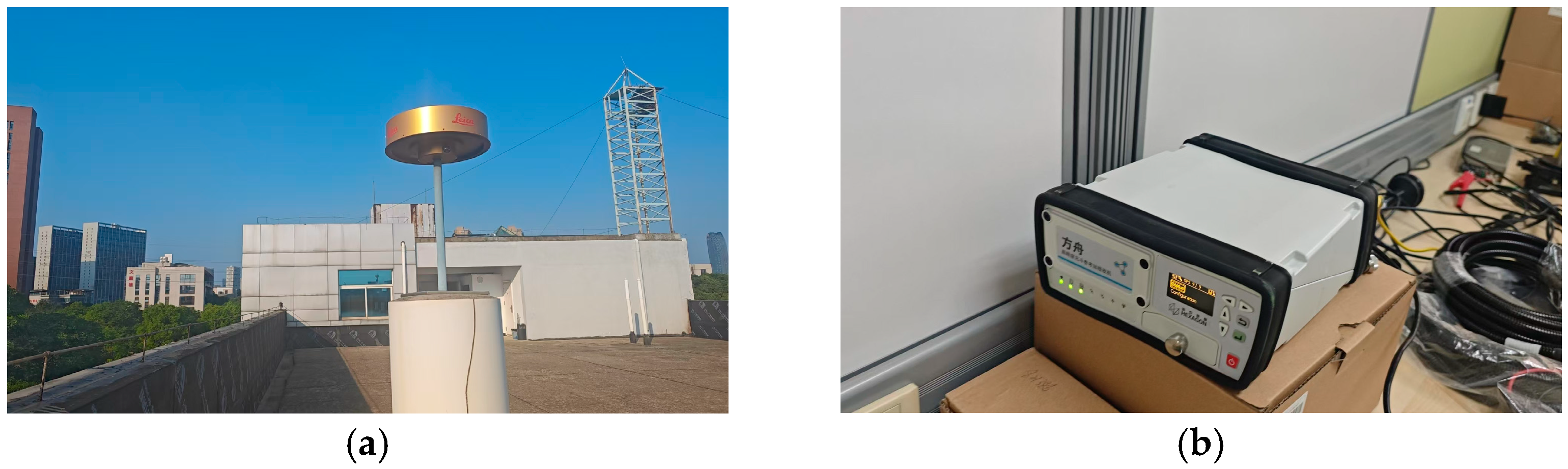
2.1. GNSS Observations

The original code and phase observations from the GPS and BDS satellites are collected by the antenna and receiver, which are parts of the monitoring system, as shown in Figure 1. To be specific, the Leica AR20 multi-GNSS antenna (Leica Geosystems AG, Heerbrugg, Switzerland) is placed on the roof without being blocked by the surroundings, and the receiver is the Hexagon FangZhou receiver (Hexagon Geosystems (Qingdao) Co., Ltd., Qingdao, China), which can decode signals from both GPS and BDS satellites. The GNSS observation will be transferred to the IPC, in which the raw data will be stored and processed through the NRT processing mode for water vapor monitoring.

2.2. GNSS Satellite Ephemeris

Satellite ephemeris in this study include three products. First, orbit and clock offset corrections provided by the BDS PPP-B2b service are directly captured and decoded by the Hexagon FangZhou receiver in the State Space Representation (SSR) format. The B2b ephemeris can be obtained with the combination of SSR and navigation message. Second, the final multi-GNSS ephemeris from Wuhan University (WUM) are collected and applied for the post-processing [32], which will serve as the reference for the following evaluation. In addition, the real-time multi-GNSS ephemeris generated by the China Academy of Science (CAS) are also collected and applied for processing for comparison [33]. Except for the B2b ephemeris, satellite products from WUM and CAS can both be obtained from the IGS (https://igs.org/products/#about, accessed on 12 June 2025).

2.3. ERA5 Reanalysis
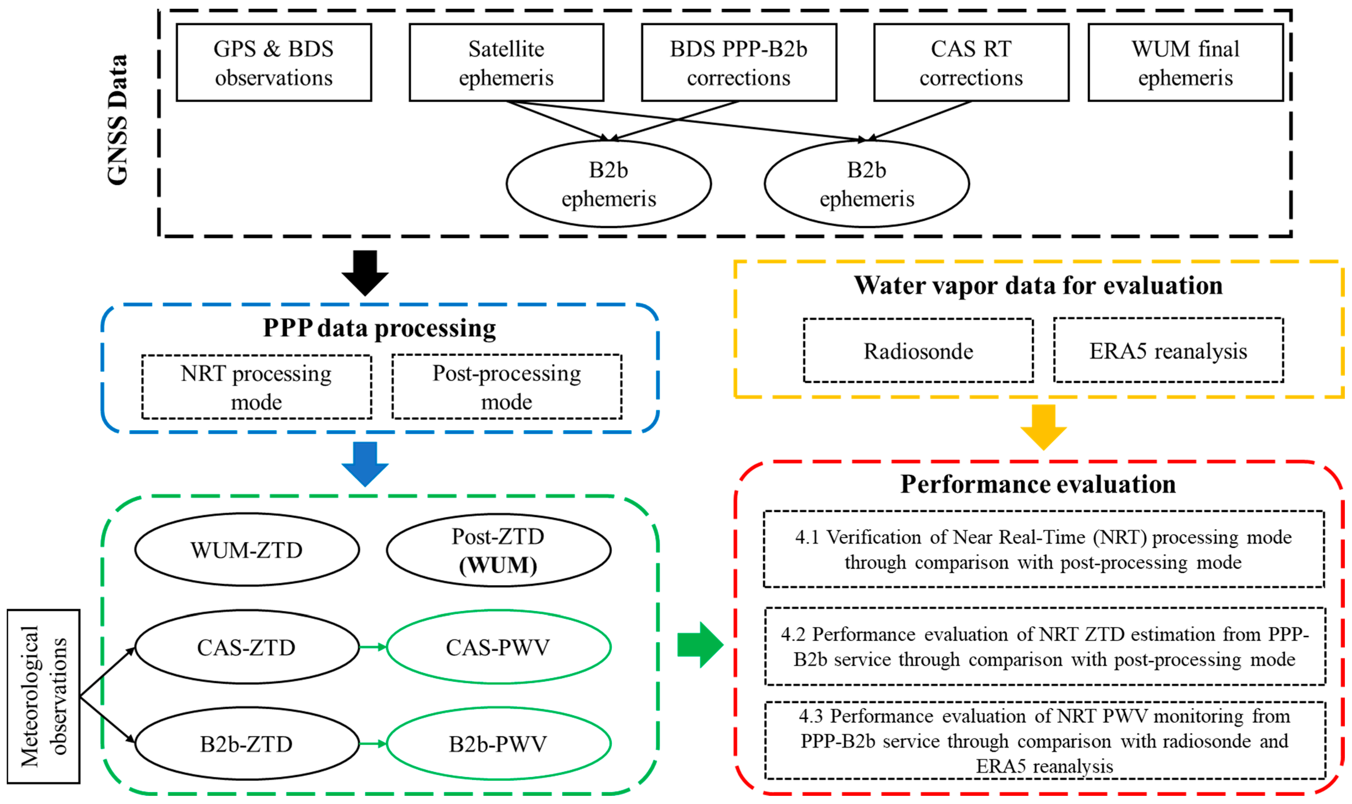
The fifth generation ECMWF reanalysis (ERA5) in pressure-level format is employed in this study. It can provide meteorological variables for 37 specific pressure levels from the earth’s surface to about 80 km [34]. The specific humidity of ERA5 reanalysis will be integrated into PWV for water vapor accuracy assessment in this study. The detailed method for the integration process can be found in [35]. The ERA5 reanalysis can be downloaded from the Climate Data Store (CDS) via https://cds.climate.copernicus.eu/datasets/reanalysis-era5-pressure-levels?tab=overview (accessed on 12 June 2025).

3. Methodology

This section detailly describes the methods used for the evaluation experiments, including the GNSS data processing and the following performance evaluation process. A general flow chart of this experiment is presented in Figure 2 as follows.

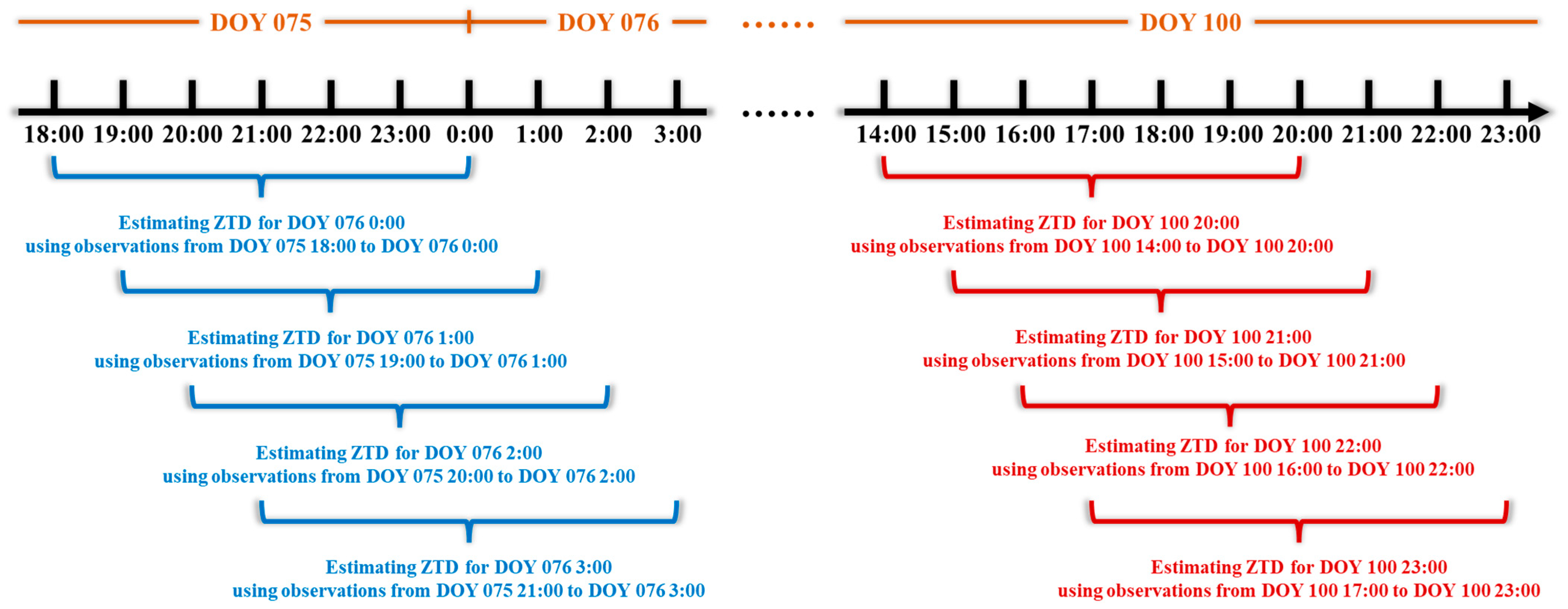
3.1. GNSS Data Processing

To achieve the monitoring of water vapor based on GNSS observations, the PPP technique is applied for processing the original code and phase observations from GPS and BDS. There are two processing modes included in this study, i.e., the post-processing mode and NRT processing mode. The post-processing mode is to conventionally process GNSS observations with final satellite ephemeris (e.g., WUM) on a daily basis (24 h processing length). It is widely employed for generating ZTD products (e.g., [36]). The detailed strategies for post-processing mode are given in Table 1. The priori values for tropospheric parameters are obtained from the Saastamoinen model [37] and the Global Pressure and Temperature 3 (GPT3) [38]. The Vienna Mapping Function 3 (VMF3) is adopted for mapping the tropospheric delay from the zenith direction to the slant signal paths [38]. All observations are processed with the interval of 30 s, and the tropospheric parameters are estimated every 3600 s.
Different from the post-processing mode, the NRT processing mode only adopts 6 h data for each processing to estimate ZTD for the final epoch. The length of 6 h is selected due to the consideration for both ZTD and ambiguity convergence [39]. The general schematic diagram for the NRT processing mode is shown as Figure 3. Apart from the data length, the key difference between two modes is the satellite ephemeris. The NRT mode applies two RT ephemeris (i.e., CAS and B2b) for data processing to achieve timeliness for water vapor monitoring. The processing software is secondary developed on the basis of the Geodetic SpatioTemporal data Analysis and Research (GSTAR) software (v.1.0) developed by Beihang University [40]. It is installed on the IPC of the monitoring system and will be launched every hour for water vapor monitoring.

3.2. PWV Conversion Based on Estimated ZTD

To achieve the water vapor monitoring based on GNSS technique, the conversion of PWV from the estimated ZTD will be conducted after GNSS data processing. First, the ZHD is calculated through the Saastamoinen model and the in-situ pressure observations from the monitoring system, as follows:
Z h = 2.279 ± 0.0024 1 0.00266 cos ( 2 φ ) 0.00028 h × P
where Z h represents the ZHD, φ and h are the latitude and height of GNSS antenna, and P is the pressure measurement in hPa unit. Afterwards, the ZWD can be obtained after removing ZHD from the estimated ZTD. Finally, PWV can be converted with ZWD ( Z w ) and the conversion factor as follows:
W g = Π × Z w = 1 0 6 ρ w R V ( k 3 T m + k 2 ) × Z w
where W g represents PWV converted from ZWD ( Z w ) and the conversion factor ( Π ). ρ w and R V are the density of liquid water and universal gas constant for wet air. k 2 and k 3 represent coefficients of atmospheric refractivity. T m is the weighted mean temperature, which can be calculated through the air temperature measurement and linear coefficient from Yao et al. (2014) [41].

4. Results and Discussion

To analyze the practical applicability of the BDS PPP-B2b service in water vapor monitoring, ZTD and PWV retrieved from the monitoring system for a total of 25 days from day-of-year (DOY) 076 to 100 in 2025 are analyzed in this section. Firstly, the consistency of NRT processing mode and post-processing mode for ZTD estimation are firstly verified. Subsequently, to analyze the performance of the PPP-B2b service, ZTD estimated from two RT ephemeris (i.e., CAS and PPP-B2b) based on NRT processing mode are evaluated through comparison with post-processed ZTD. Finally, the accuracy of PWV from the monitoring system is assessed with that from ERA5 reanalysis to prove the feasibility of PPP-B2b service in water vapor monitoring.

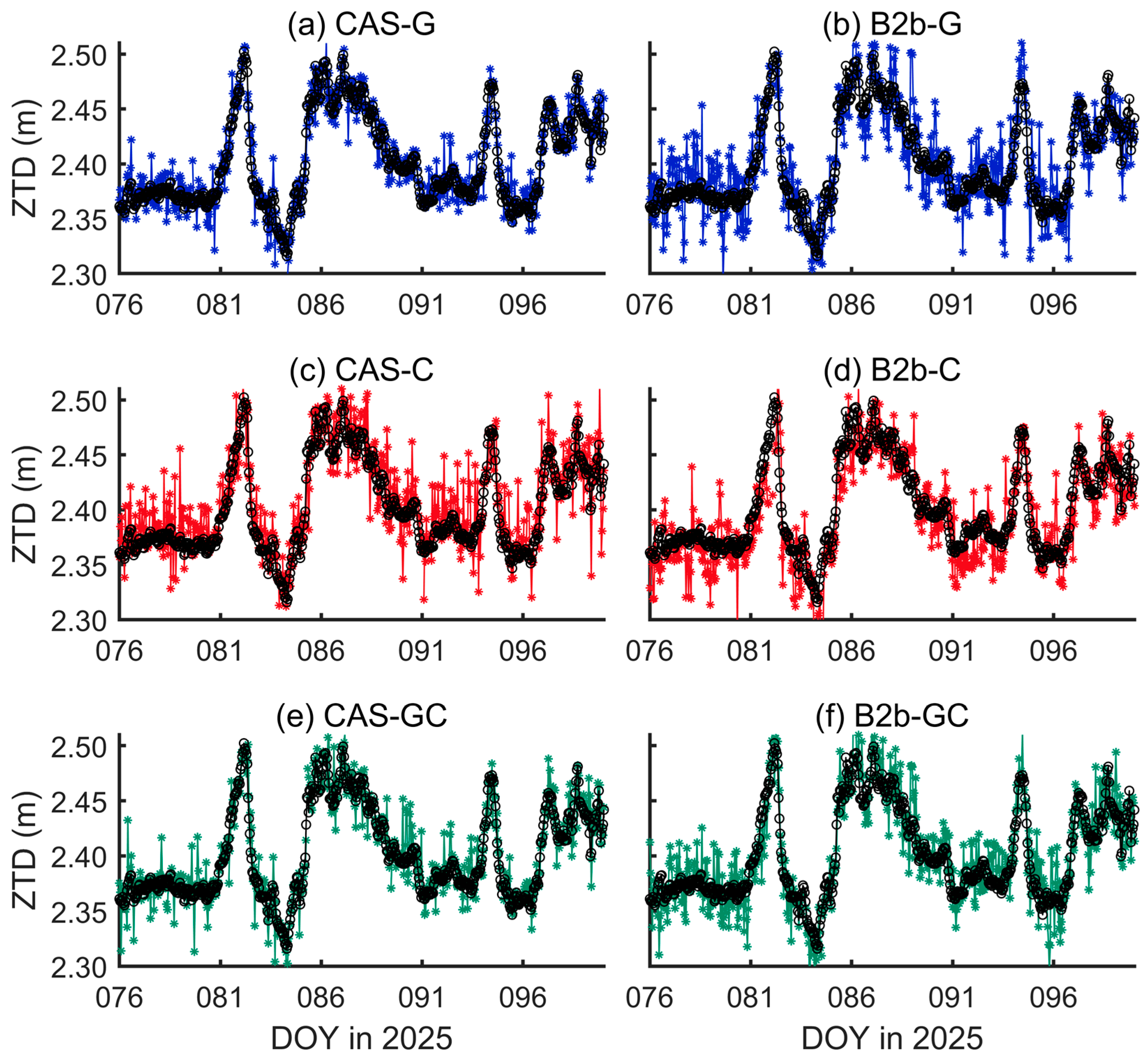
4.1. Verification of Near Real-Time (NRT) Processing Mode Through Comparison with Post-Processing Mode

This subsection first verifies the effectiveness of the NRT processing mode adopted by the monitoring system. To achieve the verification requirements, ZTD estimated from the post-processing mode using WUM final ephemeris products with GPS-only observations is adopted as the reference. Afterwards, the original GPS and BDS observations for a total of 25 days from DOY 076 to DOY 100 in 2025 are consistently processed via the PPP technique on a daily batch. The processing strategy are exhibited in Table 1. Based on the consistent strategies for parameter and input data (including GNSS observations and satellite ephemeris), ZTD time series in 1 h temporal resolution can be obtained for the entire research period. This guarantees that the comparison between ZTD from NRT and post-processing mode are generally in accordance, despite the satellite utilization and processing mode. For satellite utilization, three combinations of satellite systems are selected, i.e., the GPS-only (G), BDS-only (C), and the combination of GPS and BDS (GC). The time series of ZTD estimated from different satellite combinations during the entire research period are shown in Figure 4. In all subplots of Figure 4, the black lines represent the referenced ZTD time series estimated using WUM final ephemeris in post-processing mode, while ZTD time series in NRT processing mode for G/C/GC combinations are illustrated in blue, red, and green, respectively. It can be observed from the figures that no matter which satellite combination is adopted, ZTD estimated by the NRT processing mode can be well consistent with the results from the post-processing mode. However, three time series of ZTD estimated from NRT processing mode are all less smooth than that from post-processing mode, exhibiting some distinguished outliers. This may be attributed to the fact that the accuracy of RT ephemeris (i.e., CAS and B2b) is generally worse than the final ephemeris for some epochs, which influences the accuracy of data processing [8]. Afterwards, two accuracy indicators, i.e., the bias and RMS of ZTD error, are utilized for quantification. It shows that the bias of ZTD using GPS-only observation is close to 0.01 mm, and the corresponding RMS is 6.91 mm. The phenomenon that almost no bias exists is possibly attributed to the fact that the ZTD reference from the post-processing mode was also estimated using the GPS-only observation, thus guaranteeing the consistency. This also partly proves the consistency between the NRT processing mode and the post-processing mode. In contrast, the estimation result of BDS-only manifests a relatively large bias with the value of −3.39 mm, manifesting an evident bias between the processing results. This might be because of the poorly calibrated antenna-related error for the BDS satellites. According to previous research (e.g., [42,43]), the authors have also discovered that the significant systemic biases exist for ZTD derived from BDS and GPS constellations. They attributed this to the poorly calibrated PCO/PCV errors for BDS satellites, which in turn influences the performance of data processing, while for the GPS and BDS combination, the bias of ZTD is closer to 0 than that of BDS-only result with the value of −2.15 mm. This should be because the joint processing after introducing GPS observations can improve the robustness and accuracy of parameter estimation [8]. ZTD RMS from the combined GPS and BDS is the smallest with the value of 6.88 mm, revealing a tiny improvement of about 0.03 mm. This accuracy is basically consistent with previous studies [40]. In general, the NRT processing mode can obtain comparable ZTD estimation to those from the post-processing mode. Therefore, the NRT mode implanted on the monitoring system can be used for water vapor monitoring.

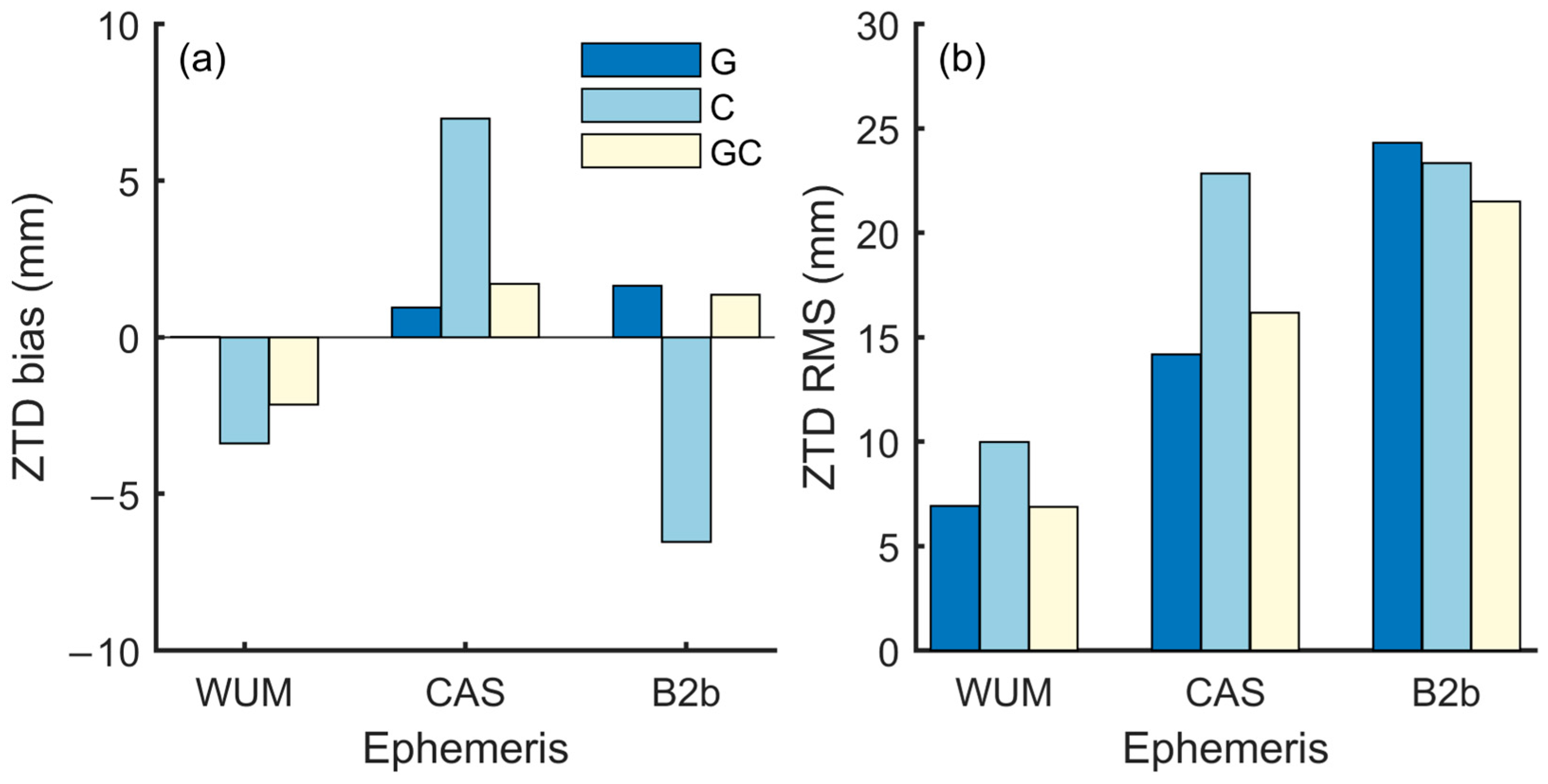
4.2. Performance Evaluation of NRT ZTD Estimation from PPP-B2b Service Through Comparison with Post-Processing Mode

Subsequently, the accuracy of ZTD estimated through the NRT processing mode from the monitoring system is evaluated to analyze the performance of the PPP-B2b service. For the same observations, the real-time ephemeris provided by CAS through IGS RTS and that from the PPP-B2b service were, respectively, adopted in the monitoring system based on the NRT processing mode. Three satellite combinations including G/C/GC are applied for ZTD estimation. Figure 5 presents the time series of NRT ZTD estimated using different RT ephemeris (i.e., CAS and B2b) with different satellite combinations during the research period. Overall, ZTD results estimated from the CAS and B2b product are relatively consistent with the reference values. However, compared with the reference obtained by the post-processing mode, ZTD estimated using two RT ephemeris (CAS and B2b) has more significant fluctuations and some outlier. This feature is more obvious for B2b results, which might be due to the relatively lower accuracy of B2b ephemeris compared with CAS products [44].
The corresponding bias and RMS of ZTD error evaluated by ZTD from the post-processing mode are summarized in Figure 6, including the NRT processing results with WUM final ephemeris. Statistics results of accuracy indicators show that the bias of ZTD estimation for the CAS ephemeris with the satellite combination of GPS-only, BDS-only, and GPS and BDS combinations are 0.95, 6.98, and 1.71 mm, respectively, and the corresponding RMS are 14.18, 22.85, and 16.16 mm, respectively, while these values for B2b ephemeris are 1.64, −6.54, 1.35 mm for bias, and 24.32, 23.34, 21.49 mm for RMS. These numerical results are basically similar to previous studies [31], that is, ZTD accuracy based on PPP-B2b service is approximately 20 mm. Although the performance of B2b is slightly worse than that of CAS products, according to the theory of error propagation [45], the corresponding PWV accuracy can achieve around 4 mm with PPP-B2b service. This can basically meet the requirements of real-time water vapor monitoring for meteorological applications [24].

4.3. Performance Evaluation of NRT PWV Monitoring from PPP-B2b Service Through Comparison with ERA5 Reanalysis

Finally, the accuracy of PWV monitored through NRT processing mode from the monitoring system are evaluated to verify the practical effectiveness of the PPP-B2b service for water vapor monitoring. PWV is converted using ZTD and in situ meteorological observations from the monitoring system with the method described in Section 3. Different from ZTD, the assessment of PWV was conducted using that from the radiosonde observations from the adjacent meteorological stations (with a horizontal distance of about 15 km) and ERA5 reanalysis products, which has been proven to be a valid external reference for evaluating water vapor [35,46]. The radiosonde-derived PWV data for the research period can be directly retrieved from the GNSS meteorological ensemble tools (GMET) [35]. Figure 7 exhibits the scatter plots of PWV retrieved from radiosonde observations (Radio-PWV) and monitored from two RT ephemeris (i.e., CAS and B2b) with different satellite combinations during the research period. It can be observed from Figure 7 that PWV from all combinations reveals consistency with the radiosonde observations. The correlation coefficients for all combinations are higher than 0.85. For the accuracy indicators, results show that the bias of PWV monitored based on the B2b ephemeris using the combination of G, C, and GC satellite combinations are −0.14, −2.21, and 0.14 mm, respectively, and the corresponding RMS are 3.71, 4.66, and 3.73 mm, respectively, while those values for the results from B2b ephemeris are 0.20, 1.82, and 0.42mm for bias, and 2.05, 4.31, and 2.41 mm for RMS. Compared to the B2b results, PWV monitored with CAS ephemeris generally exhibit better accuracy with about 45%, 8%, and 35% for G, C, and GC satellite combinations. The obviously better accuracy for the G and GC combinations indicates that the quality of orbit and clock offset for GPS satellite from B2b services are generally lower than those from CAS ephemeris. While the general tiny improvements for the BDS-only combinations reveals that the qualities for BDS satellites from two RT ephemeris are generally consistent. Despite that the performance of water vapor monitored with B2b ephemeris being worse, the accuracy is about 3 to 4 mm compared to radiosonde observations, which can be reliably applied for meteorological research and operations [46].
Figure 8 exhibits the time series of PWV monitored through the NRT processing mode using two RT ephemeris (i.e., CAS and B2b) with different satellite combinations during the research period. For clearer illustration, the bias and RMS for PWV monitored with two RT ephemeris are summarized in Table 2. In general, the variation in PWV in the temporal scale monitored by CAS and B2b products are generally consistent with the reference values from the ERA5 reanalysis products. Correlating analysis indicates that the correlations between PWV monitored from different combinations all exhibit high value greater than 0.95. In addition, PWV time series obtained by the NRT processing mode also has relatively obvious fluctuations and outliers, which is similar to the results of ZTD above. This is potentially due to the fact that the stability and accuracy of the real-time product (CAS and B2b) are lower compared to the final product (WUM). For accuracy statistical results, it shows that the bias of PWV monitored based on the CAS ephemeris using the combination of G, C, and GC satellite combinations are −0.34, −1.32, and −0.29 mm, respectively, and the corresponding RMS are 2.94, 4.36, and 3.46 mm, respectively, while those values for the results from B2b ephemeris are −0.23, 0.96, −0.29 mm for bias, and 4.55, 4.40, 3.95 mm for RMS. These values are generally about 1/6 of the ZTD error, which is consistent with the theory of error propagation mentioned above. Compared with B2b results, PWV monitored from CAS ephemeris exhibits better accuracy of about 35%, 1%, and 12% for G, C, and GC satellite combinations. Similarly to the results compared with radiosonde observations, the G and GC combinations reveals more obviously better accuracy, which might be due to the lower quality of orbit and clock offset for the GPS satellite from B2b services, while the general consistent accuracy for the BDS-only combinations (~1%) manifests the similar qualities for BDS satellites from two RT ephemeris. Basically, these numerical results are consistent with previous studies [29,30], that is, the accuracy that can be achieved by about 4 mm using the PPP-B2b service.
It should be noted that among the CAS results, PWV monitored with GPS-only observation performs the best, followed by that from the GPS and BDS combination, and the BDS-only performs the worst. In contrast, for the results of B2b, PWV monitored with GPS-only performed the worst, followed by that of BDS-only, and the GPS and BDS combination performed the best. This might be because that the production of the B2b ephemeris mainly relies on some domestic stations in China and about 30 global stations [44], which leads to the relatively low accuracy for GPS satellites. Therefore, the accuracy is relatively lower when using GPS-only observations for PWV monitoring based on the B2b ephemeris. However, when the BDS satellites were introduced to form dual-system observations, the estimation of ZTD and the subsequent PWV monitoring were improved, as is reported in previous research [8,39]. Based on the above analysis, the water vapor monitoring based on the BDS PPP-B2b service can generally meet the demand for NRT monitoring, and it is expected to be promoted and contribute to the extreme weather forecasting in the near future.

5. Conclusions

The PPP-B2b service has significant potential for application in meteorological fields, such as standalone water vapor monitoring in depopulated areas without Internet. While most current studies are generally based on the simulated real-time PPP mode, analyzing its practical performance should be conducted. For this purpose, a continuously operated water vapor monitoring system using the PPP-B2b service was established in Wuhan, China.
The effectiveness of the NRT processing mode adopted by the monitoring system is firstly verified through comparison of ZTD estimated from the post-processing mode. Subsequently, the accuracy of ZTD estimated through the NRT processing mode using two RT ephemeris is evaluated. Accuracy results show that the RMS of ZTD error for the B2b ephemeris are 24.32, 23.34, 21.49 mm, respectively. These values were generally comparable with those from CAS ephemeris, which can basically meet the requirements for the following conversion to water vapor.
Finally, the accuracy of PWV monitored through the NRT processing mode are evaluated to verify the practical performance of PPP-B2b service. Taking PWV from radiosonde observations as the reference, RMS of PWV based on B2b ephemeris are 3.71, 4.66, and 3.73 mm for G, C, and GC combinations, respectively, while those values are 4.55, 4.40, 3.95 mm for G, C, and GC combinations, respectively. These accuracies are generally comparable with those from CAS ephemeris and can generally meet the demand for NRT water vapor monitoring. To sum up, water vapor monitoring based on the BDS PPP-B2b service is feasible to be promoted to operational meteorology.
Future work lies in two directions. First, the assessment in the presented study generally adopts GPS estimation as the reference, while further analysis with more satellite systems (e.g., GLONASS and Galileo) can provide a more comprehensive perspective on the performance of water vapor monitoring using BDS PPP-B2b service. Second, this study only contains results of 25 days in a single place, while a further evaluation with a longer time span and more stations should be conducted. The characteristics of accuracy in different seasons (including rainy and non-rainy periods) and areas can be explored. This will provide a more robust reference for its promotion in the near future.

Author Contributions

Conceptualization, Y.C.; methodology, Y.C. and L.Z.; software, L.Z. validation, L.Z. and Y.C.; formal analysis, L.Z.; investigation, Y.C.; resources, Y.C. and H.L.; data curation, L.Z., E.Z., Z.H. and Y.C.; writing—original draft preparation, L.Z.; writing—review and editing, Y.C. and H.L.; visualization, L.Z., X.L. and M.Q.; supervision, Y.C. and H.L.; project administration, Y.C. and H.L.; funding acquisition, Y.C. and H.L. All authors have read and agreed to the published version of the manuscript.

Funding

This research was funded by the National Natural Science Foundation of China (Grant No. U2442214), the Observational Experiment Project of Meteorological Observation Center of China Meteorological Administration (Grant No. GCSYJH24-21, GCSYJH24-02), and the Innovation and development project of China Meteorological Administration (Grant No. CXFZ2024J061).

Institutional Review Board Statement

Not applicable.

Informed Consent Statement

Not applicable.

Data Availability Statement

All data that support the findings of this study are included within the article.

Acknowledgments

The authors are grateful to the ECMWF for providing the ERA5 reanalysis products.

Conflicts of Interest

The authors declare no conflicts of interest.

Abbreviations

The following abbreviations are used in this manuscript:
BDSBeiDou navigation satellite system
CASChina Academy of Science
CDSClimate Data Store
DOYDay-of-Year
ECMWFEuropean Centre for Medium-Range Weather Forecasts
ERA5The Fifth Generation ECMWF Reanalysis
GEOGeostationary Earth Orbit
GLONASSGLObal NAvigation Satellite System
GNSSGlobal Navigation Satellite System
GPSGlobal Positioning System
IGSInternational GNSS Services
IPCIndustrial Personal Computer
NRTNear Real-time
PPPPrecise Point Positioning
PWVPrecipitable Water Vapor
RTReal-time
RTSReal-Time Service
ZHDZenith Hydrostatic Delay
ZTDZenith Tropospheric Delay
ZWDZenith Wet Delay

References

  1. Trenberth, K.E.; Christy, J.R.; Olson, J.G. Global atmospheric mass, surface pressure, and water vapor variations. J. Geophys. Res. Atmos. 1987, 92, 14815–14826. [Google Scholar] [CrossRef]
  2. Sherwood, S.C.; Roca, R.; Weckwerth, T.M.; Andronova, N.G. Tropospheric water vapor, convection, and climate. Rev. Geophys. 2010, 48, Rg2001. [Google Scholar] [CrossRef]
  3. Zhou, L.H.; Cao, Y.C.; Shi, C.; Liang, H.; Fan, L. Quantifying the Atmospheric Water Balance Closure over Mainland China Using Ground-Based, Satellite, and Reanalysis Datasets. Atmosphere 2024, 15, 497. [Google Scholar] [CrossRef]
  4. Neelin, J.D.; Martinez-Villalobos, C.; Stechmann, S.N.; Ahmed, F.; Chen, G.; Norris, J.M.; Kuo, Y.H.; Lenderink, G. Precipitation Extremes and Water Vapor Relationships in Current Climate and Implications for Climate Change. Curr. Clim. Change Rep. 2022, 8, 17–33. [Google Scholar] [CrossRef]
  5. Chen, X.L.; Xu, X.D.; Ma, Y.M.; Wang, G.L.; Chen, D.L.; Cao, D.B.; Xu, X.; Zhang, Q.; Li, L.H.; Liu, Y.J.; et al. Investigation of Precipitation Process in the Water Vapor Channel of the Yarlung Zsangbo Grand Canyon. Bull. Am. Meteorol. Soc. 2024, 105, e370–e386. [Google Scholar] [CrossRef]
  6. Liu, Y.; Yan, X.; Yao, Y.B.; Zhang, B.; Zhao, Q.Z.; Wang, X.Q.; E, S.L.; Zhang, L. Revealing the synergistic contribution of PWV and CAPE to extreme precipitation throughout China. Adv. Space Res. 2025, 75, 2739–2752. [Google Scholar] [CrossRef]
  7. Emardson, T.R.; Johansson, J.M. Spatial interpolation of the atmospheric water vapor content between sites in a ground-based GPS network. Geophys. Res. Lett. 1998, 25, 3347–3350. [Google Scholar] [CrossRef]
  8. Lu, C.X.; Chen, X.H.; Liu, G.; Dick, G.; Wickert, J.; Jiang, X.Y.; Zheng, K.; Schuh, H. Real-Time Tropospheric Delays Retrieved from Multi-GNSS Observations and IGS Real-Time Product Streams. Remote Sens. 2017, 9, 1317. [Google Scholar] [CrossRef]
  9. Zhou, L.H.; Fan, L.; Shi, C. Evaluation and Analysis of Remotely Sensed Water Vapor from the NASA VIIRS/SNPP Product in Mainland China Using GPS Data. Remote Sens. 2023, 15, 1528. [Google Scholar] [CrossRef]
  10. Ning, T.; Wang, J.; Elgered, G.; Dick, G.; Wickert, J.; Bradke, M.; Sommer, M.; Querel, R.; Smale, D. The uncertainty of the atmospheric integrated water vapour estimated from GNSS observations. Atmos. Meas. Tech. 2016, 9, 79–92. [Google Scholar] [CrossRef]
  11. Bevis, M.; Businger, S.; Herring, T.A.; Rocken, C.; Anthes, R.A.; Ware, R.H. GPS meteorology: Remote sensing of atmospheric water vapor using the global positioning system. J. Geophys. Res. Atmos. 1992, 97, 15787–15801. [Google Scholar] [CrossRef]
  12. Maciejewska, A. Use of Tropospheric Delay in GNSS-Based Climate Monitoring-A Review. Remote Sens. 2025, 17, 1501. [Google Scholar] [CrossRef]
  13. Bevis, M.; Businger, S.; Chiswell, S.; Herring, T.A.; Anthes, R.A.; Rocken, C.; Ware, R.H. GPS meteorology: Mapping zenith wet delays onto precipitable water. J. Appl. Meteorol. Climatol. 1994, 33, 379–386. [Google Scholar] [CrossRef]
  14. Zhang, W.X.; Lou, Y.D.; Cao, Y.C.; Liang, H.; Shi, C.; Huang, J.F.; Liu, W.X.; Zhang, Y.; Fan, B.B. Corrections of Radiosonde-Based Precipitable Water Using Ground-Based GPS and Applications on Historical Radiosonde Data Over China. J. Geophys. Res. Atmos. 2019, 124, 3208–3222. [Google Scholar] [CrossRef]
  15. Zhou, L.H.; Fan, L.; Shi, C.; Liang, H.; Cao, Y.C. Comprehensive analysis of zenith tropospheric delay and precipitable water vapor retrieved from BDS-3 B1C and B2a signals. Measurement 2025, 242, 116079. [Google Scholar] [CrossRef]
  16. Wang, M.H.; Wang, J.X.; Bock, Y.; Liang, H.; Dong, D.A.; Fang, P. Dynamic Mapping of the Movement of Landfalling Atmospheric Rivers Over Southern California With GPS Data. Geophys. Res. Lett. 2019, 46, 3551–3559. [Google Scholar] [CrossRef]
  17. Zhou, L.H.; Fan, L.; Zhang, W.X.; Shi, C. Long-term correlation analysis between monthly precipitable water vapor and precipitation using GPS data over China. Adv. Space Res. 2022, 70, 56–69. [Google Scholar] [CrossRef]
  18. Wu, Z.L.; Lu, C.X.; Liu, Y.; Lin, H.; Zheng, Y.X.; Wei, Q.; Liu, Y.X. Global statistical assessment of Haiyang-2B scanning microwave radiometer precipitable water vapor. Front. Earth Sci. 2023, 11, 1084285. [Google Scholar] [CrossRef]
  19. Wang, H.S.; Liu, Y.B.; Liu, Y.W.; Cao, Y.C.; Liang, H.; Hu, H.; Liang, J.S.; Tu, M.H. Assimilation of GNSS PWV with NCAR-RTFDDA to Improve Prediction of a Landfall Typhoon. Remote Sens. 2022, 14, 178. [Google Scholar] [CrossRef]
  20. Liu, Y.; Zhang, B.; Yao, Y.B.; Zhao, Q.Z.; Xu, C.Q.; Yan, X.; Zhang, L. Revealing the spatiotemporal patterns of water vapor and its link to North Atlantic Oscillation over Greenland using GPS and ERA5 data. Sci. Total Environ. 2024, 918, 170596. [Google Scholar] [CrossRef] [PubMed]
  21. Li, L.J.; Wu, S.Q.; Zhang, K.F.; Wang, X.M.; Li, W.; Shen, Z.; Zhu, D.T.; He, Q.M.; Wan, M.F. A new zenith hydrostatic delay model for real-time retrievals of GNSS-PWV. Atmos. Meas. Tech. 2021, 14, 6379–6394. [Google Scholar] [CrossRef]
  22. Li, H.J.; Li, X.M.; Kang, Q. Handling Method for Outages of IGS Real-Time Service (RTS) in GNSS Real-Time Sensing of Atmospheric Water Vapor. IEEE J. Sel. Top. Appl. Earth Obs. Remote Sens. 2023, 16, 8310–8318. [Google Scholar] [CrossRef]
  23. Paz, J.M.A.; Mendoza, L.P.O.; Fernández, L.I. Near-real-time GNSS tropospheric IWV monitoring system for South America. GPS Solut. 2023, 27, 93. [Google Scholar]
  24. Wang, H.; He, J.X.; Wei, M.; Zhang, Z.D. Synthesis Analysis of One Severe Convection Precipitation Event in Jiangsu Using Ground-Based GPS Technology. Atmosphere 2015, 6, 908–927. [Google Scholar] [CrossRef]
  25. Du, M.B.; Cao, Y.C.; Liang, H.; Hu, H.; Wang, H.S.; Song, S.L.; Jiao, G.Q. Construction of a meteorological application system based on BDS ground-based augmentation network and water vapor products validation. GPS Solut. 2024, 28, 107. [Google Scholar] [CrossRef]
  26. Yang, Y.X.; Ding, Q.; Gao, W.G.; Li, J.L.; Xu, Y.Y.; Sun, B.J. Principle and performance of BDSBAS and PPP-B2b of BDS-3. Satell. Navig. 2022, 3, 5. [Google Scholar] [CrossRef]
  27. Yang, H.; He, X.F.; Ferreira, V.; Ji, S.Y.; Xu, Y.; Song, S.S. Assessment of precipitable water vapor retrieved from precise point positioning with PPP-B2b service. Earth Sci. Inf. 2023, 16, 315–328. [Google Scholar] [CrossRef]
  28. Cao, Y.C.; Cheng, Z.H.; Liang, J.S.; Zhao, P.P.; Cao, Y.C.; Wang, Y.Z. Performance of Ground-Based Global Navigation Satellite System Precipitable Water Vapor Retrieval in Beijing with the BeiDou B2b Service. Remote Sens. 2024, 16, 2902. [Google Scholar] [CrossRef]
  29. Wang, X.M.; Chen, Y.F.; Zhang, J.L.; Qiu, C.; Zhou, K.; Li, H.B.; Huang, Q.Y. Assessment of BDS-3 PPP-B2b Service and Its Applications for the Determination of Precipitable Water Vapour. Atmosphere 2024, 15, 1048. [Google Scholar] [CrossRef]
  30. Xu, Y.; Zhao, P.P.; Wang, J. Precipitable water vapor retrieval for rainfall forecasting using BDS-3 PPP-B2b signal in the coastal region of China. Meas. Sci. Technol. 2024, 35, 116309. [Google Scholar] [CrossRef]
  31. Zhou, P.Y.; Zhang, Z.K.; Liu, Z.J.; Lyu, D.; Xiao, G.R.; Xiao, K.; Du, L. Real-Time Precise Zenith Tropospheric Delay Estimation with BDS PPP-B2b, Galileo HAS, and QZSS MADOCA-PPP Services. IEEE Trans. Geosci. Remote Sens. 2024, 62, 5802011. [Google Scholar] [CrossRef]
  32. Guo, J.; Xu, X.L.; Zhao, Q.L.; Liu, J.N. Precise orbit determination for quad-constellation satellites at Wuhan University: Strategy, result validation, and comparison. J. Geod. 2016, 90, 143–159. [Google Scholar] [CrossRef]
  33. Lee, Z.; Wang, L.; Wang, N.; Li, Y.; Liu, A.; Li, M.; Lee, Z. Performance Assessment and Integrity Support Information Estimation of CAS Real-time Orbits and Clocks Products. Geomat. Inf. Sci. Wuhan Univ. 2024, 1–19. [Google Scholar] [CrossRef]
  34. Hersbach, H.; Bell, B.; Berrisford, P.; Hirahara, S.; Horányi, A.; Muñoz-Sabater, J.; Nicolas, J.; Peubey, C.; Radu, R.; Schepers, D.; et al. The ERA5 global reanalysis. Q. J. R. Meteorol. Soc. 2020, 146, 1999–2049. [Google Scholar] [CrossRef]
  35. Zhang, W.X.; Lou, Y.D.; Zhou, Y.Z.; Liu, M.J.; Zhang, Z.Y.; Ou, S.Y.; Liu, J.N. GNSS meteorological ensemble tools (GMET): A free-access online service for GNSS meteorological applications. GPS Solut. 2024, 28, 202. [Google Scholar] [CrossRef]
  36. Byun, S.H.; Bar-Sever, Y.E. A new type of troposphere zenith path delay product of the international GNSS service. J. Geod. 2009, 83, 367–373. [Google Scholar] [CrossRef]
  37. Saastamoinen, J. Atmospheric correction for the troposphere and stratosphere in radio ranging satellites. Geophys. Monogr. 1972, 15, 247–251. [Google Scholar]
  38. Landskron, D.; Böhm, J. VMF3/GPT3: Refined discrete and empirical troposphere mapping functions. J. Geod. 2018, 92, 349–360. [Google Scholar] [CrossRef] [PubMed]
  39. Lu, C.X.; Feng, G.L.; Zheng, Y.X.; Zhang, K.K.; Tan, H.; Dick, G.; Wickert, J. Real-Time Retrieval of Precipitable Water Vapor from Galileo Observations by Using the MGEX Network. IEEE Trans. Geosci. Remote Sens. 2020, 58, 4743–4753. [Google Scholar] [CrossRef]
  40. Shi, C.; Guo, S.W.; Fan, L.; Gu, S.F.; Fang, X.Q.; Zhou, L.H.; Zhang, T.; Li, Z.; Li, M.; Li, W.W.; et al. GSTAR: An innovative software platform for processing space geodetic data at the observation level. Satell. Navig. 2023, 4, 18. [Google Scholar] [CrossRef]
  41. Yao, Y.B.; Zhang, B.; Xu, C.Q.; Chen, J.J. Analysis of the global Tm-Ts correlation and establishment of the latitude-related linear model. Chin. Sci. Bull. 2014, 59, 2340–2347. [Google Scholar] [CrossRef]
  42. Lu, C.X.; Li, X.X.; Nilsson, T.; Ning, T.; Heinkelmann, R.; Ge, M.R.; Glaser, S.; Schuh, H. Real-time retrieval of precipitable water vapor from GPS and BeiDou observations. J. Geod. 2015, 89, 843–856. [Google Scholar] [CrossRef]
  43. Zhou, L.H.; Fan, L.; Guo, S.W.; Shi, C. Assessing the feasibility of atmospheric water vapor monitoring with standalone BDS receiver. Environ. Monit. Assess. 2025, 197, 66. [Google Scholar] [CrossRef] [PubMed]
  44. Tang, C.P.; Hu, X.G.; Chen, J.P.; Liu, L.; Zhou, S.S.; Guo, R.; Li, X.J.; He, F.; Liu, J.H.; Yang, J.H. Orbit determination, clock estimation and performance evaluation of BDS-3 PPP-B2b service. J. Geod. 2022, 96, 60. [Google Scholar] [CrossRef]
  45. Wang, J.H.; Zhang, L.Y.; Dai, A.; Van Hove, T.; Van Baelen, J. A near-global, 2-hourly data set of atmospheric precipitable water from ground-based GPS measurements. J. Geophys. Res. Atmos. 2007, 112, D11107. [Google Scholar] [CrossRef]
  46. Shi, C.; Zhou, L.H.; Fan, L.; Zhang, W.X.; Cao, Y.C.; Wang, C.; Xiao, F.; Lü, G.Q.; Liang, H. Analysis of “21·7” extreme rainstorm process in Henan Province using BeiDou/GNSS observation. Chin. J. Geophys. 2022, 65, 186–196. [Google Scholar]
Figure 1. The installation environment of the antenna (a) and Hexagon FangZhou receiver (b), which are part of the water vapor monitoring system.
Applsci 15 08033 g001
Figure 2. Flowchart of the experiment methodology.
Applsci 15 08033 g002
Figure 3. The general schematic diagram for the NRT processing mode.
Applsci 15 08033 g003
Figure 4. Time series of ZTD estimated from NRT processing model using GPS-only ((a), blue), BDS-only ((b), red), and GPS and BDS ((c), green) satellite combinations during the entire research period. The black line in each subfigure represents reference ZTD estimated from post-processing mode.
Applsci 15 08033 g004
Figure 5. Time series of ZTD estimated from NRT processing model using GPS-only (blue), BDS-only (red), and GPS and BDS (green) satellite combinations based on CAS (a,c,e) and B2b ephemeris (b,d,f) during the entire research period. The black line in each subfigure represents reference ZTD estimated from post-processing mode.
Applsci 15 08033 g005
Figure 6. The bias (a) and RMS (b) of ZTD estimation from NRT processing mode using different ephemeris (WUM, CAS, and B2b) with different satellite combinations (G, C, and GC).
Applsci 15 08033 g006
Figure 7. Scatter plots of PWV retrieved from radiosonde observations and monitored from NRT processing model using GPS-only (blue), BDS-only (red), and GPS and BDS (green) satellite combinations based on CAS (a,c,e) and B2b ephemeris (b,d,f) during the entire research period.
Applsci 15 08033 g007
Figure 8. Time series of PWV monitored from NRT processing model using GPS-only (blue), BDS-only (red), and GPS and BDS (green) satellite combinations based on CAS (a,c,e) and B2b ephemeris (b,d,f) during the entire research period. The black line in each subfigure represents reference PWV retrieved from the ERA5 reanalysis.
Applsci 15 08033 g008
Table 1. GNSS data processing strategies for the post-processing model and NRT processing mode.
Title 1Post-Processing ModeNRT Processing Mode
Data length for processing24 h6 h window
Processing interval30 s30 s
Satellite ephemerisWUMWUM (for verification)
CAS or B2b (for evaluation)
EstimatorLeast-squares (LSQ) + backward smoothing
Tropospheric priori modelSaastamoinen + GPT3
Mapping functionVMF3
Stochastic model for ZTDEstimated as piece-wise constant every 3600 s with random walk process between pieces (20 mm/sqrt(h))
Horizontal tropospheric
gradients
Estimated as constant
Receiver coordinatesTightly constrained to double-differenced solutions
Receiver clock offsetsEstimated as white noise
AmbiguityEstimated as arc-constant
Table 2. Statistical results of PWV accuracy monitored from NRT processing mode using CAS and B2b ephemeris with different satellite combinations.
EphemerisSatellite CombinationsBias (mm)RMS (mm)
GPS-only (G)−0.342.94
CASBDS-only (C)−1.324.36
GPS and BDS (GC)−0.293.46
GPS-only (G)−0.234.55
B2bBDS-only (C)0.964.40
GPS and BDS (GC)−0.293.95
Disclaimer/Publisher’s Note: The statements, opinions and data contained in all publications are solely those of the individual author(s) and contributor(s) and not of MDPI and/or the editor(s). MDPI and/or the editor(s) disclaim responsibility for any injury to people or property resulting from any ideas, methods, instructions or products referred to in the content.

